THE NATIVE MOUNTAINEERS.
Reading edition
All kinds of creatures stand and fall By strength of prowess or of wit; ’Tis God’s appointment who must sway, And who is to submit. —Wordsworth.
E are excluded from a knowledge of ancient American history by an impenetrable veil of mystery and silence. The past has left us only relics—relics of things and relics of races—which are interpreted by an unreined imagination. Before Europeans set foot on the western shore of the Atlantic, before the Indians occupied the forest continent, there dwelt on all the sunniest plains and fertile valleys a race well advanced in mechanical and æsthetic art, skilled in war and consecrated in religion. It came and flourished and perished, leaving only monuments of its existence in the form of works of earth, and works of stone—mounds, forts, and pottery. The old mounds scattered everywhere are the sepulchres of illustrious dead, and because of their number, the race has been designated the “Mound Builders.” They inhabited, among other places, the southern Alleghanies, the largest number of mounds being found in the upper valley of the Little Tennessee. Most of the rich mica dikes bear evidence of having been worked centuries ago. The marks of stone picks may still be seen upon the soft feldspar with which the mica is associated, and tunnels and shafts show some knowledge of mining. The fact that a great many ancient mounds all over the country contain skeletons, encased in mica plates, associates these diggings with the builders of the mounds.

The earliest traditional knowledge we have of the habitation of the southern highlands has been handed down by the Cherokees. They say that before they conquered the country and settled in the valleys, the inhabitants were “moon-eyed,” that is, were unable to see during certain phases of the moon. During a period of blindness, the Creeks swept through the mountain passes, up the valleys, and annihilated the race. The Cherokees in turn conquered the Creeks, with great slaughter, which must have occurred at a very ancient date, for the country of their conquest and adoption is the seat of their religious legends and traditional romances.
No definite boundaries can be assigned to the land of any Indian tribe, much less a nation of proud and warlike mountaineers who were happy only when carrying bloodied tomahawks into an enemy’s country. The tribe was distinguished by two great geographical divisions, the Ottari, signifying “among the mountains,” and the Erati, signifying “lowland.” Provincial historians have designated them as “In the Valley” and “Overhill” towns, the great highland belt between the Blue Ridge and Smoky mountains being designated as a valley. The ancient realm of the tribe may, in a general way, be described as the headwater valleys of the Yadkin and Catawba on the east; of the Keowee, Tugaloo, Flint, Etowa and Coosa on the south, and the several tributaries of the Tennessee on the west. There were 60 towns, and 6,000 fighting men could at any time be called by the grand chief to the war path. It was the military prowess of these warriors that gave to the nation the most picturesque and most secure home of all the American tribes. A keen and delicate appreciation of the beautiful in nature, as associated with the grandeur of their surroundings, inspired them to unparalleled heroism in its defense against intrusion. They successfully withstood neighboring tribes, but their contest with the whites was a contest with destiny, in which they yielded only after a long and bloody struggle. The ancient nation of the mountains, expelled from its home, crippled and enervated, but improved in some respects, has found a home in the less picturesque and distant west; but has left a dissevered and withered limb which, like a fossil, merely reminds us of a bygone period of history.
If any one doubts that the Cherokees possessed an appreciative love of country and a genuine sympathy with nature, let him turn to his map, and pronounce those Indian names which have not been cruelly, almost criminally, displaced by English common-places. Let him remember too that there is a meaning in their euphony, and a suggestiveness in their melody. It is a grievous fault, the more grievous because it is irreparable, that so many of the bold streams which thunder down forest slopes and through echoing cañons, have lost those designations whose syllables glide from the tongue in harmony with the music of the crystal currents. Of many natural features the names are preserved, but their meanings have been lost.
East of the Blue Ridge, in North Carolina, very few geographical names of Indian origin have survived. In the valley of the French Broad there is also a barrenness of prehistoric nomenclature. From this circumstance it is argued, and the argument is well sustained, that there was no permanent habitation of Indians in these two localities. The villages were located in valley, and were known by the name of the streams. In some instances, traditions became associated with the name, and in them we have a key to an unwritten scroll. A village, furthermore, gave to a region an importance which made its name widely known, not only in the tribe but among traders and other white adventurers, and thus made it a fixture. There is the additional negative evidence of no permanent habitation, in the fact that mention is no where made, in the annals of military expeditions against the Indians, of villages east of the Balsam mountains. Hunters and warriors penetrated the forests for game, and carried the tomahawk to every frontier, frequently making the Upper Catawba and French Broad valleys their camping ground. While we know nothing about the facts, the presumption is reasonable that at least all the larger rivers and their tributaries were given names by the Indians, which perished with the change of race and ownership.
Catawba is not of Cherokee origin. The river takes its name from the tribe which inhabited its valley until a recent date; South Carolina. It was a species of vandalism to substitute French Broad for Agiqua and Tocheeostee, the former being the name applied by the Erati, or “over the mountain” Cherokees, to the lower valley, and the latter by the Ottari, or “valley” towns, to the upper or North Carolina section below Asheville. “Racing river” is a literal translation of the term Tocheeostee. Above Asheville, where the stream is placid and winds snake-like through the wide alluvions, it took the name Zillicoah.
Swanannoa is one of the most resonant of Indian names, though in being accommodated to English orthography it has lost much of its music. It would be impossible to indicate the original pronunciation. I can, perhaps, tell you nearer how to utter it. Begin with a suppressed sound of the letter “s,” then with tongue and palate lowered, utter the vowel sound of “a” in swan four times in quick succession, giving to the first as much time as to the second two, and raise the voice one note on the last. The word is said to have been derived from the sound made by a raven’s wing as it sweeps through the air. Before white settlers came into the country that species of bird was very plentiful along all the streams, and at their points of confluence were its favorite roosting places, whence, aided by the scent of the water, it sallied up stream in search of food. Hundreds collected at the mouth of the Swanannoa, and the name was the oft repeated imitation, by the voice, of the music of their wings, as they whizzed past the morning camp-fire of the hunter or warrior bands, on the bank of the stream. The hungry, homely, and hated raven is indeed an humble origin for a name so beautiful, applied to an object so much applauded for its beauty.
If the upper tributaries of the French Broad ever had names worthy of their character which have been displaced by such colloquialisms as Cathey’s creek, Davidson’s river, Mills’ river, and Little river, they perished with the race more in sympathy with nature than the inhabitants of the last century. By some chance that gentle stream which snakes through the flat valley of Henderson county, has preserved an Indian designation, though it is probably a borrowed one. Ocklawaha is the name which we find in old legal documents, and its tributary, which gives the county’s capital a peninsular situation, is designated the Little Ocklawaha—a barbarous mixture of Indian and English. The word is of Seminole origin, and means “slowly moving water.” It was applied to a river in Florida by the natives, and to this Carolina stream by the “low country” people who found summer homes beyond the Blue Ridge, because of the applicability of the name and its resemblance in some other respects to the original Ochlawaha. Reverence of antiquity and the geographical genius of the red race, can not be claimed as an argument in favor of the re-substitution of the Indian designation for the present universally used colloquialism, “Mud creek,” as homely as it is false in the idea it suggests. Ochlawaha is not only more pleasing to the ear, but gives a much more faithful description of the landscape feature designated, and hence has sufficient claims to the public recognition which we take the lead in giving it.
Going southward, and crossing the Blue Ridge and Green river, which derives its name from the tint of its water, we come to the Saluda range, the fountain of a river of the same name. The word is of Catawba origin, as is also Estatoa. Toxaway, or more properly spelled Tochawha, is Cherokee, but we have no satisfactory interpretation of its meaning.
The Balsams are rich in legendary superstitions. The gloom of their dark solitudes fills even the hurried tourist with an unaccountable fear, and makes it impossible for him to suppress the recollection of tales of ghosts and goblins upon which his childish imagination was fed. The mountains assume mysterious shapes, projecting rocks seem to stand beckoning; and the echo of cascades falls upon the ear like ominous warnings. No wonder then, that it was a region peopled by pagan superstition, with other spirits than human. It is the instinct of the human mind, no matter what may be its degree of cultivation, to seek an explanation of things. When natural causes can not be discovered for the phenomena of nature, the supernatural is drawn upon. The Cherokees knew no natural reason why the tops of high mountains should be treeless, but having faith in a personal devil they jumped at the conclusion that the “bald” spots must be the prints of his horrid feet as he walked with giant strides from peak to peak.
Near the Great Divide, between the waters of Pigeon river and French Broad, is situated the Devil’s Court-house, which rises to an altitude of 6,049 feet. Near it is Court-house mountain. At both places his Satanic majesty was believed to sit in judgment, and doom to punishment all who had been wayward in courage, or had departed from a strict code of virtue, though bravery in war atoned for a multitude of sins.
The devil had besides these a supreme court-house, where finally all mankind would be summoned for trial. This was one of the great precipices of the Whiteside mountain, situated in Jackson county, at the southern terminus of the Cowee range. There is no wonder that the simple minded pagans supposed that nature had dedicated this structure to supernatural use, for it excels in grandeur the most stupendous works of human hands. It consists of a perpendicular wall of granite, so curved as to form an arc more than a mile long, and rises 1,800 feet from the moss-blanketed rocks which form the pavement of an enclosed court. About half way up there is a shelf-like projection, not more than two feet wide, which leads from one side to a cave. This was supposed to be the inner room of the great temple, whence the judge of human conduct would come to pronounce sentence at the end of the world. That this important business should be entrusted to Satan is a mythological incongruity. A certain sorcerer, or medicine-man, taking advantage of the popular superstition about the place, made the cave his home, going in and out by the narrow shelf. He announced that he was in league with the spirits of the next world, and consequently could go in and out with perfect safety, which fact caused him to be recognized as a great man. There have been found, in the vicinity of Whiteside, Indian ladders—that is, trees with the limbs trimmed so as to form steps. What they could have been used for we are unable to conjecture; certainly not to scale the mountain sides, for such a thing would be impossible.
Old Field mountain, in the Balsam range, derives its name from the tradition that it was Satan’s bed-chamber. The Cherokees of a recent generation affirm that his royal majesty was often seen by their forefathers, and even some of the first white settlers had knowledge of his presence. On the top of the mountain there is a prairie-like tract, almost level, reached by steep slopes covered with thickets of balsam and rhododendron, which seem to garrison the reputed sacred domain. It was understood among the Indians to be forbidden territory, but a party one day permitted their curiosity to tempt them. They forced a way through the entangled thickets, and with merriment entered the open ground. Aroused from sleep and enraged by their audacious intrusion, the devil, taking the form of an immense snake, assaulted the party and swallowed 50 of them before the thicket could be regained.
Among the first whites who settled among the Indians and traded with them, was a party of hunters who used this superstition to escape punishment for their reprehensible conduct. They reported that they were in league with the great spirit of evil, and to prove that they were, frequented this “old field.” They described his bed, under a large overhanging rock, as a model of neatness. They had frequently thrown into it stones and brushwood during the day, while the master was out, but the place was invariably as clean the next morning “as if it had been brushed with a bunch of feathers.”
But there is another legend of the Balsams more significant than any of these. It is the Paradise Gained of Cherokee mythology, and bears some distant resemblance to the Christian doctrine of mediation. The Indians believed that they were originally mortal in spirit as well as body, but above the blue vault of heaven there was, inhabited by a celestial race, a forest into which the highest mountains lifted their dark summits. It is a fact worth noticing that, while the priests of the orient described heaven as a great city with streets of gold and gates of pearl and fine gems, the tribes of the western continent aspired to nothing beyond the perpetual enjoyment of wild nature.
The mediator, by whom eternal life was secured for the Indian mountaineers, was a maiden of their own tribe. Allured by the haunting sound and diamond sparkle of a mountain stream, she wandered far up into a solitary glen, where the azalea, the kalmia, and the rhododendron brilliantly embellished the deep, shaded slopes, and filled the air with their delicate perfume. The crystal stream wound its crooked way between moss covered rocks over which tall ferns bowed their graceful stems. Enchanted by the scene she seated herself upon the soft moss and overcome by fatigue was soon asleep. The dream picture of a fairyland was presently broken by the soft touch of a strange hand. The spirit of her dream occupied a place at her side, and wooing, won her for his bride.
Her supposed abduction caused great excitement among her people, who made diligent search for her recovery in their own villages. Being unsuccessful, they made war upon the neighboring tribes in the hope of finding the place of her concealment. Grieved because of so much bloodshed and sorrow, she besought the great chief of the eternal hunting grounds to make retribution. She was accordingly appointed to call a council of her people at the forks of the Wayeh (Pigeon) river. She appeared unto the chiefs in a dream, and charged them to meet the spirits of the hunting ground with fear and reverence.
At the hour appointed the head men of the Cherokees assembled. The high Balsam peaks were shaken by thunder and aglare with lightning. The cloud, as black as midnight, settled over the valley; then lifted, leaving upon a large rock a cluster of strange men, armed and painted as for war. An enraged brother of the abducted maiden swung his tomahawk, and raised the war whoop; but a swift thunderbolt dispatched him before the echo had died in the hills. The chiefs, terror-stricken, fled to their towns.
The bride, grieved by the death of her brother and the failure of the council, prepared to abandon her new home and return to her kindred in the valleys. To reconcile her the promise was granted that all brave warriors and their faithful women should have an eternal home in the happy hunting ground above, after death. The great chief of the forest beyond the clouds became the guardian spirit of the Cherokees. All deaths, either from wounds in battle or disease, were attributed to his desire to make additions to the celestial hunting ground, or on the other hand, to his wrath which might cause their unfortunate spirits to be turned over to the disposition of the evil genius of the mountain tops. Plagues and epidemics were sometimes supposed to be the work of sorcerers, witches and monsters, human and superhuman. Once during an epidemic of smallpox, so says a traditional tale, a devil in human form was tracked to the headwaters of Tusquittee, where he was apprehended in a cave. They saluted him with a volley of poisoned arrows, which he tossed back with derisive laughter. After several repetitions with the same result, a bird spoke to the disheartened warriors, telling them that their enemy was invulnerable, except one finger which, if hit, would cause his instant death. As in the case of Achilles, of Troy, the vulnerable spot received a fatal shot, and the plague ceased its ravages. The bird was of the variety of little yellow songsters—a variety protected as sacred down to within the memory of the man from whom the writer received this legend.
We return now to the discussion of Indian names, with which the narration of incidents, connected with the geographical nomenclature of the Balsam mountains has slightly interfered. The Indian names of the French Broad have already been given. The present name has an historical signification to commend its continued use, if nothing more. Prior to the treaty made between England and France in 1763, the latter nation claimed all the country drained by the Mississippi, the ground of this claim being actual settlement near the mouth of that river and at several places along its course. International customs gave the claim validity, though the English never admitted it. Adair, an early historian, says: “Louisiana stretched to the head-springs of the Alleghany and Monongahela, of the Kenawha and Tennessee. Half a mile from the southern branch of the Savannah is Herbert’s spring, which flows into the Mississippi. Strangers who drank of it, would say they had tasted of French waters.” In like manner, traders and hunters from the Atlantic settlements, in passing from the headwaters of Broad river over the Blue Ridge, and coming to the streams with which they inosculate, would hear, as Adair did, of the French claim, and call it most naturally “French Broad.”
Watauga and Nollichucky are Cherokee designations, but the latter should be spelled Nouachuneh. We are unable to learn the original name of New river. Estatoa, flowing from the Black mountains, has been shortened to “Toe.” The Pigeon was originally Wayeh, which has been simply translated.
The reader should be reminded before going further into this subject that absolute accuracy in the importation of the Cherokee into our language cannot be attained. In the first place no combination of English letters can be made to represent the original sounds, nor can they be uttered by the English mouth. Then again, the same syllables with different inflections have different meanings. The English spelling is merely an attempt at imitation, and the meanings, given by those who profess to know, are sometimes only guesses. In spelling, uniformity is chiefly to be sought. One rule, however, should be followed implicitly: never use a letter whose sound requires closing the lips. A Cherokee said everything with his mouth open. “Tsaraghee” would come nearest a correct pronunciation of the name of the tribe, yet in its application to a mountain in Georgia it is “Currahee.”
The country occupied by the Cherokees down to within the memory of men still living, embraced the valleys west of the Balsam mountains. The first white settlers adopted the geographical nomenclature of the natives, which is still retained. Junaluska, the name of the picturesque mountain group overlooking the Richland and Scott’s creek valleys, was applied by white settlers in honor of the intrepid war chief who commanded the Indian forces in Alabama, belonging to Jackson’s army in the war of 1812. He was an exemplary man, honored by his people and respected by the whites. The State, in recognition of his military services, granted him a boundary of land in the Cheowah valley, known as the Junaluska farm, on which he was buried in 1847.
Tennessee, the name of the largest river in upper Carolina, is of Indian origin, but was written by the first explorers, “Tennasee.” Kalamutchee was the name of the main stream formed by the Clinch and Holston. The French named the whole river Cosquinambeaux which happily perished with the old maps.
The principal tributary of the Little Tennessee above the Smoky mountains is spelled differently on almost every map. The best authority, however, derived from the Indians themselves, through intelligent citizens, makes it a word of three syllables, spelled Tuckasege. Most old maps give it an additional syllable by doubling the final “e.” The English signification of the word is “terrapin.” There was a town of the same name above the site of Webster, and near it a pond which abounded in the water species of that reptile. The shells were much sought and highly prized by the Indians for ornaments. The couplet of mountains which divide the Tuckasege from Cashier’s valley, are locally known by the English signification “Terrapin,” but the original, “Tuckasege,” should be restored.
Ocona Lufta, the name of the pearly stream which flows through the Indian settlement, is derived from its having been a nesting place for ducks and other water fowls. One of its affluents, the Colehmayeh, is derived from Coleh, “raven,” and Mayeh, “water.” The English “Raven’s fork” is in common use among the whites. Soco, the name of another tributary of the Lufta, means “one.”
Charlestown, in Swain county, occupies the ancient site of the Indian village of Younaahqua or Big Bear. Wesuh, meaning “cat,” has taken the colloquialism Conley’s creek for its name. The post hamlet of Qualla town, in the present Cherokee settlement, is an English name modified to suit the Indian tongue. A white woman named Polly, familiarly “Aunt Polly,” opened a small store. Her Indian customers, unable to give the sound of “p,” their speech being open-mouthed, substituted the “q” sound, which came into general use and finally changed the word. Qualla is a very common name for Indian women.
The euphonious name Nantahala seems to be little understood. The most commonly given interpretation is “maiden’s bosom,” though that meaning can only be derived by a stretch of metaphor. If the word, as supposed by some interpreters, is compounded of Nantaseh and Eylee, it means “between ridges,” whence by far-fetched simile “maiden’s bosom.” But it is more probably compounded of Nantaseh and Eyalee, which literally means “The sun between,” or “half way,” hence “noonday sun.”
The Hiawassee was known among the earliest explorers as the Euphrasee, which was perhaps the name applied by a more southern tribe. The largest affluent of the Hiawassee is the Valley river, known by the Cherokees as Ahmachunahut, meaning “long stream.”
Cullasaja is the old name of that tributary of the Little Tennessee which heads in the Macon highlands, and is noted for the beauty of its cascades. The English signification of the word is “sweet water.” Sugar fork is the local designation, though the maps preserve the old and rich sounding original.
Satoola, the name of a high peak overlooking the upper Macon plateau, has been mercilessly pruned to “Stooley.” Horse Cove is the homely appellation of a parquet-shaped valley within the curved precipice which leads from Satoola to Whitesides. Sequilla, the old Indian name, has a much better sound. Cowee, the designation of the great transverse chain which divides the Tuckasege from the Tennessee is a corruption of Keowe, the form which still attaches to the river. It means “near”, or “at hand.”
The writers regret that they are unable to give the meaning of all the words of Indian origin which appear upon the map. They regret still more that they are unable to restore to all places of general interest the rich accents of the Cherokee tongue. It is a subject which will require long and patient study. Public interest must also be aroused, so that designations long since laid aside, when made known, will be locally applied.
We will now trace the rapid decline of the most warlike of all the Indian tribes, and conclude with an account of the remnant band known as the Eastern Cherokees. One of the first white invasions of the picturesque dominion of the ancient tribe was made by slave traders, late in the seventeenth century, in the interest of West India planters. Hundreds of strong warriors were bound and carried from Arcadia and freedom to malarious swamps and bondage, where they soon sank under the burden of oppressive labor. Cherokees made better slaves than any other Indians, on account of their superior strength and intelligence, and consequently were the most sought. Neighboring tribes were incited to make war upon them by the offer of prizes for captives. After long suffering and much bloodshed, the governor of Carolina, in response to the solicitations of the head men of the tribe, interposed the authority of his government. The Cherokee nation in return acknowledged Great Britain as its protector, and permitted the erection of British forts within its territory. Emissaries of France attempted to win the allegiance of these Indians with presents of gaudy blankets, and arms for the chase. While their affections vacillated between the two nations, the tribe proved loyal in the end to its first vow. In the French war in the year 1757, the Cherokees bore arms against France, with which nation most of the red race were in alliance. On their return from the forks of the Ohio, after the fall of Fort Duquesne, being poorly fed, they raided the settlements and carried away a large number of negro slaves. These taught their masters the elements of farming.
The Cherokees remained loyal to the king during the Revolution, and, associated with tory guerrillas, engaged in many acts of bloody violence. The transmontane settlement, on the Holston in East Tennessee, was the chief object of the tribe’s malignant jealousy. For six years, the little band of settlers held their lives in their hands, struggling incessantly with blood-thirsty foes and slowly devouring poverty.
The Indians themselves suffered incursions from both sides of the mountains. Their villages on the Tuckasege, Little Tennessee and the Hiawassee were frequently destroyed, the country pillaged, corn burned and ponies led away. Ramsey thus describes an expedition of Tennesseeans under command of Colonel John Sevier, the lion of the western border:
“The command, consisting of 120 men, went up Cane creek (from the Holston), crossed Ivy and Swanannoa,” thence through Balsam gap to the Tuckasege. “He entered and took by surprise the town of Tuckasege. Fifty warriors were slain, and fifty women and children taken prisoners. In that vicinity the troops under Sevier burnt 15 or 20 towns and all the graneries of corn they could find. It was a hard and disagreeable necessity that led to the adoption of these apparently cruel measures.” The lower and valley towns afterwards suffered a similar fate.
An incident illustrative of the times is associated with the naming of Fine’s creek in Haywood county. The Indians were in the habit of making sallies down the Pigeon into the Tennessee settlements, then returning to their mountain fastnesses. On one of these expeditions they were routed and followed by Peter Fine and a company of plucky militia. The Indians were overtaken in camp beyond the mountains, one killed and the property recovered. The whites were in turn followed by the Indians, and, while sustaining a night attack, Vinet Fine, the major’s brother, was killed. A hole was cut in the ice, and, to conceal the body from the savages, it was dropped into the creek. It is appropriate, therefore, that the stream should be called Fine’s creek.
Soon after the Revolution the Cherokees made a session of all their lands between the Tennessee and Cumberland rivers. More than 12,000 Indians were present at the council. Monnette’s History gives the prophetic speech of an old chief—Oconnastotee. He began by describing the flourishing condition of his nation in the past, and the encroachments of the whites upon the retiring and expiring tribes of Indians, who left their homes and the seats of their ancestors to gratify the insatiable thirst of the white people for more land. Whole nations had melted away, and had left their names only as recorded by their enemies and destroyers. It was once hoped that they would not be willing to travel beyond the mountains so far from the ocean on which their commerce was carried on. That fallacious hope had vanished, for the whites had already settled on the Cherokee lands, and now wished to have their usurpations sanctioned by treaty. When that shall have been done new sessions will be applied for, and finally the country which the Cherokees and their forefathers occupied will be applied for. The small remnant which may then exist of this once great and powerful nation will be compelled to seek a new home in some far distant wilderness.
But a few years elapsed before the beginning of the fulfillment of this prophesy. Emigration after the Revolution became a mania. The Watauga passes were filled with teams en route for the Holston valley, and roads were constructed up the Blue Ridge to the garden valley of the upper French Broad.
The Indians were soon forced to retire beyond the Balsams, into the valley of the Little Tennessee and its upper branches. Tennessee acquired, by purchase and otherwise, most of the Cherokee territory in that state, while Georgia adopted a harsh and oppressive policy, calculated to produce discontent. As early as 1790, a band of low country Cherokees emigrated beyond the Mississippi, from which time, as the hunting grounds became more and more contracted, discouragement and a desire to go west, became general among the clans below the Smoky mountains and Blue Ridge. Several treaties ceding portions of their domain were made, and finally a faction representing themselves as agents of the tribe, in 1835 surrendered “all rights, title, and possession to all the lands owned and occupied by the Cherokee Indians,” in exchange for lands west of the Mississippi. The North Carolina Indians and a portion of those in Georgia and Tennessee protested vigorously against the terms of the treaty. Under the leadership of the proud warrior Junaluska, they were among the most valiant of General Jackson’s soldiers in the second war with Great Britain. They now vainly appealed to the same General Jackson as President of the United States, for the privilege of remaining in the land of their fathers.
By a treaty made in 1819 the Cherokees had ceded all their lands, “saving and reserving one section for each family who chose to remain.” The clans that desired to emigrate were given lands and transportation. The treaty of 1835 provided for an exchange of all the eastern reservations for lands in the west, without discretion; but through the influence of Colonel W. H. Thomas, the treaty was so modified that certain towns were to have money compensation for their reservations under the treaty of 1819, with which to purchase new homes in their native land. These were to be held in fee simple by as many as chose to remain.
A large percentage of the tribe denied the validity of the treaty altogether, and only yielded when the force of General Scott’s army was brought to bear, in 1837. It is in those who accepted the advice and offices of Colonel Thomas, and remained in North Carolina, we are chiefly interested. Their kin who voluntarily emigrated or were driven west of the Mississippi have progressed steadily in the useful arts, have schools, churches, farms and cattle.
The Eastern Band, as those who remained and purchased farms, and their descendants are known, has been steadily decreasing in numbers, there being at present but slightly above 1100 souls.
Colonel Thomas, who was, until recent years, the chief of the band, was born in the Pigeon river valley, and, at a very early age, left an orphan. Felix Walker, the Congressional representative from the Western North Carolina district, had two stores, one at Waynesville and one in the Indian country, on Soco, in which latter store young Thomas was placed as clerk. Most of the customers being Indians, he soon learned to speak and write Cherokee. These linguistic attainments made him invaluable to the tribe for the transaction of public and private business. Younaguska (Drowning Bear), the reigning chief, adopted the lad into his family and tribe, and gave him entire clerical charge of public affairs.
The chief, Younaguska, was an extraordinary Indian. He was acute, vigorous, and determined; qualities which made him both respected and feared by his people. He knew how to control their weaknesses and use their superstitions.
The Cherokees, like all Indians who come in contact with the whites, became intemperate. Younaguska, though himself addicted to the use of whisky to excess, determined upon a reformation of his people. He sank into a trance, so heavy that the whole town supposed him to be dead, though some signs of life remained. Anxiously they watched and waited for fifteen days, when it was determined to perform the funeral rites according to their ancient usages. The tribe assembled. The plaintive notes of the funeral song began to mingle with the roll of the Lufty. They marched and counter-marched, 1,200 of them, around the prostrate body of their chief. Then came a sudden pause and fright, for the dead had returned to life! An old familiar voice was summoning their attention. He spoke with deep feeling, telling his people that he had been in a trance; that he had communed with the great spirit; that his long service for his people was not yet ended; he was to remain with them as many years as he had been days in the “happy hunting ground.”
Having thus given to his speech the authority of inspiration, he proceeded to tell them that he had served them upwards of 40 years without any pecuniary consideration whatever. His sole aim had been to promote their good. Their happiness in the future was his chief concern. He was convinced that intemperance was the cause of the extermination of the Indian tribes who lived in contact with the whites. As an example he referred to the previous and present condition of the Catawbas, with whom they were acquainted. He deplored the scenes of dissipation so common among his own people, and closed by directing Mr. Thomas, from whom this account has been derived, to write the following pledge: “The undersigned Cherokees, belonging to the town of Qualla, agree to abandon the use of spirituous liquors.” The old chief signed first and was followed by the whole town. This pledge was enforced with the rigor of a written law, its violation in every instance being punished at the public whipping post. Younaguska expressed pleasure in the knowledge that his people confided in him. He advised them to remain where they were, in North Carolina, a State more friendly and better disposed toward the red man than any other. Should they remove west they would there too soon be surrounded by the whites and perhaps included in a State disposed to oppress them.
Younaguska’s influence over them was well nigh omnipotent, and was exerted uniformly with a view to their improvement. Colonel Thomas, whose acquaintance with public men was extensive, has declared that this old Indian was the intellectual peer of John C. Calhoun. There is certainly a place in history for the individual, whatever be his race, who can elevate a band of warriors and hunters into a community of agriculturists, capable of raising their own food and manufacturing their own clothing.
Before Younaguska died he assembled his people and publicly willed the chieftainship to his clerk, friend and adopted son, W. H. Thomas, whom he commended as worthy of respect and whom he adjured them to obey as they had obeyed him. He was going to the home provided for him by the great spirit; he would always keep watch over his people and would be grieved to see any of them disobey the new chief he had chosen to rule over them. It was therefore under the most auspicious circumstances that Colonel Thomas became chief of the Eastern Band of the Cherokees. He had been with them long enough to know their character. He made himself absolute in everything, and required the strictest obedience. He kept constantly in their minds the injunction of Younaguska, and warned them at every critical juncture of the danger of incurring the displeasure of the spirit of their old chief. Councils were held according to the ancient usages of the tribe, but they did little more than confirm the transactions of the chief.
Colonel Thomas, as provided by the treaty of 1835, used the funds of the Indians in the purchase of homes. He provided for their education and encouraged religious exercises among them. When the war broke out he led four companies into the Confederate army. They showed capacity for discipline and were not wanting in courage; but like a great many of these highlanders, they had no interest in the cause, and employed the first opportunity to desert, some of them joining the Federal army and many finding their mountain homes. During the war the tribe’s internal affairs were in chaos, its councils were without a head, and its members lapsed into dissipation and laziness. The ban of an adverse fatality seemed to rest over these unfortunate pilgrims on their way from barbarism to civilization.
Their chief was stricken with nervous disease when his services were most needed, and years of confusion and imposition followed. There were rival pretenders to the chieftainship, who divided the band into factions and threatened at one time a contest at arms. The animus of this whole affair was the avarice of several white adventurers who were seeking to control the business of the tribe in order to get into their own hands the claims due the Indians from the United States. Even under such circumstances these people demonstrated their capacity for self government. One of the contestants, whose English name was John Ross, was forced to abandon his pretensions, and Lloyd Welsh, his competitor, soon after died. A written constitution had in the meantime been adopted, which is still in force. Nimrod Jarrett Smith, an intelligent and educated member of the tribe, was elected by popular vote to the chieftainship for the term of four years, and has since been re-elected.
The Eastern Band of Cherokees have title in fee simple to 50,000 acres of land on the Ocona Lufta and Soco creek, known as the Qualla boundary. A few small tracts belonging to individual Indians are included. Besides this boundary, there are belonging to the band and individuals 1,521 acres in detached tracts lying in the counties of Cherokee, Graham, Jackson, and Swain. According to the census of 1880, there were living in the Qualla reserve, 825; in Cherokee county, 83; in Graham county, 189, and in Macon county, 12, making a total of 1,109. This number is ten per cent. less than in 1870. The Graham county Indians live along the head branches of the Cheowah, those in Cherokee county on Valley river.
The Indians have no towns, nor does their manner of life differ in many particulars from that of the white people among whom they reside. A stranger, unless he sees the inmates, does not distinguish an Indian cabin from a white man’s, nor, with few exceptions, an Indian’s little cove farm from one of its class cultivated by a white man.
The valley of Soco is the locality of densest Indian population. The fields, originally of average fertility, are worn out by bad farming. There is an abundance of fruit—apples, peaches and plums. The predominant crop is corn, which is reduced to meal by the simple little mills common to the mountain country. Small herds of ponies are frequently seen by the wayside. These, and a few cattle, are the main sources of revenue upon which the people rely for what money they need. Taxes and expenses incident to their government, including schools is the extent of cash demands made upon them. They manufacture their own clothing. The primitive dress of the warriors and hunters consisted of deer skin leggins and moccasins, a highly colored shirt, and a kind of turban ornamented with feathers. The moccasins alone survive, the dress of an Indian in all other respects being like that of his white neighbor. The Cherokee women of the present generation are unattractive. Some of the young children who attend school are clean and neat in person and dress, which is more than can be said of many of the mothers. The women are seldom seen upon the road without burdens, though the men rarely carry anything. The lower valley of the Soco is barren of scenic interest, yet these metamorphosed representatives of a primitive population cannot fail to occupy the attention of the tourist. You may be interested in some of the details of our trip from the mouth of the Ocona Lufta to Soco gap.
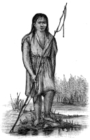
A SOCO LASS
The loquacious innkeeper at Charleston started us off with a comfortable breakfast and the information that the distance to Yellow Hill, the residence of Chief Smith and Cherokee seat of government, was about eleven miles, and from there to Waynesville, through Soco gap, was twenty-five. Two hours’ ride through the sandy, but well cultivated valley of the Tuckasege brought us to the Ocona Lufta. From this point the road follows the general course of the stream, but, avoiding its curves, is at places so far away that the roar of the rapids sounds like the distant approach of a storm. At places the road is almost crowded into the river by the stern approach of precipices, and then again they separate while crossing broad, green, undulating bottoms. Overtaking an old squaw and a girl probably ten years old, we inquired the distance to Yellow Hill. The old woman shook her head and gave us an expressionless look, indicating that she did not understand. The girl in good English gave us intelligible directions. We learned subsequently that nearly all the Cherokee children can speak and write English. Many of the old folks can understand our language, but will not admit it. I began asking some questions of a stoop-shouldered, heavy-set fellow about the country. He stood dumb, but when I told him I wanted to buy a few peaches his eye brightened, and the words “How many?” were distinctly uttered.
We arrived at Yellow Hill about 11 o’clock. Chief Smith resides in a comfortable house of four rooms, situated on top of an elevation in the midst of a plain of considerable extent. In an open yard near the house is a frame building used for a school-house, meeting-house, and council-house. We found Chief Smith in his residence, writing at a table covered with books, pamphlets, letters, and manuscripts. The room is neatly papered and comfortably furnished. The chief received us with cordiality. He was dressed in white starched shirt, with collar and cuffs, Prince Albert coat, well-fitting black pantaloons, and calf-skin boots shining like ebony. He is more than six feet tall, straight as a plumb line, and rather slender. His features are rough and prominent. His forehead is full but not high, and his thick, black hair, combed to perfect smoothness, hung down behind large protruding ears, almost to the coat collar. He has a deep, full-toned voice, and earnest, impressive manner. His wife is a white woman, and his daughters, bright, intelligent girls, have been well-educated. One of them was operating a sewing-machine, another writing for her father.
Under the present constitution the chief’s term of office is four years. His salary is $500 a year, and $4 a day additional when on business in Washington. No one but a Cherokee of more than 35 years of age is eligible to the chieftainship. There is an assistant chief who receives $250 yearly. He is one of the council, and in the absence of the chief performs his duties. There are in addition three executive advisers. The council consists of two delegates to every 100 persons. It is presided over by the chief, who has the veto power, but who is not at liberty to act in any matter of public policy without the authority of the council. Every male Indian over sixteen years old, and every white man who has an Indian wife, is allowed to vote. No one is eligible to office who has ever aided and abetted, or in any way joined the whites in defrauding the tribe; neither can any one hold office who denies the being of a God, or of a future state of rewards and punishments. There is general satisfaction with the present government, and Mr. Smith declares there is entire loyalty in all the settlements.
A public school is maintained, and even the old and middle-aged are better educated than the whites in many communities. The young are taught in both Cherokee and English. It is unfortunate that no public fund is provided for the advanced education of the more intelligent of them, that they might become teachers. Others should be placed in shops where they would become artisans. Finely engraved pipes, ornaments, and well made baskets show their capacity in this direction. Their industry at present is not commendable.
The christianization of the Cherokees was begun in 1801, by Moravian missionaries. It was easy to adapt their old faith to the new creed, and many were converted. Other churches have since taken up the work, Baptists deserving the most credit, and next to them the Methodists. They are naturally devout, and most of them are in regular communion with the church, thereby imposing marriage laws and other social regulations. Christianity has strengthened and solemnized the marriage tie, which in the prouder but more barbarous condition of the tribe was a very weak relation. Boys used to choose their wives at sixteen to eighteen years of age, live with them a few years and then abandon them and their families. It not unfrequently happened that after rioting with strange women for a period, they came back to their first choice, unless their places had been taken by others. Prostitution was common, though considered the most disgraceful of crimes, and punished by shearing the head. This punishment has been discontinued. Although there has been a healthy change in social morals there is room for improvement.
Rigid seriousness is a marked element of Indian character, and is written in unmistakable lines upon their faces. The Cherokee language is not capable of expressing a witticism, and anything like a joke is foreign to their nature. They have a great many so-called dances, but none of them, like the dance of the negro, is the effervescence of irrepressible joy. The Indian dances as a preparation for some coming event; he never celebrates. It seems to be a legacy of his heathen ideas of making sacrifice to the great spirit, apparently involving much painful labor. In the primitive days the whole tribe danced before making war, and the warriors danced before going into battle. It is still their custom to go through these melancholy perambulations before every contest of strength, such as a game of ball or a wrestling match. The funeral dance and the wedding dance are performed with the same stern immobility of features.
From Yellow Hill our party started to Qualla post-office, a collection of a half-dozen unattractive houses, inhabited by whites, but at one time the council house of the band. The Ocona Lufta crossed our path at the beginning. The purity of the stream seemed to forbid the intrusion of a dirty hoof, but there was no time to indulge sentiment. The ford is shallow, and angles down stream. My horse mistook a canoe landing, almost opposite, for his place of destination, his rider’s attention being absorbed in the blocks of many colored granite and transparent crystals of quartz, which form the bottom pavement. Three-fourths way across, the water was smooth and touched the horse’s neck. Another length, a plunge, and the horse was swimming; still the lustrous bottom shone with undiminished distinctness.
On our way through Quallatown to Soco creek, we passed numerous wayfarers carrying corn, fruit, baskets, and babies. One woman had a bushel of corn tied in a sack around her waist, a basket of apples on her head, and a baby in her arms. A slouchy man was walking at her side empty-handed and scolding, probably because she was unable to carry him. Under a peach tree before a cabin stood a witch-like squaw and half a dozen unattractive children. “Is this the Soco road?” was asked. “Satula” issued from her grim old mouth, and her finger pointed at the peaches.
“No, Soco; is this Soco?” nervously urged our companion, pointing up the stream.
“Uh,” she grunted out, and handed him one peach, from which we inferred that “soco” means “one.” A white woman in the vicinity confirmed our guess, and told us that “satula” is equivalent to the phrase “do you want it?”
Pause, and look at an “Indian maiden” by the road side. We did. Who, that has read Longfellow, and Cooper, and Irving, could pass without looking? She certainly could not have been the inspiration of Longfellow’s Hiawatha. She stands, in my recollection, with fishing rod in hand—about five feet tall, and 140 pounds in weight. Black, coarse, knotted hair hangs down her back to the waist. Under her low forehead is a pair of large, black eyes, which, unfortunately, are devoid of expression. Her cheek bones are wider than her forehead and almost touch the level of her eyes. A flat nose, straight mouth, and small ears, complete the physiognomy which showed no sign of thinking. Her neck is short and thick, and her shoulders broader than her broad hips. Her waist is almost manly. A gown of homespun, patched and dirty, half conceals her knees. With a glance at a large, but clumsy, pair of ankles, and flat feet, we pass on out of the Indian settlement along the rapids of Soco. We had not been approached by a beggar, or asked to buy a penny worth of anything during the whole day.
The scenery along the torrents of Soco creek, down the western slope of the Balsams, rivals in variety and picturesque effect that of any place in the Appalachians. There are no grand chasms, nor grand cascades. There is nothing, indeed, which calls for superlative adjectives, unless, possibly, we except the immensity of the trees, the unbroken carpeting of moss, and the perfect grace of tall ferns. There is, in the curves of the torrent, as it bounds over precipices and down rapids, compelling us to cross its noisy channel at least twenty times; in the conformation of the glens through which we rode; in the massiveness and towering height of the great chain, up whose side we were climbing; in the white fragments of rock, which reflect the sun light from the stream’s channel and the highway; in the rounded cliffs, so modest that they keep themselves perpetually robed in a seamless vesture of moss; in the ferns, the shrubs, the trees, in the absolute solitude and loneliness of the place,—there is something so complex in its effect upon the interested student of nature that he is unwearied by the two hours and a half required to make the ascent.
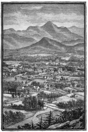
MOUNT PISGAH.
West Asheville in the Foreground.