Mound D
Reading edition
This low circular mound was located on the south bank of Cypress Creek about 150 feet east of Mound A (Fig. 1). It was perched at the very edge of the floodplain overlooking the creek channel. In recent years the channel had been migrating laterally and had begun to encroach on the north edge of the mound. The average diameter of Mound D at the base was about 60 feet, and its highest point was at a relative elevation of 100.6 feet, or about 2.5 feet above the surface of the surrounding floodplain (Fig. 9). A shallow depression about 12 feet across in the top of the mound marked the location of the usual pothole. This pothole had originally been only 5 to 6 feet in diameter, but had been considerably enlarged at the surface of the mound by recent erosion.
Excavation of Mound D was begun shortly before the end of the 1958 field season. It was dug, like the other mounds, by the quadrant method; but, because there was not enough time for thorough excavation, only the southwest quadrant was carried down to the sub-mound level in 1958. The other three quadrants were taken down to the 98-foot level, however, where a circular zone of dark, organically stained soil, 19.8 feet in diameter, clearly outlined the location of a house structure (House No. 4) similar to those at Mounds B and C. During the final work at Harroun in February, 1959, the entire northwest quadrant was exposed, excavated, and recorded. Only the peripheral ring of post molds was exposed in the other two quadrants.
The southwest quadrant of the mound was excavated in 0.5-foot levels; all other portions were taken down in 1.0-foot levels. Horizontal plans were recorded at all levels and photographs were taken. Vertical walls 1.5 feet thick were preserved across the mound along the W100 and N100 lines (Fig. 9), and trenches three feet wide were extended north, south, and west of the mound in order to obtain complete vertical profiles. Excavation and recording methods were generally the same as previously described for the other mounds.
33
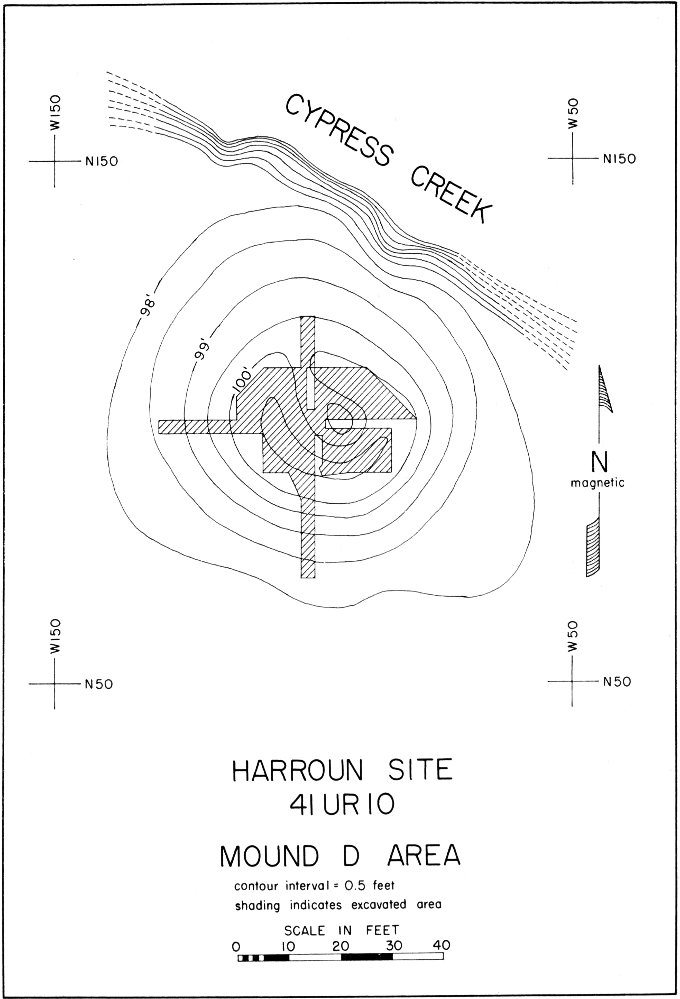
Fig. 9
HARROUN SITE: 41 UR 10 MOUND D AREA CYPRESS CREEK
34
STRUCTURE OF MOUND D
The structure of Mound D was clearly indicated by the vertical cross sections (Fig. 7). An old humus-stained surface underlying the marginal portions of the mound was sharply defined at an average elevation of 98.0 feet. No artifacts or cultural refuse were found in the floodplain below this surface. Prior to construction of the mound a shallow, circular pit had been excavated in the surface of the floodplain to an average depth of 1.5 feet. The sides of the pit sloped sharply downward, and the floor was approximately level. An embankment of yellow-brown sand, possibly composed of back-dirt from the pit, was mounded up about 1.5 feet high and four to six feet wide around the perimeter of the pit. This light sand zone contained a few artifacts but little or no charcoal.
A hard-packed house floor about 0.2 feet thick lay on the bottom of the pit. This floor zone was composed of compact sandy clay which contrasted sharply with the overlying mound fill. Charcoal, ash, and burned clay daub were found in quantity in the floor zone, but only a few artifacts were recovered. Just above the house floor was a 1-foot thick layer of dark gray-brown sand containing several charred poles and a large amount of charcoal, ash, and burned clay daub. Above that was the sandy fill making up the bulk of the mound. A mantle of surface humus from 0.2 to 0.8 feet thick covered the mound.
A ring of post molds was discovered around the edge of the floor, and other molds on the west side of the house marked the position of an extended entranceway (Fig. 10). No interior post molds were discovered.
The pothole, which extended downward through the center of the floor, had apparently removed a centrally located hearth, only slight evidence of burning at the edge of the pothole remaining to show that the hearth had been there.
The entire mound fill, including the embankment around the house, was composed of various shades and textures of sand. All of this material was probably derived from the sandy floodplain surrounding the mound. Small quantities of clay around the hearth and on the house floor could have been acquired at nearby outcrops in the stream channel.
As at Mounds B and C, the circular shape of the house at Mound D was outlined by an area of organically stained soil which extended upward 35 from the house floor almost to the surface of the mound. The flanks of all three mounds were of light colored sand which contrasted sharply with the dark, circular house outlines. The only reasonable conjecture thus far advanced to explain this circumstance is that a low embankment of relatively clean sand had been piled against the exterior wall of each house. Thus when a house burned the embankment would remain standing, well above the house floor, as a sort of mold of the lower portion of the house. Then when a mound was erected over the burned house remains and the standing embankment, the outline of the house might appear in the mound fill as a cast of the house, delineated by the circular embankment.
OCCUPATIONAL FEATURES
House No. 4 was the only occupational feature discovered at Mound D.
House No. 4
This house was circular in shape, with an exterior wall formed of upright poles, wattle, and clay daub. Post molds indicated that there were at least 27 of the upright poles in the exterior wall (Fig. 10). They were 0.3 to 0.6 feet in diameter at the base and were set about two feet apart on an average. An interior hearth near the center of the house was probably circular in shape and an estimated three to four feet in diameter. Its exact dimensions could not be determined because of disturbance by the pothole. No interior post molds were found.
Remains of an extended entranceway on the west side of the house consisted in five post molds which outlined the two parallel sides of the entranceway. The entranceway was slightly less than three feet wide, and it sloped downward from the surface of the floodplain into the house pit.
Burned poles and burned clay daub with wattle impressions showed that House No. 4 had been destroyed by fire.
DISCUSSION
Investigation of Mound D revealed that the following sequence of events had taken place. A round, Caddoan type of house (House No. 4) with an extended entranceway on the west side was built in a shallow, excavated pit on the south bank of Cypress Creek. Architecturally the house was quite similar to those at Mounds B and C. Sand was probably banked against the outside wall of the house to a height of somewhat more than a foot. After an unknown period of time the house was destroyed by fire, and then the house remains and the surrounding embankment of sand were buried beneath a mound of sandy soil. This duplicates essentially the events reconstructed for Mounds B and C, the only unique feature at Mound D being the pit in which the house was built.
36
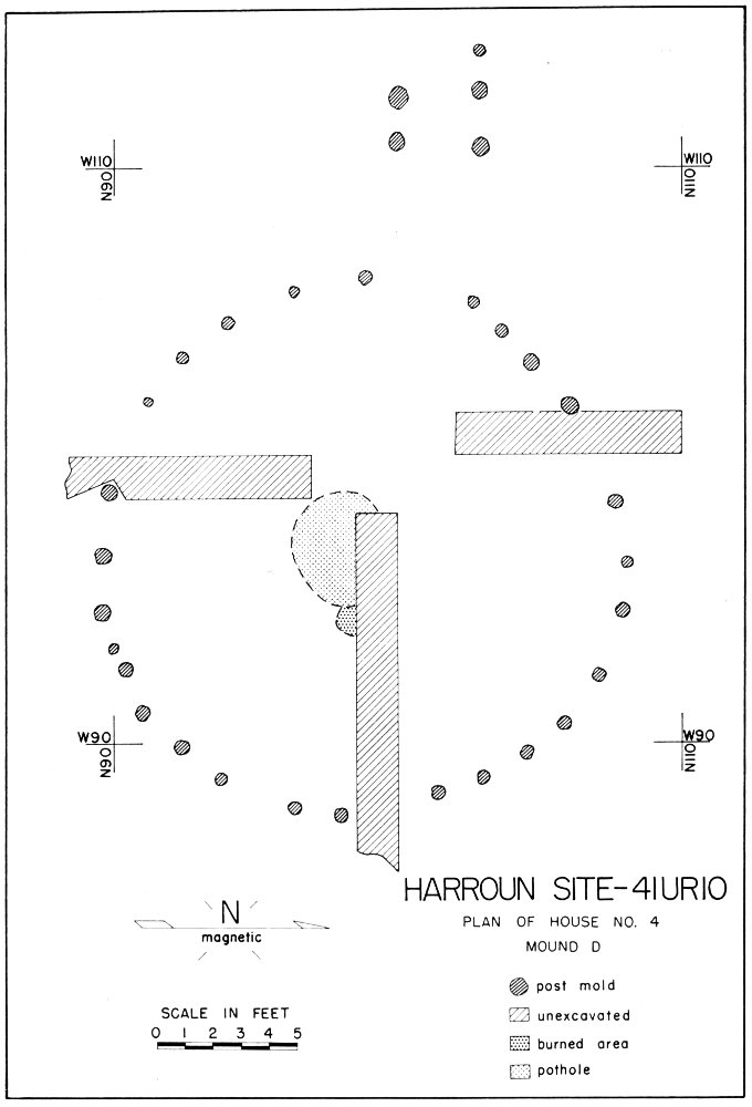
Fig. 10
HARROUN SITE 41 UR 10 PLAN OF HOUSE NO. 4 MOUND D post mold unexcavated burned area pothole
37
Probable ceremonial burning, burial beneath a mound, and a scarcity of domestic artifacts and refuse suggest that House No. 4 was not an ordinary residence, but a small temple, chapel, or similar structure used for ceremonial purposes.
38