Mound C
Reading edition
Mound C was situated on the west bank of the lake, 350 feet northwest of Mound B (Fig. 1). This mound was in the shape of a broad oval with its long axis oriented in an east-west direction. It measured 62 by 52 feet at the base and reached a maximum elevation of 102.6 feet, or slightly more than three feet above the modern surface of the floodplain (Figs. 6 and 11, B).
There was a circular depression approximately nine feet in diameter in the top of the mound where pothunters had been at work. Excavation revealed that the pothole had been dug to a depth of 4.8 feet and had later been partially filled by natural agencies. Unfortunately, the pothole had destroyed most of the central hearths associated with the two house floors found at the base of the mound.
After the trees and bushes had been cleared from Mound C the standard grid of 5-foot squares was established with a base stake set 125 feet south and 100 feet west of the approximate center point of the mound. The initial step in excavating the mound was to dig the southwest quadrant down to elevation 100.0 feet. Next, the southeast quadrant was excavated to the same level so that an east-west profile remained standing completely across the mound. After the profile had been studied and recorded, the other two quadrants were removed and the entire mound was levelled at elevation 100.0 feet, where a circular zone of dark soil containing a large amount of charcoal marked the outline of what later proved to be the remains of two houses, one superimposed on the other.
A narrow east-west trench was next dug across the house area, the north edge of the trench being on the N125 line so that it matched the bottom of the major east-west profile which had already been removed. This trench revealed two thin layers of dark midden soil, each of which represented the floor level of a house (Fig. 7). The two floor levels were separated by a layer of clean, yellow sand. The lower floor rested on undisturbed soil at the base of the mound. Numerous charred segments of poles lay in a jumble on and just above the upper floor as though the house walls had burned and collapsed.
24
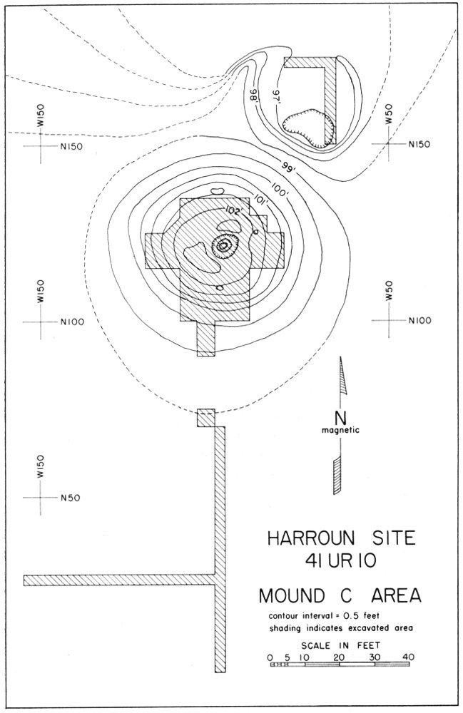
Fig. 6
HARROUN SITE 41 UR 10 MOUND C AREA contour interval = 0.5 feet shading indicates excavated area
25
The house floors were completely excavated, the artifacts and other material associated with each floor being collected and sacked separately wherever possible. Two concentric rings of post molds at the periphery of the house area were exposed and recorded, as were several interior post molds (Fig. 8). An entrance passageway was delineated at the west side of the house area.
In order to determine the relationship of the mound to the floodplain several short trenches were carried from the edge of the mound out into the floodplain formation (Fig. 6). A depressed area in the surface of the floodplain between the mound and the lake was also trenched in an effort to determine whether it may have been a borrow pit. Several other trenches were dug south and west of the mound in an unfruitful search for any middens, houses, burials, or other occupational features that might have been located near the mound.
Throughout the excavation of Mound C, major profiles, horizontal plans at ½-foot intervals, and occupational features were described in the field notes and drawn to scale. Major profiles and features were photographed. Most of the digging was done with shovels, but trowels were used in part for excavating the two thin floor zones and for several other situations where close attention to detail was desirable. Because of time limitations only representative, spot screening was attempted.
STRUCTURE OF MOUND C
Profiles of Mound C revealed remnants of an old stabilized surface with a well developed soil profile (including a superficial humic zone) lying immediately beneath the mound fill (Fig. 7). The elevation of the old surface averaged approximately 99.4 feet which is also the average elevation of the modern floodplain surface around the mound: therefore it appears certain that the first of the two houses was built directly on the floodplain surface and that there has been no appreciable change in the surface elevation of the floodplain since the mound was built. The first house burned, after which the second house was built over its remains; then the second house burned and the mound was erected over the ruins of the houses.
26
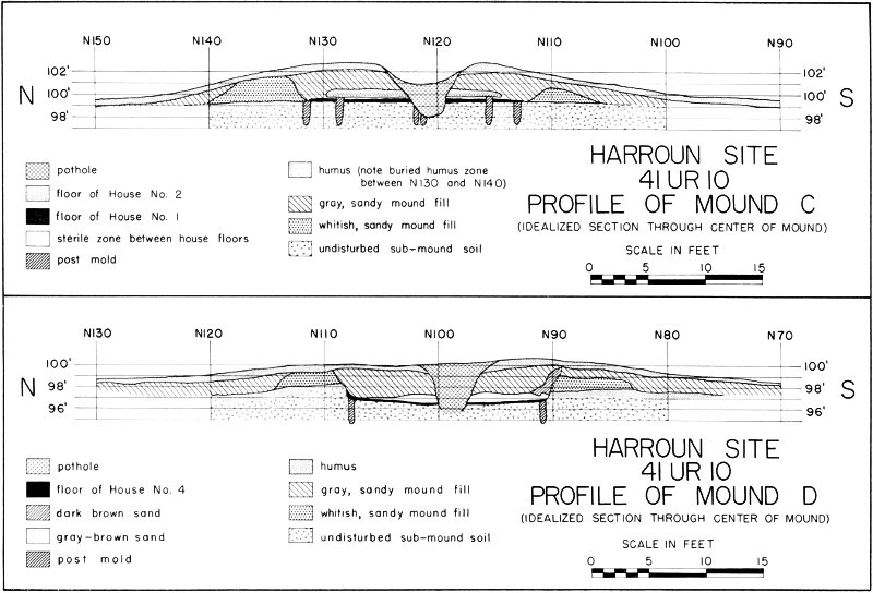
Fig. 7
HARROUN SITE 41 UR 10 PROFILE OF MOUND C (IDEALIZED SECTION THROUGH CENTER OF MOUND) pothole floor of House No. 2 floor of House No. 1 sterile zone between house floors post mold humus (note buried humus zone between N130 and N140) gray, sandy mound fill whitish, sandy mound fill undisturbed sub-mound soil
HARROUN SITE 41 UR 10 PROFILE OF MOUND D (IDEALIZED SECTION THROUGH CENTER OF MOUND) pothole floor of House No. 4 dark brown sand gray-brown sand post mold humus gray, sandy mound fill whitish, sandy mound fill undisturbed sub-mound soil
27
A low embankment of sand similar to that at Mound B encircled the house area just outside the peripheral ring of house post molds (Fig. 7). Apparently this embankment was built while one of the houses was still standing since its inner edge is almost vertical in places as though it had been banked against the outside wall of the house. After the later house burned, the mound was heaped over both this embankment and the house ruins.
The geologic structure of the floodplain at Mound C was apparently the same as previously described although none of the excavations were carried deep enough to expose Zone I, the basal member of reddish clay. The mound structure rested on the surface of Zone IIc (Fig. 7) and was composed of four distinct structural units as follows (in order from bottom to top):
1. The lower house floor zone (House No. 1). This zone was composed of blackish sand containing a large amount of charcoal and had an average thickness of about 0.3 feet. It yielded some artifacts. This lower house floor lay just above the surface of Zone IIc (the floodplain surface) from which it was separated by a thin (approximately 0.1-foot thick) lens of compact sandy clay. The thin clay lens was apparently a subsurface formation resulting from the deposition of clay by percolating water along the buried surface of the floodplain.
2. The upper house floor (House No. 2). This zone consisted of a slightly compacted, brownish sand containing a large amount of charcoal and a few artifacts. It lay above the floor of House No. 1, and was separated from it by a layer of clean, sterile, yellowish sand 0.1 to 0.3 feet thick which probably was placed over the burned ruins of the first house to provide a clean floor for the second one.
3. The embankment of yellow-brown sand encircling the house area. As was previously pointed out, this member had the appearance of having been banked against the exterior wall of the house while it was still standing. Perhaps this provided extra protection from the winter winds, or its primary purpose may have been to serve as a dike to protect the house when Cypress Creek overflowed its banks. The maximum height of this zone was 2.0 feet above the surface of Zone IIc, upon which it rested.
4. The final addition to the mound. This was the sand member which 28 had been mounded over the house ruins. It was virtually sterile of cultural material.
OCCUPATIONAL FEATURES
The only occupational features discovered at Mound C were the two house patterns.
House No. 1
The lower house floor at Mound C, designated House No. 1, rested directly on the old surface of the floodplain (Fig. 7). The floor zone was a circular lens of dark gray—almost black—sand with a greasy texture. It averaged 0.4 feet in thickness and measured some 18 feet across. This floor zone contained numerous bits of charcoal and burned clay daub, a few stone chips, mussel shells and garbage bones, and a small number of artifacts.
Around the perimeter of the floor was a ring of post molds representing the exterior house wall (Fig. 8). Average diameter of the ring was 18 feet. Each post mold extended downward below the floor level into the sub-mound floodplain. The individual molds ranged from 0.35 to 0.75 feet in diameter, the bottoms being from 1.3 to 2.0 feet below the floor level. There was a total of 29 definite molds plus one probable mold in the peripheral ring, and disturbances on the west and south sides of the house appeared to have obliterated at least five others. The posts had been set about 1.5 to 2.0 feet apart on an average. Time did not permit vertical sectioning of all the molds, but several were carefully sectioned and studied to determine the level from which they had been dug. All began at the floor of House No. 1, none extending above that level.
The large pothole observed in the top of the mound continued downward entirely through the floor of House No. 1, although it had narrowed to a diameter of less than four feet where it intercepted the floor (Fig. 8). Unfortunately the pothole had destroyed the major portion of a centrally located hearth that must have been associated either with House No. 1 or the overlying House No. 2. Actually, there was probably a hearth for each house, the later one constructed directly above the earlier one. But since only a narrow segment of burned soil remained to mark the eastern margin of the hearth (or hearths), the structural details could not be ascertained. As nearly as could be estimated by the surviving portion of the hearth, it must have been approximately three feet in diameter.
29
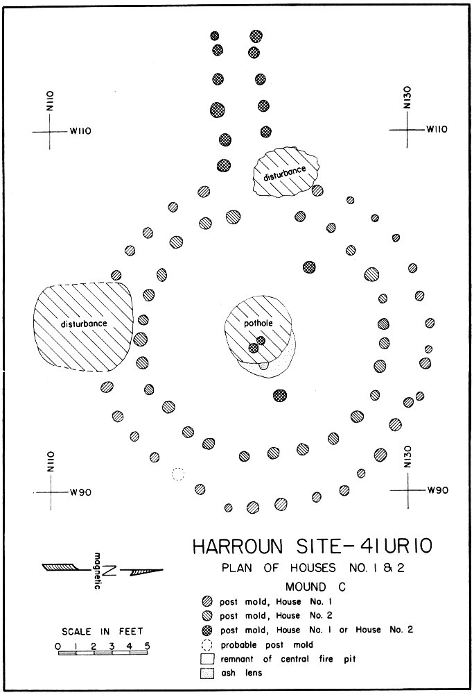
Fig. 8
HARROUN SITE 41 UR 10 PLAN OF HOUSES NO. 1 & 2 MOUND C post mold, House No. 1 post mold, House No. 2 post mold, House No. 1 or House No. 2 probable post mold remnant of central fire pit ash lens disturbance disturbance pothole
30
Beneath the pothole—which luckily terminated a foot or so below the floor of House No. 1—were the bottom portions of two post molds (Fig. 7). These were undoubtedly from the center posts used during construction of Houses No. 1 and 2. Although the exact circumstances could not be reconstructed because of disturbance, the center posts presumably were removed when the houses were completed and the hearths placed over the molds.
In addition to the two center molds, there were two other post molds within the interior of the houses at Mound C. One was just east of the hearth area, the other was northwest of the hearth (Fig. 8). Both were exposed in the excavation floor at the level of House No. 1, and since they were not encountered above that level both probably relate to the earlier house.
An extended entranceway on the west side of the houses was delineated by an elongated area of organically stained soil and by two parallel rows of post molds (Fig. 8). The stained area was clearly discernible in the mound fill above both house floors. Despite extremely careful excavation of this stained area, however, only the bottom portions of the post molds—well below the floor level of House No. 1—could be seen. Consequently the level from which the entranceway post holes were dug could not be determined and it is uncertain to which of the two houses they belonged. House No. 2 must have had its entranceway on the west side because the organically stained outline showed clearly in the mound fill well above the House 2 floor level. Possibly both houses had their entranceways in this same area.
House No. 2
House No. 2 was represented by a distinct floor zone and by a circle of post molds. The floor zone (Fig. 8) consisted of a lens of brownish sand averaging about 15.5 feet in diameter, with a maximum thickness near the center of almost a foot. It lay directly above the floor of House No. 1, but was separated from it by a thin layer of clean, sterile sand 0.1 to 0.3 feet thick. The sterile sand layer was possibly placed over the burned ruins of House No. 1 in order to provide a clean floor for House No. 2.
31
The peripheral ring of post molds (Fig. 8) averaged a little less than 14 feet in diameter (or almost four feet less than that of the underlying House No. 1) and lay entirely inside the exterior wall of House No. 1. The two rings were not quite concentric, however, the center point of House No. 2 being slightly to the west of the center point of House No. 1. The post molds of House No. 2 were from 0.45 to 0.85 feet in diameter, and they extended from 1.6 to 2.0 feet below the level of the related house floor. Several of the molds were sectioned vertically to determine the level from which they had been dug. They could be clearly traced from the floor of House No. 2 down through the floor of House No. 1 into the sub-mound floodplain.
As was pointed out above in the description of House No. 1, there was probably a circular, centrally located hearth associated with House No. 2, and one of the two center posts whose molds were found beneath the hearth area must have been used in the construction of the later house. There appeared to be no other interior post molds associated with House No. 2. The entranceway was probably on the west side.
DISCUSSION
Excavation of Mound C revealed that a circular house (House No. 1) was built on the south bank of the Harroun Site lake, was occupied for an unknown period of time, then was burned—perhaps intentionally. After a thin layer of sand had been strewn over the burned ruins, a second, smaller house (House No. 2) was erected on the remains of the earlier house. House No. 2 was likewise destroyed by fire, after which the remains of both houses were buried under a mound of sand.
Both houses probably had centrally located hearths, and one or both of them had an entranceway opening to the west. As at Mound B, a low pile of sandy soil may have been banked around the outside of one or both houses before they were destroyed. Architecturally the houses at Mound C were quite similar to the one at Mound B.
The sparse occurrence of artifacts and other cultural refuse suggests that neither House No. 1 nor House No. 2 was an ordinary domicile. It appears likely, rather, that both were ceremonial structures of some sort. This hypothesis is supported by the fact that the houses were considered important enough to be afforded burial beneath a mound, probably after having been ceremonially “cremated.”
32