Mound B
Reading edition
This low, approximately circular mound was located on the floodplain of Cypress Creek, about 125 feet south of the stream channel, at the south end of the lake (Fig. 1). A shallow depression about eight feet across lay just southwest of the mound, and a similar but smaller depression was recorded at the northeast edge of the mound. These features probably are borrow sources. An intrusive pothole, located near the center of the mound, was three to four feet in diameter at the surface, but fortunately it proved to be quite shallow and damage to the mound was slight. The maximum diameter of Mound B, measured north-south, was 55 feet (Fig. 4), and the mound reached a maximum height of 2.8 feet above the floodplain.
Mound B was staked for excavation with the usual grid of 5-foot squares oriented on magnetic north. The base stake was 100 feet south and 100 feet east of the approximate center of the mound. Excavation was carried out by the quadrant method as previously described, the southeast and northwest quadrants being excavated first, the southwest and northeast quadrants last. Each quadrant was taken down by ½-foot levels which were keyed to the vertical reference datum. In addition to work in the mound itself, the area immediately south of the mound was tested by means of trenches (Fig. 4). The trenches were dug in ½-foot levels measured from the surface of the floodplain at each square.
The excavating and recording methods used at Mound B were generally the same as described for Mound A.
STRUCTURE OF MOUND B
The excavations in Mound B revealed clearly its internal structure (Fig. 3). An old soil surface, unmistakably defined by a dark humic zone, underlay the entire mound at an average elevation of 99 feet, or approximately the same elevation as the modern surface of the floodplain. This evidently represents the surface humic zone (Zone IIc) of the floodplain at the time the mound was built. Yellow-brown sand (Zone IIb) extended below the buried humic zone to an undetermined depth. Zones IIb and IIc beneath the mound contained a few scattered stone chips and an occasional artifact, but there were no concentrations of cultural material.
18
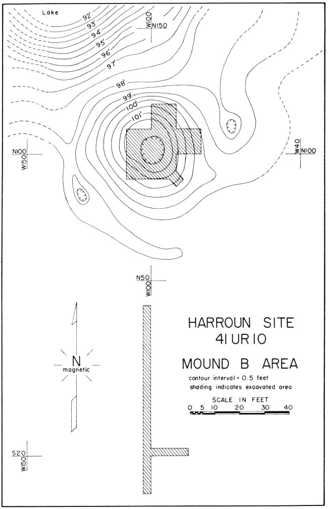
Fig. 4
HARROUN SITE 41 UR 10 MOUND B AREA contour interval = 0.5 feet shading indicates excavated area
19
Resting directly on the old floodplain surface was the basal structural component of the mound, a rather compact, circular lens of dark brown sand up to a foot or more thick and averaging about 17 feet in diameter. This lens, which contained abundant charcoal, burned clay daub, bone, shell, and a few artifacts, represented the floor level of a house, designated House No. 3. In and above the floor level were the remains of several charred poles, presumably derived from the burned framework of the house. A burned area approximately four feet in diameter in the center of the lens proved to be the remains of a central fire hearth. It was filled with complex lenses of various shades and textures. A large post mold was found beneath the hearth in the approximate center of the house.
Completely encircling the house outline was a poorly defined zone of yellow-brown sand which lay directly on the buried surface of the floodplain and extended upward a foot or two where it gradually blended into the upper component of the mound fill. This light-colored sand may have been banked against the outside of the house while it was still standing; or it may have resulted from uneven, subsurface staining by charcoal and other organic material of that portion of the mound lying directly above the house. In any event, it was virtually devoid of cultural material, only a very few stone chips, widely scattered, being found in it.
A well defined humic zone, resulting from organic staining after the mound was built, appeared at the surface of the mound. It averaged about 0.5 feet in thickness.
Except for the clay in the hearth and in the house floor, the entire mound was constructed of sandy soil like that of the surrounding floodplain, whence it undoubtedly was derived. The depressions on the northwest and southeast sides of the mound are probably the borrow sources for the sandy soil. The clay could have easily been obtained from exposures in the cut banks at the edge of the creek channel.
20
OCCUPATIONAL FEATURES
Besides the two possible borrow pits mentioned above, the only occupational feature found at Mound B was House No. 3.
House No. 3
This house was erected on the surface of the floodplain before the mound was built. The purpose of the mound apparently was to bury the remains of the house after it had burned.
Beneath the house floor zone, which was described in the preceding section, were found 59 post molds measuring from 0.25 to 1.3 feet in diameter and extending from 0.3 to 2.5 feet below the floor (Fig. 5). The faint gray stain of the post molds was quite dim and difficult to distinguish. They were located by cutting a vertical face completely around the house area, then carefully cutting the face inward from all sides. As the post molds were located, they were plotted on a horizontal plan and a measured profile drawing of each was prepared.
Twenty-three of the post molds formed a circular outline representing the perimeter of a house approximately 17 feet in diameter (Fig. 5). The peripheral molds averaged 0.5 feet in diameter and were spaced, as a rule, about two feet apart. At the southeast edge of the house were two parallel lines of three molds each which defined an extended entranceway. Because of disturbance in the entranceway area by tree roots, only the bottom portions of the entrance molds were preserved. Their arrangement suggests that some of the post molds related to the original entranceway were not discovered.
Within the external ring of post molds were 30 irregularly spaced molds, including four very large ones which probably held the bases of relatively heavy roof supports. Two concentrations of smaller post molds (one on the northeast side of the house, the other on the southwest side) possibly mark the location of interior structures such as sleeping or storage platforms. In the center of the house was a relatively large post mold, over which the fire hearth had been built. This probably represented a center post used in construction of the house and then removed when the house was completed.
The hearth was located in a shallow depression at the center of the house. It was in the form of a basin about four feet in diameter and one foot deep. The sandy soil underlying the hearth had been burned to a deep reddish color.
21
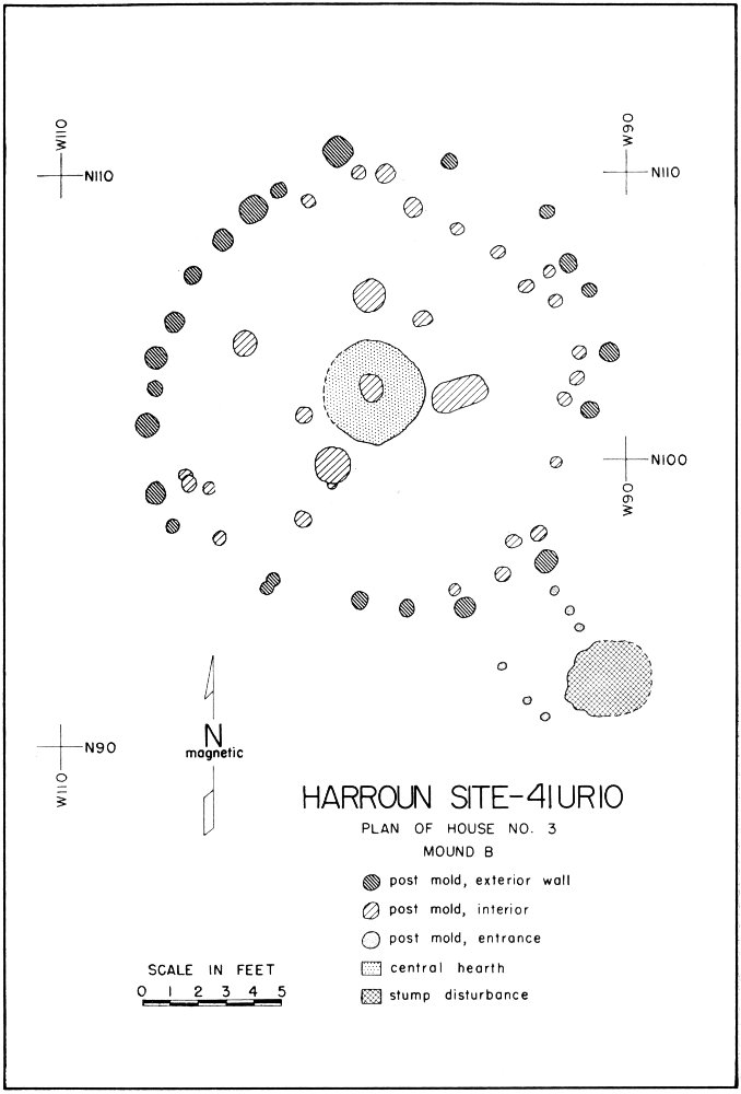
Fig. 5
HARROUN SITE 41 UR 10 PLAN OF HOUSE NO. 3 MOUND B post mold, exterior wall post mold, interior post mold, entrance central hearth stump disturbance
From all indications this house was constructed in a manner similar to that described by early Spanish and French explorers in the Caddoan Area (Swanton, 1942: 148-154). A ring of poles, each with its base end set in a deep hole, was placed in upright position around a tall center 22 post used as a work platform. The tops of the poles were drawn together at the center and bound. Small tree branches were then woven, horizontally, between the upright poles, grass thatching was applied, and, in some cases, the exterior was plastered with a coat of clay mud. (Many pieces of burned clay daub, some bearing impressions of sticks and grass, were found on and above the floors of all the houses at the Harroun Site.) After the house was completed, the center post, used only to facilitate construction, was removed. Interior support posts may have been added, and platforms for sleeping or storage were built inside the house.
DISCUSSION
House No. 3, a circular, wattle-and-daub structure with a southeastern entranceway, was built on the surface of the Cypress Creek floodplain. There were probably four interior roof support posts, two or more interior platforms for sleeping or storage, and a centrally located, prepared hearth with a clay base. Possibly, a low embankment of sand was thrown against the wall around the exterior of the house.
The period of occupation at the house is unknown, but the scarcity of artifacts suggests that it was of short duration, or else that it was used for specialized—perhaps ceremonial—purposes. A domiciliary structure ordinarily would have much more cultural refuse about it than did House No. 3, unless it was occupied for only a very brief period of time. Stone chips and a few artifacts in the floodplain beneath the house floor indicate that the spot had been lightly occupied prior to the construction of the house.
That House No. 3 burned is evident from the charred poles and bits of heavily burned, wattle-impressed, clay daub lying on and above the house floor. Shortly after the burning, a mound of sandy soil, undoubtedly derived from the adjacent surface of the floodplain, was heaped over the house ruins.
Burial of the house remains beneath a mound implies that the house had a special significance, possibly of a ceremonial nature. Consequently it may be conjectured that perhaps House No. 3 was a small temple or chapel which was ceremonially burned and buried.
23