Mound A
Reading edition
Mound A, the smallest of the four mounds, was situated 75 feet south of Cypress Creek and 100 feet west of Mound D (Fig. 1). It was roughly oval in shape with the long axis running due east and west (Figs. 2 and 11). The length at the base was 35 feet; the basal width was 28 feet. The maximum height above the modern floodplain was approximately two feet. No potholes or other disturbances were evident from the surface.
10
After several trees and bushes had been cleared away, the Mound A area was staked on a grid of 5-foot squares. A stake near the base of the mound on the south side was arbitrarily selected as the base or 0-0 stake, and the designations for the other stakes were determined by measuring their distance from the base stake in terms of the cardinal directions. The elevation of the ground surface at the 0-0 stake was assigned an arbitrary value of 100.0 feet, and all vertical measurements for the entire site were keyed to that point.
As an initial test, most of the southwestern quadrant of the mound was excavated to undisturbed sub-mound soil so that two radial profiles were left standing, one running south, the other west, from the approximate center of the mound. Since time did not permit complete excavation of Mound A, the only squares excavated in the remaining three quadrants were the three 5-foot squares cornering on the approximate center point of the mound and square N10-E5 which was excavated in order to expose Burial No. 1 (Fig. 2). Two additional 5-foot squares (N15-W40 and S25-E0) beyond the limits of the mound structure were carried down several feet below the surface of the floodplain. Each of the latter squares was aligned with one of the two major profiles radiating from the center of the mound. A 1-foot wide check strip, running east-west along the N20 line, was left standing.
All squares were dug in 0.5-foot levels. Those squares in the mound structure were leveled successively on each ½-foot interval of the vertical reference system, while the two squares dug into the floodplain near Mound A were dug by 0.5-foot levels measured from the surface of the ground. All the soil from squares N15-W40 and S25-E0, and an estimated 50% of the excavated mound fill from other squares, was screened through hardware cloth of ¼-inch mesh. All digging was done with shovels except for close work around Feature No. 1 and Burial No. 1 where trowels were used.
In the mound, horizontal plans were drawn to scale at 0.5-foot intervals as the squares were leveled, all features, soil changes, and major disturbances being recorded. Representative profiles were also drawn to scale so as to provide a record of the mound structure and of the relationship of the mound to the floodplain on which it rested.
The major profiles, the burned area near the center of the mound (Feature No. 1), and the sub-mound burial (Burial No. 1) were photographed in both color and black and white.
11
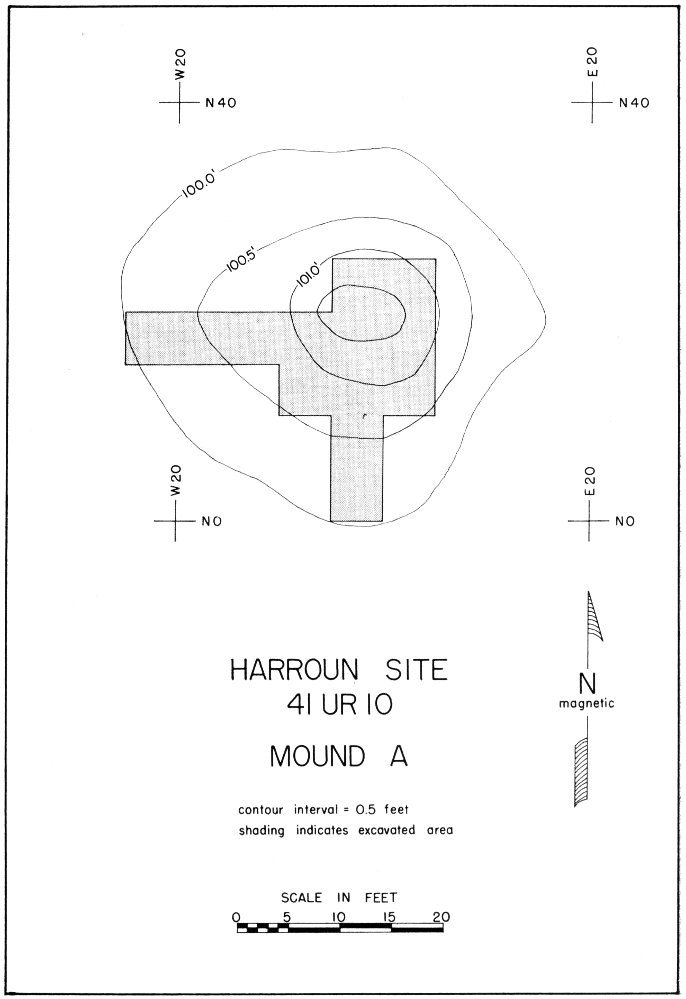
Fig. 2
HARROUN SITE 41 UR 10 MOUND A contour interval = 0.5 feet shading indicates excavated area
12
STRUCTURE OF MOUND A
The profiles revealed that the bulk of the mound fill comprised a single structural member composed of dark gray, humus stained, sandy, midden soil (Fig. 3). It reached a maximum height of 1.4 feet above the surface of the surrounding floodplain and extended down to an average depth of 1.4 feet below the floodplain surface. The fill of Mound A contained many tiny fragments of mussel shell, bone, charcoal, and stone chips, as well as a few potsherds, projectile points, and other artifacts. Some of the shell and bone fragments showed evidence of burning. The mound fill was unquestionably derived from an occupational area containing an appreciable quantity of cultural detritus.
The top of soil Zone IIb in the area surrounding the mound was, on an average, about 0.7 feet below the surface of the floodplain. The bottom of the mound structure, however, extended to an average depth of 1.4 feet below the floodplain surface where it terminated within Zone IIb (Fig. 3). Thus the surface of Zone IIb immediately beneath the mound formed a shallow, saucer-shaped depression which must have resulted from digging away of the topsoil before the mound was erected. This shallow pit (perhaps originally 1.0 to 1.5 feet deep) was approximately the same size and shape as the base of the mound.
OCCUPATIONAL FEATURES
Besides the mound itself, two occupational features were found in the Mound A area: (1) an area of burned soil within the mound fill (Feature No. 1), and (2) a sub-mound burial (Burial No. 1). Each is described separately below.
Feature No. 1
This was an elongated area of heavily burned, sandy clay lying within the matrix of the mound fill (Fig. 3). Since the northern end of Feature No. 1 was not completely excavated, the exact dimensions were not determined; but the maximum length was evidently between 9 and 10 feet, while the maximum width was 4.3 feet. The long axis ran approximately north-south. Profiles revealed a lenticular cross section with a pronounced thickened area near the mid-point of the east edge. Near the center the burned zone was 0.5 feet thick; the thickened area near the east edge reached a maximum thickness of 1.5 feet.
13
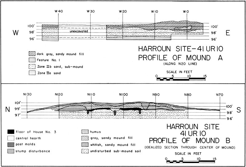
Fig. 3
HARROUN SITE—41UR10 PROFILE OF MOUND A (ALONG N20 LINE) dark gray, sandy mound fill Feature No. 1 Zone IIb sand, sub-mound Zone IIa sand
HARROUN SITE 41UR10 PROFILE OF MOUND B (IDEALIZED SECTION THROUGH CENTER OF MOUND) floor of House No. 3 central hearth post molds stump disturbance humus gray, sandy mound fill whitish, sandy mound fill undisturbed sub-mound soil
14
The surface of Feature No. 1 was burned to a conspicuous degree of hardness and was sharply demarcated from the soft, unfired mound fill which overlay it. Beneath the central portion, heat had produced a thin zone of reddish sand which merged gradually with the underlying grayish sand of the mound fill.
Feature No. 1 was situated in the lower portion of the body of the mound. It did not have the appearance of a carefully prepared hearth, but the presence of clay in the burned soil suggests that an irregular-shaped clay base had been laid down where the fire was to be built. It appears that after a layer of sand about a foot thick had been piled up to form the base of the mound, further work on the mound was temporarily interrupted, a crude hearth of sandy clay was prepared near the center of the basal layer of sand, and a fire of considerable intensity was kindled on it. The hardness of the burned, sandy clay of the hearth indicates that the fire was quite a hot one and that it must have burned—continuously or intermittently—for a period of many hours at least. After an unknown interval of time the fire was extinguished and the construction of the mound was resumed and carried to completion. The sharp definition of the hearth surface and the homogeneity of the mound fill above and below the hearth indicate that no appreciable time elapsed between the extinguishing of the fire and the addition of the upper part of the mound fill: otherwise the surface of the hearth should have shown evidence of weathering and the two different stages of mound construction should have been visible in the profiles as separate zones.
Burial No. 1
Beneath the southeast quadrant of Mound A a single burial was found (Fig. 12, A). The skeleton lay in extended, supine position, with the head to the northeast and the feet to the southwest. Preservation of the bones was poor, and several of them (including the left femur, most of the arm and hand bones, the lumbar vertebrae, and the foot and ankle bones) had been destroyed or displaced by gophers whose runs interlaced the entire burial area. As a result of this disturbance the original position of the arms could not be determined.
Two pottery vessels—a carinated bowl and a bottle, both of the type Ripley Engraved (Fig. 12, B-C) had been placed beside the left hip as burial offerings, and an arrow point of the Perdiz type (Fig. 15, O), 15 lying near the outer side of the left knee, appeared also to have been included intentionally with the burial.
The first evidence that a burial was present was the discovery of several foot and ankle bones in a rodent run in square N10-E0. The burrow was traced toward the north for several feet where the distal end of a human tibia was exposed in the northeast corner of square N10-E0. Since it was apparent that the major portion of the burial lay in square N15-E5, that square was taken down. At 0.5-foot intervals the floor of the square was scraped clean with trowels and carefully examined for evidence of a grave outline. However, none was detected in the mound fill.
The burial was finally exposed at a depth of 3.6 feet below the surface of the mound, the floor of the grave lying at an average depth of 1.0 feet below the base of the mound. A vague area of discolored soil (which contrasted faintly with the surrounding undisturbed IIb sand) marked the location of the lower portion of the grave. The edges of the burial pit were quite indefinite, having been considerably disturbed by roots and rodents, but its appearance—both in flat plan and in profile—suggested that a shallow grave about a foot deep and just large enough to accommodate the body had been dug from the floor of the shallow sub-mound pit, the body had been placed in the grave, and then earth had been heaped over both the body and the shallow pit to form the mound.
The skeletal remains from Burial No. 1 were examined by Dr. T. W. McKern, Assistant Professor of Anthropology, The University of Texas. He has kindly provided the following statement:
“The skeletal material from Burial No. 1, Site 41UR10, Upshur County, Texas, consists of one skeleton in a state of poor preservation. Not only are the bones highly fragmented but not one, including the skull, has escaped the destructive teeth of rodents. The brain case is complete but the entire face is missing. Only parts of the mandible are present including both left and right molars (3rd not erupted) and a lower left 2nd premolar. The lower left dentition is in situ. No single bone in the postcranial skeleton is anatomically complete. Also, due to the young age of the remains, most of the epiphyses are missing.
“So far as possible, metric and morphological observations were taken and recorded. But because of the incomplete nature of these observations, they will not be reproduced here.
16
“The skeleton is that of a 14 year old male with a cranial index of 82 (brachycranic). Although the cranium is slightly distorted there is no evidence of artificial deformation.
“For pathology, the teeth show very little wear which is consistent with the observed age. One pronounced cavity was found on the mesio-disto-occlusal surface of the lower left 2nd molar.
“Because of the almost complete lack of knowledge concerning the range of physical types for the prehistoric populations of Texas it is impossible to associate this skeleton with any known Indian group on a strictly morphological basis.”
DISCUSSION
Mound A was erected on an alluvial terrace of Big Cypress Creek for the purpose of covering a grave. Prior to construction of the mound approximately a foot of humic topsoil was dug away from the surface of the terrace at the selected spot. A shallow grave was then dug in the excavated area, the body was placed in the grave along with two pottery vessels and an arrow point, and the mound was formed over the grave. When the basal portion of the mound was in place, the work was halted temporarily while a fire of considerable intensity was kindled on the incompleted mound—perhaps for ritual purposes. After the fire had been extinguished work on the mound was resumed and brought to completion.
The presence of artifacts in the sub-mound Zone IIb formation indicates that the surface of the terrace in the Mound A area had been lightly occupied prior to construction of the mound. The fill of the mound contained artifacts similar to those in the sub-mound formation, but also contained burned bone scraps, mussel shells, and fragments of charcoal in some quantity. This circumstance shows that the soil of which the mound was built came from a more intensively occupied area than any discovered in the terrace around or under the mound. The source of the mound soil was not determined.
17