PART 2. PHYSIOGRAPHIC PROVINCES
Reading edition
INTRODUCTION
Descriptions of physical features of the earth's surface are found in the earliest-known writings. However, the systematic classification of land forms is relatively recent and followed the development of the science of physical geology. The natural topographic divisions of the continents have been classified into physiographic provinces according to several similar systems (Lobeck, 1939; Fenneman, 1938; Atwood, 1940; and others). These systems take into account form and age of the relief, as well as the structure of the underlying rocks. Descriptions are usually given in terms of age, process, and structure, with the ultimate aim the understanding of the origin and history of topography. Detailed topographic maps at 1:50,000 or larger are available and are used in conjunction with direct field observations. More recently aerial photographs have greatly aided geomorphic studies.
The oceans, in contrast, have been subdivided by oceanographers merely into basins separated by ridges and swells. This was done on the basis of widely spaced discrete soundings shown on charts rarely of larger scale than 1:10 million. The basins were delimited by arbitrarily chosen and often crudely controlled isobaths. The development and installation of continuously recording deep-sea echo sounders and their extensive use in the deep sea provide for the first time detailed topographic information on the deep-sea floor and thus a new basis for description and classification.
It is perhaps presumptuous at this time to refer to the topographic divisions of the sea floor as physiographic provinces when we have only scant information concerning the structure of each province, the age, the physical processes, and, in fact, the details of topography. Therefore, the classification described in the following pages is presented as a first attempt, with the full knowledge that it will be modified and expanded by subsequent exploration.
We are only beginning to understand the structural significance of deep-sea physiographic provinces. We now think that the correlation of topography and structure will be better under the sea than on land because of less vigorous erosion at depth in the sea. If this is true, deep-sea structural patterns may eventually be quite simple to map.
NOMENCLATURE AND CLASSIFICATION OF DEEP-SEA RELIEF
Before the advent of continuously recorded echo-sounding profiles, and their revelation of the texture of the sea-floor relief, classification and nomenclature of submarine topography were based on broad closed isobaths. We can characterize the older system as the bathymetric system of nomenclature in contrast to that employed in this paper, which we can call a geomorphic or textural system.
The terms "basin" and "deep" used in the older literature are usually defined by closed 3000-, 4000-, or 5000-meter contours as represented on the Carte Générale Bathymétrique des Océans (International Hydrographic Bureau). For many purposes this terminology is useful, particularly in describing the habitat of a deep-sea fish or the locale of a water mass. Consequently some such system should be retained even though in many areas basin boundaries are difficult to define, and regardless of the fact that many boundaries cut arbitrarily through physiographic provinces without regard for local province boundaries. The Atlantic has been subdivided by Wüst (1940b) (Fig. 4) whose system is now in general use.
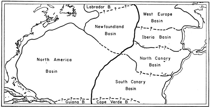
Figure 4.—Major basins of the North Atlantic, after Wüst (1940)
Heavy solid lines indicate boundary formed by axis of Mid-Atlantic Ridge. Light solid lines indicate boundary formed by shelf breaks and submarine ridges. Dashed lines indicate arbitrary boundaries.
The nomenclature of deep-sea topography has been considered by several committees during the past half century. The most recent recommendations published by Wiseman and Ovey (1953; 1955) are followed wherever applicable. The older systems of nomenclature, however, are not rigidly employed since we are dealing with textural provinces based on profiles obtained with continuously recording echo sounders rather than bathymetric provinces defined by closed isobaths.
UNITS OF DEPTH AND SLOPE
On the profiles and echograms the vertical scale is in units of echo-sounding time rather than in units of true depth. In other words, all depths are calculated under the assumption that the vertical sound velocity is 800 fathoms per second. Considering that the sound travels to the bottom and back, the calculation is based on 400 fathoms per second of lapsed time.
Since the average vertical velocity is, within the area covered, always slightly less than 800 fathoms per second, the true depth is always slightly greater than the "echo-time depth" as expressed in "nominal fathoms". Figure 5 shows the range of corrections which must be applied in various parts of the area. The spot depths indicated on the physiographic diagram are in units of true depth corrected according to Matthews' tables (1939) for regional variations in the average vertical sounding velocity.
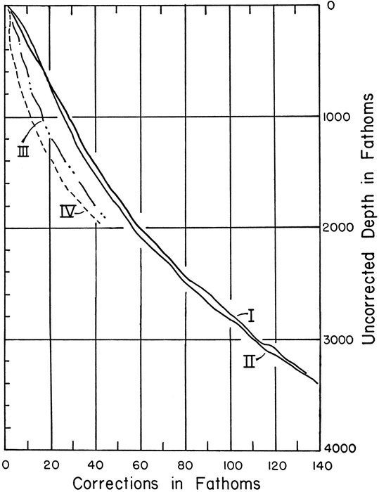
Figure 5.—Sound-velocity corrections for echo soundings
Add correction to uncorrected echo sounding to obtain true depth. Curves I and II are representative of North Atlantic 17°-50°N. exclusive of the Grand Banks region. Curves III and IV are representative of the deep-water areas near the Grand Banks. Curves are based on Matthews (1939) and are for use only where assumed sounding velocity is 800 fathoms/second. All soundings mentioned in the text are uncorrected for sound velocity.
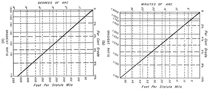
Figure 6.—Conversion diagram for degrees, per cent grade, feet per statute mile, and gradient
(a) Values of gradient from 1:10-1:1500; (b) Values of gradient from 1:100-1:5000
The inclination of the bottom is given as the tangent of the angle between the sloping plane and the horizontal expressed as a ratio of integers. These ratios are referred to as gradients. In Figure 6 slope values expressed in degrees, per cent grade, feet per statute mile, and gradient are compared. With a few exceptions all profiles are represented with a 40:1 vertical exaggeration. To facilitate judging the magnitude of slopes on these profiles, Figure 7 shows various gradient ratios at a 40:1 vertical exaggeration. Slope corrections have not been made to the soundings. Except in special cases such corrections would make insignificant changes in the 40:1 profile.
All distances are given in nautical or geographical miles (1 nautical mile = 6080 feet).

Figure 7.—Gradients from 1:5 to 1:8000 shown at a 40:1 vertical exaggeration
Most profiles reproduced in this paper are at 40:1 vertical exaggeration. This template is provided to aid the reader in judging slopes on these exaggerated profiles.
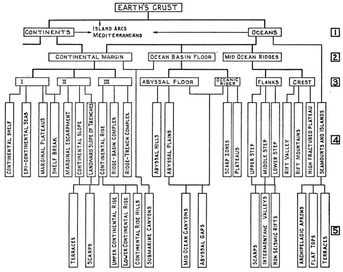
Figure 8.—Outline of submarine topography
Line 1, first-order features of the crust; line 2, major topographic features of the ocean; line 3, categories of provinces and super-provinces; line 4, provinces; line 5, sub-provinces and other important features.
CONTINENT AND OCEAN
The two first-order morphologic divisions of the earth's crust are continent and ocean. The oceans can be divided into a few major divisions which are in turn subdivided into categories of physiographic provinces and then into individual provinces. The area of the present study is composed of the three major divisions shown in Figure 9: continental margin, ocean-basin floor, and mid-oceanic ridge. The discussion and description of the physiographic provinces of the North Atlantic will follow the schematic outline shown in Figure 8.
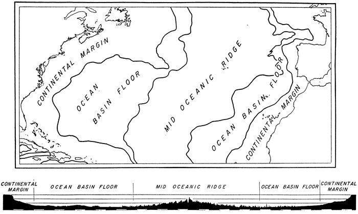
Figure 9.—Major morphologic divisions: North Atlantic Ocean
The profile is a representative profile from New England to the Sahara Coast.