Part 2 — MID-OCEANIC RIDGE
Reading edition
DEFINITION
The third basic subdivision of the oceanic depression is the Mid-Oceanic Ridge, a continuous median ridge which runs the length of the North Atlantic, South Atlantic, Indian and South Pacific oceans, for more than 40,000 miles (Heezen and Ewing, in press). In the center third of the physiographic diagram a short segment of this world-encircling ridge is represented.
MID-ATLANTIC RIDGE
One can find references to the Mid-Atlantic Ridge in the scientific literature dating back more than 80 years. Before the advent of the echo sounder the lateral limits of the Mid-Atlantic Ridge were very difficult to define, and even now widely different definitions are used. Murray (1912) mentioned that the ridge lay in depths less than 2000 fathoms but pointed out that locally on the ridge depths exceeded 2000 fathoms. The Meteor expedition charts and profiles generally imply by their labeling that the ridge is the area enclosed by the 4000-meter contour (2250 fathoms). Shepard (1948) states that its "average depth is about 1500 fathoms, but it rises about 1000 fathoms above deeper zones on either side."
Tolstoy and Ewing (1949) and Tolstoy (1951) in general limit the ridge to depths of less than 2500 fathoms, although in one part of the text Tolstoy and Ewing limit it to less than 2240 fathoms, and Tolstoy (1951) implies that the ridge extends to 2900 fathoms. In the present paper the Mid-Atlantic Ridge is considered as a morpho-tectonic unit defined in terms of morphology, and therefore its definition is not based on a closed isobath.
The Mid-Atlantic Ridge is that portion of the Mid-Oceanic Ridge system which lies within the limits of the Atlantic Ocean. It consists of a broad, fractured median arch or swell which occupies approximately the center third of the ocean. Its crest lies near the median line of the ocean, and its lateral boundaries are formed by scarps[2] which lie near the axes of maximum depth of the eastern and western basins. Adjacent to the Mid-Atlantic Ridge both to the east and to the west is the abyssal floor (usually abyssal hills) of the ocean-basin floor.
Exaggerated profiles are useful in bringing out the major morphological characteristics of deep-sea topography. For some purposes, however, it is desirable to study the topography in profiles with no vertical exaggeration. Two such profiles are shown in Figures 37-41. The position of the two profiles is indicated in Figure 36. A very good idea of the individual slopes can be gained from a study of these natural-scale profiles, but the province boundaries are very difficult to identify.
A typical cross profile at 40:1 exaggeration is shown in Figure 42, a typical oceanic cross section, in which each physiographic province of the Mid-Atlantic Ridge is labelled.
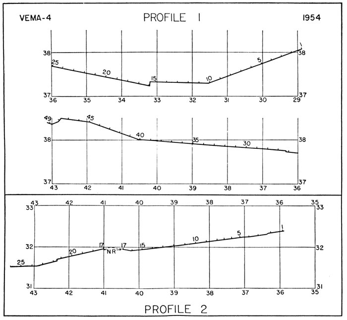
Figure 36.—Index to natural-scale Mid-Atlantic Ridge profiles reproduced in Figures 37-41
PROVINCES OF THE MID-ATLANTIC RIDGE
The Mid-Atlantic Ridge was subdivided by Tolstoy and Ewing (1949) and Tolstoy (1951) into (a) "the central backbone or main range which is shallower than 1600 fathoms," and (b) "the flanks" or "the terraced zone" "between the 1600- and 2500-fathom isobaths." In this paper we use a similar but somewhat differently defined system by dividing the provinces of the Mid-Atlantic Ridge into two categories: (1) the crest provinces, and (2) the flank provinces.
Crest provinces.—The provinces of the crest of the Mid-Atlantic Ridge consist of (1) the Rift Valley (or Valleys); (2) Rift Mountains; and (3) High Fractured Plateau (Fig. 43). The Azores Plateau, which forms part of the crest, presents additional problems and is discussed separately.
RIFT VALLEY: The most striking feature on an average profile across the Mid-Atlantic Ridge is a deep notch or cleft in the crest of the ridge. In a small percentage of the sounding profiles two or three such valleys are present, and on a few profiles no notable depressions are observed. On an average profile the floor of the valley lies at about 2000 fathoms, while the adjacent peaks average about 1000 fathoms below the sea surface. The width of the valley between the crests of the adjacent peaks ranges between 15 and 30 miles, and the depth of the valley floor beneath the highest adjacent peak ranges from 700 to 2100 fathoms. The width of the valley 500 fathoms above its floor ranges from 5 to 22 miles. The range in observed depths of the valley is 1150 to 2850 fathoms in the area of the physiographic diagram. The adjacent peaks range from 500 to 1300 fathoms within the same area (excluding the area near the Azores) (Fig. 47).
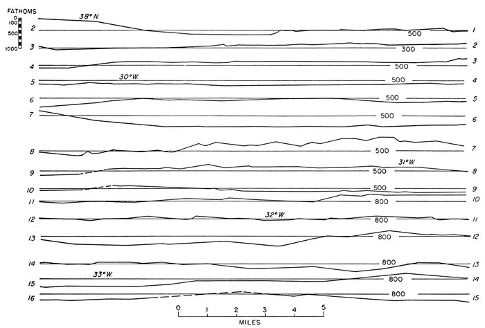
Figure 37.—Natural-scale Mid-Atlantic Ridge profile 1A
Slope corrections have been applied to profiles 1 and 2. The method is described by Elmendorf and Heezen (1957).
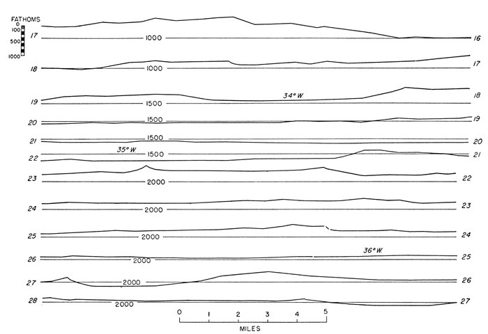
Figure 38.—Natural-scale Mid-Atlantic Ridge profile 1B
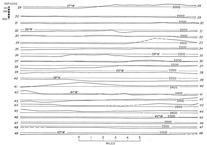
Figure 39.—Natural-scale Mid-Atlantic Ridge profile 1C
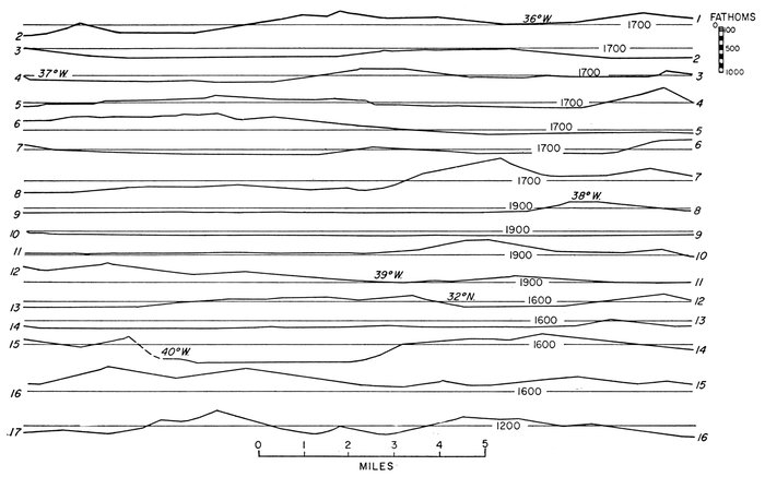
Figure 40.—Natural-scale Mid-Atlantic Ridge profile 2A
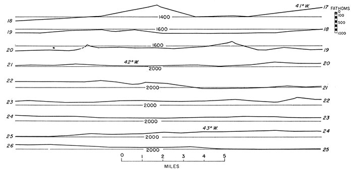
Figure 41.—Natural-scale Mid-Atlantic Ridge profile 2B
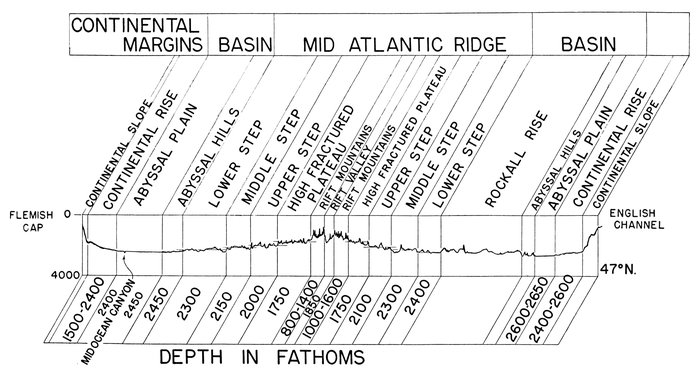
Figure 42.—Type profile, provinces of the Mid-Atlantic Ridge
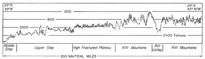
Figure 43.—Tracing of PDR record, Rift Valley, Rift Mountains, High Fractured Plateau, and Upper Step
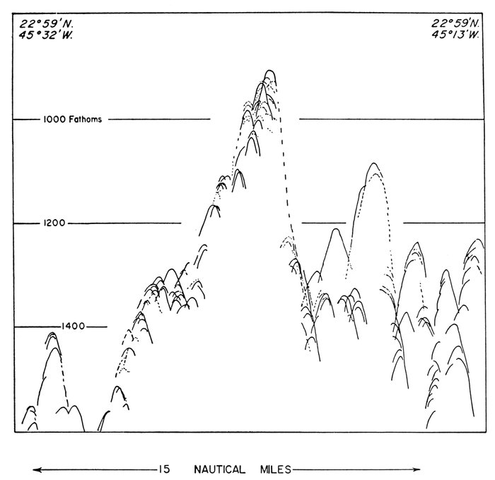
Figure 44.—Tracing of PDR record, Western Rift Mountains
Twenty-six crossings of the Rift Valley are shown in Figure 45. The profiles can be divided into three groups: (1) single well-developed rift valley; (2) several well-developed deep valleys; (3) no particularly deep central valley. Most of the profiles (20) fall into the first class; the second class is represented by 5, and only 1 falls in the third class.
The topography of the floor of the rift is rough. In no instance has a flat floor been observed. Where the valley is widest mountains a few hundred fathoms high protrude from its floor.
RIFT MOUNTAINS: The steep walls flanking the rift each form one side of a large rough-sided block. They might be considered as tilted blocks whose facing slopes form the Rift Valley. The back or outer slope of the Rift-Mountains Province is generally broken into mountains as much as 500 fathoms high and 10 miles wide (Fig. 44). The lateral limit of the Rift-Mountains Province is reached when the average slope of the sea floor flattens markedly. Because of the high local relief it is sometimes difficult to pick the boundary of the Rift Mountains, but in almost all recorded profiles the approximate position of the boundary is unmistakable.
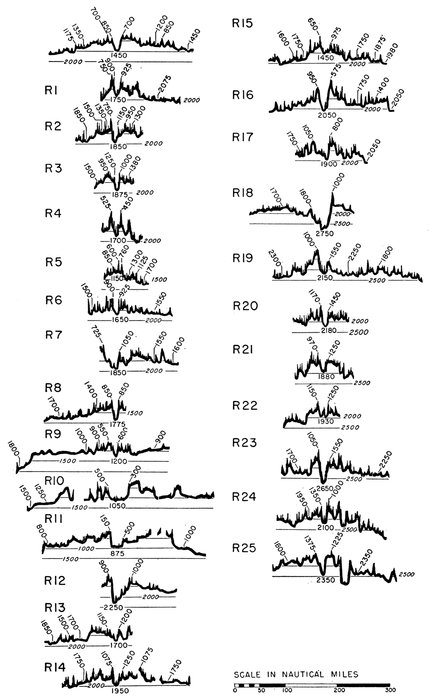
Figure 45.—Twenty-six rift valley profiles, Mid-Atlantic Ridge
Position of profiles shown on Plate 23
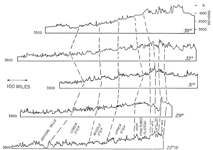
Figure 46.—Five representative profiles, crest and western flank of Mid-Atlantic Ridge
HIGH FRACTURED PLATEAU: The High Fractured Plateau is adjacent to the Rift Mountains on either side of the ridge (Fig. 42). The local relief is about 400 fathoms from peak to adjacent valley, and the distance from peak to peak ranges from 8 to 20 miles. In contrast to the adjacent flank provinces there are no filled intermontane valleys, and the valleys are deeper and narrower than in the adjacent Upper Step Province. Within the limits of the physiographic diagram, the average depth of the High Fractured Plateau ranges from 1500 to 1900 fathoms.
Flank provinces.—Between the outer margin of the High Fractured Plateau provinces and the level of the ocean-basin floor lies a succession of parallel provinces, known as the Upper Step, the Middle Step, and the Lower Step. The limits of these provinces are the least well defined of all the provinces described in this paper. The flanks of the ridge are characterized by rough topography (Pl. 18). Peaks of more than 200 fathoms high occur at a frequency of about 15 per 100 miles. Some of the valleys between peaks are smooth, particularly in the provinces south of the Azores Plateau. The flanks of the Mid-Atlantic Ridge are broken by scarps which seem to persist for relatively long distances parallel to the trend of the crest (Pl. 20). These scarps or scarp zones break the ridge into a succession of units here called steps (Fig. 46). An alternative solution also seriously considered by the writers is that the steps might more correctly be considered as a series of tilted blocks which could be referred to as ramps. The difference between the two solutions can be appreciated by inspecting Figures 42 and 46.
The writers must emphasize that the term "terraces" of Tolstoy is in no sense the same as the term "step" used in this paper. Tolstoy defined his terraces as "a succession of smooth shelves, each from 1 to 50 miles in width," which occupy a zone "200-300 miles" wide. Features fitting this definition are called "intermontane basins" in this paper, following a suggestion made by Heezen et al. (1951).
The location of smooth-floored intermontane basins is shown on Plate 20. They are found only in the area extending about 8° southwest of the Azores. Small arrows indicate the slope of the smooth floors. In general all the valleys slope away from the crest of the ridge. Steps, on the contrary, are a succession of average levels separated by scarps or scarp zones and in general are not smooth except that a few basins may be filled. However, this filling is limited to a small area south of the Azores.
The flanks are divided into three steps: upper, middle, and lower. The division of anything into three parts is suspicious, whether it be a geologic period or a physiographic region. Such divisions usually are later replaced as more information is obtained. This is probably true of the three steps. We are more confident of the significance of the boundaries shown on the province chart than of the uniqueness of the enclosed areas, because each boundary marks a major scarp or scarp zone. The steps are defined in part in any limited area on the basis of their mean depth. In general the Upper Step ranges from 1650 to 2300, the Middle Step from 2250 to 2500, and the Lower Step from 2350 to 2800 fathoms. Just as the maximum depth of the ridge and the axis of maximum depth of the basin vary with distance along the ridge (or with latitude), so the steps vary in depth and width (Fig. 47).
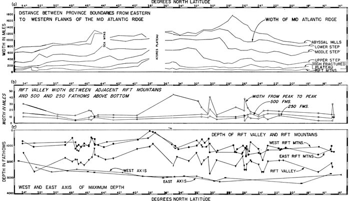
Figure 47.—Axial profile of the Mid-Atlantic Ridge
(a). Distance between province boundaries of the eastern and western flanks of the Mid-Atlantic Ridge measured along parallels of latitude.
(b). Width of the Rift Valley measured at 250 fathoms and at 500 fathoms above the valley bottom and between the highest peaks of the Eastern and the Western Rift Mountains. Width in miles measured at right angles to the trend of the ridge.
(c). The depth below sea level of the Rift Valley, the Rift Mountains and the western and eastern axes of maximum depth. The depths shown on this graph are in uncorrected echo-sounding fathoms.
Azores Plateau.—The Azores Plateau is an area of 52,000 square miles of sea floor, surrounding the Azores Islands, where the depth is less than 1000 fathoms. The Azores Islands are oriented south-southeast-north-northwest along a topographic trend which strikes off toward the Straits of Gibraltar. This topographic connection between the Azores Plateau and the southern Iberian Peninsula has been called the Azores-Gibraltar Ridge, which the present writers consider as a poorly developed mid-oceanic ridge of the same general class as the Mid-Atlantic Ridge. The Azores Plateau itself merges with the Rift Mountains of the Mid-Atlantic Ridge. The sea-floor topographic trends of the eastern part of the plateau are parallel to the known tectonic and volcanic trends of the Azores Islands (Agostinho, 1937). In the western part of the Azores Plateau trends are north-south parallel to the main trends of the Mid-Atlantic Ridge. Although both Wüst (1940a) and Tolstoy (1951) have published contour charts of the Azores Plateau, it remains largely a mystery whether the trends of the eastern Azores Plateau cross or join the axial trends of the Mid-Atlantic Ridge. The Azores Plateau or bulge is generally considered as a highly fractured tectonic uplift in which vulcanism has played a comparatively small part (Cloos, 1939).
Azores-Gibraltar Ridge.—An ill-defined irregular ridge runs from the eastern end of the Azores Plateau to the Straits of Gibraltar. Largely on the basis of its seismicity we infer that this ridge is structurally and topographically similar to the Mid-Atlantic Ridge. The few existing topographic profiles across this feature suggest that the earthquake belt is associated with a rift valley of the same general type as the central Rift Valley of the Mid-Atlantic Ridge. Depths in this rift appear to reach 2300-2800 fathoms, and the depth of the tops of the adjoining mountains range from 1600 to 2000 fathoms. The flank provinces are even less well developed.
Atlantis-Plato-Cruiser-Great Meteor Seamount Chain.—South of the Azores a chain of great seamounts branches off from the High Fractured Plateau and crosses the Upper and Middle steps in a nearly north-south direction. These seamounts—Atlantis, Plato, Cruiser, and Great Meteor—in general have broad, nearly flat summits at depths of 100-250 fathoms. The largest one, Great Meteor, was discovered by workers on the Meteor in 1937. This seamount, 60 miles across at its base, rises majestically more than 2600 fathoms above the floor of the ocean. Sands and calcareous rocks have been dredged from the summits, and Tertiary sediments have been obtained from the flanks of the seamounts. Photographs of the tops and of the flanks to a depth of 1600 fathoms show ripple marks. This group is described in a paper by Heezen, Ewing, Ericson, and Bentley (in press).
GEOLOGY AND GEOPHYSICS OF MID-ATLANTIC RIDGE PHYSIOGRAPHIC PROVINCES
Seismicity of the Mid-Atlantic Ridge.—The earthquake epicenters instrumentally determined for the North Atlantic up to 1956 are shown in Plate 29. Nearly all earthquakes fall in the crest zone. Considering that determination of shocks is accurate only to within -½° to 1° +, it is quite surprising that the plotted epicenters form such a narrow belt. Investigation of the problem of the physiographic province most seismically active reveals that many epicenters actually plot in the Rift Valley and that virtually all that do not are within about 1° of the Rift Valley. All seismic activity therefore is limited to the crest provinces, and probably virtually all the activity is concentrated within the Rift-Valley Province. A line of epicenters runs from the Rift Valley near Flores Island of the Azores toward the Straits of Gibraltar.
Sediments and physiographic provinces of the Mid-Atlantic Ridge.—The Mid-Atlantic Ridge is the major site of undisturbed pelagic sedimentation of the Atlantic because of its isolation from down-slope movements starting on the continental margin. However, turbidity currents must form near the shores of oceanic islands and the edges of shallow banks and probably contribute sediments to the intermontane valleys. Photographs taken on the Rift Mountains and on the sides of major seamounts show scour marks and ripple marks, indicating considerable winnowing and scour by deep-ocean currents (Pl. 19). This sediment carried from the tops of peaks and deposited on the steep mountain sides probably slumps occasionally and forms turbidity currents which flow to the adjacent valley floors (Pl. 28). For this reason cores taken in intermontane valleys and near the higher peaks will have considerable interlayering of turbidity-current deposits, and much of the sides and crests of individual high mountains is bare rock. In the Rift Mountains true pelagic sediments are only occasionally found. It is striking to note that in coring and bottom photography bare-rock slopes are found most commonly in the Rift Mountains and High Fractured Plateau, but flat-floored intermontane basins are absent in these provinces. This must indicate either that the topography of the Rift Mountains is very new or that the sediment eroded from the crest provinces is carried all the way to the Upper Step Province where it is deposited in the intermontane basins.
Rocks of the Mid-Atlantic Ridge.—Our knowledge of the lithology of the Mid-Atlantic Ridge comes from three sources: (1) rocks dredged from the sea floor, (2) detrital rock fragments found in sediment cores, and (3) rocks exposed on the islands of the Ridge.
Some of the earliest rock dredging on the Mid-Atlantic Ridge was done in 1885 by the Talisman expedition. In 1949 Furon (1949) reported the occurrence of fossil trilobites in dredge samples which had been stored for more than half a century in a French Museum. One dredging was made in the High Fractured Plateau of the eastern Atlantic at 42° 21´N., 17° 12´W., in 4255 meters depth (2330 fathoms). Furon believes that the material was in situ and therefore proof of early Paleozoic outcrops on the Mid-Atlantic Ridge. The abundant evidence of glacially rafted rocks even as far south as 30° N. casts serious doubt on this conclusion, but nevertheless the possibility that the material might have been in situ must be considered.
The Mid-Atlantic Ridge Expedition of 1947 led by Ewing made a number of successful rock-dredge hauls on the Mid-Atlantic Ridge. The most successful hauls were made in the Rift Valley and on the adjacent Rift Mountains at about 30° N. Lat. The specimens have been described by Shand (1949), who reported olivine gabbro, serpentine, basalt, and diabase. One limestone of probably Tertiary age was collected the same year but has not been described. The suite of crystalline rocks obtained is similar to those found on oceanic islands elsewhere on the Mid-Oceanic Ridge.
Crustal structure and the Mid-Atlantic Ridge provinces.—The crustal structure of the Mid-Atlantic Ridge provinces has been determined at about 20 places by the seismic-refraction technique (Fig. 35f). These studies, conducted by John I. Ewing and W. M. Ewing (in press), have shown that the average crustal structure of the crest provinces and Upper Step consists of 0.4 km of low-velocity sediment and 2.8 km of rock with a velocity of 5.1 km/sec overlying a substratum in which the velocity is 7.3 km/sec. The thickness of the layer of low-velocity sediment varies considerably from place to place. In the crest provinces the 5.1 km/sec layer is commonly exposed. In the flank provinces appreciable thicknesses (to 1 km) of sediment have been measured. The sediment seems to thicken between major scarp zones and ridges as if the sediment were collecting in longitudinal basins parallel to the axis of the ridge. An insufficient number of measurements have been made to determine whether these accumulations correlate with the boundaries of individual intermontane basins or with the limits of individual step provinces.
The structure of the abyssal floor, crest provinces, and flank provinces is compared in Figure 35. The two higher-velocity layers shown in the abyssal-floor sections (Nares and Sohm Abyssal Plain, Fig. 35), have been observed in all measurements made in these provinces. The 6.7 km/sec layer is generally considered to be gabbroic, and the 8.1 km/sec layer is by definition the earth's mantle. In the Mid-Atlantic Ridge section the upper high-velocity material has an average velocity of 5.1 km/sec and is generally identified as basaltic rock. The velocity of the underlying material (7.3 km/sec) is intermediate between the velocity of oceanic crustal rocks (6.7 km/sec) and that of mantle rocks (8.1 km/sec), as observed both beneath the continents and beneath the abyssal floor.
Ewing and Ewing (in press) suggest that this intermediate velocity is the result of a physical mixture of oceanic crustal rocks and mantle rocks. To explain such large-scale mixing they propose that extensive vulcanism and intrusion along the Mid-Atlantic Ridge have produced an intermingling of the crustal and mantle rocks, and that this was associated with convection cells in the deep mantle which supply large quantities of basaltic magma and produce extensional forces on the crust and upper mantle.
Nearly 20 crossings of the crest of the ridge have been made with the total-intensity magnetometer towed behind research vessels employing continuously recording echo sounders. A characteristic anomaly pattern has been noted by Ewing, Heezen, and Hirshman (1957). The Rift Valley is characterized by a large positive anomaly, while the adjoining Rift Mountains show negative anomalies of 300 to 500 gammas (Fig. 48).
Free-air gravity anomalies over the crest provinces and Upper Step are usually 30-50 mg positive, while the Rift Valley as measured in two places gave free-air anomalies of -3 and -20 mg.
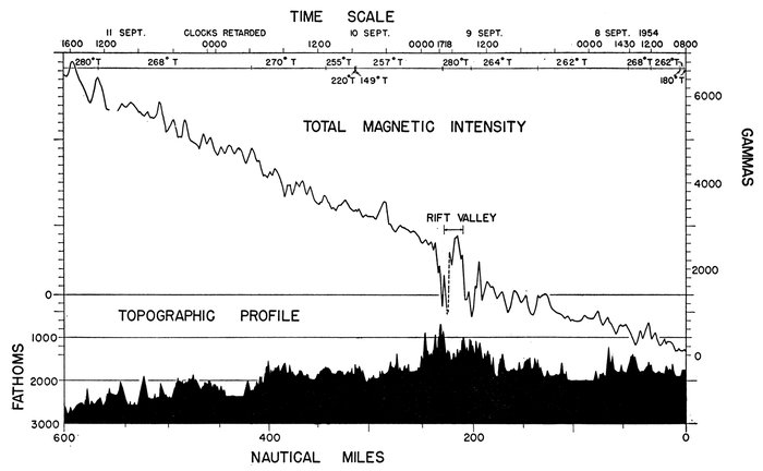
Figure 48.—Profile of total magnetic intensity and topography, Mid-Atlantic Ridge
Soundings made with PDR. Magnetic measurements made with fluxgate total-intensity magnetometer. Magnetic values in gammas relative to an arbitrary zero.
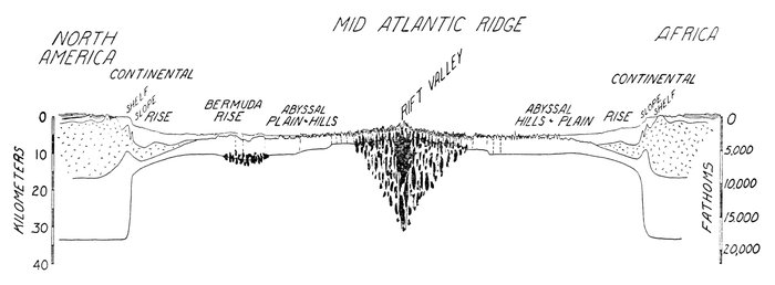
Figure 49.—Physiographic provinces and trans-Atlantic structure
Based on scattered seismic-refraction measurements in the North Atlantic which have been projected along province boundaries. The topographic profile was pieced together from continuously recorded echo-sounding profiles from New York to Spanish Sahara.
In the continental margin the upper layer represents the sedimentary rock. The dashed symbol indicates the continental crustal rocks. The lower layer represents oceanic crustal rocks. The mantle lies below the lowest layer.
A heat-flow measurement by E. C. Bullard in the Rift Valley province in the North Atlantic indicated a value of about 7 × 10⁻⁶ cal./cm2/sec. which is about 6 times the average value of 1.2 × 10⁻⁶ cal./cm2/sec observed in the Lower Step and abyssal floor of the eastern Atlantic (Bullard, 1954; Bullard et al., 1956).
High heat-flow values have also been observed on the Easter Island Ridge of the Southeast Pacific, suggesting that the entire Mid-Oceanic Ridge rift system may be so characterized.
An adequate synthesis and explanation of all these converging lines of evidence has not yet been formulated. However, the correlation of so many types of geophysical and geological data speaks favorably for the validity and tectonic significance of the physiographic provinces described here.
On the basis of the observed correspondence of crustal structure and physiographic provinces a hypothetical trans-Atlantic structure section was prepared (Fig. 49). Seismic-refraction measurements were projected along province boundaries and plotted beneath an echo-sounding profile from New York to Spanish Sahara. The black splotched areas represent the 7.3 km/sec layer. This velocity intermediate between 8.1 km/sec of normal mantle and 6.7 km/sec of normal oceanic crust is considered (1) a mixture of the two normal layers; (2) a low-velocity part of the mantle, or (3) a distinct crustal layer characteristic of mid-oceanic ridges. The structure shown for the continental margin of Africa is based on analogy with the structure of the continental margin of northeastern United States. This procedure seems justified by the close similarity of the continental-margin physiographic provinces of the two areas.
Origin of the Mid-Atlantic Ridge.—Of the many theories which have been proposed for the origin of the Mid-Atlantic Ridge almost all have been extremely speculative, and none has been based on any very detailed knowledge of the feature. We are still a long way from having a comprehensive knowledge of the Ridge. The various theories of origin and their factual basis have been briefly reviewed by Tolstoy and Ewing, who conclude that it is impossible to say if the feature is primarily of folded or faulted origin. In a paper in press Heezen and Ewing compare in detail the topography and seismicity of the African rift valleys and the Rift Valley of the Mid-Atlantic Ridge. Their conclusion is that the two areas are of basically the same structure, and in fact both form parts of the same continuous structural feature. Since the African rift valleys seem clearly to be the result of normal faulting resulting from extension of the crust, Heezen and Ewing conclude that the topography of the Mid-Atlantic Ridge is largely the result of normal faulting. Whether the forces are the result of horizontal extension or vertical uplift remains the most important unsolved problem in connection with the origin of the continental as well as the suboceanic rift-valley systems. Hess (1954) has proposed a mechanism relating suboceanic uplift to expansion due to serpentization of the upper mantle.
SUB-BOTTOM REFLECTIONS RECORDED ON PRECISION DEPTH RECORDER RECORDS AND PHYSIOGRAPHIC PROVINCES
In some areas of the ocean PDR records show a reflecting surface a few fathoms below the bottom. Such horizons are observed only when the sounder is operated with a short (5-millisecond) ping length (in echo sounding the transmitted sound is called the ping, and its duration is called the ping length). When a long ping is used the first returning echo masks any subsequent echoes occurring less than about 10 fathoms after the first echo. To establish continuity of the lower horizon it is necessary to run the recorder without interruption, sending pings once a second. Since a faulty pinging circuit or some accident of geometry could conceivably send out two closely spaced pings, the supposed sub-bottom echoes must be carefully checked to make sure that they are not both bottom echoes from two closely spaced pings. If two pings were being sent out the second echo would always symmetrically underlie the bottom surface. If, however, the two surfaces show local variations, it can be safely concluded that the deeper one is a true sub-bottom echo. In order to observe sub-bottom echoes the sea floor should be reasonably smooth since in rugged relief side echoes and crossing "highlight" hyperbolas obscure any sub-bottom echoes which might occur. Sub-bottom echoes in the Gulf of Maine have been well described by Murray (1947). In local inshore areas prominent sub-bottom echoes recorded by unmodified or slightly modified standard echo sounders have been used to map basement rocks (Smith et al., 1952).
In the deep sea, sub-bottom echoes or "penetration" are observed most frequently in the continental rise, oceanic rises, and the far edges of the abyssal plains. Penetration is rare on the open continental shelf and on the continental slope. As the depth increases, echoes are more difficult to obtain, so that records from different depths cannot be directly compared in reference to ease of penetration. It nevertheless seems to be true that sub-bottom echoes are rare or absent on PDR records from the parts of the abyssal plains closest to the continental margin. Penetration in the continental rise is common but frequently irregular and intermittent. One of the most persistent and uniform sub-bottom reflecting horizons observed occurs on the outer ridge east of the Bahamas (south of 30° N.) (Pl. 6).
Records from the abyssal plain immediately adjacent to the abyssal hills (Pl. 13 Fig. 4) and from the flat-floored tongues in the abyssal hills (Pl. 10) reveal some of the deepest and strongest sub-bottom echoes. Good sub-bottom echoes are common in the Bermuda Plateau.
The sub-bottom reflecting layers frequently crop out, and the overlying sediments thicken and thin, revealing apparently noticeable variations in the rate of accumulation of sediments. Outcropping of sub-bottom layers on the steeper slopes indicate slumping, while the deepening of the sub-bottom reflecting horizon in valleys indicates a greater rate of deposition. High-frequency sound is normally strongly attenuated by transmission through sediments. The observation of sub-bottom reflections with high-frequency sound pulses (12 kc) indicates (1) that the surface sediment is uniform and is of low density, and (2) that a fairly sharp density change occurs beneath this surface layer of low-density material. In areas such as the outer ridge from 22° to 29° N. Lat. and the southern Bermuda Rise, it can be safely assumed that the upper layer consists of deep-sea red clay. Density measurements on red clay have indicated values of 1.25 to 1.45. The lack of sub-bottom reflections over the parts of the abyssal plains close to the continents is attributed to the numerous sand and silt layers found in the cores which reflect most of the sound. The occurrence of good reflections beneath the outer edges of the abyssal plains could be explained by either assuming that for a long geologic time no sand-or silt-carrying turbidity current has reached this area, or that red clay is deposited here much faster than elsewhere.
An extremely prominent sub-bottom reflector observed over a vast area of the east tropical Pacific has been identified by coring with a 10-cm thick bed of white, vitreous ash. This suggests that sub-bottom reflections found elsewhere may, in general, represent ash horizons. This, of course, would presuppose ash falls so vast that some record should have been preserved on land. There is no reason to assume that there is but a single cause of deep-sea sub-bottom echoes.
The widespread occurrence of the sub-bottom interface on the deeper isolated rises may be of great importance if it be interpreted as evidence of a sudden change in sedimentation resulting in a change from higher- to lower-density sediment. It is just conceivable, however, that some unstable diagenetic process may cause a sudden increase in compaction at a depth corresponding to the sub-bottom reflection.
The sub-bottom reflections in depths of 2600 fathoms on the southern Bermuda Rise and the outer ridge is about .02 second after the bottom echo, and this indicates a layer about 10 fathoms thick. At a rate of deposition of 1 cm/1000 years this change in sediment type would have occurred 20 million years ago.
In a remotely situated oceanic area the factors controlling whether red clay or Globigerina ooze is laid down are largely related to depth and temperature of the bottom water. These two factors are related to those which control the solubility of the carbonate and thus the type of bottom deposit. Emiliani and Edwards (1953), from a study of oxygen isotopes in benthic Foraminifera in Tertiary deep-sea sediments from the eastern Pacific, concluded that the temperature of Pacific bottom water decreased 8° C. from the Eocene to the present. This should have caused a great increase in the solution of carbonate assuming other factors unchanged. Sub-bottom reflections then may also be interpreted as the result of a change in the temperature or the circulation of bottom water in the deep basin. Extensive, basin-wide sub-bottom reflectors, whether the result of vast beds of ash or widespread changes in pelagic sedimentation, imply events of global importance. The further investigation and identification of these reflectors should produce data of far-reaching application in geology, climatology, and paleo-oceanography.
SUMMARY OF PROVINCE CHARACTERISTICS
The Atlantic Ocean floor consists of three major morphological divisions: (1) continental margin, (2) ocean-basin floor, and (3) Mid-Oceanic Ridge. The continental margin is formed by three categories of provinces which represent (1) the submerged continental platform, (2) the steep edge of the continental block, and (3) the raised or depressed edge of the ocean floor. The topographic detail of the continental margin is predominantly smooth except for the submarine canyons and minor irregularities of the upper continental rise. A close correspondence of topography and distribution of recent sediments is apparent. For example, deep-sea sands are found in the submarine canyons and on the canyon deltas of the lower continental rise. The continental slope appears to be a thinly veneered or bare outcrop of Tertiary and Mesozoic sediments. Individual topographic benches can be traced for many miles along the strike. On the basis of published descriptions and dating of dredged rock, certain prominent benches are identified as the outcrop pattern of various Cretaceous and Tertiary formations. The lower continental rise can be directly traced into the outer ridge at Cape Hatteras. The upper continental-rise and the marginal-trench provinces lie between the abrupt continental slope and the outer ridge. Seismic-refraction measurements in the continental margin indicate the greatest thickness of sedimentary rocks under the upper continental rise. Thus if we consider the initial form as an unfilled depression it would have been remarkably similar to the form of the present marginal trenches.
The ocean-basin floor lies between the continental margin and the Mid-Oceanic Ridge and consists of the deeper abyssal floor and the elevated oceanic rises. On the abyssal floor adjacent to the continental margins are found the flattest surfaces of the earth. These abyssal plains apparently were built by turbidity-current deposits. The unburied abyssal floor is represented by the abyssal hills. The oceanic rises are broad uplifts which rise from the abyssal floor through a series of scarps. Oceanic rises are covered with pelagic sediments except locally near islands and seamounts. The crustal structure of oceanic rises differs significantly from the typical abyssal floor in having lower velocities and generally thicker crustal layers.
The Mid-Oceanic Ridge is a broad fractured arch whose axis follows the median line of the ocean. It generally covers the center third of the ocean. The ridge provinces are divided into crest provinces and flank provinces. The crest provinces include (1) the Rift Valley, a long axial cleft 15-30 miles wide and 500-1500 fathoms deep; (2) the Rift Mountains which form the sides of the Rift Valley; and (3) the High Fractured Plateau, a rugged plateau which borders the Rift Mountains. The flank provinces consist, on each side, of roughly three steps separated by large scarps. A seismic belt accurately follows the Rift Valley. The topography of the Mid-Oceanic Ridge seems best explained by extensive normal faulting. The mid-oceanic Rift Valley connects with and is probably of the same origin as the African rift valleys.