Part 2 — OCEAN-BASIN FLOOR
Reading edition
GENERAL DESCRIPTION
The second of the three basic topographic divisions of the oceanic depression is the ocean-basin floor. Included in this division are those provinces of the oceanic depression that are not included in the continental margin or the mid-oceanic ridge.
The ocean-basin floor is divided into three categories: (1) abyssal floor, (2) oceanic rises, and (3) seamounts and seamount groups. The first category includes two types of provinces, abyssal plains and abyssal hills, which occupy the deepest portion of the ocean-basin floor. Included in these provinces are such features as abyssal gaps and mid-ocean canyons. The second category includes the larger positive features of the ocean-basin floor, and the large seamounts and seamount groups fall in the third category. The landward limit of the ocean-basin floor is the 1:1000 gradient isopleth along the continental margin. Along the mid-oceanic ridge the boundary is taken as that scarp or scarp zone where the average level rises appreciably above the axis of maximum depth of the basin floor. Broad elevations which rise above the basin floor as isolated rises are termed oceanic rises and are included in this discussion even though they may be structurally more closely related to the mid-oceanic ridge or the continental margin.
ABYSSAL PLAINS
General discussion.—An abyssal plain has been defined (Heezen, Ewing, and Ericson, 1954) as "an area of the deep-ocean floor in which the ocean bottom is flat and the slope of the bottom is less than 1:1000".
Abyssal plains have been found in all oceans, characteristically at the foot of the continental rise. Koczy (1954; 1956) and Gaskell and Ashton (1954) have described the abyssal plain south of the Bay of Bengal. Koczy (1956) has described plains in the equatorial Atlantic on either side of the Mid-Atlantic Ridge. On Expedition Deep Freeze workers on the USS Glacier, using a PDR, discovered an abyssal plain in the Weddell Sea. Workers on the R. V. Vema in 1957 confirmed the existence of abyssal plains in the Argentine and in the Cape and Angola basins of the South Atlantic. Menard (1955) has described abyssal plains off the California and Alaska coasts. Abyssal plains are really important and are present off all coasts except those having a long, continuous, unfilled marginal trench.
The abyssal plains shown on the physiographic diagram have been named in order to facilitate referencing. The abyssal plains of the western Atlantic between Newfoundland and the West Indies are best known. The "abyssal plain south of Newfoundland" (Heezen et al., 1954) has been named the Sohm Abyssal Plain following the usage of Murray (1912) who referred to this area as "Sohm Deep" in several publications. The abyssal plain south of the Bermuda Rise referred to as the "abyssal plain in the Nares Basin" (Heezen, Ewing, and Menzies, 1955; Luskin et al., 1954) is named on the province chart (Pl. 20) the Nares Abyssal Plain, also following the usage of Murray (1912), who named this area the Nares Deep. The abyssal plain southwest of the Bermuda Rise was included in the Nares Abyssal Plain until the discovery in 1955 that the two parts were separated by a steep abyssal gap at 24° N. 68° W. necessitated the splitting off of this plain from the Nares Abyssal Plain. The name Hatteras Abyssal Plain used on the map was suggested by the close proximity of the very prominent Cape Hatteras.
An abyssal plain is probably present in the Newfoundland basin, but no PDR soundings have been obtained in that area. The name Newfoundland Abyssal Plain is suggested subject to confirmation by a precision survey.
The outer ridge which runs south from Cape Hatteras paralleling the coast lines of the Bahamas encloses the Blake-Bahama Basin (Ericson, Ewing, and Heezen, 1952); a narrow abyssal plain is found along its western margin. This plain is named the Blake-Bahama Abyssal Plain.
Between the Greater Antilles and the Bahama Banks is a depression called the Old Bahama Channel in the north; farther south it is known as the Hispaniola-Caicos Channel. The Hispaniola-Caicos Channel in particular contains an abyssal plain which, although much smaller than the large, deep-sea abyssal plains, has all the characteristics of slope flatness and sediment composition. This is called the Hispaniola-Caicos Abyssal Plain.
The smallest, yet perhaps the most striking, Atlantic abyssal plains are those at the bottom of the Puerto Rico Trench at depths of about 4358 fathoms (4585 corrected). They exhibit the proper degree of flatness, low gradient (Ewing and Heezen, 1955), and the shallow-water clastic sediments typical of abyssal plains.
South of Cuba in the southwest corner of the diagram lies a major deep-sea trench. Only the eastern end of this Cayman Trench is shown in the diagram. On the floor of this steep-walled trench lies a narrow trench plain or system of semi-connected trench plains which lie at depths of about 3000 fathoms south of Guantanamo, Cuba, but deepen to 3692 fathoms south of the Cayman Islands. These are known as the Cayman Trench Plains. This area will be described in more detail in a later publication devoted to the topography of the Caribbean.
In the eastern Atlantic each abyssal plain has been crossed at least three times by ships employing a PDR, a coverage which, although sufficient to establish their existence, is vastly inferior to the coverage of the western Atlantic abyssal plains. The Biscay Abyssal Plain occupies a large portion of the Bay of Biscay. It is connected by an abyssal gap at 43° 30´N., 12° 00´W., to the Iberia Abyssal Plain which lies west of the northern two-thirds of the Iberian Peninsula. A small abyssal plain west of the Tagus River takes its name from this river. The great abyssal plain which skirts Madeira on the east and south and extends over a vast area to the west is referred to as the Madeira Abyssal Plain. The Canary Islands and associated banks form the boundaries of a small oval depression known as the Canary Abyssal Plain. The vast abyssal plain which skirts the African continent west of Cape Verde is named the Cape Verde Abyssal Plain.
The eastern margin of the map just reaches the abyssal plain in the western Mediterranean which Heezen and Ewing (1955) have named the Balearic Abyssal Plain.
Abyssal plains were not discovered until the use of continuously recording echo sounders was extended to abyssal depths following World War II (Tolstoy and Ewing, 1949). While the early nonprecision echo sounders were sometimes adequate to distinguish the limits of particular plains, real advances in their study required the development of precision sounders and the extensive use thereof (Heezen, Ewing, and Ericson, 1954). Since the very existence of abyssal plains has been known for less than 10 years and only recently have any of them been adequately delineated, the problem of their nomenclature has never before arisen.
In the cases of the Nares and Sohm abyssal plains we have taken the name Murray has given to the "deeps" in which the plains occur. For Cape Verde, Iberia, and Newfoundland abyssal plains we have followed the name Wüst (1940b) proposed for the basin within which the plains lie. The Biscay, Tagus, Hatteras, Blake-Bahama, Hispaniola-Caicos, and Balearic have been given the name of a prominent near-by land area, in accordance with recognized practice. The Horseshoe Abyssal Plain takes its name from the horseshoe-shaped line of seamounts which surrounds it except on the eastern side.
Regional description.—The relief of the abyssal plains is so low that ordinary small-scale exaggerated profiles (Pls. 22, 27) reveal nothing of its detailed character. In a few areas exceptionally good PDR records have been obtained which show relief of a few feet (Pl. 12).
SOHM ABYSSAL PLAIN: The best-studied abyssal plain is the Sohm Abyssal Plain south of Newfoundland. In addition to the 1953 Vema PDR survey (Heezen et al., 1954) the area was studied extensively in 1955 and crossed by the trans-Atlantic cruises of 1954 and 1956. The plain is T-shaped and generally about 200 miles wide; depths range from 2700 to 3000 fathoms (uncorrected). The depth increases in each arm of the T toward the stem where the slope changes to south. The greatest depth is found at the south boundary of the plain near 29° N. In the northern part of the plain small topographic irregularities are unknown, but toward the south peaks 50 to 500 fathoms high increase in number until they finally replace the plain. North of the Bermuda Rise the plain surrounds a line of huge seamounts. However, even here no small hills are found. In the strip extending between 30° and 37° N., the east and west boundaries of the plain are formed by scarps 200 to 800 fathoms high. The boundary on the north side of the Bermuda Rise is formed by a distinct shallowing, but no scarp is seen.
There is some justification for separating the northwest arm of the Sohm Abyssal Plain north of the Bermuda Rise from the rest of the Sohm Abyssal Plain since a mid-ocean canyon runs from the northwest to the central sections of the plain. A sill might lie northeast of the northeast tip of the Bermuda Rise. Here the bottom gradient changes slightly, and an extremely large magnetic anomaly is associated with the region. However, the plain narrows only slightly at this point, and, since we cannot tell how many individual basins were filled to form an abyssal plain, we will consider that the Sohm Plain now includes the whole area, keeping in mind that the northwest arm may have only recently merged with the rest.
South of Newfoundland the continental rise merges with the abyssal plain with no scarp or line of hills. Here the boundary is taken at the point where the gradient is gentler than 1:1000. This is not an entirely arbitrary definition since an appreciable change in gradient generally occurs near this point. South of the boundary the gradient gradually decreases to 1:3000 at 37° N., beyond which it decreases even more gradually and reaches 1:5000 at the southern edge of the plain.
HATTERAS ABYSSAL PLAIN: Northeast of the Bermuda Rise on a line between Long Island (N. Y.) and Bermuda a small area of abyssal hills lies between the continental rise on the northwest, the Bermuda Rise on the southeast, the Sohm Abyssal Plain on the northeast, and the Hatteras Abyssal Plain on the southwest. Although this area has been traversed by more tracks than any area of similar size in the Atlantic, the relationships here are still somewhat obscure. This area of some 6000 square miles is one of irregular relief, but it is not known if it is of the character of an irregular sill or a complex abyssal gap, although the latter seems more probable. The northwest margin of the Hatteras Abyssal Plain is abruptly formed by the lower continental rise hills. The eastern boundary is generally distinct and in places is formed by a 50- or 100-fathom scarp, but generally it is not so impressive as the east and west boundaries of the Sohm Abyssal Plain. South of about 34° N., the western boundary of the Hatteras Abyssal Plain is formed by the outer ridge. In some sectors the eastern flank of the outer ridge is rather gentle, and the abyssal plain gently laps the ridge without a sharp break. This boundary is generally sharp north of 27° N. but to the south is less definite. The Hatteras Plain slopes southeast to about 31° N. where the direction of slope changes to south. A gradient of about 1:3000 and depths of about 2900 fathoms are reached at 25° N. Within about 60 miles of Vema Gap the plain is broken by numerous mid-ocean canyons which converge on the gap (Pl. 14, fig. 3). The Hatteras Abyssal Plain has no known seamounts or sea knolls, in contrast to the Sohm Abyssal Plain and Nares Abyssal Plain.
The sediments of the Hatteras Abyssal Plain resemble the northern abyssal plains in having many beds of quartz silts (Pl. 28) and contrast sharply with the Blake-Bahama Abyssal Plain where calcareous sands are abundant. On the west the outer ridge forms a continuous barrier to turbidity-current sediments coming from the near-by Bahamas so that the only source of turbidity-current sediments is from the Cape Hatteras region to the north or possibly from the Hudson Canyon via the suspected abyssal gap mentioned above. The type of sediment is entirely consistent with the gradient of the plain which slopes southward from the Hatteras region.
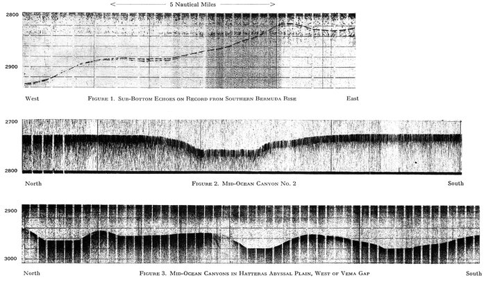
Figure 1. Sub-Bottom Echoes on Record from Southern Bermuda Rise
Figure 2. Mid-Ocean Canyon No. 2
Figure 3. Mid-Ocean Canyon in Hatteras Abyssal Plain, West of Vema Gap
PDR RECORDS OF MID-OCEAN CANYON NO. 2 AND CANYONS AT VEMA GAP
Depth in fathoms.
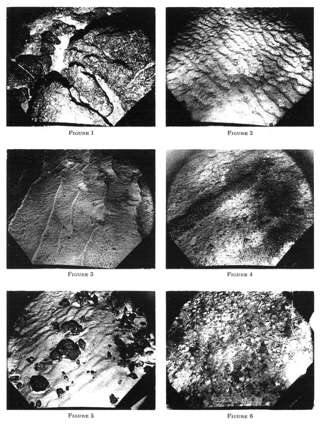
Area of each photograph is about 6 by 8 feet.
Plate 15.—OCEAN-BOTTOM PHOTOGRAPHS OF SEAMOUNTS
Figure 1. (Station V4-12, photo 16) Depth 700 fathoms, location 35° 12´N., 15° 18´W., on seamount of the Horseshoe Group. Note bioclastic debris lodged in depressions on the rocky bottom. Photographs shown in Figures 1, 2, and 3 are no more than a few hundred feet apart.
Figure 2. (Station V4-12, photo 10) Depth 700 fathoms, location 35° 12´N., 15° 18´W. Rippled sandy bottom.
Figure 3. (Station V4-12, photo 7) Depth 710 fathoms, location same as Figures 1 and 2. Note current ripple marks. The photograph indicates an appreciable current from left to right.
Figure 4. (Station V4-16, photo 19) Depth 1100 fathoms, location 35° 07´N., 13° 04´W., on the side of Ampere Seamount. Note winnow row of dark and light gravel-sized detritus which resembles similar material on the Rift Mountains shown in Figure 1 of Plate 19.
Figure 5. (Station V4-18, photo 26) Depth 75 fathoms, location 35° 10´N., 12° 55´W., near the top of Ampere Seamount.
Figure 6. (Station V4-14, photo 47) Depth 1100 fathoms, location 35° 12´N., 15° 22´W. on same seamount as Figures 1-3. Bottom appears to consist of light-colored sediment thinly veiled by dark coarser sediment. The white polka dots appear to represent piles of the underlying light sediment brought to the surface by burrowers.
Positions of stations shown on Plate 30
BLAKE-BAHAMA ABYSSAL PLAIN: The Blake-Bahama Basin is a long narrow basin between the great Blake Escarpment and calcareous Bahama Island banks on the west and the outer ridge on the east. A narrow abyssal plain 20 to 70 miles wide spreads out from the base of the escarpment (Pl. 5, fig. 3). The plain is shallowest and widest just east of the Northeast Providence Channel and deepens and narrows toward its northern and southern ends. Sediment cores taken 60 miles off the mouth of Northeast Providence Channel contained graded beds of calcareous sand a few meters thick (Ericson et al., 1952). The material was obviously derived from the Bahamas, presumably through the action of turbidity currents running out through the Providence Channels, the southern entrance of Exuma Sound, and the numerous submarine canyons which dissect the slopes off the islands. The depth of the plain ranges from 2600 to 2750 fathoms, and its area is about 7000 square miles.
NARES ABYSSAL PLAIN: South and southeast of the Bermuda Rise lies the Nares Plain, a 37,000-square-mile abyssal plain that slopes eastward from Vema Gap toward the Mid-Atlantic Ridge. From 62° to 64° W. its northern and southern boundaries are abrupt, and only three or four small abyssal hills have been observed in the plain. East of 64° W. the gradient of the plain exceeds 1:2500, and the frequency of hills increases until at 61° W. the plain consists of a series of fingers which extend into the abyssal hills. The sediment cores obtained in the Nares Abyssal Plain consist of alternating red clays and quartz silts (Ericson et al., 1952; in press). The Nares Abyssal Plain is the deepest of the broad abyssal plains of the ocean-basin floor. It is also the farthest from the land. If the turbidity currents smoothed the Nares Plain they would all have had to flow through Vema Gap since the outer ridge-trench complex to the south prevents currents from this area from reaching the Nares Abyssal Plain. The idea of a route through Vema Gap is supported by the fact that the plain slopes eastward from the gap.
HISPANIOLA-CAICOS ABYSSAL PLAIN: The depression between the Bahamas and the coasts of Cuba and Hispaniola deepens east of Cay Lobos and reaches its maximum depth of 2220 fathoms northwest of Cape Francis Viejo of Hispaniola. At Cay Lobos the channel is a steep V-shaped depression with a maximum depth of 400 fathoms, but to the east this V-shaped channel opens out to an abyssal plain about 1500 fathoms deep. Between this point and Great Inagua Island the flat floor slopes east reaching a depth of 1575 fathoms just southwest of Inagua. This portion is called the Old Bahama Abyssal Plain. South of Great Inagua is another V-shaped channel in which the depth drops from 1700 fathoms on the west to 2200 fathoms on the east. From this point to Cape Francis Viejo the Hispaniola-Caicos Abyssal Plain is nearly flat. Sediments collected from this plain confirmed the turbidity-current origin of the smooth topography. The cores contained plant debris, shallow-water fossils, and a variety of reworked older material (Ericson, Ewing, and Heezen, 1952; Ewing and Heezen, 1955; Ericson et al., 1955).
PUERTO RICO TRENCH (ABYSSAL) PLAINS: A trench plain is an abyssal plain in the bottom of a deep-sea trench. Since the discovery of the Puerto Rico Trench (Abyssal) Plains similar features have been reported for the Middle America Trench (Fisher, 1954), the Kurile-Kamchatka Trench (Udintsev, 1955), and the Peru-Chile Trench (Zeigler, 1958). Two trench plains are known from the Puerto Rico Trench. The smaller one occupies a basin south of a median ridge, and the larger one lies along the deep axis of the trench. They range in width from 1-2 miles to about 12 miles. Sediment cores taken in the trench plain contained beds of graded calcareous sand containing fragments of Halimeda and shallow benthic Foraminifera (Ericson, Ewing, and Heezen, 1952). The depth of the larger trench plain ranges only slightly from 4358 fathoms (4585 fathoms corrected). The trench shallows eastward, and the plains disappear.
CAYMAN TRENCH (ABYSSAL) PLAINS: The Cayman Trench contains trench plains very similar to those in the Puerto Rico Trench. The limits of the Cayman Trench Plains shown on the physiographic diagram may not be too reliable; it has not been redrafted since the most recent tracks shown on the track chart were obtained.
BISCAY ABYSSAL PLAIN: The Bay of Biscay is occupied by a large abyssal plain which begins a few miles north of the northern limit of the map and ends at the Theta Gap at 43° 30´N. The plain ranges from 2550 to 2650 fathoms in depth and is about 200 miles wide. Cores of graded sand and silt have been obtained from the floor of the plain. Several mid-ocean canyons 3 to 5 fathoms deep and a quarter of a mile to 2 miles wide have been observed in the plain (Pl. 8), but data are not sufficient to determine their exact courses. It is suggested that they converge on Theta Gap and that some may be extensions of submarine canyons of the continental slope.
IBERIA ABYSSAL PLAIN: South of Theta Gap and west of the northern third of the Iberian Peninsula lies an oval abyssal plain of about 25,000 square miles. The depth of this plain ranges from 2770 fathoms near Theta Gap and at the base of the continental rise to 2820 fathoms near the eastern margin of the abyssal hills province. The plain fans out from Theta Gap and gradually merges with the normal westward slope from the continental rise of north Iberia.
TAGUS ABYSSAL PLAIN: West of the canyons off the mouth of the Tagus lies a small circular plain of 7100 square miles. Its depth ranges from 2650 to 2700 fathoms, and it slopes westward with slightly fan-shaped contours extending from the mouths of the two large canyons. A recent sediment sampling campaign revealed numerous graded silt and sand layers in the plain (Pl. 28).
HORSESHOE ABYSSAL PLAIN: A small abyssal plain of 5200 square miles lies in the center of a horseshoe-shaped ring of seamounts, just west of Gibraltar.
MADEIRA AND CAPE VERDE ABYSSAL PLAINS: From Gibraltar to Cape Verde and extending southward to the Sierra Leone Rise at 10° N. a vast abyssal plain parallels the coast of Africa. For most of its length the western boundary of this plain is 750 miles from the coast. The average width of the plain is 200 miles, and it occasionally reaches 300 miles. An eastward extension of the abyssal hills approaches within 200 miles of the Canary Islands, forming a natural constriction which divides the plain into a northern part, the Madeira Abyssal Plain, and a southern part, the Cape Verde Abyssal Plain.
The Madeira Abyssal Plain occupies 150,000 square miles. The Azores-Gibraltar Ridge forms its northern boundary, and the abyssal hills its western boundary. Depths near the seaward limit of the plain reach 2970 fathoms. The northern part of the Madeira Plain is broken by a series of low scarps (Pl. 13, fig. 3). The gradient of the plain between successive scarps is about 1:1500.
The Cape Verde Abyssal Plain occupies 200,000 square miles of sea floor (Pl. 9, fig. 3). The transition from abyssal plain to abyssal hills is gradual. Many hills are scattered in the plain near the boundary. Small scarps of the kind observed in the Madeira Abyssal Plain have not been found.
Recent soundings southwest of Madeira indicate that a low topographic feature which might be called the Madeira Rise continues into the northeast part of the area shown as Madeira Abyssal Plain. This abyssal plain is thus somewhat smaller than indicated in the drawings. Two PDR records from this rise area are illustrated (Pl. 13, figs. 1, 2). Since the limits of the Madeira Abyssal Plain are based on only four sounding profiles, future surveys will cause relatively great changes in this portion of the diagram.
ABYSSAL HILLS
Definition and distribution.—An abyssal hill is a small hill that rises from the ocean-basin floor and is from a few fathoms to a few hundred fathoms in height and from a few hundred feet to a few miles in width. The term abyssal hills province is applied to those areas of the ocean-basin floor in which nearly the entire area is occupied by hills—that is, the province lies at approximately the depth of the adjacent abyssal plain but lacks a smooth floor. Isolated abyssal hills and groups of abyssal hills also occur in the abyssal plains.
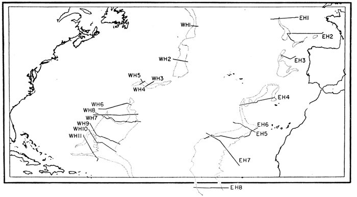
Figure 25.—Index chart, location of abyssal hills profiles illustrated in Figures 26 and 27
Limits of abyssal hills provinces shown by dotted lines.
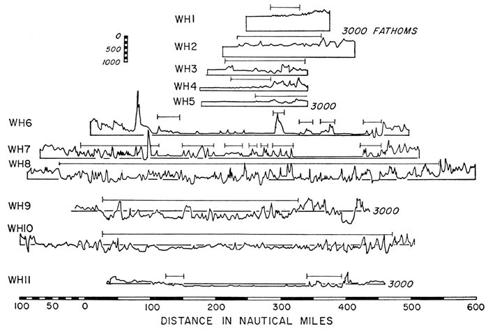
Figure 26.—Eleven profiles, Western Atlantic Abyssal Hills Province
40:1 vertical exaggeration; positions shown on Figure 25.
Abyssal hills are found along the seaward margin of most abyssal plains and probably occur in profusion in basins isolated from adjacent land areas by ridges, rises, or trenches. In the North Atlantic the abyssal hills form two strips parallel to the Mid-Atlantic Ridge for virtually its entire length. The Bermuda Rise is bordered on the southeast by abyssal hills which join with the strips adjoining the Mid-Atlantic Ridge (Fig. 25). Southeast of the Bermuda Rise the abyssal plain is absent, and consequently the Western Atlantic Abyssal-Hills Province exceeds 500 miles in width.
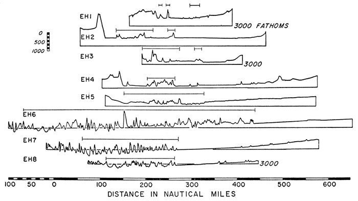
Figure 27.—Eight profiles, Eastern Atlantic Abyssal Hills Province
Vertical exaggeration 40:1; positions shown on Figure 25.
In the North Atlantic the axes of maximum depth on the eastern and on the western sides of the Mid-Atlantic Ridge lie in the abyssal-hills province. This pattern probably continues through the South Atlantic, Indian Ocean, and South Pacific oceans. Individual abyssal hills are identical to the smaller hills which rise from the steps of the Mid-Atlantic Ridge and are probably of the same origin. The abyssal hills and the Lower Step of the Mid-Atlantic Ridge can be distinguished topographically only by the contrast in level.
Regional description.—The abyssal hills within the area of the physiographic diagram are illustrated by profiles WH-1-11 and EH-1-8 reproduced in Figures 26 and 27 respectively.
WESTERN ATLANTIC: The abyssal-hills province ranges from a few miles to more than 125 miles in width from the north edge of the map to the Southeast Newfoundland Ridge. Along profile WH-1 the province consists of about a dozen hills 3-4 miles wide and 50-100 fathoms high, while in WH-2 the hills are 4-10 miles in width, and some exceed 200 fathoms in height. The abyssal-hills province appears to pinch out at the Southeast Newfoundland Ridge. Southwest of the Southeast Newfoundland Ridge the abyssal hills form a belt 60-120 miles wide which skirts along the north edge of Corner Rise. In this area, as illustrated by WH-3, -4, and -5, the largest abyssal hills nowhere exceed 250 fathoms in height. The individual hills range from 3 to 12 miles wide; maximum depths between individual hills frequently exceed the depth of the adjacent abyssal plain by 50-100 fathoms.
Along the northwest corner of Corner Rise the abyssal-hills province pinches out. South of Corner Rise the province appears on both the east and the west sides of the Sohm Abyssal Plain, and isolated abyssal hills become more numerous within the abyssal plain. In profile WH-6 the abyssal hills within the province reach 300 fathoms in height and are 3-5 miles wide. A few higher peaks occur such as the two in profile WH-6, one 500 fathoms high and 20 miles wide and the other 700 fathoms high and 15 miles wide. In addition eight isolated hills 100 to 175 fathoms high rise from the plain in the same profile. To the south, the frequency of hills within the plain increases, and the hills province widens. In profile WH-7 the province increases to 35 miles in width on the east side of the Sohm Plain and to 100 miles in width on the west side. The smaller individual hills in the plain are 200 fathoms high, in contrast to the average of 100 fathoms in WH-6. Twenty-one individual hills rise from the plain in WH-7, in contrast to 15 in WH-6. In WH-8 the abyssal plain is represented by a flat-floored valley only 12 miles wide; the remaining 500-mile width of the abyssal floor is occupied by abyssal hills. Individual hills are 300 to 600 fathoms high and 5 to 10 miles wide (Fig. 28; Pl. 10). If we filled all the depressions on WH-8 with 100 fathoms of sediments the profile would closely resemble WH-7.
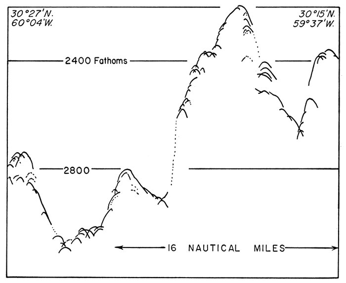
Figure 28.—Tracing of PDR record, abyssal hills, southeast of Bermuda Rise
WH-9 and WH-10 are very similar to WH-8 except that individual hills seem to become broader and lower toward the south. The height of individual hills in WH-10 ranges from 100 to 250 fathoms. South of WH-8 the abyssal-hill province splits into two strips which border the Nares Abyssal Plain. The western strip lies below the eastern scarp of the Bermuda Rise Scarp Zone, and the eastern strip follows the Mid-Atlantic Ridge, sending a narrow strip westward along the northern edge of the outer ridge north of Puerto Rico. A number of hills 50 fathoms high and 2-5 miles wide are scattered over the eastern part of the Nares Abyssal Plain. Abyssal hills are rare in the abyssal plain west of 65° W. The abyssal-hill province along the southwestern Bermuda Rise is extremely narrow and intermittent. No abyssal hills have been recorded for the Hatteras Abyssal Plain, and only locally is the province developed along the western side of the Bermuda Rise. Locally abyssal hills are moderately well developed along the northern margin of the Bermuda Rise.
EASTERN ATLANTIC: The abyssal floor west of the Anglo-French shelf is extremely narrow; the abyssal plain and abyssal hills combined are only 80 miles wide. The abyssal-hills province is absent, but, as shown on EH-1 and EH-2 (Fig. 27), large hills rise from the seaward edge of the Biscay Abyssal Plain. These hills are 5-10 miles wide and 100-400 fathoms high. West of the Iberia Abyssal Plain (EH-3) the abyssal-hills province is wider and better developed than near the Biscay Abyssal Plain.
South of Gibraltar the abyssal floor widens southward; northwest of Cape Verde it is more than 200 miles wide. Profile EH-6 runs obliquely through the province and indicates an exaggerated width for the province. Individual hills are 5-10 miles wide and 100-600 fathoms high (Pl. 9, fig. 4). The abyssal-hills province is widest, and the hills are the highest where the depth is greatest, a relation similar to that observed on the opposite side of the Mid-Atlantic Ridge in the sector southeast of the Bermuda Rise.
Origin of abyssal-hills topography.—The topography of the abyssal hills is considered to represent the original surface buried beneath the abyssal plains and perhaps beneath the continental rise. This explanation agrees well with the smooth topography and the distribution of deep-sea sands in the abyssal plain. The origin of the hills topography is a more difficult problem. We have no rock samples from these provinces. Individual hills cannot be studied with present seismic-refraction techniques; they do not seem to have a characteristic magnetic anomaly; and Worzel has only recently developed a method of gravity measurement which can be applied to a feature as small as an abyssal hill. At present we have only topography as a basis of speculation of their origin. As far as we know, individual abyssal hills are not discernibly different from the smaller hills of the steps of the Mid-Atlantic Ridge or much of the topography of the oceanic rises, and thus there is no reason to assume that the abyssal hills have a different origin.
We have noted that abyssal hills range from 50 to 600 fathoms in height and with some exceptions from 4 to 10 miles in width. However, many of the hills are about 200 fathoms high and 5 miles wide. The hills are very steep-sided, and frequently the sounder simply records a series of "highlights" from a succession of peaks (Pl. 10; Pl. 9, fig. 4). Soundings are difficult to obtain in the abyssal-hills provinces because of the great depth and primarily the preponderance of steep slopes (Pl. 10). We do not know whether individual hills are conical or elongate or, in fact, if they run in narrow, sinuous ridges as suggested by Tolstoy (1951). Accurate, detailed mapping of portions of the abyssal-hills provinces on scales of approximately 1:20,000 or larger should provide additional limits on theories of origin. At present we cannot decide among vulcanism, faulting, or folding, although folding seems the least probable.
OTHER MAJOR FEATURES OF THE ABYSSAL FLOOR
Abyssal gaps.—If two adjacent but distinct abyssal plains have no through passage at or below the level of the higher plain, they are said to be separated by a sill, a ridge, or a rise, depending on the dimensions of the feature involved. However, several plains are connected by constricted passages.
An abyssal gap is a constricted passage connecting two abyssal plains which, in the vicinity of the gap, lie at different levels. The sea floor slopes down continuously through the gap from the higher to the lower abyssal plain, at a gradient considerably greater than that of either adjacent abyssal plain.
Prominent abyssal gaps are known in the western North Atlantic (Vema Gap) and in the eastern North Atlantic (Theta Gap). An abyssal gap connects the Colombia and Venezuela abyssal plains of the Caribbean.
Mid-ocean canyons.—Whereas most submarine canyons are furrows cut into the continental-margin provinces, a class of canyon is found in the abyssal plains, generally associated with abyssal gaps.
A mid-ocean canyon is a steep-walled, flat-floored persistent linear depression, 1-5 miles wide and a few to more than 100 fathoms deep, which occurs in an abyssal plain.
Each mid-ocean canyon discovered in the North Atlantic leads to an abyssal gap in a manner which suggests a genetic relationship. All recognized mid-ocean canyons parallel the adjacent continental margin. Although all slope downward continuously they cut across the regional slope of the abyssal plain.
Mid-ocean canyons or features resembling them have been found in the Indian Ocean Bay of Bengal (Dietz, 1953), in the northwest Atlantic (Ewing et al., 1953), the western Atlantic, and the equatorial Atlantic (Beckmann, in preparation). Gibson (1958) has reported one in the Gulf of Alaska. Three in the Atlantic and one in the Gulf of Alaska have been mapped. Although mid-ocean canyons probably join with continental-margin submarine canyons, no such connection has been mapped. Menard (1955) has recorded from the North Pacific several crossings of features resembling the mid-ocean canyons of the Atlantic, which he refers to as deep-sea channels.
Regional description.—Abyssal gaps and mid-ocean canyons are found in both the western Atlantic and eastern Atlantic.
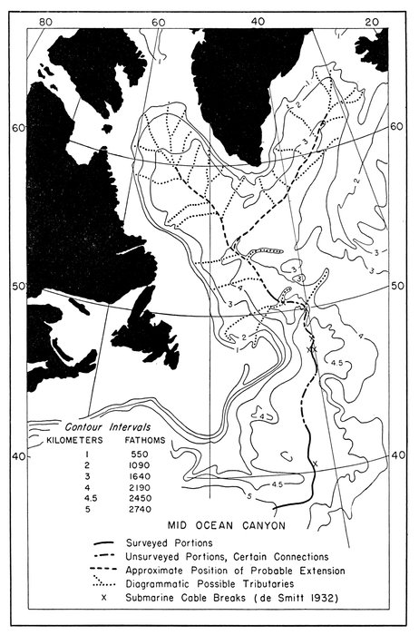
Figure 29.—Northwest Atlantic Mid-Ocean Canyon
Surveyed positions and extensions; generalized bathymetry simplified from Smith, Soule, and Mosby (1937)
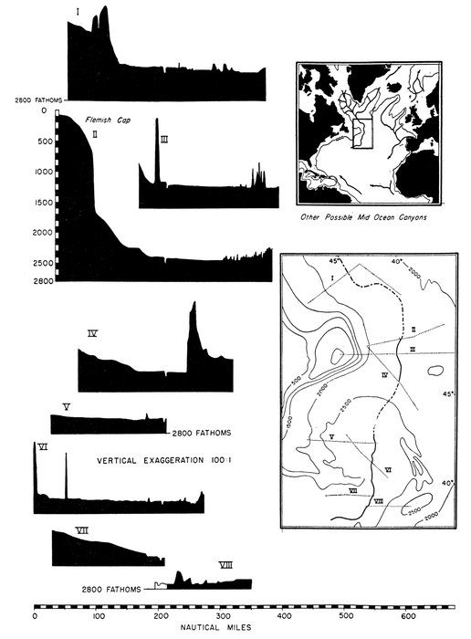
Figure 30.—Eight east-west profiles showing Northwest Atlantic Mid-Ocean Canyon
Soundings obtained with NMC sounder run with precision controlled ac power in 1949
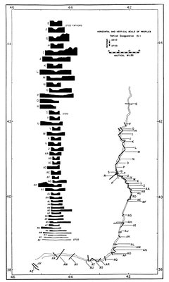
Figure 31.—Forty-eight cross sections of Northwest Atlantic Mid-Ocean Canyon
Soundings originally recorded on UQN-1B sounder with precision controlled ac power in 1952
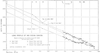
Figure 32.
—
Long profile of Northwest Atlantic Mid-Ocean Canyon
Numerals I-VIII indicate location of profiles of Figure 30.
WESTERN ATLANTIC: The major abyssal plains of the western Atlantic are connected from north to south by a series of abyssal gaps and mid-ocean canyons. The Northwest Atlantic Mid-Ocean Canyon (Fig. 29) begins in an unknown area north of the limit of the physiographic diagram (Ewing et al., 1953). It runs south parallel to the continental margin of the Grand Banks on the west and to the Mid-Atlantic Ridge on the east until it reaches the Southeast Newfoundland Ridge, where it cuts through a narrow abyssal gap. After passing through the gap, the canyon turns west, broadens, and is finally lost in the Sohm Abyssal Plain. The mid-ocean canyon is about 3 miles wide and 50 fathoms deep north of the Southeast Newfoundland Ridge (Fig. 30). The west wall is about 10-15 fathoms higher than the east wall (Fig. 32). The canyon has been mapped by more than 80 echo-sounding profiles (Fig. 31). The average slope of the sea floor at right angles to the axis of the canyon in most places exceeds the gradient of the canyon. The gradient west to east is about 1:1500, while the gradient of the canyon from north to south is 1:2250.
The mid-ocean canyon forms gentle meanders (Fig. 29). As the gradient of the canyon decreases, the canyon changes its cross-section form from a narrow, deep canyon to a broad, shallow one (Figs. 31 and 32).
The mid-ocean canyon follows an exceptionally narrow and deep abyssal gap through the Southeast Newfoundland Ridge. At its narrowest point the gap is no wider than the mid-ocean canyon.
Mid-Ocean Canyon No. 2 is nearly identical to the Northwest Atlantic Mid-Ocean Canyon in shape and form (Pl. 14, fig. 2). It has been traced for only 350 miles through the northwest arm of the Sohm Abyssal Plain. There is a strong suggestion of a low sill running northeast of the Bermuda Rise toward the "tail" of the Grand Banks. Such a sill would cut off the northwest arm of the Sohm Abyssal Plain. Mid-Ocean Canyon No. 2 would in this case be associated with this abyssal gap connecting the higher northwest arm with the deeper central and southern parts of the Sohm Plain. A large magnetic anomaly which crosses the plain at this point is possibly evidence of a buried ridge beneath the abyssal plain. Mid-Ocean Canyon No. 2 has been traced from the vicinity of Kelvin Seamount eastward to the supposed sill. As in the case of the Northwest Atlantic Mid-Ocean Canyon the gradient at right angles to the canyon axis generally exceeds the gradient of the canyon floor. A systematic difference in depth between the two walls was not found in Mid-Ocean Canyon No. 2.
A small area (8000 square miles) of abyssal hills lies between the northwest arm of the Sohm Abyssal Plain and the northern edge of the Hatteras Abyssal Plain. Although many sounding lines have been run through this area it is not yet clear whether this area is best referred to as an abyssal gap or a sill, although the evidence seems to favor a gap. The western end of the Sohm Plain seems to reach a smooth sill a few dozen miles east of Caryn Peak, and the abyssal plain surrounding Caryn Peak, at the mouth of the Hudson Canyon, seems either to be isolated or to be connected with the Hatteras Abyssal Plain to the south through an abyssal gap.
An abyssal gap may possibly connect Sohm Plain to the eastern end of the Nares Abyssal Plain, but in consideration of the eastward gradients of the Nares Abyssal Plain it seems probable that no gaps cut all the way through the wide abyssal-hills province which separates the two plains. The gap connecting the Hatteras Abyssal Plain and the Nares Abyssal Plain southwest of the Bermuda Rise has been named Vema Gap after the Research Vessel Vema which has been used most extensively in this area. Vema Gap is about 20 miles wide and 70 miles long; its long axis is oriented approximately west-east. The Hatteras Plain reaches a depth of 2900 fathoms a few miles west of the gap. The gradient of the plain is about 1:3000 at that point. The Nares abyssal plain to the southeast lies at about 3070 fathoms and slopes eastward with a gradient of about 1:3500. The floor of the gap, in sharp contrast to the adjacent plains, slopes eastward at an average gradient of 1:300. The edge of the Hatteras Abyssal Plain is cut by several mid-ocean canyons 20 fathoms deep and a mile wide which develop a few miles to the west and converge on the abyssal gap. Associated with Vema Gap is a large magnetic anomaly similar to the one observed near the supposed gap north of the Bermuda Rise, which again could possibly be evidence of a prominent buried ridge forming the sill of the gap.
The Old Bahama Channel Abyssal Plain and the Hispaniola-Caicos Abyssal Plain are probably connected by a steep-walled abyssal gap which runs west to east south of Great Inagua Island.
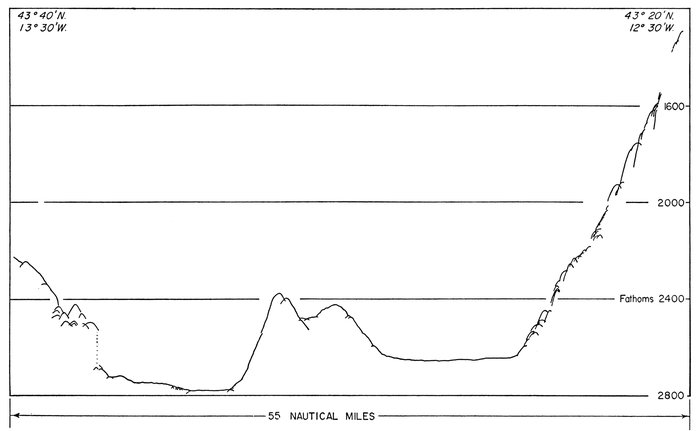
Figure 33.—Tracing of PDR record across Theta Gap
EASTERN ATLANTIC: The only abyssal gap known in the eastern Atlantic was sounded by M/V Theta and is here named Theta Gap. This gap lies off the northwest cape of Spain between the Biscay and Iberia abyssal plains. Its existence is based on only a few profiles, one of which is illustrated in Figure 33. Small depressions a few fathoms deep and 1-2 miles wide were observed in the Biscay Abyssal Plain and may represent mid-ocean canyons, which may possibly connect with Theta Gap (Pl. 8, fig. 2). Insufficient precision-sounding tracks are available in this area to determine the exact nature of these features.
Origin of abyssal-floor topography.—The explanation that abyssal plains represent portions of the abyssal floor buried beneath sediments transported by turbidity currents, and that the abyssal hills represent this unburied surface, has been offered by Heezen et al. (1951; 1954) and by Menard (1955). Abyssal gaps are pictured as passages through which turbidity currents flow from a higher plain to a lower one. Sediment must have filled in the Hatteras Plain to the present depth of the western end of Vema Gap before the Nares Abyssal Plain could begin to form. Ewing et al. (1953) suggest that the Northwest Atlantic Mid-Ocean Canyon was probably formed by turbidity currents which flow from the vicinity of Greenland to the Sohm Abyssal Plain. Whether the canyon-forming process was largely erosional or depositional remains to be seen, but the narrow, deep abyssal gap in the Southeast Newfoundland Ridge suggests erosion. The parallelism of the Mid-Ocean Canyon with the Mid-Atlantic Ridge even suggests a tectonic origin. The deep-sea sands of the canyon floor and its continuous gradient argue as strongly for a turbidity-current origin. The features of the smooth parts of the abyssal floor seem clearly the result of deposition by turbidity currents (Ericson et al., 1955; in press).
OCEANIC RISES
Definition and distribution.—An oceanic rise is a large area (measured in hundreds of miles), not connected to or included in a mid-oceanic ridge or connected to a continental rise, which rises a few hundred fathoms above the surrounding abyssal floor. The topography of an oceanic rise ranges from gentle to extremely rugged.
Included in this classification is the Bermuda Rise and Corner Rise of the North Atlantic, the Rio Grande Rise of the South Atlantic, and a number of similar but unnamed features in the Indian and Pacific oceans.
Regional description.—Only three oceanic rises are situated in the North Atlantic. They are: Bermuda Rise, Corner Rise, and Rockall Rise. Of these only the Bermuda Rise has been crossed by many echo-sounding traverses.
BERMUDA RISE: In the center of the North America Basin and surrounding the island of Bermuda is an oval asymmetrical arch about 300 by 600 miles with the long axis oriented northeast. The topography of the Bermuda Rise is relatively gentle as compared to the Mid-Atlantic Ridge but considerably more rugged than the continental rise (Pl. 27). The rise is usually distinctly marked on the west by a 10- to 100-fathom decrease in depth and a change from the monotonously smooth abyssal plain on the west to gently rolling hills, 20-50 fathoms high and 2-10 miles wide (Pl. 16). In contrast the eastern edge of the rise is marked by a series of scarps 300-900 fathoms high (Pl. 17), and the adjacent rise topography is relatively rugged. West of the scarp zone the topography is quite smooth to the western margin of the rise (Pl. 16).
An apron 30 miles wide surrounds the 2300-fathom high pedestal which supports the island of Bermuda (Pl. 20). From this apron Ericson, Ewing, and Heezen (1952), reported quantities of shallow-water-derived carbonate clastics.
North of Bermuda the rise is marked by a number of high seamounts which continue across the adjacent abyssal plain and form the Kelvin Group of seamounts. Many of these appear to be flat-topped.
The Bermuda Rise is bounded on the east and north by the Sohm Abyssal Plain, on the west by the Hatteras Plain, and on the south by the Nares Plain. For a short distance on the northwest and a few hundred miles on the southeast the rise is bordered by abyssal hills. The western edge of the Bermuda Rise is formed in places by a scarp, but particularly in the northwest the Bermuda Plateau seems to dip gently beneath the Hatteras Abyssal Plain.
The details of the topography of the Bermuda Rise are demonstrated by the series of radiating profiles in Plate 27.
Bermuda Pedestal.—The islands of Bermuda lie along the southeast rim of a flat-topped pedestal whose surface lies less than 20 fathoms below sea level. The sides of the Bermuda Pedestal slope at gradients of 1:5 to 1:30 and fall rapidly to the 2300-fathom contour where the base of the pedestal is reached. The pedestal is 50 miles by 80 miles at its base. Cores containing Tertiary sediments and recent reef detritus, and in one case basaltic rock, have been obtained from the sides of the Bermuda Pedestal (Pl. 28).
Bermuda Apron.—Encircling the base of the Bermuda Pedestal is a smooth, gently sloping apron or depositional terrace. The width of the apron is irregular and ranges from 40 miles on the east to 20 miles on the west. Gradients decrease to 1:700 away from the pedestal, but the outer edge of the apron in places has gradients of 1:90. On some profiles hills up to 125 fathoms in height occur near the outer edge of the apron and become increasingly numerous until at a distance of 45 miles from the pedestal the apron is not recognizable as a topographic feature. The limits of the apron will ultimately be defined by a study of the sediments.
Bermuda Plateau.—The Bermuda Plateau is an oval area of 90,000 square miles, which lies roughly in the center of the Bermuda Rise. The topography is characterized by low hills and rather extensive intermontane valleys (Pl. 16). Few individual hills exceed 50 fathoms in height. The topography of the sub-province is well illustrated in Plate 16. The depth is 2400 to 2700 fathoms. The plateau is bounded on the southeast by the Bermuda Scarp Zone. On the west it extends almost to the edge of the rise. On the north the Crescent Peaks and Muir Seamount Group have made it difficult to define the edge of the plateau.
Crescent Peaks.—Northwest of Bermuda a crescent-shaped line of conical peaks borders the Bermuda Apron. Individual peaks are 600 fathoms high and 4 to 6 miles wide at their base. This range of peaks forms a distinct sub-province which rises from the Bermuda Plateau.
Bermuda Scarp Zone.—The Bermuda Plateau is broken along its eastern margin by a series of scarps (Pl. 17). There appear to be two systems of scarps, one trending about N. 55° W. and the other about N. 35° E. Individual scarps range from 100 to 700 fathoms in height. The intersecting set of lines shown on the province chart (Pl. 20) indicates prominent scarps in this area. Dashed lines represent more speculative scarps. A further study of this interesting area is underway, and it is hoped that a more-detailed mapping of these scarps will be possible. Needless to say, dredging on these scarps should bring rich rewards in fossil sediments and igneous rocks which are undoubtedly exposed on these precipitous cliffs. The general character of the scarp zone is illustrated in Plate 17 by an echogram. There seem to be three or four major ne-sw scarps. In the east-central Bermuda Rise the areas between the scarp zones remain at virtually the same depth as the unfractured Bermuda Rise farther west. However, toward the southeast the inter-scarp areas drop as a series of steps. The depth along the base of each scarp is nevertheless deeper than the next lower step. The smaller topographic features of the southeast part of the scarp zone are very similar to the abyssal hills to the southeast and are thus probably of the same origin. The strips between successive scarps tend to shallow to the southeast and reach minimum depths just before the next scarp is reached.
Muir Seamount Group.—In 1945 workers on the U.S.S. MUIR discovered a large seamount 140 miles northeast of the Bermuda Islands. Subsequent reconnaissance surveys by the Lamont Geological Observatory (Tolstoy, 1951; Tolstoy and Ewing, 1949) revealed that the peak was asymmetrical in east-west profile (considerably steeper on the east) and that the seamount was elongate northeast-southwest parallel to the axis of the Bermuda Rise. Cores taken near its summit contained Eocene to Pleistocene sediment. Additional seamounts have been discovered in the area by Worzel and Shurbet (1955) and Northrop and Frosch (1954). The asymmetrical profile and the elongate shape parallel to the axis of the Bermuda Rise suggest that Muir Seamount is a tectonic uplift rather than a volcanic pile, but admittedly undersea vulcanism need not always produce symmetrical cones. As known, Muir Seamount is 35 miles wide (northwest-southeast), 60 miles long (northeast-southwest), and rises 1700 fathoms above the Bermuda Rise. The minimum sounding recorded is 846 fathoms. The Muir Seamount and near-by associated peaks apparently are not directly related to the Kelvin Seamount Group farther north. The north and northwest margin of the Bermuda Rise, like that on the west, is in some places a scarp and in other places a gentle transition. Near the northwest corner of the Bermuda Rise a range of hills each about 20 fathoms high and 3 miles wide follows the margin of the rise for many miles. The northeastern margin of the Bermuda Rise is abrupt in most places, and in some places a single scarp 500 fathoms high is all that separates the Bermuda Rise from the adjacent abyssal plain.
Sediments of the Bermuda Rise.—Most of the Bermuda Rise lies below the depth of 2500 fathoms, and thus the sediment ranges from foraminiferal clay through red clay with a predominance of red clay. In the vicinity of the Bermuda Pedestal calcareous detrital sediments have built a depositional apron around the base of the pedestal in depths of 2300 to 2450 fathoms (Pl. 28). The seamounts of the Bermuda Rise are rocky, as shown by photographs and bottom samples. Several cores from the Muir Seamount revealed a variety of Tertiary foraminiferal lutites. With the exception of the detrital sediments of the Bermuda Apron, the scoured crests and flanks of the larger seamounts, and the steeper scarps, the Bermuda Rise is covered preponderantly by pelagic sediments. This is in sharp contrast to the surrounding abyssal plain and near-by continental rise, where cores reveal frequent alterations of detrital and pelagic sediments (Pl. 28).
CORNER RISE: Much less extensive and less well known is Corner Rise which lies directly south of the Grand Banks on the east side of the Sohm Abyssal Plain. Corner Rise is so named because its northwest boundary with the abyssal floor forms a sharp, nearly right-angled corner (Pl. 20). The main part of Corner Rise is formed by a group of large, poorly surveyed seamounts. Several of the peaks rise to 1500 fathoms. The area is represented in profile I of Plate 22 (between mile marks 1000 and 1200). Photographs taken on Corner Seamount at the northwestern extremity of Corner Rise showed rippled and hard-clay bottom to 1200 fathoms. The fact that these seamounts apparently form a prolongation of the Kelvin Seamount Group suggests the need for detailed investigation of the latter seamounts and the probability that additional volcanic seamounts may be found along the same trend.
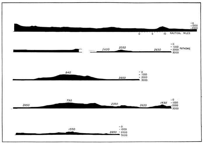
Figure 34.—Natural scale profile, Kelvin Seamount Group
ROCKALL RISE: Southwest of Rockall Bank between 19°W. and 23°W. on the 50th parallel, rising from the abyssal floor of the northeastern Atlantic, is an ill-defined area of irregular topography which seems not to belong to the Lower Step of the Mid-Atlantic Ridge. Little is known of this area, and its classification as a rise may not survive more detailed study. The area is illustrated in Plate 25 by profile E-1.
SEAMOUNTS OF THE OCEAN-BASIN FLOOR
A seamount is defined as any isolated elevation which rises more than 500 fathoms above the sea floor. Those seamounts which lie entirely on oceanic rises have been described as part of the rise topography. Now we will describe the seamounts of the abyssal floor.
KELVIN SEAMOUNT GROUP: An impressive row of large conical peaks runs from the vicinity of Georges Bank for 600 miles toward the northeast tip of the Bermuda Rise. A profile plotted at natural scale which crosses five of the largest seamounts is reproduced in Figure 34. The line of seamounts runs across the continental rise, abyssal plain, and the Bermuda Rise, seemingly little affected on crossing the province boundaries. The larger seamounts such as Kelvin Seamount are about 2000 fathoms higher than the adjacent plain and are as much as 35 miles in diameter at the base. Those which rise from the continental rise or the abyssal plain do so abruptly, suggesting that their bases are partially buried. The tops of most of these seamounts lie between 550 and 850 fathoms, and at least a few are flat-topped. They are thus very similar to the flat-topped guyots of the Pacific in size, shape, and the range of depths of their flat summits (Hamilton, 1956). Photographs taken on these seamounts showed rock, ripples and live solitary corals.
CARYN SEAMOUNT: A small conical peak, 1000 fathoms high, whose base is 8 miles in diameter, lies in the abyssal plain west of the Bermuda Rise (36° 45´N.). A magnetic survey of the peak has been published by Miller and Ewing (1956). They found an exceptionally large anomaly associated with the peak, which clearly showed its volcanic origin. Cores from the peak contained manganese nodules, altered volcanic rocks, and Upper Cretaceous to Recent fossils, which shows that it is at least as old as Upper Cretaceous. The base of the peak rises from the abyssal plain which extends out from the Hudson Submarine Delta.
HORSESHOE SEAMOUNT GROUP: About 300 miles due west from the Straits of Gibraltar an impressive group of seamounts lies in a horseshoe-shaped arc. Several of these, most notably Ampere and Josephine seamounts, rise to less than 100 fathoms. Josephine Seamount is the largest of the group and lies along an east-west topographic trend (the Azores-Gibraltar Ridge). In the southern half of the Horseshoe Group the individual seamounts appear to be coalescing cones similar to the seamounts of the Kelvin Group. Seamounts of the northern half, although imperfectly known, seem to be elongated east-west. The southern half of the group appears to resemble volcanic cones, while in the northern half tectonic deformation seems to have played a larger part. The seamounts have been cored, dredged, and photographed by a Lamont Observatory expedition. The sediments obtained from the seamounts are middle Tertiary to Recent (Sutton et al., 1957).
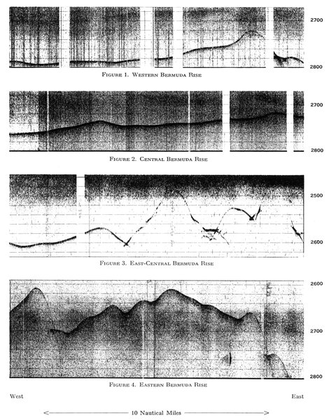
Figure 1. Western Bermuda Rise
Figure 2. Central Bermuda Rise
Figure 3. East-Central Bermuda Rise
Figure 4. Eastern Bermuda Rise
REPRESENTATIVE PDR RECORDS FROM BERMUDA RISE
Depth in fathoms.
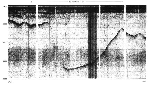
PDR RECORD, BERMUDA SCARP ZONE
Depth in fathoms.
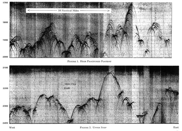
Figure 1. High Fractured Plateau
Figure 2. Upper Step
PDR RECORDS MID-ATLANTIC RIDGE
Depth in fathoms.
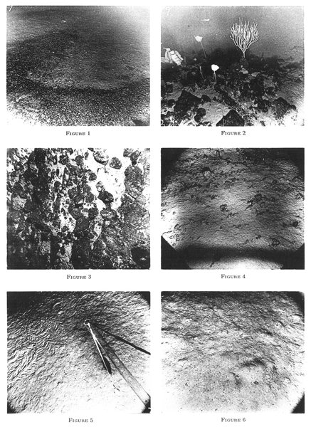
Area of each photograph is about 6 by 8 feet.
Plate 19.—OCEAN-BOTTOM PHOTOGRAPHS; MID-ATLANTIC RIDGE
Figure 1. (Station T1-9, photo 42) Depth 1410 fathoms, location 48° 38´N., 28° 48´W., on Western Rift Mountains, Mid-Atlantic Ridge. In this plate Figures 1, 2, and 3 are closely spaced photographs less than 100 feet apart.
Note the coarse-grained light and dark gravel in winnow row in the foreground and the light-colored clay or ooze bottom in background. Of the sixty photographs taken at this location three resembled Figures 2 and 3, several resembled Figure 1, and in the remainder the ocean floor was composed entirely of the light and dark gravel.
Figure 2. (Station T1-9, photo 43) Location about 50 feet from photo shown in Figure 1, same depth and position. The dark color of the rocks may be due to a coating of manganese dioxide. However, the rocks may actually be composed of dark material; no dredgings were taken here. All dredgings from Mid-Atlantic Ridge have brought up basalt and in some cases also gabbroic and serpentinized rock. It seems likely that the rock in Figure 2 and 3 of this plate is basalt. Note the abundance of sessile life on the rocky areas in contrast to its absence in the gravel-covered areas.
Figure 3. (Station T1-9, photo 45) Location about 100 feet from photo shown in Figure 2, same depth and position. Rock bottom on the Western Rift Mountains, Mid-Atlantic Ridge.
Figure 4. (Station V4-7, photo 27) Depth 500 fathoms, location 37° 25´N., 31° 10´W., Western Rift Mountains, Mid-Atlantic Ridge, south of the Azores Plateau.
Figure 5. (Station T1-54, photo 15) Depth 2100 fathoms, location 23° 07´N., 43° 45´W., Upper Step (eastern side), Mid-Atlantic Ridge. Apparatus in lower right attached to camera. Note tracks of crawling animal in left side of photo and small holes in bottom sediment. Photograph contrasts sharply with those from Rift Mountains in lack of current or oscillation ripples and rock outcrops.
Figure 6. (Station T1-14, photo 6) Depth 2130 fathoms, location 46° 04´N., 17° 43´W., Lower Step (eastern side), Mid-Atlantic Ridge. Note fecal pellets, mounds, and small holes. Again lack of evidence of strong currents or outcrops is notable.
Positions of stations shown on Plate 30
Photographs of the seamounts generally show winnowed and rippled sediment and rock (Pl. 15). Virtually all loose sediment is being removed from the seamounts. The horseshoe, open to the east, encloses an abyssal plain which is, judging from the sea-floor gradients, fed largely from the east by turbidity currents originating in the Straits of Gibraltar and the Gulf of Cadiz areas.
MILNE SEAMOUNT: Early charts of the western Atlantic showed an extensive bank of 20,000 square miles rising from the center of Newfoundland Abyssal Plain. At about the center of this area an exceptionally high peak has been discovered by cable ships, and the old name Milne Seamount has been assigned to this peak. It rises more than 2500 fathoms above the abyssal floor. Two seamounts of similar size have been found north and south of the Milne Seamount by workers on the R. V. Atlantis (Fig. 30).
As the abyssal floor is better surveyed many more isolated seamounts will undoubtedly be discovered, and they may reveal tectonically significant patterns.
SEISMICITY OF THE OCEAN-BASIN FLOOR
The ocean-basin floor provinces are virtually devoid of earthquakes of a size detectable at distant seismic observatories. Of course small earthquakes (< 5, Richter scale) would probably not be locatable in such remote regions. The virtual absence of larger shocks makes it improbable that many small ones occur there either. Two earthquakes have occurred in the Bermuda Rise, one near the west boundary and one in the scarp zone of the southeast Bermuda Rise (Pl. 29). Several quakes were felt in Bermuda before instrumental recording was available to permit location of their epicenters. Two quakes occurred in the abyssal plain northwest of the Cape Verde Islands, and two were located near Theta Gap northwest of Cape Finistere. All other earthquakes of the central part of the ocean basin are associated with the Mid-Atlantic Ridge or its eastern extension.
OCEAN-BASIN FLOOR PROVINCES AND CRUSTAL STRUCTURE
The results of seismic-refraction measurements in the ocean-basin floor can be divided into two categories depending on whether the measurements were made (1) in the abyssal floor, or (2) on an oceanic rise. Measurements in the abyssal floor of the western Atlantic (Ewing, Sutton, and Officer, 1954) revealed the simple pattern shown in Figure 35b and e—namely, that beneath 4-5 km of water lies .5-1 km of sediments and sedimentary rock with a compressional-wave velocity of about 2 km/sec, overlying 3-4 km of oceanic crustal rocks (6.5 km/sec); beneath this the sub-M mantle rocks show a velocity of about 8.1 km/sec. This pattern has been observed by most workers in the abyssal floors of other oceans (Raitt, 1957; Hill, 1956).
Officer, Ewing, and Wuenschel (1952) and Katz and Ewing (1955) have reported on the structure of the Bermuda Rise. The topographic change from abyssal floor to the Bermuda Rise is accompanied by a corresponding change in crustal structure (Fig. 35b and d).
A typical column measured on the Bermuda Plateau is shown in Figure 35d. Here the sub-M velocity appears to be lower, or possibly a new intermediate-velocity layer is inserted between the oceanic crust and the true mantle. In the Bermuda Rise seismic velocities in the oceanic crust differ somewhat from the typical abyssal-floor values. In the Bermuda Apron and adjacent parts of the Bermuda Plateau (Fig. 35c) above the oceanic crust a thick (up to 4 km) section of 4.5 km/sec velocity is found which has been quite reasonably identified as sedimentary and volcanic rocks.
Seismic-reflection measurements in the smoother parts of the ocean-basin floor fall into two general groups. Reflection records from the oceanic rises generally show a succession of reflections which can be correlated for considerable distances. Reflection records from the abyssal plains in general show many reflections which are usually impossible to correlate even between adjacent shots. This difference has been explained by Ericson, Ewing, and Heezen (1952) in terms of the distribution of turbidity-current deposits. In the abyssal plains relatively frequent turbidity flows have deposited an alternating sequence of clays and silts which return a great number of reflections to the reflection seismograph. In contrast the rises receive only pelagic sedimentation, and thus the layering of their sedimentary cover is simple and widespread since it relates to major changes in pelagic sedimentation of past geologic ages.
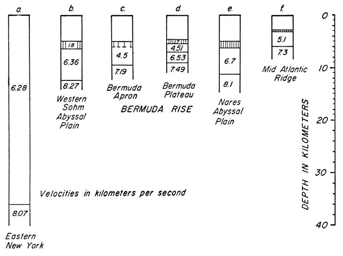
Figure 35.—Crustal sections in various physiographic provinces, determined by seismic-refraction measurements
(a). Eastern New York; Katz and Ewing (1955)
(b). Western Sohm Abyssal Plain; Station A 172-28, from Katz and Ewing (1955)
(c). Bermuda Apron; Station A 172-20 from Katz and Ewing (1955) and Officer et al. (1952)
(d). Bermuda Plateau; Station A 172-19, from Katz and Ewing (1955)
(e). Nares Abyssal Plain; personal communication from J. I. Ewing
(f). Mid-Atlantic Ridge; personal communication from J. I. Ewing