Part 2 — CONTINENTAL MARGIN
Reading edition
DEFINITION AND GENERAL CATEGORIES
The continental margin includes those provinces of the continents and of the oceans which are associated with the boundary between these two first-order features of the earth.
General categories.—In most areas three parallel categories of provinces can be distinguished in the continental margin (Fig. 10). The relatively flat portions of the submerged continental platform constitute category I. These provinces are: continental shelf, epicontinental marginal seas (e. g., Gulf of Maine), and continental-margin plateaus (e. g., Blake Plateau). The provinces of category II include the continental slope, marginal escarpments (e. g., Blake Escarpment), and the landward slopes of trenches. These provinces mark the edge of the continental block. Category III includes the continental rise, marginal trench-outer ridge, and marginal basin-outer ridge complexes.
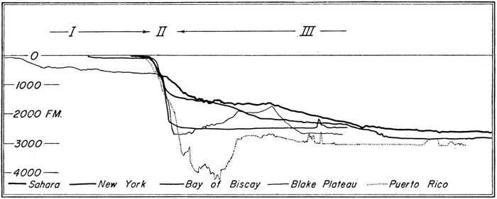
Figure 10.—Three categories of continental-margin provinces
Category I provinces lie on the continental block, Category II provinces form the side of the continental block, and Category III provinces are the upturned or depressed margins of the oceanic depression.
The most common type of continental margin is made up of continental shelf (I), continental slope (II), and continental rise (III). (Fig. 10, Sahara and New York). In areas where the continental rise is well developed it is composed of two parts, the upper and the lower continental rise (Fig. 15). In some areas the lower continental rise is replaced by an outer ridge, and the upper continental rise is replaced by a marginal basin or marginal trench. These two latter types are illustrated in Figure 10 by profiles marked Blake Plateau and Puerto Rico respectively. Seamounts and islands occur in all the continental-margin provinces.
Category I provinces.—The ocean overflows its basin onto the edge of the continents. The principal physiographic province of this submerged portion of the continental platform is the continental shelf which is present off all the lands of the world. The continental shelf is a smooth area with very low relief and is nearly everywhere limited to depths less than 250 fathoms. The continental blocks are also flooded by epicontinental seas. Some of these have rough bottoms, as the Gulf of Maine; others are relatively smooth-floored. Marginal plateaus, where present, lie in depths of 500-1200 fathoms, and many are nearly as smooth as the continental shelves.
CONTINENTAL SHELF: The continental shelf is a shallow (averaging less than 100 fathoms), gently sloping (less than 1:1000) surface of low local relief (less than 10 fathoms) which extends from the shore line to the shelf break where the seaward gradient sharply increases to greater than 1:40. Its width ranges from a few miles to more than 200 miles.
Continental shelves border all land areas. Because of their proximity to shore, their shallow depth, and their importance in navigation the continental shelves are now the best-known part of the oceans (Veatch and Smith, 1939; Shepard, 1948).
The transition from the continental shelf to the continental slope is generally abrupt and is known as the shelf break. This feature ranges in depth from 20 to more than 100 fathoms and in form from a sharp edge to a rounded shoulder. The change in the gradient is from less than 1:1000 to greater than 1:40.
EPICONTINENTAL MARGINAL SEAS: The epicontinental marginal seas are those shallow seas (less than 1500 fathoms) which lie on the continental block and can be distinguished from the continental shelves by their greater depth (usually > 100 fathoms) and possibly greater topographic irregularity. Most of them are enclosed by shallow banks (< 50 fathoms) of the continental shelf and by land. The Gulf of Maine, the Gulf of St. Lawrence, and the channels of the Bahamas belong to this class.
MARGINAL PLATEAUS: A marginal plateau is a shelflike feature which lies at greater depths than the continental shelf and is separated from the continental shelf by an incipient continental slope. These features generally lie at depths greater than 100 fathoms and less than 1200 fathoms. They can be distinguished from epicontinental marginal seas by their lack of a seaward barrier or sill. The surface of a marginal plateau is generally quite similar to the continental shelf in slope and in the frequency and magnitude of minor relief features. The Blake Plateau is the only well-expressed representative of this morphologic type in the area of the diagram. Well-developed marginal plateaus are also found off the coast of southern Argentina and east of New Zealand.
Category II provinces.—The steep slopes which border the continental block are grouped into category II provinces. Loosely speaking, we are referring to the continental slope but, because of the complications imposed by such features as marginal plateaus and marginal trenches, we distinguish three province types.
CONTINENTAL SLOPE: The continental slope is that relatively steep (3°-6°) portion of the sea floor which lies at the seaward border of the continental shelf. It typically drops from depths of 50-100 fathoms to depths of 750-1750 fathoms. The top of the slope is usually well marked by a relatively sharp shelf break. The base of the slope, although less definite, is generally abrupt. As a basis of classification in those few areas where no abrupt change is noted, we have set the gradient of 1:40 as the lowest gradient of the continental slope. The setting up of a lower limit for the gradient marks a departure from the older usage in which the continental slope was defined as "the slopes leading from the outer edge of the continental shelves down to the great depths of the ocean" (Shepard, 1948). This older definition included the continental rise, marginal plateaus, and marginal escarpments. The continental slopes are a world-wide phenomenon. The details of their regional distribution in the North Atlantic are covered in a later section.
MARGINAL ESCARPMENTS: A marginal escarpment is a precipitous escarpment which forms the seaward slope of a marginal plateau. Such escarpments begin in depths of 500-1500 fathoms and are 1000 to 2000 fathoms high. The base of the escarpment is well marked by an abrupt change in slope. Gradients of marginal escarpments exceed 1:10. The Blake Escarpment is a marginal escarpment. Similar features are found in the Gulf of Mexico and off the southeast coast of Argentina.
LANDWARD SLOPES OF TRENCHES: This term was introduced to set apart the landward slopes of marginal trenches from the usual continental slopes found off trench-less coasts. These steep slopes (> 1:40) drop from depths of a few hundred fathoms near a continent to a depth of a few thousand fathoms in a marginal trench. In the North Atlantic the one example is north of Puerto Rico. A large part of the circumference of the Pacific is bounded by such features.
Category III provinces.—At the base of the continental slope a gentle gradient continues to the local level of the abyssal floor. This seaward gradient ranges from 1:100 to 1:700 and extends over a strip from a few miles to a few hundred miles in width. On many topographic profiles made at right angles to the slope of the continental margin three major breaks are visible: the shelf break, the base of the continental slope, and the point where the near-by level of the ocean-basin floor intersects the more steeply sloping continental margin. Since we have limited the continental slope to gradients greater than 1:40, we split off this lower portion of the continental margin into a separate province, the continental rise. In the older "bathymetric" classification of relief the ocean basin—continental slope boundary was along the 2000- or 2500-fathom contour, an arbitrary division which cut across the then-unrecognized continental rise. At the base of the Blake Escarpment lies an enclosed basin, and north of Puerto Rico the sea floor drops almost directly to the floor of a marginal trench. These seemingly diverse provinces of continental rise, marginal escarpments, enclosed marginal basins, marginal trenches, and outer ridges are placed in category III because of their similarity in position with respect to the continents and ocean floor and because of other similarities shown in the deeper structure of the continental rise.
CONTINENTAL RISE: The continental rise, where present, lies at the base of the continental slope. Gradients on the continental rise generally range from 1:100 to 1:700, while the width ranges from a few score to a few hundred miles. However, gradients as high as 1:50 are observed in segment 3 of the upper continental rise, and gradients as low as 1:2500 are locally present in segment 2 of the lower continental rise (Tables 1 and 2). The seaward limit of the continental rise is generally abrupt, and at this point regional gradients decrease to less than 1:1000. The depth on the continental rise ranges from 750 to 2800 fathoms. Local relief is moderate to low, and, except for infrequent seamounts and fairly frequent submarine canyons, the local relief of the continental rise rarely exceeds 20 fathoms.
The continental rise is well developed over most of the area covered by the physiographic diagram. The major exceptions are north of the Iberian Peninsula where the rise is present, but extremely narrow, and in the southwestern third of the map in the area south of Cape Hatteras, where it is not present. In this latter area the geographical position usually filled by the continental rise is occupied by the low, broad outer ridge and the enclosed marginal basin and marginal trench.
OUTER RIDGE: An outer ridge is a broad ridge generally more than 100 miles wide that rises from less than 100 fathoms to about 1000 fathoms above the adjacent floor. It lies parallel to the continental margin and may enclose a basin or trench on the landward side. The local relief of an outer ridge is generally a little greater than that of the continental rise but much more subdued than that on the oceanic rises and mid-oceanic ridges.
MARGINAL BASIN: A marginal basin, where present, lies at the foot of the continental slope or at the base of a marginal escarpment. It is slightly shallower than the general level of the ocean basins and is bounded on the seaward side by an outer ridge. Part of its floor is generally occupied by an abyssal plain.
MARGINAL TRENCH: A marginal trench is a narrow, steep-sided feature running closely parallel to the trend of the continental margin; it is generally at least 1000 fathoms below the general level of the adjacent ocean floor. It is separated from the ocean floor by a low outer ridge which rises 100-500 fathoms above the level of the adjacent ocean floor. The bottom of a trench is generally rugged except near the deepest spots where it is flat.
The combination of marginal basin and outer ridge replaces the continental rise east of the Blake Plateau. North of Puerto Rico this combination is replaced by a marginal trench-outer ridge complex. The reason for this grouping is discussed in a later section.
Submarine canyons cut across all the continental-margin provinces except isolated portions of the outer ridge. Submarine canyons range from less than a mile to more than 10 miles in width and from less than 10 to nearly 1000 fathoms in depth. Canyons are most abundant on the continental slope. However, a smaller number persist across the continental rise. They are also found on the marginal escarpments and on the landward slopes of trenches. Shepard (1948), Kuenen (1950), Veatch and Smith (1939), De Andrade (1937), Johnson (1939), and others have discussed the continental-slope canyons at great length. Canyons in the continental rise of the North Atlantic were discovered and mapped by Ericson, Ewing, and Heezen (1951).
Heezen et al., PL. 2
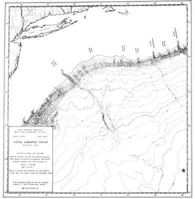
PRELIMINARY CHART OF HUDSON SUBMARINE CANYON Based on nonprecision coundings taken 1949-1050
REGIONAL DESCRIPTION OF CONTINENTAL MARGIN
This discussion is based on continuously recorded echo-sounding traverses made by Lamont Geological Observatory expeditions. Profiles approximately perpendicular to the continental margin are reproduced in Plates 24 and 25. None is precisely perpendicular, and thus slight distortions of slopes and widths of the features are unavoidable.
EASTERN NORTH AMERICA: Thirty-four profiles of the continental margin of eastern North America are presented in Plate 24. The positions of the profiles are indicated on the index chart in Plate 23. All profiles show the three categories of continental-margin provinces. Profiles W-1 to W-21 Plate 24 show the more general succession of shelf, slope, and rise, while profiles W-22 to W-34 show the outer ridge-marginal basin and outer ridge-marginal trench complexes. Each of the 34 profiles exhibits a continental shelf although it may range from 20 to 300 miles in width. On each a shelf break is present at depths of 20-150 fathoms. Each profile shows a continental slope, the base of which may be from 300 to 1900 fathoms deep.
Northern Grand Banks Sector.—On profiles W-1 to W-6 (Pl. 24), across the Grand Banks of Newfoundland, the shelf ranges from 120 to 285 miles in width. Exceptionally strong local relief of 50-100 fathoms is found on the shelf in profile W-1 northeastward from Newfoundland. The shelf break, which occurs at 150 fathoms, is abnormally deep—more than twice the depths found off New England. The continental slope has a typical gradient of 1:20 but is unusually short as the continental rise is reached at 725 fathoms. From this depth the continental rise descends to the 1700-fathom curve at a gradient of 1:140. This gentle slope is interrupted by a group of exceptionally rugged lower continental rise hills which rise to 1250 fathoms. Northeast of the hills the 2200-fathom line marks the rather abrupt beginning of the abyssal plain which slopes seaward at a gradient of 1:1100.
Flemish Cap.—Profile W-2 crosses the Grand Banks, along its widest east-west axis, and also the semidetached bank called Flemish Cap. The shelf is much smoother than in profile W-1, except for a small deep of about 100 fathoms immediately east of Newfoundland. The shelf break at 150 fathoms is followed by a continental slope 150 to 500 fathoms deep which has a gradient of 1:20. The Flemish Cap is a difficult feature to classify. It is too large to be a seamount and too shallow to be a marginal plateau. We must treat it as a part of the continental shelf, semidetached from the rest by a 650-fathom-deep channel. The eastern flank of the Flemish Cap slopes off at gradients of 1:100 and 1:60 until at a depth of 650 fathoms the bottom drops precipitously to 1750 fathoms at a gradient of 1:10. Seaward of this point an 85-mile-wide continental rise has a gradient of 1:65 and 1:250 down to the Newfoundland Abyssal Plain which is at a depth of 2400 fathoms. Twenty miles east of the continental rise this profile crosses the Northwest Atlantic Mid-Ocean Canyon.
On profile W-3 the shelf is quite smooth, and the shelf break is reached at 60 fathoms. The profile runs slightly oblique to the continental slope and reveals a series of submarine canyons. The base of the slope is at 1700 fathoms where the gradient drops to less than 1:200.
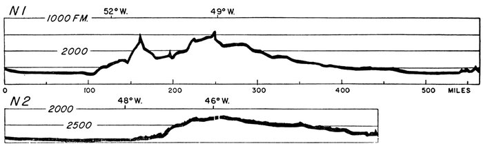
Figure 11.—Two east-west profiles of Southeast Newfoundland Ridge
Positions of profiles are indexed on Plate 23. Both profiles plotted from nonprecision soundings (NMC).
Southeast Newfoundland Ridge.—From the southern tip of the Grand Banks a broad ridge runs southeasterly toward the Mid-Atlantic Ridge and forms a natural barrier between the Newfoundland Basin and the North America Basin [to the south]. Since it is almost impossible to define a boundary between the continental rise and the ridge, we consider the Southeast Newfoundland Ridge an extension of the continental rise. The ridge is 60-100 miles wide, and its crest plunges southeastward from depths of 1500 fathoms near 50° W. to depths of 2200 fathoms near 45° W. Profiles N-1 and N-2 (Fig. 11) cross the Southeast Newfoundland Ridge at about 41.5° N. and 39.5° N. respectively. Profile N-1 is of poor quality, which probably accounts for the lack of fine-textured relief. The Mid-Ocean Canyon is again seen at the eastern end of Profile N-2. Profile W-5 (Pl. 24) crosses the Southeast Newfoundland Ridge from north to south. The similarity of profiles W-5 and W-23 suggests that the Southeast Newfoundland Ridge is an outer ridge of the same kind as the one east of the Blake-Bahama region. The northern one is not so long, and it does not totally enclose a basin. Otherwise, it is quite similar to the outer ridge east of the Bahamas in relative position, size, and surface features. The term Southeast Newfoundland Ridge was proposed by Wüst (1940b; 1943) and the feature has been shown on bathymetric charts (Tolstoy, 1951) and profiles (Emery, 1950). This ridge will be discussed again in connection with the Mid-Ocean Canyon and the ocean-basin floor.
Southern Grand Banks Sector.—Profiles W-4 and W-5 cross the southern tip of the Grand Banks. The shelf break is at 50 fathoms on both profiles. On Profile W-4 an apparent gradient of 1:25 extends from 200 to about 1000 fathoms where, after some irregularities probably associated with submarine canyons, the gradient drops to 1:40. This lower gradient extends to 1750 fathoms. Profile W-5 is quite similar to W-4 except that a steep initial slope of 1:5, from about 200 fathoms to 650 fathoms, is followed by a gradient of 1:80 which continues to 1000 fathoms. This same terracelike feature is also seen on W-3, W-4, W-5, W-6, W-7, and W-8. Below 1000 fathoms a gradient of about 1:50 is found on profiles W-4, W-5, W-6, W-7, and W-8. Profile W-6 runs south of the Grand Banks through the epicenter of the 1929 Grand Banks earthquake and then south through the area passed over by the 1929 Grand Banks turbidity current (Heezen and Ewing, 1952). The depression marked by the 1150-fathom sounding on the continental slope in Profile W-6 is a canyon running south from the Laurentian Channel. The continental rise is 250 miles wide and has an average gradient of 1:400 over its deepest third. At a depth of 2750 fathoms the gradient abruptly drops to 1:2000, and this marks the northern edge of the Sohm Abyssal Plain.
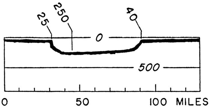
Figure 12.—Laurentian Channel
Profile replotted from NMC echogram
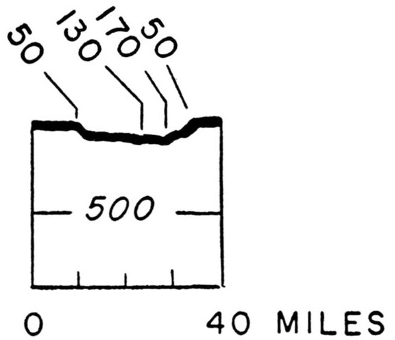
Figure 13.—Eastern Channel, Gulf of Maine
Profile replotted from NMC echogram
Laurentian Channel.—Between Nova Scotia and Newfoundland a 60-mile-wide, steep-sided, flat-floored channel cuts across the continental shelf connecting the Gulf of St. Lawrence and the open ocean. The nearly flat, smooth floor of this channel lies at about 230 fathoms depth. Figure 12 shows a cross-section of the Laurentian Channel near its seaward end. The origin and physiography of the channel has been treated by Shepard (1931; 1948); its structure has been reported by Press and Beckmann (1954). The Laurentian Channel continues as a steep-sided, box-shaped feature for more than 500 miles into the Gulf of St. Lawrence.
Scotian Shelf Sector.—The term Scotian Shelf was introduced by Canadian oceanographers and refers to the continental shelf southeast of Nova Scotia from the Laurentian Channel to the Gulf of Maine. This region is illustrated by Profiles W-7, W-8, W-9, W-10, and W-11 which run at slightly different directions, all starting in the vicinity of Halifax, Nova Scotia. Along the entire Scotian Shelf a series of 120-fathom depressions are located 10 to 80 miles off shore. A nearly continuous bank 20-60 fathoms deep and 10-25 miles wide lies along the seaward edge of the Scotian Shelf. From northeast to southwest this feature is divided by low saddles into Banquereau Bank (20-40 fathoms), Sable Island Bank (0-20 fathoms), Emerald Bank (40-60 fathoms), Lahave Bank (50-60 fathoms), and Browns Bank (20-60 fathoms). These shelf-edge banks culminate in the low, sandy Sable Island which stretches for about 25 miles along the outer edge of the shelf. In profile W-7 the break from the nearly flat shelf to a gradient of 1:50 occurs at 50 fathoms; a second break occurs at 80 fathoms. A gradient of 1:10 is reached at the 150-fathom curve. Profile W-11 is somewhat similar to W-7 in the form of the shelf break. Profiles W-8, W-9, and W-10 show shelf breaks at 50, 60, and 70 fathoms respectively.
The gradient of the continental slope off the Scotian Shelf ranges from 1:10 to 1:25 along the profiles. In profiles W-7, W-8, W-10, and W-11 the 1:25 gradient abruptly decreases to 1:70 at about 700 fathoms; in W-9 the 1:25 gradient continues to almost 2000 fathoms. It is difficult to decide whether to include the 1:40 to 1:60 segments with the continental slope or with the continental rise. However, since we have picked the gradient of 1:40 as the minimum gradient for true continental slopes, these segments fall within the continental rise. The continental rise thus defined averages 160 miles in width off the Scotian Shelf. Gradients are generally greater here than in the continental rise farther south. The "Gully", a large submarine canyon shown on navigational charts, lies about 25 miles east of Sable Island. The submarine canyons of the Scotian Shelf have not been accurately mapped, but the existence of many canyons in this area has been shown by several fathograms obtained in this vicinity. Figure 14 illustrates one sounding profile nearly parallel to the shelf near the "Gully". Several small canyons about 100 fathoms deep occur between 100 and 700 fathoms. Several larger canyons 300-500 fathoms deep and 7-10 miles wide are crossed on the lower continental slope and upper continental rise.
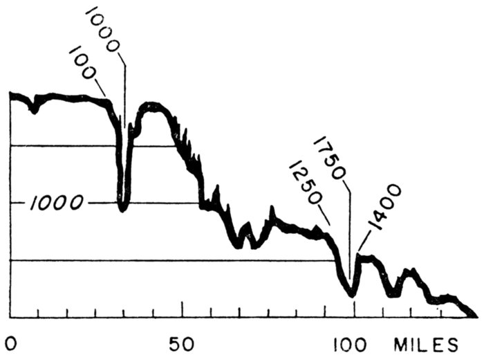
Figure 14.—Submarine canyons off the Scotian Shelf
Profile replotted from NMC echogram runs nearly parallel to trend of continental slope near Sable Island. On navigational charts largest canyon is known as the "Gully".
Gulf of Maine Entrance.—Southwest of the Scotian Shelf there is a narrow gap in the continental shelf similar to the Laurentian Channel. This feature, called either the Northeast Trough (Shepard, 1948) or Eastern Channel of the Gulf of Maine, is 15 miles wide and about 150 fathoms deep; it provides a deep-water entrance to the Gulf of Maine (Fig. 13). The Gulf of Maine is enclosed by Georges Bank off the New England shelf, Cape Cod, and southern Nova Scotia. This entrance has recently been described by Torphy and Zeigler (1957).
Gulf of Maine Interior.—Much of the interior of the Gulf of Maine has been surveyed in exceptional detail by the Coast and Geodetic Survey. The reader is referred to Murray's paper (1947) for a thorough description of the floor of the Gulf of Maine. In general the floor is extremely irregular with several 20- to 40-fathom "hills" per mile. The floor is covered by sediment which transmits sound so readily that the area is noted for exceptionally pronounced sub-bottom reflections from the rock layers beneath the sediment.
Northeastern United States Sector.—From the northeast tip of Georges Bank to Cape Hatteras the continental margin is remarkably uniform in morphologic detail. Profiles W-12 to W-19 differ very little from the type profile off northeastern United States (Fig. 15). The continental shelf and slope in this area are better surveyed than in any other area in the Atlantic. The surveys of the Coast and Geodetic Survey were contoured and described by Veatch and Smith (1939). The sediment studies of Stetson (1936; 1938; 1949) and the seismic studies of Ewing and others (1937 et seq.) make this geologically the best-known shelf and slope in the world. Many large and well-mapped canyons cut the continental slope from Georges Bank to Cape Hatteras. The large submarine canyons off Georges Bank have attracted great interest because of their remoteness from rivers and associated discharges of river sediments.
The continental shelf is 50 to 100 miles wide in this sector. Toward Cape Hatteras the coastal plain widens as the shelf narrows. The combined features are called the "emerged and submerged coastal plain." The gradient of the continental slope ranges from 1:8 to 1:15 and the base of the slope with one exception is at 1150 ± 100 fathoms. The shelf break is at about 50 fathoms on all profiles. On profiles W-12, W-13, W-14, W-15, W-18, and Figure 1 of Plate 4 there is a second break at 75-100 fathoms.
The break between the continental slope and the upper continental rise is abrupt at some places and occupies a distance of 5 to 10 miles in other places (Fig. 16). In each case the gradient of the next lower 30- to 50-mile segment is 1:100.
All profiles from Georges Bank to Cape Hatteras, a span of more than 500 miles, show both an upper and a lower continental rise (Profiles W-13, W-19, and Fig. 15). The uniformity in the continental slope gradient carries over into the continental rise. Both the upper continental rise and the lower continental rise are divided into three segments. The width, gradient, and depths of each of the slope segments are remarkably similar. Representative values based on profiles W-13 to W-19 and Figure 15 are shown in Table 1.
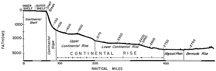
Figure 15.—Continental margin provinces: Type profile off northeastern United States.
Profile plotted from PDR records. This profile is representative of the sector from Georges Bank to Cape Hatteras.
Table 1.
—
Characteristics of the continental rise, northeastern United States sector: representative values of gradient, depth, and width of slope segments
Values measured from profiles W-13 to W-19
Depth
Segment Upper edge Lower edge Gradient Width
Upper continental rise
1 1150 ± 150 1450 ± 200 1:100 ± 20 30 ± 5
2 1450 ± 200 1650 ± 150 1:275 ± 25 40 ± 15
3 1650 ± 150 2150 ± 200 1:90 ± 30 30 ± 15
Lower continental rise
1 2150 ± 200 2350 ± 100 1:250 ± 50 40 ± 10
2 2350 ± 100 2350 ± 100 1:1400 ± 1000 50 ± 20
3 2350 ± 100 2725 ± 100 1:150 ± 30 60 ± 20
The upper continental rise and the lower continental rise are essentially terrace or shelflike features. Each has a relatively steep (1:50-1:200) outer face (segment 3) and a relatively gentle (1:250-1:2000) shelflike surface (segment 2). In each case a slope of intermediate gradient (1:80-1:300) (segment 1) connects the upper shelflike surface with the next higher face. In the case of the upper continental rise the next higher face is the continental slope. Other smaller-scale terracelike features may eventually be correlated along the strike when more data are available. The local relief exceeds 20 fathoms in the deeper parts of segment 3 of the lower continental rise. A range of hills extends for a few hundred miles along the base of the continental rise as indicated on the physiographic province chart (Pl. 20). These hills, known as the lower continental rise hills, are 30-100 fathoms high and each is 1 to 3 miles wide. An echogram (Pl. 3, fig. 4) shows three continental rise hills. The only other part of the continental rise where relief of more than 20 fathoms is generally encountered is in segment 1 of the upper continental rise. The irregularity in this case is probably related to the extensions of numerous continental-slope canyons onto the continental rise. Relief of 5-10 fathoms is almost universal in segments 1 and 2 of the upper continental rise. The echogram reproduced in Figure 1 of Plate 3 shows typical minor-relief features of the upper continental rise. An oblique crossing of a submarine canyon on the upper continental rise is shown in Figure 2 of Plate 3. The smooth topography typical of most of the remainder of the continental rise is well illustrated by the echogram shown in Figure 3 of Plate 3.
The Hudson Submarine Canyon cuts across the continental rise in this sector. A chart contoured by Ivan Tolstoy and the authors from surveys made in 1949 is shown in Plate 2 (Ericson, Ewing, and Heezen, 1951). A series of 30 cross profiles is shown in Figure 17.
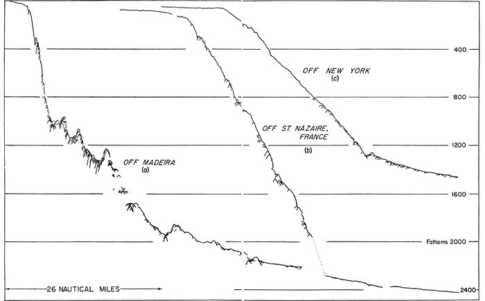
Figure 16.—Tracings of PDR records of continental and insular slopes
(a). Insular slope of Madeira southwest of Funchal.
(b). Continental slope of Europe.
(c). Continental slope off northeastern United States.
The Hudson Canyon, which is more than 500 fathoms deep and 5 miles wide in the continental slope (Upper Gorge), narrows to less than 2 miles and shallows to 50 fathoms at the base of the continental slope. As it cuts across segment 2 of the upper continental rise the canyon gradually deepens. When it cuts into the upper part of segment 3 the canyon deepens to 300 + fathoms, widens to 3 + miles, and forms the Lower Gorge. The canyon gradually narrows and shallows as it cuts across the lower continental rise. It ends near Caryn Peak where sediment cores indicate an extensive delta or submarine alluvial cone. The upper continental rise and the lower continental rise can be tentatively traced northeastward through the Scotian Shelf and Grand Banks sectors. The irregular bench at 2250-2450 fathoms on W-6 and the bench at 2300 fathoms on W-8 and W-11 can probably be referred to segment 2 of the lower continental rise.
Near Cape Hatteras the entire character of the continental margin changes. Benches which were barely discernible farther north widen to form a series of broad steps which resemble a giant staircase descending to the depths of the Atlantic. These benches appear to merge with the benches of the Blake Plateau and Escarpment farther south. However, insufficient profiles exist to permit a firm correlation.
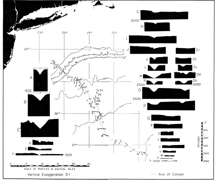
Figure 17.—Cross sections of Hudson Submarine Canyon
Replotted from nonprecision soundings (NMC) made 1949-1950
Blake Plateau Sector.—This sector is divided into two parts, the northern part from Cape Hatteras to 29° N. (essentially a transition zone) and the southern or main Blake Plateau between 29° N. and the northern edge of the Bahamas at 26° N.
The shelf break lies parallel to the coast, about 60 miles offshore, from just south of Cape Hatteras to Cape Canaveral. The continental slope extends (at a gradient of 1:40) only to depths of 300-400 fathoms where the lower gradients (ca. 1:1000) of the Blake Plateau are found.
The main or southern Blake Plateau is 170 miles wide (east-west) and extends from the latitude of Grand Bahama Island to 30° N. From this point to Cape Hatteras the Blake Plateau narrows and disappears. The Blake Escarpment forms a precipitous drop to abyssal depths along the eastern edge of the plateau. The top of the Blake Escarpment lies at about 550 fathoms, and its base at about 2600 fathoms. The Escarpment is typically formed by two or three distinct slope segments.
An echogram obtained along a track running southeast from Charleston, South Carolina, is reproduced in Figure 1 of Plate 7. The continental shelf extends from the shore at an extremely low gradient to the 25-fathom isobath where a small definite notch marks an increase in gradient to 1:1000. This gradient continues to the 50-fathom isobath where it changes to 1:40. At the 90-fathom curve the gradient increases to 1:120 and continues to 160 fathoms where it finally increases to 1:40. This continental slope drops from 160 fathoms to 280 fathoms where the gradient flattens, and the surface changes from smooth to rough, with hills 10 to 20 fathoms high and half a mile to 1-½ miles wide. These hills, which extend for 4-6 miles along the profile, directly underlie the Gulf Stream.
For 50 miles seaward of these hills the ocean floor is irregular between 230 and 300 fathoms. At 90 miles from shore five eastward-facing scarps 10-20 fathoms high form a striking contrast to the generally smooth, gently rolling topography. At 300 fathoms the gradient increases to 1:200, and the sea floor drops for the next 24 miles to 400 fathoms where a few small hills are associated with a drop in the gradient to 1:1000. Southeast of this point the bottom is smooth until at a depth of 430 fathoms a steep scarp drops abruptly 30 fathoms to form a mile-wide depression 20-30 fathoms deep. The southeast side of this feature rises to 445 fathoms, and southeastward of a few 5-fathom scarps the surface of the Blake Plateau becomes smooth.
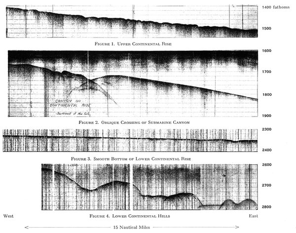
Figure 1. Upper Continental Rise
Figure 2. Oblique Crossing of Submarine Canyon
Figure 3. Smooth Bottom of Lower Continental Rise
Figure 4. Lower Continental Hills
REPRESENTATIVE PDR RECORDS FROM CONTINENTAL RISE OF NORTHEASTERN UNITED STATES
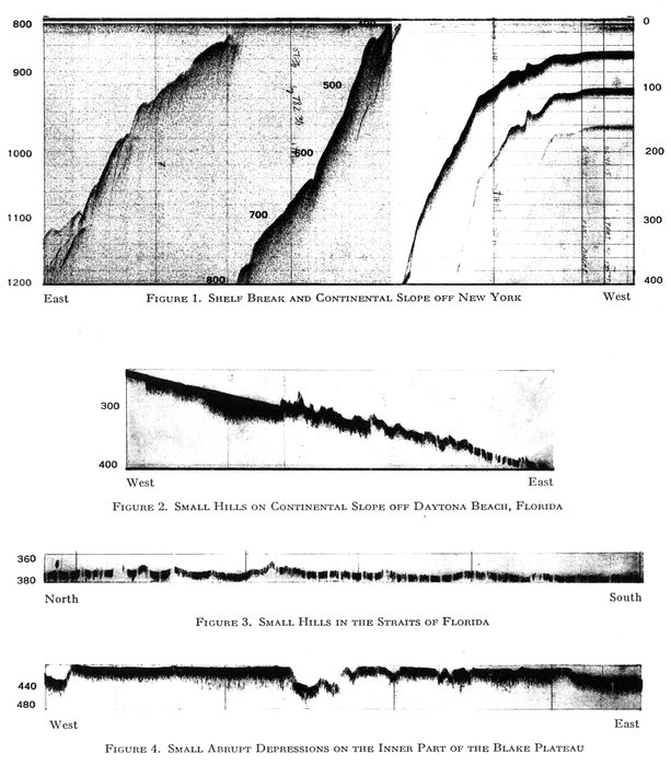
Figure 1. Shelf Break and Continental Slope off New York
Figure 2. Small Hills on Continental Slope off Daytona Beach, Florida
Figure 3. Small Hills in the Straits of Florida
Figure 4. Small Abrupt Depressions on the Inner Part of the Blake Plateau
PDR RECORDS FROM CONTINENTAL SLOPE AND BLAKE PLATEAU
The positions of all echo-sounding records are shown in Plate 30. Depth in fathoms.
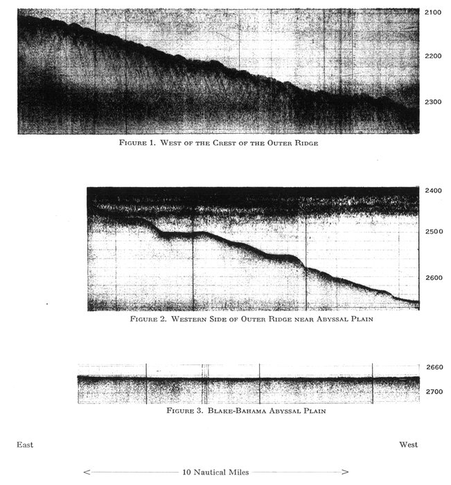
Figure 1. West of the Crest of the Outer Ridge
Figure 2. Western Side of Outer Ridge near Abyssal Plain
Figure 3. Blake-Bahama Abyssal Plain
PDR RECORDS FROM OUTER RIDGE EAST OF THE BLAKE PLATEAU AND FROM THE BLAKE-BAHAMA ABYSSAL PLAIN
Depth in fathoms: The outgoing "pings" as well as "scattering layers" are recorded in the 0-400 fathom scale range; the bottom topography may lie within the range of any multiple of 400 fathoms. The depth scales indicated on the plates refer to the profiles of bottom topography. For example—Figure 1 of Plate 5 shows a 300 fathom deep "scattering layer" over which the bottom profile has been superimposed.
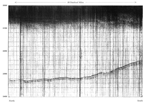
PDR RECORD OF OUTER RIDGE SHOWING SUB-BOTTOM HORIZON
One 3 millisecond ping was transmitted and received once each second. Depth in fathoms.
The same general succession of topographic features is shown in a echogram (Pl. 7, fig. 2) taken along a southeast-northwest line east of Daytona Beach, Florida. The small definite notch at 26 fathoms is present, but a significant difference between the two echograms is seen between 90 and 300 fathoms. On the Charleston profile a steep 1:40 gradient slope marks this depth range, while, on the Daytona Beach profile, the gradient is relatively gentle (1:180); small but probably significant benches are found at 225, 270, 290, 375, and 385 fathoms. Both profiles have the same characteristic rugged 5- to 15-fathom hills at 400 fathoms at a point underlying the Gulf Stream. On the Charleston profile a broad, gently fractured arch separates the continental slope from the smooth outer part of the Blake Plateau. The small, sharp-crested hills noted on the Daytona Beach and Charleston profiles are also found at the north end of the Straits of Florida (Pl. 4, fig. 2).
Blake Escarpment.—Profiles W-23, W-24, and W-25 and Figure 18 illustrate the form of the Blake Escarpment. The outer edge of the Blake Plateau abruptly breaks off at about 600 fathoms. Here gradients increase to 1:30. This segment continues with a few minor breaks to a depth of 1200 to 1500 fathoms where a narrow bench or at least a major break in slope occurs. Below this bench the escarpment drops so steeply that only a few side echoes are recorded. The gradient here exceeds 1:2 in several profiles. At 2400 fathoms there is in places another narrow bench, but on other profiles the abyssal plain of the floor of the Blake-Bahama Basin lies directly at the foot of the steepest segment. A peculiar fact is that along many east-west cross sections the deepest point in the basin lies directly at the foot of the escarpment. A similar deepening adjacent to the Campeche and West Florida escarpments in the Gulf of Mexico has been reported (Ewing, Ericson, Heezen, 1958).
Antilles Outer Ridge.—South of Cape Hatteras a ridge ranging in width from 60 to 200 miles lies about 100 miles east of the Blake Escarpment and the Bahama Banks. The ridge has two parallel crests 100 miles apart which both plunge to the south. At 30°N. the crests average about 1600 fathoms in depth, but at 25°N. they are 2750 fathoms, a drop of nearly 1000 fathoms in 300 miles. The smooth rolling topography of the ridge between Cape Hatteras and 24°N. resembles the continental rise off New York or, in some areas, the somewhat stronger relief of the Bermuda Plateau of the central Bermuda Rise (Pl. 5, figs. 1, 2).
South of 24°N. and in the vicinity of Hispaniola the ridge is poorly known and difficult to study because of its low relief and the large errors in most nonprecision soundings taken in such a great depth of water. North of Puerto Rico the outer ridge appears as a clearly defined feature between the Puerto Rico Trench on the south and the Nares Abyssal Plain on the north. Again there are two parallel crests 60 miles apart marked by low relief of 20 to 100 fathoms at a depth of 2750 fathoms.
The Antilles Outer Ridge, continuing to the east, merges with the Lower Step of the Mid-Atlantic Ridge. But more probably it skirts the Lesser Antilles to join the continental rise off South America. The crest zone is covered by Globigerina ooze in the north and red clay in the south; it is isolated from the silty clays of the continental slope except on its northwest flank. Sub-bottom echoes appear on fathograms taken across the outer ridge. Data suggest that a prominent 8- to 10-fathom sub-bottom interface extends over the outer ridge between San Salvador and 30°N. (Pl. 6).
Bahamas Sector.—The Bahamas sector can be divided into two parts: (1) the broad (200 miles wide) northern area dominated by broad, shallow banks broken by relatively narrow, deep (ca. 1000 fathoms) tongues or channels; (2) the narrow southeastern part where the banks decrease in area and the tongues deepen (to 2200 fathoms) and widen. This southeastern part tapers to the east in the direction of the Puerto Rico Trench. The southeast tip of this area is formed by Navidad Bank, whose eastern slopes drop to the floor of the Puerto Rico Trench.
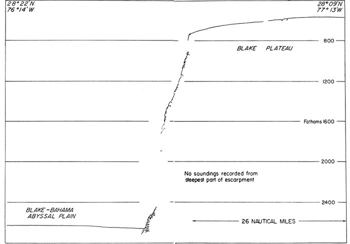
Figure 18.—Tracing of PDR record of Blake Escarpment
No soundings were recorded between 1600 and 2400 fathoms, a common difficulty on this precipitous escarpment. Note how Blake-Bahama Abyssal Plain slopes toward the base of the escarpment.
The Bahama Banks appear to consist of a slab superimposed on the same surface which forms the Blake Plateau. The Blake Escarpment merges with the lower part of the eastern slope of the Bahamas. The slopes of the Bahamas are precipitous; gradients are of the order of 1:4 to 1:8. Vertical cliffs, which lie just below the 50-fathom curve, have been reported by lead soundings (Armstrong, 1953). The Tongue of the Ocean and the Northeast and Northwest Providence channels form a network of submarine canyons (Hess, 1933). The floor of this canyon system has a continuous down-slope gradient to the floor of the Blake-Bahama Basin. Sediment cores from the floor of the Blake-Bahama Basin (2525 fathoms) (Ericson, Ewing, and Heezen, 1952) contained thick (1-3 m) beds of graded calcareous sand. The steep slopes of the Bahamas are generally rocky, and cores here reveal a variety of Tertiary and Cretaceous sediments. Exuma Sound also is linked by submarine canyons to the Blake-Bahama Basin. The graded calcareous sands of the Blake-Bahama Basin were probably carried through this submarine canyon system by turbidity currents. The topographic benches of Exuma Sound have been described by Lee (1951).
The southeastern Bahamas from Great Inagua to Navidad Bank consist of more numerous isolated banks and greater expanses of ocean floor in the depth range of 1700-2400 fathoms. The basins behind the southern Bahamas lie below the sill depth between the line of banks. Thus an abyssal plain lies entrapped in the Hispaniola-Caicos Channel and the southeastern portion of the Old Bahama Channel. Profile W-29 (Pl. 24) shows much irregular relief between 1000 and 1500 fathoms.
Puerto Rico Trench Sector.—With the disappearance of the Bahama Banks at the eastern edge of Navidad Bank, the continental margin assumes its third mode of expression: the marginal trench-outer ridge complex. The outer ridge, which nearly disappeared in the southeastern Bahama sector, again becomes a prominent feature. The last traces of the marginal plateau merge with the continental slope of Hispaniola and Puerto Rico. The Puerto Rico Trench develops rapidly east of Navidad Bank; it lies between the outer ridge and the continental slope or landward trench slope of the Greater Antilles. The relief of the outer ridge is somewhat greater than that observed on the outer ridge farther northwest near the Blake Plateau. The floor of the Puerto Rico Trench is divided into two parts by a longitudinal ridge. The deepest parts of both are floored by nearly level trench plains. The deeper one on the outer or northern side maintains a nearly constant depth at 4358 fathoms (4585 fathoms corrected) for 150 miles (Ewing and Heezen, 1955). The southern or inner trench is more variable in depth, and the trench plain lies intermittently along its length. Its depth ranges from 3600 to 4300 fathoms (uncorrected). The walls of the Puerto Rico Trench are formed by a series of extremely steep segments which show a remarkable persistence along the trench. Profiles W-32 and W-33 illustrate the typical trench profile north of Puerto Rico. Breaks in slope are observed at 700 fathoms and at 1500 fathoms; at 2000 fathoms the gradient steepens to > 1:6. In this region all soundings are side echoes. The outer or seaward wall of the trench is also characterized by a succession of laterally persistent slope segments. A bench at 3800 fathoms at the top of a scarp which drops to the bottom of the trench is characteristic of several profiles.
Anegada Passage.—The Virgin Islands Bank extends 30 miles east of Puerto Rico along the south side of the Puerto Rico Trench. Between the Virgin Islands Bank and St. Croix a deep passage cuts through from the Atlantic to the Caribbean. This deep passage is 130 miles long and runs along an e-ne-w-sw line. Its walls are extremely steep (9°-43°) (Frassetto and Northrop, 1957). The structure of this feature has been studied by Shurbet and Worzel (1957) and by J. Ewing et al. (1957).
Heezen et al., PL. 7

TRACINGS OF PDR RECORDS ACROSS CONTINENTAL SLOPE AND PART OF THE BLAKE PLATEAU
SOUTHWESTERN EUROPE AND NORTHWEST AFRICA: The continental margin of Europe and Africa is illustrated in Plate 25 by only 23 profiles, and therefore our description of this area cannot be as detailed as that for North America. For purposes of description we have broken the area into four sectors of contrasting type: (1) the Anglo-French sector: (2) the Iberian sector; (3) the Gibraltar sector; and (4) the North African sector. In all but the three profiles in the Gibraltar sector there is a well-defined continental shelf. The continental slope is everywhere present but ranges widely in height and gradient. The continental rise is extremely well developed off Africa but virtually absent in the Bay of Biscay. Abyssal plains are shown on almost every profile, but their depth ranges from 2550 to 3075 fathoms, and their width from 50 to 250 miles.
Anglo French Sector.—Profiles E-1, E-2, and E-3 are representative of the Anglo-French sector which extends from 45° N. to 60° N. Only the southern part of this sector is shown on the physiographic diagram. The continental slope is broken by a prominent bench or marginal plateau at 1000-1200 fathoms. The northwest corner of the physiographic diagram south to 42° N. is included in Hill's (1956) contour chart. According to this chart the prominent 1200-fathom bench extends for more than 900 miles along the continental margin from 45° to 60° North Latitude.
The continental slope from the shelf break to the prominent bench exhibits smaller benches and changes in slope, many of which probably will be correlatable when more profiles are obtained in this region. The general gradient of this portion of the slope ranges from 1:10 to 1:30. On the bench individual slope segments range from 1:40 to 1:80. Below the bench the sea floor drops from 1500 to 2100 fathoms at gradients of 1:15 to 1:30.
In profiles E-1 and E-3 a narrow continental rise about 70 miles wide with gradients of 1:250 to 1:800 lies at the foot of the continental slope. This narrow continental rise (Pl. 8, fig. 1) gives away to a 60-mile-wide abyssal plain at about 2500 fathoms depth (Pl. 8, fig. 3). Abyssal-plain gradients are about 1:2000 in this region. Toward the southeast corner of the Bay of Biscay the 1000- to 1200-fathom bench disappears (Fig. 16b); the continental rise and continental shelf narrow to 30 miles. We have only two profiles off the north coast of Iberia, but Hill's (1956) chart suggests that the slope is relatively steep with some prominent benches, and that the continental shelf and continental rise narrow to 10 to 15 miles in width. The prominent Cape Breton Submarine Canyon lies at the southeast corner of the Bay of Biscay (Bourcart, 1949).
Iberian Sector.—This sector was described by De Andrade (1937) on the basis of a large number of discrete soundings by the Portuguese Hydrographic Service. Relatively few echo-sounding profiles are available for the area, and little more can be added to De Andrade's description. The shelf in most places is less than 20 miles in width. The few echo-sounding profiles available indicate several prominent benches on the continental slope. Exceptionally large submarine canyons occur off Cape St. Vincent, Setúbal, Lisbon (2), and Nazaré. Preliminary investigations by the Lamont Geological Observatory indicate that Tertiary sediments outcrop on the walls of Lisbon and Setúbal canyons (Sutton et al., 1957). Tertiary sediments have also been obtained by dredging and cable grappling along the continental slope of northwest Iberia (Wiseman and Ovey, 1950).
Gibraltar Sector.—The continental margin in this sector is unique. The straits cut through at about 200 fathoms so that profiles through the straits show no continental shelf. A typical abrupt continental slope is also absent since only locally do slope segments have gradients exceeding 1:45. A series of prominent benches is seen in the sector from profile E-7 to E-10.
The dominant bench levels in this sector are 300, 600, 850, 1300, 1700, and 2100 fathoms. Insufficient profiles and dredgings are available in this area to permit the correlation and dating of these benches. Photographs in the area show sandy and rocky bottom, and thus dredging in this area might yield rich rewards in ancient sediments. The benches are so prominent that a detailed study of the topography should be equally rewarding. Of particular interest is the manner in which the broad benches in the Gibraltar area merge with the smaller benches and breaks in slope of the steep continental slopes of Portugal and Algeria. The topography in this sector most closely resembles that of the northern Blake Plateau (profiles W-21, W-22) and the northern part of the Anglo-French sector. In all these areas many benches are developed, and steep slopes are only locally developed.
Northwest African Sector.—The continental margin from northwest Morocco to Dakar is remarkably uniform and rather closely resembles the northeastern United States sector. The continental shelf and slope are well developed (Fig. 19). The shelf is 15 to 70 miles in width and thus is somewhat narrower than either the North American shelf or the Anglo-French shelf. The shelf break ranges from 50 to 80 fathoms. The continental-slope gradients range from 1:15 to 1:40 and are thus somewhat less steep than in the American sectors. Prominent benches are common at 300, 600, 850, 1200, and 1600 fathoms. The continental rise is well developed and is compound. The main contrast between the North African and American sectors is the greater width of the African continental rise. Off northeastern United States a line of isolated volcanic peaks cuts across the continental rise and abyssal plain. In the North African continental margin volcanic peaks are larger, more numerous, and lie in coalescing lines or along ridges. The Cape Verde and Canary groups lie in the continental rise near the outer edge of the upper continental rise. All provinces except the continental shelf widen from Gibraltar southward toward Cape Verde.
On profile E-11 off Casablanca the distance from the shelf break to the lower continental rise is only 50 miles as compared with a similar measurement of 500 miles at Cape Verde. Off Casablanca the continental slope extends to 1400 fathoms where the gradient drops to less than 1:40 from 1:10-1:20 on the continental slope. The upper continental rise which widens to more than 100 miles farther south is only poorly developed off Morocco. No other deep-sea echo-sounding profiles are available for the Moroccan continental margin. Surveys of the continental slope made by the French Hydrographic Service during the past few years will, when published in full, undoubtedly provide much valuable information on the topographic benches in this important area (Grousson, 1957).
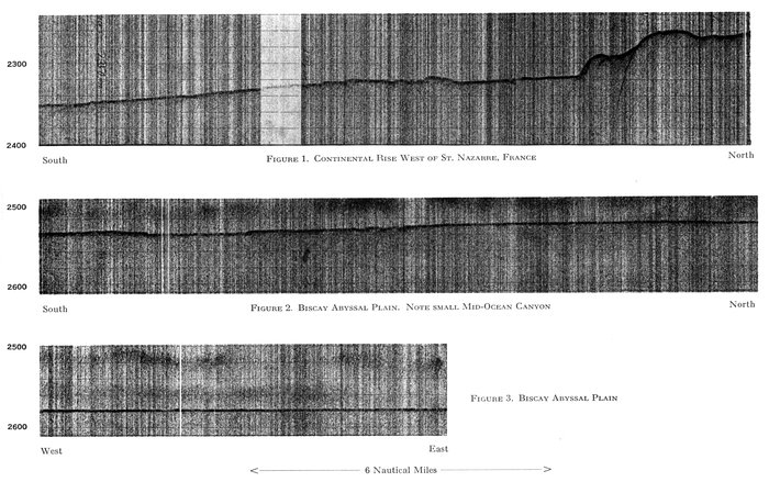
Figure 1. Continental Rise West of St. Nazaire, France
Figure 2. Biscay Abyssal Plain. Note Small Mid-ocean Canyon
Figure 3. Biscay Abyssal Plain
PDR RECORDS EUROPEAN CONTINENTAL RISE AND BISCAY ABYSSAL PLAIN
Depth in fathoms.
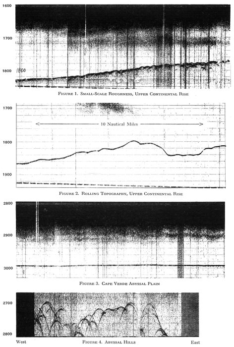
Figure 1. Small-Scale Roughness, Upper Continental Rise
Figure 2. Rolling Topography, Upper Continental Rise
Figure 3. Cape Verde Abyssal Plain
Figure 4. Abyssal Hills
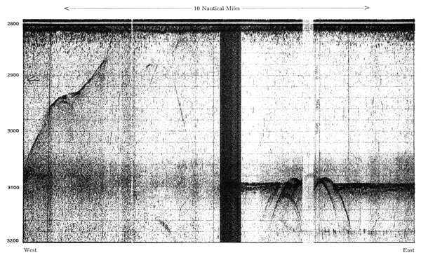
PDR RECORD OF ABYSSAL HILLS, SOUTHEAST OF BERMUDA RISE
Note sub-bottom echos from beneath intermontane basin floor. Depth in fathoms.
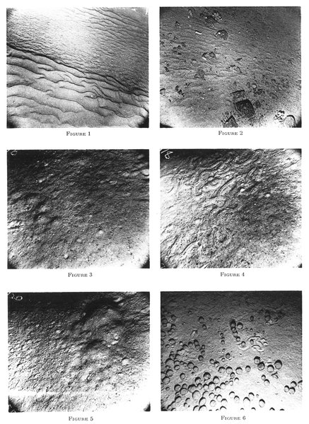
Area of each photograph is about 6 by 8 feet.
Plate 11.—OCEAN-BOTTOM PHOTOGRAPHS ON THE CONTINENTAL MARGIN AND OCEAN-BASIN FLOOR
Figure 1. (Station T1-3, photo 27) Depth 260 fathoms, location 47° 42´N., 07° 34´W., just below shelf break west of St. Nazaire, France. Note small ripples which appear to be superimposed on larger ripples.
Figure 2. (Station T1-3, photo 7) Depth 285 fathoms, location several hundred feet from photograph in Figure 1. Note holothurians and solitary coral attached to rocks. Ripple marks are less prominent than in Figure 1.
Figure 3. (Stations T1-16, photo 28) Depth 2600 fathoms, location 46° 50´N., 11° 25´W., northern part of Biscay Abyssal Plain. Note tracks of bottom crawlers, and the prominent conical mounds, each with a central hole.
Figure 4. (Station T1-18, photo 29) Depth 2650 fathoms, location 43° 56´N., 11° 12´W., southern part of Biscay Abyssal Plain. Note meandering ridge made by subsurface burrower. Note also starfish, upper left, and quantity of fecal pellets and holes in the bottom.
Figure 5. (Station T1-20, photo 53) Depth 2850 fathoms, location 42° 18´N., 14° 47´W., northeastern part of Iberia Abyssal Plain. Note holes with converging tracks and large mound in upper right.
Figure 6. (Station T1-58, photo 14) Depth 3072 fathoms, location 29° 17´N., 57° 23´W., Abyssal Hills southeast of Bermuda Rise. The round objects are manganese nodules. Note shark's tooth in lower right. Note also small holes indicating bottom dwellers, and meandering raised ridge of sub-bottom burrower. Of particular interest are the small moats surrounding many of the nodules; they are probably scour marks caused by bottom currents. These currents must be very gentle since none of the nodules seems to show evidence of recent rolling.
Positions of stations shown on Plate 30.
Profile E-12 passes from the African coast between Fuerteventura and Gran Canary toward the northeast. Here the continental slope extends only to 1000 fathoms. The Canary Islands rise abruptly from the continental rise. Except for gradients of the order of 1:15 on the steep slopes of these volcanic islands the gradients of the continental rise are 1:300-1:1000.
Profiles E-13 and E-14 end on the east near Gran Canary and thus do not show most of the upper continental rise. They do show the remarkably wide and nearly level lower continental rise which reaches a width of more than 500 miles.
Profiles E-15 and E-16 lie off Spanish Sahara. In both profiles the gradient is 1:10 to 1:20 between the 50-fathom shelf break and a bench at 300-500 fathoms. In both profiles the gradient drops below 1:40 at about 1200 fathoms. Both profiles show numerous prominent benches on the continental slope. The upper continental rise with gradients of 1:350-1:1200 extends to the western limit of the profiles.
In profiles E-17 and E-18 the continental slope becomes gentler, and only in the upper 500 fathoms of E-18 does the gradient exceed 1:25. The upper continental rise is about 60 miles wide with depths predominantly about 1600 fathoms, and the lower continental rise lies at about 2100 fathoms and is very smooth.
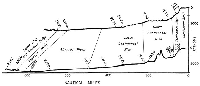
Figure 19.—Continental-margin provinces: Type profiles off Northwest Africa
Profiles E-19, E-20, and E-21 cross the continental margin off Dakar and the Cape Verde Plateau which rises from the lower continental rise. The Cape Verde Plateau consists largely of the coalescing bases of the volcanic Cape Verde Islands. The lower continental rise and the abyssal plain reach their maximum width at this latitude. The width of the ocean, the width of the Mid-Atlantic Ridge, the width of the abyssal hills, and the depth at the axis of maximum depth all reach their maximum values for the North Atlantic at this point. The characteristics of the continental rise in this sector are listed in Table 2. The reliability of these figures is much poorer than those given for northeastern United States, owing to the smaller number of profiles in this sector.
Table 2.
—
General characteristics of the continental rise northwest Africa Sector
Values measured from Profiles E-11 to E-21
Depth
Segment Upper edge Lower edge Gradient Width
Upper continental rise
1 1200 ± 200 1500 ± 200 1:90 ± 30 30 ± 10?
2 1500 ± 200 1600 ± 200 1:200 ± 100 30 ± 15?
3 1600 ± 200 1800 ± 100 1:100 ± 50 25 ± 15?
Lower continental rise
1 1800 ± 100 2000 ± 100 1:400 ± 200 75 ± 50
2 2000 ± 100 2000 ± 100 1:1500 ± 500 150 ± 50
3 2000 ± 100 2700 ± 100 1:500 ± 200 200 ± 50
Abyssal plain 2700 ± 100 3000 ± 75 1:1250 ± 250 200 ± 50
A famous submarine canyon, the Fosse de Cayar, lies just north of Cape Verde. Other submarine canyons are certainly present in the sector since any profile parallel to the strike of the topography reveals large irregularities probably related to canyons. Echograms (Pls. 9, 13) taken in the continental rise in this sector show distinct contrasts in the topographic detail of the sea floor. The rugged topography of the abyssal hills (Pl. 9, fig. 4) contrasts sharply with the nearly flat, extremely smooth abyssal plain. (Pl. 9, fig. 3). The continental rise is nowhere so smooth nor so flat as the abyssal plain. The continental rise ranges from 10- to 20-fathom rolling hills 5-10 miles in width to 2- to 5-fathom hills a few hundred feet across (Fig. 19). At the seaward edge of the abyssal plain the echo sounder penetrates the bottom to reveal interfaces 5-20 fathoms below (Pl. 13, Fig. 4). Sub-bottom penetration of 5-15 fathoms is occasionally encountered on the continental rise on local topographic highs. Lower continental-rise hills of the type observed off eastern United States have not been observed off Africa.
BENCHES AND TERRACES OF THE CONTINENTAL MARGIN
The topography of the continental margin provinces is divided into a series of benches or terraces. The largest are the continental shelf and slope (continental terrace) and the upper and lower continental rise. Superimposed on each of these major features is a series of smaller benches and terraces which range from features a few miles wide to simple breaks in the gradient of the continental slope.
Many of these features can be traced for hundreds of miles (Heezen et al., in press); some are intermittent, others change in depth with distance along the shelf; still others are only locally developed. We can propose at least four possible origins for terraces or benches: (1) ancient shore features; (2) structural (or rock) benching; (3) block faulting; and (4) landslide or slump scars.
The submerged terraces within a few hundred feet below present sea level can probably best be explained as ancient beaches formed during the lower sea levels of the Pleistocene. The fact that the same levels are found along coasts of diverse geology and tectonic development supports the eustatic origin of terraces between sea level and 70-100 fathoms. The gradients of the continental shelf are so low and the benches are so persistent that block faulting and slump scars are excluded as general explanations. The benches of the continental slope extend to depths of 1500 fathoms and vary in depth from point to point along the continental slope. These cannot be Pleistocene eustatic levels unless we consider that they were formed prior to recent large crustal deformations. Again the persistence of the benches for many miles argues against a fault-scarp or slump-scar hypothesis. Thus, while the benches of the continental shelf are probably ancient beaches, particularly those traced at the same depth for thousands of miles, the benches of the continental slope are probably rock benches, while some may represent step faulting.
SUBMERGED BEACHES ON THE CONTINENTAL SHELF: In Table 3 the depths of terraces or persistent levels of the continental shelf are listed for selected points in the North Atlantic. There is a remarkable uniformity in these data; the same levels are found near Newfoundland, in Florida, and on oceanic islands far from the glaciated areas.
On the basis of data obtained in the North Atlantic it is not possible to date the different terraces, but probably most were formed in the period between 12,000 and 5,000 years B.P. when the sea rose in consequence of the melting of the Wisconsin glaciers. Coring and dredging on these submerged ancient beaches could probably produce material datable by the radiocarbon method.
TABLE 3.
—
Depth (in fathoms) of prominent continental-shelf terraces
Each column based on only one nonprecision echogram
Placentia Bay, Nfd. St. John's, Nfd. Norfolk, Va. Charleston, S. C. Bimini, B.W.I. Miami, Fla. Barbados, B.W.I. St. Vincent, C.V.I. Dakar North Dakar South
10 12 10 8 10 8 10
15 15 15
20 18 20 20 18 20 20
25 24
30 30 28 30 28 28
35 38 35 35 32
40 38 38 38
42 45 42 45 42 45
50 50
55 55 58 56 54 55 55
68 65 68 65 60
72 76 72
80 80 80 80 85 81 80 78
Continental Margin Benches: On each profile across the continental margin is a series of benches and changes in gradient which range from the shelf break to slight changes in gradient on the continental slope.
If a field geologist enters a new area of sedimentary rocks where road cuts do not exist he invariably goes to the stream valleys, and here he gets his first and best view of the geologic section. The stream's gradient is adjusted to the resistance of the rocks over which it cuts, and the form of the valley-side slopes reveals the nature of the underlying rocks even if they are grassed over.
This obvious field method had never been fully applied to the continental margin. Stetson (1936) dredged in the canyons of Georges Bank, and his hauls included Cretaceous sandstones and Tertiary marls and green sands. He concluded that the canyons had been cut deep into the continental margin to expose the underlying Cretaceous rocks, but he considered the continental slope the product of depositional processes.
However Upham (1894) had suggested that the continental slope formed a continuous outcrop of Tertiary and Cretaceous sediments from Newfoundland to Florida, a suggestion the writers consider quite probable. That is to say, an analogy can be made between the continental slope and one face of the Grand Canyon or to an erosional escarpment bounding a high mesa or plateau like the Book Cliffs of Utah and Colorado.
Only a few areas of the world are sufficiently well sounded to provide data for a study of structural benches. One cannot expect to see identical structural benches in each profile even across a slope composed of a laterally uniform series of horizontal beds of contrasting lithologies. The exact mode of erosion, the local system of jointing, and chance variations in a number of other variables make it necessary to have a large number of closely spaced, accurately located profiles. We are fortunate that the Coast and Geodetic Survey has surveyed virtually the entire continental slope from Georges Bank to Norfolk, Virginia. Almost all these sounding lines are run at right angles to the strike of the topography and are thus suitable for analysis of structural benches. In this same area the dredgings of Stetson (1936) on Georges Bank and the Esso Hatteras Light test provide us with information on the stratigraphy of the sediments which form the continental shelf and slope. The seismic work of Ewing and collaborators (1937 et seq.) provides us with further information on the dips and on the depths of a number of sedimentary rock series of contrasting lithology.
Fishermen began finding fossiliferous rocks on Georges Bank well over a century ago. They were not particularly pleased to obtain rocks instead of fish and generally threw the accursed rocks back into the sea. Some curious fishermen brought a few of the rocks to shore, however, and in time some of these were received by the museums (Upham, 1894; Dahl, 1925). These rocks contain Tertiary and Cretaceous fossils. The depths and positions of recovery of the rocks were generally unknown to the museums, and no clear idea could be gained of the exact occurrence of this material. Stetson (1936; 1949) conducted a series of scientific dredging operations in the Georges Bank area. His aim was to recover more of these older rocks from known depth ranges and positions.
He concluded that the older rocks outcrop only in the submarine canyons. He found no consistent depth ranges for the series of Miocene and Upper Cretaceous rocks obtained.
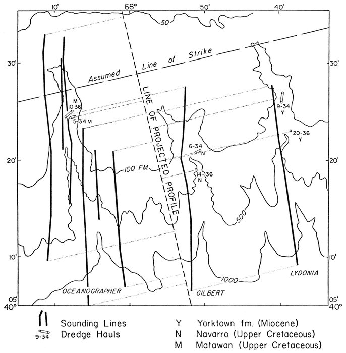
Figure 20.—Georges Bank canyons
Chart shows position of sounding lines and dredge hauls used to construct projected profile and inferred geologic section shown in Figure 21 (a). Sounding lines from Coast and Geodetic Survey Chart 1313.
In the Georges Bank area a series of prominent benches continues along the continental slope. If these are structural benches we should be able to trace them up the canyons and thus determine the dip of the formations. If the benches are the result of step faulting or landslide scars they would not extend up the canyons. In order to test these alternatives, a series of profiles has been plotted from the surveys of the Coast and Geodetic Survey. A line was drawn which paralleled most of the contours of the continental slope for 20 miles or more (Fig. 20). A second line was drawn at right angles to this first strike line. All sounding lines in the area were projected to this second dip line along lines parallel to the strike line, and plotted as a composite projected profile (Fig. 21). If the first line was essentially the strike of rock layers then we should be able to determine the dip of the beds by picking the successive benches as they occur on successive profiles across the canyon. In Figure 21 the results of the analysis of Oceanographer and Hydrographer canyons are presented. The dredge hauls by Stetson (1949) have also been projected on this profile. We see that a major bench occurs at A which passes below the hauls in which fossiliferous Navarro (Upper Cretaceous) was obtained and through the upper limit of the hauls where Matawan (Upper Cretaceous) was obtained. Thus if this horizon or one closely parallel to it is the Navarro-Matawan contract, the apparent discrepancies of the depth ranges of Stetson's dredge hauls are explained. Much more important to the present study is the dating of a prominent structural bench.
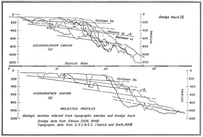
Figure 21.—Two projected profiles of Georges Bank canyons
Location of soundings for profile (a) shown in Figure 20. Soundings projected along strike to construct profile. Soundings for both profiles taken from Coast and Geodetic Survey Chart 1313.
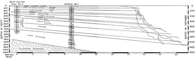
Figure 22.—Geologic section at Cape Hatteras, Virginia
Well logs from Swain (1947) and Spangler (1950). Four sounding profiles made by R. V. Atlantis are projected to profile. Note that resistant formations form prominent structural benches on continental slope.
The Esso Hatteras Light No. 1 test encountered crystalline rock at 1640 fathoms depth, beneath Lower Cretaceous strata (Spangler, 1950). The several holes drilled in the vicinity revealed remarkably constant dips over a wide area. This is in fact true of the whole coastal plain. Since the Hatteras well is only 17 miles from the continental slope, it seems reasonable to project the dips to the continental slope. We can then observe whether prominent benches on the continental slope correlate with resistant strata in the well. We find (Fig. 22) that they do. In the area between Cape Hatteras and Nova Scotia several cores have revealed reworked Eocene, Miocene, and Cretaceous Foraminifera. In 1947 Northrop and Heezen (1951) obtained a photograph and a core at 500 fathoms on the continental slope. The core contained Eocene (Jackson) sediments, and the photograph showed a rock ledge below the marl sampled. Although sediment cores, particularly those of reworked material, do not provide as reliable information as dredge hauls, this outcrop of un-reworked Eocene may also be used in dating the structural benches of the continental slope.
The structural benches between Cape Hatteras and Cape May are remarkably uniform and persistent (Fig. 23). On the basis of the extrapolation shown in Figure 22, the structural benches in this area have been correlated with the formations encountered in the Hatteras well. North of Cape May a major angular unconformity separates the late Tertiary and Cretaceous formations. Eocene has not been found north of Nantucket. Upper Cretaceous has been found at about 400 fathoms off Georges Bank (Fig. 21), and Lower Cretaceous has been dredged at 200 fathoms off Banquereau Bank, Nova Scotia.
Between 1945 and 1950 workers on the Atlantis made several sounding profiles east of Georgia, North Carolina, and South Carolina. Each crossed the precipitous Blake Escarpment. It was quite clear that no sediment could be accumulating on such a steep escarpment and that beds of ancient sediments and perhaps crystalline rocks must outcrop on the escarpment. In 1949 and 1950 a few cores were taken on the escarpment which encountered Miocene and Eocene sediments in depths of 500-800 fathoms (Ericson, Ewing, and Heezen, 1952). The marked similarity of all topographic profiles further supported the view that the escarpment was formed by the outcrop of an orderly sequence of horizontal sedimentary rock layers. With this specific problem in mind a cruise was made to the Blake-Bahama area on the research vessel Atlantis, in 1951. More than 50 cores were obtained. Sediments of Recent to Upper Cretaceous age were obtained on the Blake Escarpment and from the steep walls of the Bahama Channels (Ericson, Ewing, and Heezen, 1952). Seismic-refraction work by Katz and Ewing (1955) and Nafe et al. (unpublished) and reflection work by Ewing and Landisman (unpublished) have revealed that distinct seismic interfaces can be traced into the structural benches on the Blake Escarpment. The ancient sediments from the Blake Escarpment and the log of the Andros well allow the dating of some of these formation contacts. At present the most prominent bench at 1200-1500 fathoms appears to mark the base of the Upper Cretaceous. Dredging and further coring on the Blake Escarpment below 1400 fathoms is one of the most promising projects of its type despite the great difficulties involved.
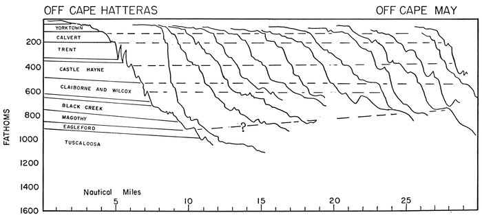
Figure 23.—Correlation of structural benches off northeast United States
Soundings by Coast and Geodetic Survey; 35° 30´N.-38° 30´N.
Lee (1951), who made a topographic study of Exuma Sound, Bahamas, traced several prominent benches through 51 cross sections of the sound.
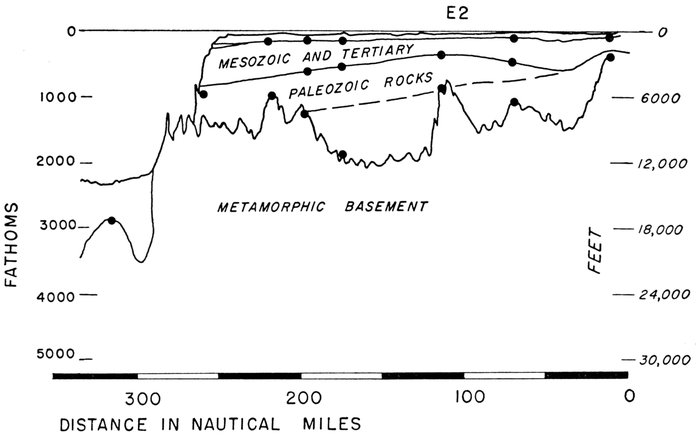
Figure 24.—Geologic section: Western Europe based on refraction measurements
Data from Day et al. (1956) and Hill (1957). Geologic ages are those assigned by Day on the basis of velocity; they are not based on dredging or drilling.
Seismic-refraction profiles have been made across the continental slope southwest from the English Channel. These studies were initiated by Bullard and Gaskell (1941) and have been most recently reported on by Day et al. (1956). The seismic section of Day et al. (1956) (Fig. 24) suggests that the prominent bench at 1600 fathoms and the short but steep scarp just below represent the outcrop of the metamorphic basement on the continental slope. It is postulated that the prominent bench at 900 fathoms may represent the base of the Mesozoic, and the smaller bench at 300 fathoms the base of the Miocene. Tertiary sediments have been obtained from the walls of canyons in the Bay of Biscay in depths down to about 1500 fathoms (Bourcart and Marie, 1951). The age assignments in Figure 24 are taken directly from Day et al. (1956) and have not been confirmed by dredging on the continental slope.
The writers conclude that the majority of the topographic benches of the continental slope and other category II provinces are structural benches which reflect the outcrop of resistant rock layers. This of course implies that the continental slope is not a simple depositional feature but a structural or erosional one. Since the structural benches are present both in the canyons and on the un-dissected slope, the occurrence of Tertiary and Cretaceous rocks on the continental slope cannot be explained by erosion of submarine canyons into an otherwise depositional terrace in the manner implied by Stetson (1949).
The existence of such persistent benches implies that the entire width of the category II provinces must be at most only thinly covered by recent sediments. Since the discovery of the great importance of turbidity currents and the relatively low slopes necessary for their occurrence, it has been a great puzzle to the writers how sediments could be permanently deposited on the present continental slope. The answer is simply that they are not. In addition to the turbidity currents which provide a mechanism for the seaward transport of sediment down the continental margin, deep-ocean currents probably sort and transport much sediment along a course parallel to the continental slope. It has recently been demonstrated (Swallow and Worthington, 1957) that velocities of 10-20 cm/sec are attained by ocean currents which flow parallel to the continental slope. The particular measurement referred to was made at 1600 fathoms on the continental slope south of Cape Hatteras where a 17 cm/sec southward-moving current was observed. The strong current is not a local phenomenon since it was found in the South Atlantic by Wüst (1935) and is predicted by theories of ocean circulation (Stommel, 1957). Photographs of ripple marks on the continental slope (See for instance Fig. 13 in Elmendorf and Heezen, 1957) had indicated high velocities, but it was not possible to distinguish between a current and an oscillatory origin. The total effect of slides, slumps, turbidity currents, and strong ocean-bottom currents is the removal of most of the unconsolidated Recent sediments from the continental slope.
The deposition of a series of Mesozoic and Tertiary sediments on the subsiding margin of the continental block has produced a wedge of sedimentary rock largely of shallow marine facies. Each successive strata laid down on the shelf was abruptly terminated at the shelf break by the processes of erosion which continuously or periodically clear the unconsolidated sediment from the continental slope. Deposition on the shelf was interrupted by several marine regressions which produced unconformities in the stratigraphic sequence. Nafe and Drake (1957) observed that the increase of seismic velocity with depth and therefore the increase in compaction with depth is more rapid on the continental shelf than in the deep sea. This is probably in part the result of erosion of previously deposited sediments and sedimentary rocks along the unconformities and in part the result of ground-water cementation during periods of emergence.
Each unconformity should mark a lithologic change and consequently a change in the resistance to erosion of the rock series. Many structural benches may indicate surfaces of unconformity. The most recent unconformity in the sequence lies between the surface of the emerged Wisconsin continental shelf and the overlying post-glacial shelf sediments.
The shelf break is defined as the most prominent break in slope between the continental shelf and continental slope. The most prominent break may locally be a Pliocene or Miocene structural bench, but elsewhere late Pleistocene or Recent strata may form the shelf break. Rates of subsidence, erosion, and sediment supply vary from place to place along the continental shelf, and the lack of conformity either in depth or in age of the shelf break is thus easily explained.
The deeper structure of the continental margin indicates a fundamental structural discontinuity at the base of the continental slope (category II provinces). It would seem a small extrapolation to attribute a fault origin to the continental slope. Although faulting may have played a large part in the earliest history of the category II provinces, alternate periods of sedimentation and marine planation on the continental shelf and long-continued erosion by slumps, turbidity currents, and deep-sea currents on the continental slope, together with a general subsidence of the area, could have alone produced the characteristic form of the continental terrace.
Further work on structural benches co-ordinated with a study of ancient sediments from dredges and cores should enable us to draw a geologic map of the continental slope of eastern United States and Europe (Heezen et al., in preparation).
GEOLOGY AND GEOPHYSICS OF CONTINENTAL MARGIN PHYSIOGRAPHIC PROVINCES
Seismicity of the continental-margin provinces.—Plate 29 shows the distribution of epicenters in the North Atlantic. Except in the Puerto Rico Trench and the adjacent Antilles Arc, earthquakes are exceedingly rare in the continental-margin provinces of the North Atlantic. From the Bahamas through the Grand Banks the only earthquakes reported since 1910 are two near the Laurentian Channel. In the eastern Atlantic an earthquake belt crosses the continental margin near Gibraltar but does not seem to be directly associated with the Atlantic continental margins. If the continental slope in the area covered by Plate 29 is a fault scarp, we must infer that the motion has now been arrested.
Magnetic anomalies and continental-margin provinces.—The first continuously recorded total-intensity magnetic data for the Atlantic were obtained in 1946 on a flight from Long Island, New York, to Bermuda, and return (Keller et al., 1954). The first data from a ship-towed magnetometer were obtained in 1948 (Heezen, Ewing, and Miller, 1953).
The initial measurements showed (1) several large (> 300γ) anomalies on the continental shelf, (2) a large (> 500γ) anomaly over the continental slope, (3) an exceptionally smooth field over the category III provinces, (4) rough fields with 5- to 15-mile wide 100 to 200γ anomalies over oceanic ridges and rises, (5) enormous anomalies (> 1000γ) over seamounts and islands, and (6) large anomalies (> 500γ) over the crest of the Mid-Atlantic Ridge.
The large anomalies on the continental shelf were considered to indicate large volcanic cones buried by the sediments of the continental shelf (Miller and Ewing, 1956). The anomaly over the continental slope was considered to be the magnetic-edge effect associated with the abrupt edge of the continental block. The rough fields over the oceanic rises and ridges were attributed to variations in the susceptibility of the crustal rocks, probably related to volcanic extrusions and intrusions. The anomaly over the crest of the Mid-Atlantic Ridge was not recognized as a general pattern until later when many measurements were made. The major puzzle for which no explanation was readily obtained was the origin of the smooth field over the continental rise. The smooth or quiet field has been observed on each crossing of the category III provinces, and even such a sharp-sided feature as the Puerto Rico Trench failed to show a magnetic anomaly (Davidson and Miller, 1956). We can thus state that all category III provinces are characterized by a smooth magnetic field.
The significance of this point is not yet clear, but it must be of major importance to the full understanding of the continental margin.
Crustal structure and continental-margin provinces.—Maurice Ewing and his associates have made more than 1000 seismic-refraction measurements to determine the crustal structure of continental margins. Most of the published results pertain to the eastern continental margin of the United States (Drake et al., in press), but much material will soon be published on the continental margin of Sahara, Sierra Leone, Brazil, Argentina, Guiana, Spain, Morocco, the Gulf of Mexico, and the Caribbean Sea. In addition extensive work has been accomplished by Bullard, Gaskell, and Hill in the western approaches to the English Channel. In some areas seismic, gravity, and magnetic measurements were made along the same lines and have been subjected to an integrated analysis (Worzel and Shurbet, 1955c).
In Plate 26 four profiles replotted from published sections are shown. Each profile is plotted at 40:1 exaggeration, and depths are indicated in fathoms and kilometers to facilitate comparison with the profiles and topographic descriptions given elsewhere in this paper. Some stations which lie up to 100 miles from a profile have been projected along the strike of the topography. In general each profile indicates (1) a thick lens of sediment and sedimentary rock beneath the continental rise; (2) a major discontinuity in crustal structure at the base of the continental slope; and (3) a wedge of low-velocity sedimentary rocks ("unconsolidated") overlying a lens of higher-velocity ("semi-consolidated and consolidated") sedimentary rocks beneath the continental shelf. The basin, filled with higher-velocity sedimentary rocks, is formed by an upturned lip of crystalline basement rocks near the continental slope. Local variations in thickness and velocity give rise to interesting minor configurations, but the basic structure is nearly identical in all the sections. The main contrast is that the category III provinces are underlain by thick sedimentary rocks in the case of the continental rise, and successively thinner accumulations of sedimentary rock are associated with the marginal basins and marginal trenches.
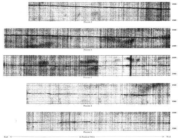
PDR record of Biscay Abyssal Plain
Note several small depressions, each a few fathoms deep. Figures 1-5 form a continuous profile. Depth in fathoms.
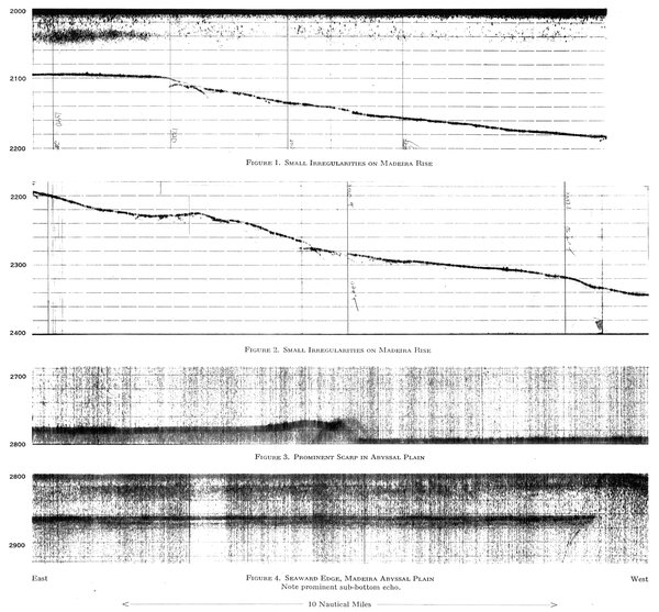
PDR records of Madeira Abyssal Plain and the Madeira Rise
Depth in fathoms.
Since the main difference in the continental-margin sections seems to be a greatly enhanced continental-rise sedimentary section to the north as compared with the Blake Plateau—Bahama—Puerto Rico region, it seems reasonable to conclude that the main difference in the topography is the result of different sedimentation rates or a different time of origin, rather than of a vastly different structural origin. The sedimentary rock column beneath the continental rise is truly geosynclinal in thickness. Whether this great lens of sediment and sedimentary rock will eventually be deformed into a mountain range to form a new addition to the continent as advocated by the accretion school or whether it will lie forever on the sea floor is one of the great speculations of geology.
Sediment distribution and physiographic provinces of the continental margin. The recent sediments of the category I provinces are largely sands, silts, silty lutites, and carbonates (Stetson, 1938; Shepard and Cohee, 1936; Newell, 1955). All these sediments can be assigned to the orthoquartzite suite of Pettijohn (1957). Judging from the ancient sediments dredged from the continental slope and obtained by drilling, the category I provinces have been receiving orthoquartzite sediments at least since the Cretaceous. In category II provinces Recent sediments are either lacking or are very thin. Those Recent sediments which temporarily remain in the province range from foraminiferal lutites, found in such areas as the Bahamas, to silty lutites relatively poor in pelagic fossils, found in the higher latitudes. In general category II provinces are characterized by nondeposition or erosion.
The sediments of the category III provinces include both pelagic and clastic terrigenous sediments. The outer ridge is covered by Globigerina ooze in depths shallower than about 2200 fathoms and by red clay in deeper areas. The continental rise is generally covered by silty foraminiferal lutites, but, where submarine canyon deltas spread out from the mouths of submarine canyons (Ericson et al., 1951, 1952), beds of graded sand and silts from a few centimeters to a few meters in thickness are interbedded with lutites. In the marginal trenches and marginal basins graded calcareous sands alternate with low-carbonate lutites. The category III provinces of northwest Africa are dominated by two groups of volcanic islands and seamounts which contribute flows and volcanic detritus to the continental-rise sediments. In general the category III provinces are dominated by sediments ascribable to the graywacke suite of Pettijohn (1957).
Past, present, and future of continental-margin physiographic provinces.—It takes only a little imagination to see a historical or genetic sequence in the four profiles of Plate 26. The Puerto Rico Trench—outer-ridge profiles thus may represent a continental margin in youth, the Blake—Bahama—outer-ridge profile a margin in late youth or early maturity, and Newfoundland and northeast United States profiles a margin in late maturity or old age.
The lens of sediments that has filled the marginal trench off northeastern United States is truly geosynclinal in thickness (Drake et al., in press). The sediments of the shelf lens are similar in lithology to the orthoquartzite suite of a mio-geosyncline (cf. Kay, 1951), and the thicker continental-rise lens is probably similar in lithology to the graywacke-volcanic suite of a eugeosyncline. (Kay, 1951). It seems virtually certain that ancient orthogeosynclines were, before deformation, closely analogous to the continental margins. The major problem is completing the sequence from filled geosyncline to folded mountains is the mechanism by which the earth's crust beneath the geosyncline thickens by 20-30 km. Although we cannot predict the future of the present continental margin with any assurance until the mechanism of thickening is understood, it seems probable that before deformation the older orthogeosynclines were similar in most details to the modern continental margins.
It seems possible that the present continental margins will in some future geological period be uplifted into folded mountains.