Front matter (continued 5)
Reading edition · Edition 2
Minor causes of earthquakes. Since any concussion within the crust sets up an earth jar, there are several minor causes of earthquakes, such as volcanic explosions and even the collapse of the roofs of caves. The earthquakes which attend the eruption of volcanoes are local, even in the case of the most violent volcanic paroxysms known. When the top of a volcano has been blown to fragments, the accompanying earth shock has sometimes not been felt more than twenty-five miles away.
Depth of focus. The focus of the Charleston earthquake, estimated at about twelve miles below the surface, was exceptionally deep. Volcanic earthquakes are particularly shallow, and probably no earthquakes known have started at a greater depth than fifteen or twenty miles. This distance is so slight compared with the earth’s radius that we may say that earthquakes are but skin-deep.
Should you expect the velocity of an earthquake to be greater in a peneplain or in a river delta?
After an earthquake, piles on which buildings rested were found driven into the ground, and chimneys crushed at base. From what direction did the shock come?
Chimneys standing on the south walls of houses toppled over on the roof. Should you infer that the shock in this case came from the north or south?
How should you expect a shock from the east to affect pictures hanging on the east and the west walls of a room? how the pictures hanging on the north and the south walls?
In parts of the country, as in southwestern Wisconsin, slender erosion pillars, or “monuments,” are common. What inference could you draw as to the occurrence in such regions of severe earthquakes in the recent past?
CHAPTER XI
VOLCANOES
Connected with movements of the earth’s crust which take place so slowly that they can be inferred only from their effects is one of the most rapid and impressive of all geological processes,—the extrusion of molten rock from beneath the surface of the earth, giving rise to all the various phenomena of volcanoes.
In a volcano, molten rock from a region deep below, which we may call its reservoir, ascends through a pipe or fissure to the surface. The materials erupted may be spread over vast areas, or, as is commonly the case, may accumulate about the opening, forming a conical pile known as the volcanic cone. It is to this cone that popular usage refers the word volcano; but the cone is simply a conspicuous part of the volcanic mechanism whose still more important parts, the reservoir and the pipe, are hidden from view.
Volcanic eruptions are of two types,—effusive eruptions, in which molten rock wells up from below and flows forth in streams of lava (a comprehensive term applied to all kinds of rock emitted from volcanoes in a molten state), and explosive eruptions, in which the rock is blown out in fragments great and small by the expansive force of steam.
Eruptions of the Effusive Type
The Hawaiian volcanoes. The Hawaiian Islands are all volcanic in origin, and have a linear arrangement characteristic of many volcanic groups in all parts of the world. They are strung along a northwest-southeast line, their volcanoes standing in two parallel rows as if reared along two adjacent lines of fracture or folding. In the northwestern islands the volcanoes have long been extinct and are worn low by erosion. In the southeastern island, Hawaii, three volcanoes are still active and in process of building. Of these Mauna Loa, the monarch of volcanoes, with a girth of two hundred miles and a height of nearly fourteen thousand feet above sea level, is a lava dome the slope of whose sides does not average more than five degrees. On the summit is an elliptical basin ten miles in circumference and several hundred feet deep. Concentric cracks surround the rim, and from time to time the basin is enlarged as great slices are detached from the vertical walls and engulfed. Such a volcanic basin, formed by the insinking of the top of the cone, is called a caldera.
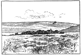
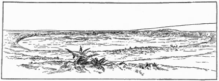
Fig. 211. Mauna Loa Fig. 212. Caldera of Kilauea
On the flanks of Mauna Loa, four thousand feet above sea level, lies the caldera of Kilauea, an independent volcano whose dome has been joined to the larger mountain by the gradual growth of the two. In each caldera the floor, which to the eye is a plain of black lava, is the congealed surface of a column of molten rock. At times of an eruption lakes of boiling lava appear which may be compared to air holes in a frozen river. Great waves surge up, lifting tons of the fiery liquid a score of feet in air, to fall back with a mighty plunge and roar, and occasionally the lava rises several hundred feet in fountains of dazzling brightness. The lava lakes may flood the floor of the basin, but in historic times have never been known to fill it and overflow the rim. Instead, the heavy column of lava breaks way through the sides of the mountain and discharges in streams which flow down the mountain slopes for a distance sometimes of as much as thirty-five miles. With the drawing off of the lava the column in the duct of the volcano lowers, and the floor of the caldera wholly or in part subsides. A black and steaming abyss marks the place of the lava lakes (Fig. 213). After a time the lava rises in the duct, the floor is floated higher, and the boiling lakes reappear.
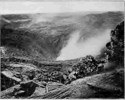
Fig. 213. A Portion of the Caldera of Kilauea after a Collapse following an Eruption
The eruptions of the Hawaiian volcanoes are thus of the effusive type. The column of lava rises, breaks through the side of the mountain, and discharges in lava streams. There are no explosions, and usually no earthquakes, or very slight ones, accompany the eruptions. The lava in the calderas boils because of escaping steam, but the vapor emitted is comparatively little, and seldom hangs above the summits in heavy clouds. We see here in its simplest form the most impressive and important fact in all volcanic action, molten rock has been driven upward to the surface from some deep-lying source.
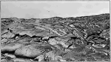
Fig. 214. Pahoehoe Lava, Hawaii
Lava flows. As lava issues from the side of a volcano or overflows from the summit, it flows away in a glowing stream resembling molten iron drawn white-hot from an iron furnace. The surface of the stream soon cools and blackens, and the hard crust of nonconducting rock may grow thick and firm enough to form a tunnel, within which the fluid lava may flow far before it loses its heat to any marked degree. Such tunnels may at last be left as caves by the draining away of the lava, and are sometimes several miles in length.
Pahoehoe and aa. When the crust of highly fluid lava remains unbroken after its first freezing, it presents a smooth, hummocky, and ropy surface known by the Hawaiian term pahoehoe (Fig. 214). On the other hand, the crust of a viscid flow may be broken and splintered as it is dragged along by the slowly moving mass beneath. The stream then appears as a field of stones clanking and grinding on, with here and there from some chink a dull red glow or a wisp of steam. It sets to a surface called aa, of broken, sharp-edged blocks, which is often both difficult and dangerous to traverse (Fig. 215).
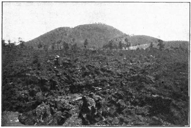
Fig. 215. Lava Flow of the Aa Type; Cinder Cones in the Distance, Arizona
Fissure eruptions. Some of the largest and most important outflows of lava have not been connected with volcanic cones, but have been discharged from fissures, flooding the country far and wide with molten rock. Sheet after sheet of molten rock has been successively outpoured, and there have been built up, layer upon layer, plateaus of lava thousands of feet in thickness and many thousands of square miles in area.
Iceland. This island plateau has been rent from time to time by fissures from which floods of lava have outpoured. In some instances the lava discharges along the whole length of the fissure, but more often only at certain points upon it. The Laki fissure, twenty miles long, was in eruption in 1783 for seven months. The inundation of fluid rock which poured from it is the largest of historic record, reaching a distance of forty-seven miles and covering two hundred and twenty square miles to an average depth of a hundred feet. At the present time the fissure is traced by a line of several hundred insignificant mounds of fragmental materials which mark where the lava issued (Fig. 216).
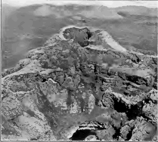
Fig. 216. Small Cinder Cones marking an Eruptive Fissure, Iceland
The distance to which the fissure eruptions of Iceland flow on slopes extremely gentle is noteworthy. One such stream is ninety miles in length, and another seventy miles long has a slope of little more than one half a degree.
Where lava is emitted at one point and flows to a less distance there is gradually built up a dome of the shape of an inverted saucer with an immense base but comparatively low. Many lava domes have been discovered in Iceland, although from their exceedingly gentle slopes, often but two or three degrees, they long escaped the notice of explorers.
The entire plateau of Iceland, a region as large as Ohio, is composed of volcanic products,—for the most part of successive sheets of lava whose total thickness falls little short of two miles. The lava sheets exposed to view were outpoured in open air and not beneath the sea; for peat bogs and old forest grounds are interbedded with them, and the fossil plants of these vegetable deposits prove that the plateau has long been building and is very ancient. On the steep sea cliffs of the island, where its structure is exhibited, the sheets of lava are seen to be cut with many dikes,—fissures which have been filled by molten rock,—and there is little doubt that it was through these fissures that the lava outwelled in successive flows which spread far and wide over the country and gradually reared the enormous pile of the plateau.
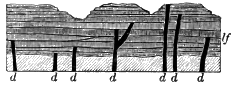
Fig. 217. Diagram illustrating the Structure of a Lava Plateau such as Iceland lf, lava flows; d, dikes
Eruptions of the Explosive Type
In the majority of volcanoes the lava which rises in the pipe is at least in part blown into fragments with violent explosions and shot into the air together with vast quantities of water vapor and various gases. The finer particles into—which the lava is exploded are called volcanic dust or volcanic ashes, and are often carried long distances by the wind before they settle to the earth. The coarser fragments fall about the vent and there accumulate in a steep, conical, volcanic mountain. As successive explosions keep open the throat of the pipe, there remains on the summit a cup-shaped depression called the crater.
Stromboli. To study the nature of these explosions we may visit Stromboli, a low volcano built chiefly of fragmental materials, which rises from the sea off the north coast of Sicily and is in constant though moderate action.
Over the summit hangs a cloud of vapor which strikingly resembles the column of smoke puffed from the smokestack of a locomotive, in that it consists of globular masses, each the product of a distinct explosion. At night the cloud of vapor is lighted with a red glow at intervals of a few minutes, like the glow on the trail of smoke behind the locomotive when from time to time the fire box is opened. Because of this intermittent light flashing thousands of feet above the sea, Stromboli has been given the name of the Lighthouse of the Mediterranean.
Looking down into the crater of the volcano, one sees a viscid lava slowly seething. The agitation gradually increases. A great bubble forms. It bursts with an explosion which causes the walls of the crater to quiver with a miniature earthquake, and an outrush of steam carries the fragments of the bubble aloft for a thousand feet to fall into the crater or on the mountain side about it. With the explosion the cooled and darkened crust of the lava is removed, and the light of the incandescent liquid beneath is reflected from the cloud of vapor which overhangs the cone.
At Stromboli we learn the lesson that the explosive force in volcanoes is that of steam. The lava in the pipe is permeated with it much as is a thick boiling porridge. The steam in boiling porridge is unable to escape freely and gathers into bubbles which in breaking spurt out drops of the pasty substance; in the same way the explosion of great bubbles of steam in the viscid lava shoots clots and fragments of it into the air.
Krakatoa. The most violent eruption of history, that of Krakatoa, a small volcanic island in the strait between Sumatra and Java, occurred in the last week of August, 1883. Continuous explosions shot a column of steam and ashes. seventeen miles in air. A black cloud, beneath which was midnight darkness and from which fell a rain of ashes and stones, overspread the surrounding region to a distance of one hundred and fifty miles. Launched on the currents of the upper air, the dust was swiftly carried westward to long distances. Three days after the eruption it fell on the deck of a ship sixteen hundred miles away, and in thirteen days the finest impalpable powder from the volcano had floated round the globe. For many months the dust hung over Europe and America as a faint lofty haze illuminated at sunrise and sunset with brilliant crimson. In countries nearer the eruption, as in India and Africa, the haze for some time was so thick that it colored sun and moon with blue, green, and copper-red tints and encircled them with coronas.
At a distance of even a thousand miles the detonations of the eruption sounded like the booming of heavy guns a few miles away. In one direction they were audible for a distance as great as that from San Francisco to Cleveland. The entire atmosphere was thrown into undulations under which all barometers rose and fell as the air waves thrice encircled the earth. The shock of the explosions raised sea waves which swept round the adjacent shores at a height of more than fifty feet, and which were perceptible halfway around the globe.
At the close of the eruption it was found that half the mountain had been blown away, and that where the central part of the island had been the sea was a thousand feet deep.
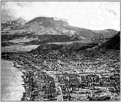
Fig. 218. Ruins of St. Pierre, Martinique; Mt. Pelée in the Distance
Martinique and St. Vincent. In 1902 two dormant volcanoes of the West Indies, Mt. Pelee in Martinique and Soufriére in St. Vincent, broke into eruption simultaneously. No lava was emitted, but there were blown into the air great quantities of ashes, which mantled the adjacent parts of the islands with a pall as of gray snow. In early stages of the eruption lakes which occupied old craters were discharged and swept down the ash-covered mountain valleys in torrents of boiling mud.
On several occasions there was shot from the crater of each volcano a thick and heavy cloud of incandescent ashes and steam, which rushed down the mountain side like an avalanche, red with glowing stones and scintillating with lightning flashes. Forests and buildings in its path were leveled as by a tornado, wood was charred and set on fire by the incandescent fragments, all vegetation was destroyed, and to breathe the steam and hot, suffocating dust of the cloud was death to every living creature. On the morning of the 8th of May, 1902, the first of these peculiar avalanches from Mt. Pelee fell on the city of St. Pierre and instantly destroyed the lives of its thirty thousand inhabitants.
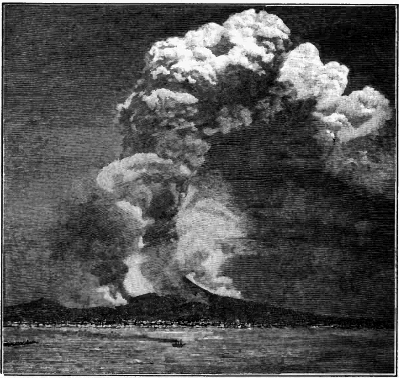
Fig. 219. An Eruption of Vesuvius, 1872
The huge column of dust and steam rises to a height of about four miles above the sea. Drifting down the wind, the vapor condenses into copious rains. Such often produce destructive torrents of mud as they sweep down the ash-covered mountain side, and during the historic eruption of Vesuvius in A.D. 69 the city of Herculaneum was thus buried. Lava flows are marked by the overhanging clouds of aqueous vapor condensed from the steam which the molten rock gives off.
The eruptions of many volcanoes partake of both the effusive and the explosive types: the molten rock in the pipe is in part blown into the air with explosions of steam, and in part is discharged in streams of lava over the lip of the crater and from fissures in the sides of the cone. Such are the eruptions of Vesuvius, one of which is illustrated in Figure 219.
Submarine eruptions. The many volcanic islands of the ocean and the coral islands resting on submerged volcanic peaks prove that eruptions have often taken place upon the ocean floor and have there built up enormous piles of volcanic fragments and lava. The Hawaiian volcanoes rise from a depth of eighteen thousand feet of water and lift their heads to about thirty thousand feet above the ocean bed. Christmas Island (see p. 194), built wholly beneath the ocean, is a coral-capped volcanic peak, whose total height, as measured from the bottom of the sea, is more than fifteen thousand feet. Deep-sea soundings have revealed the presence of numerous peaks which fail to reach sea level and which no doubt are submarine volcanoes. A number of volcanoes on the land were submarine in their early stages, as, for example, the vast pile of Etna, the celebrated Sicilian volcano, which rests on stratified volcanic fragments containing marine shells now uplifted from the sea.
Submarine outflows of lava and deposits of volcanic fragments become covered with sediments during the long intervals between eruptions. Such volcanic deposits are said to be contemporaneous, because they are formed during the same period as the strata among which they are imbedded. Contemporaneous lava sheets may be expected to bake the surface of the stratum on which they rest, while the sediments deposited upon them are unaltered by their heat. They are among the most permanent records of volcanic action, far outlasting the greatest volcanic mountains built in open air.
From upraised submarine volcanoes, such as Christmas Island, it is learned that lava flows which are poured out upon the bottom of the sea do not differ materially either in composition or texture from those of the land.
Volcanic Products
Vast amounts of steam are, as we have seen, emitted from volcanoes, and comparatively small quantities of other vapors, such as various acid and sulphurous gases. The rocks erupted from volcanoes differ widely in chemical composition and in texture.
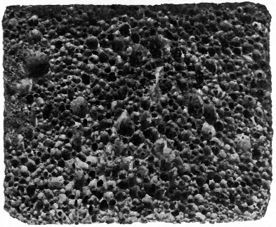
Fig. 220. Cellular Lava
Acidic and basic lavas. Two classes of volcanic rocks may be distinguished,—those containing a large proportion of silica (silicic acid, SiO2) and therefore called acidic, and those containing less silica and a larger proportion of the bases (lime, magnesia, soda, etc.) and therefore called basic. The acidic lavas, of which rhyolite and thrachyte are examples, are comparatively light in color and weight, and are difficult to melt. The basic lavas, of which basalt is a type, are dark and heavy and melt at a lower temperature.
Scoria and pumice. The texture of volcanic rocks depends in part on the degree to which they were distended by the steam which permeated them when in a molten state. They harden into compact rock where the steam cannot expand. Where the steam is released from pressure, as on the surface of a lava stream, it forms bubbles (steam blebs) of various sizes, which give the hardened rock a cellular structure (Fig. 220), In this way are formed the rough slags and clinkers called scoria, which are found on the surface of flows and which are also thrown out as clots of lava in explosive eruptions.
On the surface of the seething lava in the throat of the volcano there gathers a rock foam, which, when hurled into the air, is cooled and falls as pumice,—a spongy gray rock so light that it floats on water.
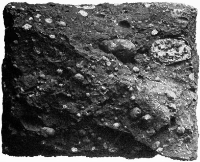
Fig. 221. Amygdules in Lava
Amygdules. The steam blebs of lava flows are often drawn out from a spherical to an elliptical form resembling that of an almond, and after the rock has cooled these cavities are gradually filled with minerals deposited from solution by underground water. From their shape such casts are called amygdules (Greek, amygdalon, an almond). Amygdules are commonly composed of silica. Lavas contain both silica and the alkalies, potash and soda, and after dissolving the alkalies, percolating water is able to take silica also into solution. Most agates are banded amygdules in which the silica has been laid in varicolored, concentric layers (Fig. 222).
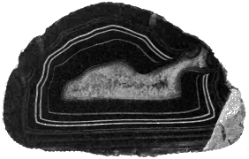
Fig. 222. Polished Section of an Agate
Glassy and stony lavas. Volcanic rocks differ in texture according also to the rate at which they have solidified. When rapidly cooled, as on the surface of a lava flow, molten rock chills to a glass, because the minerals of which it is composed have not had time to separate themselves from the fused mixture and form crystals. Under slow cooling, as in the interior of the flow, it becomes a stony mass composed of crystals set in a glassy paste. In thin slices of volcanic glass one may see under the microscope the beginnings of crystal growth in filaments and needles and feathery forms, which are the rudiments of the crystals of various minerals.
Spherulites, which also mark the first changes of glassy lavas toward a stony condition, are little balls within the rock, varying from microscopic size to several inches in diameter, and made up of radiating fibers.
Perlitic structure, common among glassy lavas, consists of microscopic curving and interlacing cracks, due to contraction.
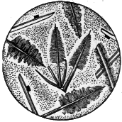
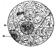
Fig. 223. Microsection showing the Beginnings of Crystal Growth in Glassy Lava Fig. 224. Perlitic Structure and Spherulites, a, a
Flow lines are exhibited by volcanic rocks both to the naked eye and under the microscope. Steam blebs, together with crystals and their embryonic forms, are left arranged in lines and streaks by the currents of the flowing lava as it stiffened into rock.
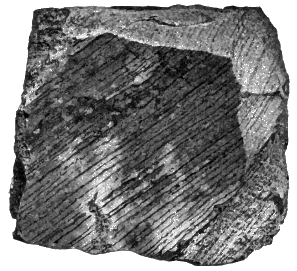
Fig. 225. Flow Lines in Lava
Porphyritic structure. Rocks whose ground mass has scattered through it large conspicuous crystals(Fig. 226) are said to be porphyritic, and it is especially among volcanic rocks that this structure occurs. The ground mass of porphyries either may be glassy or may consist in part of a felt of minute crystals; in either case it represents the consolidation of the rock after its outpouring upon the surface. On the other hand, the large crystals of porphyry have slowly formed deep below the ground at an earlier date.
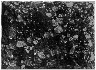
Fig. 226. Porphyritic Structure
Columnar structure. Just as wet starch contracts on drying to prismatic forms, so lava often contracts on cooling to a mass of close-set, prismatic, and commonly six-sided columns, which stand at right angles to the cooling surface. The upper portion of a flow, on rapid cooling from the surface exposed to the air, may contract to a confused mass of small and irregular prisms; while the remainder forms large and beautifully regular columns, which have grown upward by slow cooling from beneath (Fig. 227).
Fragmental Materials
Rocks weighing many tons are often thrown from a volcano at the beginning of an outburst by the breaking up of the solidified floor of the crater; and during the progress of an eruption large blocks may be torn from the throat of the volcano by the outrush of steam. But the most important fragmental materials are those derived from the lava itself. As lava rises in the pipe, the steam which permeates it is released from pressure and explodes, hurling the lava into the air in fragments of all sizes,—large pieces of scoria, lapilli (fragments the size of a pea or walnut), volcanic “sand” and volcanic “ashes.” The latter resemble in appearance the ashes of wood or coal, but they are not in any sense, like them, a residue after combustion.
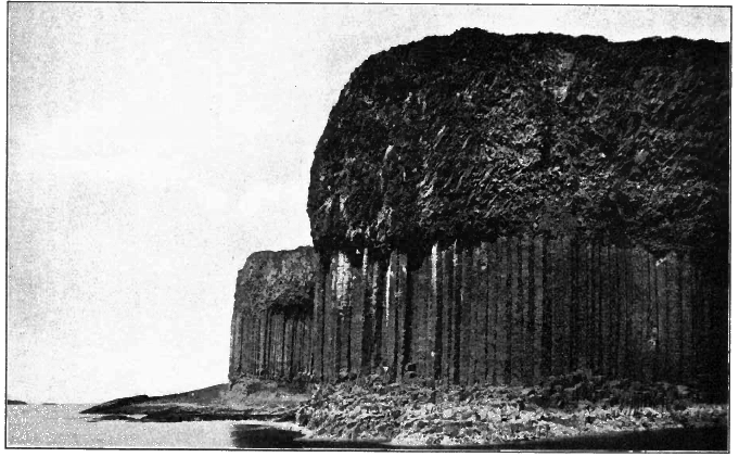
Fig. 227. Columnar Structure in Basaltic Lava, Scotland
Volcanic ashes are produced in several ways: lava rising in the volcanic duct is exploded into fine dust by the steam which permeates it; glassy lava, hurled into the air and cooled suddenly, is brought into a state of high strain and tension, and, like Prince Rupert’s drops, flies to pieces at the least provocation. The clash of rising and falling projectiles also produces some dust, a fair sample of which may be made by grating together two pieces of pumice.
Beds of volcanic ash occur widely among recent deposits in the western United States. In Nebraska ash beds are found in twenty counties, and are often as white as powdered pumice. The beds grow thicker and coarser toward the southwestern part of the state, where their thickness sometimes reaches fifty feet. In what direction would you look for the now extinct volcano whose explosive eruptions are thus recorded?
Tuff. This is a convenient term designating any rock composed of volcanic fragments. Coarse tuffs of angular fragments are called volcanic breccia, and when the fragments have been rounded and sorted by water the rock is termed a volcanic conglomerate. Even when deposited in the open air, as on the slopes of a volcano, tuffs may be rudely bedded and their fragments more or less rounded, and unless marine shells or the remains of land plants and animals are found as fossils in them, there is often considerable difficulty in telling whether they were laid in water or in air. In either case they soon become consolidated. Chemical deposits from percolating waters fill the interstices, and the bed of loose fragments is cemented to hard rock.
The materials of which tuffs are composed are easily recognized as volcanic in their origin. The fragments are more or less cellular, according to the degree to which they were distended with steam when in a molten state, and even in the finest dust one may see the glass or the crystals of lava from which it was derived. Tuffs often contain volcanic bombs,—balls of lava which took shape while whirling in the air, and solidified before falling to the ground.
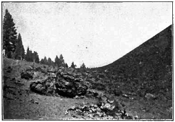
Fig. 228. Volcanic Bombs, Cinder Cone, California
Ancient volcanic rocks. It is in these materials and structures which we have described that volcanoes leave some of their most enduring records. Even the volcanic rocks of the earliest geological ages, uplifted after long burial beneath the sea and exposed to view by deep erosion, are recognized and their history read despite the many changes which they may have undergone. A sheet of ancient lava may be distinguished by its composition from the sediments among which it is imbedded. The direction of its flow lines may be noted. The cellular and slaggy surface where the pasty lava was distended by escaping steam is recognized by the amygdules which now fill the ancient steam blebs. In a pile of successive sheets of lava each flow may be distinguished and its thickness measured; for the surface of each sheet is glassy and scoriaceous, while beneath its upper portions the lava of each flow is more dense and stony. The length of time which elapsed before a sheet was buried beneath the materials of succeeding eruptions may be told by the amount of weathering which it had undergone, the depth of ancient soil—now baked to solid rock—upon it, and the erosion which it had suffered in the interval.
If the flow occurred from some submarine volcano, we may recognize the fact by the sea-laid sediments which cover it, filling the cracks and crevices of its upper surface and containing pieces of lava washed from it in their basal layers.
Long-buried glassy lavas devitrify, or pass to a stony condition, under the unceasing action of underground waters; but their flow lines and perlitic and spherulitic structures remain to tell of their original state.
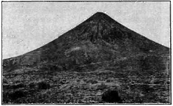
Fig. 229. A Volcanic Cone, Arizona
Ancient tuffs are known by the fragmental character of their volcanic material, even though they have been altered to firm rock. Some remains of land animals and plants may be found imbedded to tell that the beds were laid in open air; while the remains of marine organisms would prove as surely that the tuffs were deposited in the sea.
In these ways ancient volcanoes have been recognized near Boston, in southeastern Pennsylvania, about Lake Superior, and in other regions of the United States.
The Life History of a Volcano
The invasion of a region by volcanic forces is attended by movements of the crust heralded by earthquakes. A fissure or a pipe is opened and the building of the cone or the spreading of wide lava sheets is begun.
Volcanic cones. The shape of a volcanic cone depends chiefly on the materials erupted. Cones made of fragments may have sides as steep as the angle of repose, which in the case of coarse scoria is sometimes as high as thirty or forty degrees. About the base of the mountain the finer materials erupted are spread in more gentle slopes, and are also washed forward by rains and streams. The normal profile is thus a symmetric cone with a flaring base.
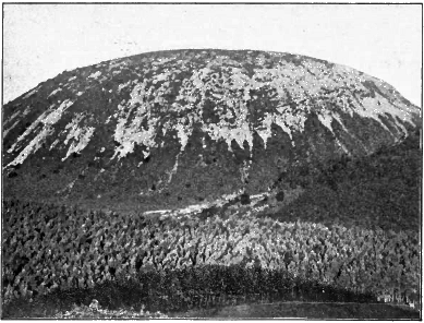
Fig. 230. Sarcoui, a Trachyte Dome, France
Cones built of lava vary in form according to the liquidity of the lava. Domes of gentle slope, as those of Hawaii, for example, are formed of basalt, which flows to long distances before it congeals. When superheated and emitted from many vents, this easily melted lava builds great plateaus, such as that of Iceland. On the other hand, lavas less fusible, or poured out at a lower temperature, stiffen when they have flowed but a short distance, and accumulate in a steep cone. Trachyte has been extruded in a state so viscid that it has formed steepsided domes like that of Sarcoui (Fig. 230).
Most volcanoes are built, like Vesuvius, both of lava flows and of tuffs, and sections show that the structure of the cone consists of outward-dipping, alternating layers of lava, scoria, and ashes.

Fig. 231. Section of Vesuvius
V, Vesuvius; S, Somma, a mountainous rampart half encircling Vesuvius, and like it built of outward-dipping sheets of tuff and lava; a, crystalline rocks; b, marine strata; c, tuffs containing seashells. Which is the older mountain, Vesuvius or Somma? Of what is Somma a remnant? Draw a diagram showing its original outline. Suggest what processes may have brought it to its present form. What record do you find of the earliest volcanic activity? What do you infer as to the beginnings of the volcano?
From time to time the cone is rent by the violence of explosions and by the weight of the column of lava in the pipe. The fissures are filled with lava and some discharge on the sides of the mountain, building parasitic cones, while all form dikes, which strengthen the pile with ribs of hard rock and make it more difficult to rend.
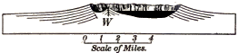
Fig. 232. Crater Lake, Oregon
How wide and deep is the basin which holds the lake? The mountain walls which enclose it are made of outward-dipping sheets of lava. Draw a diagram restoring the volcano of which they are the remnant. No volcanic fragments of the same nature as the materials of which the volcano is built are found about the region. What theory of the destruction of the cone does this fact favor? W´, Wizard Island, is a cinder cone. When was it built?
Great catastrophes are recorded in the shape of some volcanoes which consist of a circular rim perhaps miles in diameter, inclosing a vast crater or a caldera within which small cones may rise. We may infer that at some time the top of the mountain has been blown off, or has collapsed and been engulfed because some reservoir beneath had been emptied by long-continued eruptions (Fig. 232).
The cone-building stage may be said to continue until eruptions of lava and fragmental materials cease altogether. Sooner or later the volcanic forces shift or die away, and no further eruptions add to the pile or replace its losses by erosion during periods of repose. Gases however are still emitted, and, as sulphur vapors are conspicuous among them, such vents are called solfataras. Mount Hood, in Oregon, is an example of a volcano sunk to this stage. From a steaming rift on its side there rise sulphurous fumes which, half a mile down the wind, will tarnish a silver coin.
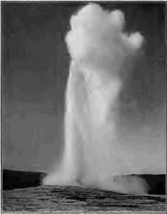
Fig. 233. Old Faithful Geyser in Eruption, Yellowstone National Park
Geysers and hot springs. The hot springs of volcanic regions are among the last vestiges of volcanic heat. Periodically eruptive boiling springs are termed geysers. In each of the geyser regions of the earth—the Yellowstone National Park, Iceland, and New Zealand—the ground water of the locality is supposed to be heated by ancient lavas that, because of the poor conductivity of the rock, still remain hot beneath the surface.
Old Faithful, one of the many geysers of the Yellowstone National Park, plays a fountain of boiling water a hundred feet in air; while clouds of vapor from the escaping steam ascend to several times that height. The eruptions take place at intervals of from seventy to ninety minutes. In repose the geyser is a quiet pool, occupying a craterlike depression in a conical mound some twelve feet high. The conduit of the spring is too irregular to be sounded. The mound is composed of porous silica deposited by the waters of the geyser.
Geysers erupt at intervals instead of continuously boiling, because their long, narrow, and often tortuous conduits do not permit a free circulation of the water. After an eruption the tube is refilled and the water again gradually becomes heated. Deep in the tube where it is in contact with hot lavas the water sooner or later reaches the boiling point, and bursting into steam shoots the water above it high in air.
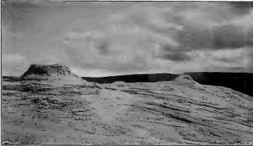
Fig. 234. Terrace and Cones of Siliceous Sinter deposited by Geysers, Yellowstone National Park
Carbonated springs. After all the other signs of life have gone, the ancient volcano may emit carbon dioxide as its dying breath. The springs of the region may long be charged with carbon dioxide, or carbonated, and where they rise through limestone may be expected to deposit large quantities of travertine. We should remember, however, that many carbonated springs, and many hot springs, are wholly independent of volcanoes.
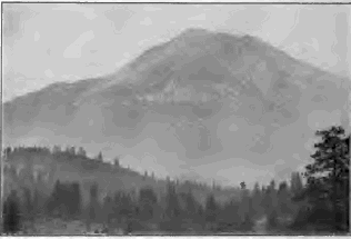
Fig. 235. Mount Shasta, California
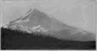
Fig. 236. Mount Hood, Oregon
The destruction of the cone. As soon as the volcanic cone ceases to grow by eruptions the agents of erosion begin to wear it down, and the length of time that has elapsed since the period of active growth may be roughly measured by the degree to which the cone has been dissected. We infer that Mount Shasta, whose conical shape is still preserved despite the gullies one thousand feet deep which trench its sides (Fig. 235), is younger than Mount Hood, which erosive agencies have carved to a pyramidal form (Fig. 236). The pile of materials accumulated about a volcanic vent, no matter how vast in bulk, is at last swept entirely away. The cone of the volcano, active or extinct, is not old as the earth counts time; volcanoes are short- lived geological phenomena.

Fig. 237. Crandall Volcano
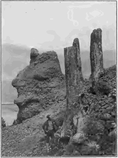
Fig. 238. Fossil Tree Trunks, Yellowstone National Park
Crandall volcano. This name is given to a dissected ancient volcano in the Yellowstone National Park, which once, it is estimated, reared its head thousands of feet above the surrounding country and greatly exceeded in bulk either Mount Shasta or Mount Etna. Not a line of the original mountain remains; all has been swept away by erosion except some four thousand feet of the base of the pile. This basal wreck now appears as a rugged region about thirty miles in diameter, trenched by deep valleys and cut into sharp peaks and precipitous ridges. In the center of the area is found the nucleus (N, Fig. 237),—a mass of coarsely crystalline rock that congealed deep in the old volcanic pipe. From it there radiate in all directions, like the spokes of a wheel, long dikes whose rock grows rapidly finer of grain as it leaves the vicinity of the once heated core. The remainder of the base of the ancient mountain is made of rudely bedded tuffs and volcanic breccia, with occasional flows of lava, some of the fragments of the breccia measuring as much as twenty feet in diameter. On the sides of canyons the breccia is carved by rain erosion to fantastic pinnacles. At different levels in the midst of these beds of tuff and lava are many old forest grounds. The stumps and trunks of the trees, now turned to stone, still in many cases stand upright where once they grew on the slopes of the mountain as it was building (Fig. 238). The great size and age of some of these trees indicate, the lapse of time between the eruption whose lavas or tuffs weathered to the soil on which they grew and the subsequent eruption which buried them beneath showers of stones and ashes.
Near the edge of the area lies Death Gulch, in which carbon dioxide is given off in such quantities that in quiet weather it accumulates in a heavy layer along the ground and suffocates the animals which may enter it.
CHAPTER XII
UNDERGROUND STRUCTURES OF IGNEOUS ORIGIN
It is because long-continued erosion lays bare the innermost anatomy of an extinct volcano, and even sweeps away the entire pile with much of the underlying strata, thus leaving the very roots of the volcano open to view, that we are able to study underground volcanic structures. With these we include, for convenience, intrusions of molten rock which have been driven upward into the crust, but which may not have succeeded in breaking way to the surface and establishing a volcano. All these structures are built of rock forced when in a fluid or pasty state into some cavity which it has found or made, and we may classify them therefore, according to the shape of the molds in which the molten rock has congealed, as (1) dikes, (2) volcanic necks, (3) intrusive sheets, and (4) intrusive masses.
Dikes. The sheet of once molten rock with which a fissure has been filled is known as a dike. Dikes are formed when volcanic cones are rent by explosions or by the weight of the lava column in the duct, and on the dissection of the pile they appear as radiating vertical ribs cutting across the layers of lava and tuff of which the cone is built. In regions undergoing deformation rocks lying deep below the ground are often broken and the fissures are filled with molten rock from beneath, which finds no outlet to the surface. Such dikes are common in areas of the most ancient rocks, which have been brought to light by long erosion.
In exceptional cases dikes may reach the length of fifty or one hundred miles. They vary in width from a fraction of a foot to even as much as three hundred feet.
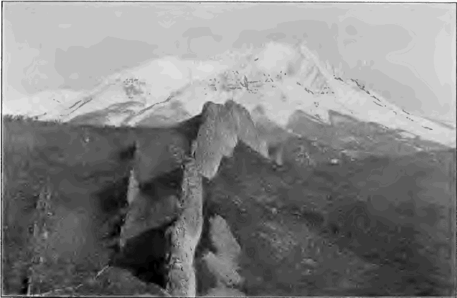
Fig. 239. Dikes, Spanish Peaks, Colorado
Dikes are commonly more fine of grain on the sides than in the center, and may have a glassy and crackled surface where they meet the inclosing rock. Can you account for this on any principle which you have learned?

Fig. 240. A Dissected Volcanic Cone N, volcanic neck; l, l, lava-topped table mountains; t, t, beds of tuff; d, d, dikes; dotted lines indicate the initial profile
Volcanic necks. The pipe of a volcano rises from far below the base of the cone,—from the deep reservoir from which its eruptions are supplied. When the volcano has become extinct this great tube remains filled with hardened lava. It forms a cylindrical core of solid rock, except for some distance below the ancient crater, where it may contain a mass of fragments which had fallen back into the chimney after being hurled into the air.
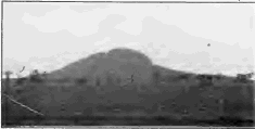
Fig. 241. Mount Johnson, a Volcanic Neck near Montreal
As the mountain is worn down, this central column known as the volcanic neck is left standing as a conical hill (Fig. 240). Even when every other trace of the volcano has been swept away, erosion will not have passed below this great stalk on which the volcano was borne as a fiery flower whose site it remains to mark. In volcanic regions of deep denudation volcanic necks rise solitary and abrupt from the surrounding country as dome-shaped hills. They are marked features in the landscape in parts of Scotland and in the St. Lawrence valley about Montreal (Fig. 241).
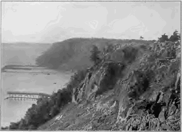
Fig. 242. The Palisades of the Hudson, New Jersey
Intrusive sheets. Sheets of igneous rocks are sometimes found interleaved with sedimentary strata, especially in regions where the rocks have been deformed and have suffered from volcanic action. In some instances such a sheet is seen to be contemporaneous (p. 248). In other instances the sheet must be intrusive. The overlying stratum, as well as that beneath, has been affected by the heat of the once molten rock. We infer that the igneous rock when in a molten state was forced between the strata, much as a card may be pushed between the leaves of a closed book. The liquid wedged its way between the layers, lifting those above to make room for itself. The source of the intrusive sheet may often be traced to some dike (known therefore as the feeding dike), or to some mass of igneous rock.
Intrusive sheets may extend a score and more of miles, and, like the longest surface flows, the most extensive sheets consist of the more fusible and fluid lavas,—those of the basic class of which basalt is an example. Intrusive sheets are usually harder than the strata in which they lie and are therefore often left in relief after long denudation of the region (Fig. 315).

Fig. 243. Diagram of the Palisades of the Hudson i, intrusive sheet; s, sandstone; d, feeding dike; HR, Hudson River
On the west bank of the Hudson there extends from New York Bay north for thirty miles a bold cliff several hundred feet high,— the Palisades of the Hudson. It is the outcropping edge of a sheet of ancient igneous rock, which rests on stratified sandstones and is overlain by strata of the same series. Sandstones and lava sheet together dip gently to the west and the latter disappears from view two miles back from the river.
It is an interesting question whether the Palisades sheet is contemporaneous or intrusive. Was it outpoured on the sandstones beneath it when they formed the floor of the sea, and covered forthwith by the sediments of the strata above, or was it intruded among these beds at a later date?
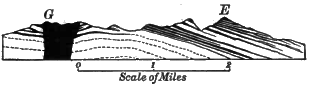
Fig. 244. Section of Electric Peak. E. and Gray Peak, G, Yellowstone National Park Intrusive sheets and masses of igneous rock are drawn in black
The latter is the case: for the overlying stratum is intensely baked along the zone of contact. At the west edge of the sheet is found the dike in which the lava rose to force its way far and wide between the strata.
Electric Peak, one of the prominent mountains of the Yellowstone National Park, is carved out of a mass of strata into which many sheets of molten rock have been intruded. The western summit consists of such a sheet several hundred feet thick. Studying the section of Figure 244, what inference do you draw as to the source of these intrusive sheets?
Intrusive Masses
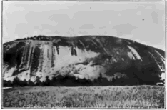
Fig. 245. Stone Mountain, Georgia, a Granite Boss
Bosses. This name is generally applied to huge irregular masses of coarsely crystalline igneous rock lying in the midst of other formations. Bosses vary greatly in size and may reach scores of miles in extent. Seldom are there any evidences found that bosses ever had connection with the surface. On the other hand, it is often proved that they have been driven, or have melted their way, upward into the formations in which they lie; for they give off dikes and intrusive sheets, and have profoundly altered the rocks about them by their heat.
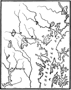
Fig. 246. Map of Granite Bosses near Baltimore (areas horizontally Lined)
The texture of the rock of bosses proves that consolidation proceeded slowly and at great depths, and it is only because of vast denudation that they are now exposed to view. Bosses are commonly harder than the rocks about them, and stand up, therefore, as rounded hills and mountainous ridges long after the surrounding country has worn to a low plain (Fig. 245).
Figure 246 exhibits a few small bosses of granite near Baltimore as examples of numerous areas of igneous rock within the Piedmont Belt which represent bodies of molten rock which solidified deep below the surface.
The Spanish Peaks of southeastern Colorado were formed by the upthrust of immense masses of igneous rock, bulging and breaking the overlying strata. On one side of the mountains the throw of the fault is nearly a mile, and fragments of deep-lying beds were dragged upward by the rising masses. The adjacent rocks were altered by heat to a distance of several thousand feet. No evidence appears that the molten rock ever reached the surface, and if volcanic eruptions ever took place either in lava flows or fragmental materials, all traces of them have been effaced. The rock of the intrusive masses is coarsely crystalline, and no doubt solidified slowly under the pressure of vast thicknesses of overlying rock, now mostly removed by erosion.
A magnificent system of dikes radiates from the Peaks to a distance of fifteen miles, some now being left by long erosion as walls a hundred feet in height (Fig. 239). Intrusive sheets fed by the dikes penetrate the surrounding strata, and their edges are cut by canyons as much as twenty-five miles from the mountain. In these strata are valuable beds of lignite, an imperfect coal, which the heat of dikes and sheets has changed to coke.
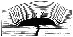
Fig. 247. Section of a Laccolith
Laccoliths. The laccolith (Greek laccos, cistern; lithos, stone) is a variety of intrusive masses in which molten rock has spread between the strata, and, lifting the strata above it to a dome- shaped form, has collected beneath them in a lens-shaped body with a flat base.
The Henry Mountains, a small group of detached peaks in southern Utah, rise from a plateau of horizontal rocks. Some of the peaks are carved wholly in separate domelike uplifts of the strata of the plateau. In others, as Mount Hillers, the largest of the group, there is exposed on the summit a core of igneous rock from which the sedimentary rocks of the flanks dip steeply outward in all directions. In still others erosion has stripped off the covering strata and has laid bare the core to its base; and its shape is here seen to be that of a plano-convex lens or a baker’s bun, its flat base resting on the undisturbed bedded rocks beneath. The structure of Mount Hillers is shown in Figure 248. The nucleus of igneous rock is four miles in diameter and more than a mile in depth.
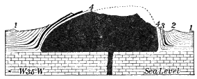
Fig. 248. Section of Mount Hillers
Regional intrusions. These vast bodies of igneous rock, which may reach hundreds of miles in diameter, differ little from bosses except in their immense bulk. Like bosses, regional intrusions give off dikes and sheets and greatly change the rocks about them by their heat. They are now exposed to view only because of the profound denudation which has removed the upheaved dome of rocks beneath which they slowly cooled. Such intrusions are accompanied —whether as cause or as effect is still hardly known—by deformations, and their masses of igneous rock are thus found as the core of many great mountain ranges. The granitic masses of which the Bitter Root Mountains and the Sierra Nevadas have been largely carved are each more than three hundred miles in length. Immense regional intrusions, the cores of once lofty mountain ranges, are found upon the Laurentian peneplain.
Physiographic effects of intrusive masses. We have already seen examples of the topographic effects of intrusive masses in Mount Hillers, the Spanish Peaks, and in the great mountain ranges mentioned in the paragraph on regional intrusions, although in the latter instances these effects are entangled with the effects of other processes. Masses of igneous rock cannot be intruded within the crust without an accompanying deformation on a scale corresponding to the bulk of the intruded mass. The overlying strata are arched into hills or mountains, or, if the molten material is of great extent, the strata may conceivably be floated upward to the height of a plateau. We may suppose that the transference of molten matter from one region to another may be among the causes of slow subsidences and elevations. Intrusions give rise to fissures, dikes, and intrusive sheets, and these dislocations cannot fail to produce earthquakes. Where intrusive masses open communication with the surface, volcanoes are established or fissure eruptions occur such as those of Iceland.
The Intrusive Rocks
The igneous rocks are divided into two general classes,—the volcanic or eruptive rocks, which have been outpoured in open air or on the floor of the sea, and the intrusive rocks, which have been intruded within the rocks of the crust and have solidified below the surface. The two classes are alike in chemical composition and may be divided into acidic and basic groups. In texture the intrusive rocks differ from the volcanic rocks because of the different conditions under which they have solidified. They cooled far more slowly beneath the cover of the rocks into which they were pressed than is permitted to lava flows in open air. Their constituent minerals had ample opportunity to sort themselves and crystallize from the fluid mixture, and none of that mixture was left to congeal as a glassy paste.
They consolidated also under pressure. They are never scoriaceous, for the steam with which they were charged was not allowed to expand and distend them with steam blebs. In the rocks of the larger intrusive masses one may see with a powerful microscope exceedingly minute cavities, to be counted by many millions to the cubic inch, in which the gaseous water which the mass contained was held imprisoned under the immense pressure of the overlying rocks.
Naturally these characteristics are best developed in the intrusives which cooled most slowly, i.e. in the deepest-seated and largest masses; while in those which cooled more rapidly, as in dikes and sheets, we find gradations approaching the texture of surface flows.
Varieties of the intrusive rocks. We will now describe a few of the varieties of rocks of deep-seated intrusions. All are even grained, consisting of a mass of crystalline grains formed during one continuous stage of solidification, and no porphyritic crystals appear as in lavas.
Granite, as we have learned already, is composed of three minerals,—quartz, feldspar, and mica. According to the color of the feldspar the rock may be red, or pink, or gray. Hornblende—a black or dark green mineral, an iron-magnesian silicate, about as hard as feldspar—is sometimes found as a fourth constituent, and the rock is then known as hornblendic granite. Granite is an acidic rock corresponding to rhyolite in chemical composition. We may believe that the same molten mass which supplies this acidic lava in surface flows solidifies as granite deep below ground in the volcanic reservoir.
Syenite, composed of feldspar and mica, has consolidated from a less siliceous mixture than has granite.
Diorite, still less siliceous, is composed of hornblende and feldspar,—the latter mineral being of different variety from the feldspar of granite and syenite.
Gabbro, a typical basic rock, corresponds to basalt in chemical composition. It is a dark, heavy, coarsely crystalline aggregate of feldspar and augite (a dark mineral allied to hornblende). It often contains magnetite (the magnetic black oxide of iron) and olivine (a greenish magnesian silicate).
In the northern states all these types, and many others also of the vast number of varieties of intrusive rocks, can be found among the rocks of the drift brought from the areas of igneous rock in Canada and the states of our northern border.
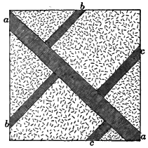
Fig. 249. Ground Plan of Dikes in Granite. (Scale 80 feet to the inch) What is the relative age of the dikes aa, bb, and cc?
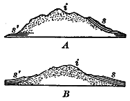
Fig. 250. A and B. Mountains of coarsely Crystalline Igneous i, surrounded by Sedimentary Strata s and s´
Copy each diagram and complete it, so as to show whether the mass of igneous rock is a volcanic neck, a boss, or a laccolith
Summary. The records of geology prove that since the earliest of their annals tremendous forces have been active in the earth. In all the past, under pressures inconceivably great, molten rock has been driven upward into the rocks of the crust. It has squeezed into fissures forming dikes; it has burrowed among the strata as intrusive sheets; it has melted the rocks away or lifted the overlying strata, filling the chambers which it has made with intrusive masses. During all geological ages molten rock has found way to the surface, and volcanoes have darkened the sky with clouds of ashes and poured streams of glowing lava down their sides. The older strata,—the strata which have been most deeply buried,—and especially those which have suffered most from folding and from fracture, show the largest amount of igneous intrusions. The molten rock which has been driven from the earth’s interior to within the crust or to the surface during geologic time must be reckoned in millions of cubic miles.
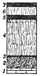
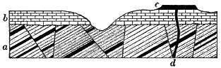
Fig. 251. 1, limestone; 2, tuff; 3, 5, 7, shale with marine shells; 4, 6, lava, dotted portions scoriaceous. Give the history recorded in this section Fig. 252. a, sedimentary strata with intrusive sheets; b, sedimentary strata; c, lava flow; d, dike. Give the succession of events recorded in this section
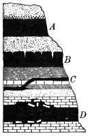
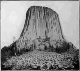
Fig. 253. Which of the lava sheets of this section are contemporaneous anti which intrusive,—A, whose upper surface is overlain with a conglomerate of rolled lava pebbles; B, the cracks and seams of whose upper surface are filled with the material of the overlying sandstone; C, which breaks across the strata in which it is imbedded; D, which includes fragments of both the underlying and overlying strata and penetrates their crevices and seams? Fig. 254. Mato Tepee, Wyoming This magnificent tower of igneous rock three hundred feet in height has been called by some a volcanic neck. Is the direction of the columns that which would obtain in the cylindrical pipe of a volcano? The tower is probably the remnant of a small laccolith, an outlying member of a group of laccoliths situated not far distant
The Interior Condition of the Earth and Causes of Vulcanism and Deformation
The problems of volcanoes and of deformation are so closely connected with that of the earth’s interior that we may consider them together. Few of these problems are solved, and we may only state some known facts and the probable conclusions which may be drawn as inferences from them.
The interior of the earth is hot. Volcanoes prove that in many parts of the earth there exist within reach of the surface regions of such intense heat that the rock is in a molten condition. Deep wells and mines show everywhere an increase in temperature below the surface shell affected by the heat of summer and the cold of winter,—a shell in temperate latitudes sixty or seventy feet thick. Thus in a boring more than a mile deep at Schladebach, Germany, the earth grows warmer at the rate of 1° F. for every sixty-seven feet as we descend. Taking the average rate of increase at one degree for every sixty feet of descent, and assuming that this rate, observed at the moderate distances open to observation, continues to at least thirty-five miles, the temperature at that depth must be more than three thousand degrees,—a temperature at which all ordinary rocks would melt at the earth’s surface. The rate of increase in temperature probably lessens as we go downward, and it may not be appreciable below a few hundred miles. But there is no reason to doubt that the interior of the earth is intensely hot. Below a depth of one or two score miles we may imagine the rocks everywhere glowing with heat.
Although the heat of the interior is great enough to melt all rocks at atmospheric pressure, it does not follow that the interior is fluid. Pressure raises the fusing point of rocks, and the weight of the crust may keep the interior in what may be called a solid state, although so hot as to be a liquid or a gas were the pressure to be removed.
The interior of the earth is dense and heavy. The earth behaves as a globe more rigid than glass under the strains to which it is subjected by the attractions of the sun and moon and other heavenly bodies. The jar of world-shaking earthquakes passes through the earth’s interior with nearly twice the velocity with which it would traverse solid steel, and since the speed of elastic waves depends on the density and elasticity of the medium, it follows that the globe is as a whole more dense and rigid than steel. The interior of the earth is extremely dense and rigid.
The common rocks of the crust are about two and a half times heavier than water, while the earth as a whole weighs five and six-tenths times as much as a globe of water of the same size. The interior is therefore much more heavy than the crust. This may be caused in part by compression of the interior under the enormous weight of the crust, and in part also by an assortment of material, the heavier substances, such as the heavy metals, having gravitated towards the center.
Between the crust, which is solid because it is cool, and the interior, which is hot enough to melt were it not for the pressure which keeps it dense and rigid, there may be an intermediate zone in which heat and pressure are so evenly balanced that here rock liquefies whenever and wherever the pressure upon it may be relieved by movements of the crust. It is perhaps from such a subcrustal layer that the lava of volcanoes is supplied.
The causes of volcanic action. It is now generally believed that the heat of volcanoes is that of the earth’s interior. Other causes, such as friction and crushing in the making of mountains and the chemical reactions between oxidizing agents of the crust and the unoxidized interior, have been suggested, but to most geologists they seem inadequate.
There is much difference of opinion as to the force which causes molten rock to rise to the surface in the ducts of volcanoes. Steam is so evidently concerned in explosive eruptions that many believe that lava is driven upward by the expansive force of the steam with which it is charged, much as a viscid liquid rises and boils over in a test tube or kettle.
But in quiet eruptions, and still more in the irruption of intrusive sheets and masses, there is little if any evidence that steam is the driving force. It is therefore believed by many geologists that it is pressure due to crustal movements and internal stresses which squeezes molten rock from below into fissures and ducts in the crust. It is held by some that where considerable water is supplied to the rising column of lava, as from the ground water of the surrounding region, and where the lava is viscid so that steam does not readily escape, the eruption is of the explosive type; when these conditions do not obtain, the lava outwells quietly, as in the Hawaiian volcanoes. It is held by others not only that volcanoes are due to the outflow of the earth’s deep-seated heat, but also that the steam and other emitted gases are for the most part native to the earth’s interior and never have had place in the circulation of atmospheric and ground waters.
Volcanic action and deformation. Volcanoes do not occur on wide plains or among ancient mountains. On the other hand, where movements of the earth’s crust are in progress in the uplift of high plateaus, and still more in mountain making, molten rock may reach the surface, or may be driven upward toward it forming great intrusive masses. Thus extensive lava flows accompanied the upheaval of the block mountains of western North America and the uplift of the Colorado plateau. A line of recent volcanoes may be traced along the system of rift valleys which extends from the Jordan and Dead Sea through eastern Africa to Lake Nyassa. The volcanoes of the Andes show how conspicuous volcanic action may be in young rising ranges. Folded mountains often show a core of igneous rock, which by long erosion has come to form the axis and the highest peaks of the range, as if the molten rock had been squeezed up under the rising upfolds. As we decipher the records of the rocks in historical geology we shall see more fully how, in all the past, volcanic action has characterized the periods of great crustal movements, and how it has been absent when and where the earth’s crust has remained comparatively at rest.
The causes of deformation. As the earth’s interior, or nucleus, is highly heated it must be constantly though slowly losing its heat by conduction through the crust and into space; and since the nucleus is cooling it must also be contracting. The nucleus has contracted also because of the extrusion of molten matter, the loss of constituent gases given off in volcanic eruptions, and (still more important) the compression and consolidation of its material under gravity. As the nucleus contracts, it tends to draw away from the cooled and solid crust, and the latter settles, adapting itself to the shrinking nucleus much as the skin of a withering apple wrinkles down upon the shrunken fruit. The unsupported weight of the spherical crust develops enormous tangential pressures, similar to the stresses of an arch or dome, and when these lateral thrusts accumulate beyond the power of resistance the solid rock is warped and folded and broken.
Since the planet attained its present mass it has thus been lessening in volume. Notwithstanding local and relative upheavals the earth’s surface on the whole has drawn nearer and nearer to the center. The portions of the lithosphere which have been carried down the farthest have received the waters of the oceans, while those portions which have been carried down the least have emerged as continents.
Although it serves our convenience to refer the movements of the crust to the sea level as datum plane, it is understood that this level is by no means fixed. Changes in the ocean basins increase or reduce their capacity and thus lower or raise the level of the sea. But since these basins are connected, the effect of any change upon the water level is so distributed that it is far less noticeable than a corresponding change would be upon the land.
CHAPTER XIII
METAMORPHISM AND MINERAL VEINS
Under the action of internal agencies rocks of all kinds may be rendered harder, more firmly cemented, and more crystalline. These processes are known as metamorphism, and the rocks affected, whether originally sedimentary or igneous, are called metamorphic rocks. We may contrast with metamorphism the action of external agencies in weathering, which render rocks less coherent by dissolving their soluble parts and breaking down their crystalline grains.
Contact metamorphism. Rocks beneath a lava flow or in contact with igneous intrusions are found to be metamorphosed to various degrees by the heat of the cooling mass. The adjacent strata may be changed only in color, hardness, and texture. Thus, next to a dike, bituminous coal may be baked to coke or anthracite, and chalk and limestone to crystalline marble. Sandstone may be converted into quartzite, and shale into argillite, a compact, massive clay rock. New minerals may also be developed. In sedimentary rocks there may be produced crystals of mica and of garnet (a mineral as hard as quartz, commonly occurring in red, twelve-sided crystals). Where the changes are most profound, rocks may be wholly made over in structure and mineral composition.
In contact metamorphism, thin sheets of molten rock produce less effect than thicker ones. The strongest heat effects are naturally caused by bosses and regional intrusions, and the zone of change about them may be several miles in width. In these changes heated waters and vapors from the masses of igneous rocks undoubtedly play a very important part.
Which will be more strongly altered, the rocks about a closed dike in which lava began to cool as soon as it filled the fissure, or the rocks about a dike which opened on the surface and through which the molten rock flowed for some time?
Taking into consideration the part played by heated waters, which will produce the most far-reaching metamorphism, dikes which cut across the bedding planes or intrusive sheets which are thrust between the strata?
Regional metamorphism. Metamorphic rocks occur wide-spread in many regions, often hundreds of square miles in area, where such extensive changes cannot be accounted for by igneous intrusions. Such are the dissected cores of lofty mountains, as the Alps, and the worn-down bases of ancient ranges, as in New England, large areas in the Piedmont Belt, and the Laurentian peneplain.
In these regions the rocks have yielded to immense pressure. They have been folded, crumpled, and mashed, and even their minute grains, as one may see with a microscope, have often been puckered, broken, and crushed to powder. It is to these mechanical movements and strains which the rocks have suffered in every part that we may attribute their metamorphism, and the degree to which they have been changed is in direct proportion to the degree to which they have been deformed and mashed.
Other factors, however, have played important parts. Rock crushing develops heat, and allows a freer circulation of heated waters and vapors. Thus chemical reactions are greatly quickened; minerals are dissolved and redeposited in new positions, or their chemical constituents may recombine in new minerals, entirely changing the nature of the rock, as when, for example, feldspar recrystallizes as quartz and mica.
Early stages of metamorphism are seen in slate. Pressure has hardened the marine muds, the arkose (p. 186), or the volcanic ash from which slates are derived, and has caused them to cleave by the rearrangement of their particles.
Under somewhat greater pressure, slate becomes phyllite, a clay slate whose cleavage surfaces are lustrous with flat-lying mica flakes. The same pressure which has caused the rock to cleave has set free some of its mineral constituents along the cleavage planes to crystallize there as mica.
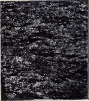
Fig. 255. A Foliated Rock
Foliation. Under still stronger pressure the whole structure of the rock is altered. The minerals of which it is composed, and the new minerals which develop by heat and pressure, arrange themselves along planes of cleavage or of shear in rudely parallel leaves, or folia. Of this structure, called foliation, we may distinguish two types,—a coarser feldspathic type, and a fine type in which other minerals than feldspar predominate.
Gneiss is the general name under which are comprised coarsely foliated rocks banded with irregular layers of feldspar and other minerals. The gneisses appear to be due in many cases to the crushing and shearing of deep-seated igneous rocks, such as granite and gabbro.
The crystalline schists, representing the finer types of foliation, consist of thin, parallel, crystalline leaves, which are often remarkably crumpled. These folia can be distinguished from the laminae of sedimentary rocks by their lenticular form and lack of continuity, and especially by the fact that they consist of platy, crystalline grains, and not of particles rounded by wear.
Mica schist, the most common of schists, and in fact of all metamorphic rocks, is composed of mica and quartz in alternating wavy folia. All gradations between it and phyllite may be traced, and in many cases we may prove it due to the metamorphism of slates and shales. It is widespread in New England and along the eastern side of the Appalachians. Talc schist consists of quartz and talc, a light-colored magnesian mineral of greasy feel, and so soft that it can be scratched with the thumb nail.
Hornblende schist, resulting in many cases from the foliation of basic igneous rocks, is made of folia of hornblende alternating with bands of quartz and feldspar. Hornblende schist is common over large areas in the Lake Superior region.
Quartz schist is produced from quartzite by the development of fine folia of mica along planes of shear. All gradations may be found between it and unfoliated quartzite on the one hand and mica schist on the other.
Under the resistless pressure of crustal movements almost any rocks, sandstones, shales, lavas of all kinds, granites, diorites, and gabbros may be metamorphosed into schists by crushing and shearing. Limestones, however, are metamorphosed by pressure into marble, the grains of carbonate of lime recrystallizing freely to interlocking crystals of calcite.
These few examples must suffice of the great class of metamorphic rocks. As we have seen, they owe their origin to the alteration of both of the other classes of rocks—the sedimentary and the igneous—by heat and pressure, assisted usually by the presence of water. The fact of change is seen in their hardness arid cementation, their more or less complete recrystallization, and their foliation; but the change is often so complete that no trace of their original structure and mineral composition remains to tell whether the rocks from which they were derived were sedimentary or igneous, or to what variety of either of these classes they belonged.
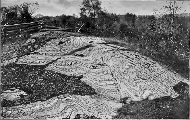
Fig. 256. Contorted Gneiss, the Ottawa River, Canada
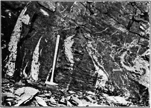
Fig. 257. Quartz Veins in Slate
In many cases, however, the early history of a metamorphic rock can be deciphered. Fossils not wholly obliterated may prove it originally water-laid. Schists may contain rolled-out pebbles, showing their derivation from a conglomerate. Dikes of igneous rocks may be followed into a region where they have been foliated by pressure. The most thoroughly metamorphosed rocks may sometimes be traced out into unaltered sedimentary or igneous rocks, or among them may be found patches of little change where their history maybe read.
Metamorphism is most common among rocks of the earlier geological ages, and most rare among rocks of recent formation. No doubt it is now in progress where deep-buried sediments are invaded by heat either from intrusive igneous masses or from the earth’s interior, or are suffering slow deformation under the thrust of mountain-making forces.
Suggest how rocks now in process of metamorphism may sometimes be exposed to view. Why do metamorphic rocks appear on the surface to-day?
Mineral Veins
In regions of folded and broken rocks fissures are frequently found to be filled with sheets of crystalline minerals deposited from solution by underground water, and fissures thus filled are known as mineral veins. Much of the importance of mineral veins is due to the fact that they are often metalliferous, carrying valuable native metals and metallic ores disseminated in fine particles, in strings, and sometimes in large masses in the midst of the valueless nonmetallic minerals which make up what is known as the vein stone.
The most common vein stones are quartz and calcite. fluorite (calcium fluoride), a mineral harder than calcite and crystallizing in cubes of various colors, and barite (barium sulphate), a heavy white mineral, are abundant in many veins.
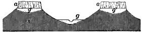
Fig. 258. Placer Deposits in California g, gold-bearing gravels in present river beds; g´, ancient gold-bearing river gravels; a, a, lava flows capping table mountains; s, slate. Draw a diagram showing by dotted lines conditions before the lava flows occurred. What changes have since taken place?
The gold-bearing quartz veins of California traverse the metamorphic slates of the Sierra Nevada Mountains. Below the zone of solution (p. 45) these veins consist of a vein stone of quartz mingled with pyrite (p. 13), the latter containing threads and grains of native gold. But to the depth of about fifty feet from the surface the pyrite of the vein has been dissolved, leaving a rusty, cellular quartz with grains of the insoluble gold scattered through it.
The placer deposits of California and other regions are gold- bearing deposits of gravel and sand in river beds. The heavy gold is apt to be found mostly near or upon the solid rock, and its grains, like those of the sand, are always rounded. How the gold came in the placers we may leave the pupil to suggest.
Copper is found in a number of ores, and also in the native metal. Below the zone of surface changes the ore of a copper vein is often a double sulphide of iron and copper called chalcopyrite, a mineral softer than pyrite—it can easily be scratched with a knife—and deeper yellow in color. For several score of feet below the ground the vein may consist of rusty quartz from which the metallic ores have been dissolved; but at the base of the zone of solution we may find exceedingly rich deposits of copper ores,— copper sulphides, red and black copper oxides, and green and blue copper carbonates, which have clearly been brought down in solution from the leached upper portion of the vein.
Origin of mineral veins. Both vein stones and ores have been deposited slowly from solution in water, much as crystals of salt are deposited on the sides of a jar of saturated brine. In our study of underground water we learned that it is everywhere circulating through the permeable rocks of the crust, descending to profound depths under the action of gravity and again driven to the surface by hydrostatic pressure. Now fissures, wherever they occur, form the trunk channels of the underground circulation. Water descends from the surface along these rifts; it moves laterally from either side to the fissure plane, just as ground water seeps through the surrounding rocks from every direction to a well; and it ascends through these natural water ways as in an artesian well, whenever they intersect an aquifer in which water is under hydrostatic pressure.
The waters which deposit vein stones and ores are commonly hot, and in many cases they have derived their heat from intrusions of igneous rock still uncooled within the crust. The solvent power of the water is thus greatly increased, and it takes up into solution various substances from the igneous and sedimentary rocks which it traverses. For various reasons these substances stances are deposited in the vein as ores and vein stones. On rising through the fissure the water cools and loses pressure, and its capacity to hold minerals in solution is therefore lessened. Besides, as different currents meet in the fissure, some ascending, some descending, and some coming in from the sides, the chemical reaction of these various weak solutions upon one another and upon the walls of the vein precipitates the minerals of vein stuffs and ores.
As an illustration of the method of vein deposits we may cite the case of a wooden box pipe used in the Comstock mines, Nevada, to carry the hot water of the mine from one level to another, which in ten years was lined with calcium carbonate more than half an inch thick.
The Steamboat Springs, Nevada, furnish examples of mineral veins in process of formation. The steaming water rises through fissures in volcanic rocks and is now depositing in the rifts a vein stone of quartz, with metallic ores of iron, mercury, lead, and other metals.
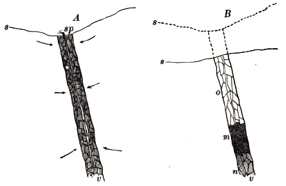
Fig. 259. Reconcentration of Ores in Mineral Veins A, original vein; B, same after reconcentration; v, mineral vein; s, surface of ground (dotted line, former surfaces of the ground); sp, spring; o, vein leached of ores by descending waters in zone of solution; m, rich ore deposits reconcentrated from above; n, unchanged portion of vein
Reconcentration. Near the base of the zone of solution veins are often stored with exceptionally large and valuable ore deposits. This local enrichment of the vein is due to the reconcentration of its metalliferous ores. As the surface of the land is slowly lowered by weathering and running water, the zone of solution is lowered at an equal rate and encroaches constantly on the zone of cementation. The minerals of veins are therefore constantly being dissolved along their upper portions and carried down the fissures by ground water to lower levels, where they are redeposited.
Many of the richest ore deposits are thus due to successive concentrations: the ores were leached originally from the rocks to a large extent by laterally seeping waters; they were concentrated in the ore deposits of the vein chiefly by ascending currents; they have been reconcentrated by descending waters in the way just mentioned.
The original source of the metals. It is to the igneous rocks that we may look for the original source of the metals of veins. Lavas contain minute percentages of various metallic compounds, and no doubt this was the case also with the igneous rocks which formed the original earth crust. By the erosion of the igneous rocks the metals have been distributed among sedimentary strata, and even the sea has taken into solution an appreciable amount of gold and other metals, but in this widely diffused condition they are wholly useless to man. The concentration which has made them available is due to the interaction of many agencies. Earth movements fracturing deeply the rocks of the crust, the intrusion of heated masses, the circulation of underground waters, have all cooperated in the concentration of the metals of mineral veins.
While fissure veins are the most important of mineral veins, the latter term is applied also to any water way which has been filled by similar deposits from solution. Thus in soluble rocks, such as limestones, joints enlarged by percolating water are sometimes filled with metalliferous deposits, as, for example, the lead and zinc deposits of the upper Mississippi valley. Even a porous aquifer may be made the seat of mineral deposits, as in the case of some copper-bearing and silver-bearing sandstones of New Mexico.
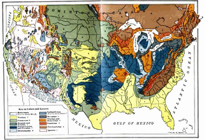
Fig. 260. Geological Map of the United states and Part of Canada Click on map to view larger version
PART III
HISTORICAL GEOLOGY
CHAPTER XIV
THE GEOLOGICAL RECORD
What a formation records. We have already learned that each individual body of stratified rock, or formation, constitutes a record of the time when it was laid. The structure and the character of the sediments of each formation tell whether the area was land or sea at the time when they were spread; and if the former, whether the land was river plain, or lake bed, or was covered with wind-blown sands, or by the deposits of an ice sheet. If the sediments are marine, we may know also whether they were laid in shoal water near the shore or in deeper water out at sea, and whether during a period of emergence, or during a period of subsidence when the sea transgressed the land. By the same means each formation records the stage in the cycle of erosion of the land mass from which its sediments were derived (p. 185). An unconformity between two marine formations records the fact that between the periods when they were deposited in the sea the area emerged as land and suffered erosion (p. 227). The attitude and structure of the strata tell also of the foldings and fractures, the deformation and the metamorphism, which they have suffered; and the igneous rocks associated with them as lava flows and igneous intrusions add other details to the story. Each formation is thus a separate local chapter in the geological history of the earth, and its strata are its leaves. It contains an authentic record of the physical conditions—the geography—of the time and place when and where its sediments were laid.
Past cycles of erosion. These chapters in the history of the planet are very numerous, although much of the record has been destroyed in various ways. A succession of different formations is usually seen in any considerable section of the crust, such as a deep canyon or where the edges of upturned strata are exposed to view on the flanks of mountain ranges; and in any extensive area, such as a state of the Union or a province of Canada, the number of formations outcropping on the surface is large.
It is thus learned that our present continent is made up for the most part of old continental deltas. Some, recently emerged as the strata of young coastal plains, are the records of recent cycles of erosion; while others were deposited in the early history of the earth, and in many instances have been crumpled into mountains, which afterwards were leveled to their bases and lowered beneath the sea to receive a cover of later sediments before they were again uplifted to form land.
The cycle of erosion now in progress and recorded in the layers of stratified rock being spread beneath the sea in continental deltas has therefore been preceded by many similar cycles. Again and again movements of the crust have brought to an end one cycle— sometimes when only well under way, and sometimes when drawing toward its close—and have begun another. Again and again they have added to the land areas which before were sea, with all their deposition records of earlier cycles, or have lowered areas of land beneath the sea to receive new sediments.
The age of the earth. The thickness of the stratified rocks now exposed upon the eroded surface of the continents is very great. In the Appalachian region the strata are seven or eight miles thick, and still greater thicknesses have been measured in several other mountain ranges. The aggregate thickness of all the formations of the stratified rocks of the earth’s crust, giving to each formation its maximum thickness wherever found, amounts to not less than forty miles. Knowing how slowly sediments accumulate upon the sea floor (p.184), we must believe that the successive cycles which the earth has seen stretch back into a past almost inconceivably remote, and measure tens of millions and perhaps even hundreds of millions of years.
How the formations are correlated and the geological record made up. Arranged in the order of their succession, the formations of the earth’s crust would constitute a connected record in which the geological history of the planet may be read, and therefore known as the geological record. But to arrange the formations in their natural order is not an easy task. A complete set of the volumes of the record is to be found in no single region. Their leaves and chapters are scattered over the land surface of the globe. In one area certain chapters may be found, though perhaps with many missing leaves, and with intervening chapters wanting, and these absent parts perhaps can be supplied only after long search through many other regions.
Adjacent strata in any region are arranged according to the law of superposition, i.e. any stratum is younger than that on which it was deposited, just as in a pile of paper, any sheet was laid later than that on which it rests. Where rocks have been disturbed, their original attitude must be determined before the law can be applied. Nor can the law of superposition be used in identifying and comparing the strata of different regions where the formations cannot be traced continuously from one region to the other.
The formations of different regions are arranged in their true order by the law of included organisms; i.e. formations, however widely separated, which contain a similar assemblage of fossils are equivalent and belong to the same division of geological time.
The correlation of formations by means of fossils may be explained by the formations now being deposited about the north Atlantic. Lithologically they are extremely various. On the continental shelf of North America limestones of different kinds are forming off Florida, and sandstones and shales from Georgia northward. Separated from them by the deep Atlantic oozes are other sedimentary deposits now accumulating along the west coast of Europe. If now all these offshore formations were raised to open air, how could they be correlated? Surely not by lithological likeness, for in this respect they would be quite diverse. All would be similar, however, in the fossils which they contain. Some fossil species would be identical in all these formations and others would be closely allied. Making all due allowance for differences in species due to local differences in climate and other physical causes, it would still be plain that plants and animals so similar lived at the same period of time, and that the formations in which their remains were imbedded were contemporaneous in a broad way. The presence of the bones of whales and other marine mammals would prove that the strata were laid after the appearance of mammals upon earth, and imbedded relics of man would give a still closer approximation to their age. In the same way we correlate the earlier geological formations.
For example, in 1902 there were collected the first fossils ever found on the antarctic continent. Among the dozen specimens obtained were some fossil ammonites (a family of chambered shells) of genera which are found on other continents in certain formations classified as the Cretaceous system, and which occur neither above these formations nor below them. On the basis of these few fossils we may be confident that the strata in which they were found in the antarctic region were laid in the same period of geologic time as were the Cretaceous rocks of the United States and Canada.
The record as a time scale. By means of the law of included organisms and the law of superposition the formations of different countries and continents are correlated and arranged in their natural order. When the geological record is thus obtained it may be used as a universal time scale for geological history. Geological time is separated into divisions corresponding to the times during which the successive formations were laid. The largest assemblages of formations are known as groups, while the corresponding divisions of time are known as eras. Groups are subdivided into systems, and systems into series. Series are divided into stages and substages,—subdivisions which do not concern us in this brief treatise. The corresponding divisions of time are given in the following table.
Strata Time
Group Era
System Period
Series Epoch
The geologist is now prepared to read the physical history—the geographical development—of any country or of any continent by means of its formations, when he has given each formation its true place in the geological record as a time scale.
The following chart exhibits the main divisions of the record, the name given to each being given also to the corresponding time division. Thus we speak of the Cambrian system, meaning a certain succession of formations which are classified together because of broad resemblances in their included organisms; and of the Cambrian period, meaning the time during which these rocks were deposited.
Group and Era System and Period Series and Epoch
Cenozoic Quaternary Recent Pleistocene


Tertiary Pliocene Miocene Eocene
Mesozoic Cretaceous Jurassic Triassic
Paleozoic Carboniferous Permian Pennsylvanian Mississippian
Devonian Silurian Ordovician Cambrian
Algonkian
Archean
Fossils and what they teach
The geological formations contain a record still more important than that of the geographical development of the continents; the fossils imbedded in the rocks of each formation tell of the kinds of animals and plants which inhabited the earth at that time, and from these fossils we are therefore able to construct the history of life upon the earth.
Fossils. These remains of organisms are found in the strata in all degrees of perfection, from trails and tracks and fragmentary impressions, to perfectly preserved shells, wood, bones, and complete skeletons. As a rule, it is only the hard parts of animals and plants which have left any traces in the rocks. Sometimes the original hard substance is preserved, but more often it has been replaced by some less soluble material. Petrifaction, as this process of slow replacement is called, is often carried on in the most exquisite detail. When wood, for example, is undergoing petrifaction, the woody tissue may be replaced, particle by particle, by silica in solution through the action of underground waters, even the microscopic structures of the wood being perfectly reproduced. In shells originally made of aragonite, a crystalline form of carbonate of lime, that mineral is usually replaced by calcite, a more stable form of the same substance. The most common petrifying materials are calcite, silica, and pyrite (p. 13).
Often the organic substance has neither been preserved nor replaced, but the form has been retained by means of molds and casts. Permanent impressions, or molds, may be made in sediments not only by the hard parts of organisms, but also by such soft and perishable parts as the leaves of plants, and, in the rarest instances, by the skin of animals and the feathers of birds. In fine-grained limestones even the imprints of jellyfish have been retained.
Fig. 261. Section of Cast and Mold of a Shell a, shell; b, mold of exterior; c, cast of interior
The different kinds of molds and casts may be illustrated by means of a clam shell and some moist clay, the latter representing the sediments in which the remains of animals and plants are entombed. Imbedding the shell in the clay and allowing the clay to harden, we have a mold of the exterior of the shell, as is seen on cutting the clay matrix in two and removing the shell from it. Filling this mold with clay of different color, we obtain a cast of the exterior, which represents accurately the original form and surface markings of the shell. In nature, shells and other relics of animals or plants are often removed by being dissolved by percolating waters, and the molds are either filled with sediments or with minerals deposited from solution.
Where the fossil is hollow, a cast of the interior is made in the same way. Interior casts of shells reproduce any markings on the inside of the valves, and casts of the interior of the skulls of ancient vertebrates show the form and size of their brains.
Imperfection of the life record. At the present time only the smallest fraction of the life on earth ever gets entombed in rocks now forming. In the forest great fallen tree trunks, as well as dead leaves, decay, and only add a little to the layer of dark vegetable mold from which they grew. The bones of land animals are, for the most part, left unburied on the surface and are soon destroyed by chemical agencies. Even where, as in the swamps of river, flood plains and in other bogs, there are preserved the remains of plants, and sometimes insects, together with the bones of some animal drowned or mired, in most cases these swamp and bog deposits are sooner or later destroyed by the shifting channels of the stream or by the general erosion of the land.
In the sea the conditions for preservation are more favorable than on land; yet even here the proportion of animals and plants whose hard parts are fossilized is very small compared with those which either totally decay before they are buried in slowly accumulating sediments or are ground to powder by waves and currents.
We may infer that during each period of the past, as at the present, only a very insignificant fraction of the innumerable organisms of sea and land escaped destruction and left in continental and oceanic deposits permanent records of their existence. Scanty as these original life records must have been, they have been largely destroyed by metamorphism of the rocks in which they were imbedded, by solution in underground waters, and by the vast denudation under which the sediments of earlier periods have been eroded to furnish materials for the sedimentary records of later times. Moreover, very much of what has escaped destruction still remains undiscovered. The immense bulk of the stratified rocks is buried and inaccessible, and the records of the past which it contains can never be known. Comparatively few outcrops have been thoroughly searched for fossils. Although new species are constantly being discovered, each discovery may be considered as the outcome of a series of happy accidents,—that the remains of individuals of this particular species happened to be imbedded and fossilized, that they happened to escape destruction during long ages, and that they happened to be exposed and found.
Some inferences from the records of the history of life upon the planet. Meager as are these records, they set forth plainly some important truths which we will now briefly mention.
1. Each series of the stratified rocks, except the very deepest, contains vestiges of life. Hence the earth was tenanted by living creatures for an uncalculated length of time before human history began.
2. Life on the earth has been everchanging. The youngest strata hold the remains of existing species of animals and plants and those of species and varieties closely allied to them. Strata somewhat older contain fewer existing species, and in strata of a still earlier, but by no means an ancient epoch, no existing species are to be found; the species of that epoch and of previous epochs have vanished from the living world. During all geological time since life began on earth old species have constantly become extinct and with them the genera and families to which they belong, and other species, genera, and families have replaced them. The fossils of each formation differ on the whole from those of every other. The assemblage of animals and plants (the fauna-flora) of each epoch differs from that of every other epoch.
In many cases the extinction of a type has been gradual; in other instances apparently abrupt. There is no evidence that any organism once become extinct has ever reappeared. The duration of a species in time, or its “vertical range” through the strata, varies greatly. Some species are limited to a stratum a few feet in thickness; some may range through an entire formation and be found but little modified in still higher beds. A formation may thus often be divided into zones, each characterized by its own peculiar species. As a rule, the simpler organisms have a longer duration as species, though not as individuals, than the more complex.
3. The larger zoological and botanical groupings survive longer than the smaller. Species are so short-lived that a single geological epoch may be marked by several more or less complete extinctions of the species of its fauna-flora and their replacement by other species. A genus continues with new species after all the species with which it began have become extinct. Families survive genera, and orders families. Classes are so long- lived that most of those which are known from the earliest formations are represented by living forms, and no sub-kingdom has ever become extinct.