Front matter (continued 2)
Reading edition · Edition 2
In wet ground iron compounds leached by ground water from the soil often collect in reddish deposits a few feet below the surface, where their downward progress is arrested by some impervious clay. At the bottom of bogs and shallow lakes iron ores sometimes accumulate to a depth of several feet.
Decaying organic matter plays a large part in these changes. In its presence the insoluble iron oxides which give color to most red and yellow rocks are decomposed, leaving the rocks of a gray or bluish color, and the soluble iron compounds which result are readily leached out,—effects seen where red or yellow clays have been bleached about some decaying tree root.
The iron thus dissolved is laid down as limonite when oxidized, as about a chalybeate spring; but out of contact with the air and in the presence of carbon dioxide supplied by decaying vegetation, as in a peat bog, it may be deposited as iron carbonate, or siderite.
Total amount of underground waters. In order to realize the vast work in solution and cementation which underground waters are now doing and have done in all geological ages, we must gain some conception of their amount. At a certain depth, estimated at about six miles, the weight of the crust becomes greater than the rocks can bear, and all cavities and pores in them must be completely closed by the enormous pressure which they sustain. Below a depth, therefore, water cannot go. Above it all rocks are water-soaked, up to the limit of their capacity, to within a few feet of the surface. Estimating the average pore space of the rocks above a depth of six miles at from two and a half per cent to five per cent of their volume, it is found that the total amount of ground water may be great enough to cover the entire surface of the earth to a depth of from eight hundred to sixteen hundred feet.
CHAPTER III
RIVERS AND VALLEYS
The run-off. We have traced the history of that portion of the rainfall which soaks into the ground; let us now return to that part which washes along the surface and is known as the run-off. Fed by rains and melting snows, the run-off gathers into courses, perhaps but faintly marked at first, which join more definite and deeply cut channels, as twigs their stems. In a humid climate the larger ravines through which the run-off flows soon descend below the ground-water surface. Here springs discharge along the sides of the little valleys and permanent streams begin. The water supplied by the run-off here joins that part of the rainfall which had soaked into the soil, and both now proceed together by way of the stream to the sea.
River floods. Streams vary greatly in volume during the year. At stages of flood they fill their immediate banks, or overrun them and inundate any low lands adjacent to the channel; at stages of low water they diminish to but a fraction of their volume when at flood.
At times of flood, rivers are fed chiefly by the run-off; at times of low water, largely or even wholly by springs.
How, then, will the water of streams differ at these times in turbidity and in the relative amount of solids carried in solution?
In parts of England streams have been known to continue flowing after eighteen months of local drought, so great is the volume of water which in humid climates is stored in the rocks above the drainage level, and so slowly is it given off in springs.
In Illinois and the states adjacent, rivers remain low in winter and a “spring freshet” follows the melting of the winter’s snows. A “June rise” is produced by the heavy rains of early summer. Low water follows in July and August, and streams are again swollen to a moderate degree under the rains of autumn.
The discharge of streams. The per cent of rainfall discharged by rivers varies with the amount of rainfall, the slope of the drainage area, the texture of the rocks, and other factors. With an annual rainfall of fifty inches in an open country, about fifty per cent is discharged; while with a rainfall of twenty inches only fifteen per cent is discharged, part of the remainder being evaporated and part passing underground beyond the drainage area. Thus the Ohio discharges thirty per cent of the rainfall of its basin, while the Missouri carries away but fifteen per cent. A number of the streams of the semi-arid lands of the West do not discharge more than five per cent of the rainfall.
Other things being equal, which will afford the larger proportion of run-off, a region underlain with granite rock or with coarse sandstone? grass land or forest? steep slopes or level land? a well-drained region or one abounding in marshes and ponds? frozen or unfrozen ground? Will there be a larger proportion of run-off after long rains or after a season of drought? after long and gentle rains, or after the same amount of precipitation in a violent rain? during the months of growing vegetation, from June to August, or during the autumn months?

Fig. 36. Rise of Ground-Water Surface (broken line) beneath Valley (V) in Arid Region
Desert streams. In arid regions the ground-water surface lies so low that for the most part stream ways do not intersect it. Streams therefore are not fed by springs, but instead lose volume as their waters soak into the thirsty rocks over which they flow. They contribute to the ground water of the region instead of being increased by it. Being supplied chiefly by the run-off, they wither at times of drought to a mere trickle of water, to a chain of pools, or go wholly dry, while at long intervals rains fill their dusty beds with sudden raging torrents. Desert rivers therefore periodically shorten and lengthen their courses, withering back at times of drought for scores of miles, or even for a hundred miles from the point reached by their waters during seasons of rain.
The geological work of streams. The work of streams is of three kinds,—transportation, erosion, and deposition. Streams transport the waste of the land; they wear, or erode, their channels both on bed and banks; and they deposit portions of their load from time to time along their courses, finally laying it down in the sea. Most of the work of streams is done at times of flood.
Transportation
The invisible load of streams. Of the waste which a river transports we may consider first the invisible load which it carries in solution, supplied chiefly by springs but also in part by the run-off and from the solution of the rocks of its bed. More than half the dissolved solids in the water of the average river consists of the carbonates of lime and magnesia; other substances are gypsum, sodium sulphate (Glauber’s salts), magnesium sulphate (Epsom salts), sodium chloride (common salt), and even silica, the least soluble of the common rock-making minerals. The amount of this invisible load is surprisingly large. The Mississippi, for example, transports each year 113,000,000 tons of dissolved rock to the Gulf.
The visible load of streams. This consists of the silt which the stream carries in suspension, and the sand and gravel and larger stones which it pushes along its bed. Especially in times of flood one may note the muddy water, its silt being kept from settling by the rolling, eddying currents; and often by placing his ear close to the bottom of a boat one may hear the clatter of pebbles as they are hurried along. In mountain torrents the rumble of bowlders as they clash together may be heard some distance away. The amount of the load which a stream can transport depends on its velocity. A current of two thirds of a mile per hour can move fine sand, while one of four miles per hour sweeps along pebbles as large as hen’s eggs. The transporting power of a stream varies as the sixth power of its velocity. If its velocity is multiplied by two, its transporting power is multiplied by the sixth power of two: it can now move stones sixty-four times as large as it could before.
Stones weigh from two to three times as much as water, and in water lose the weight of the volume of water which they displace. What proportion, then, of their weight in air do stones lose when submerged?
Measurement of stream loads. To obtain the total amount of waste transported by a river is an important but difficult matter. The amount of water discharged must first be found by multiplying the number of square feet in the average cross section of the stream by its velocity per second, giving the discharge per second in cubic feet. The amount of silt to a cubic foot of water is found by filtering samples of the water taken from different parts of the stream and at different times in the year, and drying and weighing the residues. The average amount of silt to the cubic foot of water, multiplied by the number of cubic feet of water discharged per year, gives the total load carried in suspension during that time. Adding to this the estimated amount of sand and gravel rolled along the bed, which in many swift rivers greatly exceeds the lighter material held in suspension, and adding also the total amount of dissolved solids, we reach the exceedingly important result of the total load of waste discharged by the river. Dividing the volume of this load by the area of the river basin gives another result of the greatest geological interest,— the rate at which the region is being lowered by the combined action of weathering and erosion, or the rate of denudation.
The rate of denudation of river basins. This rate varies widely. The Mississippi basin may be taken as a representative land surface because of the varieties of surface, altitude and slope, climate, and underlying rocks which are included in its great extent. Careful measurements show that the Mississippi basin is now being lowered at a rate of one four-thousandth of a foot a year, or one foot in four thousand years. Taking this as the average rate of denudation for the land surfaces of the globe, estimates have been made of the length of time required at this rate to wash and wear the continents to the level of the sea. As the average elevation of the lands of the globe is reckoned at 2411 feet, this result would occur in nine or ten million years, if the present rate of denudation should remain unchanged. But even if no movements of the earth’s crust should lift or depress the continents, the rate of wear and the removal of waste from their surfaces will not remain the same. It must constantly decrease as the lands are worn nearer to sea level and their slopes become more gentle. The length of time required to wear them away is therefore far in excess of that just stated.
The drainage area of the Potomac is 11,000 square miles. The silt brought down in suspension in a year would cover a square mile to the depth of four feet. At what rate is the Potomac basin being lowered from this cause alone?
It is estimated that the Upper Ganges is lowering its basin at the rate of one foot in 823 years, and the Po one foot in 720 years. Why so much faster than the Potomac and the Mississippi?
How streams get their loads. The load of streams is derived from a number of sources, the larger part being supplied by the weathering of valley slopes. We have noticed how the mantle of waste creeps and washes to the stream ways. Watching the run-off during a rain, as it hurries muddy with waste along the gutter or washes down the hillside, we may see the beginning of the route by which the larger part of their load is delivered to rivers. Streams also secure some of their load by wearing it from their beds and banks,—a process called erosion.
Erosion
Streams erode their beds chiefly by means of their bottom load,— the stones of various sizes and the sand and even the fine mud which they sweep along. With these tools they smooth, grind, and rasp the rock of their beds, using them in much the fashion of sandpaper or a file.
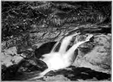
Fig. 37. Pothole in Bed of Stream, Ireland
Weathering of river beds. The erosion of stream beds is greatly helped by the work of the weather. Especially at low water more or less of the bed is exposed to the action of frost and heat and cold, joints are opened, rocks are pried loose and broken up and made ready to be swept away by the stream at time of flood.
Potholes. In rapids streams also drill out their rocky beds. Where some slight depression gives rise to an eddy, the pebbles which gather in it are whirled round and round, and, acting like the bit of an auger, bore out a cylindrical pit called a pothole. Potholes sometimes reach a depth of a score of feet. Where they are numerous they aid materially in deepening the channel, as the walls between them are worn away and they coalesce.
Waterfalls. One of the most effective means of erosion which the river possesses is the waterfall. The plunging water dislodges stones from the face of the ledge over which it pours, and often undermines it by excavating a deep pit at its base. Slice after slice is thus thrown down from the front of the cliff, and the cataract cuts its way upstream leaving a gorge behind it.
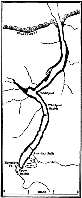
Fig. 38. Map of the Gorge of the Niagara River
Niagara Falls. The Niagara River flows from Lake Erie at Buffalo in a broad channel which it has cut but a few feet below the level of the region. Some thirteen miles from the outlet it plunges over a ledge one hundred and seventy feet high into the head of a narrow gorge which extends for seven miles to the escarpment of the upland in which the gorge is cut. The strata which compose the upland dip gently upstream and consist at top of a massive limestone, at the Falls about eighty feet thick, and below of soft and easily weathered shale. Beneath the Falls the underlying shale is cut and washed away by the descending water and retreats also because of weathering, while the overhanging limestone breaks down in huge blocks from time to time.
Niagara is divided by Goat Island into the Horseshoe Falls and the American Falls. The former is supplied by the main current of the river, and from the semicircular sweep of its rim a sheet of water in places at least fifteen or twenty feet deep plunges into a pool a little less than two hundred feet in depth. Here the force of the falling water is sufficient to move about the fallen blocks of limestone and use them in the excavation of the shale of the bed. At the American Falls the lesser branch of the river, which flows along the American side of Goat Island, pours over the side of the gorge and breaks upon a high talus of limestone blocks which its smaller volume of water is unable to grind to pieces and remove.
A series of surveys have determined that from 1842 to 1890 the Horseshoe Falls retreated at the rate of 2.18 feet per year, while the American Falls retreated at the rate of 0.64 feet in the same period. We cannot doubt that the same agency which is now lengthening the gorge at this rapid rate has cut it back its entire length of seven miles.
While Niagara Falls have been cutting back a gorge seven miles long and from two hundred to three hundred feet deep, the river above the Falls has eroded its bed scarcely below the level of the upland on which it flows. Like all streams which are the outlets of lakes, the Niagara flows out of Lake Erie clear of sediment, as from a settling basin, and carries no tools with which to abrade its bed. We may infer from this instance how slight is the erosive power of clear water on hard rock.

Fig. 39. Longitudinal Section of Niagara Gorge Black, water; F, falls; R, rapids; W, whirlpool; E, escarpment; N, north; S, south
Assuming that the rate of recession of the combined volumes of the American and Horseshoe Falls was three feet a year below Goat Island, and assuming that this rate has been uniform in the past, how long is it since the Niagara River fell over the edge of the escarpment where now is the mouth of the present gorge?
The profile of the bed of the Niagara along the gorge (Fig. 39) shows alternating deeps and shallows which cannot be accounted for, except in a single instance, by the relative hardness of the rocks of the river bed. The deeps do not exceed that at the foot of the Horseshoe Falls at the present time. When the gorge was being cut along the shallows, how did the Falls compare in excavating power, in force, and volume with the Niagara of to-day? How did the rate of recession at those times compare with the present rate? Is the assumption made above that the rate of recession has been uniform correct?
The first stretch of shallows below the Falls causes a tumultuous rapid impossible to sound. Its depth has been estimated at thirty- five feet. From what data could such an estimate be made?
Suggest a reason why the Horseshoe Falls are convex upstream.
At the present rate of recession which will reach the head of Goat Island the sooner, the American or the Horseshoe Falls? What will be the fate of the Falls left behind when the other has passed beyond the head of the island?
The rate at which a stream erodes its bed depends in part upon the nature of the rocks over which it flows. Will a stream deepen its channel more rapidly on massive or on thin-bedded and close- jointed rocks? on horizontal strata or on strata steeply inclined?
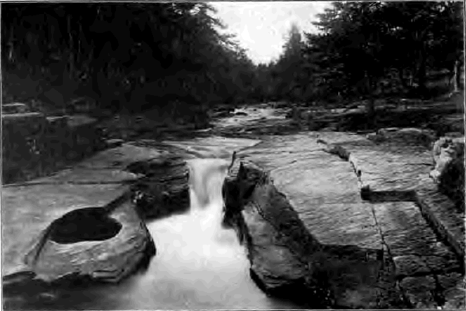
Fig. 40. A Stream in Scotland In what ways is the bed now being deepened?
Deposition
While the river carries its invisible load of dissolved rock on without stop to the sea, its load of visible waste is subject to many delays en route. Now and again it is laid aside, to be picked up later and carried some distance farther on its way. One of the most striking features of the river therefore is the waste accumulated along its course, in bars and islands in the channel, beneath its bed, and in flood plains along its banks. All this alluvium, to use a general term for river deposits, with which the valley is cumbered is really en route to the sea; it is only temporarily laid aside to resume its journey later on. Constantly the river is destroying and rebuilding its alluvial deposits, here cutting and there depositing along its banks, here eroding and there building a bar, here excavating its bed and there filling it up, and at all times carrying the material picked up at one point some distance on downstream before depositing it at another.
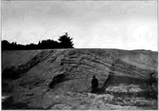
Fig. 41. Sand Bar deposited by Stream, showing Cross Bedding
These deposits are laid down by slackening currents where the velocity of the stream is checked, as on the inner side of curves, and where the slope of the bed is diminished, and in the lee of islands, bridge piers and projecting points of land. How slight is the check required to cause a current to drop a large part of its load may be inferred from the law of the relation of the transporting power to the velocity. If the velocity is decreased one half, the current can move fragments but one sixty-fourth the size of those which it could move before, and must drop all those of larger size.
Will a river deposit more at low water or at flood? when rising or when falling?
Stratification. River deposits are stratified, as may be seen in any fresh cut in banks or bars. The waste of which they are built has been sorted and deposited in layers, one above another; some of finer and some of coarser material. The sorting action of running water depends on the fact that its transporting power varies with the velocity. A current whose diminishing velocity compels it to drop coarse gravel, for example, is still able to move all the finer waste of its load, and separating it from the gravel, carries it on downstream; while at a later time slower currents may deposit on the gravel bed layers of sand, and, still later, slack water may leave on these a layer of mud. In case of materials lighter than water the transporting power does not depend on the velocity, and logs of wood, for instance, are floated on to the sea on the slowest as well as on the most rapid currents.

Fig. 42. Longitudinal Section of a River Bar
Cross bedding. A section of a bar exposed at low water may show that it is formed of layers of sand, or coarser stuff, inclined downstream as steeply often as the angle of repose of the material. From a boat anchored over the lower end of a submerged sand bar we may observe the way in which this structure, called cross bedding, is produced. Sand is continually pushed over the edge of the bar at b (Fig. 42) and comes to rest in successive layers on the sloping surface. At the same time the bar may be worn away at the upper end, a, and thus slowly advance down stream. While the deposit is thus cross bedded, it constitutes as a whole a stratum whose upper and lower surfaces are about horizontal. In sections of river banks one may often see a vertical succession of cross-bedded strata, each built in the way described.
Water wear. The coarser material of river deposits, such as cobblestones, gravel, and the larger grains of sand, are water worn, or rounded, except when near their source. Rolling along the bottom they have been worn round by impact and friction as they rubbed against one another and the rocky bed of the stream.
Experiments have shown that angular fragments of granite lose nearly half their weight and become well rounded after traveling fifteen miles in rotating cylinders partly filled with water. Marbles are cheaply made in Germany out of small limestone cubes set revolving in a current of water between a rotating bed of stone and a block of oak, the process requiring but about fifteen minutes. It has been found that in the upper reaches of mountain streams a descent of less than a mile is sufficient to round pebbles of granite.
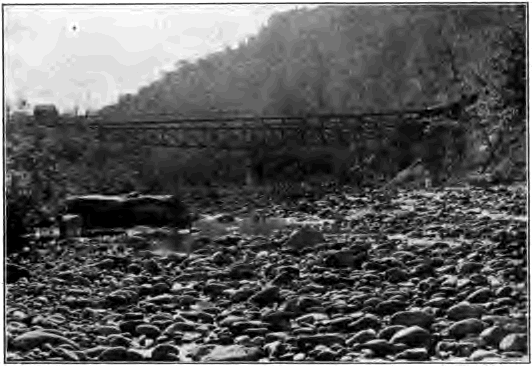
Fig. 43. Water-Worn Pebbles, Upper Potomac River, Maryland
Land Forms Due To River Erosion
River valleys. In their courses to the sea, rivers follow valleys of various forms, some shallow and some deep, some narrow and some wide. Since rivers are known to erode their beds and banks, it is a fair presumption that, aided by the weather, they have excavated the valleys in which they flow.
Moreover, a bird’s-eye view or a map of a region shows the significant fact that the valleys of a system unite with one another in a branch work, as twigs meet their stems and the branches of a tree its trunk. Each valley, from that of the smallest rivulet to that of the master stream, is proportionate to the size of the stream which occupies it. With a few explainable exceptions the valleys of tributaries join that of the trunk stream at a level; there is no sudden descent or break in the bed at the point of juncture. These are the natural consequences which must follow if the land has long been worked upon by streams, and no other process has ever been suggested which is competent to produce them. We must conclude that valley systems have been formed by the river systems which drain them, aided by the work of the weather; they are not gaping fissures in the earth’s crust, as early observers imagined, but are the furrows which running water has drawn upon the land.
As valleys are made by the slow wear of streams and the action of the weather, they pass in their development through successive stages, each of which has its own characteristic features. We may therefore classify rivers and valleys according to the stage which they have reached in their life history from infancy to old age.
Young River Valleys
Infancy. The Red River of the North. A region in northwestern Minnesota and the adjacent portions of North Dakota and Manitoba was so recently covered by the waters of an extinct lake, known as Lake Agassiz, that the surface remains much as it was left when the lake was drained away. The flat floor, spread smooth with lake-laid silts, is still a plain, to the eye as level as the sea. Across it the Red River of the North and its branches run in narrow, ditch-like channels, steep-sided and shallow, not exceeding sixty feet in depth, their gradients differing little from the general slopes of the region. The trunk streams have but few tributaries; the river system, like a sapling with few limbs, is still undeveloped. Along the banks of the trunk streams short gullies are slowly lengthening headwards, like growing twigs which are sometime to become large branches.
The flat interstream areas are as yet but little scored by drainage lines, and in wet weather water lingers in ponds in any initial depressions on the plain.
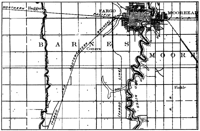
Fig. 44. A Young Lacustrine Plain; the Red River of the North Scale 5 inches = about 11 miles. Contour interval, 20 feet
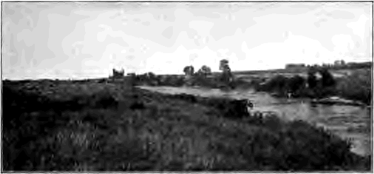
Fig. 45. A Young River, Iowa Note that it has hardly begun to cut in the plain of glacial drift on which it flows
Contours. In order to read the topographic maps of the text-book and the laboratory the student should know that contours are lines drawn on maps to represent relief, all points on any given contour being of equal height above sea level. The contour interval is the uniform vertical distance between two adjacent contours and varies on different maps. To express regions of faint relief a contour interval of ten or twenty feet is commonly selected; while in mountainous regions a contour interval of two hundred and fifty, five hundred, or even one thousand feet may be necessary in order that the contours may not be too crowded for easy reading.
Whether a river begins its life on a lake plain, as in the example just cited, or upon a coastal plain lifted from beneath the sea or on a spread of glacial drift left by the retreat of continental ice sheets, such as covers much of Canada and the northeastern parts of the United States, its infantile stage presents the same characteristic features,—a narrow and shallow valley, with undeveloped tributaries and undrained interstream areas. Ground water stands high, and, exuding in the undrained initial depressions, forms marshes and lakes.
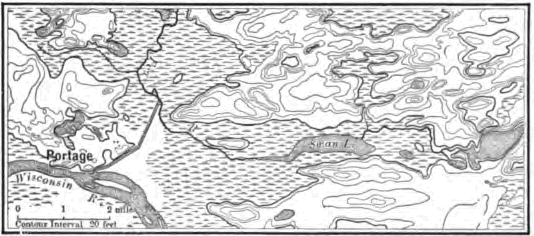
Fig. 46. A Young Drift Region in Wisconsin
Describe this area. How high are the hills? Are they such in form and position as would be left by stream erosion? Consult a map of the entire state and notice that the Fox River finds its way to Lake Michigan, while the Wisconsin empties into the Mississippi. Describe that portion of the divide here shown between the Mississippi and the St. Lawrence systems. Which is the larger river, the Wisconsin or the Fox? Other things being equal, which may be expected to deepen its bed the more rapidly? What changes are likely to occur when one of these rivers comes to flow at a lower level than the other? Why have not these changes occurred already?
Lakes. Lakes are perhaps the most obvious of these fleeting features of infancy. They are short-lived, for their destruction is soon accomplished by several means. As a river system advances toward maturity the deepening and extending valleys of the tributaries lower the ground-water surface and invade the undrained depressions of the region. Lakes having outlets are drained away as their basin rims are cut down by the outflowing streams,—a slow process where the rim is of hard rock, but a rapid one where it is of soft material such as glacial drift.
Lakes are effaced also by the filling of their basins. Inflowing streams and the wash of rains bring in waste. Waves abrade the shore and strew the débris worn from it over the lake bed. Shallow lakes are often filled with organic matter from decaying vegetation.
Does the outflowing stream, from a lake carry sediment? How does this fact affect its erosive power on hard rock? on loose material?
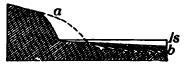
Fig. 47. A Small Lake being broadened and shoaled by Wave Wear ls, lake surface; dotted line, initial shore; b, fill made of material taken from a
Lake Geneva is a well-known example of a lake in process of obliteration. The inflowing Rhone has already displaced the waters of the lake for a length of twenty miles with the waste brought down from the high Alps. For this distance there extends up the Rhone Valley an alluvial plain, which has grown lakeward at the rate of a mile and a half since Roman times, as proved by the distance inland at which a Roman port now stands.
How rapidly a lake may be silted up under exceptionally favorable conditions is illustrated by the fact that over the bottom of the artificial lake, of thirty-five square miles, formed behind the great dam across the Colorado River at Austin, Texas, sediments thirty-nine feet deep gathered in seven years.
Lake Mendota, one of the many beautiful lakes of southern Wisconsin, is rapidly cutting back the soft glacial drift of its shores by means of the abrasion of its waves. While the shallow basin is thus broadened, it is also being filled with the waste; and the time is brought nearer when it will be so shoaled that vegetation can complete the work of its effacement.
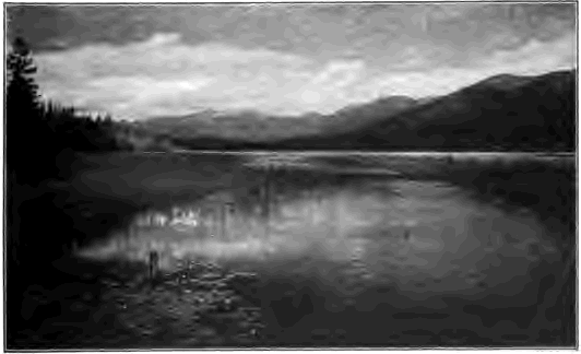
Fig. 48. A Lake well-nigh effaced, Montana By what means is the lake bed being filled?
Along the margin of a shallow lake mosses, water lilies, grasses, and other water-loving plants grow luxuriantly. As their decaying remains accumulate on the bottom, the ring of marsh broadens inwards, the lake narrows gradually to a small pond set in the midst of a wide bog, and finally disappears. All stages in this process of extinction may be seen among the countless lakelets which occupy sags in the recent sheets of glacial drift in the northern states; and more numerous than the lakes which still remain are those already thus filled with carbonaceous matter derived from the carbon dioxide of the atmosphere. Such fossil lakes are marked by swamps or level meadows underlain with muck.
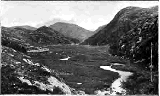
Fig. 49. A Level Meadow, Scotland Explain its origin. What will be its future?
The advance to maturity. The infantile stage is brief. As a river advances toward maturity the initial depressions, the lake basins of its area, are gradually effaced. By the furrowing action of the rain wash and the head ward lengthening, of tributaries a branchwork of drainage channels grows until it covers the entire area, and not an acre is left on which the fallen raindrop does not find already cut for it an uninterrupted downward path which leads it on by way of gully, brook, and river to the sea. The initial surface of the land, by whatever agency it was modeled, is now wholly destroyed; the region is all reduced to valley slopes.
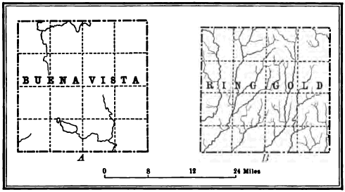
Fig. 50. Drainage Maps A, an area in its infancy, Buena Vista County, Iowa; B, an area in its maturity, Ringgold County, Iowa
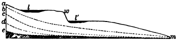
Fig. 51. Successive Longitudinal Profiles of a Stream am, initial profile, with waterfall at w, and basins at l and l´, which at first are occupied by lakes and later are filled or drained; b, c, d, and e, profiles established in succession as the stream advances from infancy toward old age. Note that these profiles are concave toward the sky. This is the erosion curve. What contrasting form has the weather weather curve (p. 34)?
The longitudinal profile of a stream. This at first corresponds with the initial surface of the region on which the stream begins to flow, although its way may lead through basins and down steep descents. The successive profiles to which it reduces its bed are illustrated in Figure 51. As the gradient, or rate of descent of its bed, is lowered, the velocity of the river is decreased until its lessening energy is wholly consumed in carrying its load and it can no longer erode its bed. The river is now at grade, and its capacity is just equal to its load. If now its load is increased the stream deposits, and thus builds up, or aggrades, its bed. On the other hand, if its load is diminished it has energy to spare, and resuming its work of erosion, degrades its bed. In either case the stream continues aggrading or degrading until a new gradient is found where the velocity is just sufficient to move the load, and here again it reaches grade.
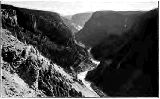
Fig. 52. A V-Valley,—the Canyon of the Yellowstone
Note the steep sides. What processes are at work upon them? How wide is the valley at the base compared with the width of the stream? Do you see any river deposits along the banks? Is the stream flowing swiftly over a rock bed, or quietly over a bed which it has built up? Is it graded or ungraded? Note that the canyon walls project in interlocking spurs
V-Valleys. Vigorous rivers well armed with waste make short work of cutting their beds to grade, and thus erode narrow, steep-sided gorges only wide enough at the base to accommodate the stream. The steepness of the valley slopes depends on the relative rates at which the bed is cut down by the stream and the sides are worn back by the weather. In resistant rock a swift, well-laden stream may saw out a gorge whose sides are nearly or even quite vertical, but as a rule young valleys whose streams have not yet reached grade are V-shaped; their sides flare at the top because here the rocks have longest been opened up to the action of the weather. Some of the deepest canyons may be found where a rising land mass, either mountain range or plateau, has long maintained by its continued uplift the rivers of the region above grade.
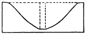
Fig. 53. Section of the Yellowstone Canyon This canyon is 100 feet deep, 2500 feet wide at the top, and about 250 feet wide at the bottom. Neglecting any cutting of the river against the banks, estimate what part of the excavation of the canyon is due to the vertical erosion of its bed by the river and what to weathering and rain wash on the canyon sides
In the northern hemisphere the north sides of river valleys are sometimes of more gentle slope than the south sides. Can you suggest a reason?
The Grand Canyon of the Colorado River in Arizona. The Colorado River trenches the high plateau of northern Arizona with a colossal canyon two hundred and eighteen miles long and more than a mile in greatest depth (Fig. 15). The rocks in which the canyon is cut are for the most part flat-lying, massive beds of limestones and sandstones, with some shales, beneath which in places harder crystalline rocks are disclosed. Where the canyon is deepest its walls have been profoundly dissected. Lateral ravines have widened into immense amphitheaters, leaving between them long ridges of mountain height, buttressed and rebuttressed with flanking spurs and carved into majestic architectural forms. From the extremity of one of these promontories it is two miles or more across the gulf to the point of the one opposite, and the heads of the amphitheaters are thirteen miles apart.
The lower portion of the canyon is much narrower (Fig. 54) and its walls of dark crystalline rock sink steeply to the edge of the river, a swift, powerful stream a few hundred feet wide, turbid with reddish silt, by means of which it continually rasps its rocky bed as it hurries on. The Colorado is still deepening its gorge. In the Grand Canyon its gradient is seven and one half feet to the mile, but, as in all ungraded rivers, the descent is far from uniform. Graded reaches in soft rock alternate with steeper declivities in hard rock, forming rapids such as, for example, a stretch of ten miles where the fall averages twenty-one feet to the mile. Because of these dangerous rapids the few exploring parties who have traversed the Colorado canyon have done so at the hazard of their lives.
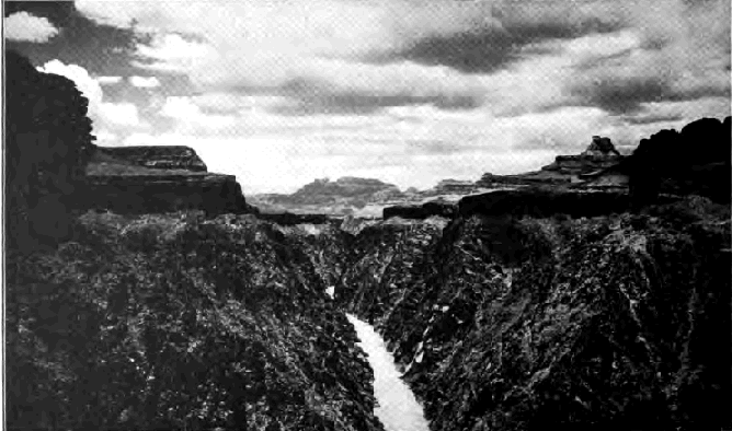
Fig. 54. Grand Canyon of the Colorado River, Arizona
The canyon has been shaped by several agencies. Its depth is due to the river which has sawed its way far toward the base of a lofty rising plateau. Acting alone this would have produced a slitlike gorge little wider than the breadth of the stream. The impressive width of the canyon and the magnificent architectural masses which fill it are owing to two causes. Running water has gulched the walls and weathering has everywhere attacked and driven them back. The horizontal harder beds stand out in long lines of vertical cliffs, often hundreds of feet in height, at whose feet talus slopes conceal the outcrop of the weaker strata (Fig. 15). As the upper cliffs have been sapped and driven back by the weather, broad platforms are left at their bases and the sides of the canyon descend to the river by gigantic steps. Far up and down the canyon the eye traces these horizontal layers, like the flutings of an elaborate molding, distinguishing each by its contour as well as by its color and thickness.

Fig. 55. Diagrams illustrating Conditions which produce Falls or Rapids
A, vertical succession of harder and softer rocks; B, horizontal succession of the same. In A the stream ab in sinking its bed through a mass of strata of different degrees of hardness has discovered the weak layer s beneath the hard layer h. It rapidly cuts its way in s, while in h its work is delayed. Thus the profile afb´ is soon reached, with falls at f. In B the initial profile is shown by dotted line.
The Grand Canyon of the Colorado is often and rightly cited as an example of the stupendous erosion which may be accomplished by a river. And yet the Colorado is a young stream and its work is no more than well begun. It has not yet wholly reached grade, and the great task of the river and its tributaries—the task of leveling the lofty plateau to a low plain and of transporting it grain by grain to the sea—still lies almost entirely in the future.
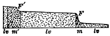
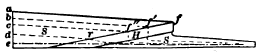
Fig. 56. Longitudinal Section of Yellowstone River at Lower Fall, F, and Upper Fall, F´, Yellowstone National Park la, lava deeply decayed through action of thermal waters; m and m´, masses of decayed lavas to whose hardness the falls are due. Which fall will be worn away the sooner? How far upstream will each fall migrate? Draw profile of the river when one fall has disappeared Fig. 57. Diagram illustrating Migration of a Fall due to a Hard Layer H, in the Midst of Soft Layers S and S, all dipping upstream a, b, c, d, and e, successive positions of the fall; r, rapid to which the fall is reduced. Draw diagram showing migration of fall in strata dipping downstream. Under what conditions of inclination of the strata will a fall migrate the farthest and have the longest life? Under what conditions will it migrate the least distance and soonest be destroyed?
Waterfalls and rapids. Before the bed of a stream is reduced to grade it may be broken by abrupt descents which give rise to waterfalls and rapids. Such breaks in a river’s bed may belong to the initial surface over which it began its course; still more commonly are they developed in the rock mass through which it is cutting its valley. Thus, wherever a stream leaves harder rocks to flow over softer ones the latter are quickly worn below the level of the former, and a sharp change in slope, with a waterfall or rapid, results (Fig. 55).
At time of flood young tributaries with steeper courses than that of the trunk stream may bring down stones and finer waste, which the gentler current cannot move along, and throw them as a dam across its way. The rapids thus formed are also ephemeral, for as the gradient of the tributaries is lowered the main stream becomes able to handle the smaller and finer load which they discharge.
A rare class of falls is produced where the minor tributaries of a young river are not able to keep pace with their master stream in the erosion of their beds because of their smaller volume, and thus join it by plunging over the side of its gorge. But as the river approaches grade and slackens its down cutting, the tributaries sooner or later overtake it, and effacing their falls, unite with it on a level.
Click on image to view larger version.
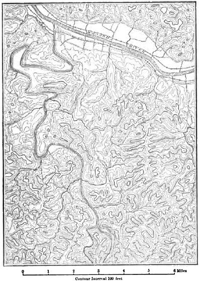
Fig. 58. Maturely Dissected Plateau near Charleston, West Virginia
Compare the number of streams in any given number of square miles with the number on an area of the same size in the Red River Valley (Fig. 44). What is the shape of the ridges? Are their summits broad or narrow? Are their crests even or broken by knobs and cols (the depressions on the crest line)? If the latter, how deeply have the cols been worn beneath the summits of the knobs?
Waterfalls and rapids of all kinds are evanescent features of a river’s youth. Like lakes they are soon destroyed, and if any long time had already elapsed since their formation they would have been obliterated already.
Local baselevels. That balanced condition called grade, where a river neither degrades its bed by erosion nor aggrades it by deposition, is first attained along reaches of soft rocks, ungraded outcrops of hard rocks remaining as barriers which give rise to rapids or falls. Until these barriers are worn away they constitute local baselevels, below which level the stream, up valley from them, cannot cut. They are eroded to grade one after another, beginning with the least strong, or the one nearest the mouth of the stream. In a similar way the surface of a lake in a river’s course constitutes for all inflowing streams a local baselevel, which disappears when the basin is filled or drained.
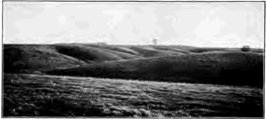
Fig. 59. A Maturity Dissected Region of Slight Relief, Iowa
Mature And Old Rivers
Maturity is the stage of a river’s complete development and most effective work. The river system now has well under way its great task of wearing down the land mass which it drains and carrying it particle by particle to the sea. The relief of the land is now at its greatest; for the main channels have been sunk to grade, while the divides remain but little worn below their initial altitudes. Ground water now stands low. The run-off washes directly to the streams, with the least delay and loss by evaporation in ponds and marches; the discharge of the river is therefore at its height. The entire region is dissected by stream ways. The area of valley slopes is now largest and sheds to the streams a heavier load of waste than ever before. At maturity the river system is doing its greatest amount of work both in erosion and in the carriage of water and of waste to the sea.
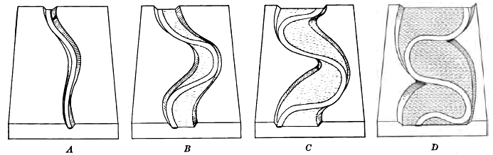
Fig. 60. Successive Stages, A, B, C, and D, in Valley-Widening by Planation
Describe valley A. What changes have taken place in B, C, and D? Do the river bends remain stationary or move up or down valley? With what effect on the projecting spurs of the valley sides? Draw diagrams showing a still later stage than D
Lateral erosion. On reaching grade a river ceases to scour its bed, and it does not again begin to do so until some change in load or volume enables it to find grade at a lower level. On the other hand, a stream erodes its banks at all stages in its history, and with graded rivers this process, called lateral erosion, or planation, is specially important. The current of a stream follows the outer side of all curves or bends in the channel, and on this side it excavates its bed the deepest and continually wears and saps its banks. On the inner side deposition takes place in the more shallow and slower-moving water. The inner bank of bends is thus built out while the outer bank is worn away. By swinging its curves against the valley sides a graded river continually cuts a wider and wider floor. The V-valley of youth is thus changed by planation to a flat-floored valley with flaring sides which gradually become subdued by the weather to gentle slopes. While widening their valleys streams maintain a constant width of channel, so that a wide-floored valley does not signify that it ever was occupied by a river of equal width.
The gradient. The gradients of graded rivers differ widely. A large river with a light load reaches grade on a faint slope, while a smaller stream heavily burdened with waste requires a steep slope to give it velocity sufficient to move the load.
The Platte, a graded river of Nebraska with its headwaters in the Rocky Mountains, is enfeebled by the semi-arid climate of the Great Plains and surcharged with the waste brought down both by its branches in the mountains and by those whose tracks lie over the soft rocks of the plains. It is compelled to maintain a gradient of eight feet to the mile in western Nebraska. The Ohio reaches grade with a slope of less than four inches to the mile from Cincinnati to its mouth, and the powerful Mississippi washes along its load with a fall of but three inches per mile from Cairo to the Gulf.
Other things being equal, which of graded streams will have the steeper gradient, a trunk stream or its tributaries? a stream supplied with gravel or one with silt?
Other factors remaining the same, what changes would occur if the Platte should increase in volume? What changes would occur if the load should be increased in amount or in coarseness?

Fig. 61. Successive Cross Sections of a Region as it advances from Infancy a, to Old Age e
The old age of rivers. As rivers pass their prime, as denudation lowers the relief of the region, less waste and finer is washed over the gentler slopes of the lowering hills. With smaller loads to carry, the rivers now deepen their valleys and find grade with fainter declivities nearer the level of the sea. This limit of the level of the sea beneath which they cannot erode is known as baselevel. [1] As streams grow old they approach more and more closely to baselevel, although they are never able to attain it. Some slight slope is needed that water may flow and waste be transported over the land. Meanwhile the relief of the land has ever lessened. The master streams and their main tributaries now wander with sluggish currents over the broad valley floors which they have planed away; while under the erosion of their innumerable branches and the wear of the weather the divides everywhere are lowered and subdued to more and more gentle slopes. Mountains and high plateaus are thus reduced to rolling hills, and at last to plains, surmounted only by such hills as may still be unreduced to the common level, because of the harder rocks of which they are composed or because of their distance from the main erosion channels. Such regions of faint relief, worn down to near base level by subaërial agencies, are known as peneplains (almost plains). Any residual masses which rise above them are called monadnocks, from the name of a conical peak of New Hampshire which overlooks the now uplifted peneplain of southern New England.
In its old age a region becomes mantled with thick sheets of fine and weathered waste, slowly moving over the faint slopes toward the water ways and unbroken by ledges of bare rock. In other words, the waste mantle also is now graded, and as waterfalls have been effaced in the river beds, so now any ledges in the wide streams of waste are worn away and covered beneath smooth slopes of fine soil. Ground water stands high and may exude in areas of swamp. In youth the land mass was roughhewn and cut deep by stream erosion. In old age the faint reliefs of the land dissolve away, chiefly under the action of the weather, beneath their cloak of waste.
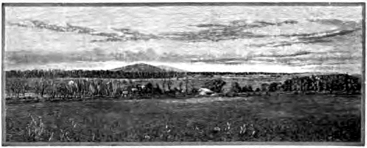
Fig. 62. Peneplain surrounded by Monadnocks, Piedmont Belt, Virginia From Davis’ Elementary Physical Geography
The cycle of erosion. The successive stages through which a land mass passes while it is being leveled to the sea constitute together a cycle of erosion. Each stage of the cycle from infancy to old age leaves, as we have seen, its characteristic records in the forms sculptured on the land, such as the shapes of valleys and the contours of hills and plains. The geologist is thus able to determine by the land forms of any region the stage in the erosion cycle to which it now belongs, and knowing what are the earlier stages of the cycle, to read something of the geological history of the region.
Interrupted cycles. So long a time is needed to reduce a land mass to baselevel that the process is seldom if ever completed during a single uninterrupted cycle of erosion. Of all the various interruptions which may occur the most important are gradual movements of the earth’s crust, by which a region is either depressed or elevated relative to sea level.
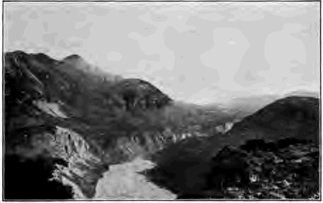
Fig. 63. Young Inner Gorge in Wide Older Valley, Alaska
The depression of a region hastens its old age by decreasing the gradient of streams, by destroying their power to excavate their beds and carry their loads to a degree corresponding to the amount of the depression, and by lessening the amount of work they have to do. The slackened river currents deposit their waste in Hood plains which increase in height as the subsidence continues. The lower courses of the rivers are invaded by the sea and become estuaries, while the lower tributaries are cut off from the trunk stream.
Elevation, on the other hand, increases the activity of all agencies of weathering, erosion, and transportation, restores the region to its youth, and inaugurates a new cycle of erosion. Streams are given a steeper gradient, greater velocity, and increased energy to carry their loads and wear their beds. They cut through the alluvium of their flood plains, leaving it on either bank as successive terraces, and intrench themselves in the underlying rock. In their older and wider valleys they cut narrow, steep-walled inner gorges, in which they flow swiftly over rocky floors, broken here and there by falls and rapids where a harder layer of rock has been discovered. Winding streams on plains may thus incise their meanders in solid rock as the plains are gradually uplifted. Streams which are thus restored to their youth are said to be revived.
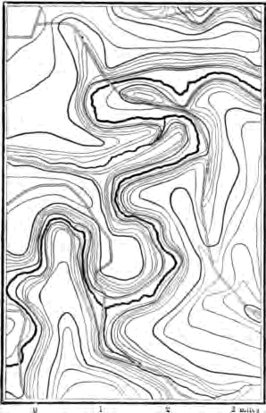
Fig. 64. Incised Meanders of Oneota River, Iowa
As streams cut deeper and the valley slopes are steepened, the mantle of waste of the region undergoing elevation is set in more rapid movement. It is now removed particle by particle faster than it forms. As the waste mantle thins, weathering attacks the rocks of the region more energetically until an equilibrium is reached again; the rocks waste rapidly and their waste is as rapidly removed.
Dissected peneplains. When a rise of the land brings one cycle to an end and begins another, the characteristic land forms of each cycle are found together and the topography of the region is composite until the second cycle is so far advanced that the land forms of the first cycle are entirely destroyed. The contrast between the land surfaces of the later and the earlier cycles is most striking when the earlier had advanced to age and the later is still in youth. Thus many peneplains which have been elevated and dissected have been recognized by the remnants of their ancient erosion surfaces, and the length of time which has elapsed since their uplift has been measured by the stage to which the new cycle has advanced.
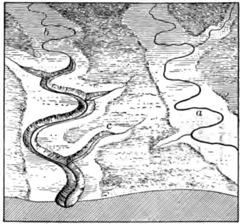
Fig. 65.
Describe the valley of stream a. Is it young or old? How does the valley of b differ from that of a? Compare as to form and age the inner valley of b with the outer valley and with the valley of a. Account for the inner valley. Why does it not extend to the upper portion of the course of b? Will it ever do so? Draw longitudinal profile of b, showing the different gradient of upper and lower portions of its course not here seen. As the inner valley of tributary c extends headward it may invade the valley of a before the inner valley of a has worked upstream to the area seen in the diagram. With what results?
The piedmont belt. As an example of an ancient peneplain uplifted and dissected we may cite the Piedmont Belt, a broad upland lying between the Appalachian Mountains and the Atlantic coastal plain. The surface of the Piedmont is gently rolling. The divides, which are often smooth areas of considerable width, rise to a common plane, and from them one sees in every direction an even sky line except where in places some lone hill or ridge may lift itself above the general level (Fig. 62). The surface is an ancient one, for the mantle of residual waste lies deep upon it, soils are reddened by long oxidation, and the rocks are rotted to a depth of scores of feet.
At present, however, the waste mantle is not forming so rapidly as it is being removed. The streams of the upland are actively engaged in its destruction. They flow swiftly in narrow, rock- walled valleys over rocky beds. This contrast between the young streams and the aged surface which they are now so vigorously dissecting can only be explained by the theory that the region once stood lower than at present and has recently been upraised. If now we imagine the valleys refilled with the waste which the streams have swept away, and the upland lowered, we restore the Piedmont region to the condition in which it stood before its uplift and dissection,—a gently rolling plain, surmounted here and there by isolated hills and ridges.
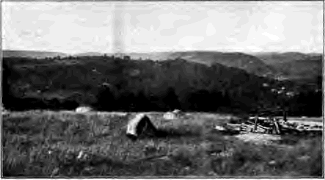
Fig. 66. Dissected Peneplain of Southern New England
The surface of the ancient Piedmont plain, as it may be restored from the remnants of it found on the divides, is not in accordance with the structures of the country rocks. Where these are exposed to view they are seen to be far from horizontal. On the walls of river gorges they dip steeply and in various directions and the streams flow over their upturned edges. As shown in Figure 67, the rocks of the Piedmont have been folded and broken and tilted.

Fig. 67. Section in Piedmont Belt M, a monadnock
It is not reasonable to believe that when the rocks of the Piedmont were thus folded and otherwise deformed the surface of the region was a plain. The upturned layers have not always stopped abruptly at the even surface of the Piedmont plain which now cuts across them. They are the bases of great folds and tilted blocks which must once have risen high in air. The complex and disorderly structures of the Piedmont rocks are those seen in great mountain ranges, and there is every reason to believe that these rocks after their deformation rose to mountain height.
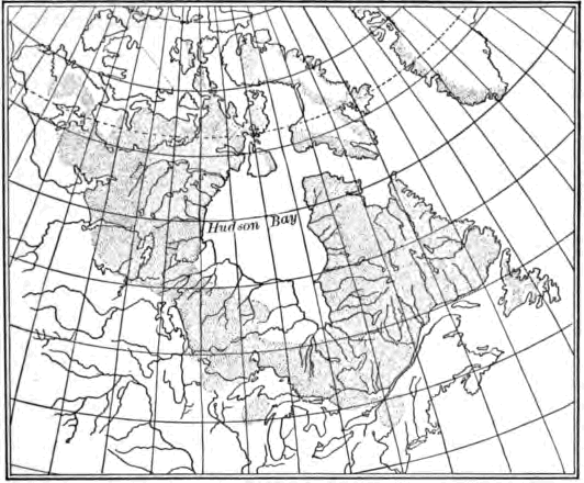
Fig. 68. The area of the Laurentian Peneplain (shaded)
The ancient Piedmont plain cuts across these upturned rocks as independently of their structure as the even surface of the sawed stump of some great tree is independent of the direction of its fibers. Hence the Piedmont plain as it was before its uplift was not a coastal plain formed of strata spread in horizontal sheets beneath the sea and then uplifted; nor was it a structural plain, due to the resistance to erosion of some hard, flat-lying layer of rock. Even surfaces developed on rocks of discordant structure, such as the Piedmont shows, are produced by long denudation, and we may consider the Piedmont as a peneplain formed by the wearing down of mountain ranges, and recently uplifted.
The Laurentian peneplain. This is the name given to a denuded surface on very ancient rocks which extends from the Arctic Ocean to the St. Lawrence River and Lake Superior, with small areas also in northern Wisconsin and New York. Throughout this U-shaped area, which incloses Hudson Bay within its arms, the country rocks have the complicated and contorted structures which characterize mountain ranges (see Fig. 179, P. 211). But the surface of the area is by no means mountainous. The sky line when viewed from the divides is unbroken by mountain peaks or rugged hills. The surface of the arm west of Hudson Bay is gently undulating and that of the eastern arm has been roughened to low-rolling hills and dissected in places by such deep river gorges as those of the Ottawa and Saguenay. This immense area may be regarded as an ancient peneplain truncating the bases of long-vanished mountains and dissected after elevation.
In the examples cited the uplift has been a broad one and to comparatively little height. Where peneplains have been uplifted to great height and have since been well dissected, and where they have been upfolded and broken and uptilted, their recognition becomes more difficult. Yet recent observers have found evidences of ancient lowland surfaces of erosion on the summits of the Allegheny ridges, the Cascade Mountains (Fig. 69), and the western slope of the Sierra Nevadas.
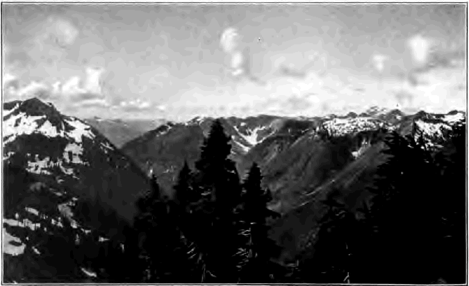
Fig. 69. View in the Cascade Mountains, Washington The general level to which these ridges rise may be accounted for by the uplift and dissection of a once low-lying peneplain
The southern Appalachian region. We have here an example of an area the latter part of whose geological history may be deciphered by means of its land forms. The generalized section of Figure 70, which passes from west to east across a portion of the region in eastern Tennessee, shows on the west a part of the broad Cumberland plateau. On the east is a roughened upland platform, from which rise in the distance the peaks of the Great Smoky Mountains. The plateau, consisting of strata but little changed from their original flat-lying attitude, and the platform, developed on rocks of disordered structure made crystalline by heat and pressure, both stand at the common level of the line AB. They are separated by the Appalachian valley, forty miles wide, cut in strata which have been folded and broken into long narrow blocks. The valley is traversed lengthwise by long, low ridges, the outcropping edges of the harder strata, which rise to about the same level,—that of the line cd. Between these ridges stretch valley lowlands at the level ef excavated in the weaker rocks, while somewhat below them lie the channels of the present streams now busily engaged in deepening their beds.
The valley lowlands. Were they planed by graded or ungraded streams? Have the present streams reached grade? Why did the streams cease widening the floors of the valley lowlands? How long since? When will they begin anew the work of lateral planation? What effect will this have on the ridges if the present cycle of erosion continues long uninterrupted?

Fig. 70. Generalized Section of the Southern Appalachian Region in Eastern Tennessee
The ridges of the Appalachian valley. Why do they stand above the valley lowlands? Why do their summits lie in about the same plane? Refilling the valleys intervening between these ridges with the material removed by the streams, what is the nature of the surface thus restored? Does this surface cd accord with the rock structures on which it has been developed? How may it have been made? At what height did the land stand then, compared with its present height? What elevations stood above the surface cd? Why? What name may you use to designate them? How does the length of time needed to develop the surface cd compare with that needed to develop the valley lowlands?
The platform and plateau. Why do they stand at a common level ab? Of what surface may they be remnants? Is it accordant with the rock structure? How was it produced? What unconsumed masses overlooked it? Did the rocks of the Appalachian valley stand above this surface when it was produced? Did they then stand below it? Compare the time needed to develop this surface with that needed to develop cd. Which surface is the older?
How many cycles of erosion are represented here? Give the erosion history of the region by cycles, beginning with the oldest, the work done in each and the work left undone, what brought each cycle to a close, and how long relatively it continued.
CHAPTER IV
RIVER DEPOSITS
The characteristic features of river deposits and the forms which they assume may be treated under three heads: (1) valley deposits, (2) basin deposits, and (3) deltas.
Valley Deposits
Flood plains. The deposits which streams build along their courses at times of flood are known as flood plains. A swift current then sweeps along the channel, while a shallow sheet of water moves slowly over the flood plain, spreading upon it a thin layer of sediment. It has been estimated that each inundation of the Nile leaves a layer of fertilizing silt three hundredths of an inch thick over the flood plain of Egypt.
Flood plains may consist of a thin spread of alluvium over the flat rock floor of a valley which is being widened by the lateral erosion of a graded stream (Fig. 60). Flood-plain deposits of great thickness may be built by aggrading rivers even in valleys whose rock floors have never been thus widened (Fig. 368).
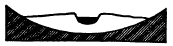
Fig. 71. Cross Section of a Flood Plain
A cross section of a flood plain (Fig. 71) shows that it is highest next the river, sloping gradually thence to the valley sides. These wide natural embankments are due to the fact that the river deposit is heavier near the bank, where the velocity of the silt-laden channel current is first checked by contact with the slower-moving overflow.
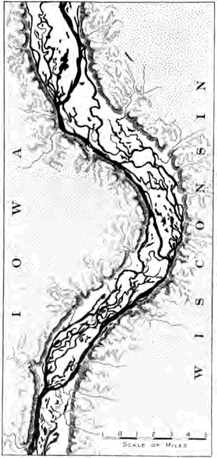
Fig. 72. Waste-filled Valley and Braided Channels of the Upper Mississippi
Thus banked off from the stream, the outer portions of a flood plain are often ill-drained and swampy, and here vegetal deposits, such as peat, may be interbedded with river silts.
A map of a wide flood plain, such as that of the Mississippi or the Missouri (Fig. 77), shows that the courses of the tributaries on entering it are deflected downstream. Why?
The aggrading streams by which flood plains are constructed gradually build their immediate banks and beds to higher and higher levels, and therefore find it easy at times of great floods to break their natural embankments and take new courses over the plain. In this way they aggrade each portion of it in turn by means of their shifting channels.
Braided channels. A river actively engaged in aggrading its valley with coarse waste builds a flood plain of comparatively steep gradient and often flows down it in a fairly direct course and through a network of braided channels. From time to time a channel becomes choked with waste, and the water no longer finding room in it breaks out and cuts and builds itself a new way which reunites down valley with the other channels. Thus there becomes established a network of ever-changing channels inclosing low islands of sand and gravel.
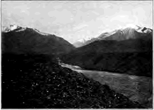
Fig. 73. Terraced Valley of River in Central Asia
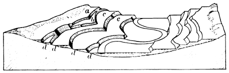
Fig. 74. Terraces carved in Alluvial Deposits Which is older, the rock floor of the valley or the river deposits which fill it? What are the relative ages of terraces a, b, c, and e? It will be noted that the remnants of the higher flood plains have not been swept away by the meandering river, as it swung from side to side of the valley at lower levels, because they have been defended by ledges of hard rock in the projecting spurs of the initial valley. The stream has encountered such defending ledges at the point marked d
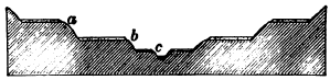
Fig. 75. River Terraces of Rock covered with Alluvium c, recent flood plain of the river. To what processes is it due? Account for the alluvium at a and b and on the opposite side of the valley at the same levels. Which is the older? Account for the flat rock floors on which these deposits of alluvium rest. Give the entire history which may be read in the section
Terraces. While aggrading streams thus tend to shift their channels, degrading streams, on the contrary, become more and more deeply intrenched in their valleys. It often occurs that a stream, after having built a flood plain, ceases to aggrade its bed because of a lessened load or for other reasons, such as an uplift of the region, and begins instead to degrade it. It leaves the original flood plain out of reach of even the highest floods. When again it reaches grade at a lower level it produces a new flood plain by lateral erosion in the older deposits, remnants of which stand as terraces on one or both sides of the valley. In this way a valley may be lined with a succession of terraces at different levels, each level representing an abandoned flood plain.
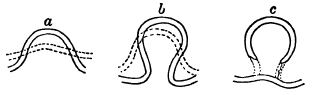
Fig. 76. Development of a Meander The dotted line in a, b, and c shows the stage preceding that indicated by the unbroken line
Meanders. Valleys aggraded with fine waste form well-nigh level plains over which streams wind from side to side of a direct course in symmetric bends known as meanders, from the name of a winding river of Asia Minor. The giant Mississippi has developed meanders with a radius of one and one half miles, but a little creek may display on its meadow as perfect curves only a rod or so in radius. On the flood plain of either river or creek we may find examples of the successive stages in the development of the meander, from its beginning in the slight initial bend sufficient to deflect the current against the outer side. Eroding here and depositing on the inner side of the bend, it gradually reaches first the open bend (Fig. 76, a) whose width and length are not far from equal, and later that of the horseshoe meander (Fig. 76, b) whose diameter transverse to the course of the stream is much greater than that parallel with it. Little by little the neck of land projecting into the bend is narrowed, until at last it is cut through and a “cut-off” is established. The old channel is now silted up at both ends and becomes a crescentic lagoon (Fig. 76, c), or oxbow lake, which fills gradually to an arc-shaped shallow depression.
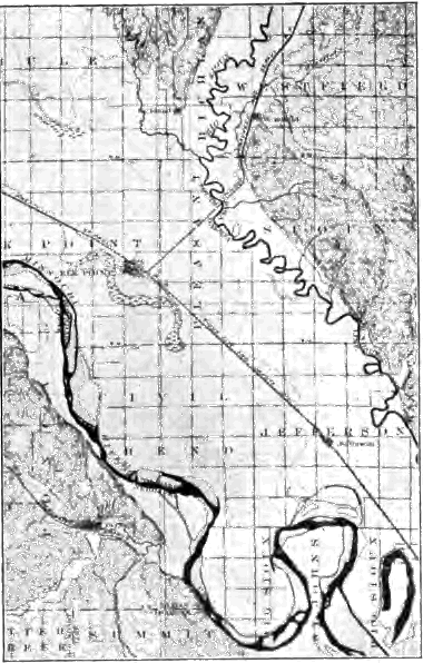
Fig. 77. Map of a portion of the Flood Plain of the Missouri River Each small square represents one square mile. How wide is the flood plain of the Missouri? How wide is the flood plain of the Big Sioux? Why is the latter river deflected down valley on entering the flood plain of the master stream? How do the meanders of the two rivers compare in size? How does the width of each flood plain compare with the width of the belt occupied by the meanders of the river? Do you find traces of any former channels?
Flood plains characteristic of mature rivers. On reaching grade a stream planes a flat floor for its continually widening valley. Ever cutting on the outer bank of its curves, it deposits on the inner bank scroll-like flood-plain patches (Fig 60). For a while the valley bluffs do not give its growing meanders room to develop to their normal size, but as planation goes on, the bluffs are driven back to the full width of the meander belt and still later to a width which gives room for broad stretches of flood plain on either side (Fig. 77).
Usually a river first attains grade near its mouth, and here first sinks its bed to near baselevel. Extending its graded course upstream by cutting away barrier after barrier, it comes to have a widened and mature valley over its lower course, while its young headwaters are still busily eroding their beds. Its ungraded branches may thus bring down to its lower course more waste than it is competent to carry on to the sea, and here it aggrades its bed and builds a flood plain in order to gain a steeper gradient and velocity enough to transport its load.
As maturity is past and the relief of the land is lessened, a smaller and smaller load of waste is delivered to the river. It now has energy to spare and again degrades its valley, excavating its former flood plains and leaving them in terraces on either side, and at last in its old age sweeping them away.
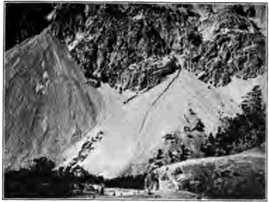
Fig. 78. Alluvial Cones, Wyoming
Alluvial cones and fans. In hilly and mountainous countries one often sees on a valley side a conical or fan-shaped deposit of waste at the mouth of a lateral stream. The cause is obvious: the young branch has not been able as yet to wear its bed to accordant level with the already deepened valley of the master stream. It therefore builds its bed to grade at the point of juncture by depositing here its load of waste,—a load too heavy to be carried along the more gentle profile of the trunk valley.
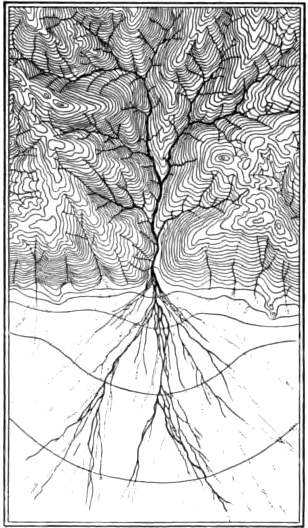
Fig. 79. Tributaries and Distributaries of a Fan-Building Stream
Where rivers descend from a mountainous region upon the plain they may build alluvial fans of exceedingly gentle slope. Thus the rivers of the western side of the Sierra Nevada Mountains have spread fans with a radius of as much as forty miles and a slope too slight to be detected without instruments, where they leave the rock-cut canyons in the mountains and descend upon the broad central valley of California.
As a river flows over its fan it commonly divides into a branchwork of shifting channels called distributaries, since they lead off the water from the main stream. In this way each part of the fan is aggraded and its symmetric form is preserved.
Piedmont plains. Mountain streams may build their confluent fans into widespread piedmont (foot of the mountain) alluvial plains. These are especially characteristic of arid lands, where the streams wither as they flow out upon the thirsty lowlands and are therefore compelled to lay down a large portion of their load. In humid climates mountain-born streams are usually competent to carry their loads of waste on to the sea, and have energy to spare to cut the lower mountain slopes into foothills. In arid regions foothills are commonly absent and the ranges rise, as from pedestals, above broad, sloping plains of stream-laid waste.

Fig. 80. Section from the Rocky Mountains Eastward River deposits dotted
The High Plains. The rivers which flow eastward from the Rocky Mountains have united their fans in a continuous sheet of waste which stretches forward from the base of the mountains for hundreds of miles and in places is five hundred feet thick (Fig. 80). That the deposit was made in ancient times on land and not in the sea is proved by the remains which it contains of land animals and plants of species now extinct. That it was laid by rivers and not by fresh-water lakes is shown by its structure. Wide stretches of flat-lying, clays and sands are interrupted by long, narrow belts of gravel which mark the channels of the ancient streams. Gravels, and sands are often cross bedded, and their well worn pebbles may be identified with the rocks of the mountains. After building this sheet of waste the streams ceased to aggrade and began the work of destruction. Large uneroded remnants, their surfaces flat as a floor, remain as the High Plains of western Kansas and Nebraska.
River deposits in subsiding troughs. To a geologist the most important river deposits are those which gather in areas of gradual subsidence; they are often of vast extent and immense thickness, and such deposits of past geological ages have not infrequently been preserved, with all their records of the times in which they were built, by being carried below the level of the sea, to be brought to light by a later uplift. On the other hand, river deposits which remain above baselevels of erosion are swept away comparatively soon.
The Great Valley Of California is a monotonously level plain of great fertility, four hundred miles in length and fifty miles in average width, built of waste swept down by streams from the mountain ranges which inclose it,—the Sierra Nevada on the east and the Coast Range on the west. On the waste slopes at the foot of the bordering hills coarse gravels and even bowlders are left, while over the interior the slow-flowing streams at times of flood spread wide sheets of silt. Organic deposits are now forming by the decay of vegetation in swampy tule (reed) lands and in shallow lakes which occupy depressions left by the aggrading streams.
Deep borings show that this great trough is filled to a depth of at least two thousand feet below sea level with recent unconsolidated sands and silts containing logs of wood and fresh- water shells. These are land deposits, and the absence of any marine deposits among them proves that the region has not been invaded by the sea since the accumulation began. It has therefore been slowly subsiding and its streams, although continually carried below grade, have yet been able to aggrade the surface as rapidly as the region sank, and have maintained it, as at present, slightly above sea level.
The Indo-Gangetic Plain, spread by the Brahmaputra, the Ganges, and the Indus river systems, stretches for sixteen hundred miles along the southern base of the Himalaya Mountains and occupies an area of three hundred thousand square miles (Fig. 342). It consists of the flood plains of the master streams and the confluent fans of the tributaries which issue from the mountains on the north. Large areas are subject to overflow each season of flood, and still larger tracts mark abandoned flood plains below which the rivers have now cut their beds. The plain is built of far- stretching beds of clay, penetrated by streaks of sand, and also of gravel near the mountains. Beds of impure peat occur in it, and it contains fresh-water shells and the bones of land animals of species now living in northern India. At Lucknow an artesian well was sunk to one thousand feet below sea level without reaching the bottom of these river-laid sands and silts, proving a slow subsidence with which the aggrading rivers have kept pace.
Warped valleys. It is not necessary that an area should sink below sea level in order to be filled with stream-swept waste. High valleys among growing mountain ranges may suffer warping, or may be blockaded by rising mountain folds athwart them. Where the deformation is rapid enough, the river may be ponded and the valley filled with lake-laid sediments. Even when the river is able to maintain its right of way it may yet have its declivity so lessened that it is compelled to aggrade its course continually, filling the valley with river deposits which may grow to an enormous thickness.
Behind the outer ranges of the Himalaya Mountains lie several waste-filled valleys, the largest of which are Kashmir and Nepal, the former being an alluvial plain about as large as the state of Delaware. The rivers which drain these plains have already cut down their outlet gorges sufficiently to begin the task of the removal of the broad accumulations which they have brought in from the surrounding mountains. Their present flood plains lie as much as some hundreds of feet below wide alluvial terraces which mark their former levels. Indeed, the horizontal beds of the Hundes Valley have been trenched to the depth of nearly three thousand feet by the Sutlej River. These deposits are recent or subrecent, for there have been found at various levels the remains of land plants and land and fresh-water shells, and in some the bones of such animals as the hyena and the goat, of species or of genera now living. Such soft deposits cannot be expected to endure through any considerable length of future time the rapid erosion to which their great height above the level of the sea will subject them.

Fig. 81. Cross Section of Aggraded Valley, showing Structure of River Deposits
Characteristics of river deposits. The examples just cited teach clearly the characteristic features of extensive river deposits. These deposits consist of broad, flat-lying sheets of clay and fine sand left by the overflow at time of flood, and traversed here and there by long, narrow strips of coarse, cross-bedded sands and gravels thrown down by the swifter currents of the shifting channels. Occasional beds of muck mark the sites of shallow lakelets or fresh-water swamps. The various strata also contain some remains of the countless myriads of animals and plants which live upon the surface of the plain as it is in process of building. River shells such as the mussel, land shells such as those of snails, the bones of fishes and of such land animals as suffer drowning at times of flood or are mired in swampy places, logs of wood, and the stems and leaves of plants are examples of the variety of the remains of land and fresh-water organisms which are entombed in river deposits and sealed away as a record of the life of the time, and as proof that the deposits were laid by streams and not beneath the sea.
Basin Deposits
Deposits in dry basins. On desert areas without outlet to the sea, as on the Great Basin of the United States and the deserts of central Asia, stream-swept waste accumulates indefinitely. The rivers of the surrounding mountains, fed by the rains and melting snows of these comparatively moist elevations, dry and soak away as they come down upon the arid plains. They are compelled to lay aside their entire load of waste eroded from the mountain valleys, in fans which grow to enormous size, reaching in some instances thousands of feet in thickness.
The monotonous levels of Turkestan include vast alluvial tracts now in process of building by the floods of the frequently shifting channels of the Oxus and other rivers of the region. For about seven hundred miles from its mouth in Aral Lake the Oxus receives no tributaries, since even the larger branches of its system are lost in a network of distributaries and choked with desert sands before they reach their master stream. These aggrading rivers, which have channels but no valleys, spread their muddy floods—which in the case of the Oxus sometimes equal the average volume of the Mississippi—far and wide over the plain, washing the bases of the desert dunes.
Playas. In arid interior basins the central depressions may be occupied by playas,—plains of fine mud washed forward from the margins. In the wet season the playa is covered with a thin sheet of muddy water, a playa lake, supplied usually by some stream at flood. In the dry season the lake evaporates, the river which fed it retreats, and there is left to view a hard, smooth, level floor of sun-baked and sun-cracked yellow clay utterly devoid of vegetation.
In the Black Rock desert of Nevada a playa lake spreads over an area fifty miles long and twenty miles wide. In summer it disappears; the Quinn River, which feeds it, shrinks back one hundred miles toward its source, leaving an absolutely barren floor of clay, level as the sea.
Lake deposits. Regarding lakes as parts of river systems, we may now notice the characteristic features of the deposits in lake basins. Soundings in lakes of considerable size and depth show that their bottoms are being covered with tine clays. Sand and gravel are found along; their margins, being brought in by streams and worn by waves from the shore, but there are no tidal or other strong currents to sweep coarse waste out from shore to any considerable distance. Where fine clays are now found on the land in even, horizontal layers containing the remains of fresh-water animals and plants, uncut by channels tilled with cross-bedded gravels and sands and bordered by beach deposits of coarse waste, we may safely infer the existence of ancient lakes.
Marl. Marl is a soft, whitish deposit of carbonate of lime, mingled often with more or less of clay, accumulated in small lakes whose feeding springs are charged with carbonate of lime and into which little waste is washed from the land. Such lakelets are not infrequent on the surface of the younger drift sheets of Michigan and northern Indiana, where their beds of marl—sometimes as much as forty feet thick—are utilized in the manufacture of Portland cement. The deposit results from the decay of certain aquatic plants which secrete lime carbonate from the water, from the decomposition of the calcareous shells of tiny mollusks which live in countless numbers on the lake floor, and in some cases apparently from chemical precipitation.
Peat. We have seen how lakelets are extinguished by the decaying remains of the vegetation which they support. A section of such a fossil lake shows that below the growing mosses and other plants of the surface of the bog lies a spongy mass composed of dead vegetable tissue, which passes downward gradually into peat,—a dense, dark brown carbonaceous deposit in which, to the unaided eye, little or no trace of vegetable structure remains. When dried, peat forms a fuel of some value and is used either cut into slabs and dried or pressed into bricks by machinery.
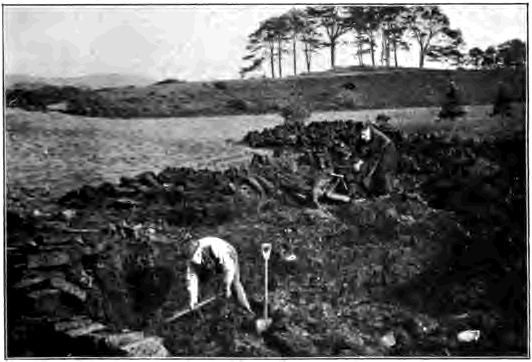
Fig. 82. Digging Peat, Scotland
When vegetation decays in open air the carbon of its tissues, taken from the atmosphere by the leaves, is oxidized and returned to it in its original form of carbon dioxide. But decomposing in the presence of water, as in a bog, where the oxygen of the air is excluded, the carbonaceous matter of plants accumulates in deposits of peat.
Peat bogs are numerous in regions lately abandoned by glacier ice, where river systems are so immature that the initial depressions left in the sheet of drift spread over the country have not yet been drained. One tenth of the surface of Ireland is said to be covered with peat, and small bogs abound in the drift-covered area of New England and the states lying as far west as the Missouri River. In Massachusetts alone it has been reckoned that there are fifteen billion cubic feet of peat, the largest bog occupying several thousand acres.
Much larger swamps occur on the young coastal plain of the Atlantic from New Jersey to Florida. The Dismal Swamp, for example, in Virginia and North Carolina is forty miles across. It is covered with a dense growth of water-loving trees such as the cypress and black gum. The center of the swamp is occupied by Lake Drummond, a shallow lake seven miles in diameter, with banks of pure-peat, and still narrowing from the encroachment of vegetation along its borders.
Salt lakes. In arid climates a lake rarely receives sufficient inflow to enable it to rise to the basin rim and find an outlet. Before this height is reached its surface becomes large enough to discharge by evaporation into the dry air the amount of water that is supplied by streams. As such a lake has no outlet, the minerals in solution brought into it by its streams cannot escape from the basin. The lake water becomes more and more heavily charged with such substances as common salt and the sulphates and carbonates of lime, of soda, and of potash, and these are thrown down from solution one after another as the point of saturation for each mineral is reached. Carbonate of lime, the least soluble and often the most abundant mineral brought in, is the first to be precipitated. As concentration goes on, gypsum, which is insoluble in a strong brine, is deposited, and afterwards common salt. As the saltness of the lake varies with the seasons and with climatic changes, gypsum and salt are laid in alternate beds and are interleaved with sedimentary clays spread from the waste brought in by streams at times of flood. Few forms of life can live in bodies of salt water so concentrated that chemical deposits take place, and hence the beds of salt, gypsum, and silt of such lakes are quite barren of the remains of life. Similar deposits are precipitated by the concentration of sea water in lagoons and arms of the sea cut off from the ocean.
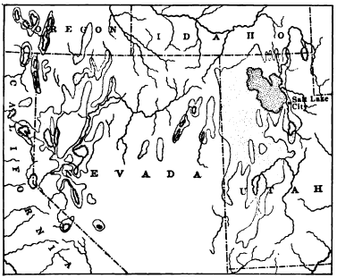
Fig. 83. Map of Lake Bonneville and Lahontan From Davis’ Physical Geography
Lakes Bonneville and Lahontan. These names are given to extinct lakes which once occupied large areas in the Great Basin, the former in Utah, the latter in northwestern Nevada. Their records remain in old horizontal beach lines which they drew along their mountainous shores at the different levels at which they stood, and in the deposits of their beds. At its highest stage Lake Bonneville, then one thousand feet deep, overflowed to the north and was a fresh-water lake. As it shrank below the outlet it became more and more salty, and the Great Salt Lake, its withered residue, is now depositing salt along its shores. In its strong brine lime carbonate is insoluble, and that brought in by streams is thrown down at once in the form of travertine.
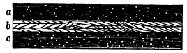
Fig. 84. Section of Deposits in Beds of Lakes Bonneville and Lahontan
Lake Lahontan never had an outlet. The first chemical deposits to be made along its shores were deposits of travertine, in places eighty feet thick. Its floor is spread with fine clays, which must have been laid in deep, still water, and which are charged with the salts absorbed by them as the briny water of the lake dried away. These sedimentary clays are in two divisions, the upper and lower, each being about one hundred feet thick (a and c, Fig. 84). They are separated by heavy deposits of well-rounded, cross-bedded gravels and sands (b, Fig. 84), similar to those spread at the present time by the intermittent streams of arid regions. A similar record is shown in the old floors of Lake Bonneville. What conclusions do you draw from these facts as to the history of these ancient lakes?
Deltas
In the river deposits which are left above sea level particles of waste are allowed to linger only for a time. From alluvial fans and flood plains they are constantly being taken up and swept farther on downstream. Although these land forms may long persist, the particles which compose them are ever changing. We may therefore think of the alluvial deposits of a valley as a stream of waste fed by the waste mantle as it creeps and washes down the valley sides, and slowly moving onwards to the sea.
In basins waste finds a longer rest, but sooner or later lakes and dry basins are drained or filled, and their deposits, if above sea level, resume their journey to their final goal. It is only when carried below the level of the sea that they are indefinitely preserved.
On reaching this terminus, rivers deliver their load to the ocean. In some cases the ocean is able to take it up by means of strong tidal and other currents, and to dispose of it in ways which we shall study later. But often the load is so large, or the tides are so weak, that much of the waste which the river brings in settles at its mouth, there building up a deposit called the delta, from the Greek letter (Δ) of that name, whose shape it sometimes resembles.
Deltas and alluvial fans have many common characteristics. Both owe their origin to a sudden check in the velocity of the river, compelling a deposit of the load; both are triangular in outline, the apex pointing upstream; and both are traversed by distributaries which build up all parts in turn.
In a delta we may distinguish deposits of two distinct kinds,— the submarine and the subaërial. In part a delta is built of waste brought down by the river and redistributed and spread by waves and tides over the sea bottom adjacent to the river’s mouth. The origin of these deposits is recorded in the remains of marine animals and plants which they contain.
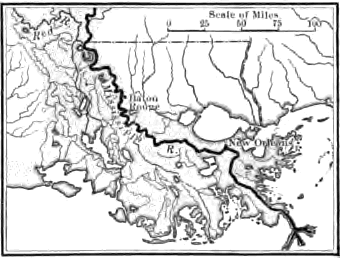
Fig. 85. Delta of the Mississippi River
As the submarine delta grows near to the level of the sea the distributaries of the river cover it with subaërial deposits altogether similar to those of the flood plain, of which indeed the subaërial delta is the prolongation. Here extended deposits of peat may accumulate in swamps, and the remains of land and fresh- water animals and plants swept down by the stream are imbedded in the silts laid at times of flood.
Borings made in the deltas of great rivers such as the Mississippi, the Ganges, and the Nile, show that the subaërial portion often reaches a surprising thickness. Layers of peat, old soils, and forest grounds with the stumps of trees are discovered hundreds of feet below sea level. In the Nile delta some eight layers of coarse gravel were found interbedded with river silts, and in the Ganges delta at Calcutta a boring nearly five hundred feet in depth stopped in such a layer.
The Mississippi has built a delta of twelve thousand three hundred square miles, and is pushing the natural embankments of its chief distributaries into the Gulf at a maximum rate of a mile in sixteen years. Muddy shoals surround its front, shallow lakes, e.g. lakes Pontchartrain and Borgne, are formed between the growing delta and the old shore line, and elongate lakes and swamps are inclosed between the natural embankments of the distributaries.
The delta of the Indus River, India, lies so low along shore that a broad tract of country is overflowed by the highest tides. The submarine portion of the delta has been built to near sea level over so wide a belt offshore that in many places large vessels cannot come even within sight of land because of the shallow water.
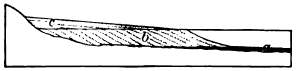
Fig. 86. Radial Section of a Delta
This section of a delta illustrates the structure of the platform which swift streams well loaded with coarse waste build in the water bodies into which they empty. Three members may be distinguished: the bottom set beds, a: the fore set beds, b; and the top set beds, c. Account for the slope of each of these. Why are the bottom set beds of the finer material and why do they extend beyond the others? How does the profile of this delta differ from that of an alluvial cone and why?
A former arm of the sea, the Rann of Cutch, adjoining the delta on the east has been silted up and is now an immense barren flat of sandy mud two hundred miles in length and one hundred miles in greatest breadth. Each summer it is flooded with salt water when the sea is brought in by strong southwesterly monsoon winds, and the climate during the remainder of the year is hot and dry. By the evaporation of sea water the soil is thus left so salty that no vegetation can grow upon it, and in places beds of salt several feet in thickness have accumulated. Under like conditions salt beds of great thickness have been formed in the past and are now found buried among the deposits of ancient deltas.
Subsidence of great deltas. As a rule great deltas are slowly sinking. In some instances upbuilding by river deposits has gone on as rapidly as the region has subsided. The entire thickness of the Ganges delta, for example, so far as it has been sounded, consists of deposits laid in open air. In other cases interbedded limestones and other sedimentary rocks containing marine fossils prove that at times subsidence has gained on the upbuilding and the delta has been covered with the sea.
It is by gradual depression that delta deposits attain enormous thickness, and, being lowered beneath the level of the sea, are safely preserved from erosion until a movement of the earth’s crust in the opposite direction lifts them to form part of the land. We shall read later in the hard rocks of our continent the records of such ancient deltas, and we shall not be surprised to find them as thick as are those now building at the mouths of great rivers.
Lake deltas. Deltas are also formed where streams lose their velocity on entering the still waters of lakes. The shore lines of extinct lakes, such as Lake Agassiz and Lakes Bonneville and Lahontan, may be traced by the heavy deposits at the mouths of their tributary streams.
• • • • •
We have seen that the work of streams is to drain the lands of the water poured upon them by the rainfall, to wear them down, and to carry their waste away to the sea, there to be rebuilt by other agents into sedimentary rocks. The ancient strata of which the continents are largely made are composed chiefly of material thus worn from still more ancient lands—lands with their hills and valleys like those of to-day—and carried by their rivers to the ocean. In all geological times, as at the present, the work of streams has been to destroy the lands, and in so doing to furnish to the ocean the materials from which the lands of future ages were to be made. Before we consider how the waste of the land brought in by streams is rebuilt upon the ocean floor, we must proceed to study the work of two agents, glacier ice and the wind, which cooperate with rivers in the denudation of the land.
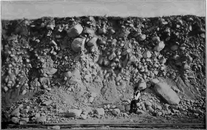
Fig. 87. Section of Undifferentiated Drift near Chicago
CHAPTER V
THE WORK OF GLACIERS
The drift. The surface of northeastern North America, as far south as the Ohio and Missouri rivers, is generally covered by the drift,—a formation which is quite unlike any which we have so far studied. A section of it, such as that illustrated in Figure 87, shows that for the most part it is unstratified, consisting of clay, sand, pebbles, and even large bowlders, all mingled pell- mell together. The agent which laid the drift is one which can carry a load of material of all sizes, from the largest bowlder to the finest clay, and deposit it without sorting.