Front matter (continued 4)
Reading edition · Edition 2
The impalpable powder to which calcareous sand is ground by the waves settles at some distance from shore in deeper and quieter water as a limy silt, and hardens into a dense, fine-grained limestone in which perhaps no trace of fossil is found to suggest the fact that it is of organic origin.
From Florida Keys there extends south to the trough of Florida Straits a limestone bank covered by from five hundred and forty to eighteen hundred feet of water. The rocky bottom consists of limestone now slowly building from the accumulation of the remains of mollusks, small corals, sea urchins, worms with calcareous tubes, and lime-secreting seaweed, which live upon its surface.
Where sponges and other silica-secreting organisms abound on limestone banks, silica forms part of the accumulated deposit, either in its original condition, as, for example, the spicules of sponges, or gathered into concretions and layers of flint.
Where considerable mud is being deposited along with carbonate of lime there is in process of making a clayey limestone or a limy shale; where considerable sand, a sandy limestone or a limy sandstone.
Consolidation of offshore deposits. We cannot doubt that all these loose sediments of the sea floor are being slowly consolidated to solid rock. They are soaked with water which carries in solution lime carbonate and other cementing substances. These cements are deposited between the fragments of shells and corals, the grains of sand and the particles of mud, binding them together into firm rock. Where sediments have accumulated to great thickness the lower portions tend also to consolidate under the weight of the overlying beds. Except in the case of limestones, recent sea deposits uplifted to form land are seldom so well cemented as are the older strata, which have long been acted upon by underground waters deep below the surface within the zone of cementation, and have been exposed to view by great erosion.
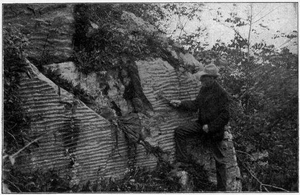
Fig. 150. Ripple Marks on Layers of Ancient Sandstone, Wisconsin
Ripple marks, sun cracks, etc. The pulse of waves and tidal currents agitates the loose material of offshore deposits, throwing it into fine parallel ridges called ripple marks. One may see this beautiful ribbing imprinted on beach sands uncovered by the outgoing tide, and it is also produced where the water is of considerable depth. While the tide is out the surface of shore deposits may be marked by the footprints of birds and other animals, or by the raindrops of a passing shower (Fig. 153). The mud of flats, thus exposed to the sun and dried, cracks in a characteristic way (Figs. 151 and 152). Such markings may be covered over with a thin layer of sediment at the next flood tide and sealed away as a lasting record of the manner and place in which the strata were laid. In Figure 150 we have an illustration of a very ancient ripple-marked sand consolidated to hard stone, uplifted and set on edge by movements of the earth’s crust, and exposed to open air after long erosion.
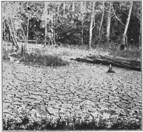
Fig. 151. Sun Cracks
Stratification. For the most part the sheet of sea-laid waste is hidden from our sight. Where its edge is exposed along the shore we may see the surface markings which have just been noticed. Soundings also, and the observations made in shallow waters by divers, tell something of its surface; but to learn more of its structures we must study those ancient sediments which have been lifted from the sea and dissected by subaërial agencies. From them we ascertain that sea deposits are stratified. They lie in distinct layers which often differ from one another in thickness, in size of particles, and perhaps in color. They are parted by bedding planes, each of which represents either a change in material or a pause during which deposition ceased and the material of one layer had time to settle and become somewhat consolidated before the material of the next was laid upon it. Stratification is thus due to intermittently acting forces, such as the agitation of the water during storms, the flow and ebb of the tide, and the shifting channels of tidal currents. Off the mouths of rivers, stratification is also caused by the coarser and more abundant material brought down at time of floods being laid on the finer silt which is discharged during ordinary stages.
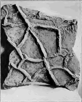
Fig. 152. The Under Side of a Layer deposited upon a Sun-Cracked Surface, showing Casts of the Cracks
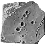
Fig. 153. Rain Prints
How stratified deposits are built up is well illustrated in the flats which border estuaries, such as the Bay of Fundy. Each advance of the tide spreads a film of mud, which dries and hardens in the air during low water before another film is laid upon it by the next incoming tidal flood. In this way the flats have been covered by a clay which splits into leaves as thin as sheets of paper.
It is in fine material, such as clays and shales and limestones, that the thinnest and most uniform layers, as well as those of widest extent, occur. On the other hand, coarse materials are commonly laid in thick beds, which soon thin out seaward and give place to deposits of finer stuff. In a general way strata are laid in well-nigh horizontal sheets, for the surface on which they are laid is generally of very gentle inclination. Each stratum, however, is lenticular, or lenslike, in form, having an area where it is thickest, and thinning out thence to its edges, where it is overlapped by strata similar in shape.
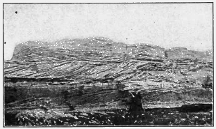
Fig. 154. Cross Bedding in Sandstone, England
Cross bedding. There is an apparent exception to this rule where strata whose upper and lower surfaces may be about horizontal are made up of layers inclined at angles which may be as high as the angle of repose. In this case each stratum grew by the addition along its edge of successive layers of sediment, precisely as does a sand bar in a river, the sand being pushed continuously over the edge and coming to rest on a sloping surface. Shoals built by strong and shifting tidal currents often show successive strata in which the cross bedding is inclined in different directions.
Thickness of sea deposits. Remembering the vast amount of material denuded from the land and deposited offshore, we should expect that with the lapse of time sea deposits would have grown to an enormous thickness. It is a suggestive fact that, as a rule, the profile of the ocean bed is that of a soup plate,—a basin surrounded by a flaring rim. On the continental shelf, as the rim is called, the water is seldom more than six hundred feet in depth at the outer edge, and shallows gradually towards shore. Along the eastern coast of the United States the continental shelf is from fifty to one hundred and more miles in width; on the Pacific coast it is much narrower. So far as it is due to upbuilding, a wide continental shelf, such as that of the Atlantic coast, implies a massive continental delta thousands of feet in thickness. The coastal plain of the Atlantic states may be regarded as the emerged inner margin of this shelf, and borings made along the coast probe it to the depth of as much as three thousand feet without finding the bottom of ancient offshore deposits. Continental shelves may also be due in part to a submergence of the outer margin of a continental plateau and to marine abrasion.
Deposition of sediments and subsidence. The stratified rocks of the land show in many places ancient sediments which reach a thickness which is measured in miles, and which are yet the product of well-nigh continuous deposition. Such strata may prove by their fossils and by their composition and structure that they were all laid offshore in shallow water. We must infer that, during the vast length of time recorded by the enormous pile, the floor of the sea along the coast was slowly sinking, and that the trough was constantly being filled, foot by foot, as fast as it was depressed. Such gradual, quiet movements of the earth’s crust not only modify the outline of coasts, as we have seen, but are of far greater geological importance in that they permit the making of immense deposits of stratified rock.
A slow subsidence continued during long time is recorded also in the succession of the various kinds of rock that come to be deposited in the same area. As the sea transgresses the land, i.e. encroaches upon it, any given part of the sea bottom is brought farther and farther from the shore. The basal conglomerate formed by bowlder and pebble beaches comes to be covered with sheets of sand, and these with layers of mud as the sea becomes deeper and the shore more remote; while deposits of limestone are made when at last no waste is brought to the place from the now distant land, and the water is left clear for the growth of mollusks and other lime-secreting organisms.
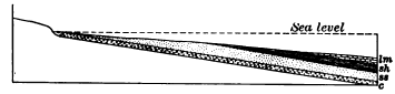
Fig. 155. Succession of Deposits recording a Transgressing Sea c, conglomerate; ss, sandstone; sh, shale; lm, limestone
Rate of deposition. As deposition in the sea corresponds to denudation on the land, we are able to make a general estimate of the rate at which the former process is going on. Leaving out of account the soluble matter removed, the Mississippi is lowering its basin at the rate of one foot in five thousand years, and we may assume this as the average rate at which the earth’s land surface of fifty-seven million square miles is now being denuded by the removal of its mechanical waste. But sediments from the land are spread within a zone but two or three hundred miles in width along the margin of the continents, a line one hundred thousand miles long. As the area of deposition—about twenty-five million square miles—is about one half the area of denudation, the average rate of deposition must be twice the average rate of denudation, i.e. about one foot in twenty-five hundred years. If some deposits are made much more rapidly than this, others are made much more slowly. If they were laid no faster than the present average rate, the strata of ancient sea deposits exposed in a quarry fifty feet deep represent a lapse of at least one hundred and twenty-five thousand years, and those of a formation five hundred feet thick required for their accumulation one million two hundred and fifty thousand years.
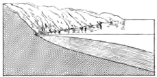
Fig. 156. Thick Offshore Deposits of Coarse Waste recording the Presence of a Young Mountain Range near Shore
The sedimentary record and the denudation cycle. We have seen that the successive stages in a cycle of denudation, such as that by which a land mass of lofty mountains is worn to low plains, are marked each by its own peculiar land forms, and that the forms of the earlier stages are more or less completely effaced as the cycle draws toward an end. Far more lasting records of each stage are left in the sedimentary deposits of the continental delta. Thus, in the youth of such a land mass as we have mentioned, torrential streams flowing down the steep mountain sides deliver to the adjacent sea their heavy loads of coarse waste, and thick offshore deposits of sand and gravel (Fig. 156) record the high elevation of the bordering land. As the land is worn to lower levels, the amount and coarseness of the waste brought to the sea diminishes, until the sluggish streams carry only a fine silt which settles on the ocean floor near to land in wide sheets of mud which harden into shale. At last, in the old age of the region (Fig. 157), its low plains contribute little to the sea except the soluble elements of the rocks, and in the clear waters near the land lime-secreting organisms flourish and their remains accumulate in beds of limestone. When long-weathered lands mantled with deep, well-oxidized waste are uplifted by a gradual movement of the earth’s crust, and the mantle is rapidly stripped off by the revived streams, the uprise is recorded in wide deposits of red and yellow clays and sands upon the adjacent ocean floor.
Where the waste brought in is more than the waves can easily distribute, as off the mouths of turbid rivers which drain highlands near the sea, deposits are little winnowed, and are laid in rapidly alternating, shaly sandstones and sandy shales.

Fig. 157. Offshore Deposits recording Old Age of the Adjacent Land ss, sandstone; sh, shale; lm, limestone
Where the highlands are of igneous rock, such as granite, and mechanical disintegration is going on more rapidly than chemical decay, these conditions are recorded in the nature of the deposits laid offshore. The waste swept in by streams contains much feldspar and other minerals softer and more soluble than quartz, and where the waves have little opportunity to wear and winnow it, it comes to rest in beds of sandstone in which grains of feldspar and other soft minerals are abundant. Such feldspathic sandstones are known as arkose.
On the other hand, where the waste supplied to the sea comes chiefly from wide, sandy, coastal plains, there are deposited off- shore clean sandstones of well-worn grains of quartz alone. In such coastal plains the waste of the land is stored for ages. Again and again they are abandoned and invaded by the sea as from time to time the land slowly emerges and is again submerged. Their deposits are long exposed to the weather, and sorted over by the streams, and winnowed and worked over again and again by the waves. In the course of long ages such deposits thus become thoroughly sorted, and the grains of all minerals softer than quartz are ground to mud.
Deep-Sea Oozes and Clays

Fig. 158. Globigerina Ooze under the Microscope
Globigerina ooze. Beyond the reach of waste from the land the bottom of the deep sea is carpeted for the most part with either chalky ooze or a fine red clay. The surface waters of the warm seas swarm with minute and lowly animals belonging to the order of the Foraminifera, which secrete shells of carbonate of lime. At death these tiny white shells fall through the sea water like snowflakes in the air, and, slowly dissolving, seem to melt quite away before they can reach depths greater than about three miles. Near shore they reach bottom, but are masked by the rapid deposit of waste derived from the land. At intermediate depths they mantle the ocean floor with a white, soft lime deposit known as Globigerina ooze, from a genus of the Foraminifera which contributes largely to its formation.
Red clay. Below depths of from fifteen to eighteen thousand feet the ocean bottom is sheeted with red or chocolate colored clay. It is the insoluble residue of seashells, of the débris of submarine volcanic eruptions, of volcanic dust wafted by the winds, and of pieces of pumice drifted by ocean currents far from the volcanoes from which they were hurled. The red clay builds up with such inconceivable slowness that the teeth of sharks and the hard ear bones of whales may be dredged in large numbers from the deep ocean bed, where they have lain unburied for thousands of years; and an appreciable part of the clay is also formed by the dust of meteorites consumed in the atmosphere,—a dust which falls everywhere on sea and land, but which elsewhere is wholly masked by other deposits.
The dark, cold abysses of the ocean are far less affected by change than any other portion of the surface of the lithosphere. These vast, silent plains of ooze lie far below the reach of storms. They know no succession of summer and winter, or of night and day. A mantle of deep and quiet water protects them from the agents of erosion which continually attack, furrow, and destroy the surface of the land. While the land is the area of erosion, the sea is the area of deposition. The sheets of sediment which are slowly spread there tend to efface any inequalities, and to form a smooth and featureless subaqueous plain.
With few exceptions, the stratified rocks of the land are proved by their fossils and composition to have been laid in the sea; but in the same way they are proved to be offshore, shallow-water deposits, akin to those now making on continental shelves. Deep- sea deposits are absent from the rocks of the land, and we may therefore infer that the deep sea has never held sway where the continents now are,—that the continents have ever been, as now, the elevated portions of the lithosphere, and that the deep seas of the present have ever been its most depressed portions.
The Reef-Building Corals
In warm seas the most conspicuous of rock-making organisms are the corals known as the reef builders. Floating in a boat over a coral reef, as, for example, off the south coast of Florida or among the Bahamas, one looks down through clear water on thickets of branching coral shrubs perhaps as much as eight feet high, and hemispherical masses three or four feet thick, all abloom with countless minute flowerlike coral polyps, gorgeous in their colors of yellow, orange, green, and red. In structure each tiny polyp is little more than a fleshy sac whose mouth is surrounded with petal-like tentacles, or feelers. From the sea water the polyps secrete calcium carbonate and build it up into the stony framework which supports their colonies. Boring mollusks, worms, and sponges perforate and honeycomb this framework even while its surface is covered with myriads of living polyps. It is thus easily broken by the waves, and white fragments of coral trees strew the ground beneath. Brilliantly colored fishes live in these coral groves, and countless mollusks, sea urchins, and other forms of marine life make here their home. With the débris from all these sources the reef is constantly built up until it rises to low-tide level. Higher than this the corals cannot grow, since they are killed by a few hours’ exposure to the air.
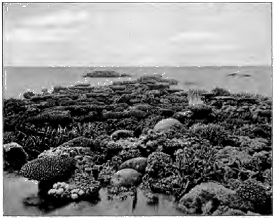
Fig. 159. Patch of Growing Corals exposed at an Exceptionally Low Tide, Great Barrier Reef, Australia
When the reef has risen to wave base, the waves abrade it on the windward side and pile to leeward coral blocks torn from their foundation, filling the interstices with finer fragments. Thus they heap up along the reef low, narrow islands (Fig. 160).
Reef building is a comparatively rapid progress. It has been estimated that off Florida a reef could be built up to the surface from a depth of fifty feet in about fifteen hundred years.

Fig. 160. Wave-Built Island on Coral Reef r, reef; sl, sea level
Coral limestones. Limestones of various kinds are due to the reef builders. The reef rock is made of corals in place and broken fragments of all sizes, cemented together with calcium carbonate from solution by infiltrating waters. On the island beaches coral sand is forming oolitic limestone, and the white coral mud with which the sea is milky for miles about the reef in times of storm settles and concretes into a compact limestone of finest grain. Corals have been among the most important limestone builders of the sea ever since they made their appearance in the early geological ages.
The areas on which coral limestone is now forming are large. The Great Barrier Reef of Australia, which lies off the north-eastern coast, is twelve hundred and fifty miles long, and has a width of from ten to ninety miles. Most of the islands of the tropics are either skirted with coral reefs or are themselves of coral formation.
Conditions of coral growth. Reef-building corals cannot live except in clear salt water less, as a rule, than one hundred and fifty feet in depth, with a winter temperature not lower than 68° F. An important condition also is an abundant food supply, and this is best secured in the path of the warm oceanic currents.
Coral reefs may be grouped in three classes,—fringing reefs, barrier reefs, and atolls.
Fringing reefs. These take their name from the fact that they are attached as narrow fringes to the shore. An example is the reef which forms a selvage about a mile wide along the northeastern coast of Cuba. The outer margin, indicated by the line of white surf, where the corals are in vigorous growth, rises from about forty feet of water. Between this and the shore lies a stretch of shoal across which one can wade at low water, composed of coral sand with here and there a clump of growing coral.
Barrier reefs. Reefs separated from the shore by a ship channel of quiet water, often several miles in width and sometimes as much as three hundred feet in depth, are known as barrier reefs. The seaward face rises abruptly from water too deep for coral growth. Low islands are cast up by the waves upon the reef, and inlets give place for the ebb and flow of the tides. Along the west coast of the island of New Caledonia a barrier reef extends for four hundred miles, and for a length of many leagues seldom approaches within eight miles of the shore.
Atolls. These are ring-shaped or irregular coral islands, or island-studded reefs, inclosing a central lagoon. The narrow zone of land, like the rim of a great bowl sunken to the water’s edge, rises hardly more than twenty feet at most above the sea, and is covered with a forest of trees such as the cocoanut, whose seeds can be drifted to it uninjured from long distances. The white beach of coral sand leads down to the growing reef, on whose outer margin the surf is constantly breaking. The sea face of the reef falls off abruptly, often to depths of thousands of feet, while the lagoon varies in depth from a few feet to one hundred and fifty or two hundred, and exceptionally measures as much as three hundred and fifty feet.
Theories of coral reefs. Fringing reefs require no explanation, since the depth of water about them is not greater than that at which coral can grow; but barrier reefs and atolls, which may rise from depths too great for coral growth demand a theory of their origin.
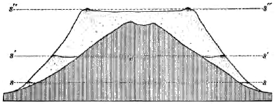
Fig. 161. Diagram illustrating the Subsidence Theory of Coral Reefs
Darwin’s theory holds that barrier reefs and atolls are formed from fringing reefs by subsidence. The rate of sinking cannot be greater than that of the upbuilding of the reef, since otherwise the corals would be carried below their depth and drowned. The process is illustrated in Figure 161, where v represents a volcanic island in mid ocean undergoing slow depression, and ss the sea level before the sinking began, when the island was surrounded by a fringing reef. As the island slowly sinks, the reef builds up with equal pace. It rears its seaward face more steep than the island slope, and thus the intervening space between the sinking, narrowing land and the outer margin of the reef constantly widens. In this intervening space the corals are more or less smothered with silt from the outer reef and from the land, and are also deprived in large measure of the needful supply of food and oxygen by the vigorous growth of the corals on the outer rim. The outer rim thus becomes a barrier reef and the inner belt of retarded growth is deepened by subsidence to a ship channel, s´s´ representing sea level at this time. The final stage, where the island has been carried completely beneath the sea and overgrown by the contracting reef, whose outer ring now forms an atoll, is represented by s´´s´´.
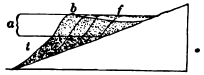
Fig. 162. Barrier Reef formed without Subsidence a, zone of coral growth; f, former fringing reef; t, talus; b, barrier reef
In very many instances, however, atolls and barrier reefs may be explained without subsidence. Thus a barrier reef may be formed by the seaward growth of a fringing reef upon the talus of its sea face. In Figure 162, f is a fringing reef whose outer wall rises from about one hundred and fifty feet, the lower limit of the reef-building species. At the foot of this submarine cliff a talus of fallen blocks t accumulates, and as it reaches the zone of coral growth becomes the foundation on which the reef is steadily extended seaward. As the reef widens, the polyps of the circumference flourish, while those of the inner belt are retarded in their growth and at last perish. The coral rock of the inner belt is now dissolved by sea water and scoured out by tidal currents until it gives place to a gradually deepening ship channel, while the outer margin is left as a barrier reef.
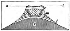
Fig. 163. Section of Atoll on a Shoal which has been built up to near the Surface by Organic Deposits upon a Submarine Volcanic Peak v, volcano; f, foraminiferal deposits; m, molluscous shell deposits; c, coral reef; sl, sea level
In much the same way atolls may be built on any shoal which lies within the zone of coral growth. Such shoals may be produced when volcanic islands are leveled by waves and ocean currents, and when submarine plateaus, ridges, and peaks are built up by various organic agencies, such as molluscous and foraminiferal shell deposits (Fig. 163). The reef-building corals, whose eggs are drifted widely over the tropic seas by ocean currents, colonize such submarine foundations wherever the conditions are favorable for their growth. As the reef approaches the surface the corals of the inner area are smothered by silt and starved, and their Submarine Volcanic Peak hard parts are dissolved and scoured away; while those of the circumference, with abundant food supply, nourish and build the ring of the atoll. Atolls may be produced also by the backward drift of sand from either end of a crescentic coral reef or island, the spits uniting in the quiet water of the lee to inclose a lagoon. In the Maldive Archipelago all gradations between crescent-shaped islets and complete atoll rings have been observed.
In a number of instances where coral reefs have been raised by movements of the earth’s crust, the reef formation is found to be a thin veneer built upon a foundation of other deposits. Thus Christmas Island, in the Indian Ocean, is a volcanic pile rising eleven hundred feet above sea level and fifteen thousand five hundred feet above the bottom of the sea. The summit is a plateau surrounded by a rim of hills of reef formation, which represent the ring of islets of an ancient atoll. Beneath the reef are thick beds of limestone, composed largely of the remains of foraminifers, which cover the lavas and fragmental materials of the old submarine volcano.
Among the ancient sediments which now form the stratified rocks of the land there occur many thin reef deposits, but none are known of the immense thickness which modern reefs are supposed to reach according to the theory of subsidence.
Barrier and fringing reefs are commonly interrupted off the mouths of rivers. Why?
Summary. We have seen that the ocean bed is the goal to which the waste of the rocks of the land at last arrives. Their soluble parts, dissolved by underground waters and carried to the sea by rivers, are largely built up by living creatures into vast sheets of limestone. The less soluble portions—the waste brought in by streams and the waste of the shore—form the muds and sands of continental deltas. All of these sea deposits consolidate and harden, and the coherent rocks of the land are thus reconstructed on the ocean floor. But the destination is not a final one. The stratified rocks of the land are for the most part ancient deposits of the sea, which have been lifted above sea level; and we may believe that the sediments now being laid offshore are the “dust of continents to be,” and will some time emerge to form additions to the land. We are now to study the movements of the earth’s crust which restore the sediments of the sea to the light of day, and to whose beneficence we owe the habitable lands of the present.
PART II
INTERNAL GEOLOGICAL AGENCIES
CHAPTER IX
MOVEMENTS OF THE EARTH’S CRUST
The geological agencies which we have so far studied—weathering, streams, underground waters, glaciers, winds, and the ocean—all work upon the earth from without, and all are set in motion by an energy external to the earth, namely, the radiant energy of the sun. All, too, have a common tendency to reduce the inequalities of the earth’s surface by leveling the lands and strewing their waste beneath the sea.
But despite the unceasing efforts of these external agencies, they have not destroyed the continents, which still rear their broad plains and great plateaus and mountain ranges above the sea. Either, then, the earth is very young and the agents of denudation have not yet had time to do their work, or they have been opposed successfully by other forces.
We enter now upon a department of our science which treats of forces which work upon the earth from within, and increase the inequalities of its surface. It is they which uplift and recreate the lands which the agents of denudation are continually destroying; it is they which deepen the ocean bed and thus withdraw its waters from the shores. At times also these forces have aided in the destruction of the lands by gradually lowering them and bringing in the sea. Under the action of forces resident within the earth the crust slowly rises or sinks; from time to time it has been folded and broken; while vast quantities of molten rock have been pressed up into it from beneath and outpoured upon its surface. We shall take up these phenomena in the following chapters, which treat of upheavals and depressions of the crust, foldings and fractures of the crust, earthquakes, volcanoes, the interior conditions of the earth, mineral veins, and metamorphism.
Oscillations of the Crust
Of the various movements of the crust due to internal agencies we will consider first those called oscillations, which lift or depress large areas so slowly that a long time is needed to produce perceptible changes of level, and which leave the strata in nearly their original horizontal attitude. These movements are most conspicuous along coasts, where they can be referred to the datum plane of sea level; we will therefore take our first illustrations from rising and sinking shores.
New Jersey. Along the coasts of New Jersey one may find awash at high tide ancient shell heaps, the remains of tribal feasts of aborigines. Meadows and old forest grounds, with the stumps still standing, are now overflowed by the sea, and fragments of their turf and wood are brought to shore by waves. Assuming that the sea level remains constant, it is clear that the New Jersey coast is now gradually sinking. The rate of submergence has been estimated at about two feet per century.
On the other hand, the wide coastal plain of New Jersey is made of stratified sands and clays, which, as their marine fossils show, were outspread beneath the sea. Their present position above sea level proves that the land now subsiding emerged in the recent past.
The coast of New Jersey is an example of the slow and tranquil oscillations of the earth’s unstable crust now in progress along many shores. Some are emerging from the sea, some are sinking beneath it; and no part of the land seems to have been exempt from these changes in the past.
Evidences of changes of level. Taking the surface of the sea as a level of reference, we may accept as proofs of relative upheaval whatever is now found in place above sea level and could have been formed only at or beneath it, and as proofs of relative subsidence whatever is now found beneath the sea and could only have been formed above it.
Thus old strand lines with sea cliffs, wave-cut rock benches, and beaches of wave-worn pebbles or sand, are striking proofs of recent emergence to the amount of their present height above tide. No less conclusive is the presence of sea-laid rocks which we may find in the neighboring quarry or outcrop, although it may have been long ages since they were lifted from the sea to form part of the dry land.
Among common proofs of subsidence are roads and buildings and other works of man, and vegetal growths and deposits, such as forest grounds and peat beds, now submerged beneath the sea. In the deltas of many large rivers, such as the Po, the Nile, the Ganges, and the Mississippi, buried soils prove subsidences of hundreds of feet; and in several cases, as in the Mississippi delta, the depression seems to be now in progress.
Other proofs of the same movement are drowned land forms which are modeled only in open air. Since rivers cannot cut their valleys farther below the baselevel of the sea than the depths of their channels, drowned valleys are among the plainest proofs of depression. To this class belong Narragansett, Delaware, Chesapeake, Mobile, and San Francisco bays, and many other similar drowned valleys along the coasts of the United States. Less conspicuous are the submarine channels which, as soundings show, extend from the mouths of a number of rivers some distance out to sea. Such is the submerged channel which reaches from New York Bay southeast to the edge of the continental shelf, and which is supposed to have been cut by the Hudson River when this part of the shelf was a coastal plain.
Warping. In a region undergoing changes of level the rate of movement commonly varies in different parts. Portions of an area may be rising or sinking, while adjacent portions are stationary or moving in the opposite direction. In this way a land surface becomes warped. Thus, while Nova Scotia and New Brunswick are now rising from the level of the sea, Prince Edward Island and Cape Breton Island are sinking, and the sea now flows over the site of the famous old town of Louisburg destroyed in 1758.
Since the close of the glacial epoch the coasts of Newfoundland and Labrador have risen hundreds of feet, but the rate of emergence has not been uniform. The old strand line, which stands at five hundred and seventy-five feet above tide at St. John’s, Newfoundland, declines to two hundred and fifty feet near the northern point of Labrador (Fig. 164).
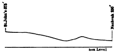
Fig. 164. Warped Strand Line from St. John’s, Newfoundland, to Nachvak, Labrador
The Great Lakes is now under-going perceptible warping. Rivers enter the lakes from the south and west with sluggish currents and deep channels resembling the estuaries of drowned rivers; while those that enter from opposite directions are swift and shallow. At the western end of Lake Erie are found submerged caves containing stalactites, and old meadows and forest grounds are now under water. It is thus seen that the water of the lakes is rising along their southwestern shores, while from their north-eastern shores it is being withdrawn. The region of the Great Lakes is therefore warping; it is rising in the northeast as compared with the southwest.
From old bench marks and records of lake levels it has been estimated that the rate of warping amounts to five inches a century for every one hundred miles. It is calculated that the water of Lake Michigan is rising at Chicago at the rate of nine or ten inches per century. The divide at this point between the tributaries of the Mississippi and Lake Michigan is but eight feet above the mean stage of the lake. If the canting of the region continues at its present rate, in a thousand years the waters of the lake will here overflow the divide. In three thousand five hundred years all the lakes except Ontario will discharge by this outlet, via the Illinois and Mississippi rivers, into the Gulf of Mexico. The present outlet by the Niagara River will be left dry, and the divide between the St. Lawrence and the Mississippi systems will have shifted from Chicago to the vicinity of Buffalo.
Physiographic effects of oscillations. We have already mentioned several of the most important effects of movements of elevation and depression, such as their effects on rivers, the mantle of waste (pp. 85, 86), and the forms of coasts (p. 166). Movements of elevation—including uplifts by folding and fracture of the crust to be noticed later— are the necessary conditions for erosion by whatever agent. They determine the various agencies which are to be chiefly concerned m the wear of any land,—whether streams or glaciers, weathering or the wind,—and the degree of their efficiency. The lands must be uplifted before they can be eroded, and since they must be eroded before their waste can be deposited, movements of elevation are a prerequisite condition for sedimentation also. Subsidence is a necessary condition for deposits of great thickness, such as those of the Great Valley of California and the Indo-Gangetic plain (p. 101), the Mississippi delta (p. 109), and the still more important formations of the continental delta in gradually sinking troughs (p. 183). It is not too much to say that the character and thickness of each formation of the stratified rocks depend primarily on these crustal movements.
Along the Baltic coast of Sweden, bench marks show that the sea is withdrawing from the land at a rate which at the north amounts to between three and four feet per century; Towards the south the rate decreases. South of Stockholm, until recent years, the sea has gained upon the land, and here in several seaboard towns streets by the shore are still submerged. The rate of oscillation increases also from the coast inland. On the other hand, along the German coast of the Baltic the only historic fluctuations of sea level are those which may be accounted for by variations due to changes in rainfall. In 1730 Celsius explained the changes of level of the Swedish coast as due to a lowering of the Baltic instead of to an elevation of the land. Are the facts just stated consistent with his theory?
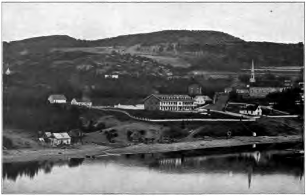
Fig. 165. Old Strand Lines, Tadousac, Quebec
At the little town of Tadousac—where the Saguenay River empties into the St. Lawrence—there are terraces of old sea beaches, some almost as fresh as recent railway fills, the highest standing two hundred and thirty feet above the river (Fig. 165). Here the Saguenay is eight hundred and forty feet in depth, and the tide ebbs and flows far up its stream. Was its channel cut to this depth by the river when the land was at its present height? What oscillations are here recorded, and to what amount?
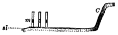
Fig. 166. Diagram showing Ruins of Temple, North of Naples C, ancient sea cliff; m, marble pillars, dotted where bored by mollusks; sl, sea level
A few miles north of Naples, Italy, the ruins of an ancient Roman temple lie by the edge of the sea, on a narrow plain which is overlooked in the rear by an old sea cliff (Fig. 166). Three marble pillars are still standing. For eleven feet above their bases these columns are uninjured, for to this height they were protected by an accumulation of volcanic ashes; but from eleven to nineteen feet they are closely pitted with the holes of boring marine mollusks. From these facts trace the history of the oscillations of the region.
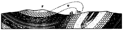
Fig. 167. Section in a Region of Folded Rocks
Foldings of the Crust
The oscillations which we have just described leave the strata not far from their original horizontal attitude. Figure 167 represents a region in which movements of a very different nature have taken place. Here, on either side of the valley v, we find outcrops of layers tilted at high angles. Sections along the ridge r show that it is composed of layers which slant inward from either side. In places the outcropping strata stand nearly on edge, and on the right of the valley they are quite overturned; a shale sh has come to overlie a limestone lm although the shale is the older rock, whose original position was beneath the limestone.
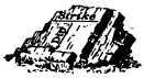
Fig. 168. Dip and Strike
It is not reasonable to suppose that these rocks were deposited in the attitude in which we find them now; we must believe that, like other stratified rocks, they were outspread in nearly level sheets upon the ocean floor. Since that time they must have been deformed. Layers of solid rock several miles in thickness have been crumpled and folded like soft wax in the hand, and a vast denudation has worn away the upper portions of the folds, in part represented in our section by dotted lines.
Dip and strike. In districts where the strata have been disturbed it is desirable to record their attitude. This is most easily done by taking the angle at which the strata are inclined and the compass direction in which they slant. It is also convenient to record the direction in which the outcrop of the strata trends across the country.
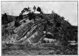
Fig. 169. An Anticline, Maryland
The inclination of a bed of rocks to the horizon is its dip (Fig. 168). The amount of the dip is the angle made with a horizontal plane. The dip of a horizontal layer is zero, and that of a vertical layer is 90°. The direction of the dip is taken with the compass. Thus a geologist’s notebook in describing the attitude of outcropping strata contains many such entries as these: dip 32° north, or dip 8° south 20° west,—meaning in the latter case that the amount of the dip is 8° and the direction of the dip bears 20° west of south.
The line of intersection of a layer with the horizontal plane is the strike. The strike always runs at right angles to the dip.
Dip and strike may be illustrated by a book set aslant on a shelf. The dip is the acute angle made with the shelf by the side of the book, while the strike is represented by a line running along the book’s upper edge. If the dip is north or south, the strike runs east and west.
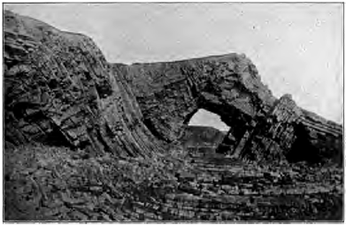
Fig. 170. Folded Strata, Coast of England A syncline in the center, with an anticline on either side
Folded structures. An upfold, in which the strata dip away from a line drawn along the crest and called the axis of the fold, is known as an anticline (Fig. 169). A downfold, where the strata dip from either side toward the axis of the trough, is called a syncline (Fig. 170). There is sometimes seen a downward bend in horizontal or gently inclined strata, by which they descend to a lower level. Such a single flexure is a monocline (Fig. 171).
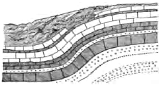
Fig. 171. A Monocline
Degrees of folding. Folds vary in degree from broad, low swells, which can hardly be detected, to the most highly contorted and complicated structures. In symmetric folds (Figs. 169 and 180) the dips of the rocks on each side the axis of the fold are equal. In unsymmetrical folds one limb is steeper than the other, as in the anticline in Figure 167. In overturned folds (Figs. 167 and 172) one limb is inclined beyond the perpendicular. Fan folds have been so pinched that the original anticlines are left broader at the top than at the bottom (Fig. 173).
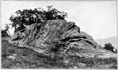
Fig. 172. Overturned Fold, Vermont
In folds where the compression has been great the layers are often found thickened at the crest and thinned along the limbs (174). Where strong rocks such as heavy limestones are folded together with weak rocks such as shales, the strong rocks are often bent into great simple folds, while the weak rocks are minutely crumpled.
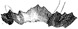
Fig. 173. Fan Folds, the Alps
Systems of folds. As a rule, folds occur in systems. Over the Appalachian mountain belt, for example, extending from northeastern Pennsylvania to northern Alabama and Georgia, the earth’s crust has been thrown into a series of parallel folds whose axes run from northeast to southwest (Fig. 175). In Pennsylvania one may count a score or more of these earth waves,— some but from ten to twenty miles in length, and some extending as much as two hundred miles before they die away. On the eastern part of this belt the folds are steeper and more numerous than on the western side.
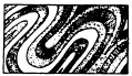
Fig. 174. Folds with Layers thickened at the Crest and thinned along the Limbs
Cause and conditions of folding. The sections which we have studied suggest that rocks are folded by lateral pressure. While a single, simple fold might be produced by a heave, a series of folds, including overturns, fan folds, and folds thickened on their crests at the expense of their limbs, could only be made in one way,—by pressure from the side. Experiment has reproduced all forms of folds by subjecting to lateral thrust layers of plastic material such as wax.
Vast as the force must have been which could fold the solid rocks of the crust as one may crumple the leaves of a magazine in the fingers, it is only under certain conditions that it could have produced the results which we see. Rocks are brittle, and it is only when under a heavy load and by great pressure slowly applied, that they can thus be folded and bent instead of being crushed to pieces. Under these conditions, experiments prove that not only metals such as steel, but also brittle rocks such as marble, can be deformed and molded and made to flow like plastic clay.
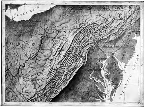
Fig. 175. Relief Map of the Northern Appalachian Region From Bingham’s Geographic Influences in American History
Zone of flow, zone of flow and fracture, and zone of fracture. We may believe that at depths which must be reckoned in tens of thousands of feet the load of overlying rocks is so great that rocks of all kinds yield by folding to lateral pressure, and flow instead of breaking. Indeed, at such profound depths and under such inconceivable weight no cavity can form, and any fractures would be healed at once by the welding of grain to grain. At less depths there exists a zone where soft rocks fold and flow under stress, and hard rocks are fractured; while at and near the surface hard and soft rocks alike yield by fracture to strong pressure.
Structures developed in Compressed Rocks
Deformed rocks show the effects of the stresses to which they have yielded, not only in the immense folds into which they have been thrown but in their smallest parts as well. A hand specimen of slate, or even a particle under the microscope, may show plications similar in form and origin to the foldings which have produced ranges of mountains. A tiny flake of mica in the rocks of the Alps may be puckered by the same resistless forces which have folded miles of solid rock to form that lofty range.
Slaty cleavage. Rocks which have yielded to pressure often split easily in a certain direction across the bedding planes. This cleavage is known as slaty cleavage, since it is most perfectly developed in fine-grained, homogeneous rocks, such as slates, which cleave to the thin, smooth-surfaced plates with which we are familiar in the slates used in roofing and for ciphering and blackboards. In coarse-grained rocks, pressure develops more distant partings which separate the rocks into blocks.
Slaty cleavage cannot be due to lamination, since it commonly crosses bedding planes at an angle, while these planes have been often well-nigh or quite obliterated. Examining slate with a microscope, we find that its cleavage is due to the grain of the rock. Its particles are flattened and lie with their broad faces in parallel planes, along which the rock naturally splits more easily than in any other direction. The irregular grains of the mud which has been altered to slate have been squeezed flat by a pressure exerted at right angles to the plane of cleavage. Cleavage is found only in folded rocks, and, as we may see in Figure 176, the strike of the cleavage runs parallel to the strike of the strata and the axis of the folds. The dip of the cleavage is generally steep, hence the pressure was nearly horizontal. The pressure which has acted at right angles to the cleavage, and to which it is due, is the same lateral pressure which has thrown the strata into folds.
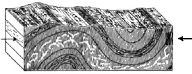
Fig. 176. Slaty Cleavage
We find additional proof that slates have undergone compression at right angles to their cleavage in the fact that any inclusions in them, such as nodules and fossils, have been squeezed out of shape and have their long diameters lying in the planes of cleavage.
That pressure is competent to cause cleavage is shown by experiment. Homogeneous material of fine grain, such as beeswax, when subjected to heavy pressure cleaves at right angles to the direction of the compressing force.
Rate of folding. All the facts known with regard to rock deformation agree that it is a secular process, taking place so slowly that, like the deepening of valleys by erosion, it escapes the notice of the inhabitants of the region. It is only under stresses slowly applied that rocks bend without breaking. The folds of some of the highest mountains have risen so gradually that strong, well-intrenched rivers which had the right of way across the region were able to hold to their courses, and as a circular saw cuts its way through the log which is steadily driven against it, so these rivers sawed their gorges through the fold as fast as it rose beneath them. Streams which thus maintain the course which they had antecedent to a deformation of the region are known as antecedent streams. Examples of such are the Sutlej and other rivers of India, whose valleys trench the outer ranges of the Himalayas and whose earlier river deposits have been upturned by the rising ridges. On the other hand, mountain crests are usually divides, parting the head waters of different drainage systems. In these cases the original streams of the region have been broken or destroyed by the uplift of the mountain mass across their paths.
On the whole, which have worked more rapidly, processes of deformation or of denudation?
Land Forms due to Folding
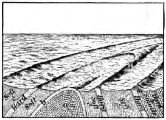
Fig. 177. An Unroofed Anticline
As folding goes on so slowly, it is never left to form surface features unmodified by the action of other agencies. An anticlinal fold is attacked by erosion as soon as it begins to rise above the original level, and the higher it is uplifted, and the stronger are its slopes, the faster is it worn away. Even while rising, a young upfold is often thus unroofed, and instead of appearing as a long, Smooth, boat-shaped ridge, it commonly has had opened along the rocks of the axis, when these are weak, a valley which is overlooked by the infacing escarpments of the hard layers of the sides of the fold (Fig. 177). Under long-continued erosion, anticlines may be degraded to valleys, while the synclines of the same system may be left in relief as ridges (Fig. 167).
Folded mountains. The vastness of the forces which wrinkle the crust is best realized in the presence of some lofty mountain range. All mountains, indeed, are not the result of folding. Some, as we shall see, are due to upwarps or to fractures of the crust; some are piles of volcanic material; some are swellings caused by the intrusion of molten matter beneath the surface; some are the relicts left after the long denudation of high plateaus.
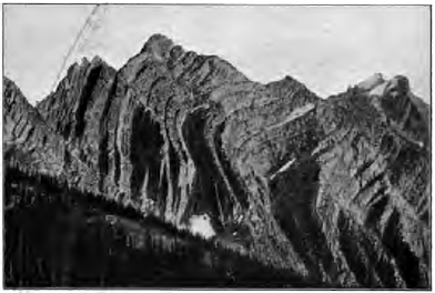
Fig. 178. Mountain Peaks carved in Folded Strata, Rocky Mountains, Montana
But most of the mountain ranges of the earth, and some of the greatest, such as the Alps and the Himalayas, were originally mountains of folding. The earth’s crust has wrinkled into a fold; or into a series of folds, forming a series of parallel ridges and intervening valleys; or a number of folds have been mashed together into a vast upswelling of the crust, in which the layers have been so crumpled and twisted, overturned and crushed, that it is exceedingly difficult to make out the original structure.
The close and intricate folds seen in great mountain ranges were formed, as we have seen, deep below the surface, within the zone of folding. Hence they may never have found expression in any individual surface features. As the result of these deformations deep under ground the surface was broadly lifted to mountain height, and the crumpled and twisted mountain structures are now to be seen only because erosion has swept away the heavy cover of surface rocks under whose load they were developed.
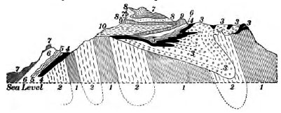
Fig. 179. Section of a Portion of the Alps
When the structure of mountains has been deciphered it is possible to estimate roughly the amount of horizontal compression which the region has suffered. If the strata of the folds of the Alps were smoothed out, they would occupy a belt seventy-four miles wider than that to which they have been compressed, or twice their present width. A section across the Appalachian folds in Pennsylvania shows a compression to about two thirds the original width; the belt has been shortened thirty-five miles in every hundred.
Considering the thickness of their strata, the compression which mountains have undergone accounts fully for their height, with enough to spare for all that has been lost by denudation.
The Appalachian folds involve strata thirty thousand feet in thickness. Assuming that the folded strata rested on an unyielding foundation, and that what was lost in width was gained in height, what elevation would the range have reached had not denudation worn it as it rose?
The life history of mountains. While the disturbance and uplift of mountain masses are due to deformation, their sculpture into ridges and peaks, valleys and deep ravines, and all the forms which meet the eye in mountain scenery, excepting in the very youngest ranges, is due solely to erosion. We may therefore classify mountains according to the degree to which they have been dissected. The Juras are an example of the stage of early youth, in which the anticlines still persist as ridges and the synclines coincide with the valleys; this they owe as much to the slight height of their uplift as to the recency of its date (Fig. 180).

Fig. 180. Section of a Portion of the Jura Mountains
The Alps were upheaved at various times (p. 399), the last uplift being later than the uplift of the Juras, but to so much greater height that erosion has already advanced them well on towards maturity. The mountain mass has been cut to the core, revealing strange contortions of strata which could never have found expression at the surface. Sharp peaks, knife-edged crests, deep valleys with ungraded slopes subject to frequent landslides, are all features of Alpine scenery typical of a mountain range at this stage in its life history. They represent the survival of the hardest rocks and the strongest structures, and the destruction of the weaker in their long struggle for existence against the agents of erosion. Although miles of rock have been removed from such ranges as the Alps, we need not suppose that they ever stood much, if any, higher than at present. All this vast denudation may easily have been accomplished while their slow upheaval was going on; in several mountain ranges we have evidence that elevation has not yet ceased.
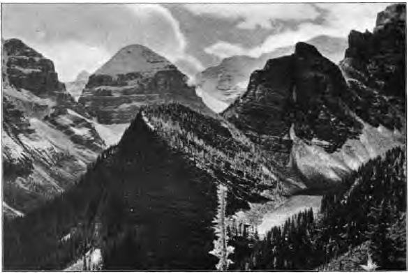
Fig. 181. Young Mountains, Rocky Mountains of Canada
Under long denudation mountains are subdued to the forms characteristic of old age. The lofty peaks and jagged crests of their earlier life are smoothed down to low domes and rounded crests. The southern Appalachians and portions of the Hartz Mountains in Germany (Fig. 182) are examples of mountains which have reached this stage.
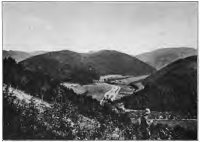
Fig. 182. Subdued Mountains, the Hartz Mountains, Germany
There are numerous regions of upland and plains in which the rocks are found to have the same structure that we have seen in folded mountains; they are tilted, crumpled, and overturned, and have clearly suffered intense compression. We may infer that their folds were once lifted to the height of mountains and have since been wasted to low-lying lands. Such a section as that of Figure 67 illustrates how ancient mountains may be leveled to their roots, and represents the final stage to which even the Alps and the Himalayas must sometime arrive. Mountains, perhaps of Alpine height, once stood about Lake Superior; a lofty range once extended from New England and New Jersey southwestward to Georgia along the Piedmont belt. In our study of historic geology we shall see more clearly how short is the life of mountains as the earth counts time, and how great ranges have been lifted, worn away, and again upheaved into a new cycle of erosion.
The sedimentary history of folded mountains. We may mention here some of the conditions which have commonly been antecedent to great foldings of the crust.
1. Mountain ranges are made of belts of enormously and exceptionally thick sediments. The strata of the Appalachians are thirty thousand feet thick, while the same formations thin out to five thousand feet in the Mississippi valley. The folds of the Wasatch Mountains involve strata thirty thousand feet thick, which thin to two thousand feet in the region of the Plains.
2. The sedimentary strata of which mountains are made are for the most part the shallow-water deposits of continental deltas. Mountain ranges have been upfolded along the margins of continents.
3. Shallow-water deposits of the immense thickness found in mountain ranges can be laid only in a gradually sinking area. A profound subsidence, often to be reckoned in tens of thousands of feet, precedes the upfolding of a mountain range.
Thus the history of mountains of folding is as follows: For long ages the sea bottom off the coast of a continent slowly subsides, and the great trough, as fast as it forms, is filled with sediments, which at last come to be many thousands of feet thick. The downward movement finally ceases. A slow but resistless pressure sets in, and gradually, and with a long series of many intermittent movements, the vast mass of accumulated sediments is crumpled and uplifted into a mountain range.
Fractures and Dislocations of the Crust
Considering the immense stresses to which the rocks of the crust are subjected, it is not surprising to find that they often yield by fracture, like brittle bodies, instead of by folding and flowing, like plastic solids. Whether rocks bend or break depends on the character and condition of the rocks, the load of overlying rocks which they bear, and the amount of the force and the slowness with which it is applied.
Joints. At the surface, where their load is least, we find rocks universally broken into blocks of greater or less size by partings known as joints. Under this name are included many division planes caused by cooling and drying; but it is now generally believed that the larger and more regular joints, especially those which run parallel to the dip and strike of the strata, are fractures due to up-and-down movements and foldings and twistings of the rocks.
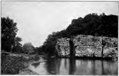
Fig. 183. Joints utilized by a River in widening its Valley, Iowa
Joints are used to great advantage in quarrying, and we have seen how they are utilized by the weather in breaking up rock masses, by rivers in widening their valleys, by the sea in driving back its cliffs, by glaciers in plucking their beds, and how they are enlarged in soluble rocks to form natural passageways for underground waters. The ends of the parted strata match along both sides of joint planes; in. joints there has been little or no displacement of the broken rocks.
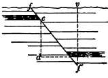
Fig. 184. A Normal Fault
Faults. In Figure 184 the rocks have been both broken and dislocated along the plane ff´. One side must have been moved up or down past the other. Such a dislocation is called a fault. The amount of the displacement, as measured by the vertical distance between the ends of a parted layer, is the throw (cd). The angle (ff´v) which the fault plane makes with the vertical is the hade. In Figure 184 the right side has gone down relatively to the left; the right is the side of the downthrow, while the left is the side of the upthrow. Where the fault plane is not vertical the surfaces on the two sides may be distinguished as the hanging wall (that on the right of Figure 184) and the foot wall (that on the left of the same figure). Faults differ in throw from a fraction of an inch to many thousands of feet.
Slickensides. If we examine the walls of a fault, we may find further evidence of movement in the fact that the surfaces are polished and grooved by the enormous friction which they have suffered as they have ground one upon the other. These appearances, called slickensides, have sometimes been mistaken for the results of glacial action.
Normal faults. Faults are of two kinds,—normal faults and thrust faults. Normal faults, of which Figure 184 is an example, hade to the downthrow; the hanging wall has gone down. The total length of the strata has been increased by the displacement. It seems that the strata have been stretched and broken, and that the blocks have readjusted themselves under the action of gravity as they settled.
Thrust faults. Thrust faults hade to the upthrow; the hanging wall has gone up. Clearly such faults, where the strata occupy less space than before, are due to lateral thrust. Folds and thrust faults are closely associated. Under lateral pressure strata may fold to a certain point and then tear apart and fault along the surface of least resistance. Under immense pressure strata also break by shear without folding. Thus, in Figure 185, the rigid earth block under lateral thrust has found it easier to break along the fault plane than to fold. Where such faults are nearly horizontal they are distinguished as thrust planes.
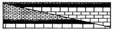
Fig. 185. A Thrust Fault
In all thrust faults one mass has been pushed over another, so as to bring the underlying and older strata upon younger beds; and when the fault planes are nearly horizontal, and especially when the rocks have been broken into many slices which have slidden far one upon another, the true succession of strata is extremely hard to decipher.
In the Selkirk Mountains of Canada the basement rocks of the region have been driven east for seven miles on a thrust plane, over rocks which originally lay thousands of feet above them.
Along the western Appalachians, from Virginia to Georgia, the mountain folds are broken by more than fifteen parallel thrust planes, running from northeast to southwest, along which the older strata have been pushed westward over the younger. The longest continuous fault has been traced three hundred and seventy-five miles, and the greatest horizontal displacement has been estimated at not less than eleven miles.
Crush breccia. Rocks often do not fault with a clean and simple fracture, but along a zone, sometimes several yards in width, in which they are broken to fragments. It may occur also that strata which as a whole yield to lateral thrust by folding include beds of brittle rocks, such as thin-layered limestones, which are crushed to pieces by the strain. In either case the fragments when recemented by percolating waters form a rock known as a crush breccia (pronounced bretcha)(Fig. 186).
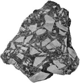
Fig. 186. Breccia
Breccia is a term applied to any rock formed of cemented angular fragments. This rock may be made by the consolidation of volcanic cinders, of angular waste at the foot of cliffs, or of fragments of coral torn by the waves from coral reefs, as well as of strata crushed by crustal movements.
Surface Features due to Dislocations
Fault scarps. A fault of recent date may be marked at surface by a scarp, because the face of the upthrown block has not yet been worn to the level of the downthrow side.
After the upthrown block has been worn down to this level, differential erosion produces fault scarps wherever weak rocks and resistant rocks are brought in contact along the fault plane; and the harder rocks, whether on the upthrow or the downthrow side, emerge in a line of cliffs. Where a fault is so old that no abrupt scarps appear, its general course is sometimes marked by the line of division between highland and lowland or hill and plain. Great faults have sometimes brought ancient crystalline rocks in contact with weaker and younger sedimentary rocks, and long after erosion has destroyed all fault scarps the harder crystallines rise in an upland of rugged or mountainous country which meets the lowland along the line of faulting.
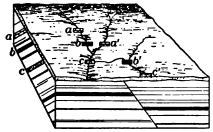
Fig. 187. A Concealed Fault This fault may be inferred from the changes in strata in passing along the strike, as from b to a´ and from c to b´
The vast majority of faults give rise to no surface features. The faulted region may be old enough to have been baseleveled, or the rocks on both sides of the line of dislocation may be alike in their resistance to erosion and therefore have been worn down to a common slope. The fault may be entirely concealed by the mantle of waste, and in such cases it can be inferred from abrupt changes in the character or the strike and dip of the strata where they may outcrop near it (Fig. 187).

Fig. 188. East-West Section across the Broken Plateau north of the Grand Canyon of the Colorado River, Arizona
The plateau trenched by the Grand Canyon of the Colorado River exhibits a series of magnificent fault scarps whose general course is from north to south, marking the edges of the great crust blocks into which the country has been broken. The highest part of the plateau is a crust block ninety miles long and thirty-five miles in maximum width, which has been hoisted to nine thousand three hundred feet above, sea level. On the east it descends four thousand feet by a monoclinal fold, which passes into a fault towards the north. On the west it breaks down by a succession of terraces faced by fault scarps. The throw of these faults varies from seven hundred feet to more than a mile. The escarpments, however, are due in a large degree to the erosion of weaker rock on the downthrow side.
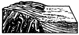
Fig. 189. The Fault separating the Highlands and the Lowlands, Scotland
The Highlands of Scotland (Fig. 189) meet the Lowlands on the south with a bold front of rugged hills along a line of dislocation which runs across the country from sea to sea. On the one side are hills of ancient crystalline rocks whose crumpled structures prove that they are but the roots of once lofty mountains; on the other lies a lowland of sandstone and other stratified rocks formed from the waste of those long-vanished mountain ranges. Remnants of sandstone occur in places on the north of the great fault, and are here seen to rest on the worn and fairly even surface of the crystallines. We may infer that these ancient mountains were reduced along their margins to low plains, which were slowly lowered beneath the sea to receive a cover of sedimentary rocks. Still later came an uplift and dislocation. On the one side erosion has since stripped off the sandstones for the most part, but the hard crystalline rocks yet stand in bold relief. On the other side the weak sedimentary rocks have been worn down to lowlands.
Rift valleys. In a broken region undergoing uplift or the unequal settling which may follow, a slice inclosed between two fissures may sink below the level of the crust blocks on either side, thus forming a linear depression known as a rift valley, or valley of fracture.
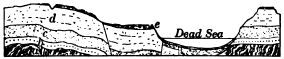
Fig. 190. Section from the Mountains of Palestine to the Mountains of Moab across the Dead Sea a, ancient schists; b, Carboniferous strata; c, d, and e, Cretaceous strata
One of the most striking examples of this rare type of valley is the long trough which runs straight from the Lebanon Mountains of Syria on the north to the Red Sea on the south, and whose central portion is occupied by the Jordan valley and the Dead Sea. The plateau which it gashes has been lifted more than three thousand feet above sea level, and the bottom of the trough reaches a depth of two thousand six hundred feet below that level in parts of the Dead Sea. South of the Dead Sea the floor of the trough rises somewhat above sea level, and in the Gulf of Akabah again sinks below it. This uneven floor could be accounted for either by the profound warping of a valley of erosion or by the unequal depression of the floor of a rift valley. But that the trough is a true valley of fracture is proved by the fact that on either side it is bounded by fault scarps and monoclinal folds. The keystone of the arch has subsided. Many geologists believe that the Jordan-Akabah trough, the long narrow basin of the Red Sea, and the chain of down-faulted valleys which in Africa extends from the strait of Bab-el-Mandeb as far south as Lake Nyassa—valleys which contain more than thirty lakes—belong to a single system of dislocation.
Should you expect the lateral valleys of a rift valley at the time of its formation to enter it as hanging valleys or at a common level?
Block mountains. Dislocations take place on so grand a scale that by the upheaval of blocks of the earth’s crust or the down- faulting of the blocks about one which is relatively stationary, mountains known as block mountains are produced. A tilted crust block may present a steep slope on the side upheaved and a more gentle descent on the side depressed.
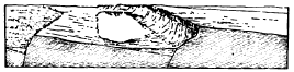
Fig. 191. Block Mountains, Southern Oregon
The Basin ranges. The plateaus of the United States bounded by the Rocky Mountains on the east, and on the west by the ranges which front the Pacific, have been profoundly fractured and faulted. The system of great fissures by which they are broken extends north and south, and the long, narrow, tilted crust blocks intercepted between the fissures give rise to the numerous north-south ranges of the region. Some of the tilted blocks, as those of southern Oregon, are as yet but moderately carved by erosion, and shallow lakes lie on the waste that has been washed into the depressions between them (Fig. 191). We may therefore conclude that their displacement is somewhat recent. Others, as those of Nevada, are so old that they have been deeply dissected; their original form has been destroyed by erosion, and the intermontane depressions are occupied by wide plains of waste.
Dislocations and river valleys. Before geologists had proved that rivers can by their own unaided efforts cut deep canyons, it was common to consider any narrow gorge as a gaping fissure of the crust. This crude view has long since been set aside. A map of the plateaus of northern Arizona shows how independent of the immense faults of the region is the course of the Colorado River. In the Alps the tunnels on the Saint Gotthard railway pass six times beneath the gorge of the Reuss, but at no point do the rocks show the slightest trace of a fault.
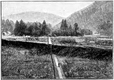
Fig. 192. Fault crossing Valley in Japan
Rate of dislocation. So far as human experience goes, the earth movements which we have just studied, some of which have produced deep-sunk valleys and lofty mountain ranges, and faults whose throw is to be measured in thousands of feet, are slow and gradual. They are not accomplished by a single paroxysmal effort, but by slow creep and a series of slight slips continued for vast lengths of time.
In the Aspen mining district in Colorado faulting is now going on at a comparatively rapid rate. Although no sudden slips take place, the creep of the rock along certain planes of faulting gradually bends out of shape the square-set timbers in horizontal drifts and has closed some vertical shafts by shifting the upper portion across the lower. Along one of the faults of this region it is estimated that there has been a movement of at least four hundred feet since the Glacial epoch. More conspicuous are the instances of active faulting by means of sudden slips. In 1891 there occurred along an old fault plane in Japan a slip which produced an earth rent traced for fifty miles (Fig. 192). The country on one side was depressed in places twenty feet below that on the other, and also shifted as much as thirteen feet horizontally in the direction of the fault line.
In 1872 a slip occurred for forty miles on the great line of dislocation which runs along the eastern base of the Sierra Nevada Mountains. In the Owens valley, California, the throw amounted to twenty-five feet in places, with a horizontal movement along the fault line of as much as eighteen feet. Both this slip and that in Japan just mentioned caused severe earthquakes.
For the sake of clearness we have described oscillations, foldings, and fractures of the crust as separate processes, each giving rise to its own peculiar surface features, but in nature earth movements are by no means so simple,—they are often implicated with one another: folds pass into faults; in a deformed region certain rocks have bent, while others under the same strain, but under different conditions of plasticity and load, have broken; folded mountains have been worn to their roots, and the peneplains to which they have been denuded have been upwarped to mountain height and afterwards dissected,—as in the case of the Allegheny ridges, the southern Carpathians, and other ranges, —or, as in the case of the Sierra Nevada Mountains, have been broken and uplifted as mountains of fracture.
Draw the following diagrams, being careful to show the direction in which the faulted blocks have moved, by the position of the two parts of some well-defined layer of limestone, sandstone, or shale, which occurs on each side of the fault plane, as in Figure 184.

Fig. 193
1. A normal fault with a hade of 15°, the original fault scarp remaining.
2. A normal fault with a hade of 50°, the original fault scarp worn away, showing cliffs caused by harder strata on the downthrow side.
3. A thrust fault with a hade of 30°, showing cliffs due to harder strata outcropping on the downthrow.
4. A thrust fault with a hade of 80°, with surface baseleveled.
5. In a region of normal faults a coal mine is being worked along the seam of coal AB (Fig. 193). At B it is found broken by a fault f which hades toward A. To find the seam again, should you advise tunneling up or down from B?
6. In a vertical shaft of a coal mine the same bed of coal is pierced twice at different levels because of a fault. Draw a diagram to show whether the fault is normal or a thrust.
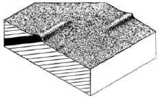
Fig. 194. Ridges to be explained by Faulting
7. Copy the diagram in Figure 194, showing how the two ridges may be accounted for by a single resistant stratum dislocated by a fault. Is the fault a strike fault, i.e. one running parallel with the strike of the strata, or a dip fault, one running parallel with the direction of the dip?
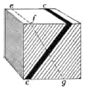
Fig. 195. Earth Block of Tilted Strata, with Included Seam of Coal cc
8. Draw a diagram of the block in Figure 195 as it would appear if dislocated along the plane efg by a normal fault whose throw equals one fourth the height of the block. Is the fault a strike or a dip fault? Draw a second diagram showing the same block after denudation has worn it down below the center of the upthrown side. Note that the outcrop of the coal seam is now deceptively repeated. This exercise may be done in blocks of wood instead of drawings.
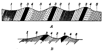
Fig. 196. A and B. Repeated Outcrops of Same Strata
9. Draw diagrams showing by dotted lines the conditions both of A and B, Figure 196, after deformation had given the strata their present attitude.
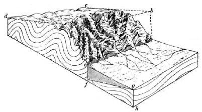
Fig. 197. A Block Mountain
10. What is the attitude of the strata of this earth block, Figure 197? What has taken place along the plane baf? When did the dislocation occur compared with the folding of the strata? With the erosion of the valleys on the right-hand side of the mountain? With the deposition of the sediments efg? Do you find any remnants of the original surface baf produced by the dislocation? From the left-hand side of the mountain infer what was the relief of the region before the dislocation. Give the complete history recorded in the diagram from the deposition of the strata to the present.
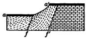
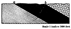
Fig. 198. A Faulted Lava Flow aa´ Fig. 199. Measurement of the Thickness of Inclined Strata
11. Which is the older fault, in Figure 198, f or f´? When did the lava flow occur? How long a time elapsed between the formation of the two faults as measured in the work done in the interval? How long a time since the formation of the later fault?
12. Measure by the scale the thickness bc of the coal-bearing strata outcropping from a to b in Figure 199. On any convenient scale draw a similar section of strata with a dip of 30° outcropping along a horizontal line normal to the strike one thousand feet in length, and measure the thickness of the strata by the scale employed. The thickness may also be calculated by trigonometry.
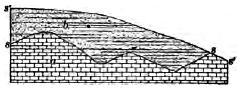
Fig. 200. Unconformity between Parallel Strata
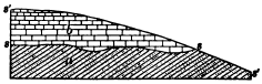
Fig. 201. Unconformity between Non-parallel Strata
Unconformity
Strata deposited one upon, another in an unbroken succession are said to be conformable. But the continuous deposition of strata is often interrupted by movements of the earth’s crust, Old sea floors are lifted to form land and are again depressed beneath the sea to receive a cover of sediments only after an interval during which they were carved by subaërial erosion. An erosion surface which thus parts older from younger strata is known as an unconformity, and the strata above it are said to be unconformable with the rocks below, or to rest unconformably upon them. An unconformity thus records movements of the crust and a consequent break in the deposition of the strata. It denotes a period of land erosion of greater or less length, which may sometimes be roughly measured by the stage in the erosion cycle which the land surface had attained before its burial. Unconformable strata may be parallel, as in Figure 200, where the record includes the deposition of strata a, their emergence, the erosion of the land surface ss, a submergence and the deposit of the strata b, and lastly, emergence and the erosion of the present surface s´s´.
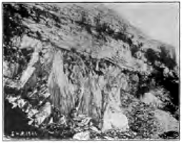
Fig. 202. Carboniferous Limestone resting unconformably on Early Silurian Slates, Yorkshire, England
Often the earth movements to which the uplift or depression was due involved tilting or folding of the earlier strata, so that the strata are now nonparallel as well as unconformable. In Figure 201, for example, the record includes deposition, uplift, and tilting of a; erosion, depression, the deposit of b; and finally the uplift which has brought the rocks to open air and permitted the dissection by which the unconformity is revealed.
From this section we infer that during early Silurian times the area was sea, and thick sea muds were laid upon it. These were later altered to hard slates by pressure and upfolded into mountains. During the later Silurian and the Devonian the area was land and suffered vast denudation. In the Carboniferous period it was lowered beneath the sea and received a cover of limestone.
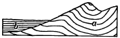
Fig. 203. Diagram Illustrating how the Age of Mountains is determined
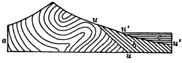
Fig. 204. Section of Mountain Range showing repeated Uplifts
a, strata whose folding formed a mountain range; uu, baseleveled surface produced by long denudation of the mountains; b, tilted strata resting unconformably on a; c, horizontal strata parted from b by the unconformity u´u´. The first uplift of the range preceded the period of time when b was deposited. The second uplift, to which the present mountains owe their height, was later than this period but earlier than the period when strata c were laid
The age of mountains. It is largely by means of unconformities that we read the history of mountain making and other deformations and movements of the crust. In Figure 203, for example, the deformation which upfolded the range of mountains took place after the deposit of the series of strata a of which the mountains are composed, and before the deposit of the stratified rocks b, which rest unconformably on a and have not shared their uplift.
Most great mountain ranges, like the Sierra Nevada and the Alps, mark lines of weakness along which the earth’s crust has yielded again and again during the long ages of geological time. The strata deposited at various times about their flanks have been infolded by later crumplings with the original mountain mass, and have been repeatedly crushed, inverted, faulted, intruded with igneous rocks, and denuded. The structure of great mountain ranges thus becomes exceedingly complex and difficult to read. A comparatively simple case of repeated uplift is shown in Figure 204. In the section of a portion of the Alps shown in Figure 179 a far more complicated history may be deciphered.
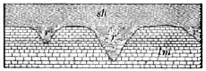
Fig. 205. Unconformity showing Buried Valleys
lm, limestone; sh, shale; r, r´, and r´´, river silts filling eroded valleys in the limestone. The upper surface of the limestone is evidently a land surface developed by erosion. The valleys which trench it are narrow and steep-sided; hence the land surface had not reached maturity. The sands and muds, now hardened to firm rock, which fill these valleys, r, r´, and r´´, contain no relics of the sea, but Instead the remains of land animals and plants. They are river deposits, and we may infer that owing to a subsidence the young rivers ceased to degrade their channels and slowly filled their gorges with sands and silts. The overlying shale records a further depression which brought the lanes below the level of the sea. A section similar to this is to be seen in the coal mines of Bernissant, Belgium, where a gorge twice as deep as that of Niagara was discovered within whose ancient river deposits were found entombed the skeletons of more than a score of the huge reptiles characteristic of the age when the gorge was cut and filled
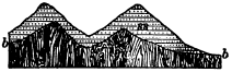
Fig. 206. Unconformity showing Buried Mountains, Scotland
gn, ancient crystalline rocks; ss, marine sandstones. The surface bb of the ancient crystalline rocks is mountainous, with peaks rising to a height of as much as three thousand feet. It is one of the most ancient land surfaces on the planet and is covered unconformably with pre-Cambrian sandstones thousands of feet in thickness, in which the Torridonian Mountains of Scotland have been carved. What has been the history of the region since the mountainous surface bb was produced by erosion?
Unconformities in the Colorado Canyon, Arizona. How geological history may be read in unconformities is further illustrated in Figures 207 and 208. The dark crystalline rocks a at the bottom of the canyon are among the most ancient known, and are overlain unconformably by a mass of tilted coarse marine sandstones b, whose total thickness is not seen in the diagram and measures twelve thousand feet perpendicularly to the dip. Both a and b rise to a common level nn´ and upon them rest the horizontal sea-laid strata c, in which the upper portion of the canyon has been cut.
Note that the crystalline rocks a have been crumpled and crushed. Comparing their structure with that of folded mountains, what do you infer as to their relief after their deformation? To which surface were they first worn down, mm´ or nm? Describe and account for the surface mm´. How does it differ from the surface of the crystalline rocks seen in the Torridonian Mountains (Fig. 206), and why? This surface mm´ is one of the oldest land surfaces of which any vestige remains. It is a bit of fossil geography buried from view since the earliest geological ages and recently brought to light by the erosion of the canyon.
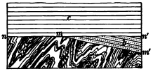
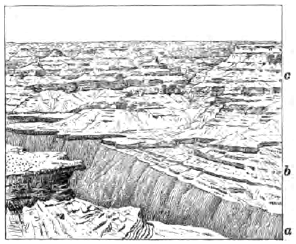
Fig. 207. Diagram of Wall of the Colorado Canyon, Arizona, showing Unconformities Fig. 208. View of the North Wall of the Grand Canyon of the Colorado River, Arizona, showing the Unconformities illustrated in Figure 207
How did the surface mm´ come to receive its cover of sandstones b? From the thickness and coarseness of these sediments draw inferences as to the land mass from which they were derived. Was it rising or subsiding? high or low? Were its streams slow or swift? Was the amount of erosion small or great?
Note the strong dip of these sandstones b. Was the surface mm´ tilted as now when the sandstones were deposited upon it? When was it tilted? Draw a diagram showing the attitude of the rocks after this tilting occurred, and their height relative to sea level.
The surface nn´ is remarkably even, although diversified by some low hills which rise into the bedded rocks of c, and it may be traced for long distances up and down the canyon. Were the layers of b and the surface mm´ always thus cut short by nn´ as now? What has made the surface nn´ so even? How does it come to cross the hard crystalline rocks a and the weaker sandstones b at the same impartial level? How did the sediments of c come to be laid upon it? Give now the entire history recorded in the section, and in addition that involved in the production of the platform P, shown in Figure 130, and that of the cutting of the canyon. How does the time involved in the cutting of the canyon compare with that required for the production of the surfaces mm´, nn´, and P?

Fig. 209. Unconformity between the Cambrian and Pre-Cambrian Rocks, Wisconsin
a, pre-Cambrian rocks, igneous and metamorphic, greatly deformed; a´, zone of decomposed pre-Cambrian rocks and residual clays on which rest the Cambrian sandstones b. What unconformity do you find here? What two peneplains do you discover? Which is the older? Which was the more complete? To what stage has the present erosion cycle advanced? Suggest a reason why the valleys in the Cambrian are wider than those in the pre- Cambrian. When did the decay of the pre-Cambrian rocks of zone a´ take place, and under what circumstances? Give the entire history recorded in this section, stating the successive cycles of erosion in their order and the causes which brought each cycle to a close
CHAPTER X
EARTHQUAKES
Any sudden movement of the rocks of the crust, as when they tear apart when a fissure is formed or extended, or slip from time to time along a growing fault, produces a jar called an earthquake, which spreads in all directions from the place of disturbance.
The Charleston earthquake. On the evening of August 31, 1886, the city of Charleston, S.C., was shaken by one of the greatest earthquakes which has occurred in the United States. A slight tremor which rattled the windows was followed a few seconds later by a roar, as of subterranean thunder, as the main shock passed beneath the city. Houses swayed to and fro, and their heaving floors overturned furniture and threw persons off their feet as, dizzy and nauseated, they rushed to the doors for safety. In sixty seconds a number of houses were completely wrecked, fourteen thousand chimneys were toppled over, and in all the city scarcely a building was left without serious injury. In the vicinity of Charleston railways were twisted and trains derailed. Fissures opened in the loose superficial deposits, and in places spouted water mingled with sand from shallow underlying aquifers.
The point of origin, or focus, of the earthquake was inferred from subsequent investigations to be a rent in the rocks about twelve miles beneath the surface. From the center of greatest disturbance, which lay above the focus, a few miles northwest of the city, the surface shock traveled outward in every direction, with decreasing effects, at the rate of nearly two hundred miles per minute. It was felt from Boston to Cuba, and from eastern Iowa to the Bermudas, over a circular area whose diameter was a thousand miles.
An earthquake is transmitted from the focus through the elastic rocks of the crust, as a wave, or series of waves, of compression and rarefaction, much as a sound wave is transmitted through the elastic medium of the air. Each earth particle vibrates with exceeding swiftness, but over a very short path. The swing of a particle in firm rock seldom exceeds one tenth of an inch in ordinary earthquakes, and when it reaches one half an inch and an inch, the movement becomes dangerous and destructive.
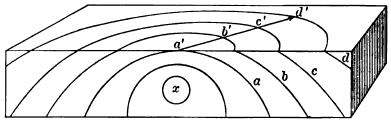
Fig. 210. Block of the Earth’s Crust shaken by an Earthquake x, focus; a, b, c, d, successive spheroidal waves in the crust; a´, b´, c´, d´, successive surface waves produced by the outcropping of a, b, c, and d
The velocity of earthquake waves, like that of all elastic waves, varies with the temperature and elasticity of the medium. In the deep, hot, elastic rocks they speed faster than in the cold and broken rocks near the surface. The deeper the point of origin and the more violent the initial shock, the faster and farther do the vibrations run.
Great earthquakes, caused by some sudden displacement or some violent rending of the rocks, shake the entire planet. Their waves run through the body of the earth at the rate of about three hundred and fifty miles a minute, and more slowly round its circumference, registering their arrival at opposite sides of the globe on the exceedingly delicate instruments of modern earthquake observatories.
Geological effects. Even great earthquakes seldom produce geological effects of much importance. Landslides may be shaken down from the sides of mountains and hills, and cracks may be opened in the surface deposits of plains; but the transient shiver, which may overturn cities and destroy thousands of human lives, runs through the crust and leaves it much the same as before.
The India earthquake of 1897. No earthquake of history has produced greater geological effects than that which shook northeastern India in 1897. It laid in ruins a region thrice the size of the state of New York. In places not a masonry building was left standing and hard-wood trees were snapped across. Foothills of the Himalayas were stripped of soil and forests from base to summit by landslides. Streams which before were busily cutting down their rocky beds were now overloaded with waste from the slides. They were compelled to cease eroding their beds while they spread their valleys deep with sand, over which they now flow in broad and shallow channels. The incoherent deposits of the alluvial plains were riddled with rents through which ground water was forced out in such quantities as to flood considerable areas.
Certain other effects often attributed to the earthquake are rather the manifestations of the dislocation to which the earthquake was due. Permanent changes of level were effected. Some hills were found to have been lifted twenty feet, while others were lowered, and resurveys proved that the entire region had been compressed horizontally from north to south. Displacements occurred along several fault lines. One of these, with a throw of twenty-five feet at the surface and a length of twelve miles, crossed a river repeatedly, causing a series of waterfalls and lakes. All these disturbances are best explained by the theory that the shock was due to a slip along a deep and hidden thrust plane, accompanied by other movements of the strata along minor faults connected with it, some of which reached the surface.
Earthquakes attending great displacements. Great earthquakes frequently attend the displacement of large masses of the rocks of the crust. In 1822 the coast of Chile was suddenly raised three or four feet, and the rise was five or six feet a mile inland. In 1835 the same region was again upheaved from two to ten feet. In each instance a destructive earthquake was felt for one thousand miles along the coast.
Perhaps the most violent earthquake which ever visited the United States attended the depression, in 1812, of a region seventy-five miles long and thirty miles wide, near New Madrid, Mo. Much of the area was converted into swamps and some into shallow lakes, while a region twenty miles in diameter was bulged up athwart the channel of the Mississippi. Slight quakes are still felt in this region from time to time, showing that the strains to which the dislocation was due have not yet been fully relieved.
Earthquakes originating beneath the sea. Many earthquakes originate beneath the sea, and in a number of examples they seem to have been accompanied, as soundings indicate, by local subsidences of the ocean bottom. There have been instances where the displacement has been sufficient to set the entire Pacific Ocean pulsating for many hours. In mid ocean the wave thus produced has a height of only a few feet, while it may be two hundred miles in width. On shores near the point of origin destructive waves two or three score feet in height roll in, and on coasts thousands of miles distant the expiring undulations may be still able to record themselves on tidal gauges.
Distribution of earthquakes. Every half hour some considerable area of the earth’s surface is sensibly shaken by an earthquake, but earthquakes are by no means uniformly distributed over the globe. As we might infer from what we know as to their causes, earthquakes are most frequent in regions now undergoing deformation. Such are young rising mountain ranges, fault lines where readjustments recur from time to time, and the slopes of suboceanic depressions whose steepness suggests that subsidence may there be in progress.
Earthquakes, often of extreme severity, frequently visit the lofty and young ranges of the Andes, while they are little known in the subdued old mountains of Brazil. The Highlands of Scotland are crossed by a deep and singularly straight depression called the Great Glen, which has been excavated along a very ancient line of dislocation. The earthquakes which occur from time to time in this region, such as the Inverness earthquake in 1891, are referred to slight slips along this fault plane.
In Japan, earthquakes are very frequent. More than a thousand are recorded every year, and twenty-nine world-shaking earthquakes occurred in the three years ending with 1901. They originate, for the most part, well down on the eastern flank of the earth fold whose summit is the mountainous crest of the islands, and which plunges steeply beneath the sea to the abyss of the Tuscarora Deep.