Front matter (continued 3)
Reading edition · Edition 2
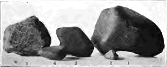
Fig. 88. Characteristic Pebbles from the Drift No. 1 has six facets; No. 4, originally a rounded river pebble, has been nibbled down to one flat face; Nos. 3 and 5 are battered subangular fragments on one side only
The stones of the drift are of many kinds. The region from which it was gathered may well have been large in order to supply these many different varieties of rocks. Pebbles and bowlders have been left far from their original homes, as may be seen in southern Iowa, where the drift contains nuggets of copper brought from the region about Lake Superior. The agent which laid the drift is one able to gather its load over a large area and carry it a long way.
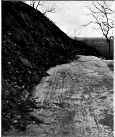
Fig. 89. Smoothed and Scored Rock Surface exposed to View by the Removal of Overlying Drift, Iowa
The pebbles of the drift are unlike those rounded by running water or by waves. They are marked with scratches. Some are angular, many have had their edges blunted, while others have been ground flat and smooth on one or more sides, like gems which have been faceted by being held firmly against the lapidary’s wheel (Fig. 88). In many places the upper surface of the country rock beneath the drift has been swept clean of residual clays and other waste. All rock rotten has been planed away, and the ledges of sound rock to which the surface has been cut down have been rubbed smooth and scratched with long, straight, parallel lines (Fig. 89). The agent which laid the drift can hold sand and pebbles firmly in its grasp and can grind them against the rock beneath, thus planing it down and scoring it, while faceting the pebbles also.
Neither water nor wind can do these things. Indeed, nothing like the drift is being formed by any process now at work anywhere in the eastern United States. To find the agent which has laid this extensive formation we must go to a region of different climatic conditions.
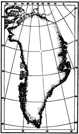
Fig. 90. Map of Greenland Glacier ice covers all but the areas shaded
The inland ice of Greenland. Greenland is about fifteen hundred miles long and nearly seven hundred miles in greatest width. With the exception of a narrow fringe of mountainous coast land, it is completely buried beneath a sheet of ice, in shape like a vast white shield, whose convex surface rises to a height of nine thousand feet above the sea. The few explorers who have crossed the ice cap found it a trackless desert destitute of all life save such lowly forms as the microscopic plant which produces the so- called “red snow.” On the smooth plain of the interior no rock waste relieves the snow’s dazzling whiteness; no streams of running water are seen; the silence is broken only by howling storm winds and the rustle of the surface snow which they drive before them. Sounding with long poles, explorers find that below the powdery snow of the latest snowfall lie successive layers of earlier snows, which grow more and more compact downward, and at last have altered to impenetrable ice. The ice cap formed by the accumulated snows of uncounted centuries may well be more than a mile in depth. Ice thus formed by the compacting of snow is distinguished when in motion as glacier ice.

Fig. 91. Hypothetical Cross Section of Greenland
The inland ice of Greenland moves. It flows with imperceptible slowness under its own weight, like, a mass of some viscous or plastic substance, such as pitch or molasses candy, in all directions outward toward the sea. Near the edge it has so thinned that mountain peaks are laid bare, these islands in the sea of ice being known as nunataks. Down the valleys of the coastal belt it drains in separate streams of ice, or glaciers. The largest of these reach the sea at the head of inlets, and are therefore called tide glaciers. Their fronts stand so deep in sea water that there is visible seldom more than three hundred feet of the wall of ice, which in many glaciers must be two thousand and more feet high. From the sea walls of tide glaciers great fragments break off and float away as icebergs. Thus snows which fell in the interior of this northern land, perhaps many thousands of years ago, are carried in the form of icebergs to melt at last in the North Atlantic.
Greenland, then, is being modeled over the vast extent of its interior not by streams of running water, as are regions in warm and humid climates, nor by currents of air, as are deserts to a large extent, but by a sheet of flowing ice. What the ice sheet is doing in the interior we may infer from a study of the separate glaciers into which it breaks at its edge.
The smaller Greenland glaciers. Many of the smaller glaciers of Greenland do not reach the sea, but deploy on plains of sand and gravel. The edges of these ice tongues are often as abrupt as if sliced away with a knife (Fig. 92), and their structure is thus readily seen. They are stratified, their layers representing in part the successive snowfalls of the interior of the country. The upper layers are commonly white and free from stones; but the lower layers, to the height of a hundred feet or more, are dark with débris which is being slowly carried on. So thickly studded with stones is the base of the ice that it is sometimes difficult to distinguish it from the rock waste which has been slowly dragged beneath the glacier or left about its edges. The waste beneath and about the glacier is unsorted. The stones are of many kinds, and numbers of them have been ground to flat faces. Where the front of the ice has retreated the rock surface is seen to be planed and scored in places by the stones frozen fast in the sole of the glacier.
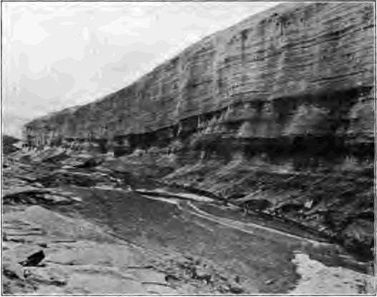
Fig. 92. A Greenland Glacier
We have now found in glacier ice an agent able to produce the drift of North America. The ice sheet of Greenland is now doing what we have seen was done in the recent past in our own land. It is carrying for long distances rocks of many kinds gathered, we may infer, over a large extent of country. It is laying down its load without assortment in unstratified deposits. It grinds down and scores the rock over which it moves, and in the process many of the pebbles of its load are themselves also ground smooth and scratched. Since this work can be done by no other agent, we must conclude that the northeastern part of our own continent was covered in the recent past by glacier ice, as Greenland is to-day.
Valley Glaciers
The work of glacier ice can be most conveniently studied in the separate ice streams which creep down mountain valleys in many regions such as Alaska, the western mountains of the United States and Canada, the Himalayas, and the Alps. As the glaciers of the Alps have been studied longer and more thoroughly than any others, we shall describe them in some detail as examples of valley glaciers in all parts of the world.
Conditions of glacier formation. The condition of the great accumulation of snow to which glaciers are due—that more or less of each winter’s snow should be left over unmelted and unevaporated to the next—is fully met in the Alps. There is abundant moisture brought by the winds from neighboring seas. The currents of moist air driven up the mountain slopes are cooled by their own expansion as they rise, and the moisture which they contain is condensed at a temperature at or below 32° F., and therefore is precipitated in the form of snow. The summers are cool and their heat does not suffice to completely melt the heavy snow of the preceding winter. On the Alps the snow line—the lower limit of permanent snow—is drawn at about eight thousand five hundred feet above sea level. Above the snow line on the slopes and crests, where these are not too steep, the snow lies the year round and gathers in valley heads to a depth of hundreds of feet.
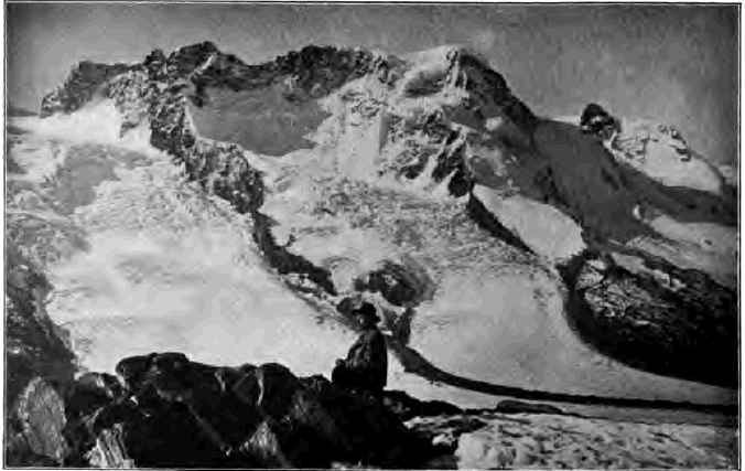
Fig. 93. Glaciers heading in Snow-filled Amphitheaters, the Alps
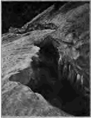
Fig. 94. Bergschrund of a Glacier in Colorado
This is but a small fraction of the thickness to which snow would be piled on the Alps were it not constantly being drained away. Below the snow fields which mantle the heights the mountain valleys are occupied by glaciers which extend as much as a vertical mile below the snow line. The presence in the midst of forests and meadows and cultivated fields of these tongues of ice, ever melting and yet from year to year losing none of their bulk, proves that their loss is made good in the only possible way. They are fed by snow fields above, whose surplus of snow they drain away in the form of ice. The presence of glaciers below the snow line is a clear proof that, rigid and motionless as they appear, glaciers really are in constant motion down valley.
The névé field. The head of an Alpine valley occupied by a glacier is commonly a broad amphitheater deeply filled with snow (Fig. 93). Great peaks tower above it, and snowy slopes rise on either side on the flanks of mountain spurs. From these heights fierce winds drift the snows into the amphitheater, and avalanches pour in their torrents of snow and waste. The snow of the amphitheater is like that of drifts in late winter after many successive thaws and freezings. It is made of hard grains and pellets and is called névé. Beneath the surface of the névé field and at its outlet the granular névé has been compacted to a mass of porous crystalline ice. Snow has been changed to névé, and névé to glacial ice, both by pressure, which drives the air from the interspaces of the snowflakes, and also by successive meltings and freezings, much as a snowball is packed in the warm hand and becomes frozen to a ball of ice.
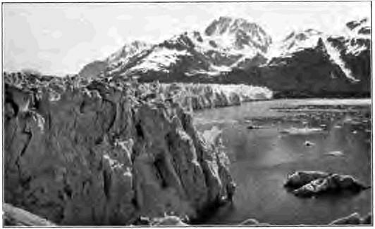
Fig. 95. Sea Wall of the Muir Glacier, Alaska
The bergschrund. The névé is in slow motion. It breaks itself loose from the thinner snows about it, too shallow to share its motion, and from the rock rim which surrounds it, forming a deep fissure called the bergschrund, sometimes a score and more feet wide (Fig. 94).
Size of glaciers. The ice streams of the Alps vary in size according to the amount of precipitation and the area of the névé fields which they drain. The largest of Alpine glaciers, the Aletsch, is nearly ten miles long and has an average width of about a mile. The thickness of some of the glaciers of the Alps is as much as a thousand feet. Giant glaciers more than twice the length of the longest in the Alps occur on the south slope of the Himalaya Mountains, which receive frequent precipitations of snow from moist winds from the Indian Ocean. The best known of the many immense glaciers of Alaska, the Muir, has an area of about eight hundred square miles (Fig. 95).
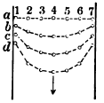
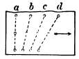
Fig. 96. Diagram showing Movement of Row of Stakes a, set in a direct line across the surface of a glacier; b, c, and d, successive later positions of the stakes Fig. 97. Diagram showing Movement of Vertical Row of Stakes a, set on side of glacier
Glacier motion. The motion of the glaciers of the Alps seldom exceeds one or two feet a day. Large glaciers, because of the enormous pressure of their weight and because of less marginal resistance, move faster than small ones. The Muir advances at the rate of seven feet a day, and some of the larger tide glaciers of Greenland are reported to move at the exceptional rate of fifty feet and more in the same time. Glaciers move faster by day than by night, and in summer than in winter. Other laws of glacier motion may be discovered by a study of Figures 96 and 97. It is important to remember that glaciers do not slide bodily over their beds, but urged by gravity move slowly down valley in somewhat the same way as would a stream of thick mud. Although small pieces of ice are brittle, the large mass of granular ice which composes a glacier acts as a viscous substance.
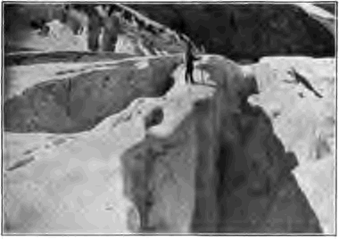
Fig. 98. Crevasses of a Glacier, Canada
Crevasses. Slight changes of slope in the glacier bed, and the different rates of motion in different parts, produce tensions under which the ice cracks and opens in great fissures called crevasses. At an abrupt descent in the bed the ice is shattered into great fragments, which unite again below the icefall. Crevasses are opened on lines at right angles to the direction of the tension. Transverse crevasses are due to a convexity in the bed which stretches the ice lengthwise (Fig. 99). Marginal crevasses are directed upstream and inwards; radial crevasses are found where the ice stream deploys from some narrow valley and spreads upon some more open space. What is the direction of the tension which causes each and to what is it due? (Figs. 100 and 101.
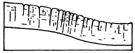
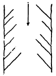
Fig. 99. Longitudinal Section of a Portion of a Glacier, showing Traverse Crevasses Fig. 100. Map view of Marginal Crevasses
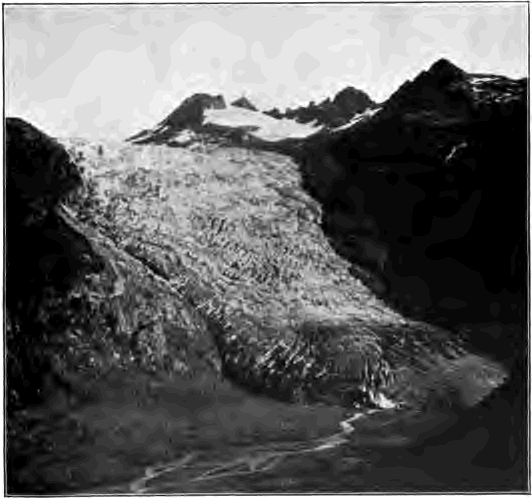
Fig. 101. The Rhone Glacier, showing Radial Crevasses, the Alps
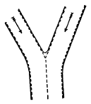
Fig. 102. Map View of the Junction of Two Branches of a Glacier
The moraines are represented by broken lines
Lateral and medial moraines. The surface of a glacier is striped lengthwise by long dark bands of rock débris. Those in the center are called the medial moraines. The one on either margin is a lateral moraine, and is clearly formed of waste which has fallen on the edge of the ice from the valley slopes. A medial moraine cannot be formed in this way, since no rock fragments can fall so far out from the sides. But following it up the glacial stream, one finds that a medial moraine takes its beginning at the junction of the glacier and some tributary and is formed by the union of their two adjacent lateral moraines (Fig. 102). Each branch thus adds a medial moraine, and by counting the number of medial moraines of a trunk stream one may learn of how many branches it is composed.
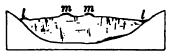
Fig. 103. Cross Section of a Glacier showing Lateral Moraines l, l, and Medial Moraines m, m
Surface moraines appear in the lower course of the glacier as ridges, which may reach the exceptional height of one hundred feet. The bulk of such a ridge is ice. It has been protected from the sun by the veneer of moraine stuff; while the glacier surface on either side has melted down at least the distance of the height of the ridge. In summer the lowering of the glacial surface by melting goes on rapidly. In Swiss glaciers it has been estimated that the average lowering of the surface by melting and evaporation amounts to ten feet a year. As a moraine ridge grows higher and more steep by the lowering of the surface of the surrounding ice, the stones of its cover tend to slip down its sides. Thus moraines broaden, until near the terminus of a glacier they may coalesce in a wide field of stony waste.
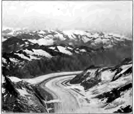
Fig. 104. Glacier with Medial Moraines, the Alps Is the ice moving from or towards the observer?
Englacial drift. This name is applied to whatever débris is carried within the glacier. It consists of rock waste fallen on the névé and there buried by accumulations of snow, and of that engulfed in the glacier where crevasses have opened beneath a surface moraine. As the surface of the glacier is lowered by melting, more or less englacial drift is brought again to open air, and near the terminus it may help to bury the ice from view beneath a sheet of débris.
The ground moraine. The drift dragged along at the glacier’s base and lodged beneath it is known as the ground moraine. Part of the material of it has fallen down deep crevasses and part has been torn and worn from the glacier’s bed and banks. While the stones of the surface moraines remain as angular as when they lodged on the ice, many of those of the ground moraine have been blunted on the edges and faceted and scratched by being ground against one another and the rocky bed.
In glaciers such as those of Greenland, whose basal layers are well loaded with drift and whose surface layers are nearly clean, different layers have different rates of motion, according to the amount of drift with which they are clogged. One layer glides over another, and the stones inset in each are ground and smoothed and scratched. Usually the sides of glaciated pebbles are more worn than the ends, and the scratches upon them run with the longer axis of the stone. Why?
The terminal moraine. As a glacier is in constant motion, it brings to its end all of its load except such parts of the ground moraine as may find permanent lodgment beneath the ice. Where the glacier front remains for some time at one place, there is formed an accumulation of drift known as the terminal moraine. In valley glaciers it is shaped by the ice front to a crescent whose convex side is downstream. Some of the pebbles of the terminal moraine are angular, and some are faceted and scored, the latter having come by the hard road of the ground moraine. The material of the dump is for the most part unsorted, though the water of the melting ice may find opportunity to leave patches of stratified sands and gravels in the midst of the unstratified mass of drift, and the finer material is in places washed away.
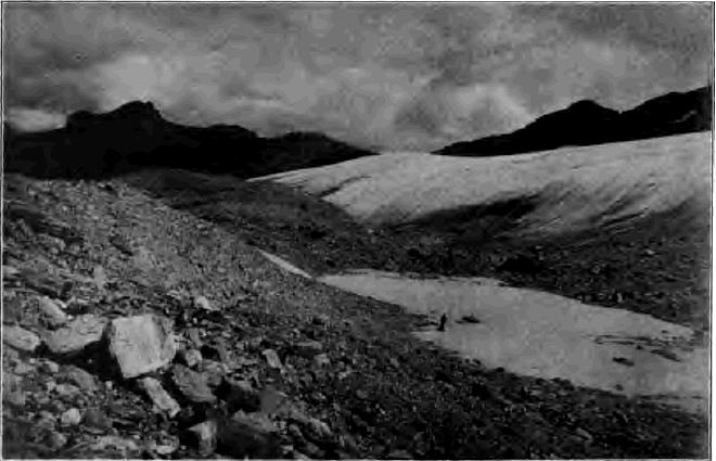
Fig. 105. Terminal Moraine of a Glacier in Montana
The ice has melted back from the morainic ridge on the left and is building another on the right. The hollow between the ridges is occupied by a lakelet.
Glacier drainage. The terminal moraine is commonly breached by a considerable stream, which issues from beneath the ice by a tunnel whose portal has been enlarged to a beautiful archway by melting in the sun and the warm air (Fig. 107). The stream is gray with silt and loaded with sand and gravel washed from the ground moraine. “Glacier milk” the Swiss call this muddy water, the gray color of whose silt proves it rock flour freshly ground by the ice from the unoxidized sound rock of its bed, the mud of streams being yellowish when it is washed from the oxidized mantle of waste. Since glacial streams are well loaded with waste due to vigorous ice erosion, the valley in front of the glacier is commonly aggraded to a broad, flat floor. These outwash deposits are known as valley drift.
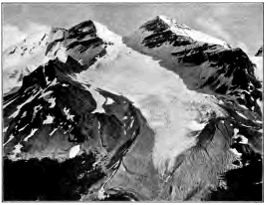
Fig. 106. Heavy Moraine about the Terminus of a Glacier in the Rocky Mountains of Canada Account for the fact that the morainic ridge rises considerably above the surface of the ice
The sand brought out by streams from beneath a glacier differs from river sand in that it consists of freshly broken angular grains. Why?
The stream derives its water chiefly from the surface melting of the glacier. As the ice is touched by the rays of the morning sun in summer, water gathers in pools, and rills trickle and unite in brooklets which melt and cut shallow channels in the blue ice. The course of these streams is short. Soon they plunge into deep wells cut by their whirling waters where some crevasse has begun to open across their path. These wells lead into chambers and tunnels by which sooner or later their waters find way to the rock floor of the valley and there unite in a subglacial stream.
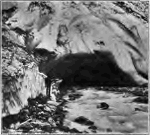
Fig. 107. Subglacial Stream Issuing from Tunnel in the Ice, Norway
The lower limit of glaciers. The glaciers of a region do not by any means end at a uniform height above sea level. Each terminates where its supply is balanced by melting. Those therefore which are fed by the largest and deepest névés and those also which are best protected from the sun by a northward exposure or by the depth of their inclosing valleys flow to lower levels than those whose supply is less and whose exposure to the sun is greater.
A series of cold, moist years, with an abundant snowfall, causes glaciers to thicken and advance; a series of warm, dry years causes them to wither and melt back. The variation in glaciers is now carefully observed in many parts of the world. The Muir glacier has retreated two miles in twenty years. The glaciers of the Swiss Alps are now for the most part melting back, although a well-known glacier of the eastern Alps, the Vernagt, advanced five hundred feet in the year 1900, and was then plowing up its terminal moraine.
How soon would you expect a glacier to advance after its névé fields have been swollen with unusually heavy snows, as compared with the time needed for the flood of a large river to reach its mouth after heavy rains upon its headwaters?
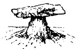
Fig. 108. A Glacier Table
On the surface of glaciers in summer time one may often see large stones supported by pillars of ice several feet in height (Fig. 108). These “glacier tables” commonly slope more or less strongly to the south, and thus may be used to indicate roughly the points of the compass. Can you explain their formation and the direction of their slope? On the other hand, a small and thin stone, or a patch of dust, lying on the ice, tends to sink a few inches into it. Why?
In what respects is a valley glacier like a mountain stream which flows out upon desert plains?
Two confluent glaciers do not mingle their currents as do two confluent rivers. What characteristics of surface moraines prove this fact?
What effect would you expect the laws of glacier motion to have on the slant of the sides of transverse crevasses?
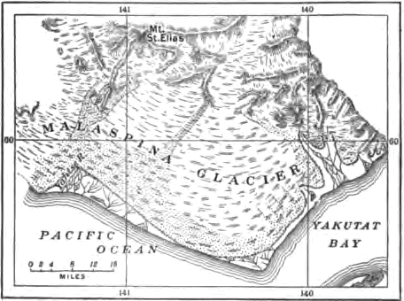
Fig. 109. Map of Malaspina Glacier, Alaska
A trunk glacier has four medial moraines. Of how many tributaries is it composed? Illustrate by diagram.
State all the evidences which you have found that glaciers move.
If a glacier melts back with occasional pauses up a valley, what records are left of its retreat?
Piedmont Glaciers
The Malaspina glacier. Piedmont (foot of the mountain) glaciers are, as the name implies, ice fields formed at the foot of mountains by the confluence of valley glaciers. The Malaspina glacier of Alaska, the typical glacier of this kind, is seventy miles wide and stretches for thirty miles from the foot of the Mount Saint Elias range to the shore of the Pacific Ocean. The valley glaciers which unite and spread to form this lake of ice lie above the snow line and their moraines are concealed beneath névé. The central area of the Malaspina is also free from débris; but on the outer edge large quantities of englacial drift are exposed by surface melting and form a belt of morainic waste a few feet thick and several miles wide, covered in part with a luxuriant forest, beneath which the ice is in places one thousand feet in depth. The glacier here is practically stagnant, and lakes a few hundred yards across, which could not exist were the ice in motion and broken with crevasses, gather on their beds sorted waste from the moraine. The streams which drain the glacier have cut their courses in englacial and subglacial tunnels; none flow for any distance on the surface. The largest, the Yahtse River, issues from a high archway in the ice,—a muddy torrent one hundred feet wide and twenty feet deep, loaded with sand and stones which it deposits in a broad outwash plain (Fig. 110). Where the ice has retreated from the sea there is left a hummocky drift sheet with hollows filled with lakelets. These deposits help to explain similar hummocky regions of drift and similar plains of coarse, water-laid material often found in the drift-covered area of the northeastern United States.
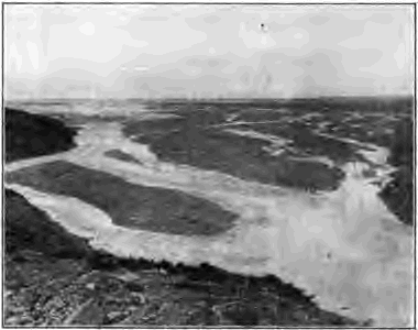
Fig. 110. Outwash Plain, the Delta of the Yahtse River, Alaska
The Geological Work Of Glacier Ice
The sluggish glacier must do its work in a different way from the agile river. The mountain stream is swift and small, and its channel occupies but a small portion of the valley. The glacier is slow and big; its rate of motion may be less than a millionth of that of running water over the same declivity, and its bulk is proportionately large and fills the valley to great depth. Moreover, glacier ice is a solid body plastic under slowly applied stresses, while the water of rivers is a nimble fluid.
Transportation. Valley glaciers differ from rivers as carriers in that they float the major part of their load upon their surface, transporting the heaviest bowlder as easily as a grain of sand; while streams push and roll much of their load along their beds, and their power of transporting waste depends solely upon their velocity. The amount of the surface load of glaciers is limited only by the amount of waste received from the mountain slopes above them. The moving floor of ice stretched high across a valley sweeps along as lateral moraines much of the waste which a mountain stream would let accumulate in talus and alluvial cones.
While a valley glacier carries much of its load on top, an ice sheet, such as that of Greenland, is free from surface débris, except where moraines trail away from some nunatak. If at its edge it breaks into separate glaciers which drain down mountain valleys, these tongues of ice will carry the selvages of waste common to valley glaciers. Both ice sheets and valley glaciers drag on large quantities of rock waste in their ground moraines.
Stones transported by glaciers are sometimes called erratics. Such are the bowlders of the drift of our northern states. Erratics may be set down in an insecure position on the melting of the ice.
Deposit. Little need be added here to what has already been said of ground and terminal moraines. All strictly glacial deposits are unstratified. The load laid down at the end of a glacier in the terminal moraine is loose in texture, while the drift lodged beneath the glacier as ground moraine is often an extremely dense, stony clay, having been compacted under the pressure of the overriding ice.
Erosion. A glacier erodes its bed and banks in two ways,—by abrasion and by plucking.
The rock bed over which a glacier has moved is seen in places to have been abraded, or ground away, to smooth surfaces which are marked by long, straight, parallel scorings aligned with the line of movement of the ice and varying in size from hair lines and coarse scratches to exceptional furrows several feet deep. Clearly this work has been accomplished by means of the sharp sand, the pebbles, and the larger stones with which the base of the glacier is inset, and which it holds in a firm grasp as running water cannot. Hard and fine-grained rocks, such as granite and quartzite, are often not only ground down to a smooth surface but are also highly polished by means of fine rock flour worn from the glacier bed.
In other places the bed of the glacier is rough and torn. The rocks have been disrupted and their fragments have been carried away,—a process known as plucking. Moving under immense pressure the ice shatters the rock, breaks off projections, presses into crevices and wedges the rocks apart, dislodges the blocks into which the rock is divided by joints and bedding planes, and freezing fast to the fragments drags them on. In this work the freezing and thawing of subglacial waters in any cracks and crevices of the rock no doubt play an important part. Plucking occurs especially where the bed rock is weak because of close jointing. The product of plucking is bowlders, while the product of abrasion is fine rock flour and sand.
Is the ground moraine of Figure 87 due chiefly to abrasion or to plucking?
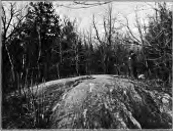
Fig. 111. Roches Mountonnés, Bronx Park, New York
Roches moutonnées and rounded hills. The prominences left between the hollows due to plucking are commonly ground down and rounded on the stoss side,—the side from which the ice advances,—and sometimes on the opposite, the lee side, as well. In this way the bed rock often comes to have a billowy surface known as roches moutonnées (sheep rocks). Hills overridden by an ice sheet often have similarly rounded contours on the stoss side, while on the lee side they may be craggy, either because of plucking or because here they have been less worn from their initial profile (Fig. 112).
The direction of glacier movement. The direction of the flow of vanished glaciers and ice sheets is recorded both in the differences just mentioned in the profiles of overridden hills and also in the minute details of the glacier trail.
Flint nodules or other small prominences in the bed rock are found more worn on the stoss than on the lee side, where indeed they may have a low cone of rock protected by them from abrasion. Cavities, on the other hand, have their edges worn on the lee side and left sharp upon the stoss.
Surfaces worn and torn in the ways which we have mentioned are said to be glaciated. But it must not be supposed that a glacier everywhere glaciates its bed. Although in places it acts as a rasp or as a pick, in others, and especially where its pressure is least, as near the terminus, it moves over its bed in the manner of a sled. Instances are known where glaciers have advanced over deposits of sand and gravel without disturbing them to any notable degree. Like a river, a glacier does not everywhere erode. In places it leaves its bed undisturbed and in places aggrades it by deposits of the ground moraine.
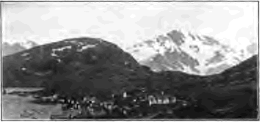
Fig. 112. A Glaciated Hill, Norway. Sharp Weathered Mountain Peaks in the Distance
Cirques. Valley glaciers commonly head as we have seen, in broad amphitheaters deeply filled with snow and ice. On mountains now destitute of glaciers, but whose glaciation shows that they have supported glaciers in the past, there are found similar crescentic hollows with high, precipitous walls and glaciated floors. Their floors are often basined and hold lakelets whose deep and quiet waters reflect the sheltering ramparts of rugged rock which tower far above them. Such mountain hollows are termed cirques. As a powerful spring wears back a recess in the valley side where it discharges, so the fountain head of a glacier gradually wears back a cirque. In its slow movement the névé field broadly scours its bed to a flat or basined floor. Meanwhile the sides of the valley head are steepened and driven back to precipitous walls. For in winter the crevasse of the bergschrund which surrounds the névé field is filled with snow and the névé is frozen fast to the rocky sides of the valley. In early summer the névé tears itself free, dislodging and removing any loosened blocks, and the open fissure of the bergschrund allows frost and other agencies of weathering to attack the unprotected rock. As cirques are thus formed and enlarged the peaks beneath which they lie are sharpened, and the mountain crests are scalloped and cut back from either side to knife-edged ridges (Figs. 113 and 93).
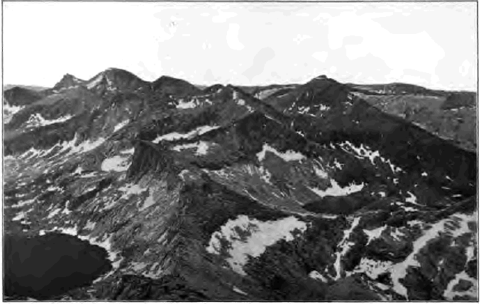
Fig. 113. Cirques, Sierra Nevada Mountains
In the western mountains of the United States many cirques, now empty of névé and glacier ice, and known locally as “basins,” testify to the fact that in recent times the snow line stood beneath the levels of their floors, and thus far below its present altitude.
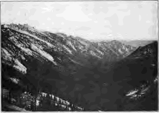
Fig. 114. A Glacier Trough, Montana
Glacier troughs. The channel worn to accommodate the big and clumsy glacier differs markedly from the river valley cut as with a saw by the narrow and flexible stream and widened by the weather and the wash of rains. The valley glacier may easily be from one thousand to three thousand feet deep and from one to three miles wide. Such a ponderous bulk of slowly moving ice does not readily adapt itself to sharp turns and a narrow bed. By scouring and plucking all resisting edges it develops a fitting channel with a wide, flat floor, and steep, smooth sides, above which are seen the weathered slopes of stream-worn mountain valleys. Since the trunk glacier requires a deeper channel than do its branches, the bed of a branch glacier enters the main trough at some distance above the floor of the latter, although the surface of the two ice streams may be accordant. Glacier troughs can be studied best where large glaciers have recently melted completely away, as is the case in many valleys of the mountains of the western United States and of central and northern Europe (Fig. 114). The typical glacier trough, as shown in such examples, is U-shaped, with a broad, flat floor, and high, steep walls. Its walls are little broken by projecting spurs and lateral ravines. It is as if a V-valley cut by a river had afterwards been gouged deeper with a gigantic chisel, widening the floor to the width of the chisel blade, cutting back the spurs, and smoothing and steepening the sides. A river valley could only be as wide-floored as this after it had long been worn down to grade.
The floor of a glacier trough may not be graded; it is often interrupted by irregular steps perhaps hundreds and even a thousand feet in height, over which the stream that now drains the valley tumbles in waterfalls. Reaches between the steps are often basined. Lakelets may occupy hollows excavated in solid rock, and other lakes may be held behind terminal moraines left as dams across the valley at pauses in the retreat of the glacier.
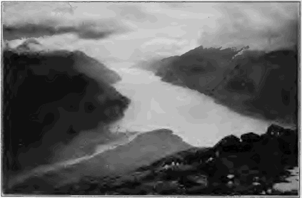
Fig. 115 Lynn Canal, Alaska, a Fjord
Fjords are glacier troughs now occupied in part or wholly by the sea, either because they were excavated by a tide glacier to their present depth below sea level, or because of a submergence of the land. Their characteristic form is that of a long, deep, narrow bay with steep rock walls and basined floor (Fig. 115). Fjords are found only in regions which have suffered glaciation, such as Norway and Alaska.
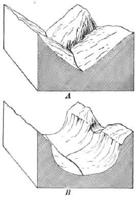
Fig. 116. A, V-River Valley, with Valley of Tributary joining it a Accordant Level; B, the Same changed after Long Glaciation to a Trough with Hanging Valley
Hanging valleys. These are lateral valleys which open on their main valley some distance above its floor. They are conspicuous features of glacier troughs from which the ice has vanished; for the trunk glacier in widening and deepening its channel cut its bed below the bottoms of the lateral valleys (Fig. 116).
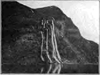
Fig. 117. Hanging Valley on the Wall of a Fjord, Norway
Since the mouths of hanging valleys are suspended on the walls of the glacier trough, their streams are compelled to plunge down its steep, high sides in waterfalls. Some of the loftiest and most beautiful waterfalls of the world leap from hanging valleys,—among them the celebrated Staubbach of the Lauterbrunnen valley of Switzerland, and those of the fjords of Norway and Alaska (Fig. 117).
Hanging valleys are found also in river gorges where the smaller tributaries have not been able to keep pace with a strong master stream in cutting down their beds. In this case, however, they are a mark of extreme youth; for, as the trunk stream approaches grade and its velocity and power to erode its bed decrease, the side streams soon cut back their falls and wear their beds at their mouths to a common level with that of the main river. The Grand Canyon of the Colorado must be reckoned a young valley. At its base it narrows to scarcely more than the width of the river, and yet its tributaries, except the very smallest, enter it at a common level.
Why could not a wide-floored valley, such as a glacier trough, with hanging valleys opening upon it, be produced in the normal development of a river valley?
The troughs of young and of mature glaciers. The features of a glacier trough depend much on the length of time the preexisting valley was occupied with ice. During the infancy of a glacier, we may believe, the spurs of the valley which it fills are but little blunted and its bed is but little broken by steps. In youth the glacier develops icefalls, as a river in youth develops waterfalls, and its bed becomes terraced with great stairs. The mature glacier, like the mature river, has effaced its falls and smoothed its bed to grade. It has also worn back the projecting spurs of its valley, making itself a wide channel with smooth sides. The bed of a mature glacier may form a long basin, since it abrades most in its upper and middle course, where its weight and motion are the greatest. Near the terminus, where weight and motion are the least, it erodes least, and may instead deposit a sheet of ground moraine, much as a river builds a flood plain in the same part of its course as it approaches maturity. The bed of a mature glacier thus tends to take the form of a long, relatively narrow basin, across whose lower end may be stretched the dam of the terminal moraine. On the disappearance of the ice the basin is rilled with a long, narrow lake, such as Lake Chelan in Washington and many of the lakes in the Highlands of Scotland.
Piedmont glaciers apparently erode but little. Beneath their lake- like expanse of sluggish or stagnant ice a broad sheet of ground moraine is probably being deposited.
Cirques and glaciated valleys rapidly lose their characteristic forms after the ice has withdrawn. The weather destroys all smoothed, polished, and scored surfaces which are not protected beneath glacial deposits. The oversteepened sides of the trough are graded by landslips, by talus slopes, and by alluvial cones. Morainic heaps of drift are dissected and carried away. Hanging valleys and the irregular bed of the trough are both worn down to grade by the streams which now occupy them. The length of time since the retreat of the ice from a mountain valley may thus be estimated by the degree to which the destruction of the characteristic features of the glacier trough has been carried.
In Figure 104 what characteristics of a glacier trough do you notice? What inference do you draw as to the former thickness of the glacier?
Name all the evidences you would expect to find to prove the fact that in the recent geological past the valleys of the Alps contained far larger glaciers than at present, and that on the north of the Alps the ice streams united in a piedmont glacier which extended across the plains of Switzerland to the sides of the Jura Mountains.
The relative importance of glaciers and of rivers. Powerful as glaciers are, and marked as are the land forms which they produce, it is easy to exaggerate their geological importance as compared with rivers. Under present climatic conditions they are confined to lofty mountains or polar lands. Polar ice sheets are permanent only so long as the lands remain on which they rest. Mountain glaciers can stay only the brief time during which the ranges continue young and high. As lofty mountains, such as the Selkirks and the Alps, are lowered by frost and glacier ice, the snowfall will decrease, the line of permanent snow will rise, and as the mountain hollows in which snow may gather are worn beneath the snow line, the glaciers must disappear. Under present climatic conditions the work of glaciers is therefore both local and of short duration.
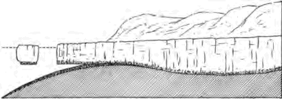
Fig. 118. Longitudinal Section of a Tide Glacier occupying a Fjord and discharging Icebergs Dotted Line, sea level
Even the glacial epoch, during which vast ice sheets deposited drift over northeastern North America, must have been brief as well as recent, for many lofty mountains, such as the Rockies and the Alps, still bear the marks of great glaciers which then filled their valleys. Had the glacial epoch been long, as the earth counts time, these mountains would have been worn low by ice; had the epoch been remote, the marks of glaciation would already have been largely destroyed by other agencies.
On the other hand, rivers are well-nigh universally at work over the land surfaces of the globe, and ever since the dry land appeared they have been constantly engaged in leveling the continents and in delivering to the seas the waste which there is built into the stratified rocks.
Icebergs. Tide glaciers, such as those of Greenland and Alaska, are able to excavate their beds to a considerable distance below sea level. From their fronts the buoyancy of sea water raises and breaks away great masses of ice which float out to sea as icebergs. Only about one seventh of a mass of glacier ice floats above the surface, and a berg three hundred feet high may be estimated to have been detached from a glacier not less than two thousand feet thick where it met the sea.
Icebergs transport on their long journeys whatever drift they may have carried when part of the glacier, and scatter it, as they melt, over the ocean floor. In this way pebbles torn by the inland ice from the rocks of the interior of Greenland and glaciated during their carriage in the ground moraine are dropped at last among the oozes of the bottom of the North Atlantic.
CHAPTER VI
THE WORK OF THE WIND
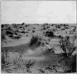
Fig. 119. A sandy Region in a Desert, the Sahara
We are now to study the geological work of the currents of the atmosphere, and to learn how they erode, and transport and deposit waste as they sweep over the land. Illustrations of the wind’s work are at hand in dry weather on any windy day. Clouds of dust are raised from the street and driven along by the gale. Here the roadway is swept bare; and there, in sheltered places, the dust settles in little windrows. The erosive power of waste-laden currents of air is suggested as the sharp grains of flying sand sting one’s face or clatter against the window. In the country one sometimes sees the dust whirled in clouds from dry, plowed fields in spring and left in the lee of fences in small drifts resembling in form those of snow in winter.
The essential conditions for the wind’s conspicuous work are illustrated in these simple examples; they are aridity and the absence of vegetation. In humid climates these conditions are only rarely and locally met; for the most part a thick growth of vegetation protects the moist soil from the wind with a cover of leaves and stems and a mattress of interlacing roots. But in arid regions either vegetation is wholly lacking, or scant growths are found huddled in detached clumps, leaving interspaces of unprotected ground (Fig. 119). Here, too, the mantle of waste, which is formed chiefly under the action of temperature changes, remains dry and loose for long periods. Little or no moisture is present to cause its particles to cohere, and they are therefore readily lifted and drifted by the wind.
Transportation By The Wind
In the desert the finer waste is continually swept to and fro by the ever-shifting wind. Even in quiet weather the air heated by contact with the hot sands rises in whirls, and the dust is lifted in stately columns, sometimes as much as one thousand feet in height, which march slowly across the plain. In storms the sand is driven along the ground in a continuous sheet, while the air is tilled with dust. Explorers tell of sand storms in the deserts of central Asia and Africa, in which the air grows murky and suffocating. Even at midday it may become dark as night, and nothing can be heard except the roar of the blast and the whir of myriads of grains of sand as they fly past the ear.
Sand storms are by no means uncommon in the arid regions of the western United States. In a recent year, six were reported from Yuma, Arizona. Trains on transcontinental railways are occasionally blockaded by drifting sand, and the dust sifts into closed passenger coaches, covering the seats and floors. After such a storm thirteen car loads of sand were removed from the platform of a station on a western railway.
Dust falls. Dust launched by upward-whirling winds on the swift currents of the upper air is often blown for hundreds of miles beyond the arid region from which it was taken. Dust falls from western storms are not unknown even as far east as the Great Lakes. In 1896 a “black snow” fell in Chicago, and in another dust storm in the same decade the amount of dust carried in the air over Rock Island, Ill., was estimated at more than one thousand tons to the cubic mile.
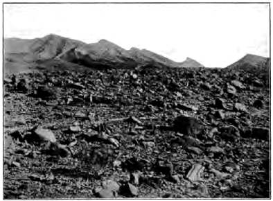
Fig. 120. A Tract of Rocky Desert, Arabia By what process have these rocks been broken up? Why is finer waste here absent?
In March, 1901, a cyclonic storm carried vast quantities of dust from the Sahara northward across the Mediterranean to fall over southern and central Europe. On March 8th dust storms raged in southern Algeria; two days later the dust fell in Italy; and on the 11th it had reached central Germany and Denmark. It is estimated that in these few days one million eight hundred thousand tons of waste were carried from northern Africa and deposited on European soil.
We may see from these examples the importance of the wind as an agent of transportation, and how vast in the aggregate are the loads which it carries. There are striking differences between air and water as carriers of waste. Rivers flow in fixed and narrow channels to definite goals. The channelless streams of the air sweep across broad areas, and, shifting about continually, carry their loads back and forth, now in one direction and now in another.
Wind Deposits
The mantle of waste of deserts is rapidly sorted by the wind. The coarser rubbish, too heavy to be lifted into the air, is left to strew wide tracts with residual gravels (Fig. 120). The sand derived from the disintegration of desert rocks gathers in vast fields. About one eighth of the surface of the Sahara is said to be thus covered with drifting sand. In desert mountains, as those of Sinai, it lies like fields of snow in the high valleys below the sharp peaks. On more level tracts it accumulates in seas of sand, sometimes, as in the deserts of Arabia, two hundred and more feet deep.
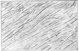
Fig. 121. Longitudinal Dunes, Desert of Northwestern India Scale, 1 in = 3 miles
Dunes. The sand thus accumulated by the wind is heaped in wavelike hills called dunes. In the desert of northwestern India, where the prevalent wind is of great strength, the sand is laid in longitudinal dunes, i.e. in stripes running parallel with the direction of the wind; but commonly dunes lie, like ripple marks, transverse to the wind current. On the windward side they show a long, gentle slope, up which grains of sand can readily be moved; while to the lee their slope is frequently as great as the angle of repose (Fig. 122). Dunes whose sands are not fixed by vegetation travel slowly with the wind; for their material is ever shifted forward as the grains are driven up the windward slope and, falling over the crest, are deposited in slanting layers in the quiet of the lee.
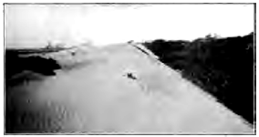
Fig. 122. A Transverse Dune, Seven Mile Beach, New Jersey
Account for the difference of slope in the two sides of the dune. Is the dune marching? In what direction? With what effect? Do the ridges of the ripple marks upon the dune extend along it or athwart it? Why?
Like river deposits, wind-blown sands are stratified, since they are laid by currents of air varying in intensity, and therefore in transporting power, which carry now finer and now coarser materials and lay them down where their velocity is checked (Fig. 123). Since the wind varies in direction, the strata dip in various directions. They also dip at various angles, according to the inclination of the surface on which they were laid.
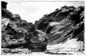
Fig. 123. Stratified Wind-Blown Sands, Bermuda Islands
These islands are made wholly of limestone, the product of reef-building corals, and of lime from the sea water. The limestone sand of the beaches has been blown up into great dunes, some more than two hundred feet in height. Much of the loose dune sand has been changed to firm rock by percolating waters, which have dissolved some of the limestone and deposited it again as a cement between the grains.
Dunes occur not only in arid regions, but also wherever loose sand lies unprotected by vegetation from the wind. From the beaches of sea and lake shores the wind drives inland the surface sand left dry between tides and after storms, piling it in dunes which may invade forests and fields and bury villages beneath their slowly advancing waves. On flood plains during summer droughts river deposits are often worked over by the wind; the sand is heaped in hummocks and much of the fine silt is caught and held by the forests and grassy fields of the bordering hills.

Fig. 124. Cross Section of Transverse Dune after Reversal of Wind
Redraw diagram, showing by dotted line the original outline of the dune
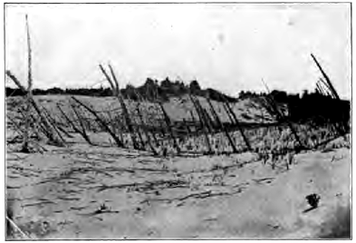
Fig. 125. Dune Sands, Shore of Lake Michigan
Account for the dead forest, for its leaning tree trunks. Is the lake shore to the right or left? What has been the history of the landscape?
The sand of shore dunes differs little in composition and the shape of its grains from that of the beach from which it was derived. But in deserts, by the long wear of grain on grain as they are blown hither and thither by the wind, all soft minerals are ground to powder and the sand comes to consist almost wholly of smooth round grams of hard quartz.
Some marine sandstones, such as the St. Peter sandstone of the upper Mississippi valley, are composed so entirely of polished spherules of quartz that it has been believed by some that their grains were long blown about in ancient deserts before they were deposited in the sea.
Dust deposits. As desert sands are composed almost wholly of quartz, we may ask what has become of the softer minerals of which the rocks whose disintegration has supplied the sand were in part, and often in large part, composed. The softer minerals have been ground to powder, and little by little the quartz sand also is worn by attrition to fine dust. Yet dust deposits are scant and few in great deserts such as the Sahara. The finer waste is blown beyond its limits and laid in adjacent oceans, where it adds to the muds and oozes of their floors, and on bordering steppes and forest lands, where it is bound fast by vegetation and slowly accumulates in deposits of unstratified loose yellow earth. The fine waste of the Sahara has been identified in dredgings from the bottom of the Atlantic Ocean, taken hundreds of miles from the coast of Africa.
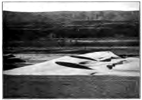
Fig. 126. Crescentic Sand Dunes, Valley of the Columbia River
Did the wind which shaped them blow from the left or from the right?
Loess. In northern China an area as large as France is deeply covered with a yellow pulverulent earth called loess (German, loose), which many consider a dust deposit blown from the great Mongolian desert lying to the west. Loess mantles the recently uplifted mountains to the height of eight thousand feet and descends on the plains nearly to sea level. Its texture and lack of stratification give it a vertical cleavage; hence it stands in steep cliffs on the sides of the deep and narrow trenches which have been cut in it by streams.
On loess hillsides in China are thousands of villages whose eavelike dwellings have been excavated in this soft, yet firm, dry loam. While dust falls are common at the present time in this region, the loess is now being rapidly denuded by streams, and its yellow silt gives name to the muddy Hwang-ho (Yellow River), and to the Yellow Sea, whose waters it discolors for scores of miles from shore.
Wind deposits both of dust and of sand may be expected to contain the remains of land shells, bits of wood, and bones of land animals, testifying to the fact that they were accumulated in open air and not in the sea or in bodies of fresh water.
Wind Erosion
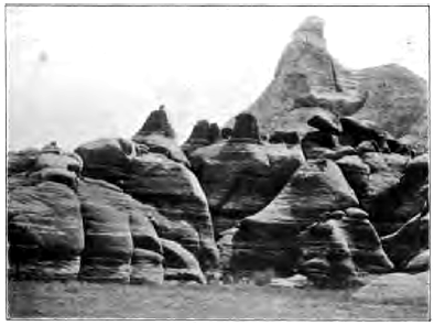
Fig. 127. Wind-Carved Rocks, Arizona
Sand-laden currents of air abrade and smooth and polish exposed rock surfaces, acting in much the same way as does the jet of steam fed with sharp sand, which is used in the manufacture of ground glass. Indeed, in a single storm at Cape Cod a plate glass of a lighthouse was so ground by flying sand that its transparency was destroyed and its removal made necessary.
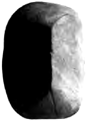
Fig. 128. A Wind-Carved Pebble, Cape Cod
Telegraph poles and wires whetted by wind-blown sands are destroyed within a few years. In rocks of unequal resistance the harder parts are left in relief, while the softer are etched away. Thus in the pass of San Bernardino, Cal., through which strong winds stream from the west, crystals of garnet are left projecting on delicate rock fingers from the softer rock in which they were imbedded.
Wind-carved pebbles are characteristically planed, the facets meeting along a summit ridge or at a point like that of a pyramid. We may suppose that these facets were ground by prevalent winds from certain directions, or that from time to time the stone was undermined and rolled over as the sand beneath it was blown away on the windward side, thus exposing fresh surfaces to the driving sand. Such wind-carved pebbles are sometimes found in ancient rocks and may be accepted as evidence that the sands of which the rocks are composed were blown about by the wind.
Deflation. In the denudation of an arid region, wind erosion is comparatively ineffective as compared with deflation (Latin, de, from; flare, to blow),—a term by which is meant the constant removal of waste by the wind, leaving the rocks bare to the continuous attack of the weather. In moist climates denudation is continually impeded by the mantle of waste and its cover of vegetation, and the land surface can be lowered no faster than the waste is removed by running water. Deep residual soils come to protect all regions of moderate slope, concealing from view the rock structure, and the various forms of the land are due more to the agencies of erosion and transportation than to differences in the resistance of the underlying rocks.
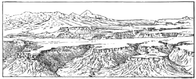
Fig. 129. Mesa Verde, Colorado
In the distance on the left are high volcanic mountains. On the extreme right are seen outliers of strata which once covered the region of the mesa
But in arid regions the mantle is rapidly removed, even from well- nigh level plains and plateaus, by the sweep of the wind and the wash of occasional rains. The geological structure of these regions of naked rock can be read as far as the eye can see, and it is to this structure that the forms of the land are there largely due. In a land mass of horizontal strata, for example, any softer surface rocks wear down to some underlying, resistant stratum, and this for a while forms the surface of a level plateau (Fig. 129). The edges of the capping layer, together with those of any softer layers beneath it, wear back in steep cliffs, dissected by the valleys of wet-weather streams and often swept bare to the base by the wind. As they are little protected by talus, which commonly is removed about as fast as formed, these escarpments and the walls of the valleys retreat indefinitely, exposing some hard stratum beneath which forms the floor of a widening terrace.
The high plateaus of northern Arizona and southern Utah (Fig. 130), north of the Grand Canyon of the Colorado River, are composed of stratified rocks more than ten thousand feet thick and of very gentle inclination northward. From the broad plat form in which the canyon has been cut rises a series of gigantic stairs, which are often more than one thousand feet high and a score or more of miles in breadth. The retreating escarpments, the cliffs of the mesas and buttes which they have left behind as outliers, and the walls of the ravines are carved into noble architectural forms— into cathedrals, pyramids, amphitheaters, towers, arches, and colonnades—by the processes of weathering aided by deflation. It is thus by the help of the action of the wind that great plateaus in arid regions are dissected and at last are smoothed away to waterless plains, either composed of naked rock, or strewed with residual gravels, or covered with drifting residual sand.

Fig. 130. North-South Section, Eighty-Five Miles Long, across the Plateau North of the Grand Canyon of the Colorado River, Arizona, showing Retreating Escarpments
O, outliers; V, canyon of the Colorado; A-H, rock systems from the Archean to the Tertiary; P, platform of the plateau from which the once overlying rocks have been stripped; dotted lines indicate probable former extension of the strata. How thick is the mass of strata which has been removed from over the platform? Has this work been accomplished while the Colorado River has been cutting its present canyon?
The specific gravity of air is 1⁄823 that of water. How does this fact affect the weight of the material which each can carry at the same velocity?
If the rainfall should lessen in your own state to from five to ten inches a year, what changes would take place in the vegetation of the country? in the soil? in the streams? in the erosion of valleys? in the agencies chiefly at work in denuding the land?
In what way can a wind-carved pebble be distinguished from a river-worn pebble? from a glaciated pebble?
CHAPTER VII
THE SEA AND ITS SHORES
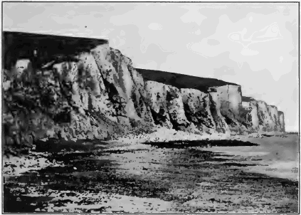
Fig. 131. Sea Cliff and Rock Bench Cut in Chalk, Dover, England
We have already seen that the ocean is the goal at which the waste of the land arrives. The mantle of rock waste, creeping down slopes, is washed to the sea by streams, together with the material which the streams have worn from their beds and that dissolved by underground waters. In arid regions the winds sweep waste either into bordering oceans or into more humid regions where rivers take it up and carry it on to the sea. Glaciers deliver the load of their moraines either directly to the sea or leave it for streams to transport to the same goal. All deposits made on the land, such as the flood plains of rivers, the silts of lake beds, dune sands, and sheets of glacial drift, mark but pauses in the process which is to bring all the materials of the land now above sea level to rest upon the ocean bed.
But the sea is also at work along all its shores as an agent of destruction, and we must first take up its work in erosion before we consider how it transports and deposits the waste of the land.
Sea Erosion
The sea cliff and the rock bench. On many coasts the land fronts the ocean in a line of cliffs (Fig. 131). To the edge of the cliffs there lead down valleys and ridges, carved by running water, which, if extended, would meet the water surface some way out from shore. Evidently they are now abruptly cut short at the present shore line because the land has been cut back.
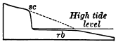
Fig. 132. Diagram of Sea Cliff sc, and Rock Bench rb The broken line indicates the former extent of the land.
Along the foot of the cliff lies a gently shelving bench of rock, more or less thickly veneered with sand and shingle. At low tide its inner margin is laid bare, but at high tide it is covered wholly, and the sea washes the base of the cliffs. A notch, of which the sea cliff and the rock bench are the two sides, has been cut along the shore (Fig. 132).
Waves. The position of the rock bench, with its inner margin slightly above low tide, shows that it has been cut by some agent which acts like a horizontal saw set at about sea level. This agent is clearly the surface agitation of the water; it is the wind-raised wave.
As a wave comes up the shelving bench the crest topples forward and the wave “breaks,” striking a blow whose force is measured by the momentum of all its tons of falling water (Fig. 133). On the coast of Scotland the force of the blows struck by the waves of the heaviest storms has sometimes exceeded three tons to the square foot. But even a calm sea constantly chafes the shore. It heaves in gentle undulations known as the ground swell, the result of storms perhaps a thousand miles distant, and breaks on the shore in surf.
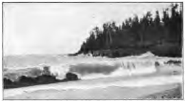
Fig. 133. Breaking Wave, Lake Superior
The blows of the waves are not struck with clear water only, else they would have little effect on cliffs of solid rock. Storm waves arm themselves with the sand and gravel, the cobbles, and even the large bowlders which lie at the base of the cliff, and beat against it with these hammers of stone.
Where a precipice descends sheer into deep water, waves swash up and down the face of the rocks but cannot break and strike effective blows. They therefore erode but little until the talus fallen from the cliff is gradually built up beneath the sea to the level at which the waves drag bottom upon it and break.
Compare the ways in which different agents abrade. The wind lightly brushes sand and dust over exposed surfaces of rock. Running water sweeps fragments of various sizes along its channels, holding them with a loose hand. Glacial ice grinds the stones of its ground moraine against the underlying rock with the pressure of its enormous weight. The wave hurls fragments of rock against the sea cliff, bruising and battering it by the blow. It also rasps the bench as it drags sand and gravel to and fro upon it.
Weathering of sea cliffs. The sea cliff furnishes the weapons for its own destruction. They are broken from it not only by the wave but also by the weather. Indeed the sea cliff weathers more rapidly, as a rule, than do rock ledges inland. It is abundantly wet with spray. Along its base the ground water of the neighboring land finds its natural outlet in springs which under mine it. Moreover, it is unprotected by any shield of talus. Fragments of rock as they fall from its face are battered to pieces by the waves and swept out to sea. The cliff is thus left exposed to the attack of the weather, and its retreat would be comparatively rapid for this reason alone.
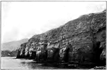
Fig. 134. Sea Caves, La Jolla, California Copyright, 1899, by the Detroit Photography Company
Sea cliffs seldom overhang, but commonly, as in Figure 134, slope seaward, showing that the upper portion has retreated at a more rapid rate than has the base. Which do you infer is on the whole the more destructive agent, weathering or the wave?
Draw a section of a sea cliff cut in well jointed rocks whose joints dip toward the land. Draw a diagram of a sea cliff where the joints dip toward the sea.
Sea caves. The wave does not merely batter the face of the cliff. Like a skillful quarryman it inserts wedges in all natural fissures, such as joints, and uses explosive forces. As a wave flaps against a crevice it compresses the air within with the sudden stroke; as it falls back the air as suddenly expands. On lighthouses heavily barred doors have been burst outward by the explosive force of the air within, as it was released from pressure when a partial vacuum was formed by the refluence of the wave. Where a crevice is filled with water the entire force of the blow of the wave is transmitted by hydraulic pressure to the sides of the fissure. Thus storm waves little by little pry and suck the rock loose, and in this way, and by the blows which they strike with the stones of the beach, they quarry out about a joint, or wherever the rock may be weak, a recess known as a sea cave, provided that the rock above is coherent enough to form a roof. Otherwise an open chasm results.
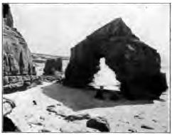
Fig. 135. A Sea Arch, California Copyright, 1899, by the Detroit Photography Company
Blowholes and sea arches. As a sea cave is drilled back into the rock, it may encounter a joint or crevice opened to the surface by percolating water. The shock of the waves soon enlarges this to a blowhole, which one may find on the breezy upland, perhaps a hundred yards and more back from the cliff’s edge. In quiet weather the blowhole is a deep well; in storm it plays a fountain as the waves drive through the long tunnel below and spout their spray high in air in successive jets. As the roof of the cave thus breaks down in the rear, there may remain in front for a while a sea arch, similar to the natural bridges of land caverns (Fig. 135).
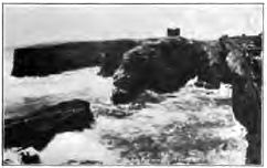
Fig. 136. Chasms worn by Waves, Coast of Scotland
Stacks and wave-cut islands. As the sea drives its tunnels and open drifts into the cliff, it breaks through behind the intervening portions and leaves them isolated as stacks, much as monuments are detached from inland escarpments by the weather; and as the sea cliff retreats, these remnant masses may be left behind as rocky islets. Thus the rock bench is often set with stacks, islets in all stages of destruction, and sunken reefs,—all wrecks of the land testifying to its retreat before the incessant attack of the waves.
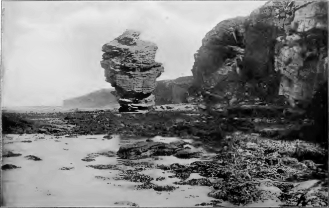
Fig. 137. A Stack, Scotland
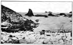
Fig. 138. Wave-Cut Islands, Scotland How far did the land once extend?
Coves. Where zones of soft or closely jointed rock outcrop along a shore, or where minor water courses conic down to the sea and aid in erosion, the shore is worn back in curved reëntrants called coves; while the more resistant rocks on either hand are left projecting as headlands (Fig. 139). After coves are cut back a short distance by the waves, the headlands come to protect them, as with breakwaters, and prevent their indefinite retreat. The shore takes a curve of equilibrium, along which the hard rock of the exposed headland and the weak rock of the protected cove wear back at an equal rate.
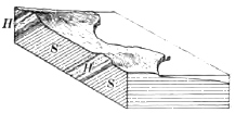
Fig. 139. Coves formed in Softer Strata S, S; while the Harder Strata H, H, are left as Headlands
Rate of recession. The rate at which a shore recedes depends on several factors. In soft or incoherent rocks exposed to violent storms the retreat is so rapid as to be easily measured. The coast of Yorkshire, England, whose cliffs are cut in glacial drift, loses seven feet a year on the average, and since the Norman conquest a strip a mile wide, with farmsteads and villages and historic seaports, has been devoured by the sea. The sandy south shore of Martha’s Vineyard wears back three feet a year. But hard rocks retreat so slowly that their recession has seldom been measured by the records of history.
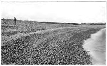
Fig. 140. A Pebble Beach, Cape Ann, Massachusetts
Shore Drift
Bowlder and pebble beaches. About as fast as formed the waste of the sea cliff is swept both along the shore and out to sea. The road of waste along shore is the beach. We may also define the beach as the exposed edge of the sheet of sediment formed by the carriage of land waste out to sea. At the foot of sea cliffs, where the waves are pounding hardest, one commonly finds the rock bench strewn on its inner margin with large stones, dislodged by the waves and by the weather and some-what worn on their corners and edges. From this bowlder beach the smaller fragments of waste from the cliff and the fragments into which the bowlders are at last broken drift on to more sheltered places and there accumulate in a pebble beach, made of pebbles well rounded by the wear which they have suffered. Such beaches form a mill whose raw material is constantly supplied by the cliff. The breakers of storms set it in motion to a depth of several feet, grinding the pebbles together with a clatter to be heard above the roar of the surf. In such a rock crusher the life of a pebble is short. Where ships have stranded on our Atlantic coast with cargoes of hard-burned brick or of coal, a year of time and a drift of five miles along the shore have proved enough to wear brick and coal to powder. At no great distance from their source, therefore, pebble beaches give place to beaches of sand, which occupy the more sheltered reaches of the shore.
Sand beaches. The angular sand grains of various minerals into which pebbles are broken by the waves are ground together under the beating surf and rounded, and those of the softer minerals are crushed to powder. The process, however, is a slow one, and if we study these sand grains under a lens we may be surprised to see that, though their corners and edges have been blunted, they are yet far from the spherical form of the pebbles from which they were derived. The grains are small, and in water they have lost about half their weight in air; the blows which they strike one another are therefore weak. Besides, each grain of sand of the wet beach is protected by a cushion of water from the blows of its neighbors.
The shape and size of these grains and the relative proportion of grains of the softer minerals which still remain give a rough measure of the distance in space and time which they have traveled from their source. The sand of many beaches, derived from the rocks of adjacent cliffs or brought in by torrential streams from neighboring highlands, is dark with grains of a number of minerals softer than quartz. The white sand of other beaches, as those of the east coast of Florida, is almost wholly composed of quartz grains; for in its long travel down the Atlantic coast the weaker minerals have been worn to powder and the hardest alone survive.
How does the absence of cleavage in quartz affect the durability of quartz sand?
How shore drift migrates. It is under the action of waves and currents that shore drift migrates slowly along a coast. Where waves strike a coast obliquely they drive the waste before them little by little along the shore. Thus on a north-south coast, where the predominant storms are from the northeast, there will be a migration of shore drift southwards.
All shores are swept also by currents produced by winds and tides. These are usually far too gentle to transport of themselves the coarse materials of which beaches are made. But while the wave stirs the grains of sand and gravel, and for a moment lifts them from the bottom, the current carries them a step forward on their way. The current cannot lift and the wave cannot carry, but together the two transport the waste along the shore. The road of shore drift is therefore the zone of the breaking waves.
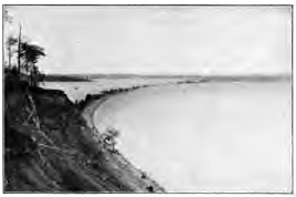
Fig. 141. A Bay Bar, Lake Ontario
The bay-head beach. As the waste derived from the wear of waves and that brought in by streams is trailed along a coast it assumes, under varying conditions, a number of distinct forms. When swept into the head of a sheltered bay it constitutes the bay-head beach. By the highest storm waves the beach is often built higher than the ground immediately behind it, and forms a dam inclosing a shallow pond or marsh.
The bay bar. As the stream of shore drift reaches the mouth of a bay of some size it often occurs that, instead of turning in, it sets directly across toward the opposite headland. The waste is carried out from shore into the deeper waters of the bay mouth; where it is no longer supported by the breaking waves, and sinks to the bottom. The dump is gradually built to the surface as a stubby spur, pointing across the bay, and as it reaches the zone of wave action current and wave can now combine to carry shore drift along it, depositing their load continually at the point of the spur. An embankment is thus constructed in much the same manner as a railway fill, which, while it is building, serves as a roadway along which the dirt from an adjacent cut is carted to be dumped at the end. When the embankment is completed it bridges the bay with a highway along which shore drift now moves without interruption, and becomes a bay bar.
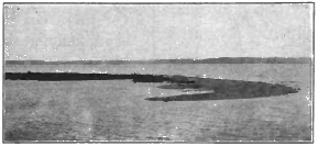
Fig. 142. A Hook, Lake Michigan
Incomplete bay bars. Under certain conditions the sea cannot carry out its intention to bridge a bay. Rivers discharging in bays demand open way to the ocean. Strong tidal currents also are able to keep open channels scoured by their ebb and flow. In such cases the most that land waste can do is to build spits and shoals, narrowing and shoaling the channel as much as possible. Incomplete bay bars sometimes have their points recurved by currents setting at right angles to the stream of shore drift and are then classified as hooks (Fig. 142).

Fig. 143. Cross Section of Sand Reef sr, and Lagoon; sl, Sea Level
Sand reefs. On low coasts where shallow water extends some distance out, the highway of shore drift lies along a low, narrow ridge, termed the sand reef, separated from the land by a narrow stretch of shallow water called the lagoon (Fig. 143). At intervals the reef is held open by inlets,—gaps through which the tide flows and ebbs, and by which the water of streams finds way to the sea.
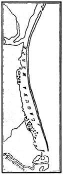
Fig. 144. Sand Reef and Lagoon, Texas
No finer example of this kind of shore line is to be found in the world than the coast of Texas. From near the mouth of the Rio Grande a continuous sand reef draws its even curve for a hundred miles to Corpus Christi Pass, and the reefs are but seldom interrupted by inlets as far north as Galveston Harbor. On this coast the tides are variable and exceptionally weak, being less than one foot in height, while the amount of waste swept along the shore is large. The lagoon is extremely shallow, and much of it is a mud flat too shoal for even small boats. On the coast of New Jersey strong tides are able to keep open inlets at intervals of from two to twenty miles in spite of a heavy alongshore drift.
Sand reefs are formed where the water is so shallow near shore that storm waves cannot run in it and therefore break some distance out from land. Where storm waves first drag bottom they erode and deepen the sea floor, and sweep in sediment as far as the line where they break. Here, where they lose their force, they drop their load and beat up the ridge which is known as the sand reef when it reaches the surface.
Shores of Elevation and Depression
Our studies have already brought to our notice two distinct forms of strand lines,—one the high, rocky coast cut back to cliffs by the attack of the waves, and the other the low, sandy coast where the waves break usually upon the sand reef. To understand the origin of these two types we must know that the meeting place of sea and land is determined primarily by movements of the earth’s crust. Where a coast land emerges the—shore line moves seaward; where it is being submerged the shore line advances on the land.
Shores of elevation. The retreat of the sea, either because of a local uplift of the land or for any other reason, such as the lowering of any portion of ocean bottom, lays bare the inner margin of the sea floor. Where the sea floor has long received the waste of the land it has been built up to a smooth, subaqueous plain, gently shelving from the land. Since the new shore line is drawn across this even surface it is simple and regular, and is bordered on the one side by shallow water gradually deepening seaward, and on the other by low land composed of material which has not yet thoroughly consolidated to firm rock. A sand reef is soon beaten up by the waves, and for some time conditions will favor its growth. The loss of sand driven into the lagoon beyond, and of that ground to powder by the surf and carried out to sea, is more than made up by the stream of alongshore drift, and especially by the drag of sediments to the reef by the waves as they deepen the sea floor on its seaward side.
Meanwhile the lagoon gradually fills with waste from the reef and from the land. It is invaded by various grasses and reeds which have learned to grow in salt and brackish water; the marsh, laid bare only at low tide, is built above high tide by wind drift and vegetable deposits, and becomes a meadow, soldering the sand reef to the mainland.
While the lagoon has been filling, the waves have been so deepening the sea floor off the sand reef that at last they are able to attack it vigorously. They now wear it back, and, driving the shore line across the lagoon or meadow, cut a line of low cliffs on the mainland. Such a shore is that of Gascony in southwestern France,—a low, straight, sandy shore, bordered by dunes and unprotected by reefs from the attack of the waves of the Bay of Biscay.
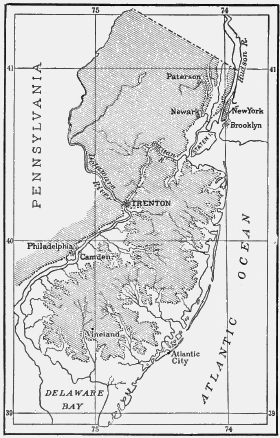
Fig. 145. Map of New Jersey, with that Portion of the State one Hundred Feet and more above Sea Level shaded Describe the coast line which the state would have if depressed one hundred feet. Compare it with the present coastline
We may say, then, that on shores of elevation the presence of sand reefs and lagoons indicates the stage of youth, while the absence of these features and the vigorous and unimpeded attack by the sea upon the mainland indicate the stage of maturity. Where much waste is brought in by rivers the maturity of such a coast may be long delayed. The waste from the land keeps the sea shallow offshore and constantly renews the sand reef. The energy of the waves is consumed in handling shore drift, and no energy is left for an effective attack upon the land. Indeed, with an excessive amount of waste brought down by streams the land may be built out and encroach temporarily upon the sea; and not until long denudation has lowered the land, and thus decreased the amount of waste from it, may the waves be able to cut through the sand reef and thus the coast reach maturity.
Shores of Depression
Where a coastal region is undergoing submergence the shore line moves landward. The horizontal plane of the sea now intersects an old land surface roughened by subaërial denudation. The shore line is irregular and indented in proportion to the relief of the land and the amount of the submergence which the land has suffered. It follows up partially submerged valleys, forming bays, and bends round the divides, leaving them to project as promontories and peninsulas. The outlines of shores of depression are as varied as are the forms of the land partially submerged. We give a few typical illustrations.
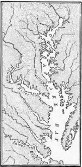
Fig. 146. Chesapeake Bay Draw a sketch of this area before its depression
The characteristics of the coast of Maine are due chiefly to the fact that a mountainous region of hard rocks, once worn to a peneplain, and after a subsequent elevation deeply dissected by north-south valleys, has subsided, the depression amounting on its southern margin to as much as six hundred feet below sea level. Drowned valleys penetrate the land in long, narrow bays, and rugged divides project in long, narrow land arms prolonged seaward by islands representing the high portions of their extremities. Of this exceedingly ragged shore there are said to be two thousand miles from the New Brunswick boundary as far west as Portland,—a straight-line distance of but two hundred miles. Since the time of its greatest depression the land is known to have risen some three hundred feet; for the bays have been shortened, and the waste with which their floors were strewn is now in part laid bare as clay plains about the bay heads and in narrow selvages about the peninsulas and islands.
The coast of Dalmatia, on the Adriatic Sea, is characterized by long land arms and chains of long and narrow islands, all parallel to the trend of the coast. A region of parallel mountain ranges has been depressed, and the longitudinal valleys which lie between them are occupied by arms of the sea.
Chesapeake Bay is a branching bay due to the depression of an ancient coastal plain which, after having emerged from the sea, was channeled with broad, shallow valleys. The sea has invaded the valley of the trunk stream and those of its tributaries, forming a shallow bay whose many branches are all directed toward its axis (Fig. 146).
Hudson Bay, and the North, the Baltic, and the Yellow seas are examples where the sinking of the land has brought the sea in over low plains of large extent, thus deeply indenting the continental out-line. The rise of a few hundred feet would restore these submerged plains to the land.
The cycle of shores of depression. In its infantile stage the outline of a shore of depression depends almost wholly on the previous relief of the land, and but little on erosion by the sea. Sea cliffs and narrow benches appear where headlands and outlying islands have been nipped by the waves. As yet, little shore waste has been formed. The coast of Maine is an example of this stage.
In early youth all promontories have been strongly cliffed, and under a vigorous attack of the sea the shore of open bays may be cut back also. Sea stacks and rocky islets, caves and coves, make the shore minutely ragged. The irregularity of the coast, due to depression, is for a while increased by differential wave wear on harder and softer rocks. The rock bench is still narrow. Shore waste, though being produced in large amounts, is for the most part swept into deeper water and buried out of sight. Examples of this stage are the east coast of Scotland and the California coast near San Francisco.
Later youth is characterized by a large accumulation of shore waste. The rock bench has been cut back so that it now furnishes a good roadway for shore drift. The stream of alongshore drift grows larger and larger, filling the heads of the smaller bays with beaches, building spits and hooks, and tying islands with sand bars to the mainland. It bridges the larger bays with bay bars, while their length is being reduced as their inclosing promontories are cut back by the waves. Thus there comes to be a straight, continuous, and easy road, no longer interrupted by headlands and bays, for the transportation of waste alongshore. The Baltic coast of Germany is in this stage.
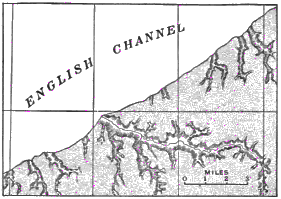
Fig. 147. Portion of the Northwest Coast of France
All this while streams have been busy filling with delta deposits the bays into which they empty. By these steps a coast gradually advances to maturity, the stage when the irregularities due to depression have been effaced, when outlying islands formed by subsidence have been planed away, and when the shore line has been driven back behind the former bay heads. The sea now attacks the land most effectively along a continuous and fairly straight line of cliffs. Although the first effect of wave wear was to increase the irregularities of the shore, it sooner or later rectifies it, making it simple and smooth. The northwest coast of France is often cited as an example of a coast which has reached this stage of development (Fig. 147).
In the old age of coasts the rock bench is cut back so far that the waves can no longer exert their full effect upon the shore. Their energy is dissipated in moving shore drift hither and thither and in abrading the bench when they drag bottom upon it. Little by little the bench is deepened by tidal currents and the drag of waves; but this process is so slow that meanwhile the sea cliffs melt down under the weather, and the bench becomes a broad shoal where waves and tides gradually work over the waste from the land to greater fineness and sweep it out to sea.
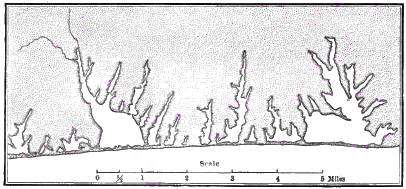
Fig. 148. The South Shore of Martha’s Vineyard
The land is shaded. To what class of coasts does this belong? What stage has it reached, and by what process? What changes will take place in the future?
Plains of marine abrasion. While subaërial denudation reduces the land to baselevel, the sea is sawing its edges to wave base, i.e. the lowest limit of the wave’s effective wear. The widened rock bench forms when uplifted a plain of marine abrasion, which like the peneplain bevels across strata regardless of their various inclinations and various degrees of hardness.
How may a plain of marine abrasion be expected to differ from a peneplain in its mantle of waste?
Compared with subaërial denudation, marine abrasion is a comparatively feeble agent. At the rate of five feet per century—a higher rate than obtains on the youthful rocky, coast of Britain—it would require more than ten million years to pare a strip one hundred miles wide from the margin of a continent, a time sufficient, at the rate at which the Mississippi valley is now being worn away, for subaërial denudation to lower the lands of the globe to the level of the sea.
Slow submergence favors the cutting of a wide rock bench. The water continually deepens upon the bench; storm waves can therefore always ride in to the base of the cliffs and attack them with full force; shore waste cannot impede the onset of the waves, for it is continually washed out in deeper water below wave base.
Basal conglomerates. As the sea marches across the land during a slow submergence, the platform is covered with sheets of sea-laid sediments. Lowest of these is a conglomerate,—the bowlder and pebble beach, widened indefinitely by the retreat of the cliffs at whose base it was formed, and preserved by the finer deposits laid upon it in the constantly deepening water as the land subsides. Such basal conglomerates are not uncommon among the ancient rocks of the land, and we may know them by their rounded pebbles and larger stones, composed of the same kind of rock as that of the abraded and evened surface on which they lie.
CHAPTER VIII
OFFSHORE AND DEEP-SEA DEPOSITS
The alongshore deposits which we have now studied are the exposed edge of a vast subaqueous sheet of waste which borders the continents and extends often for as much as two or three hundred miles from land. Soundings show that offshore deposits are laid in belts parallel to the coast, the coarsest materials lying nearest to the land and the finest farthest out. The pebbles and gravel and the clean, coarse sand of beaches give place to broad stretches of sand, which grows finer and finer until it is succeeded by sheets of mud. Clearly there is an offshore movement of waste by which it is sorted, the coarser being sooner dropped and the finer being carried farther out.
Offshore Deposits
The débris torn by waves from rocky shores is far less in amount than the waste of the land brought down to the sea by rivers, being only one thirty-third as great, according to a conservative estimate. Both mingle alongshore in all the forms of beach and bar that have been described, and both are together slowly carried out to sea. On the shelving ocean floor waste is agitated by various movements of the unquiet water,—by the undertow (an outward‑running bottom current near the shore), by the ebb and flow of tides, by ocean currents where they approach the land, and by waves and ground swells, whose effects are sometimes felt to a depth of six hundred feet. By all these means the waste is slowly washed to and fro, and as it is thus ground finer and finer and its soluble parts are more and more dissolved, it drifts farther and farther out from land. It is by no steady and rapid movement that waste is swept from the shore to its final resting place. Day after day and century after century the grains of sand and particles of mud are shifted to and fro, winnowed and spread in layers, which are destroyed and rebuilt again and again before they are buried safe from further disturbance.
These processes which are hidden from the eye are among the most important of those with which our science has to do; for it is they which have given shape to by far the largest part of the stratified rocks of which the land is made.
The continental delta. This fitting term has been recently suggested for the sheet of waste slowly accumulating along the borders of the continents. Within a narrow belt, which rarely exceeds two or three hundred miles, except near the mouths of muddy rivers such as the Amazon and Congo, nearly all the waste of the continent, whether worn from its surface by the weather, by streams, by glaciers, or by the wind, or from its edge by the chafing of the waves, comes at last to its final resting place. The agencies which spread the material of the continental delta grow more and more feeble as they pass into deeper and more quiet water away from shore. Coarse materials are therefore soon dropped along narrow belts near land. Gravels and coarse sands lie in thick, wedge-shaped masses which thin out seaward rapidly and give place to sheets of finer sand.
Sea muds. Outermost of the sediments derived from the waste of the continents is a wide belt of mud; for fine clays settle so slowly, even in sea water,—whose saltness causes them to sink much faster than they would in fresh water,—that they are wafted far before they reach a bottom where they may remain undisturbed. Muds are also found near shore, carpeting the floors of estuaries, and among stretches of sandy deposits in hollows where the more quiet water has permitted the finer silt to rest.
Sea muds are commonly bluish and consolidate to bluish shales; the red coloring matter brought from land waste—iron oxide—is altered to other iron compounds by decomposing organic matter in the presence of sea water. Yellow and red muds occur where the amount of iron oxide in the silt brought down to the sea by rivers is too great to be reduced, or decomposed, by the organic matter present.
Green muds and green sand owe their color to certain chemical changes which take place where waste from the land accumulates on the sea floor with extreme slowness. A greenish mineral called glauconite—a silicate of iron and alumina—is then formed. Such deposits, known as green sand, are now in process of making in several patches off the Atlantic coast, and are found on the coastal plain of New Jersey among the offshore deposits of earlier geological ages.
Organic deposits. Living creatures swarm along the shore and on the shallows out from land as nowhere else in the ocean. Seaweed often mantles the rock of the sea cliff between the levels of high and low tide, protecting it to some degree from the blows of waves. On the rock bench each little pool left by the ebbing tide is an aquarium abounding in the lowly forms of marine life. Below low-tide level occur beds of molluscous shells, such as the oyster, with countless numbers of other humble organisms. Their harder parts—the shells of mollusks, the white framework of corals, the carapaces of crabs and other crustaceans, the shells of sea urchins, the bones and teeth of fishes—are gradually buried within the accumulating sheets of sediment, either whole or, far more often, broken into fragments by the waves.
By means of these organic remains each layer of beach deposits and those of the continental delta may contain a record of the life of the time when it was laid. Such a record has been made ever since living creatures with hard parts appeared upon the globe. We shall find it sealed away in the stratified rocks of the continents,— parts of ancient sea deposits now raised to form the dry land. Thus we have in the traces of living creatures found in the rocks, i.e. in fossils, a history of the progress of life upon the planet.
Fig. 149. Coquina, Florida
Molluscous shell deposits. The forms of marine life of importance in rock making thrive best in clear water, where little sediment is being laid, and where at the same time the depth is not so great as to deprive them of needed light, heat, and of sufficient oxygen absorbed by sea water from the air. In such clear and comparatively shallow water there often grow countless myriads of animals, such as mollusks and corals, whose shells and skeletons of carbonate of lime gradually accumulate in beds of limestone.
A shell limestone made of broken fragments cemented together is sometimes called coquina, a local term applied to such beds recently uplifted from the sea along the coast of Florida (Fig. 149).
Oölitic limestone (ōon, an egg; lithos, a stone) is so named from the likeness of the tiny spherules which compose it to the roe of fish. Corals and shells have been pounded by the waves to calcareous sand, and each grain has been covered with successive concentric coatings of lime carbonate deposited about it from solution.