PHILOSOPHICAL JOURNAL. (continued 4)
Reading edition
"Near Abusimbel, on the west bank, I found the ground of the temple 6·50 metres (21 feet 2 inches) above the highest water-level. This temple, it is well known, was built under Rameses the Great, between 1388 and 1322 years before Christ. Near Ibrim there are, on the east bank, four grottoes excavated in the vertical rock that bounds the river, which belong partly to the 18th and partly to the 19th dynasties; the last, under Rameses the Great, is also the lowest, and only 2·50 metres (8 feet 1 inch) above the highest inundation; the next in height is 2·70 metres (8 feet 9½ inches) above the former, and was made 250 years earlier, under Tutmes III. Although I only measured the present level of the valley near Korusko, nevertheless it appears to me that, during the whole of the new kingdom, that is, from about 1700 years before Christ to this time, the Nile has not reached to the full height of the low land of the valley.
It is, however, conceivable that, at the time when the present low land of the Nubian Valley was formed, the cataracts at Assuan were in a totally different state; one that would, in some degree, justify the overcharged descriptions of the ancients, according to whom they made so great a noise that the dwellers near them became deaf. The damming up of the inundation at Assuan could have no material influence on Egypt, any more than that at Semne, or the land from thence to Assuan.
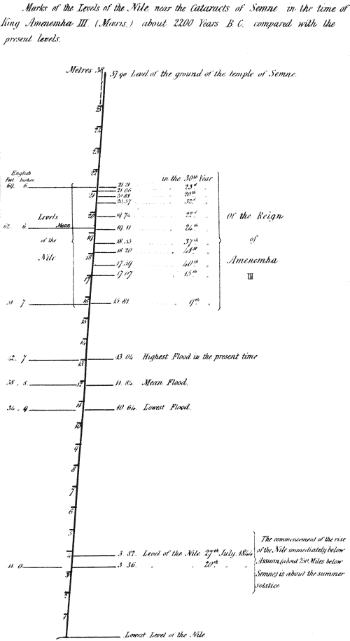
It appears therefore, from the above statements, that at the time mentioned, the Nile, during the inundations, stood 26 feet 8 inches higher than the highest level to which it now rises in years of the greatest floods; and that, to account for this, Professor Lepsius conceives that, between the time of Mœsis and the present day, the bed of the Nile, from a considerable distance above Semne to Assuan, must have been worn down to that extent. In the index to the volume of the Berlin Monatsbericht, in which the letters of Professor Lepsius are inserted, there is the following line:—
Nil, senkung seines Bettes um 25 Fuss seit 4000 Jahren.
Nile, sinking of its bed about 25 feet (Paris) within the last 4000 years.
Rivers are, undoubtedly, among the most active agents of change that are operating on the earth's surface; the solid matter which renders their waters turbid, and which they unceasingly carry to the sea, afford indisputable proof of this agency. But the power of rivers to abrade and wear down the rocks over which they flow, and to form and deepen their own bed, depends upon a variety of circumstances not always taken into account; and although the great extent of that power, in both respects, is shewn in the case of many rivers, to conclude, as some have done, from these instances, that all rivers have excavated the channels in which they flow, is a generalization that cannot be safely assented to. The excavation of the bed of a river is one of those problems in geological dynamics which can only be rightly solved by each particular case being subjected to the rigorous examination of the mathematician and the physicist. The solid matter which rivers carry forward is in part only the produce of their own abrading power; and the amount of it must be proportional to that power, which is mainly dependent on their velocity; they are the recipients of the waste of the adjoining lands by other combined agencies, and the carriers of it to the lower districts and to the sea. They often afford the strongest evidence of the vast lapse of time that must be included between the beginning and close of a geological period; and, when they flow through countries whose remote political history is known to us, they supply a scale by which we may measure and estimate that lapse of time. This is especially so in the case of the Nile.
When so startling an hypothesis as that now referred to, viz., that the entire bed of so vast a river as the Nile, for more than 250 miles, from Semne to Assuan, has been excavated, within historical time, to a depth of 27 feet, is made by a person whose name carries so much weight in one department of philosophical inquiry, the statement involves such important geological considerations, that it becomes the duty of the geologist to examine, and thoroughly test the soundness of the explanation, in order that the authority of Professor Lepsius, for the accuracy of the facts observed, may not be too readily admitted as conclusive for the correctness of his theory of the cause to which they owe their existence. That there has been such an undoubting admission, appears from the following passage in the work of one of the latest writers on Nubia:—
The translation of the name of this town (Aswán) is 'the opening;' and a great opening this once was, before the Nile had changed its character in Ethiopia, and when the more ancient races made this rock (at the first cataract) their watch-tower on the frontier between Egypt and the south. That the Nile has changed its character, south of the first cataract, has been made clear by some recent examinations of the shores and monuments of Nubia. Dr Lepsius has discovered water-marks so high on the rocks and edifices, and so placed as to compel the conviction that the bed of the Nile has sunk extraordinarily by some great natural process, either of convulsion or wear. The apparent exaggerations of some old writers about the cataracts at Syene may thus be in some measure accounted for. If there really was once a cataract here, instead of the rapids of the present day, there is some excuse for the reports given from hearsay by Cicero and Seneca. Cicero says, that 'the river throws itself headlong from the loftiest mountains, so that those who live nearest are deprived of the sense of hearing, from the greatness of the noise.' Seneca's account is: 'When some people were stationed there by the Persians, their ears were so stunned with the constant roar, that it was found necessary to remove them to a more quiet place.'[54]
Note.—The learned author of an article on Egyptian Chronology and History in the Prospective Review for May 1850, in referring to the contributions of Professor Lepsius to Egyptian history, says, He has discovered undescribed pyramids, equal in number to those known before; has traced the Labyrinth, and ascertained its founder. He has detected inscriptions on the banks of the Nile, which show that its bed has subsided many feet in historic times. 9th June 1850.
In the assumption of an excavation of the bed of the river, we have no small amount of wear to deal with, for the distance from Semne to Assuan, following the course of the river, is not less than 250 miles; and if, as Professor Lepsius supposes, the excavation extended to Meroë, we have a distance, between that place and Assuan, of not less than 600 miles.
Although these records of a former high level of the Nile at Semne had not been noticed by any traveller prior to Professor Lepsius, we may rest fully assured of the accuracy of his statements, from the habitual care and diligence, and the established character for fidelity, of the observer. The silence of other travellers may be readily accounted for by this, that none of them appear to have remained more than a very short time at this spot—not even the diligent Russegger—whereas we have seen that Professor Lepsius passed twelve days in the examination of this gorge in the Nile Valley.
The theory of a lowering of the bed of the river by wearing, involves two main considerations, viz., the power of the stream, and the degree of hardness of the rocks acted upon. The power depends upon the volume and velocity of the river—the velocity on its depth, and the degree of inclination of the bed: the hardness of the rocks we can form a tolerable estimate of when we know their nature. To judge, therefore, of the probability of the hypothesis of Professor Lepsius, we must inquire into the physical and geological features of the Nile Valley, in Nubia.
In the observations I have now to offer, my information has been derived of course entirely from the works of other travellers, particularly those of Burckhardt, Rüppell, and Russegger,[55] and especially the latter, who travelled in Nubia in 1837; for he not only enters far more into the details of the natural history of the country, but he is the only traveller in Nubia who appears, from previous acquirements, to have been competent to describe its natural history with any degree of accuracy—I refer more particularly to the physical and geological features of the country. Besides full descriptions in his volumes, he has given a geological map of Nubia, and also several sections, or what may more properly be called vertical sketches—a term that would, perhaps, be a more appropriate designation for all sections that are not drawn to a true scale, or at least when the proportion of height to horizontal distance is not stated.
The Physical Geography of Lower Nubia.[56]
Russegger informs us,[57] that he believes he was the first traveller who had succeeded in making a series of barometrical measurements along the Nile Valley, from the Mediterranean to Sennaar and Kordofan, and thence to the 10th degree of north latitude. He gives the following altitudes, above the sea:—
Paris Feet.English Feet.
The upper part of the Cataract of Assuan,342=364·37
Korusko, on the right bank of the Nile, in Nubia,450=479·43
Wadi-Halfa,490=522·00
New Dongola,757=806·52
Abu Hammed,963=1026·00
I shall now give the length of the Nile along its course from Abu Hammed to the island of Philæ, at the head of the cataract of Assuan. I employ for this purpose the map in the atlas which accompanies the work of Russegger, which bears the date of 1846, and which, doubtless, was constructed on the best authorities. He mentions a map of General von Prokesch with great praise.[58] It flows:—
German M.English M.
From NE. to SW., from Abu Hammed to Meroë, about31=150
It makes a curve between Meroë and Old Dongola, of about16=77
It flows between Old and New Dongola, from SE. to NW., about16=77
Then, with some short windings, nearly due north to the island of Sais, for about30=145
And from Sais to the island of Philæ, from SW. to NE., about68=327
Making the whole length of the course, from Abu Hammed to Philæ, about161=776
Ascending the river, we have, between Philæ and Korusko, a distance of 24 German, or 115½ English miles, and without any rapid, except one near Kalabsche. Korusko being 115 feet above the head of the cataract of Assuan, at Philæ, we have an average fall of the river between these two places of a foot in a mile.
Between Korusko and Wadi-Halfa there is no rapid. The distance being 20 German, or 96⅓ English miles, and the difference of altitude being 42½ feet, we have an average fall throughout that part of the river's course of not more than 5·3 inches in a mile.
This very inconsiderable fall need not surprise us; for the average fall of the Nile in Lower Egypt, at the lowest water, is little more than one-third of that now stated. At the time of the highest water the surface of the Nile, at Boulak, near Cairo; that is, about 116 miles in a direct line from the coast is only 43·437 English feet above the level of the Mediterranean, and at the time of the lowest water, only 17·33 feet. Thus, in the first case, there is an average fall of about 5·00 inches; in the second, of not more than 1·80 inches in a mile.[59]
Between Wadi Halfa and Dale, a distance of about 94 miles, six cataracts, or schellals, as they are called in the language of the country, are marked in Russegger's map. And here, it may be as well to notice, that there are no cataracts, in the ordinary sense of the term, on the Nile; no fall of the river over a precipice; all the so-called cataracts are rapids, where the river rushes through rocks in its bed; the rapids varying in their length and degrees of inclination. We have no measurements of their lengths or of their falls, except as regards the first and second cataracts. The former, according to Russegger, has a fall of about 85 English feet in a distance of about 8 miles; and he describes the latter as extending from 5 to 6 stunden; that is, from 12 to 14½ miles, but he does not give the height. Speaking of the schellals above Semne, Russegger says, that all may be passed in boats without difficulty for about six weeks, or two months in the year. This is the case also, at the cataract or rapid of Assuan. But between Wadi-Halfa and Dale, with some inconsiderable spaces of free navigable water, in the ordinary state of the river, there is an almost uninterrupted series of rapids. We have no measurement of the height of Dale above Wadi-Halfa, near to which the second great cataract of the Nile occurs; but this is the part of the river's course where the fall is greatest, and from Semne to Dale there are about 45 miles of this more rapid fall.
From Dale to New Dongola, a distance of 35 German, or about 168 English miles, only three rapids are marked on Russegger's map—the highest being at Hannek, about 26 English miles below New Dongola. New Dongola being 806 English feet above the sea, and the distance from that place to the rapid of Hannek being 26 miles only, we may with probability estimate the surface of the river at the rapid of Hannek at 780 feet above the sea. Now, Wadi-Halfa being 522 feet, we have a difference of height, between these two last-named places, of 258 feet; and the length of the river's course between them being 236 miles, we have an average fall of 13·12 inches in a mile; that is, in the part of the river's course where nine rapids occur, in the provinces of Batn-el-Hadjar, Sukkot, and Dar-el-Mahass, where the river flows over granite and other plutonic rocks; gneiss, mica-schist, and other hard rocks, which Russegger considers to be metamorphic. But between Semne and the head of the second cataract at Wadi-Halfa, there is not a continuous rapid stream; for Hoskins says, that about two miles above that cataract, the river has a width of a third of a mile, and, when he passed it the water was scarcely ruffled.[60]
From the rapid of Hannek to Abu Hammed, the distance is 329 English miles, and the difference of altitude is 246 English feet. We have thus an average fall in that distance of 9·00 inches in a mile.
Thus, in the 776 miles between Abu Hammed and Philæ, we have an average fall of the Nile
Of 9·00inches in a mile,for a distance of329miles.
Of 13·12..................236...
Of 5·30..................96...
Of 12·00..................115...
Of the Breadth, Depth, and Velocity of the Nile, in Nubia.
Our information is very scanty respecting the breadth and depth of the river, either at the time of lowest water or during the inundations. About two miles above Philæ, it is stated by Jomard[61] to be 3000 metres, or nearly two English miles wide. At the second cataract, or rapid of Wadi-Halfa, it spreads over a rocky bed of nearly two miles and a-quarter in width (2000 klafter),[62] but contracts above the rapid to a third of a mile. Russegger also states, that the Nile, near Boulak, in Lower Egypt, is 2000 toises, nearly two-and-a-half English miles in breadth, and yet that it is considerably wider in some parts of Southern Nubia; but Burckhardt says, that the bed of the Nile in Nubia is, in general, much narrower than in any part of Egypt. Near Kalabsche, about 30 miles above Philæ, the river runs through a gorge not more than 300 paces wide, and its bed is full of granite blocks. It shortly afterwards again widens for some distance; but near Sialla, 78 miles above Philæ, it is contracted by the sandstone hills on both sides coming so near each other, that the river's bed is again not more than from 250 to 300 paces wide. It is about 600 yards broad about two miles above the second cataract near Wadi-Halfa, but is again very much contracted in the rocky region of Batn-el-Hadjar. At Aulike it is only 200 paces broad.[63]
I have not met with any measurements of the depth of the river in any part of its course in Nubia; but Hoskins describes it as being so shallow at the island of Sais, 327 miles above Philæ, on the 9th of June, which would be before the commencement of the inundation, as only to reach the knees of the camels.[64] Near Derr, about 86 miles below the Cataract of Wadi-Halfa, Norden, in January, found the river so shallow that loaded camels waded through it, and his boat frequently struck the ground. In May, Burckhardt found the river fordable at Kostamne, 53 miles above Philæ; and Parthey states, that between Philæ and the island of Bageh, to the west of it, the river is so shallow before the commencement of the inundation, that it may be waded through.[65] Burckhardt says, that from March to June the Nile-water, in Nubia, is quite limpid.[66] Miss Martineau, who visited Nubia in December and January, speaking of the river above Philæ says, that it was divided into streamlets and ponds by the black islets. Where it was overshadowed it was dark-gray or deep blue, but when the light caught it rushing between a wooded island and the shore, it was of the clearest green.[67] At the second cataract she describes the river as dashing and driving among its thousand islets, and then gathering its thousand currents into one, proceeds calmly in its course.[68]
Although we have no accurate measurements of the velocity of the Nile in Nubia, we may arrive at an approximate estimate of it by comparing its fall with that of a river well known to us.
I have stated the fall of the Nile in different parts of its course to be 5·30, 9·00, 12·00, and 13·12 inches in a mile. The fall of the Thames from Wallingford to Teddington Lock, where the influence of the tide ends, is as follows:—
Length of course.Fall.Fall in inches per mile.
Miles. F.Feet. in.
From Wallingford to Reading Bridge,18·024·115·72
From Reading to Henley Bridge,9·019·325·68
From Henley to Marlow Bridge,9·012·216·20
From Marlow to Maidenhead Bridge,8·015·122·32
From Maidenhead to Windsor Bridge,7·013·623·16
From Windsor to Staines Bridge,8·015·823·52
From Staines to Chertsey Bridge,4·66·617·28
From Chertsey to Teddington Lock,13·619·817·40
77·4125·11
In general, the velocity may be estimated at from half-a-mile to two miles and three-quarters per hour; but the mean velocity may be reckoned at two miles per hour. In the year 1794, the late Mr Rennie found the velocity of the Thames at Windsor two miles and a half per hour.[69]
It will thus be seen that the velocity of the Nile is probably greatly inferior to that of the Thames; for it appears that, except during the inundation, for more than half the year the depth is inconsiderable. The average fall when greatest, that is, including the province of Batn-el-Hadjar, where the rapids chiefly occur, is considerably less than that of any part of the above course of the Thames; so that there must be long intervals between the rapids where the fall must be far less than 13 inches in a mile. The breadth of the Nile is vastly greater; but supposing the depth of the water to be the same as that of the Thames, on account of the friction of the bed, the greater breadth would add very little to the velocity. If we assume the average depth of the Thames in the above distance to be 5 feet, and that it flows with an average velocity of 2 miles in an hour, and if we assume the average depth of the Nile in that part of its course where the fall is 13·12 inches to be 10 feet, when not swollen by the rise, the velocity would be 2⅘ miles nearly in an hour,[70] if the fall were equal to that of the Thames. We shall probably come near the truth, by assuming the velocity of the Nile on this part at 2 miles in an hour. That it must be considerably less in the other divisions of the course I have named, and especially in that part immediately below the second cataract, where the average fall is only 5·30 inches for a distance of 96 miles, is quite evident.
The power of a river to abrade the soil over which it flows, so far as water is by itself capable of doing so, must depend upon its volume and velocity, and the degree of hardness of the material acted upon. The power is increased when the water has force enough to transport hard substances. But even transported gravel has little action on the rocks with which it comes in contact, when it is free to move in running water, unless the fall be considerable, and, consequently, the velocity and force of the stream great. When stones are firmly set in moving ice, they then acquire a great erosive power, cutting and wearing down the rocks they are forcibly rubbed against; but this condition never obtains in Lower Nubia, as ice is unknown there.
Geological Structure of Lower Nubia.
One kind only of regularly stratified rock occurs in the 776 miles from Abu Hammed to Philæ; viz. a silicious sandstone, similar to that which occurs to a great extent on both sides of the Nile in Upper Egypt, and which Russegger, after a very careful examination of it there, considers to be an equivalent of the greensand of the cretaceous rocks of Europe. The tertiary nummulite limestone, so abundant in Egypt, has not hitherto been met with in Nubia.
The Nile flows over this sandstone for nearly 426 miles of the entire distance, but not continuously. At Abu Hammed, it flows over granitic rocks, and these continue from that place for about 120 miles. There is then about 215 miles of the sandstone, which is succeeded by igneous and metamorphic rocks, that continue for 195 miles without any interruption, except a narrow stripe of sandstone of about 15 miles near Amara. It is in this region of hard igneous rocks that nearly all the rapids occur, between that of Hannek and the great or second cataract at Wadi-Halfa. From the latter place there is sandstone throughout a distance of about 196 miles, and then commences the granitic region of the Cataract of Assuan, through which the Nile flows about 35 miles. Thus we have about 350 miles of igneous and metamorphic[N8] rocks, and about 426 of sandstone.
The general hard nature of the igneous and metamorphic rocks, over which the Nile flows for about 155 miles above Semne, and for about 40 immediately below it, will be recognised by my naming some of the varieties described by Russegger, viz. granites of various kinds, often penetrated by greenstone dykes; sienite, diorite, and felspar porphyries; gneiss, and clay slate, penetrated by numerous quartz veins.
The siliceous sandstone is very uniform in its character; and in Nubia, as in Egypt, the only organic bodies which it has as yet been found to contain, are silicified stems of wood. Occasionally, as in the neighbourhood of Korusko, interstratified beds of marly clay are met with.[71]
When, therefore, we take into account the hard nature of the siliceous sandstone, the durability of which is shewn by the very ancient monuments of Egypt and Nubia, that are formed of it, and the still greater hardness of the granites and other crystalline rocks, it is manifest that the wearing action of a river flowing over so gentle a fall, can scarcely be appreciable. If the occasional beds of marly clay occur in the bank of the river, they may be washed out, and blocks of the superincumbent sandstones may fall down; but such an operation would have a tendency to raise rather than deepen the bed of the river at those places; unless the transporting power of the stream were far greater than can exist with so moderate a fall, especially in that part of the river below Semne, where, for 96 miles, it is not more than 5·3 inches, and for 115 miles below that, not more than 12 inches in a mile. Even if we suppose the river to have power to tear up its bed for some distance above Semne and below it, as far as the rapid of Wadi-Halfa, it is evident that the materials brought down would be deposited, except the finest particles, in that tranquil run of 96 miles, which may be almost compared to a canal. The drains in Lincolnshire are inclined 5 inches to a mile.[72] When the annual inundations commence, the water of the Nile comes down the rapid at Assuan of a reddish colour, loaded with sand and mud only; whatever detrital matter of a larger and heavier kind the Nile may have brought with it, is deposited before it reaches that point.
From all these considerations, therefore, I come to the conclusion, that the bed of the Nile cannot have been excavated, as Professor Lepsius supposes, since the date of the sculptured marks on the rock at Semne. He says, Es lässt sich kaum eine andere Ursache für das bedentende Fallen des Nils denken, als ein Answaschen und Aushölen der Katakomben. By the word Katakomben he can only mean natural caverns in the rock; but such caverns are rarely, if ever, met with in sandstones, and only occasionally in limestones. If the course of the Nile were over limestone instead of sandstone, we could not for a moment entertain the idea of a succession of caverns for 200 miles beneath its bed, sometimes two miles in width, the roofs of which were to fall in; and where the igneous rocks prevail, this explanation is wholly inapplicable.
But besides the objections arising from the nature of the rocks, and the inconsiderable fall of the river, there is still another difficulty to overcome. It is to be borne in mind, that this lowering of the bed of the Nile, from Semne to Assuan, is supposed to have taken place within the last 4000 years. Between the first cataract at Assuan and the second at Wadi-Halfa, there are numerous remains of temples on both banks of the Nile, some of very great antiquity. From Wadi-Halfa to Philæ, says Parthey, there is a vast number of Egyptian monuments, almost all on the left bank of the river, and so near the water that most of them are in immediate contact with it.[73] We may rest assured that the builders of these would place them out of the reach of the highest inundations then known. Although we have many accurate descriptions of these monuments, the heights of their foundations above the surface of the river are not often given; they are, however, mentioned in some instances. I shall describe the situations of some of these buildings relatively to the present state of the river's levels, and shall begin with those on the island of Philæ.
This island, according to the measurements of General von Prokesh, is 1200 Paris feet (1278 English) in length, and 420 (447) in breadth, and is composed of granite. Lancrot informs us, that, à l'époque des hautes eaux, l'île de Philæ est peu élevé audessus de leur surface, mais lorqu'elles sont abaissées elle les surpasse de huit metres. It was formerly surrounded by a quay of masonry, portions of which may be traced at intervals, and in some places they are still in good preservation. The south-west part of the island is occupied by temples. According to Wilkinson, the principal building is a temple of Isis commenced by Ptolemy Philadelphus, who reigned from 283 to 247 years before Christ; and he adds, that it is evident an ancient building formerly stood on the site of the present great temple. Lancrot, in referring to this more ancient building, says:—Il y a des preuves certaines d'une antiquité bien plus reculeé encore, puisque des pierres qui entrent dans la construction de ce même grand temple, sont des débris de quelque construction antérieure. Rossellini considers that it was built by Nectanabis. The first king of Egypt, of the Sebennite dynasty of that name, ascended the throne 374 years B.C., the second and last ceased to reign about 350 years B.C.[74]
Rossellini[75] informs us, that on the island of Bageh, opposite to Philæ, there are the remains of a temple of the time of Amenophis II., and a sitting statue of granite representing him. He was a king in the earlier years of the 18th dynasty, which, according to the Chevalier Bunsen,[76] began in the year 1638, and ended in 1410 B.C.
Gau,[77] in describing a temple at Debu, about 12 miles above Philæ, which he visited in January, and consequently during the time of low water, states that he discovered under the sand, at the edge of the river, the remains of a terrace leading towards a temple.
A short distance north of Kalabsche, about 30 miles above Philæ, at Beil-nalli, Rossellini[78] speaks of a small temple in the following terms:—Among the many memorials that still exist of Ramses II., the most important, in a historical point of view, is a small temple or grotto excavated in the rock; and Wilkinson mentions it as a small but interesting temple excavated in the rock, of the time of Rameses II., whom Champellion supposes to be the father of Sesostris or Rameses the Great.[79] He was the first king of the 19th dynasty, which began in the year 1409 B.C.[80]
Gau[81] thus describes a monument at Gerbé Dandour:—La chaine de montagnes qui borde le Nil est, dans cet endroit, si approchée du lit de ce fleuve, qu'il ne reste que très peu d'espace sur la rive. Cet espace est presque entièrement occupé par le monument, et la rivière, dans ses débordemens, arrive jusqu'au pied du mur de la terrasse.
Parthey informs us that the temple of Sebua is about 200 feet distant from the river, in which distance there are two rows of sphinxes, and that the road between them, from the temple, ends in wide steps at the water's edge; and he adds, that Champellion refers this temple to the time of Rameses the Great.[82]
It thus appears that monuments exist close to the river, some of which were constructed at least 1400 years before our era; so that taking the time of Amenemha III. to be, as Professor Lepsius states, 2200 years B.C., the excavation of the bed of the Nile which he supposes to have taken place, must have been the work, not of 4000 years but of 800. If the erosive power of the river was so active in that time, it cannot be supposed that it then ceased; it would surely have continued to deepen the bed during the following 3000 years.
At all events, the buildings on the island of Philæ demonstrate that the bed of the Nile must have been very much the same as it is now, 2200 years ago; and even a thousand years earlier it must have been the same, if the foundation of the temple on the island of Begh, opposite to Philæ, be near the limit of the highest rise of the Nile of the present time; so that there could be no barrier at the Cataract of Assuan to dam up the Nile when they were constructed; and thus the deafening sound of the waterfall recorded by Cicero and Seneca must still be held to be an exaggeration.
The existence of alluvial soil, apparently of the same kind as that deposited by the Nile, in situations above the Cataract of Assuan, at a level considerably above the highest point which the inundations of the river have reached in modern times, to which allusion is made by Professor Lepsius, has been noticed by other travellers, and even at still higher levels than those he mentions. Whether that alluvial soil be identical with, or only resembles the Nile deposit, would require to be determined by a close examination, and especially with regard to organic remains, if any can be found in it. There is no evidence to shew that it was deposited during the historical period, and it may be an evidence of a depression and subsequent elevation of the land antecedent to that period. It may not be of fresh-water origin, but the clay and sand, or till, left by a drift while the land was under the sea. For remote as is the antiquity of Nubia and Egypt, in relation to the existence of the human race, it appears to be of very modern formation in geological time. The greater part of Lower Egypt, probably all the Delta, is of post-pliocene age, and even late in that age; and the very granite of the Cataract of Assuan, that of which the oldest monuments in Egypt are formed, and which, in the earlier days of geology, was looked upon as the very type of the rock on which the oldest strata of the earth were founded, is said to have burst forth during the later tertiary period. We learn from Russegger, that the low land which lies between the Mediterranean and the range of hills that extends from Cairo to the Red Sea at Suez, and of which hills a nummulite limestone constitutes a great part, is composed of a sandstone which he calls a Meeresdiluvium, a marine diluvial formation, and considers to be of an age younger than that of the sub-appennines.[83] This sandstone he found associated with the granite above Assuan, and covering the cretaceous sandstone far into Nubia. It appears, therefore, that, in the later ages of the tertiary period, this north-eastern part of Africa must have been submerged, and that very energetic plutonic action was going forward in the then bed of the sea. The remarkable fact of the granite bursting through this modern sandstone is thus described by Russegger:—
We arrived at a plateau of the Arabian Chain south-east of Assuan. It is about 200 feet above the bed of the Nile, and consists of the lower and upper sandstone, which are penetrated by innumerable granite cones from 20 to 100 feet in height, arranged over the plateau in parallel lines, very much resembling volcanic cones rising from a great cleft. The sandstone is totally altered in texture near the granite, and has all the appearance as if it had been exposed to a great heat. 'I cannot refrain,' he says, 'from supposing that the granite must have burst, like a volcanic product, through long wide rents in the sandstone, and that, in this way, the conical hills were formed.'[84]
An eruption of a true granite during the period of the sub-appennine formations, one possessing the same mineral structure as that we know to have been erupted during the period of the palæozoic rocks, would be a fact of so extraordinary a kind, that its age would require to be established on the clearest evidence, and especially by that of organic remains in the sandstone.
Having thus ventured—I trust without any want of the respect due to so eminent a person—to reject the hypothesis proposed by Professor Lepsius for the high levels of the Nile at Semne, indicated by the sculptured marks he discovered, it may perhaps be expected that I should offer another more probable explanation. If in some narrow gorge of the river below Semne, a place had been described by any traveller, where, from the nature of the banks, a great landslip, or even an artificial dam, could have raised the bed to an adequate height; that is, proportionate to the fall of the river, as it was more distant from Semne, a bar that, in the course of a few centuries, might have been gradually washed away, I might have ventured to suggest such a solution of the problem. But without any information of the existence of such a contraction of the river's channel, or any exact knowledge of the natural outlets and dams to running water along the 250 miles of the Nile Valley, from Semne to Assuan, it would be idle to offer even a conjecture. These marks are unquestionably very difficult to account for, in the present imperfect state of our knowledge of the structure of that portion of the Nile Valley; and any competent geologist, well versed in the questions of physical structure involved, who may hereafter visit Nubia, would have a very interesting occupation in endeavouring to solve the difficulty.
7th April 1850.
On the Salmon Tribe (Salmonidæ.)
So long as the family Salmonidæ remains circumscribed[N9] as it was established by Cuvier, it seems to be a type almost universally diffused over the globe, occurring equally in the sea and in fresh-water, so that we are left almost without a clue to its natural relations to the surrounding world. Joh. Muller, working out some suggestions of Prince Canino, and introducing among them more precise anatomical characters, had no sooner subdivided the old family of Salmonidæ into his Salmonidæ, Characini, and Scopelini, than light immediately spread over this field. Limited now to such fishes as, in addition to the mere general character of former Salmonidæ, have a false gill on the inner surface of the operculum, the Salmonidæ appeared at once as fishes peculiar to the northern temperate region, occurring in immense numbers all around the Arctic[N10] Sea, and running regularly up the rivers at certain seasons of the year to deposit their spawn, while some live permanently in fresh water. We have thus in the true Salmonidæ actually a northern family of fishes, which, when found in more temperate regions, occurs there in clear mountain rivers, sometimes very high above the level of the sea, near the limits of perpetual snow, or in deep, cold lakes. That this family is adapted to the cold regions is most remarkably exemplified by the fact that they all spawn late in the season, at the approach of autumn or winter, when frost or snow has reduced the temperature of the water in which they live nearly to its lowest natural point. The embryos grow within the egg very slowly for about two months before they are hatched; while fecundated eggs of some other families which spawn in spring and summer, give birth to young fishes a few days after they are laid. The Salmonidæ, on the contrary, are born at an epoch when the waters are generally frozen up; that is at a period when the maximum of temperature is at the bottom of the water, where the eggs and young salmons remain among gravel, surrounded by a medium which scarcely ever rises above thirty or forty degrees.
It is plain from these statements, and from what we know otherwise of the habits of this family, that there is no one upon the globe living under more uniform circumstances, and nevertheless the species are extremely diversified, and we find peculiar ones in all parts of the world, where the family occurs at all. Thus we find in Lake Superior species which do not exist in the course of the Mackenzie or Saskatchewan[N11], and vice versa; others in the Columbia river which differ from those of the Lena, Obi, and Yenisei, while Europe again has its peculiar forms.
Whoever takes a philosophical view of the subject of Natural History, and is familiar with the above stated facts, will now understand why, notwithstanding the specific distinctions there are between them, the trouts and white fishes are so uniform all over the globe. It must be acknowledged that it is owing to the uniformity of the physical condition in which they occur, and to which they are so admirably adapted by their anatomical structure, as well as by their instinct. Running up and down the rapid rivers and mountain currents, leaping even over considerable waterfalls, they are provided with most powerful and active muscles; their tail is strong and fleshy, and its broad basis indicates that its power is concentrated; it is like the paddle of the Indian who propels his canoe over the same waters. Their mouth is large, their jaw strong, their teeth powerful, to enable them to secure with ease the scanty prey with which they meet in these deserts of cold water; and, nevertheless, though we cannot but be struck by the admirable reciprocal adaptation between the structure of the northern animals and the physical condition in which they live, let us not mistake these adaptations for a consequence of physical causes; let us not say that trouts resemble each other so much because they originated under uniform conditions; let us not say they have uniform habits because there is no scope for diversity; let us not say they spawn during winter, and rear their young under snow and ice, because at that epoch they are safer from the attacks of birds of prey; let us not say they are so intimately connected with the physical world, because physical powers called them into existence; but let us once look deeper, let us recognise that this uniformity is imparted to a wonderfully complicated structure: they are trouts with all their admirable structure, their peculiar back-bones, their ornamented skull, their powerful jaws, their moveable eyes, with their thick, fatty skin and elegant scales, their ramified fin rays, and with all that harmonious complication of structure which characterizes the type of trouts, but over which a uniform robe, as it were, is spread in a manner not unlike an almost endless series of monotonous variations upon one brilliant air, through the uniformity of which we still detect the same melody, however disguised under the many undulations and changes of which it is capable.
The instincts of trouts are not more controlled by climate than those of other animals under different circumstances. They are only made to perform at a particular season, best suited to their organization, what others do at other times. If it were not so, I do not see why all the different fishes, living all the year round in the same brook, should not spawn at the same season, and finally be transformed into one type; have we not, on the contrary, in this diversity under identical circumstances, a demonstrative evidence that there is another cause which has acted, and is still acting, in the production and preservation of these adaptations; a cause which endowed living beings with the power of resisting the equalizing influence of uniform agents, though at the same time placing these agents and living beings under definite relations to each other?
That trouts are not more influenced by physical conditions than other animals is apparent from the fact that there are lakes of small extent and of most uniform features, in which two or three species of trout occur together, each with peculiar habits; one more migratory, running up rivers during the spawning season, &c., while the other will never enter running waters, and will spawn in quiet places near the shore; one will hunt after its prey, while the other will wait for it in ambuscade; one will feed upon fish, the other upon insects. Here we have an example of species with different habits, where there would scarcely seem to be room for diversity in the physical condition in which they live; again, there are others living together in immense sheets of water, where there would seem to be ample scope for diversity, among which we observe no great differences, as is the case between the Siscowet and the lake trout in the great northern lakes.
If these facts, statements, and inductions were not sufficient to satisfy the reader of the correctness of my views, I would at once refer to another material fact, furnished us by the family of Salmonidæ, namely, the existence of two essential modifications of the true type of trouts, occurring everywhere together under the same circumstances, showing the same general characters, back-bones, skull, brain, composition of the mouth, intestines, gills, &c., &c., but differing in the size of the mouth, and in the almost absolute want of teeth, these groups being that of the white fishes, Coregoni, and that of the true trouts, Salmones.
Now, I ask, where is there, within the natural geographical limits of distribution of Salmonidæ, a discriminating power between the physical elements under which they live, which could have introduced these differences?—a discriminating power which, allotting to all certain characters, should have modified others to such an extent as to produce apparently different types under the same modification of the general plan of structure. Why should there be, at the same time, under the same circumstances, under the same geographical distribution, white fishes with the habits of trouts,—spawning like them in the fall, growing their young like them during winter,—if there were not an infinitely wise Supreme Power, if there were not a personal God, who, having first designed, created the universe, and modelled our solar system, called successively, at different epochs, such animals into existence under the different circumstances prevailing over various parts of the globe, as would suit best this general plan, according to which man was at last to be placed at the head of creation? Let us remember all this, and we have a voice uttering louder and louder the cry which the external world equally proclaims, that there is a Creator, an intelligent and wise Creator, an omnipotent Creator of all that exists, has existed, and shall exist.
To come back to the Salmonidæ, I might say, that when properly studied, there is not a species in nature, there is not a system of organs in any given species, there is not a peculiarity in the details of each of these systems, which does not lead to the same general results, and which is not on that account equally worth our consideration.
A minute distinction between species is again, above all, the foundation of our most extensive views of the whole, and of our most sublime generalizations. The species of Salmonidæ call particularly our attention, from the minuteness of the characters upon which their distinction rests. Their number in the north of this continent (North America) is far greater than would be supposed from the mere investigation of those of the great lakes; but I shall, for the present, limit myself to these.—Agassiz, Lake Superior, p. 366.
Results of Observations made by the Rev. F. Fallows, at the Cape of Good Hope, in the years 1829-30-31.
Produced under the superintendence of G. B. Airy, Esq., Astronomer Royal.
This important work, containing the earliest fruits of the Cape Observatory; and, while the first, at the same time some of the most valuable contributions to Southern Astronomy,—has been received too late to allow us to do more than barely mention the titles in the present number.
We are tempted, however, to extract the following short notice of a remarkable meteor; because it tends to establish the connection so very much wanted between shooting-stars on the one hand, and meteorites, or meteor-stones, on the other hand. The phenomenon in question had a something of the characteristics of each, but was more of the nature of the latter body, in which case the mere fact of its appearing at the epoch of the shooting-stars, maybe considered in some degree significant of a connection, more especially when confirmed by a second instance in another year; while, moreover, the November period of shooting-stars had not then been suspected; and these two observations not only serve to confirm that period, but also to give the retrogression of the nodes of the orbit, which has been suspected.
P. S.
Mr Fallows to the Secretary of the Admiralty.
Royal Observatory, Cape of Good Hope, November 9, 1829.
"Sir,—The inclosed document was drawn up at my request, by Captain Ronald. At the moment the first explosion took place (ten in the evening), I was writing in a room adjacent to that of the Transit, and imagined from the loudness of the report that it might be a signal of distress from some vessel in Table Bay. Shortly after, perhaps four or five minutes, for I cannot be certain, having no suspicion of what had been observed in the Transit-room, I heard a second report, but it was somewhat fainter than the former. This phenomenon has been noticed at Simon's Town, Stellenbosch, and beyond Koe‑berg.[85]—I have, &c.,
Fearon Fallows.
(INCLOSURE.)
Captain Ronald to Mr Fallows.
Observatory, Cape of Good Hope, 20th October 1829.
"Sir,—As it may not be uninteresting perhaps to make some record of the circumstances attending the appearance of a meteor which was observed last evening, I beg leave to convey to you the following notice: remarking that having seen it only through the open roof of the Observatory, which prevented me from following the direction it took, my report must necessarily be so far incomplete.
"At the time of the occurrence of the phenomenon in question, about ten in the evening, I was in the Transit-room, engaged in observing the passage of a star, when a blaze of intensely vivid light was observed a little to the West of North, about the height of the Equator, and which continued for perhaps a couple of seconds.
"While registering the observation, a loud report was heard nearly in the same direction, resembling that of a piece of heavy ordnance at the distance of two or three miles. The interval between the flash and the report reaching me, must have been between the limits of 2m 40s and 2m 45s, from the circumstance of my having observed the light just before the star (g Ceti) had come to the second wire[86] of the instrument, which, on referring to the transit-book, would have taken place at 23h 57m 47s·6 nearly, and therefore the occurrence of the phenomenon may be safely referred to 23h 57m 45s; and as, on hearing the report, I immediately consulted the Sidereal clock, which indicated 0h 0m 30s, I think that the error in assuming the elapsed time as above cannot be supposed to amount to five seconds.
"There was little peculiar in the state of the weather or atmosphere; the day had been rather more than usually cool, the highest temperature being 68° Fahrenheit, the wind from the south, and moderate, with slight passing showers. The evening was nearly clear, with a light air from the south-west, atmosphere rather dry; the barometer standing at 30in·20, and the thermometer at 52°, and both were observed to rise suddenly after the explosion, the barometer by 0in·01, and the thermometer by 0°·1, though they regained their original position in a short time afterwards.—I have, &c.,
"W. Ronald.
By referring to my Meteorological Journal, it appears that a meteor of somewhat similar appearance was noticed in Cape Town early on the morning of the 6th November last year.—W. R.
Discovery of the Great Lake Ngami of South Africa.
Geographical discovery in Africa has even excited more interest than similar explorations in any other part of the world, and with reason—for, while it is one of the oldest and earliest peopled of lands; while the human race first attained there a high degree of civilization, and a high degree of knowledge in the arts of peace and war, of science and literature; with a grandeur in some things, and a skill in others never since equalled; yet it is now the country of all others on the face of the globe concerning which we know least. In other continents there are undoubtedly parts not yet visited by Europeans, or worthy of being more fully explored; but they are but inconsiderable spots compared with the almost boundless spaces of Central Africa, where no foot of a white man has ever yet trod, and of the greater part of which no semi-fabulous native accounts even have ever reached us. So that age after age the civilization of the enlightened nations of the world is gradually losing the hold which it once had, at least along the northern shores of this vast continent; and the land of Ham is gradually reverting to a state of primeval wilderness, fenced in from all the rest of the world by the obstructive power of ignorance and position.
And yet to no other part of the world has so continued a stream of geographical explorers been poured, and is even pouring still; but invariably either the deadly climate of the more fertile parts, or the passive but all-powerful impediments offered by the more desert portions, as well as the active opposition of natives, more savage and sanguinary than in any other part of the world, have invariably, by death or otherwise, put an untimely stop to the progress of the travellers.
Under these circumstances it must be highly encouraging to all interested in the prosecutions of African geography, to hear that an actual and tangible discovery, and one of the most important kind for the country in which it was effected, and for the prosecution of still further research, has just been made, in the fact of the Rev. David Livingston, a missionary of the London Society, having at least reached the great lake[87] of South Africa.
The circumstance requires perhaps something more than mere notice, and to have more names mentioned in connection with it, from its being part of a general system of co-operation in which many have borne a part, and a very important and necessary part, towards the result which has been finally achieved; and at the very least, the name of the Rev. Mr Moffat, the fellow missionary of Mr Livingston, deserves mention whenever the great lake is spoken of.
Its existence had been suspected long since, and its discovery has been a constant theme of conversation for many years past at the Cape. But yet the information of its whereabout, and size, and nature, were so very scanty, as to throw more doubt over the matter, the further that it was examined into. Up to a very recent date, the only persons who had ever been able within the colony to bear testimony to the fact of the existence of the great lake, from personal knowledge, were two young Bechuana brought down by D. A. Smith's expedition. They said, that when they were children, and their tribe was flying from their enemies, they had been at one period close to the great lake; but, after the closest cross-questioning, they left the matter more uncertain than ever, for from the length of time that their tribe was flying about in the desert in various directions, it would have been quite possible to have reached the sea either to the east or west, or the colony to the south; and nothing certain could be made out as to the mean resulting direction of the marching and countermarching.
Nevertheless, many were the ardent explorers who endeavoured to reach this consummation, so greatly to be desired, amid the arid plains of South Africa. The last which started, and by far the most important of all that were ever organized in South Africa, was that of the Cape Town Association for Exploring Central Africa, and which started in 1834, and returned in 1836. The party consisted of about seven Europeans, as many waggons, and about thirty natives. The whole was under the direction of Dr Andrew Smith, staff-surgeon, who had admirably qualified himself for the command, by the experience of very many years spent chiefly in the interior, and amongst the natives. Among the members of the expedition, were an astronomer, well supplied with instruments, and two artists, and Mr Charles Bell for landscape, topography, and the manners and customs of the natives; and another, Mr Ford, for the natural history department. Dr Smith took upon himself especially the zoology, the ethnology, and geology; and the others all contributed according to their powers, while the whole of their notes and journals of every kind were to be made over to the association.
The expedition started in 1834, reached at length the Rev. Mr Moffat's residence at Kuruman, then the outpost of the Missionary stations; by him it was carried on further into the Zoolah country, to the abode of the great chief Umsiligas. This seemed for various reasons the furthest northing that the expedition could make, but a small party went on in light marching order a little further, so as to be just able to say that 23° south latitude had actually been reached, before the retrograde movement was begun.
The chief result of this expedition has been the publication of Dr A. Smith's beautiful and valuable zoological work, for the publication of which the government granted a sum of money.
The personal journal, the astronomical, geographical, geological, and meteorological observations, have still to come; likewise Dr Smith's own observations touching the history, language, and other particulars of the various tribes of aborigines whom he met with; as well as Mr Charles Bell's inimitable drawings of the manners, customs, and appearances of the natives, and his expressive landscape scenery.
This degree or measure of success seemed to put the great lake further off than ever. Europeans despaired of their ever finding or beholding[N12] it, and none but traders and huntsmen subsequently traversed that part merely of the road towards it, which the expedition did pass over; while the only scientific mission which has acted since in South Africa, viz., that of Captain Sir J. E. Alexander, sent out by the Royal Geographical Society of London,—hopeless, apparently, of doing anything by following Dr Smith's route, travelled and explored along the western coast.
It was remarked long since by the North American Indians and other aborigines, that the black-robe chiefs of the mission had always preceded the daring hunter and the crafty trader; and in no country has the preceding spirit of the missionaries been more evident than in South Africa. While pushing their stations continually further and further into the interior, they christianize and civilize the tribes as they go, and so leave the way paved and open behind them; a most important condition, when it is remembered what excessive distances a traveller is there from his resources, and in what an impracticable country.
Silently, but surely, has this operation been going on, until as it were, almost by natural causes, a point has been reached, within which the lake was but at a moderate distance. Starting from Mr Moffat's advanced post of Kuruman, Mr Livingston had founded the station of Kolobeng further north; and then it only required a small advance of money to pay the expense of the long contemplated journey. That sum was furnished by two lay gentlemen, Messrs Murray and Oswell,—and this great cynosure of South African geography, fell, in the ripeness of time, an easy prize.
But if we have this much to say for the effective lever which the missionary system affords for geographical discovery, we cannot say so much as we should like in favour of the manner in which it has been worked in this instance, though it may be better than in the generality of cases.
There has been of late, it must be confessed, rather a decline of the true scientific spirit of geographical exploration; and men have too frequently been contented with filling their books with accounts merely of what they shot and what they eat; unable to give any more intelligent account of the country than the natives themselves.
Hardly any better, the Rev. Mr Rebman, who is supposed to have discovered in 5° S. lat., and 3 or 400 miles within the eastern coast of Africa, a mountain reaching above the limits of perpetual snow, and which may be the source of the Nile on the one hand, and of the rivers which feed the great lake Ngami on the other; for though he has been twice to the mountains, yet he has sent home such puerile statements, that the fact of its being snow at all which was thought to have been seen, is now contested; and the height, latitude, longitude, &c., of the mountain are quite uncertain.
Mr Livingston has done much better than this, though there is almost everything for the geographer, the botanist, &c., to do; but no fault is to be imputed to him, he had a higher object in view: we mention the case so prominently here, rather to incite scientific men to go and do their part. We append Mr Livingston's letter to the end of this notice, and will merely condense here the principal notabilia.
The latitude of the E. corner of the lake at its junction with the effluence the Zonga, was measured with a sextant, to be 20° 20´ S. The longitude was estimated at 24° E., consequently about midway between the E. and W. coasts. The height above the level of the sea was thermometrically determined at 2200 feet. The length and breadth were stated by the natives at 70 and 15 miles; Mr Livingston saw in the former direction an uninterrupted horizon of water.
The feeder of the lake coming down from the north was described only by the natives; but its water being very clear, even during its annual risings, and these being incomprehensible to the inhabitants of that part of the country, this course may be expected to be long, and not improbably rising from a snowy mountain.
The effluent of the lake, the Zonga, was travelled along by Mr L. for 300 miles; as the water was clear, the stream placid, the banks thickly clothed with beds of reeds, and the height above the sea 2200 feet,—it may be presumed that this river does not communicate with the ocean, and that it is gradually dissipated like other rivers there by evaporation and absorption.
The banyan, the palmyra, and the baobab, taking the place of the cactus, aloe, euphorbia and acacia, indicate the arrival in a better watered country and a totally different botanical region than any previously reached from the Cape.
The inhabitants of the lake Bayeiye, seem to be a new race; their language was unknown; and they possess several remarkable habits and customs totally at variance with the characteristics of all the South African tribes, Hottentots, Bushmen, Caffres, Bechuana, Zoolahs, &c., south of the tropics; as for instance, their having canoes, killing the hippopotami[N13] with harpoons attached to ropes, and catching fish in nets.
The head of a fish which abounds in the lake, as well as a fearful fly which stings the oxen to death, have been sent home, and are declared to be new.
In conclusion, we have the pleasure of adding that although the Geographical Society could not exactly award with propriety their Royal gold medal to discoveries in their science; made in a secondary point of view, and but indifferently described, when it should be reserved for a Bruce or a Humboldt,—yet they have with great satisfaction and alacrity awarded the value of the medal in money; and it is devoutly to be hoped that Mr L. may be spared to continue the exploration which he has thus auspiciously begun.
P. S.
Letter from the Rev. David Livingston, addressed to the Rev. Arthur Tidman, Foreign Secretary, London Missionary Society.
Banks of the River Zonga, 3rd September 1849.
Dear Sir,—I left my station, Kolobeng (situated 25° South lat., 26 East long.), on the 1st of June last, in order to carry into effect the intention, of which I had previously informed you, viz. to open a new field in the North, by penetrating the great obstacle to our progress, called the Desert, which, stretching away on our West, North-West, and North, has hitherto presented an insurmountable barrier to Europeans.
A large party of Griquas, in about thirty waggons, made many and persevering efforts at two different points last year; but, though inured to the climate, and stimulated by the prospect of much gain from the ivory they expected to procure, want of water compelled them to retreat.
Two gentlemen, to whom I had communicated my intention of proceeding to the oft-reported lake beyond the desert, came from England for the express purpose of being present at the discovery, and to their liberal and zealous co-operation we are especially indebted for the success with which that and other objects have been accomplished. While waiting for their arrival, seven men came to me from the Batavana, a tribe living on the banks of the lake, with an earnest request from their chief for a visit. But the path by which they had come to Kolobeng was impracticable for waggons; so, declining their guidance I selected the more circuitous route, by which the Bermangueato usually pass, and, having Bakwains for guides, their self-interest in our success was secured by my promising to carry any ivory they might procure for their chiefs in my waggon; and right faithfully they performed their task.
When Sekhomi, the Bermangueato chief, became aware of our intentions to pass into the regions beyond him, with true native inhumanity he sent men before us to drive away all the bushmen and Bakalihari from our route, in order that, being deprived of their assistance in the search for water, we might, like the Griquas above mentioned, be compelled to return. This measure deprived me of the opportunity of holding the intercourse with these poor outcasts I might otherwise have enjoyed. But through the good providence of God, after travelling about 300 miles from Kolobeng, we struck on a magnificent river on the 4th of July, and without further difficulty, in so far as water was concerned, by winding along its banks nearly 300 miles more, we reached the Batavana, on the lake Ngami, by the beginning of August.
Previous to leaving this beautiful river on my return home, and commencing our route across the desert, I feel anxious to furnish you with the impressions produced on my mind by it and its inhabitants, the Bakoba or Bayeiye. They are a totally distinct race from the Bechuanas. They call themselves Bayeiye (or men), while the term Bakoba (the name has somewhat of the meaning of slaves,) is applied to them by the Bechuanas. Their complexion is darker than that of the Bechuanas; and, of 300 words I collected of their language[N14], only 21 bear any resemblance to Sitchuana. They paddle along the rivers and lake in canoes hollowed out of the trunks of single trees; take fish in nets made of a weed which abounds on the banks; and kill hippopotami with harpoons attached to ropes. We greatly admired the frank, manly bearing of these inland sailors. Many of them spoke Sitchuana fluently, and, while the waggon went along the bank, I greatly enjoyed following the windings of the river in one of their primitive craft, and visiting their little villages among the reed. The banks are beautiful beyond any we had ever seen, except perhaps some parts of the Clyde. They are covered, in general, with gigantic trees, some of them bearing fruit, and quite new. Two of the Baobab[N15] variety measured 70 to 76 feet in circumference. The higher we ascended the river, the broader it became, until we often saw more than 100 yards of clear deep water between the broad belt of reed which grows in the shallower parts. The water was clear as crystal, and as we approached the point of junction with other large rivers reported to exist in the North, it was quite soft and cold. The fact that the Zonga is connected with large rivers coming from the north awakens emotions in my mind, which make the discovery of the lake dwindle out of sight. It opens the prospect of a highway, capable of being quickly traversed by boats, to a large section of well-peopled territory.
One remarkable feature in this river is its periodical rise and fall. It has risen nearly three feet in height since our arrival, and this is the dry season. That the rise is not caused by rains is evident from the water being so pure. Its purity and softness increased as we ascended towards its junction with the Tamunakle, from which, although connected with the lake, it derives the present increased supply. The sharpness of the air caused an amazing keenness of appetite, at an elevation of little more than 2000 feet above the level of the sea (water boiled at 207½° thermometer), and the reports of the Bayeiye, that the waters came from a mountainous region, suggested the conclusion that the increase of the water, at the beginning and middle of the dry season, must be derived from melting snow.
All the rivers reported, to the north of this, have Bayeiye upon them, and there are other tribes on their banks. To one of these, after visiting the Batavana, and taking a peep at the broad part of the lake, we directed our course; but the Batavana chief managed to obstruct us, by keeping all the Bayeiye near the ford on the opposite bank of the Zonga. African chiefs invariably dislike to see strangers passing them to tribes beyond. Sebitoane,—the chief who in former years saved the life of Sechele our chief,—lives about ten days north-east of the Batavana. The latter sent a present as a token of gratitude. This would have been a good introduction; the knowledge of the language, however, is the best we can have. I endeavoured to construct a raft, at a part which was only fifty or sixty yards wide, but the wood, though sun-dried, was so heavy it sunk immediately; another kind would not bear my weight, although a considerable portion of my person was under water. I could easily have swam across, and fain would have done it; but, landing without clothes, and then demanding of the Bakoba the loan of a boat, would scarcely be the thing for a messenger of peace, even though no alligator met me in the passage. These and other thoughts were revolving in my mind as I stood in the water,—for most sorely do I dislike to be beaten,—when my kind and generous friend Mr Oswell, with whom alone the visit to Sebitoane was to be made, offered to bring up a boat at his own expense from the Cape, which, after visiting the chief, and coming round the north end of the lake, will become missionary property. To him and our other companion Mr Murray, I feel greatly indebted,—for the chief expense of the journey has been borne by them. They could not have reached this point without my assistance; but, for the aid they have rendered in opening up this field, I feel greatly indebted; and, should any public notice be taken of this journey, I shall feel obliged to the directors if they express my thankfulness.
The Bayeiye or Bakoba listened to the statements made from the Divine Word with great attention, and, if I am not mistaken, seemed to understand the message of mercy delivered better than any people to whom I have preached for the first time. They have invariably a great many charms in the villages; stated the name of God in their language (without the least hesitation) to be Oreeja; mentioned the name of the first man and woman, and some traditionary statements respecting the flood. I shall not, however, take these for certain, till I have more knowledge of their language. They are found dwelling among the reed all round the lake, and on the banks of all the rivers to the north.
With the periodical flow of the rivers great shoals of fish descend. The people could give no reason for the rise of the water, further than that a chief, who lives in a part of the country in the north, called Mazzekiva, kills a man annually and throws his body into the stream, after which the water begins to flow.
The sketch which I enclose is intended to convey an idea of the river Zonga and the lake Ngami. The name of the latter is pronounced as if written with the Spanish ñ, the g being inserted to shew that the ringing sound is required. The meaning is Great Water. The latitude, taken by a Sextant on which I can fully depend, was 20° 20´ south, at the north-east extremity, where it is joined by the Zonga; longitude about 24° east. We do not, however, know it with certainty. We left our waggon near the Batavana town, and rode on horseback about six miles beyond it to the broad part. It gradually widens out into a Firth about 15 miles across, as you go south from the town, and in the south-south-west presents a large horizon of water. It is reported to be about 70 miles in length, bends round to the north-west, and there receives another river similar to the Zonga. The Zonga runs to the north-east. The thorns were so thickly planted near the upper part of this river, that we left all our waggons standing about 180 miles from the lake, except that of Mr Oswell, in which we travelled the remaining distance; but for this precaution our oxen would have been unable to return. I am now standing at a tribe of Bakurutse, and shall in a day or two re-enter the desert.
The breadth marked is intended to show the difference between the size of the Zonga, after its junction with the Tamunakle and before it. The farther it runs east, the narrower it becomes. The course is shewn by the arrow-heads. The rivers not seen, but reported by the natives, are put down in dotted lines. The dotted lines running north of the river and lake, shew the probable course of the Tamunakle, and another river which falls into the lake at its north-west extremity. The arrow-heads shew also the direction of its flow. At the part marked by the name of the Chief Mosing it is not more than 50 or 60 yards in breadth, while at 20° 7´ it is more than 100, and very deep.
The principal disease reported to prevail at certain seasons appears, from the account of the symptoms the natives give, to be pneumonia and not fever. When the wind rises to an ordinary breeze, such immense clouds of dust arise from the numerous dried-out lakes called salt-pans, that the whole atmosphere becomes quite yellow, and one cannot distinguish objects more than two miles off. It causes irritation in the eyes, and, as wind prevails almost constantly at certain seasons, this impalpable powder may act as it does among the grinders in Sheffield. We observed cough among them, a complaint almost unknown at Kolobeng. Musquitoes swarm in summer, and the Banyan and Palmyra give in some parts an Indian cast to the scenery.
(Signed) David Livingston.
A Brief Sketch of the Geology of the West Indies, from Dr Davy's Lectures on the Study of Chemistry, drawn up chiefly from the Author's own Observations.[88]
Communicated for the Philosophical Journal.
In the preceding lecture, I brought under your notice the antagonist and compensating, or correcting influences of animal life in preserving the uniformity of composition of the atmosphere. In the earth we witness influences of the like kind, as it were opposed to each other, and producing opposite effects. Water, in its operation, aided by air, may be considered as destructive, wearing away rocks and mountains, and carrying their comminuted parts to lower levels, and even into the sea, to be buried in its depths. Fire may be considered as restorative; acting below the surface, it melts and also consolidates, according to its degree of intensity, tending to reproduce crystalline rocks in one instance, and stratified in the other. Even when it appears most eminently to act according to our ordinary notions of its operation as a devastating and destroying agent, for example, in the eruption of a volcano, the ashes which are discharged into the atmosphere, and are widely scattered by the winds, even when they fall on the adjoining countries, may help to supply the place of the old surface-materials, carried away by streams and floods, and to renovate the soil with new elements of fertility. And acting in another form and manner, the same power which occasions volcanic eruptions appears to be productive of another effect, viz., the gradual elevation of the bed of the sea, tending to the formation of new land, of which we seem to have examples in the extension of certain coasts, and the appearance of rocks and dry land above the waves, preceded by a gradual diminution of the water over the spots where these remarkable phenomena occur.
Of most of the geological changes alluded to in the preceding remarks, the West Indies afford well marked instances.
From the continent of America are to be seen vast rivers flowing into the sea, turbid with the detritus of the country through which they have descended in a course of thousands of miles, and discolouring and freshening the waters with which they mix at an extraordinary distance from land. Between their mouths on the coasts and their rapids in the boundary hills of the interior, immense level, or almost level tracts occur,—marsh, morass, and sandbank, neither land nor water, covered chiefly with aquatic plants,—tracts formed by deposits from the great rivers, and commonly of materials somewhat coarser and heavier than those which are longer suspended and are carried out into the sea in consequence of their greater fineness.
In many of the islands not only are there rocks to be seen evidently of volcanic origin—columnar basalt, trachyte[N16], and many varieties of tufa, but also craters from whence eruptions have taken place, and in which the fires are hardly yet extinct that once acted, as is indicated by the hot steams and exhalations still proceeding from them.
Moreover, in some of these islands, rocks of volcanic origin, crystalline in their structure, and totally destitute of organic remains, are associated with others of a perfectly different character, stratified and abounding in organic remains,—various species of sea shells and of coral; and it is worthy of notice, that, in one of the instances in which the appearance is best observed, viz., at Brimstone Hill, in St Christopher's, the volcanic rock, flanked by the stratified rock, and the latter—an aggregate of shells, coral, and calcareous marl, has its strata highly inclined, tilted up as it were by the former.
Other islands, or parts of islands, occur, in which there are only partial volcanic traces, and these not so much of volcanic action and disturbance on the spot, as of materials, such as ashes, thrown up by volcanoes, and those distant ones. The island Barbados is an example. Composed in great parts of a calcareous aggregate, in which organic remains abound, it has very much the character, in its peculiar features, of having been raised from the bed of the ocean (where it is certain it was formed), by some mighty force, slowly acting, and which, it is probable, is acting still.
Nor is there wanting in these seas instances of islands, in which almost every variety of formation is exemplified. Barbados, in its smaller portion—the Scotland district, exhibits some interesting varieties, such as beds of chalk abounding in the remains of microscopic animalcules, strata of sandstone, some siliceous, some calcareous; the one without organic remains, containing, however, deposits of coal and bitumen; the other—the latter having included in them organic remains, and of a kind to connect them with the calcareous rock of which the larger portion of the island is formed, for instance, the spines of echini and the teeth of squali. The larger islands, Trinidad and Jamaica, Port Rico, and Cuba, yield examples, still more in point. In Trinidad I am not aware that any volcano, or crater of one, has been discovered, or any rocks evidently volcanic in their origin; but from the imperfectly crystalline rocks, destitute of organic remains and distinct stratification, to clays and marls, to mud eruptions or volcanoes as these are sometimes called, through limestones and sandstones stratified, and containing organic remains, a tolerably well-marked series may be traced. In the adjoining and smaller island Tobago some of the same series are observable, but in a broken manner, not a little interesting and instructive. There, highly crystalline rocks, destitute of organic remains,[N17] are in juxtaposition with others abounding in these remains; coral rock is even found resting on granite; and in another situation the latter rock is contiguous to mica slate, in which quartz in mass is not of rare occurrence.
On the Differences between Progressive, Embryonic, and Prophetic Types in the Succession of Organized Beings through the whole Range of Geological Times.
It was a great improvement in our zoological investigations when the differences in their relations, according to the various degrees of affinity or analogy which exist between animals, were pointed out, and successively better understood. In earlier times, zoologists made no distinction between the different relations which existed among animals. Affinity and analogy, so dissimilar in their essential characters, were constantly mistaken one for the other; and upon the peculiarities which struck the observer most at first sight, animals were brought together, sometimes upon the ground of true affinity, sometimes, also, upon the ground of close analogy; and though comparative anatomy did put the mistakes arising from such confusion right, by showing that external appearances were sometimes deceptive, and that a more intimate knowledge of internal structure was necessary fully to understand the real relations between animals, there remained, nevertheless, a degree of uncertainty in many[N18] cases, as long as the principles of affinities and of analogies were not fully distinguished. Every naturalist now knows that true relationship—affinity—depends upon a unity in structure, however diversified the forms may be under which their fundamental structure is displayed. For instance, the affinity of whales and the other mammalia was not understood before it was shown that, under the form of fishes, these animals had truly the same structure as the highest vertebrata.
Again, the forms of cetacea exemplify the analogy there is between whales and fishes. They are related to mammalia; they are analogous[N19] to fishes; they bear close affinity to the mammals which nurse their young with milk; they have rather close analogy to the gill-breathing fishes.
Since the fossil animals which have existed during former periods upon the surface of our globe, and which have successively peopled the ocean and the dry land, have been more carefully studied than they were at the beginning of these investigations; since they are no longer considered as mere curiosities, but as the earlier representatives of an order of things which has been gradually and successively developed throughout the history of our globe, facts have been brought to light which now require a very careful examination, and will lead to a more complete understanding of the various relations which exist between these extinct types and those which still continue to live in our days. Upon close comparison of these facts, I have been led to distinguish two sorts of relations between the extinct animals, and those of our days, which seem to me to have been either overlooked or not sufficiently distinguished. Indeed, the general results derived from Palæontological investigations, seem scarcely to have gone beyond showing that the animals of former ages are specifically and frequently also generically distinct from those of the present creation; and also to establish certain graduation between them, agreeing more or less with the degree of perfection which we recognise between the living animals according to their structure.
It is now pretty generally understood that fishes, which rank lowest among the Vertebrata, have existed alone during the oldest periods; that the reptiles which, in the gradation of structure, rank next above them, have followed at a later period; that still later the birds, which, according to their anatomy, rank above reptiles, have next made their appearance; and that mammalia, which stand highest, have been introduced last, and even among these the lower families seem to have been more numerous, before the higher ones prevailed over them. Man, at last, has been created, only after all other types had acquired their full development. These facts which, in such generality are fully exemplified in every country in the order of succession of the different fossil characteristics of the various geological deposits, shew plainly that a gradation really exists in this succession, and constitutes one of the most prominent characters of the development of the animal kingdom as a whole.
If we investigate, however, this gradation, and the order of succession of animals more closely, we cannot but be struck with the different relations which exist between the fossils and the living animals. Many extinct types have been pointed out as characteristic of different geological periods, which combine, as it were, peculiarities which at present are found separately in different families of animals.
I may mention as such, the Ichthyosaur[N20], with their fish-like vertebræ, their dolphin or porpoise-like general form, and several special characters reminding us of their close relation to the Crocodilian reptiles; thus combining characters of different classes in the most extraordinary manner.
Again, the Pterodactyli, in which reptilian characters are combined with peculiarities reminding us both of birds and bats.
Again, the large carnivorous[N21] fishes of the coal period, combining peculiarities of the Saurians, with true fish characters; and so on.
These relations are of an entirely different kind from those which I have pointed out between some of the older fossils and the early stage of growth of the living representatives of the same families.
For instance, the fossil fishes with a heterocercal tail, found below the new red sandstone, down to the lowest deposits, reminds us of the peculiar termination of the vertebral column in all fish embryos of species living in the present period, to whatever family they may belong, indicating a similarity of structure in the oldest representative of this class, with the earliest condition of the germs of those animals in our days.
Let us now examine whether we can properly understand the bearings of these relations, and the meaning of such differences.
In the first place, I have mentioned the gradual progress, which is observed in the succession of the different classes of Vertebrata. This progress is exemplified by a series of types which differ from each other, but which shew, when arranged in a series, a gradation which agrees in general with the structural gradation, which we may establish upon anatomical evidence. For instance, the salamanders, with their various forms, rank below the tailless[N22] Batrachians.
And where we have a succession of those animals in the tertiary deposits as they occur in various parts of Europe, we may fairly say that the fossils form, in their succession, a series of progressive types.
Another example may perhaps illustrate the point more fully. The orthocera of the oldest periods precede the curved lituites, which, in their turn, are followed by the circumvolute[N23] nautilus. Here, again, we have a natural gradation of a series of progressive types. Again, among crinoids, we find, in the older deposits, a variety of species resting upon a stem, while free crinoids begin to appear only during the secondary deposit and prevail, in the present creation, over those attached to the soil. Here, again, we have a series of progressive types developed successively, which are apparently independent of each other and seem to bear no other relation to each than that arising from the general character of the group to which they belong. Such types exemplify simply in the groups to which they belong, a real progress in the successive development of the peculiarities which characterise them as natural divisions among animals. Such forms I shall call Progressive Types.
The relations, however, which are exemplified in the oldest fishes, in the ichthyosaurians, in the pterodactyls or in the megalosaurians, seem to me to be clearly of a different character, and to differ from simple progressive types, inasmuch as those which appear earlier, combine peculiarities which, at a later period, appear separately in distinct forms. For instance, the reptilian characters which we recognise in the sauroid fishes, are developed at a later period in animals no longer belonging to the class of fishes, but constituting by themselves new types, provided with additional peculiarities which separate them fully from the fishes in general, as well as from those fishes in which we recognise some relation to reptiles during a period when no reptile existed.
Again, the ichthyosaurians, though true reptiles appearing long after fishes had been called into existence, and during an early period of the history of the reptiles, still shew their relation to fishes by the character of their vertebral column, and foreshadow, as it were, in their form, the cetacea of later ages, as well as many forms of the gigantic saurians of the secondary period. The same may be said of the pterodactyls, which are also true reptiles, but, in which the anterior extremity foreshadow peculiarities characteristic of birds and bats. Such types I shall call Prophetic Types.
To an analytic mind the examination of the peculiarities of such animals may foretell[N24] a higher progress of development, carried out in real existence, only during a later period, even if he had never seen the later ones; for in such types the germs of a future development may be recognised, and upon close examination, truly referred to the peculiarities of other higher groups, even if the intermediate links remained unknown, which, however, as the matter now stands, can leave no doubt in our mind that these prophetic types really foreshadowed that diversity of forms which has been created since they have gone by. We may also say that these prophetic types lay before us the course of thoughts which has been carried out in the plan of creation by the Supreme intelligence, who called them into existence in rich order of succession, and in so diversified relations. The recognition of this prophetic character of certain types of extinct animals is not only important in a philosophical point of view; I have no doubt it will ultimately and rapidly lead to a better, fuller, higher, and deeper understanding of the various relations which exist between animals. Let me at once point to some of these relations which might never have been understood but for this appreciation.
Among Crinoids, we have not only progressive types, as I have already quoted, but we have also prophetic ones. The Cystidæ are truly prophetic of the Echini proper. I may only mention the genus Echinocrinus to shew the link.
The Pentremites, again, are the prophetic type foreshadowing the star-fishes. And often in subordinate groups we may find such close relations between genera of the same minor divisions; such, for instance, as the genus Encrinus, in which the genera Apiocrinus and Pentacrinus, are simultaneously foreshadowed. Perhaps, in this case, a distinction might be introduced between truly prophetic types and synthetic types, in which the characters of later groups are rather more combined than really foreshadowed.
As for the relation between older types and the embryos of the living representatives of the same families which are so extensively observed in almost all groups of the animal kingdom, which have existed during earlier periods, it may best be expressed if we call those fossils which exemplify, in full grown animals, forms which exist at present only in the earliest stages of growth of our living animals, Embryonic Types, in counterdistinction from the progressive types, and from the prophetic types. These embryonic types may be purely such, or they may be at the same time either progressive types, or even prophetic types. I shall call purely embryonic types those in which we recognise peculiarities characteristic of the embryo of the same family. For instance, the older Sauroids, which have the upper lobe of the tail prolonged, or the common Crinoids provided with a stem, which resemble the young Comatulæ, &c., &c. I shall distinguish, as progressive embryonic types, those in which we recognise simultaneously a relation to the embryo of the same family, when they form besides a link in the natural chain of progressive development. Such, for instance, as the oldest Salamanders, or the earliest Sirenoid Pachyderm. Finally, I shall call prophetic embryonic types those in which we have embryonic characters, combined with the peculiarities which stamp the type as a prophetic one, such, for instance, as the Echinoid and Asteroid Crinoids of the former ages.
The fact that these different types may thus present complications of their character, or appear more or less pure and typical, goes further to shew how deeply diversified the plan of creation is, and how many relations should be simultaneously understood before we are prepared to have a full insight into the plan of creation. There we see one type forming simply, and alone, the first link of a progressive series. There we see another which foreshadows types, which appear isolate afterwards. There we see a third, which, in its full development, exemplifies a state which is transient only in higher representatives of the same family. And then, again, we see these different relations running into each other, and reminding us that, however difficult it may be for us to see at one glance all this diversity of relations, there is, notwithstanding, an intelligence which not only conceived these various combinations, but called them into real existence in a long succession of ages.—L. Agassiz in the American Association for the Advancement of Science, August 1849.
On a new Analogy in the Periods of Rotation of the Primary Planets discovered by Daniel Kirkwood of Pottsville, Pennsylvania.
At the recent meeting of the Association for the Advancement of Science, an announcement was made, which, if it is found to be correct, will be regarded as relating to one of the most important discoveries which have been made in astronomy for years. It is no less than a new law of the solar system, closely resembling those of Kepler, which form the groundwork of many of the problems of astronomy. Mr S. C. Walker read to the Association a letter from Mr Daniel Kirkwood, of Pottsville, Pa., the discoverer of this new law, from which we make some extracts, omitting all that refers to the higher branches of mathematics.
While we have in the law of Kepler a bond of mutual relationship between the planets, as regards their revolutions around the sun, it is remarkable that no law regulating their rotations on their axes has ever been discovered. For several years I have had little doubt of the existence of such a law in nature, and have been engaged, as circumstances would permit, in attempting its development. I have at length arrived at results, which, if they do not justify me in announcing the solution of this important and interesting problem, must at least be regarded as astonishing coincidences.
After stating some equations, he gives the following tables as the data on which he has proceeded:—
Planet's name.Mean dist. from the sun in miles.Mars. Square root of MarsNo. of rotations in one sid. period.