PHILOSOPHICAL JOURNAL. (continued 3)
Reading edition
"In this point of view, the enumeration of the plants of this first epoch is in no way comparable to that of the other epochs, where I have refrained even from introducing the small number of fossil plants from the Tertiary formations of the equatorial regions that are known, in order to confine myself to a comparison of the Tertiary Floras of Europe.
"With regard to the characters drawn from vegetable forms during these three epochs, the most remarkable appear to me, 1st, In the Eocene period, the presence, but rarity, of the palms, limited to a small number of species.
"The predominance of Algæ and marine Monocotyledons, which must be ascribed to the great extent of marine formations during this epoch.
"The existence of a great number of extra European forms, resulting especially from the presence of the fossil fruits of Sheppey.
"2d, In regard to the Miocene epoch, the abundance of palms in the greater number of localities belonging, without doubt, to this epoch; the existence of a considerable number of non-European forms, in particular of the genus Steinhauera, which appears to me to be a rubiaceæ allied to nauclea, found in many localities of these formations.
"3d, In regard to the Pliocene epoch, the great predominance and variety of Dicotyledons, the rarity of Monocotyledons, and, above all, the absence of Palms; lastly, the general analogy of the forms of these plants with those of the temperate regions of Europe, North America, and Japan.
"A remarkable character of the Floras of these three epochs, but which is most striking in regard to the last, in which the dicotyledonous plants are most numerous, is the absence of the most numerous and characteristic families of the division of Gamopetalis. Thus, among the numerous impressions of Partschlug, Œningen, Hœrring, Radoboj, &c., there is nothing to indicate the existence of the Compositæ, Campanulaceæ, Personneæ, Labiaceæ, Solaniæ, Boraginaæ, &c.
"The only Monopetales mentioned in great numbers are the Ericaceæ, Ilicineæ, some Sapotaceæ, and Styraceæ, families which belong almost as much to the Dialypetales as to the Gamopetales.
"In the Miocene flora only have been pointed out many Apocyneæ, and Rubiaceæ, which I have mentioned above.
"1. Eocene Epoch.—This epoch, in the most precise limits, comprehends plastic clay with its lignites, the coarse Parisian limestone and gypsum which lie above it in the same basin; but I have not thought it worth while, in the meantime, to separate from it some formations which, according to the investigations of modern geologists, are placed between the Cretaceous formations and the inferior parts of the formations mentioned; such are the Nummulitic formations of the Vicentin, comprehending the celebrated locality of Monte-Bolca, and probably some others near it, such as Salcedo, in the Vicentin. I have likewise joined to this Flora of the Eocene formations a very remarkable locality of the basin of Paris, the relations of which with the Tertiary beds are not yet perfectly determined,—these are the beds of a species of ancient Travertin which, near Sezanne, contain numerous fossil vegetables still undescribed, and of which I shall here notice the most remarkable. These plants have very peculiar remains, and belong probably to a special Flora, unless the differences can be ascribed to a diversity of station.
"Besides the different members of the Eocene formation, properly so called, of the Paris basin, I comprehend in this Flora the fossils of the same formation in England, at the Isle of Wight, and Isle of Sheppey in the London basin. These latter fossils, consisting almost solely of fruits transformed into pyrites, constitute a whole which has no analogue in any other of the Tertiary basins of Europe; not only in the number and diversity of these fruits, but in their peculiar characters, which remove them widely from the plants whose leaves occur in the other beds of the same geological epoch. Everything, therefore, would lead us to suppose that these fruits, although belonging to plants cotemporaneous with the Eocene deposits of Europe, have been brought from distant countries by marine currents, just as fruits are still brought from the equatorial regions of America to the coasts of Ireland or Norway by the great current of the Atlantic. The deposit in the Isle of Sheppey appears therefore to be an accidental case in the Eocene deposits, and the Paris basin presents none of these fossils.
"The Tertiary basin of Belgium, which follows that of London, has yielded, near Brussels, some fossil fruits in very small numbers, but which appear identical with one of the genera most abundant at Sheppey. This is the Nipadites, considered at first as a species of Coco, under the name of Cocus burtini.
Lastly, following the advice of my learned associate, M. Elie de Beaumont, I have included in the same Flora the plants contained in the Lignites of the shores of the Baltic and Pomerania, so rich in amber, in which these vegetables have often been preserved. It is to the labours of M. Gœppert that we are indebted for a knowledge of these vegetables, most frequently represented by very small fragments, the relations of which he has determined with much skill and accuracy.
With materials collected in these various localities, but of which the greater part are still unpublished, we may construct the Flora of the Eocene epoch; but the list, comprehending only the species described, or at least determined, is only a mere sketch.
M. Brongniart then gives the names of the vegetables belonging to the Eocene epoch; these are, for the Amphigenous cryptogams, algæ, and mushrooms; for the Acrogenous cryptogams, hepatici, mosses, ferns, equisetaceæ, and characeæ. The Monocotyledons present Naiades, Nipaceæ, and palms. The Gymnospermous dicotyledons are represented by Coniferæ (Cupressinæ, Abietineæ, Taxineæ, and Gnetaceæ.) Lastly, among the Angiospermous dicotyledons, we find examples of Betulaceæ, Cupuliferæ, Juglandeæ, Ulmaceæ, Proteaceæ, Leguminosæ, Œnothereæ, Cucurbitaceæ, Sapindaceæ, Malvaceæ, Ericaceæ, and three doubtful families (Phyllites, Antholithes, and Carpolithes.)
"The most remarkable characters of this Flora are,—
"1st, The great quantity of Algæ and marine Naiades, characters owing to the extent and thickness of the marine formations of this epoch.
"2d, The great number of Coniferæ, the greater part belonging to genera still existing, but among which the Cupressineæ appear to predominate, especially if we admit as positively belonging to this family the various fruits of the Isle of Sheppey, which M. Bowerbank has described under the name of Cupressinites, and of which M. Endlicher has formed the genera Callitrites, Frenelites, and Solenostrobus. If these fruits really belong to European vegetation, they indicate very peculiar generic forms, probably now wholly extinct.
"3d, The existence of many large species of palm, equally shewn by the occurrence of their leaves and stems.
"2. Miocene Epoch.—This Eocene or middle epoch of the Tertiary formations appears to me to comprehend the following localities among those which have furnished materials for the study of the vegetation of the Tertiary period: 1st, In the environs of Paris, the superior sandstones, or those of Fontainebleau and the Meulieres, or Buhrstone, which crown our coasts; 2d, The sandstone, with impressions, in the environs of Mans and Angers, and probably those of Bergerac, in the department of the Dordogne; 3d, A part of the Tertiary formations of Auvergne, and particularly those of the mountain Gergovia, formations which, by their impressions, appear more ancient than those of Menat, but which perhaps all belong to different stages of the Pliocene epoch; 4th, The fresh-water formations of Armissan, near Narbonne, the Gypsum of Aix in Provence, the Lignites of Provence, whose vegetable fossils are scarcely known; finally, the Lacustrine formations, rich in the wood of palms, and in stems of Monocotyledons, from Upper Provence, near Apt and Castellane; 5th, A part of the Tertiary formations of Italy, and particularly those of Superga, near Turin; 6th, The Mollasse of Switzerland, with its Lignites, at Lausanne, Kœpfnac, and Horgen, containing the remains of palms; 7th, The Lignites of the banks of the Rhine near Cologne and Bonn, at Friesborf, Liblar, &c., sometimes enclosing wood of palms, and those of Wetteravia at Nidda, near Frankfort, and other places; as well as those of Weisner near Cassel, which all appear to be of the same epoch, although those of Wetteravia, by the abundance of certain genera of Dicotyledons, such as juglans and acer, and even by many cases of specific identity, seem to make a nearer approach to the Pliocene flora; 8th, A part of the Lignites of Bohemia, and particularly those of Altsattel, whose fossils, described by M. de Sternberg and M. Rossmæssler, generally agree with those of the other localities already mentioned. The other Lignites of Bohemia, those of Bilin and of Comothau in particular, enter completely into the Pliocene flora; 9th, Hœrring in the Tyrol, and Radoboj in Croatia, of which M. Unger has so well described the numerous impressions in his Chloris Protogæa, and which have almost become the type of the Miocene flora.
"With the exception of the Lignite formations of the neighbourhood of Cassel and Frankfort—the species of which have often numerous points of connection with those of Œningen and Parschlug, and which enter rather into the Pliocene flora—the different localities I have mentioned have numerous relations between them as to their fossil vegetables. Thus, the Nymphea Arethusæ is found in the Meulières or Buhrstone of Paris, and in the marls of Armissan; the Flabellaria rhapifolia and maxima recur at Hœring in the Tyrol, at Radoboj in Croatia, and in the superior sandstones of the environs of Angers and Perigneux.
"The Callitrites Brongniartii, Endl., is likewise met with in the formations of Armissan, Aix, in Provence, at Hœring and Radoboj.
"Lastly, the Steinhauera globosa of the Altsattel Lignites in Bohemia, is likewise found in the sandstone of the vicinity of Maus; and the Platanus Hercules of Radoboj, in Croatia, has been sent to me from Armissan, near Narbonne, by M. Toumal.
These facts would probably multiply by a more attentive study of the different localities; but as it is, they leave little doubt as to the synchronism of the greater part of these local formations.
In the Flora of the Miocene formations, Amphigenous cryptogams occur, represented by Algæ and mushrooms; Acrogenous cryptogams, represented by mosses, ferns, and Characeæ; Monocotyledons, among which we find Naiades, Gramineæ, Liliaceæ, and Palms; of the Gymnospermous dicotyledons, Coniferæ; and Angiospermous dicotyledons, among which occur Myriceæ, Betulineæ, Cupuliferæ, Ulmaceæ, Moreæ, Plataneæ, Salicineæ, Lawrineæ, Umbelliferæ, Karolangeæ, Combretaceæ, Calycantheæ, Leguminosæ, Anacardiæ, Xanthoxyleæ, Juglandeæ, Rhamneæ, Acerineæ, Nympheaceæ, Apocyneæ, and Rubiaceæ.
"The most striking characters of this epoch consist of the mixture of exotic forms at present peculiar to regions warmer than Europe, with vegetables growing generally in temperate countries; such as the palms, a species of bamboo, Lawrineæ, Combretaceæ, Leguminosæ of warm countries, Apocyneæ, analogous, according to M. Unger, to the genera of equatorial regions, a Rubiaceæ altogether tropical, united with erables, walnuts, birches, elms, oaks, charmes, &c., genera proper to temperate or cold regions. The presence of equatorial forms, and particularly of palms, appears to distinguish this epoch essentially from the following one. Lastly, we likewise observe the very small number of vegetables with a monopetalous corolla, limited to species referred to the family of Apocyneæ by Unger, and to the genus Steinhauera, founded on a fruit which has much relation to that of Nauclea among the Rubiaceæ.
"3. Pliocene Epoch.—This epoch, embracing all the Tertiary formations superior to the fahluns of Touraine, comprehends pretty numerous localities rich in fossil vegetables, and whose position in these formations is determined as much by the ensemble of the vegetables they contain, as by their other geological characters. The Tertiary basins which, it appears to me, must serve as the basis of this Flora, both by their identity, and the numerous and carefully-studied vegetables they contain, are: 1st, That of Œningen, near Shaffouse, the species of which have been long since studied and well determined by M. Alex. Braun, whose work, though unpublished, has been communicated to many naturalists, and particularly to M. Unger.[44] 2d, That of Parschlug, in Styria, the numerous impressions of which M. Unger has collected, studied, and determined, partly published by him in his Chloris Protogæa, and presented altogether in a special enumeration of these species recently published under the title of Flora of Parschlug. In this locality alone, M. Unger has recognised and classified 140 different species; it is the most numerous local Flora with which we are acquainted, and the identity of a great number of species with those of Œningen, indicates well the synchronism of these two local formations. Such other points in Styria appear likewise to be of the same epoch, as well as many localities in Hungary so rich in silicified wood. In Bohemia, the tripoli slates of Bilin and Comothau, which contain a pretty considerable number of plants described by M. de Sternberg, are no doubt referrible to this epoch, according to the nature of these plants. Lastly, the Tertiary hills, called the sub-appennine hills of Plaisantin, of Tuscany, and a part of Piedmont, as well as the gypseous formation of Stradella, near Pavia, so rich in impressions of leaves, form part of this epoch; but, with the exception of this latter point, these formations contain, in general, few vegetables.
"In France, the Pliocene epoch probably comprehends a part of the fresh-water deposits of Auvergne and Ardêche. Thus, the slates of Menat and those of Rochesauve appear to me to furnish a Flora very similar to those of Œningen and Parschlug. With regard to the marls of Gergovia and Merdogne, near Clermont, I think they ought rather to be classed in the Miocene epoch; but this question can be settled only by a more attentive determination of the species. The Flora, which recapitulates all that has been described or named in these formations, is, however, essentially founded, as may be seen by the indication of localities, on the two basins of Parschlug and Œningen.
"The Flora of the Pliocene formations is constituted by Amphigenous cryptogams, comprehending algæ and mushrooms; by Acrogenous cryptogams, including a muscite, ferns, lycopodiaceæ, and equisitaceæ; by Monocotyledons, naiades, gramineæ, cyperaceæ, and liliaceæ; by Gymnospermous dicotyledons, coniferæ, represented by cupriessineæ, abietineæ, and taxineæ; finally, by Angiospermous dicotyledons, comprehending myriceæ, betulaceæ, cupuliferæ, ulmaceæ, balsamifluæ, salicineæ, laurineæ, thymaleæ, santalaceæ, corneæ, myrtaceæ, calycantheæ, pomaceæ, rosaceæ, amygdaleæ, leguminosæ, anacardeæ, juglandeæ, rhamneæ, celastrineæ, sapindaceæ, acerineæ, tiliaceæ, magnoliaceæ, capparideæ, sapoteæ, styraceæ, oleaceæ, ebenaceæ, ilicineæ, and ericaceæ.
"The Pliocene epoch, considered in relation to Europe, for I have intentionally excluded from the preceding list some fossils of the Antilles referred to these formations, offers as peculiar characters an extreme analogy to the existing Flora of the temperate regions of the northern hemisphere; I do not say of Europe, for this Pliocene flora comprehends many genera strangers in the present time to Europe, but proper to the vegetation of America or temperate Asia. Such are, if we admit the accuracy of the generic relations established by the botanists to whom these determinations are owing, taxodium, salisburia, comptonia, liquidambar, nyssa, robinia, gleditschia, bauhinia, cassia, acacia, rhus, juglans, ceanothus, celastrus, sapindus, liriodendron, capparis, sideroxylon, achras, and symplocos, all genera foreign to temperate Europe, but in which they have been found in a fossil state, but which, for the most part, still occur in the temperate regions of other parts of the globe.
"As to other genera still existing in Europe, but which contain only a small number of species, we find many more of them in a fossil state; such are the Erables, of which 14 species are enumerated in this Flora of the Pliocene epoch, and the Oaks, which are 13 in number. It ought to be remarked, that these species come from two or three very circumscribed localities which, in the present time, probably would not furnish, in a circuit of many leagues, more than three or four species of these genera. Lastly, another character, which I have already spoken of, and which makes this Flora to differ still further from that of our epoch, is the absence, or at least the small number and nature of the plants with Gamopetalous corollas.
"Thus, there are only twenty plants of this Flora arranged in the families of this division, and all are referrible to this group of Hypogynous gamopetales, which I have distinguished by the name of Isogynes; in the general organization of the flowers, they approach nearest to the dialypetales.
"Is this absence of Anisogynous gamopetales, and with irregular ovaries, the result of chance; or does it arise from this, that many of these plants, particularly among the species of temperate regions, are herbaceous, and that herbaceous plants are generally in conditions less favourable for passing into a fossil state? Or, lastly, did those families, which some botanists have been led to consider the most elevated in organization, not yet exist? These are points which cannot be positively determined in the present state of our knowledge.
"We may however remark, that at the Miocene epoch, these plants were still less numerous, but belonging to other families; and that at the Eocene period, no one is mentioned by the authors who have shewn the connection between the fossil and living plants, without having any preconceived idea on the subject.
"Another fact to be noticed, but which likewise probably depends on the herbaceous nature of these vegetables, and their leaves not being shed, is the almost complete absence of Monocotyledons, ferns, and mosses, which establishes, in regard to these families, a very great difference between the Pliocene flora and that of modern Europe.
"A difference not less important distinguishes this Flora from that of the most ancient epochs; namely, the absence, in all these formations, of the family of Ferns, which, on the contrary, furnishes so prominent a feature in the Miocene epoch. No trace of them occur in Europe in the Pliocene formations I have enumerated; while the woods of this family are very abundant in the formations of the West Indies, which is considered as an epoch at least as recent as the Pliocene formation, which appears to indicate that at this period the zones of vegetation were distributed nearly as at present.
"Indeed, in these modern formations of the Antilles, we find among the fossil woods, the only portions of their vegetables that have hitherto been collected, specimens which indicate the existence, not only of numerous and varied palms, but of many other families of the equatorial zone, such as Lianes, nearly related to Bauhinia and Menispermeæ, Pisonia, &c. The vegetation of the Antilles had therefore at this period the characters of the equatorial zone, as in Europe it had then the characters of the temperate zone.
Lastly, and to terminate our observations on this Flora of the latter geological epoch which preceded the present one, we would remark that, notwithstanding the general analogies which exist between the vegetables of these formations and those now living in the temperate regions, no species appears to be identical, at least with the plants that still grow in Europe; and if, in some rare cases, complete identity appears to exist, it is between these vegetables and American species. Thus the Flora of Europe, even at the most recent geological epoch, was very different from the European Flora of the present day.—L'Institut.
"The extraordinary analogy which exists between the present Flora and Fauna of North America, and the fossils of the Miocene period in Europe, would also give a valuable hint with respect to the mean annual temperature of that geological period.
Œningen, for instance, whose fossils of all classes have perhaps been more fully studied than those of any other locality, could not have enjoyed, during that period, a tropical or even a subtropical climate, such as has often been assigned to it, if we can at all rely upon the indications of its Flora; for this is so similar to that of Charleston, South Carolina, that the highest mean annual temperature we can ascribe to the Miocene epoch in central Europe must be reduced to about 60° Fah.; that is to say, we infer from its fossil vegetation that Œningen had, during the Tertiary times, the climate of the warm temperate zone, the climate of Rome, for instance, and not even that of the northern shores of Africa. We are led to this conclusion by the following argument:—The same isothermal line which passes at present through Œningen, at the 47th degree of northern latitude, passes also through Boston, lat. 42°. Supposing now (as the geological structure of the two continents and the form of their respective outlines at that period seem to indicate), that the undulations of the isothermal lines which we notice in our days existed already during the Tertiary period, or, in other words, that the differences of temperature which exist between the western shores of Europe and the eastern shores of North America, were the same at that time as now, we shall obtain the mean annual temperature of that age by adding simply the difference of mean annual temperature which exists between Charleston and Boston (12° Fah.) to that of Œningen, which is 48° Fah., as modern Œningen agrees almost precisely with Boston, making it 60° Fah.; far from looking to the northern shores of Africa for an analogy, which the different character of the respective vegetations would render still less striking. The mean annual temperature of Œningen, during the Tertiary period, would not therefore differ more from its present mean than that of Charleston differs from that of Boston.—Agassiz, on Lake Superior, p. 150.
Glacial Theory of the Erratics and Drift of the New and Old Worlds.[45]
By Professor L. Agassiz.
Glacialists and Antiglacialists.—Erratic basins of Switzerland.—Similar phenomena observed in other parts of Europe.—Points necessary to be settled; first, the relation in time and character between the Northern and the Alpine erratics.—Traced in North America.—Not yet settled whether any local centres of distribution in America; but the general cause must have acted in all parts simultaneously.—This action ceased at 35° north latitude; this incompatible with the notion of currents.—In both hemispheres a direct reference to the Polar Regions.—Difficulty as to so extensive formation of Ice, removed; difficulties on the theory of Currents, the effects contrary to experience of Water-Action.—Erratic phenomena of Lake Superior.—The Iceberg theory.—Description of appearances at Lake Superior.—Drift; contains mud, and is without fossils.—Example of juxtaposition of stratified and unstratified Drift, at Cambridge.—Date of these phenomena not fully determined, but doubtless simultaneous all over the Globe.—The various periods and kinds of Drift distinguished.—Accompanied by change of level in the Continent.
So much has been said and written within the last fifteen years upon the dispersion of erratic boulders and drift, both in Europe and America, that I should not venture to introduce this subject again, if I were not conscious of having essential additions to present to those interested in the investigation of these subjects.
It will be remarked by all who have followed the discussions respecting the transportation of loose materials over great distances from the spot where they occurred primitively, that the most minute and the most careful investigations have been made by those geologists who have attempted to establish a new theory of their transportation by the agency of ice.
The part of those who claim currents as the cause of this transportation has been more generally negative, inasmuch as, satisfied with their views, they have generally been contented simply to deny the new theory and its consequences, rather than investigate anew the field upon which they had founded their opinions. Without being taxed with partiality, I may, at the outset, insist upon this difference in the part taken by the two contending parties. For, since the publication of Sefstroem's paper upon the drift of Sweden, in which very valuable information is given respecting the phenomena observed in that peninsula, and the additional data furnished by De Verneuil and Murchison upon the same country and the plains of Russia, the classical ground for erratic phenomena has been left almost untouched by all except the advocates of the glacial theory. I need only refer to the investigations of M. de Charpentier, Escher, Von Derlinth and Studer, and more particularly to those extensive and most minute researches of Professor Guyot in Switzerland, without speaking of my own and some contributions from visitors,—as the Martins, James Forbes, and others, to justify my assertion, that no important fact, respecting the loose materials spread all over Switzerland, has been added by the advocates of currents since the days of Sanssure, De Luc, Escher and Von Buch; whilst Professor Guyot has most conclusively shewn that the different erratic basins in Switzerland are not only distinct from each other, as was already known before, but that in each the loose materials are arranged in well-determined regular order, shewing precise relations to the centres of distribution, from which these materials originated; an arrangement which agrees in every particular with the arrangement of loose fragments upon the surface of any glacier, but which no cause acting convulsively could have produced.[46]
The results of these investigations are plainly that the boulders found at a distance from the Central Alps, originated from their higher summits and valleys, and were carried down at different successive periods in a regular manner, forming uninterrupted walls and ridges, which can be traced from their starting-point to their extreme peripheric distribution.
I have myself shewn that there are such centres of distribution in Scotland, and England, and Ireland; and these facts have been since traced in detail in various parts of the British islands by Dr Buckland, Sir Charles Lyell, Mr Darwin, Mr M'Laren, and Professor James Forbes, pointing clearly to the main mountain groups as to so many distinct centres of dispersion of these loose materials.
Similar phenomena have been shewn in the Pyrenees, in the Black Forest, and in the Vosges, shewing beyond question, that whatever might have been the cause of the dispersion of erratic boulders, there are several separate centres of their distribution to be distinguished in Europe. But there is another question connected with this local distribution of boulders which requires particular investigation, the confusion of which with the former has no doubt greatly contributed to retard our real progress in understanding the general question of the distribution of erratics.
It is well known that Northern Europe is strewed with boulders, extending over European Russia, Poland, Northern Germany, Holland, and Belgium. The origin of these boulders is far north in Norway, Sweden, Lapland, and Liefland; but they are now diffused over the extensive plains west of the Ural Mountains. Their arrangement, however, is such that they cannot be referred to one single point of origin, but only in a general way to the northern tracts of land which rise above the level of the sea in the arctic regions. Whether these boulders were transported by the same agency as those arising from distinct centres, on the main Continent of Europe, has been the chief point of discussion. For my own part, I have indeed no doubt that the extreme consequences to which we are naturally carried by admitting that ice was also the agent in transporting the northern erratics to their present positions, has been the chief objection to the view, that the Alpine boulders have been distributed by glaciers.
It seemed easier to account for the distribution of the northern erratics by currents; and this view appearing satisfactory to those who supported it, they at once went further, and opposed the glacial theory even in those districts where the glaciers seemed to give a more natural and more satisfactory explanation of the phenomena. To embrace the whole question it should be ascertained:
First, Whether the northern erratics were transported at the same time as the local alpine boulders, and if not, which of the phenomena preceded the other; and again, if the same cause acted in both cases, or if one of the causes can be applied to one series of these phenomena, and the other cause to the other series. An investigation of the erratic phenomena in North America seems to me likely to settle this question, as the northern erratics occur here in an undisturbed continuation over tracts of land far more extensive than those in which they have been observed in Europe. For my own part, I have already traced them from the eastern shores of Nova Scotia, through New England and the north-western States of North America and the Canadas as far as the western extremity of Lake Superior, a region embracing about thirty degrees of longitude. Here, as in Northern Europe, the boulders evidently originated farther north than their present location, and have been moved universally in a main direction from south to north.
From data which are, however, rather incomplete, it can be further admitted that similar phenomena occur further west across the whole continent, everywhere presenting the same relations. That is to say, everywhere pointing to the north as to the region of the boulders, which generally disappear about latitude 38°.
Without entering at present into a full discussion of any theoretical views of the subject, it is plain that any theory, to be satisfactory, should embrace both the extensive northern phenomena in Europe and North America, and settle the relation of these phenomena to the well-authenticated local phenomena of Central Europe.
Whether America itself has its special local circumscribed centres of distribution or not, remains to be seen. It seems, however, from a few facts observed in the White Mountains, that this chain, as well as the mountains of north-eastern New York, have not been exclusively,—and for the whole duration of the transportation of these materials,—under the influence of the cause which has distributed the erratics through such wide space over the continent of North America. But, whether this be the case or not (and I trust local investigations will soon settle the question), I maintain that the cause which has transported these boulders in the American continent, must have acted simultaneously over the whole ground which these boulders cover, as they present throughout the continent an uninterrupted sheet of loose materials, of the same general nature, connected in the same general manner, and evidently dispersed at the same time.
Moreover, there is no ground, at present, to doubt the simultaneous dispersion of the erratics over Northern Europe and Northern America. So that the cause which transported them, whatever it may be, must have acted simultaneously over the whole tract of land west of the Ural Mountains, and east of the Rocky Mountains, without assuming anything respecting Northern Asia, which has not yet been studied in this respect; that is to say, at the same time, over a space embracing two hundred degrees of longitude.
Again, the action of this cause must have been such, and I insist strongly upon this point, as a fundamental one, the momentum with which it acted must have been such, that after being set in motion in the north, with a power sufficient to carry the large boulders which are found everywhere over this vast extent of land, it vanished, or was stopped, after reaching the thirty-fifth degree of northern latitude.
Now it is my deliberate opinion that natural philosophy and mathematics may settle the question, whether a body of water of sufficient extent to produce such phenomena can be set in motion with sufficient velocity to move all these boulders; and nevertheless stop before having swept over the whole surface of the globe. Hydrographers are familiar with the action of currents, with their speed, and with the power with which they can act. They know also how they are distributed over the globe. And, if we institute a comparison, it will be seen that there is nowhere a current running from the poles towards the lower latitudes, either in the northern or southern hemisphere, covering a space equal to one-tenth of the currents which should have existed to carry the erratics into their present position. The widest current is west of the Pacific, which runs parallel to the equator, across the whole extent of that sea from east to west, and the greatest width of which is scarcely fifty degrees. This current, as a matter of course, establishes a regular rotation between the waters flowing from the polar regions towards lower latitudes.
The Gulf Stream, on the contrary, runs from west to east, and dies out towards Europe and Africa, and is compensated by the currents from Baffin's Bay and Spitzbergen emptying into the Atlantic, while the current of the Pacific, moving towards Asia, and carrying floods of water in that direction, is maintained chiefly by antarctic currents, and those which follow the western shore of America from Behring's Straits. Wherever they are limited by continents, we see that the waters of these currents, even when they extend over hundreds of degrees of latitude, as the Gulf Stream does in its whole course, are deflected where they cannot follow a straight course.
Now, without appealing with more detail to the mechanical conditions involved in this inquiry, I ask every unprejudiced mind acquainted with the distribution of the northern boulders, whether there was any geographical limitation to the supposed northern current to cause it to leave the northern erratics of Europe in such regular order, with a constant bearing from north to south, and to form, on its southern termination, a wide, regular zone from Asia to the western shores of Europe, north of the fiftieth degree of latitude, before it had reached the great barrier of the Alps? I ask, whether there was such a barrier in the unlimited plains which stretch from the Arctic seas uninterrupted over the whole northern continent of America as far down as the Gulf of Mexico?
I ask, again, why the erratics are circumscribed within the northern limits of the temperate zone, if their transportation is owing to the action of water currents? Does not, on the contrary, this most surprising limit within the arctic and northern temperate zones, and, in the same manner, within the antarctic and southern temperate zones, distinctly shew that the cause of transportation is connected with the temperature or climate of the countries over which the phenomena were produced? If it were otherwise, why are there no systems of erratics with an east and west bearing, or in the main direction of the most extensive currents flowing at present over the surface of our globe?
It is a matter of fact, of undeniable fact, for which the theory has to account, that, in the two hemispheres, the erratics have direct reference to the polar regions, and are circumscribed within the arctics and the colder part of the temperate zones. This fact is as plain as the other fact, that the local distribution of boulders has reference to high mountain ranges, to groups of land raised above the level of the sea into heights, the temperature of which is lower than the surrounding plains. And what is still more astonishing, the extent of the local boulders, from their centre of distribution, reaches levels, the mean annual temperature of which corresponds, in a surprising manner, with the mean annual temperature of the southern limit of the northern erratics.
We have, therefore, in this agreement, a strong evidence in favour of the view that both the phenomena of local mountain erratics in Europe, and of northern erratics in Europe and America, have probably been produced by the same cause.
The chief difficulty is in conceiving the possibility of the formation of a sheet of ice sufficiently large to carry the northern erratics into their present limits of distribution; but this difficulty is greatly removed when we can trace, as in the Alps, the progress of the boulders under the same aspect from the glaciers now existing, down into regions where they no longer exist, but where the boulders and other phenomena attending their transportation shew distinctly that they once existed.
Without extending further this argumentation, I would call the attention of the unprejudiced observer to the fact, that those who advocate currents as the cause of the transportation of erratics, have, up to this day, failed to shew, in a single instance, that currents can produce all the different phenomena connected with the transportation of the boulders which are observed everywhere in the Alps, and which are still daily produced there by the small glaciers yet in existence. Never do we find that water leaves the boulders which it carries along in regular walls of mixed materials; nor do currents anywhere produce upon the hard rocks in situ the peculiar grooves and scratches which we see everywhere under the glacier and within the limits of their ordinary oscillations.
Water may polish the rocks, but it nowhere leaves straight scratches upon their surface; it may furrow them, but these furrows are sinuous, acting more powerfully upon the soft parts of the rocks or fissures already existing; whilst glaciers smooth and level uniformly the hardest parts equally with the softest, and, like a hard file, rub to uniform continuous surfaces the rocks upon which they move.
But now let us return to our special subject, the erratics of North America.
The phenomena of drift are more complicated about Lake Superior than I have seen them anywhere else; for, besides the general phenomena which occur everywhere, there are some peculiarities noticed which are to be ascribed to the lake as such, and which we do not find in places where no large sheet of water has been brought into contact with the erratic phenomena. In the first place, we notice about Lake Superior an extensive tract of polished, grooved and scratched rocks, which present here the same uniform character which they have everywhere. As there is so little disposition, among so many otherwise intelligent geologists, to perceive the facts as they are, whenever they bear upon the question of drift, I cannot but repeat, what I have already mentioned more than once, but what I have observed again here over a tract of some fifteen hundred miles, that the rocks are everywhere smoothed, rounded, grooved and furrowed in a uniform direction. The heterogeneous materials of which the rocks consist are cut to one continuous uniform level, shewing plainly that no difference in the polish and abrasion can be attributed to the greater or less resistance on the part of the rocks, but that a continuous rush cut down everything, adapting itself, however, to the general undulations of the country, but nevertheless shewing, in this close adaptation, a most remarkable continuity in its action.
That the power which produced these phenomena moved in the main from north to south, is distinctly shewn by the form of the hills, which present abrupt slopes, rough and sharp corners towards the south, while they are all smoothed off towards the north.
Indeed, here, as in Norway and Sweden, there is on all the hills a lee-side and a strike-side. As has been observed in Norway and Sweden, the polishing is very perfect in many places, sometimes strictly as brilliant as a polished metallic surface, and everywhere these surfaces are more or less scratched and furrowed, and both scratches and furrows are rectilinear, crossing each other under various angles; however, never varying many points of the compass on the same spot, but in general shewing that where there are deviations from the most prominent direction, they are influenced by the undulations of the soil. It has been said, that the main direction of these striæ was from north-west to south-east, but I have found it as often strictly from north to south, or even from north-east to south-west; and if we are to express a general result, we should say that the direction, assigned by all our observations to the various scratches, tends to shew that they have been formed under the influence of a movement from north to south, varying more or less to the east and west, according to local influences in the undulations of the soil. It is, indeed, a very important fact, that scratches which seem to have been produced at no great intervals from each other, are not absolutely parallel, but may diverge for ten, fifteen, or more degrees. There is one feature in these phenomena, however, in which we never observe any variation. The continuity of these lines is absolutely the same everywhere. They are rectilinear and continuous, and cannot be better compared than with the effects of stones or other hard materials dragged in the same direction upon flat or rolling surfaces; they form simple scratches extending for yards in straight lines, or breaking off for a short space to continue again in a straight line in the same direction, just as if interrupted by a jerk. There are also deeper scratches of the same kind, presenting the same phenomena, only, perhaps, traceable for a greater distance than the finer ones. These scratches, instead of appearing like the tracing of diamonds upon glass, as the former do, would rather assume the appearance of a deeper groove, made by the point of a graver, or perhaps still more closely resemble the scratches which a cart-wheel would produce upon polished marble, if the wheel were chained, and coarse sand spread over the floor. The appearance of the rock, crushed by the moving mass, is especially distinct in limestone rocks, where grooves are seldom nicely cut, but present the appearance of a violent pressure combined with the grooving power, thus giving to the groove a character which is quite peculiar, and which at once strikes an observer who has been familiar with its characteristic aspect. Now, I do not know upon what the assertions of some geologists rest, that gravel, moved by water under strong heavy currents, will produce similar effects. Wherever I have gone since studying these phenomena, I have looked for such cases, and have never yet found modern gravel currents produce any thing more than a smooth surface, with undulating furrows following the cracks in the rocks, or following their softer parts; but continuous straight lines, especially such crushed lines and straight furrows, I have never seen.
When we know how extensive the action of water carrying mud and gravel is on every shore and in every water-current,—when we can trace this action almost everywhere, and nowhere find it similar to the phenomena just described, I cannot imagine upon what ground these phenomena are still attributed to the agency of currents. This is the less rational as we have at present, in all high mountain chains of the temperate zone, other agents, the glaciers, producing these very same phenomena, with precisely the same characters, to which therefore a sound philosophy should ascribe, at least conditionally, the northern and alpine polished surfaces, and scratched and grooved rocks, or at least acknowledge that the effect produced by the action of glaciers more nearly resembles these erratic phenomena than does that which results from the action of currents. But such is the prejudice of many geologists, that those keen faculties of distinction and generalization, that power of superior perception and discrimination, which have led them to make such brilliant discoveries in geology in general, seem to abandon them at once as soon as they look at the erratics. The objection made by a venerable geologist, that the cold required to form and preserve such glaciers, for any length of time, would freeze him to death, is as childish as the apprehension that the heavy ocean-currents, the action of which he sees everywhere, might have swept him away.[47]
Now that these phenomena have been observed extensively, we may derive also some instruction from the limits of their geographical extent. Let us see, therefore, where these polished, scratched, and furrowed rocks have been observed.
In the first place they occur everywhere in the north within certain limits of the arctics, and through the colder parts of the temperate zone. They occur also in the southern hemisphere, within parallel limits, but in the plains of the tropics, and even in the warmer parts of the temperate zone we find no trace of these phenomena, and nevertheless the action of currents could not be less there, and could not at any time have been less there than in the colder climates. It is true, similar phenomena occur in Central Europe, and have been noticed in Central Asia, and even in the Andes of South America, but these always in higher regions, at definite levels above the surface of the sea, everywhere indicating a connection between their extent and the colder temperature of the places over which they are traced.
More recently, a step towards the views I entertain of this subject has been made by those geologists who would ascribe them to the agency of icebergs. Here, as in my glacial theory, ice is made the agent; floating ice is supposed to have ground and polished the surfaces of rocks, while I consider them to have been acted upon by terrestrial glaciers. To settle this difference we have a test which is as irresistible as the other arguments already introduced.
Let us investigate the mode of action, the mode of transportation of icebergs, and let us examine whether this cause is adequate to produce phenomena for which it is made to account. As mentioned above, the polished surfaces are continuous over hills, and in depressions of the soil, and the scratches which run over such undulating surfaces are nevertheless continuous in straight lines. If we imagine icebergs moving upon shoals, no doubt they would scratch and polish the rocks in a way similar to moving glaciers. But upon such grounds they would sooner or later be stranded; and if they remained loose enough to move, they would, in their gyratory movements, produce curved lines, and mark the spots where they had been stranded with particular indications of their prolonged action. But nowhere upon arctic ground do we find such indications. Everywhere the polished and scratched surfaces are continuous in straight juxtaposition.
Phenomena analogous to those produced by icebergs would only be seen along the sea-shores; and if the theory of drifted icebergs were correct, we should have, all over those continents where erratic phenomena occur, indications of retreating shores as far as the erratic phenomena are found. But there is no such thing to be observed over the whole extent of the North American continent, nor over Northern Europe and Asia, as far as the northern erratics extend. From the arctics to the southernmost limit of the erratic distribution, we find nowhere the indications of the action of the sea as directly connected with the production of the erratic phenomena. And wherever the marine deposits rest upon the polished surfaces of ground and scratched rocks, they can be shewn to be deposits formed since the grooving and polishing of the rocks, in consequence of the subsidence of those tracts of land upon which such deposits occur.
Again, if we take for a moment into consideration the immense extent of land covered by erratic phenomena, and view them as produced by drifted icebergs, we must acknowledge that the icebergs of the present period at least, are insufficient to account for them, as they are limited to a narrower zone. And to bring icebergs in any way within the extent which would answer for the extent of the distribution of erratics, we must assume that the northern ice-fields, from which these icebergs could be detached and float southwards, were much larger at the time they produced such extensive phenomena than they are now. That is to say, we must assume an ice period; and if we look into the circumstances, we shall find that this ice period, to answer to the phenomena, should be nothing less than an extensive cap of ice upon both poles. This is the very theory which I advocate; and unless the advocates of an iceberg-theory go to that length in their premises, I venture to say, without fear of contradiction, that they will find the source of their icebergs fall short of the requisite conditions which they must assume, upon due consideration, to account for the whole phenomena as they have really been observed.
But without discussing any farther the theoretical views of the question, let me describe more minutely the facts, as observed on the northern shores of Lake Superior. The polished surfaces, as such, are even, undulating, and terminate always above the rough lee-side turned to the south, unless upon gentle declivities, where the polished surfaces extend in unbroken continuity upon the southern surfaces of the hills, as well as upon their northern slopes. On their eastern and western flanks, shallow valleys running east and west are as uniformly polished as those which run north and south; and this fact is more and more evident, wherever scratches and furrows are also well preserved and distinctly seen, and by their bearings we can ascertain most minutely, the direction of the onward movement which produced the whole phenomena. Nothing is more striking in this respect than the valleys or depressions of the soil running east and west, where we see the scratches crossing such undulations at right angles, descending along the southern gentle slope of a hill, traversing the flat bottom below, and rising again up the next hill south, in unbroken continuity. Examples of the kind can be seen everywhere in those narrow inlets, with shallow waters intersecting the innumerable highlands along the northern shores of Lake Superior, where the scratches and furrows can be traced under water from one shore to the other, and where they at times ascend steep hills, which they cross at right angles along their northern slope, even when the southern slope, not steeper in itself, faces the south with rough escarpments.
The scratches and furrows, though generally running north and south, and deviating slightly to the east and west, present, in various places, remarkable anomalies, even in their general course along the eastern shore of the lake. Between Michipicotin and Sault St Marie, we more frequently see a deflection to the west than a due north and south course, which is rather normal along the northern shore proper, between Michipicotin and other islands, and from the Pic to Fort-William; the deep depression of the lake being no doubt the cause of such a deviation, as large masses of ice could accumulate in this extensive hollow cavity before spreading again more uniformly beyond its limits. To the oscillations of the whole mass in its southerly movement, according to the inequalities of the surfaces, we must ascribe the crossing of the straight lines at acute angles, as we observe also at the present day under the glaciers, as they swell and subside, and hence meet with higher and lower obstacles in their irregular course between the Alpine valleys.
In deep, narrow chasms, however, we find now and then greater deviations from the normal direction of the striæ, where considerable masses of ice could accumulate, and move between steep walls under a lateral pressure of the masses moving onwards from the north. Such a chasm is seen between Spar Island and the main land opposite Prince's Location, south of Fort-William, where the furrows and scratches run nearly east and west. But here also, there is no tumultuous disturbance in the continuation of the phenomena, such as would occur if icebergs were floated and stranded against the southern barrier. The same continuity of even, polished surfaces, with their scratches and furrows, prevails here as elsewhere. The angles which these scratches form with each other are very acute, generally not exceeding 10°; but at times they diverge more, forming angles of 15°, 20°, and 25°. In a few instances, I have even found localities where they crossed each other at angles of no less than 30°; but these are rare exceptions. It may sometimes be noticed that the lines running in one direction form a system by themselves, varying very little from strict parallelism with each other, but crossing another system, more or less strongly marked, of other lines equally parallel with each other. At other times, a system of lines, strongly marked and diverging very slightly, seem to pass over another system, in which the lines form various angles with each other. Again, there are places,—and this is the most common case, where the lines diverge slightly, following, however, generally one main direction, which is crossed by fewer lines, forming more open angles. These differences, no doubt, indicate various oscillations in the movement of the mass which produced the lines, and shew probably its successive action, with more or less intensity, upon the same point at successive periods, in accordance with the direction of the moving force at each interval. The same variations within precisely the same limits may be noticed in our day on the margin of the glaciers produced by the increase or diminution of the bulk of their mass, and the changes on the rate of their movement.
The loose materials which produced, in their onward movement under the pressure of ice, such polishing and grooving, consisted of various-sized boulders, pebbles, and gravels, down to the most minute sand and loamy powder. Accumulations of such materials are found everywhere upon these smooth surfaces, and in their arrangement they present everywhere the most striking contrast when compared with deposits accumulated under the agency of water. Indeed, we nowhere find this glacial drift regularly stratified, being every where irregular accumulations of loose materials, scattered at random without selection, the coarsest and most minute particles being piled irregularly in larger or smaller heaps, the greatest boulders standing sometimes uppermost, or in the centre, or in any position among smaller pebbles and impalpable powder.
And these materials themselves are scratched, polished and furrowed, and the scratches and furrows are rectilinear as upon the rocks in situ underneath, not bruised simply, as the loose materials carried onward by currents or driven against the shores by the tides, but regularly scratched, as fragments of hard materials would be if they had been fastened during their friction against each other, just as we observe them upon the lower surface of glaciers where all the loose materials are set in ice, as stones in their setting are pressed and rubbed against underlying rocks. But the setting here being simply ice, these loose materials, fast at one time and moveable another, and fixed and loosened again, have rubbed against the rock below in all possible positions; and hence, not only their rounded form, but also their rectilinear grooving. How such grooves could be produced under the action of currents, I leave to the advocates of such a theory to shew; as soon as they shall be prepared for it.
I should not omit here to mention a fact which, in my opinion, has a great theoretical importance, namely, that in the northern erratics, even the largest boulders, as far as I know, are rounded, and scratched and polished; at least, all those which are found beyond the immediate vicinity of the higher mountain ranges, shewing that the accumulations of ice which moved the northern erratics covered the whole country; and this view is sustained by another set of facts equally important, namely, that the highest ridges, the highest rugged mountains, at least, in this continent and north of the Alps in Europe, are as completely polished and smoothed as the lower lands, and only a very few peaks seem to have risen above the sheet of ice; whilst, in the Alps, the summits of the mountains stand generally above these accumulations of ice, and have supplied the surface of the glaciers with large numbers of angular boulders, which have been carried upon the back of glaciers to the lower valleys and adjacent plains without losing their angular forms.
With respect to the irregular accumulation of drift-materials in the north, I may add, that there is not only no indication of stratification among them, such, unquestionably, as water would have left, but that the very nature of these materials shews plainly that they are of terrestrial origin; for the mud which sticks between them adheres to all the little roughnesses of the pebbles, fills them out, and has the peculiar adhesive character of the mud ground under the glaciers, and differing entirely in that respect from the gravels, and pebbles, and sands washed by water-currents, which leave each pebble clean, and never form adhering masses, unless penetrated by an infiltration of limestone.
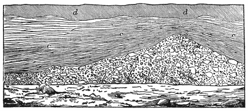
Another important fact respecting this glacial draft consists in the universal absence of marine, as well as fresh-water fossils in its interior—a fact which strengthens the view that they have been accumulated by the agency of strictly terrestrial glaciers; such is, at least, the case everywhere far from the sea-shore. But we may conclude that these ancient glaciers reached, upon various points, the sea-shore at the time of their greatest extension, just as they do at present in Spitzbergen and other arctic shores; and that therefore, in such proximity, phenomena of contact should be observed, indicating the onward movement of glacial material into the ocean, such as the accumulation within these materials of marine fossil remains, and also the influence of the tidal movements upon them. And now such is really the case. Nearer the sea-shores we observe distinctly, in some accumulations of the drift, faint indications of the action of the tide, reaching the lower surface of glaciers, and the remodelling to some extent of the materials which these poured into the sea. A beautiful example of the kind may be observed near Cambridge, along Charles River, not far from Mount Auburn, where the unstratified glacial drift (a) presents in its upper masses strictly the characters of true terrestrial glacial accumulation, but shews underneath faint indications (b) of the action of tides. Above, regular tidal strata (c) are observed, formed probably after the masses below had subsided. The surface of this accumulation is covered with soil (d).
The period at which these phenomena took place cannot be fully determined, nor is it easy to ascertain whether all glacial drift is contemporaneous. It would seem, however, as if the extensive accumulation of drift all around the northern pole in Europe, Asia, and America was of the same age as the erratic of the Alps. The climatic circumstances capable of accumulating such large masses of ice around the north pole, having no doubt extended their influence over the temperate zone, and probably produced, in high mountain chains, as the Alps, the Pyrenees, the Black Forest, and the Vosges, such accumulations of snow and ice as may have produced the erratic phenomena of those districts. But extensive changes must have taken place in the appearance of the continents over which we trace erratic phenomena, since we observe in the Old World, as well as in North America, extensive stratified deposits containing fossils which rest upon the erratics; and as we have all possible good reasons and satisfactory evidence for admitting that the erratics were transported by the agency of terrestrial glaciers, and that, therefore, the tracts of land over which they occur stood at that time above the level of the sea, we are led to the conclusion that these continents have subsided since that period below the level of the sea, and that over their inundated portions, animal life has spread, remains of organized beings have been accumulated, which are now found in a fossil state in the deposits formed under those sheets of water.
Such deposits occur at various levels in different parts of North America. They have been noticed about Montreal, on the shores of Lake Champlain, in Maine, and also in Sweden and Russia; and what is most important, they are not everywhere at the same absolute level above the surface of the ocean, shewing that both the subsidence and the subsequent upheaval which has again brought them above the level of the sea, have been unequal; and that we should therefore be very cautious in our inferences respecting both the continental circumstances under which the ancient glaciers were formed, and also the extent of the sea afterward, as compared with its present limits.
The contrast between the unstratified drift and the subsequently stratified deposits is so great, that they rest everywhere unconformably upon each other, shewing distinctly the difference of the agency under which they were accumulated. This unconformable superposition of marine drift upon glacial drift is so beautifully shewn at the above-mentioned locality near Cambridge (see diagram, p. 114.) In this case the action of tides in the accumulation of the stratified materials is plainly seen.
The various heights at which these stratified deposits occur, above the level of the sea, shew plainly, that since their accumulation the main land has been lifted above the ocean at different rates in different parts of the country; and it would be a most important investigation to have their absolute level, in order more fully to ascertain the last changes which our continents have undergone.
From the above mentioned facts, it must be at once obvious that the various kinds of loose materials all over the northern hemisphere, have been accumulated, not only under different circumstances, but during long-continued subsequent distinct periods, and that great changes have taken place since their deposition, before the present state of things was fully established.
To the first period,—the ice period, as I have called it,—belong all the phenomena connected with the transportation of erratic boulders, the polishing, scratching, and furrowing of the rocks, and the accumulation of unstratified, scratched, and loamy drift. During that period the mainland seems to have been, to some extent at least, higher above the level of the sea than now; as we observe, on the shores of Great Britain, Norway, and Sweden, as well as on the eastern shores of North America, the polished surfaces dipping under the level of the ocean, which encroaches everywhere upon the erratics proper, effaces the polished surfaces, and remodels the glacial drift. During these periods, large terrestrial animals lived upon both continents, the fossil remains of which are found in the drift of Siberia, as well as of this continent. A fossil elephant, recently discovered in Vermont, adds to the resemblance, already pointed out, between the northern drift of Europe and that of North America; for fossils of that genus are now known to occur upon the northern-most point of the western extremity of North America, in New England, in Northern Europe, as well as all over Siberia.
To the second period we would refer the stratified deposits resting upon drift, which indicate, that during their deposition the northern continent had again extensively subsided under the surface of the ocean.
During this period, animals, identical with those which occur in the northern seas, spread widely over parts of the globe which are now again above the level of the ocean. But, as this last elevation seems to have been gradual, and is even still going on in our day, there is no possibility of tracing more precisely, at least for the present, the limit between that epoch and the present state of things. Their continuity seems almost demonstrated by the identity of fossil-shells found in these stratified deposits, with those now living along the present shores of the same continent, and by the fact, that changes in the relative level between sea and mainland are still going on in our day.
Indications of such relative changes between the level of the waters and the land are also observed about Lake Superior. And here they assume a very peculiar character, as the level of the lake itself, in its relation to its shores, is extensively changed.[48]
Description of the Marine Telescope.
By John Adie, F.R.S.E., F.R.S.S.A. Communicated by the Author.
The instrument which has been popularly named the Water, or Marine Telescope, from the power given by its use to see into the water, consists of a tube of metal or wood, of a convenient length, to enable a person looking over the gunnel of a boat to rest the head on the one end, while the other is below the surface of the water; the upper end is so formed, that the head may rest on it, both eyes seeing freely into the tube. Into the lower end is fixed (water-tight) a plate of glass, which, when used, is to be kept under the surface of the water.
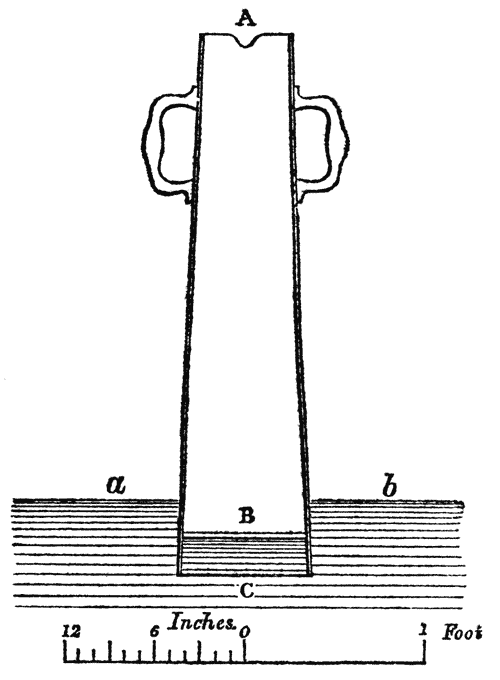
A very convenient size for the instrument represented in the above figure, is to make the length AC, 3 feet, and the mouth A, where the face is applied, of an irregular oval form, that both eyes may see freely into the tube, with an indentation on one side, that the nose may breathe freely, not throwing the moisture of the breath into the tube. B is a round plate of glass, 8 inches diameter, over which is the rim or edge C; this rim is best formed of lead, ¼ of an inch thick, and 3 inches deep; the weight of the lead serves to sink the tube a little into the water. Holes must be provided at the junction of B to C, for the purpose of allowing the air to escape, and bring the water into contact with the glass; on each side there is a handle for holding the instrument. This size and form is very much that of the instrument brought from Norway by John Mitchell, Esq., Belgian Consul, of Mayville, with the improvement for excluding the breath, and allowing the water to get into contact with the glass, which was not provided for in that instrument.
The reason why we so seldom see the bottom of the sea, or of a pure lake, where the depth is not beyond the powers of natural vision, is not that the rays of light reflected from the objects at the bottom are so feeble as to be imperceptible to our sense, from their passage through the denser medium of the water, but from the irregular refractions given to the rays in passing out of the water into the air, caused by the constant ripple or motion of the surface of the water, where that refraction takes place. Reflections of light from the surface also add to the difficulty; and before we can with any just hope expect to see the objects distinctly at the bottom, these obstructions must be removed.
This is done to a very great extent by the use of the instrument which forms the subject of this notice; the tube serves to screen the eyes from reflections, and the water being in contact with the glass plate, all ripple is got rid of, so that the spectator, looking down the tube, sees all objects at the bottom, whose reflective powers are able to send off rays of sufficient intensity to be impressed on the retina, after suffering the loss of light caused by the absorbing power of the water, which obeys certain fixed laws, proportionate to the depth of water passed through; for as light passing through pure sea-water loses half its intensity for each 15 feet through which it passes,[49] we must, from this cause alone, at a certain depth lose sight of objects of the brightest lustre. The perfect purity of the water, and its freedom from all muddy particles floating in it, form an important element in the effective use of the water-telescope; for example, in the Frith of Forth, and similar estuaries, where the influx and reflux of the tide keep particles of mud in constant motion, the instrument is of little or no use; for these act in exactly the same way in limiting our vision through water, as a fog does through the air: it is therefore only in the pure waters of our northern and western shores that this contrivance is applied with any advantage; and in such situations we can speak of its powers with confidence. In a trial made with the instrument last autumn on the west coast of Scotland, the bottom was distinctly seen (a white bottom) at a depth of 12 fathoms; and on a black, rocky bottom, at 5 fathoms under water, objects were so distinctly seen that the parts of a wreck were taken up—the exact place of which was not known previous to its use. In these experiments a lenticular form of glass was made use of at the bottom of the tube, having a plane surface to the water, but no great or marked advantage was observable from this construction. With respect to the history of this contrivance for viewing the bottom of the sea, we are unable to assign any particular date: so far as our information goes, it has been in use from a very remote period. We are informed that it is in general use in seal-shooting along our northern and western islands, where, sometimes in the form of an ordinary washing-tub, with a piece of glass fixed in its bottom, the shot-seal was looked for, and the grappling-hook let down to bring him to the surface. It may not be generally known, that in seal-shooting, the shot or wounded seal always seeks the bottom, from which he never rises after death, till washed ashore by the action of the sea: it is only when the fatal ball deprives him of the power of diving that he is ever found at the surface. In such employments, therefore, the use of this instrument, however modified, must form an important auxiliary to the best rifle. Throwing oil over the surface of the water is used in the same pursuits; but this only so far stills the ripple, leaving the reflections. Our eminent engineer, Mr Robert Stevenson, made use of the water-telescope more than 30 years ago, in works connected with harbour improvement in the north of Scotland; it has also been used to examine the sand-banks, &c., at the bottom of the River Tay, but in this case the mud prevented its use in any considerable depth of water. To obviate this difficulty, the construction was modified thus: by making the tube of considerable length, and placing the glass at the lower end, this tube was thrust through the water till within a few feet of the bottom, acting as a cofferdam to set aside the dirty water, and enable the bottom to be seen; but in this method of application it was found very difficult to hold the tube down in the water from its buoyant power, and we are informed by Mr Thomas Stevenson, C. E., that, he understood from this cause its use had been discontinued. He suggested a simple remedy; viz., to fill up the empty tube with pure water. We are indebted to Mr Mitchell, the gentleman already mentioned, for having brought this instrument into notice in the public prints, under the name of Norwegian water-telescope, on the shores of which country it is stated to be much used in fishing—in particular, that of the herring; but the herring-fishers on the east coast of Scotland inform us, that they require no such auxiliary, as, from the surrounding elevated grounds, they can tell the position of the shoal, and, from their motions seen from such situations, they know where they are to be found when they go out a-fishing.[50]
The water-telescope is thus noticed in a very promising periodical, the American Annual of Scientific Discovery, just published, of which a copy reached us a few days ago.—Ed. Phil. Journal.
The water-telescope is an instrument which the people of Norway have found of so great utility, that there is scarcely a single fishing-boat without one of three or four feet in length, which they carry in their boats with them when they go a-fishing. When they reach the fishing-grounds, they immerse one end of this telescope in the water, and look through the glass, which shews objects some ten or fifteen fathoms deep as distinctly as if they were within a foot of the surface. When a shoal of fish comes into their bays, the Norwegians instantly prepare their nets, man their boats, and go out in pursuit. The first process is minutely to survey the ground with their glasses, and where they find the fish swarming about in great numbers, they give the signal, and surround the fish with their large draught-nets, and often catch them in hundreds at a time. Without these telescopes their business would often prove precarious and unprofitable; as the fish, by these glasses, are as distinctly seen in the deep, clear sea of Norway, as gold-fish in a crystal jar. This instrument is not only used by the fishermen, but is also found aboard the navy and coasting-vessels of Norway. When their anchors get into foul ground, or their cables warped on a roadstead, they immediately apply the glass, and, guided by it, take steps to put all to rights, which they could not do so well without the aid of the rude and simple instrument, which the meanest fisherman can make up with his own hands, without the aid of a craftsman. This instrument has been lately adopted by the Scotch fishermen on the Tay, and, by its assistance, they have been enabled to discover stones, holes, and uneven ground, over which their nets travel, and have found the telescope answer to admiration, the minutest object in twelve feet of water being as clearly seen as on the surface. We see no reason why it could not be used with advantage in the rivers and bays of the United States.
Experimental Investigations to Discover the Cause of the Change which takes place in the Standard Points of Thermometers.
By John Adie, F.R.S.E., F.R.S.S.A. Communicated by the Author.
It has long been known to experimentalists that, in thermometers constructed with the greatest care, a change takes place after a lapse of time in the standard points, as given by the melting of ice and boiling of water under a fixed pressure; on this account it has been recommended by most writers, where the employment of thermometers is treated of, that they should from time to time be compared one with another, and also at the freezing point. This change is a rising of the mercury in the tube, so that, after a length of time, the mercury will not sink to the point laid off in the construction of the instrument. To investigate to what cause this change was due, formed the object of my experiments: Was it a change in the glass of which the bulbs are formed, or in the mercury with which they are filled? I was aware that thermometers filled with alcohol were not subject to this change, which would lead to the inference, that the change was in the mercury and not the glass; but then, in the spirit-thermometer, air is left above the column of spirit, whereas, in those constructed with mercury, the air is expelled, and there is a vacuum above the column; consequently, the bulb is pressed together with the force of an atmosphere on all sides; might not this force, acting for a length of time, cause some small alteration in the arrangement of the particles forming the glass of the bulb?
This is the explanation accepted by most of the Italian and French writers on this subject. Some suppose that the mercury may contain air and moisture within its particles; but such a hypothesis I think inadmissible, as in the case of a vacuum over the mercury, these particles would seek the void, and cause rather a depression than a rising of the freezing point. Mr Daniell, in his Essay on Climate, adopts the same view; and Sir John Herschel, in his article Heat, in the Encyclopædia Metropolitana, says: The freezing point upon the mercurial thermometer has been supposed to undergo some slight variation, so as to appear too low upon the scales of those instruments which have been long made; and it is said that, in such cases, the just indication was again recovered by breaking off the end of the stem, so as to admit atmospheric air. But, as I had observed that the change went on for a time only, after which it ceased, and that it affected thermometers sealed with air over the mercury, as well as those with a vacuum, I undertook the following experiments:—
In September 1848 I made four thermometers having long degrees,—such that 1/10° might be easily noted, constructed of the same draft of glass tube; two of these I placed in boiling water, and kept them at that temperature for a week: my object in this was to learn if any change in the form of the bulb would take place from this slow process of annealing, as glass is known to undergo some change from such exposure.
The four thermometers were now filled with pure mercury: two of these were sealed with a vacuum over the mercury; one tube that had been boiled, and the other not: the other two tubes were sealed with air over their columns, and the freezing points of all were marked on the tubes; after which they were placed in a window freely exposed to light, where they were left till January 1849—a space of four months—when they were again placed in melting ice, and the freezing points marked; they had risen ·24°, ·24°, ·20°, ·06° parts of a degree. The whole four thermometers were now placed in boiling water, and kept there for a week, when the freezing points were again observed to have risen respectively ·48°, ·41°, ·50°, ·45°.
The instruments were now left exposed to light as at first; and, in January 1850, the freezing points were again observed, when they were found to have farther risen ·12°, ·18°, ·20°, ·13°; and, lastly, they were observed in May 1850, when no change from last observation was notable.
The whole amount of rising of the freezing point in these four thermometers, after a lapse of eighteen months, is respectively ·84°, ·83°, ·90°, ·65°; and these changes may be the full amount that would take place were the instruments observed after a greater lapse of time. From my experience, I know that there is a period after which no change takes place; but, from the method in which these experiments have been conducted, I am not at present in a condition to assign a time; moreover, it is evident that this period will be much modified by circumstances. The results above stated form the following Table:—
No.Description of Thermometer. Value of one Degree of Fahr. Observed rise, Jan. 1849. Rise after having been boiled for a week Rise at Jan. 1850. Total rise.
1.Sealed in vacuum, not boiled. 0·1660·240·480·120·84
2.Sealed in vacuum and boiled. 0·1680·240·410·180·83
3.Sealed with air, not boiled. 0·1990·200·200·200·90
4.Sealed with air, boiled. 0·1540·060·130·130·65
From inspection of the Table, no very remarkable difference is observable in the rising of these four instruments. No. 4 appears to have risen less during the first period, but goes along with the others afterwards. The effect of exposure to the temperature of boiling water shews that, under high temperature, the change goes on much faster than at the ordinary temperature of the air; from the Table it will be observed, that about twice the amount of change was caused by the boiling of the thermometers for a week, than had taken place between the first and second observations, a period of four months.
It does not appear that the boiling of the thermometer tubes for eight days, previous to their being filled with mercury, had produced any change on the form of the bulbs; we should at least infer this from the change in their freezing points keeping pace so nearly with those which had not been boiled.
I now come to the concluding experiment with these instruments, and, it appears to me most interesting and anomalous. The four tubes being placed in pounded ice, the columns stood at the points indicated in the last column of the Table; in this situation the tops of the tubes were broken off, so as to admit the free pressure of the air, and instantly the thermometers fell, in the order of their numbers, ·54, ·43, ·40, ·35 of a degree, now indicating on their scales +·30, +·40, +·50, +·35. The remarkable features shewn by this experiment are; first, that the two thermometers sealed with vacuum, and the two having air over their columns, should have risen nearly equally, when two had their bulbs pressed with the whole force of an atmosphere, while the other two had no pressure externally, farther than that caused from changes in the pressure of the atmosphere. Next, that on being opened, those with air over them should have started down nearly as much as those with a vacuum; and on all these appears a permanent change from three to five-tenths of a degree. I confess that I am very much at a loss to account for these singular changes; atmospheric pressure on the bulbs would account for the change in those sealed with a vacuum; for we can easily suppose that a permanent form had been taken from long exposure to that pressure by the glass forming the bulbs: besides this permanent form, there appears to have been a spring inwards, which instantly sprung out on removal of the pressure by the admission of air over the mercury; but the same reasoning will not apply to the thermometers having air over the mercury; and before I attempt to make any suggestions as to the cause of these changes, I propose to institute the following experiments. Having had three thermometers blown and filled with mercury, I shall make one with a perfect vacuum over the mercury, the next with air over it, and the third with air condensed over it; and, noting the changes that may go on in these, I hope to be able to assign a cause or causes for the change. It is argued by some continental writers on this subject that the reason why we do not perceive any change in the freezing point in spirit-thermometers is from the great expansion of spirit above mercury, volume for volume, thereby requiring a much smaller mass of fluid to give the same length of a degree: this I propose to test by making a thermometer with the same size of tube and bulb as those to be experimented on with mercury. In mentioning these experiments to Professor Forbes, he kindly put me in possession of some spirit-thermometers, one of these, made in 1837, having a very large bulb—this, with three others, shewed no change in the places of their freezing points.
Observations on the Discovery, by Professor Lepsius, of Sculptured Marks on Rocks in the Nile Valley in Nubia; indicating that, within the historical period, the river had flowed at a higher level than has been known in Modern Times.
By Leonard Horner, Esq., F.R.S.S. L. & E., F.G.S., &c. Communicated by the Author. With a Plate.
The recent archaeological[N7] researches of Professor Lepsius in Egypt, and the Valley of the Nile, in Nubia, have given a deserved celebrity and authority to his name, among all who take an interest in the early history of that remarkable portion of the Old World. While examining the ruins of a fortress, and of two temples of high antiquity at Semne, in Nubia, he discovered marks cut in the solid rocks, and in the foundation-stones of the fortress, indicating that, at a very remote period in the annals of the country, the Nile must have flowed at a level considerably above the highest point which it has ever reached during the greatest inundations in modern times. This remarkable fact would possess much geological interest with respect to any great river, but it does so especially in the case of the Nile. Its annual inundations, and the uniformity in the periods of its rise and fall, have been recorded with considerable accuracy for many centuries; the solid matter held in suspension in its waters, slowly deposited on the land overflowed, has been productive of changes in the configuration of the country, not only in times long antecedent to history, but throughout all history, down to the present day. Of no other river on the earth's surface do we possess such or similar records; and moreover, the Nile, and the changes it has produced on the physical character of Egypt, are intimately associated with the earliest records and traditions of the human race. Everything, therefore, relating to the physical history of the Nile Valley must always be an object of interest; but the discovery of Professor Lepsius is one peculiarly deserving the attention of the geologist; for he does not merely record the facts of the markings of the former high level of the river, but he infers from these marks, that since the reign of Mœris, about 2200 years before our era, the entire bed of the Nile, in Lower Nubia, must have been excavated to a depth of about 27 feet; and he further speculates as to the process by which he believes the excavation to have been effected.
It will be convenient, before entering upon the observations I have to offer upon the cause assigned by Professor Lepsius for the former higher levels of the Nile indicated by these marks, that I should give the description of the discovery itself, by translating Dr Lepsius's own account of it, in letters which he addressed to his friends, Professors Ehrenberg and Böckh of Berlin, from the island of Philæ, in September 1844.[51]
"You may probably remember, when travelling to Dongola on the Lybian side of the Nile, and in passing through the district of Batn el hagér, that one of the most considerable of the cataracts of the country occurs near Semne, a very old fortress, with a handsome temple, built of sandstone, in a good state of preservation; the track of the caravan passing close to it, partly over the 4000-year-old artificial road. The track on the eastern bank of the river is higher up, being carried through the hills; and you must turn off from it at this point in order to see the cataract. This Nile-pass, the narrowest with which I am acquainted, according to the measurement of Hr. Erbkam, is 380 metres (1247 English feet) broad;[52] and both in itself, and on account of the monuments existing there, is one of the most interesting localities in the country, and we passed twelve days in its examination.
"The river is here confined between steep rocky cliffs on both sides, whose summits are occupied by two fortresses of the most ancient and most massive construction, distinguishable at once from the numerous other forts, which, in the time of the Nubian power in this land of cliffs, were erected on most of the larger islands, and on the hills commanding the river. The cataract (or rapid) derives its name of Semne from that of the higher of the two fortresses on the western bank; that on the opposite bank, as well as a poor village lying somewhat south of it, is called Kumme. In both fortresses the highest and best position is occupied by a temple, built of huge blocks of sandstone, of two kinds, which must have been brought from a great distance through the rapids; for, southward, no sandstone is found nearer than Gebel Abir, in the neighbourhood of Amara and the island of Sai (between 80 and 90 English miles), and northward, there is none nearer than the great division of the district at Wadi Haifa (30 miles distant.)
"Both temples were built in the time of Tutmosis III., a king of the 18th dynasty, about 1600 years before Christ; but the fortresses in which they stand are of a more ancient date. The foundations of these are granite blocks of Cyclopian dimensions, resting on the rock, and scarcely inferior to the rock itself in durability. They were erected by the first conqueror of the country, King Sesuatesen III., of the 12th dynasty, in order to command the river, so easily done in so narrow a gorge. The immediate successor of this king was Amenemha III., the Mœris of the Greeks: he who accomplished the gigantic work of forming the artificial lake of Mœris, in the Fayoum, and from whose time—the most flourishing of the whole of the old Egyptian kingdom—the risings of the Nile in successive years, doubtless by means of regular markings, as indeed Diodorus tells, remained so well known, that, according to Herodotus, they were recorded in distinct numbers from the time of Mœris. It appears that this provident king, occupied with great schemes for the welfare of his country, considered it of great importance that the rising of the Nile on the most southern border of his kingdom should be observed, and the results forthwith communicated widely in other parts of the land, to prepare the people for the inundations. The gorge at Semne offered greater advantages for this object than any other point; because the river was there securely confined by precipitous rocky cliffs on each side. With the same view he had doubtless caused Nilometers to be fixed at Assuan and other suitable places; for without a comparison with these, the observations at Semne could be of little use.
"The highest rise of the Nile in each year at Semne, was registered by a mark, indicating the year of the king's reign, cut in the granite, either on one of the blocks forming the foundation of the fortress, or on the cliff, and particularly on the east or right bank, as best adapted for the purpose. Of these markings eighteen still remain, thirteen of them having been made in the reign of Mœris, and five in the time of his two next successors. These last kings discontinued the observations; for, in the meantime, the irruption of the Asiatic pastoral tribes into Lower Egypt took place, and wellnigh brought the whole kingdom to ruin. The record is almost always in the same terms, short and simple: Ra en Hapi em renpe ... mouth or gate of the Nile in the year.... And then follows the year of the reign, and the name of the king. It is written in a horizontal row of hieroglyphics, included within two lines—the upper line indicating the particular height of the water, as is often specially stated—
"The earliest date preserved is that of the sixth year of the king's reign, and he reigned 42 years and some months. The next following dates are, the years 9, 14, 15, 20, 22, 23, 24, 30, 32, 37, 40, 41, and 43; and include, therefore, under this king, a period of 37 years. Of the remaining dates, that only of the 4th year of his two successors is available; all the others, which are on the west or left bank of the river, have been moved from their original place by the rapid floods which have overthrown and carried forward vast masses of rock. One single mark only, that of the 9th year of Amenemha, has been preserved in its original place on one of the building stones, but somewhat below the principal rapid.[53]
"We have now to consider the relation which these—the most ancient of all existing marks of the risings of the Nile—bear to the levels of the river in our own time. We have here presented to us the remarkable facts, that the highest of the records now legible; viz., that of the 30th year of the reign of Amenemha, according to exact measurements which I made, is 8·17 metres (26 feet 8 inches) higher than the highest level to which the Nile rises in years of the greatest floods; and further, that the lowest mark, which is on the east bank, and indicated the 15th year of the same king, is still 4·14 metres (13 feet 6½ inches); and the single mark on the west bank, indicating the 9th year, is 2·77 metres (9 feet) above the same highest level.
The mean rise of the river, recorded by the marks on the east bank, during the reign of Mœris, is 19·14 metres (62 feet 6 inches) above the lowest level of the water in the present day, which, according to the statements of the most experienced boatmen, does not change from year to year, and therefore represents the actual level of the Nile, independently of its increase by the falls of rain, in the mountains in which its sources are situated. The mean rise above the lowest level, at the present time, is 11·84 metres (38 feet 8 inches); and, therefore, in the time of Mœris, or about 2200 years before Christ, the mean height of the river, at the cataract or rapid of Semne, during the inundation, was 7·30 metres (23 feet 10 inches) above the mean level in the present day.
Such are the facts recorded by Dr Lepsius; and then follow, in the same letter, his views as to the cause of the remarkable lowering of the level of the river.
There is certainly no reason for believing, he says, "that there has been any diminution in the general volume of water coming from the south. The great change in the level can, therefore, only be accounted for by some changes in the land, and these must also have altered the whole nature of the Nile Valley. There seems to be but one cause for the very considerable lowering of the Nile; namely, the washing out and excavations of the catacombs (Answaschen und Aushölen der Katakomben); and this is quite possible from the nature of the rocks themselves, which, it is true, are of a quality that could not well be rent asunder, and carried away by the mere force of the water, but might be acted upon directly by the rising of the water-level, and the consequent effects of the sun and air on the places left dry, causing cracks, into which earth and sand would penetrate, which would then give rise to still greater rents, until, at last, the rocks would of themselves fall in, by having been hollowed out, a process that would be hastened in those parts of the hills where softer and earthy beds existed, and which would be more easily washed away. But that, in historical times, within a period of about 4000 years, so great an alteration should take place in the hardest rocks, is a fact of the most remarkable kind,—one which may afford ground for many other important considerations.
"The elevation of the water-level at Semne must necessarily have affected all the lands above; and, it is to be presumed, that the level of the province of Dongola was at one time higher, as Semne cannot be the only place in the long tract of cliffs where the bed of rock has been hollowed out. It is to be conceived, therefore, that not only the widely-extended tracts in Dongola, but those of all the higher country in Meroë, and as far up as Fasogle, which, in the present day, are dry and barren on both sides of the river, and are with difficulty irrigated by artificial contrivances, must then have presented a very different aspect, when the Nile overflowed them, and yearly deposited its fertile mud to the limits of the sandy desert.
"Lower Nubia also, between Wadi Haifa and Assuan, is now arid almost throughout its whole extent. The present land of the valley, which is only partly irrigated by water-wheels, is, on an average, from 6 to 12 feet higher than the level to which the Nile now rises; and although the rise at Semne might have no immediate influence upon it, yet what has occurred there makes it more than probable, that at Assuan there was formerly a very different level of the river, and that the cataracts there, even in the historical period, have been considerably worn down. The continued impoverishment of Nubia is a proof of this. I have no manner of doubt that the land in this lower part of the valley, which, as already stated, is at present about 10 feet above the highest rise of the Nile, was inundated by it within historical time. Many marks are also met with here, that leave no doubt regarding the condition of the Nile Valley antecedent to history, when the river must have risen much higher; for it has left an alluvial soil in almost all the considerable bays, at an average height of 10 metres (32 feet 9 inches) above the present mean rise of the river. That alluvial soil, since that period, has doubtless been considerably diminished in extent by the action of rain. On the 17th of August Hr. Erbkam and I measured the nearest alluvial hillock in the neighbourhood of Korusko, and found it 6·91 metres (22 feet 7 inches) above the general level of the valley, and 10·26 metres (33 feet 7 inches) above the present mean rise of the river. That rise, which at Semne, on account of the greater confinement of the stream between the rocks, varies as much as 2·40 metres (7 feet 10 inches) in different years, varies at Korusko less than 1 metre (3 feet 3 inches).