PHILOSOPHICAL JOURNAL. (continued 2)
Reading edition
On the north, and to the east of Lussan, the mountains of Idumæa are lofty, consisting of precipitous limestone ranges; the solitary conical mount, about 600 feet above the plain, named Gebel Araif-el-Naka—the crest of a she-camel, forms a conspicuous object; it is calcareous, and strewed with flints. Low ridges extend from it westward and eastward; the latter terminating in a headland or bluff, called Gebel Makrah.
The wide sandy Wadi-el-Ghudhagidh—the Ghudhaghidh of Robinson—is probably the Gudgodah; or, as it is written in Hebrew, Ghudghodah, mentioned in Deut. x. 7, whither the Israelites journeyed from Mosera (Wadi Mousa) after Aaron's death. After this valley were some low chalky cliffs, and then succeeded a barren flinty tract.
Towards the NW. and W., a broad open district stretches out apparently to Gebel Jaraf, said to be 1300 feet above the sea level, through which is the course of the Wadi Khereir, elevated about 1000 feet at its nearest point to that mount, and flowing northward into the large Wadi-el-Agaba,—upon one side, and to Gebel Yelak, the white mountain, on the other side; but it is broken in some places by limestone or chalk hills.
The Wadi Ghudhagidh, and the more southern tributaries of the Jerafah, flow to the NE. to the Dead Sea, as already explained; and they, with some smaller winter torrents that unite with them, are the only water-courses in this part of Arabia Petræa which supply that sea. On the SE. of the upper Jerafah, some low limestone ridges present themselves; but, on the other side is the sandy plain El Adhbeh: beyond this, northwards, follows a level plain covered with pebbles and black flints. The high West Desert, called by the Arabs El Tyh, the wandering, and so named in Edrisi and Abul-feda, near its centre at Nakhl, signifying date trees (at which station there exists a grove of those trees), at an elevation of near 1500 feet above the sea, consists of vast plains, or plateaux of varying, mostly higher, altitudes, a sandy, flinty, or gravelly soil, and limestone hills of the cretaceous or secondary formation, having very irregular ridges disposed in different directions.
The numerous Wadis, or water-courses, and winter torrents of this enormous desert, all run to the N. or NW., and pour their waters into the Mediterranean Sea; while those Wadis that lie on the other side of the Great Mountain range, which bounds the desert in its western and southern extremities—Gebel-el-Rahah and Gebel-el-Tyh—divide their waters, and so supply, in part, the Gulf of Suez, and in part the Gulf of Akaba. Of the former Wadis, two are the principal; namely, Wadi-el-Agaba, which rises somewhat to the east of the line of 34° E. long.; and Wadi-el-Arish, which Russegger and later authors affirm as springing to the west of it, and of Gebels Heiyalah, Yelak, and Mishea, and of which Wadi Nesil seems to me to be only a tributary.
The chain called Gebel-el-Egmeh, or El Odjme by Burckhardt, appears, as he says, chalky; and such, also, is the soil of the plain, and frequently covered with black pebbles (flints); it unites with the higher chain of the Gebel-el-Tyh, about the centre of the Peninsula,—that is to say, of the Peninsular Triangle, and where the branches North-el-Tyh and South-el-Tyh separate. There the height of the summit of El Tyh is given by Russegger as 4322 Paris feet, or 4615 English feet, above the sea; descending thence by the pass of Mureikhi, into the sandy plain of Debbet-el-Ramleh, the elevation of that plateau, just about the middle of it, and about half way to the head of Wadi-el-Sheikh, is near 4000 feet above the sea level; Alahadar being a little to the east.
In the Wadi El Sheikh, meaning the Valley of the Elder, or Chief, which is one of the principal valleys in the Peninsula, before coming to Moses' seat (Mokad Seidna Mousa), occurs a range of low hills of a substance called Taffal, chiefly a detritus of the felspar of granite, like pipe clay. The easiest approach to the present Sinaic district is by the east side of this Wadi, which leads into the wider Wadi, or plain El Raha, i.e., a plain surrounded by hills. The view of Gebels El Deir (The Convent), the now-termed Horeb, Humer (red), and others, from thence is very striking. The lower granitic mountains of the present Sinai are more regularly shaped than the upper; being less rugged, they have no insulated peaks; and their summits terminate in smooth curves. Whilst in the ascent to the higher mountains, peaks on peaks arise, of the form of sharp cones, and of various altitudes. Gebel Mousa, or Moses' Mount, is of red granite for about half-way up; all the rest being a yellowish granite, with small black grains, and from Wadi Leja (asylum), these colours appear most distinct. The height of the apex of G. Mousa peak, which does not exceed fifty yards in width, was ascertained by Lieutenant Wellsted, from the mean of observations, to be 7505 feet above the sea of Akaba; and that late, able, and lamented officer, who was upon that summit in January, and enjoyed the advantage of a clear serene atmosphere, which, in a more advanced season of the year, would have been hazy, with a blue mist, arising from the powerful sun, was thereby enabled, by means of angles taken to the hills on the Arabian coast, ninety miles distant, to correctly fix the geographical position of the mountain. He has also well described the most extensive view from that peak, as follows:—
The Gulfs of Suez and Akaba are distinctly visible; from the dark-blue waters of the latter, the island of Tiran, considered by the ancient geographers as sacred to Isis,[13] rears itself. Mount Agrib (Garib), on the other hand, points out 'the land of bondage.' Before me is St Catherine, its bare, conical peak now capped with snow. In magnificence and striking effect, few parts of the world can surpass the wild, naked scenery everywhere met with in the mountain-chain which girds the sea-coast of Arabia. ... The monkish Mount Sinai itself, and the hills which compose the district in its immediate vicinity, rise in sharp, isolated, conical peaks. From their steep and shattered sides huge masses have been splintered, leaving fissures rather than valleys between their remaining portions. These form the highest part of the range of mountains that spread out over the Peninsula, and are very generally, in the winter months, covered with snow, the melting of which occasions the torrents which everywhere devastate the plains below. The peculiarities of its conical formation, render this district yet more distinct from the adjoining heights that appear in successive ridges beyond it, while the valleys which intersect them are so narrow that few can be perceived. No villages and castles, as in Europe, here animate the picture; no forests, lakes, or falls of water, break the silence and monotony of the scene. All has the appearance of a vast and desolate wilderness, either grey, darkly-brown, or wholly black.[14]
And Dr Lepsius remarks on this mountain, that—
Although it is certainly a high mountain, still it is a secondary one, and almost eclipsed by others of the Great Southern Chain, the geographical centre of which is neither in Gebel Mousa, nor the loftier Gebel Katherin, but in the more southern, and considerably more elevated Gebel-um-Schomar.
Gebel Katherin, composed principally of a coarse red granite, presents the same conical peaks. But in Wadi Owasz, S. by W., from the last mountain, Burckhardt noticed a small chain of white and red sandstone hills in the midst of granite.
Gebel-um-Schomar (Mount Mother Schomar), also consists chiefly of granite; the lower part red, but the top is almost white. In its middle, between the granite, occur broad layers of brittle black slate, mixed with veins of quartz and felspar, and with micaceous schist. Its extreme peak, about 8800 feet above the sea, is sharp pointed, and seems to be inaccessible, owing to its perpendicular and smooth sides. Burckhardt, in his attempt to ascend it, was obliged to halt at about 200 feet below it. This was, until recently, esteemed the highest point in the Peninsula; but, according to Herr Russegger, two or three other peaks, to the south of it, are about 500 feet more lofty; the extreme elevation of this last group, which seems not to bear any distinct appellation, he estimates at 9300 English feet.
I here add, after the latter author, a sketch of the granite peaks of the high Modern-Sinaic mountains, from north to south, as they present so interesting and remarkable an appearance.
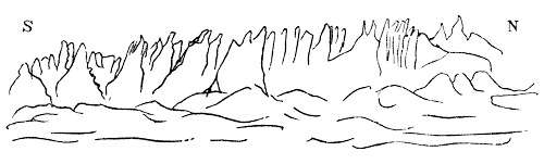
In the narrow valley, a little south of Gebel Mohala, which is all granite, on the east side of, or opposite to, the Schomar, is a spring named Tabakat, where beautiful porphyry is observed.
The south side of Mount Schomar is very abrupt, and there is no secondary chain between it and the other lofty southern mountains, and the long gravelly plain El Kaa.
From that plain, entering Wadi Hebron—a ravine about 100 yards wide—fragments of rocks, principally of granite and porphyry washed down by torrents, are frequent; a small stream is seen flowing among them; in spots, some date trees occur, and likewise the manna-producing tamarisk. Continuing to ascend, a moderately-steep pass is reached; afterwards, a descent of about 700 feet leads into the sandy Wadi Solaf wine valley; and then, gaining, with some difficulty, the summit of a steeper pass, the north-west angle of the extensive Wadi Raha is come to. Here, again, the present Sinaic group, beyond the plain, exhibits its rugged mountains of dark granite, with stern, naked, splintered peaks, and ridges of indescribable grandeur.
Next, turning to the north down the narrow declivity called Nakb Hawi, the windy pass, of which the stupendous granite walls or cliffs elevate themselves to about 800 feet, passing to the west end of Wadi Solaf, where it meets Wadi Firan and Wadi-el-Sheikh, and following the last valley as far as El Szaleib, that ascent is attained. There the formation consists of granite, on the upper beds of which run layers of red felspar. North-east of Wadi-el-Ush is situate Gebel Sheyger, which affords some native cinnabar. The three principal passes leading from the sandy Debbet-el-Ramleh on to the great desert over the Tyh range, are, El Mureikhi near the centre and near Gebel-el-Egmeh; then El Warsah, said to be of too rapid an ascent for caravans; and the third, which is most to the west, El Rakineh (the painted.) Afterwards, at some distance to the NW., is the valley opening past Ras Wadi Gharandel, that has already been described.
Proceeding, again, across the plain El Ramleh, and over the pass Mureikhi on to the Desert-el-Tyh, in the approach to the castle of Nakhl, on the east, a few miles off, low chalky hills appeared; and in places there were holes wherein rock-salt had been dug. The water at Nakhl is brackish, and the ground chalky, covered with loose pebbles. Wadi Nesil was observed to be overgrown with green shrubs. Gebel-el-Thughar, signifying the mouths, presents a mountainous tract, in which followed a valley with calcareous hills: here deep sands were lodged, and large insulated rocks of a porous tufa, called by Burckhardt tufwacke, lie scattered in many places.
The termination of the vast gravelly plain we had been crossing from Nakhl was now at hand; but we could yet see it spreading out wide to our left, the mirage giving its distant portions the appearance of a succession of blue lakes; directly in front were the mountains which close it in; and far to the right we could see, stretching away, a still higher range running to the north, and on the left the tops of the mountains about Wadi Gharandel, the Taset (cup) Soddur being conspicuous afar. We entered these mountains by a slight ascent, which struck soon after the head of a long winding valley descending towards Suez: the immense plain we had traversed, floated away in mist, and we had now done with the plateau of the Great Desert.[15]
Thence a plain, which is below the level of the Desert-el-Tyh, and covered with moving sands, extends as far as the sea-shore. These sands are collected by the winds, in many spots, into hills 30 or 40 feet high. The wells at Mabuk afford good water by digging to the depth of 10 or 12 feet.
Fifthly, Once more leaving Suez; after having passed over a small piece of marine and alluvial formation near the sea, and taking a westerly direction, a narrow tract of tertiary sandstone, so designated by Russegger, is observed; it is a plain which gradually ascends from the shore of the Gulf, and in it is placed the Castle of Ajroud; the water obtained there is very bitter. Beyond this to the west, the plain becomes sandy, and covered with black flints.
But the soil and hills at Wadi Emshash, which signify the Valley of the Waterpits, near Ajroud, are calcareous: the well there, called Bir Emshash, yields after rain good drinking water. The hills around Ajroud consist of tertiary limestone and marl. More to the south, Gebel Ataka divides this formation, itself being a secondary limestone belonging to the cretaceous series, and, according to Dr Robinson, is strewed thickly with flint pebbles. It terminates in Ras Ataka, or Cape Deliverance, on the Gulf. The sandy and gravelly plain, El Baidea, the Wadi Tawarik of others, has been named by some, the Valley of Moses, Wadi Mousa; it communicates on the west with Wadi-el-Tyh.
Gebel Deraj (steps) is limestone of the same cretaceous series as Mount Ataka; and this formation stretches out southwards to a great distance, constituting a large portion of the East Egyptian Desert.
Then on the south of the former mountain, a band of granite, which forms the northern ridge of Gebel Kallala, is observed, wherein there exist remains of old copper mines. Those called Reigatamerih, situate among low hills, have evidently been worked by the ancients, as well from the quantity of pottery and scoriæ there, as from the remains of miners' houses, and the regular manner in which the caverns have been cut, following up the veins.[16]
Near, on the SE., there is a well (bir) named Horreh, whose water is bad, owing to the sulphur which it contains. This is placed in Wadi Araba, an extensive valley, running in a direction nearly due W. and E., and descending from Wadi Chaderat very rapidly to the shore of the gulf, which is here termed by the Arabs Mersa Zafraneh, i.e., Harbour of Saffron. The coast itself is flat and marshy. The headlands on the south are a conglomerate, or breccia rock, of the Tertiary formation, composed of shells, stones, and other substances, held together by a calcareous cement. The Arabs report, that a carriage-road anciently existed through the Wadi Araba, and led to the Bay of Zafraneh. This, I conceive, might have been the road of communication to the Egyptian colonies and copper mines on the opposite Sinaic peninsula, in Wadi Maghara, Sarbut-el-Chadem, &c., and over which the produce of those mines, having been shipped from the harbour of Zelime to the Mersa Zafraneh, might have been conveyed in waggons to the Nile. But, whether or not the Araba mountains that rise a little to the south of the opposite coast of the Peninsula had received the same appellation from this valley, there seems to be no testimony to decide. The Monastery of St Antony—Deir Antonios—distant about 17 miles from the sea, is a fortified convent of Copts, surrounded by a strong wall, of about 35 feet in height, the entrance to which is by a trap-door, wherefrom a rope descends, as in the present Sinaic convent. The keep, or place of safety, is an insulated tower, defended by a drawbridge. According to common statement, this was the abode and place of burial of St Antony, the founder of Monachism. The mountains to the south, at the northern end of which stands the convent, are calcareous (of the same cretaceous formation), containing in places a great deal of salt. They are known to the Arabs by the term of Gebel Kallala, and, in fact, constitute the southern ridge of that chain. Another large and similarly protected convent, called Deir Bolos (Paul), distant from the former[17] about 15 miles in a direct SE. line, is situate in a picturesque place, and about 10 miles from the nearest point of the Gulf of Suez. An adjoining garden abounds in date and other fruit-trees. On the east, between this convent and the sea, Wadi Girfeh is approached, among low hills: on the tops of some of these the substructions of houses are visible, having been built with uncemented stones. Also some chambers, or catacombs, are cut in the rock: in the larger were found crystals of rock-salt; the strata are composed of limestone, and contain many fossils. Broken pieces of terra cotta vases, chiefly red, are everywhere observed; and they, with other vestiges, probably point out the site of a Roman colonial town.
Proceeding from St Paul's to the SE., for near 15 miles, the line of the primitive mountains is reached on the left, whilst the secondary chain of Gebel Kallala, consisting of limestone with ammonites, is continued on the right, or west. South of Wadi Dthahal micaceous schist approaching to gneiss occurs, and a little further, the primitive and sandstone, or gritstone rocks join. Thence the secondary, or cretaceous mountains, diverging to the south and south-west, gradually decrease in altitude.
Again, southwards, some more ancient copper-works are noticed; and then, Gebel Horvashia, whose formation is granite, rises a few miles off to the SE.; in its natural basin much good water is retained after rain. Wadi Abu Hadth next attracts attention from its possessing a good deal of fine herbage, and many gum-arabic trees. Of the granite mountains in this region, Gebel Agrib, or Garib, or Gharib (camel's hump) is the loftiest, as it elevates itself to about 6000 feet above the sea level; and from its position it forms a conspicuous landmark far out at sea.
The ascent of this majestic mountain, from its steepness and numerous ravines, is found to be fatiguing. Mr J. Wilkinson[18] describes it as follows:—
The first evening we reached the base of the highest cone, where we slept, and ascended the next morning to the summit, from which we had a view of the mountains on either side of the sea, and the different plains. We tracked the gazelles very nearly to the summit, and every now and then in the ravines found some solitary plants growing under the shade of a projecting stone. The peaks of this mountain resemble the Aiguilles near Mount Blanc; but, to equal that mountain in beauty, it requires the lower parts to be covered with the woods and verdure of the Alps, and the desert plain below to be exchanged for the green meadows of Switzerland. I calculate the height to be 5513 feet above the ravine in the plain below, which is a few hundred feet above the level of the sea.
About ten miles southward, Bir-el-Dara—the Well of Dara, below the mountain of that name, occurs; there, likewise, copper scoriæ, smelting furnaces, and miners' houses, are observed.
Further south, more copper mines are seen in a bare place, among low hills, all of which have been examined for the ore.
Advancing south-eastwards by the plain, some calcareous rocks are passed, and afterwards a line of sandstone,[19] with limestone over it, running parallel to, and nearly equidistant between the two primitive ridges. Wadi-el-Enned succeeds to the eastward, where a beautifully clear rivulet is found; but its water is too bad for the use of animals, being chiefly serviceable for the nourishment of numerous date palms. This spot lies at the foot of some limestone hills of the cretaceous series that join the eastern granitic ridge.
Next, on the south, comes Gebel Kuffra, where the water is so salt as only to be drunk by camels. Gebel Dochan, (smoke)—the Mons Porphyrites of the ancients—rising about eleven miles more southward, and in the same line with the supposed site of Myos Hormus, Μuὸς Ὅρμος, the mouse harbour, is too distant from our proposed limits, to receive a full description in the present Memoir. I will only remark that at Mount Dochan, there exist some interesting ruins, and those vast quarries, from which Rome took so many superb pieces of porphyry, to adorn her baths and porticoes.[20] On its southern side, Mr J. Wilkinson adds, we met with some Breccia Verde; and of other kinds of Breccia we had observed great quantities and varieties at Dochan. The sea-shore, about Myos Hormus, is bare and deserted; to the west, at some distance from the harbour, the granitic chain extends; on the east, between it and the sea, a low ridge of limestone hills, which unites with the primitive rocks on the north, comes down towards the shore. And, in the distance, on the north, is seen the mountain El Zeit, so called from the quantity of petroleum found there; whence project two small headlands, forming two gulfs, at the entrance of which are many long sandbanks. May not this be the 'mons Eos' of Pliny?[21]
This Gebel Zeit, or Mount of Oil, runs out into a promontory on one side of the Strait of Jubal; at its foot a copious supply of Petroleum, or rock oil, is obtained. It is about as liquid as turpentine, of a black or dark-brown colour, and is collected by the Greek Christians of Tur, who take it there and sell it, for rheumatism and for healing sores. The Arabs call it Zeit-el-Gebel—oil of the mountain.
South of this promontory the sea is studded with a number of small islands, some of which are described by Strabo; all, however, I believe, except Shadwan, which is of secondary limestone, are of recent marine formation—chiefly of Coral.
(Conclusion in our next Number.)
Synopsis of Meteorological Observations made at the Observatory, Whitehaven, Cumberland, in the Year 1849.
By John Fletcher Miller, Esq., F. R. S., F. R. A. S., &c. Communicated by the Author.
STANDARD BAROMETER,[22] Corrected and Reduced to 32° Fahrenheit.
1849.Max.Min. Mean at 3 P.M. Mean at 10 P.M. Mean Atmospheric Pressure. Range.
InchesInchesInchesInchesInchesInches
Jan.30·17328·68029·65429·67929·6661·493
Feb.30·774[23]28·89030·01230·01230·0121·884
March30·49429·14029·94029·94929·9441·354
April30·14729·12329·55129·56329·5711·024
May30·14729·05229·74929·76329·7701·095
June30·12229·51629·86729·87329·8840·606
July30·29529·21629·76329·77029·7801·079
Aug.30·18929·17529·78529·78829·8001·014
Sept.30·46428·92429·82629·83129·8421·540
Oct.30·48929·12929·72029·73129·7391·360
Nov.30·13728·73729·63729·66829·6661·400
Dec.30·721[24]29·07829·84329·83529·8531·643
Means30·34629·05529·77829·78829·7941·291 2·094
[22] The readings of the barometer hitherto used required an additive correction of about 0·08 inch. All past results will be reduced to the standard instrument.
[23] Uncorrected Maximum, 30·820 inches.
[24] Uncorrected Maximum, 30·752 inches.
STANDARD BAROMETER, Corrected and Reduced to 32° Fahrenheit.
1849. Pressure of Vapour. Mean Pressure of Dry Air.
InchesInches
Jan.0·23629·430
Feb.·26529·747
March·26429·680
April·25629·315
May·35429·416
June·35729·527
July·42629·354
Aug.·43629·364
Sept.·41329·429
Oct.·31629·423
Nov.·29529·371
Dec.·23329·620
Means·32129·473
SELF-REGISTERING THERMOMETER.
1849.Absolute Max. Min. Mean of Max.Mean of Min. Mean Monthly Temperature. Range.
°°°°° °
Jan.50·18·742·1435·8238·98731·3
Feb.51·30·45·9140·0742·99021·
March54·28·46·7939·9643·37526·
April62·29·49·7338·5144·12433·
May70·36·560·5145·8553·18533·5
June67·540·561·5348·5555·04427·
July75·546·63·9353·7458·83529·5
Aug.72·46·564·0555·0359·54125·5
Sept.74·42·562·5650·4856·52431·5
Oct.64·34·52·1643·1147·63630·
Nov.55·27·747·8542·7745·31027·3
Dec.52·525·41·6935·9338·81027·5
Means62·333·753·244·1548·69656·8
PLUVIOMETER.
1849.Rain and Snow.Snow.
InchesInches
Jan.5·683
Feb.2·045
March·837
April1·488·090
May3·037
June1·224
July5·478
Aug.3·771
Sept.2·814
Oct.5·252
Nov.4·974
Dec.2·396
Means38·999·090
1849.Wet Days.Evaporation Gauge.Prevailing Winds. Two Daily Observations.Force of Wind, 0-5.
Inches
Jan.20·909SW.3·2
Feb.121·024SW.2·1
March131·558SW. & NW.2·1
April162·620Easterly.2·5
May143·886SW.2·0
June105·076SW.1·9
July184·156NW.2·3
Aug.192·657SW.1·4
Sept.123·337E., Variable1·5
Oct.171·723SW.2·3
Nov.24·960SW.2·4
Dec.15·793E., Variable1·8
Means19028·699SW.2·1
HYGROMETER.
At 3h P.M.
1849.Mean of Dry Bulb. Mean of Wet Bulb. Mean Dew-Point Deduced.[25] Complete- ment of Dew-Point.
°°°°
January40·2839·0236·683·60
February44·6642·5040·084·46
March45·8543·1740·025·82
April48·6643·9439·139·53
May58·7952·8548·3910·40
June60·2353·4448·6811·54
July63·1357·4753·829·30
August62·4357·7754·597·84
Sept.61·9556·4852·879·08
October51·1748·1345·096·06
November46·6545·1043·233·41
December40·2538·7436·403·79
Means,52·0048·2144·917·07
1848,51·9348·2344·986·95
1847,51·9444·127·82
Weight of Vapour.
1849. In a Cubic foot of Air. Required for Saturation of a Cubic foot. Degree of Humidity, (complete Saturation =1·000). Weight of a Cubic foot of Air.
Grains.Grains.Grains.
January2·800·320·899546·2
February3·040·570·844546·8
March3·030·720·811543·7
April2·871·230·701535·1
May3·931·730·696527·2
June3·911·990·663527·8
July4·701·770·726522·6
August4·851·500·767523·2
Sept.4·551·710·728523·7
October3·580·870·804533·8
November3·410·430·888538·8
December2·710·410·878548·1
Means,3·611·100·784534·7
1848,
1847,
SOLAR AND TERRESTRIAL RADIATION.
Absolute Minima. Mean Nocturnal Temperature.
1849.Six's Thermo- meter, 4 feet above Ground.On GrassOn Wool on GrassSix's Thermo- meter, 4 feet above Ground. Naked Thermo- meters On GrassNaked Thermo- meters On Wool on GrassNaked Thermo- meters Difference
°°°°°°°
January,18·704·002·835·8230·3527·712·64
February,30·020·518·040·0735·3833·082·30
March,28·019·514·739·9634·8832·602·28
April,29·021·316·038·5132·7228·883·84
May,36·526·022·045·8539·2736·273·00
June,40·529·525·048·5541·0637·863·20
July,46·033·029·053·7445·5242·433·09
August,46·535·031·555·0349·2046·053·20
September,42·531·828·050·4842·8439·533·31
October,34·024·518·543·1137·1533·463·69
November,27·719·514·542·7737·7935·722·07
December,25·017·511·535·9330·2927·083·21
1849,33·723·518·844·1538·0435·052·98
1848,32·520·243·7935·73
1847,33·720·543·5035·95
1846,36·123·1
Terrestrial Radiation.
Maximum.Minimum.Mean.
1849.On Grass.On Wool on GrassDay.On GrassOn Wool on GrassDay.On GrassOn Wool on Grass
°°°°°
January,14·721·53d1·01·57th5·478·11
February,11·513·017th1·51·53, 22d4·696·99
March,14·516·031st0·01·511,12th5·087·36
April,11·517·511th3·03·03d5·799·63
May,12·017·51st1·52·515th6·589·58
June,14·019·54th2·03·526th7·4910·69
July,16·020·016, 17th3·04·04th8·2211·31
August,19·022·04th2·03·026th5·788·98
September,13·018·527th2·02·516, 20th7·6410·95
October,14·021·017th0·01·025, 30th5·969·65
November,10·513·224, 28th1·51·58th4·987·05
December,17·521·04th0·00·58th5·648·85
1849,14·018·41·462·166·119·09
1848,15·91·948·06
1847,15·11·14[26]7·45
1846,14·61·35[27]7·45
[26] In 1847, the Thermometer was on Cork throughout the year. It is here reduced to the Standard of Raw Wool.
[27] In 1846, the Thermometer was placed on Cork in cloudy and wet weather. The results are reduced to the Standard of Raw Wool, by adding 0°·25 to the recorded annual mean.
In Sun's Rays.
1849.Max.Mean.Solar Radiation.[28]
°°°
January,5945·503·37
February,6754·408·49
March,7761·314·51
April,9369·319·57
May,13388·027·49
June,10689·227·67
July,10696·332·37
August,10485·821·75
September,10281·118·54
October,7564·912·74
November,6750·903·05
December,5644·102·41
1849,87·069·215·99
1848,
1847,90·271·017·15
1846,
[28] Difference between the mean maximum in the Sun's rays, and the mean maximum in the shade.
Form, &c. of Instruments.
The Barometer (the frame of which is brass) is a standard made by Barrow, under the direction of James Glaisher, Esq., of the Greenwich Observatory.
The adjustment for the difference of capacity of tube and cistern is effected previous to every observation, and the correction for capillarity and reduction to the temperature of 32° is made at the close of each month.
The difference between its readings and those of the Greenwich standard is scarcely appreciable, being only 0·002 inch.
The Dry and Wet Bulb Thermometers, also made by Barrow, are considered to have identical readings under similar circumstances, and both, too, agree with the Greenwich standard thermometer. The Dew-point apparatus, now discontinued, approximates very closely in its readings to the dry and wet bulb thermometers.
The Self-registering Thermometer is a large Six made by Dollond in 1840, and its average difference from the standard is within 2/10ths of a degree. A duplicate and precisely similar thermometer (which has also been repeatedly compared with a standard at every part of the scale) is fixed by its side, so that in case of No. 1 getting out of order, No. 2 can be resorted to without detriment to the results.
These instruments all have a northern aspect, and are placed about 4 feet above the ground. The naked thermometers employed for indicating the relative amount of solar and terrestrial radiation, are precisely similar to those in use at the Government Observatories.
The Rain and Evaporation Gauges are 8 inches in diameter, and the metres are graduated to the 1/1000th part of an inch. Both are read off daily. The aperture of the rain-gauge is about 7 feet above the ground. The evaporation dish is mounted on a moveable stand, 4 feet 4 inches in height, and the circular shelf on which the vessel rests, is just large enough to hold it. The gauge receives a fair proportion of wind and sunshine, and is always exposed in the open air during the day, except when rain is falling. At night and in wet weather, it is placed under a capacious shed, 9 feet in height, and open in front. Thus, it is conceived that the evaporating surface is freely acted upon by all the circumstances concerned in promoting this important natural process.
The direction of the wind is taken twice daily, and its force is registered on an arbitrary scale from 0 to 6; the highest number is reserved for storms approaching the hurricane in violence, and is very rarely recorded.
Remarks on the Weather in 1849.
January.—A damp wet month, except the first week, when sharp frost prevailed. The mean temperature is 0°·68 above the average. On the night between the 2d and 3d, a naked thermometer on the grass fell to 4°, and one on raw wool to 2°·8 below zero, being the lowest temperature I have recorded. The radiation indicated by raw wool was 21°·5. Between one and two o'clock on the morning of the 10th, a terrific thunder-storm burst suddenly over the town, and spread great alarm amongst the slumbering inhabitants. Seven or eight dazzling discharges of the electric fluid, followed by deafening crashes, succeeded each other in about as many minutes. The storm was almost vertical; and between several of the flashes and the accompanying thunder, there was scarcely an appreciable interval, certainly not more than a single second of time. The war of the elements ceased as suddenly as it commenced, and altogether, the storm did not last more than ten minutes. The wind, which previously blew a heavy gale, lulled almost to a calm as the last peal died away. The storm was followed by a heavy fall of rain and hail. It appears to have been pretty much confined to this town and neighbourhood. Thunder was also heard on the evening of the 14th, and lightning was seen on the nights of the 21st, 26th, and 29th. Saturn's ring was perceived at this Observatory on the night of the 31st, after a long continuance of damp, wet weather. As this singular appendage was readily seen, and was well and sharply defined, I have no doubt the instrument would have shewn it ten or fourteen days earlier, had the nights been at all favourable. The ring was also seen on the night of the 11th of September 1848, during its temporary reappearance.
February.—A fine, dry, and mild month. The temperature 3°·49 above the average of twelve years. On the 11th, the barometer attained the remarkably high point of 30·82 at this Observatory, which is about 90 feet above the sea level. At the Royal Observatory, Greenwich (40 feet above sea), the maximum was 30·85, being greater than any reading since January 1825, when the barometer at the Royal Society's apartments attained to 30·841, at 81 feet above the sea level; and there is no other instance recorded in the Philosophical Transactions of a reading so high as 30·8, from the commencement of the series in 1774. The maxima of pressure recorded on the 11th in various parts of the country, were all found to give a reading of 30·90 at the mean sea level.
On the 18th, primroses were in flower on the cliffs between Panton and Harrington.
March.—Similar to February. Temperature 2°·29 above the average, and the complement of the dew-point 2°·40 below the mean of the two preceding years.
First Quarter.—The temperature of the first quarter of 1849 is 2°·16 above the average of twelve years, and the complement of the dew-point is 1°·52 below that of the corresponding quarter in the unhealthy years 1847 and 1848.
The average fall of rain is 11·593 inches; in 1849, we have had 8·565, or 3·02 inches below the usual quantity.
The deaths in the quarter ending March 31, in the town and suburb of Preston Quarter, are 168, being 16 above the corrected quarterly average, which is 152. In the corresponding quarters of 1848 and 1849, the deaths were 250 and 187 respectively.
The deaths exceed the births by 25 in number.
April.—A fine, dry, but cold month. The temperature 1°·95 below the average. On the 23d the cuckoo was heard, and on the following day the swallow was seen in this neighbourhood. On Good Friday, the 6th, two parhelia, accompanied by a halo, were seen by a friend who was fishing by the river Calder. The sky was covered with a thin cirro-stratus, so that the images did not present any defined outline or disc, but consisted of three circular patches of light of nearly equal intensity, so much so, that it was difficult to distinguish the real from the phantom suns. The phenomena were first noticed about 5 P.M., and they remained visible till near six. The ring or halo passed through the centres of the parhelia, one of which was to the left, and the other to the right of the sun, with which they formed a straight line.
May.—A fine month, with an average mean temperature. The sun shone out on 29 days. The depth of rain is about an inch above the average quantity.
June.—A very dry month, and by far the coldest June I have recorded in the last seventeen years. The mean temperature is no less than 3°·67 below the average. The hay harvest began in this neighbourhood about the 20th.
The thermometer on the grass, on raw wool, was below the freezing point on eight nights; on the nights of the 8th and 10th it fell to 27°·5, and on that of the 19th and 20th, to 25°. On several mornings ice was seen in the immediate vicinity of the town, and on the 3d of the month there was a somewhat heavy fall of snow amongst the mountains. Highbell, Kentmere, High Street, and the mountains around Mardale, were covered with the mantle of winter to the depth of 6 inches. Such an incident has not occurred, it is said, since 1827, when several sheep were lost and smothered in snow-drifts on Mosedale and Helvellyn; and Skiddaw was covered with snow. Both snow and hail are recorded on the 10th in the register kept for me at Bassenthwaite Halls, at the foot of Skiddaw.
What is most remarkable, this unusual coldness does not appear to have been experienced at all in the southern counties of England. At Greenwich, the temperature is stated to be of the same value as that of the average from 70 years, but less than that of the preceding eight years, by 1°·9. According to Mr Glaisher's tables, published in the Registrar-General's Report for the June quarter, the mean temperature in Cornwall and Devonshire exceeds that of the corresponding month in 1847, by 0°·7, and south of lat. 52°, it is in excess 9/10ths of a degree. Between the parallels 52° and 53°, the temperature is 1°·2 below that of June 1847; between 53° and 54°, it is 2°·1, and at Whitehaven, in lat. 54½°, it is 2°·7 below that of June 1847.
The extraordinary depression in the temperature has therefore been unparticipated in, by places situated south of the parallel of 53°.
Second Quarter.—The mean temperature of the quarter ending June 30, is 1°·92 below the average of twelve preceding years; and the difference between the air and dew-point temperatures is 1°·32 above that of the corresponding quarter in the years 1847 and 1848.
The average fall of rain is 8·15 inches; in the second quarter of 1849, the fall is 5·74 inches, or 2·40 inches under the normal quantity.
The deaths in the town and suburb are 139, being 21 above the corrected average number, which is 117. In the June quarters of 1847 and 1848 the deaths were 177 and 147 respectively. The births exceed the deaths by 59.
July.—Cold and wet. Temperature 1°·82 below the average. The hay harvest began in this neighbourhood about the 20th June; meadow hay was rather light on the ground, but the crop generally was well secured.
August.—Average temperature and depth of rain, with a serene and stagnant atmosphere. The complement of the dew point is 1°·78 below the average of the month in the two preceding years.
September.—A fine, mild, and rather dry month, with serene atmosphere. At the close of the month, several of the public fountains were dry, and most of the pumps in the town had ceased to yield their supplies.
Third Quarter.—The temperature of the quarter ending September 30th is 0°·37 below the average, and the complement of the dew-point, as compared with the two previous years, is 0°·5 below the mean. The depth of rain is 0·36 inch under the average quantity, which is 12·42 inches. The deaths in the third quarter of 1849, in the town and suburb, are 168, or 47 above the corrected average number; and, except in 1846, a greater number than has occurred in any September quarter since the register was begun in 1839. In the September quarter of the last four years, the deaths are as under: 1846, 255; 1847, 148; 1848, 142; and 1849, 168. The births exceed the deaths by six in number. During this quarter we had a few cases of Asiatic cholera in this town, chiefly in the month of September; and at the adjacent seaport of Workington the disease was of a most malignant character, and exceedingly fatal. The total number of deaths from the commencement of the epidemic on the 13th of August, till it entirely ceased on the 6th of November, was 172. In 1841, the population was 6041, which gives a mortality of 2·8 per cent., or one death in every 35 persons, from cholera. It is, however, believed that the population of Workington has decreased since the last census was taken; and at the time the epidemic was raging, most of the respectable inhabitants had left the place; so that the ratio of mortality amongst the then residents must have been considerably greater than is here stated. A singular fact connected with the disease is its sudden cessation for several days, at the expiration of which it returns with increased virulence. In the week between the 25th and 31st of August, the deaths were 65; from the 31st August to the 8th September there were none; on the 8th, 12; 9th and 10th, none; on the 11th, 13; and on the 12th only one death; 13th, 11; from the 14th to the 19th inclusive, the deaths averaged 2·5 daily, but on the 20th they rose to 13; and between the 21st and the end of September there were only eight deaths, which occurred on the 21st, 22d, 25th, and 27th.
Between the 1st and 20th of October the deaths were 32, and during that period there were frequently none for three or four consecutive days. There was only one death after the 20th October. It occurred on the 6th of November, when the pestilence ceased. I am informed by a resident medical gentleman, that at the commencement of the disease the cases were rapidly fatal, many of them after eight or ten hours' illness, and it was then almost entirely confined to the lower classes.
The proximate cause of the exceedingly fatal character of the disease at this seaport is probably to be found in the effluvia engendered by the extensive tract of marshy land, called the Cloffocks, adjoining the river Derwent, and in the immediate vicinity of the town. What is most remarkable, the first case of cholera at Workington occurred on the same day of the same month, in the same house, and even in the same room in the said house, where the epidemic first broke out in the summer of 1832. There is no peculiarity in the situation of the house, nor can any reason be assigned for this most singular coincidence. I am informed that very few insects were seen about the river, and, during the height of the disease, the rooks entirely forsook their old-established quarters in the grounds adjoining the Hall.[29]
October.—Cold, with an average fall of rain (5¼ inches.) The mean temperature is 2°·5 below the average. The grain crops were above an average in point of quantity, and they were got under cover in excellent condition. Garden fruit, as pears, apples, &c., were not so plentiful as usual. On the evening of the 28th, that rare phenomenon a lunar rainbow, was seen from the grounds at Tarn Bank, near Cockermouth, by Isaac Fletcher, Esq., to whom I am indebted for the following description of it:—
In the early part of the evening the sky was clear, but at 8h 30m a dense mist rose from the river Derwent and entirely overspread a large segment of the northern horizon; whilst to the south, the atmosphere continued comparatively clear, the moon, within four days of full, shining brightly near the meridian. About 9h 10m, there was a faint luminous arch in the north, which was evidently a lunar rainbow, or rather a fog-bow, for no rain whatever was visible at the time. The light reflected by the arch was white, and perfectly free from prismatic colour. Its breadth was considerable, perhaps 4° or 5°, and its centre or highest part, passed close under the star [Greek:b] Ursæ Majoris, so that the extreme altitude of the arch was probably about 18° or 20°. The edges were not sharply defined, but gradually shaded off. It was noticed that the denser the fog became, the more apparent was the arch, and vice versa, so that the phenomenon could not have been of an auroral character. The phenomenon was watched for ten or fifteen minutes, when the gradual dispersion of the fog, by destroying the refracting medium, put an end to this interesting appearance.
November.—As usual, a very dull, damp month, with but little difference between the temperature of the days and nights. Temperature 1°·20 above the average.
Early on the morning of the 2d, a swallow was seen on the wing in the immediate vicinity of this town. The maximum temperature of the day was 55°. Between the 9th and 12th inclusive, the extremes of day and night temperature only varied 2 degrees.
December.—A fine dry month with occasional frosty nights. Temperature 2°·15, and rain 2·19 inches below the average. Two loud peals of thunder and much lightning on the night of the 14th.
The remarkable meteor observed at Edinburgh on the evening of the 19th, and minutely described by Professor Forbes who witnessed it, was also seen at Whitehaven under the same circumstances and at the same time.
Last Quarter.—The mean temperature of the last quarter of 1849 is 1°·15 below the average, and the complement of the dew-point is 0°·87 below the mean of the two preceding years. The average depth of rain for the quarter is 14·64 inches; in 1849 the quarterly fall is 12·62 inches, or 2·02 inches under the normal quantity. The deaths in this quarter, in the town and suburbs, are 131, being 4 below the average number.
It is pleasant to have to announce a favourable change in the sanitary condition of this town, and to record the termination of an excessive mortality, which uninterruptedly prevailed for a period of two years and a half; for this is the only quarterly period wherein the deaths have not exceeded the average since March 1846.
In the corresponding quarters of 1846, 1847, and 1848, the deaths were 215, 161, and 176 respectively. The births exceed the deaths by 34.
The Aurora Borealis.—There have been seven exhibitions of the aurora borealis during the year 1849, two of which were sufficiently remarkable to merit something more than a passing notice.
The first occurred on the evening of January 14th. At 10 P.M., a well-defined auroral arch, about 5° in width, extended from NNE. to W., its highest part reaching nearly to Arided in Cygnus. At 11h there was one complete arch, and segments of two other arches, all brilliant, crossing each other in the NW., and throwing off intensely bright streamers, some of which reached the altitude of the Pointers. The aurora was now exceedingly beautiful, and emitted considerable light. The streamers appeared to have a duplex lateral motion, running along the upper edge of the arch from west to north, and then backwards from north to west. The clear sky beneath the arches was almost black, from contrast. At 11h 30m the arches had broken up, and the streamers appeared to emanate from the horizon.
February 18.—At 9 P.M. there was a brilliant band of auroral light in the east about 6° in width, which shot upwards towards the zenith, throwing off short lateral streamers. At times, a complete arch of varying width extended from the eastern to the western horizon; at others, it was broken up into two or more detached portions. At 9h 45m, a magnificent rainbow-like arch about 2° in width, spanned the heavens from ENE. to WSW. The altitude of the centre was apparently about 75°; the lower edge, at or near the highest point of the arch, was bounded by the star Castor. The arch was beautifully defined, and of perfectly even width throughout its entire extent; it disappeared in a few minutes after my attention was called to it, and soon after the sky became overcast. But for the absence of the moon, it might easily have been mistaken for a lunar rainbow. A precisely similar arch made its appearance here on the evening of the 21st of March 1833, and as far as my observation goes, these perfect rainbow-like arches are of exceedingly rare occurrence.
The following phenomenon though unconnected with auroræ, is probably of electric origin; and, as an unusual atmospheric appearance, is worthy of being placed on record:—September 16.—The sky was mostly overcast throughout the day, except a segment extending from WSW. to ENE., which was bright and clear to an altitude of about 15°. The upper boundary of the clear blue space was an elliptical segment formed by a sheet of white cloud, which was partially illuminated towards the western extremity, and somewhat resembled an auroral arch. I first noticed this blue arch about 3 P.M., and from that time until it disappeared, about six o'clock, there was not the slightest apparent change, either in its altitude or position. It was observed as early as 7 o'clock in the morning, when it was, nearer to the horizon.
General Remarks.—The year 1849 is the driest we have had since 1844; the fall of rain (39 inches) is 7·9 inches under the average annual depth, which is 47 inches nearly. From some cause, the annual quantity of rain at this place is evidently on the decrease, and the diminution is, I believe, general all over the north of England. Probably the large amount of moor and waste marshy land brought into cultivation of late years, and the more efficient drainage of the country generally, by diminishing the evaporating surface, and so interfering with that invisible process of nature which is the source of every kind of atmospheric deposition, may have led to this and other changes which appear to have occurred in the climate of England within the last half century. In the first seven years (1833-39) after I began to keep a meteorological record, the average annual depth of rain was 49·93 inches, or 50 inches nearly; in the last seven years, ending with 1848, the average is reduced to 43·74 inches. The greatest quantity in the last 17 years is 59 inches, in 1836; the least, 34·69 inches in 1842. The three driest years in the period are 1842, 1844, and 1849, which yielded 34·69 inches, 36·72 inches, and 39 inches.
The temperature of the past year (48°·69) is about half a degree below the climatic mean, which is 49°·02. The coldest year of the last 17 was 1845, and the mildest, 1846; the mean temperatures of these years were 47°·49 and 50°·85 respectively.
The naked thermometer on the grass, placed on raw wool, has been at or below the freezing point in every month of 1849; viz., in January, on 19 nights; in February, on 14; in March, on 13; in April, on 18; in May, on 11; in June, on 8; in July, on 1; in August, on 2; in September, on 5; in October, on 16; in November, on 13; and in December, on 24 nights. The amount of radiant heat thrown off from the earth's crust at night, in the year 1849, as indicated by naked thermometers placed on raw wool and on grass, is much greater than usual. The evaporation exceeds the fall of rain in five months of 1849; viz., in March, April, May, June, and September. In 1849, we have had 12 perfectly clear days; 163 days more or less cloudy but without rain; 190 wet days; 261 days on which the sun shone out; 33 days of frost; 13 of hail; 7 of snow; 10 of thunder and lightning; and 7 days in which lightning occurred without thunder. There have also been three lunar halos, one lunar rainbow, a double parhelion, and seven appearances of the aurora borealis.
The clear days are 14, the days of sunshine are 13, and the wet days are 8 less than the average number. The past year has therefore afforded a smaller share of blue sky and a less amount of sunshine than usual, although the depth of rain and the number of wet days are both below the average for the locality.
The quantity of electricity in the air was extremely small down to the end of July, after which it was restored to its average amount.
This fact is strikingly exhibited by the following table of continuous observations taken by M. Quetelet with Peltier's electrometer:—
Average 1844-1848.Mean 1849.
°°
January,5339
February,4736
March,3827
April,2720
May,2116
June,1813
July,1914
August,2121
September,2424
In 1849, the deaths exceed the calculated average number by 79, and the births exceed the deaths by 74.
In the seven years ending with 1845, the mean annual number of deaths in the town and suburb, with an assumed population of 17,867, is 410, being 22·9 per thousand, or one death in every 43·5 persons. In 1846, 1847, and 1848 (assumed average population 18,329), the mean annual number is 694, being 37·8 deaths per thousand, or 1 in every 26·4 persons in those three most unhealthy years. In 1849 the deaths are 606, which, assuming the population to be the same as in 1848, give 32·2 deaths per 1000, or 1 death in every 31 persons. The average annual number of deaths in the ten years 1839-48 is 495, which, with an assumed population of 17,713, gives 27·9 per 1000, or 1 death in every 35·7 inhabitants.
So that the mortality in 1849, although still above the average, shews a marked improvement in the health of the town as compared with any of the three preceding years; and, in the last quarter, the deaths are below the average for the period.
The Observatory, Whitehaven, 13th March 1850.
The Completed Coral Island.
By James D. Dana, Geologist to the American Exploratory Expedition, &c., &c.
The Coral Island, in its best condition, is but a miserable residence for man. There is poetry in every feature; but the natives find this a poor substitute for the bread-fruit and yams of more favoured lands. The cocoa-nut and pandanus are, in general, the only products of the vegetable kingdom afforded for their sustenance, and fish and crabs from the reef their only animal food. Scanty, too, is the supply; and infanticide is resorted to in self-defence, where but a few years would otherwise overstock the half-dozen square miles of which their little world consists.
Yet there are more comforts than might be expected on a land of so limited extent, without rivers, without hills, in the midst of salt water, with the most elevated point but ten feet above high tide, and no part more than 300 yards from the ocean. Though the soil is light and the surface often strewed with blocks of coral, there is a dense covering of vegetation to shade the native villages from a tropical sun. The cocoa-nut—the tree of a thousand uses—grows luxuriantly on the coral-made land, after it has emerged from the ocean; and the scanty dresses of the natives, their drinking-vessels and other utensils, mats, cordage, fishing-lines, and oil, besides food, drink, and building material, are all supplied from it. The Pandanus, or screw-pine, flourishes well, and is exactly fitted for such regions: as it enlarges and spreads its branches, one prop after another grows out from the trunk and plants itself in the ground; and by this means its base is widened and the growing tree supported. The fruit, a large ovoidal mass, made up of oblong dry seed, diverging from a centre, each near two cubic inches in size, affords a sweetish-husky article of food, which, though little better than prepared corn-stalks, admits of being stored away for use when other things fail. The extensive reefs abound in fish which are easily captured; and the natives, with wooden hooks, often bring in larger kinds from the deep waters. From such resources a population of 10,000 persons is supported on the single Island of Taputeouea, whose whole habitable area does not exceed six square miles.[30]
Water is usually to be found in sufficient quantities for the use of the natives, although the land is so low and flat. They dig wells five to ten feet deep in any part of the dry islets, and generally obtain a constant supply. These wells are sometimes fenced around with special care; and the houses of the villages, as at Fakaafo, are often clustered about them. On Aratica (Carlshoff) there is a watering-place 50 feet in diameter, from which our vessels in a few hours obtained 390 gallons. The Tarawan Islands are generally provided with a supply sufficient for bathing, and each native takes his morning bath in fresh water, esteemed by them a great luxury.
The only source of this water is the rains, which, percolating through the loose surface, settle upon the hardened coral rock that forms the basis of the island. As the soil is white, or nearly so, it receives heat but slowly, and there is consequently but little evaporation of the water that is once absorbed.
These islands, moreover, enclose ports of great extent, many admitting even the largest class of vessels; and the same lagoons are the pearl fisheries of the Pacific.
An occasional log drifts to their shores; and at some of the more isolated atolls, where the natives are ignorant of any land but the spot they inhabit; they are deemed direct gifts from a propitiated deity. These drift-logs were noticed by Kotzebue, at the Marshall Islands, and he remarked also that they often brought stones in their roots. Similar facts were observed by us at the Tarawan group, and also at Enderby's Island, and elsewhere.
The stones at the Tarawan Islands, as far as we could learn, are generally basaltic, and they are highly valued for whetstones, pestles, and hatchets. The logs are claimed by the chiefs for canoes. Some of the logs on Enderby's Island were forty feet long, and four in diameter.
Fragments of pumice and resin are transported by the waves to the Tarawan Islands. We were informed that the pumice was gathered from the shores by the women, and pounded up to fertilize the soil of their taro patches; and it is so common, that one woman will pick up a peck in a day. Pumice was also met with at Fakaafo. Volcanic ashes are sometimes distributed over these islands, through the atmosphere; and in this manner the soil of the Tonga Islands is improved, and in some places it has received a reddish colour.
The officers of the Vincennes observed several large masses of compact and cellular basalt on Rose Island, a few degrees east of Samoa: they lie two hundred yards inside of the line of breakers. The island is uninhabited, and the origin of the stories is doubtful; they may have been brought there by roots of trees, or perhaps by some canoe.
Notwithstanding the great number of coral islands in the Paumotu Archipelago, the botanist finds there, as Dr Pickering informs me, only twenty-eight or twenty-nine native species of plants. The following are the most common of them: Portulacca, two species; Scævola Konigii. Pisonia? one species; Tournefortia sericea; Pandanus odoratissimus; Lepidium, one species; Euphorbia, one species; Morinda citrifolia; Bœrhavia, two species; Cassytha, one species; Heliotropium prostratum, Pemphis acidula, Guettarda speciosa, Triumphetta procumbens, Sauriana maritima; Convolvulus, one species; Urtica, one or two species; Asplenium nidus; Achyranthus, one species; a species of grass. One or two rubiaceous shrubs. Polypodium.
On Rose Island, Dr Pickering found only the Pisonia and a Portulacca. The Triumphetta procumbens, a creeping plant, takes root, like the Portulacca, in the most barren sands, and is very common. The Tournefortia and Scævola are also among the earliest species. The Pisonia, a tree of handsome foliage, the Pandanus, or screw-pine, and the cocoa-nut (always an introduced species), constitute the larger part of the forests. In the Marshall group, where the vegetation is more varied, Chamisso observed fifty-two native plants, and, in a few instances, the banana, taro, and bread-fruit.
The language of the natives indicates their poverty, as well as the limited productions and unvarying features of the land. All words, like those for mountain, hill, river, and many of the implements of their ancestors, as well as the trees and other vegetation of the land from which they are derived, are lost to them; and as words are but signs for ideas, they have fallen off in general intelligence. It would be an interesting inquiry for the philosopher, to what extent a race of men, placed in such circumstances, are capable of mental improvement. Perhaps the query might be best answered by another: How many of the various arts of civilized life could exist in a land where shells are the only cutting instruments? The plants, in all but twenty-nine in number,—but a single mineral,—quadrupeds, none, with the exception of foreign mice,—fresh water barely enough for household purposes,—no streams, nor mountains, nor hills! How much of the poetry or literature of Europe would be intelligible to persons whose ideas had expanded only to the limits of a coral island,—who had never conceived of a surface of land above half a mile in breadth, of a slope higher than a beach, of a change of seasons beyond a variation in the prevalence of rains? What elevation in morals should be expected upon a contracted islet, so readily overpeopled that threatened starvation drives to infanticide, and tends to cultivate the extremest selfishness? Assuredly, there is not a more unfavourable spot for moral or intellectual development in the wide world than the Coral Island, with all its beauty of grove and lake.
These islands are exposed to earthquakes and storms, like the continents, and occasionally a devastating wave sweeps across the land. During the heavier gales the natives sometimes secure their houses by tying them to the cocoa-nut trees, or to a stake planted for the purpose. A height of ten or twelve feet, the elevation of their land, is easily overtopped by the more violent seas; and great damage is sometimes experienced. The still more extensive earthquake waves, such as those which have swept up the coast of Spain, Peru, and the Sandwich Islands, would produce a complete deluge over these islands.—(United States' Exploring Expedition.—Geology.—By James Dana, p. 75.)
Biographical Notice of Leopold Pilla, the Geologist.
By H. Coquand.[31] Communicated by the Author.
Again, to bring to your recollection the numerous works which have placed Pilla among the most eminent geologists of Italy, is to do honour to the memory of an associate, whose recent loss we lament, by bestowing well-merited praises on the greatness of mind in a citizen, who nobly sacrificed a life already illustrious, and which the future promised to render still more so, to the good of his country. Yes, Italy has always been tellus magna virum! The chances of war, the rage of civil discord, the insults of foreign domination, may have eclipsed its political name, but they could not extinguish its genius. The blast of revolutions has respected the triple halo with which the sciences, letters, and the arts, have adorned its brow. By entrusting to one of his friends the task of enumerating his scientific labours, the Society imposes on him a very painful duty; but he undertakes it with feeling and gratitude; for the public homage rendered to the virtues of those whom we have loved, seems to bring them back to us, and softens the awards of destiny, which has too soon snatched them from us.
Leopold Pilla was born in the kingdom of Naples. While still young, the exciting scenes of Vesuvius attracted his attention, and determined his scientific career. In 1832, he undertook to write the annals of this volcano, and gave its history in two periodical collections.[32] It was at this period that he proved the production of flames in volcanic eruptions, and deduced from thence the ingenious conclusions which you judged worthy of a place in your memoirs.[33] This remarkable work, which of itself would have been sufficient to establish his scientific reputation, was soon followed by numerous others, which shed a new lustre on his name. The study of the extinct volcano of Rocca Monfina,[34] in the Campania, illustrated the theory of craters de soulevement, and enriched it with facts of the highest importance.
With a mind at once philosophical and cultivated, he was able to generalise and describe, to unite erudition with good taste, and to treat questions of deepest science with that grace and picturesqueness of style, which renders them popular without detracting from their accuracy. His love for geology amounted to enthusiasm; he was therefore so zealous in propagating his views, that certain jealous minds could not pardon him, and led him to atone for his fault, by a voluntary exile. The apostle of the science, he likewise was its martyr; thus nothing was wanting to his fame. It is the privilege of men of genius to be persecuted. Obliged to yield to the storm, Pilla left Naples, but by his writings he belonged to Italy at large; and the unanimous acclamation which greeted him in the chair formerly occupied by Galileo, conferred on him by the liberality of the Grand Duke of Tuscany, formed at once his triumph and revenge.
Besides the works mentioned, we owe to him a Mineralogical Treatise on Rocks;[35] an Introduction to the Study of Mineralogy;[36] and a Geological Itinerary from Naples to Vienna.[37] Thus, by approving the new productions which his activity produced, and which caused him to be better appreciated by the nation which had adopted him, the Tuscans had only to sanction the judgment they had already given of our savant, founded on his reputation and works.
Pilla left his heart at Naples. That city contained all the objects of his affections—a father, who had guided his first attempts in the field of science, and his family—a classical soil which had revealed to him the secret of its revolutions, a majestic landscape, which he could not find among the monotonous plains of Pisa, and above all his own Vesuvius. It was in this way that he recalled to his mind the mountain which had been the subject of his daily study, and from whose summit nature presented herself to his eyes in the most striking contrasts, revealing to his view its subterranean convulsions, connected with the delightful picture of the Gulf of Baia. All his thoughts brought him back to Naples. When, from the height of the terraces of Campiglia our view extended from the peaks of Mount Amiata to the banks of the Popolonia, and from the Tuscan Archipelago to the distant horizons of Corsica and Sardinia, my poor friend often interrupted our reveries by saying,—It is almost as beautiful as Naples, but my Vesuvius is wanting; and then adding, How unfortunate it is that Werner did not lay the foundation of geology at Naples; he would have made it Plutonian. Thus the love of his country, and the recollection of its wonders, were confounded in his mind with the cultivation of the science, and gave to his animated and poetical conversation a touching melancholy which agreeably tempered his vivacity.
During the years of his professorship at Pisa, Pilla published, in succession, a comparative Essay on the formations which compose the soil of Italy;[38] a Collection of the Mineral riches of Tuscany;[39] two Memoirs on the Etrurian Formation;[40] History of an Earthquake felt in Tuscany, in 1846;[41] many notices respecting the Calcare-rosso, and on the temperature observed in the wells of Monte-Massi;[42] lastly, the first volume of his Treatise on Geology.[43] The entire work would have formed four octavo volumes. The materials were prepared, but death left the work incomplete. As these various writings are in the hands of all geologists, we give no analysis of them; which indeed would only be a faint reflection from the pictures present to your memory. I may merely say, that the elevated considerations of the general physics of the globe to which he has risen in appreciating and investigating the causes of earthquakes, the comprehensive and methodical plan on which he has projected this geological treatise, by affording us a proof of the fertility and maturity of his mind, shew us, at the same time, the importance of the part reserved for a philosopher, whom death has removed from the present scene before he had reached his thirty-sixth year.
The war of independence raged at the time when Pilla was about to visit the north of Europe, in order to complete his studies in practical geology, by comparing the different formations. Every generous heart in Italy beat high at the report of the insurrection of Milan; and the Universities of Pisa and Sienna, by demanding arms and first flying to the scene of danger, shewed that hearts, proved in the fire of science, are prepared for great things. Pilla marched at the head of his pupils, and led them in the path of glory, as he had done in that of philosophy. The love of country and thirst for independence, by subjugating his heart, had stifled the calculation of reason under the impulse and delirium of enthusiasm. He had foreseen the issue of the struggle; for he said to me some days before setting out for the plains of Lombardy, the hour of our fall has struck. Italy loses by fourteen ages of servitude the splendour of her early days. They are leading us to slaughter; but we must teach our children how to die, in order that they may know how they may one day become free.
The University legion formed a small corps which was placed on the right wing of the Piedmontese army, and occupied the positions of Curtatone and Montanara. The principal effort of the Austrian army was directed against these lines, in the affair of the 29th May 1848. Attacked by 13,000 imperial troops, the Tuscans resisted courageously, and did not fall back till they had left 250 of their men on the field of battle. Their heroic resistance paved the way for the success of Goito. Pilla was found among the dead.
On the Chronological Exposition of the Periods of Vegetation, and the different Floras which have succeeded each other on the Earth's Surface.
According to the views of M. Brongniart.
(Continued from p. 330 of Volume 48.)
II. Permian Period.—The nature of the vegetables which appear peculiar to this epoch, is far from being determined in a positive manner; for the few localities where the fossils we consider as belonging to it, have hitherto been found, are not perhaps really of a formation very identical and truly contemporaneous. For it may be asked, whether the bituminous and copper slates of the county of Mansfield, classed by all geologists with the zechstein, and the sandstone of Russia, placed by M. M. Murchison and Verneuil in their Permian formation, are really contemporaneous? Finally, is there greater reason for classifying the slates of Lodève, considered by M. M. Dufresnoy and Elie de Beaumont as depending on the variegated sandstone, but so different from the same sandstone of the Vosges in its flora, in this period, which would thus be a kind of passage from the coal period, so well characterised, to the vosgian or variegated sandstone, which differs from it in so decided a manner?
On account of these doubts, M. Brongniart indicates these three floras separately; 1st, The Flora of the bituminous slates of Thuringia, composed of algæ, ferns, and coniferæ; 2d, The Flora of the Permian sandstones of Russia, which comprehends ferns, equisetaceæ, lycopodiaceæ, and nœggerathiæ; 3d, The Flora of the slates of Lodève, which is composed of ferns, asterophylliteæ, and coniferæ.
"We perceive that there are great specific differences between the plants of these localities, and that hitherto no species common to them has been found. Must we ascribe these differences to the influence of the great diversity of geographical position, or is there, besides, a difference in the period of their origin among these formations? The only character which tends to bring these two latter Floras near each other, is the relation which both of them bear to the coal-formations, of which they seem to be a kind of extract, reminding us more especially of the most recent beds.
"With regard to the plants of the bituminous slates of the Mansfeld district, they are so few in number, and appear to have been deposited in conditions so different, that we can with difficulty compare them with the two other Floras. Yet the species of Sphenopteris are extremely like each other in the three formations, and an exact comparison would perhaps establish the identity of many of them. The Pecopteris crenulata of Ilmenau, is only perhaps an imperfect state of the Pecopteris abbreviata of Lodève; lastly, the Callipteris of the Permian formation of Lodève have a very close connection between themselves and the Callipteris of the coal-formation.
"We may add, with regard to the bituminous slates of Thuringia, that many of these fossils appear to be marine plants, whose numbers would become much more considerable if we did not suppress all the imperfect impressions which have been described as such, and which are nothing more than fragments of ferns or altered coniferæ.
"II. Reign of the Gymnosperms.—During the preceding periods, and particularly during the Carboniferous period, the Acrogenous cryptogams predominated, and the Gymnospermous dicotyledons, less numerous, shewed themselves in unusual forms, and sometimes so anomalous that we are in doubt whether to place them in this or the preceding department; such are the Asterophylliteæ. At a later period, on the contrary, these anomalous and ambiguous forms, whose classification is often obscure, disappear; Acrogenous cryptogams and Gymnospermous dicotyledons evidently enter into families still existing, differing from them only in generic forms; the Ferns and Equisetaceæ, which represent the acrogens, are less numerous; the Coniferæ and Cycadeæ almost equal them in number, and usually exceed them in frequency, especially in the second period; by their abundance and size they afford the essential character of all these formations; lastly, the Angiospermous dicotyledons are wholly wanting, and the monocotyledons are in very small numbers.
"This reign of the Gymnospermous dicotyledons is divided into two periods; the first, in which the Coniferæ predominate, and in which the Cycadeæ scarcely appear; the second, in which this family becomes predominating in the number of species, in frequency and variety of generic forms. The latter may be divided into many epochs, each presenting peculiar characters.
"III. Vosgian Period.—This period, which does not appear to have been of long duration, and comprehends only the variegated sandstone properly so called, presents the following characters; 1st, The existence of ferns, pretty numerous, of forms very often anomalous, evidently constituting genera now extinct, and which are not found even in the most recent formations; such are the Anomopteris and the Crematopteris. Stems of arborescent ferns are more frequent than during the Jurassic period; true Equisetums are very rare; the Calamites, or rather perhaps the Calamodendrons, are abundant. 2d, The Gymnosperms are represented by two genera of Coniferæ, Voltzia and Haidingeria, of which the species and specimens are very numerous. The Cycadeæ, on the contrary, are very rare. M. Schimper mentions only two species founded on two unique specimens of a very imperfect character, and the determination of which may be considered doubtful.
"This consideration appears to me to separate completely, in a botanical point of view, the period of the variegated sandstone from that of the Keuper, although both are placed by geologists in the trias-formation. For the Cycadeæ become very abundant in the Keuper, are perfectly characterised, and often analogous to those of the Jurassic period; while the Coniferæ of the variegated sandstone are, on the contrary, wanting in this formation.
"IV. Jurassic Period.—This period is one of the most extensive by the formations which it comprehends, and the variety of different special epochs of vegetation which it embraces; although we cannot refuse to comprehend, under a common title, epochs during which very analogous forms have succeeded each other. It thus comprehends from the Keuper inclusively, up to the Wealdean formations. In fact, we find the Pterophyllum of the Keuper appear anew, with slight specific differences in the Wealdean formations. The equisetites of the Keuper extend to the mean oolithic formation; the baiera of the Lias likewise recurs in the Wealdean beds of the north of Germany; the Sagenopteris and the Camptopteris likewise appear in the Keuper, Lias, and Oolite.
"Yet these common characters, which indicate a great analogy between the Floras of each of these epochs of formation, do not prevent each of them having characters of its own, and often an assemblage of species, almost all peculiar to each particular epoch. We ought, therefore, to distinguish here those various subdivisions, the number of which will perhaps be afterwards multiplied, when we become better acquainted with the vegetables of each of the stages of the Jurassic formations.
"Keupric Epoch.—M. Brongniart then gives an enumeration of the vegetables of the Keupric epoch, which, in regard to the Amphigenous cryptogams, consist of Algæ; in regard to the Acrogenous cryptogams, of Ferns and Equisetaceæ; in the case of the Gymnospermous dicotyledons of Cycadeæ and Coniferæ; lastly, of two doubtful monocotyledons (Palæoxyris and Preisleria.)
"On comparing this Flora with that of the variegated sandstone of the Vosges, and with that of the Lias, we perceive that it has nothing in common with the first except the palæoxyris, which appears very nearly related to that of the variegated sandstone; on the contrary, it resembles the Flora of the Lias or Oolite in the ferns, many of which are specifically identical, or nearly allied in the Nilsonia and Pterophyllum, which are likewise either identical, or very nearly connected specifically with the Lias.
"Lias Epoch.—The Liasic epoch furnishes Amphigenous cryptogams, consisting of Algæ, mushrooms, and lichens; Acrogenous cryptogams, such as Ferns, Marsileaceæ, Lycopodiaceæ, and Equisetaceæ; Gymnospermous dicotyledons, represented by the Cycadeæ and Coniferæ; finally, doubtful monocotyledons, consisting of Proacites and Cyperites.
"The essential characters of this epoch are therefore, 1st, The great predominance of Cycadeæ, already well established, and the presence of numerous genera in this family, particularly Zamites and Nilsonia; 2d, The existence of many genera among the ferns with reticulated nerves, which scarcely shew themselves, and under forms not greatly varied, in the most ancient formations; but some of which, notwithstanding, already begin to appear in the epoch of the Keuper. Such are the Camptopteris and Thaumatopteris.
"Oolitic Epoch.—The Oolitic epoch furnishes, among Amphigenous cryptogams, the Algæ; among the Acrogenous cryptogams, Ferns, Marsileaceæ, Lycopodiaceæ, and Equisetaceæ; among the Gymnospermous dicotyledons, Cycadeæ and Coniferæ; lastly, among the doubtful monocotyledons, Podocarya and Carpolithes.
"This list is chiefly founded on the fossils, so varied in character, collected on the coasts of Yorkshire, near Whitby and Scarborough, in beds which are referred to different parts of the inferior oolite, and particularly to the great oolite. It likewise contains a small number of species found in the slaty limestone of Stonesfield, near Oxford, depending on these same beds.
"In France, the fossils of this formation have been collected in the neighbourhood of Morestel, near Lyon, by Dr Lortet; at Orbagnoux and Abergemens, near Nantua, in the department of the Ain, by M. Itier; in the vicinity of Chateauroux, near Châtillon-sur-Seine, by Colonel Moret; at Mamers, in the department of Sarthe, by M. Desnoyers; and, lastly, in the greatest quantity by M. Moreau, in beds of oolithic limestone of a very pure white, in the neighbourhood of Verdun, and near Vaucouleurs. Some species have likewise been found at other points of the Jura, in Normandy, near Valogne, in the neighbourhood of Alençon, in each of these localities in very small number. But the greater part of these species are not yet described and figured, and they generally differ as species from those of England. The ferns are generally less numerous, and not so well preserved; we must, however, except the Hymenophyllites macrophyllus, found in a perfect state at Morestel, and likewise observed at Stonesfield, and in Germany. The Cycadeæ, the species of which are not greatly varied, are referrible to the genera Otozamites and Zamites; Ctenis, Pterophyllum, and Nilsonia have not yet been observed; lastly, the Coniferæ of the genus Brachyphyllum are there particularly abundant, and more frequent than in the other localities.
"In Germany, it is more especially in the slaty limestone of Solenhofen, near Aichstædt, that these fossils have been observed, and particularly those of the family of Algæ. M. Gæppert likewise notices many Cycadeæ in the Jurassic formation of Ludwigsdorf, near Kreuzburg, in Silesia.
"But these localities, so diverse, are referrible to very different stages of the Oolithic series, and perhaps will constitute, when they are better known, and more fully explored, distinct epochs.
"The distinctive characters of this epoch, comprising the whole extent we have assigned to it, from the Lias to the Wealdean formation exclusively, are; among the Ferns, the rarity of ferns with reticulated nervures, so numerous in the Lias; among the Cycadeæ, the frequency of Otozamites and Zamites, properly so called; that is to say, Cycadeæ most analogous to those of the existing period, and the diminution of Ctenis, Pterophyllum, and Nilsonia, genera much more remote from living species; finally, the greater frequency of Coniferæ, viz., Brachyphyllum and Thuites, much rarer in the Lias.
"Wealdean Epoch.—This epoch affords, Amphigenous cryptogams, the Algæ; among Acrogenous cryptogams, Ferns, Marsileaceæ, and Equisetaceæ; among Gymnospermous dicotyledons, Cycadeæ and Coniferæ; lastly, some Carpolithes as plants of a doubtful class.
This enumeration results principally from discoveries made, in recent years, in the Wealdean formations of the north of Germany, at Osterwald, Schaumberg, Buckeburg, Oberkirke, &c., of which the fossil plants were first described by M. Ræmer, and afterwards in a more complete manner by M. Dunker, in his monograph of these formations. To these species must be added others, less numerous and varied, previously discovered in the Wealds of England, near Tilgate Forest, and Hastings in Sussex, and which are so well described by M. Mantell.
This same formation has likewise been found in France, near Beauvais, by M. Graves, who observed there Lonchopteris Mantelli, and some other plants, of which M. Brongniart has not seen specimens, and which he quotes from Graves on the geology of the department of the Oise.
"These species, 61 in number, enumerated above, appear to be all peculiar to this formation, with the exception, perhaps, of Baiera Huttoni, which seems to be identical with the species of the Bayreuth Lias and Scarborough Lias; but their generic forms are almost all the same as those of the Lias and Oolitic formations. The Cycadeæ, however, already appear less numerous relatively to the ferns.
"We further observe, that this fresh-water formation, which, according to our view, terminates the reign of the Gymnosperms is connected, by the whole of its characters with other epochs of the vegetation of the Jurassic formation, and is distinguished from the Cretaceous epoch, which succeeds it, by the complete absence of every species which could be arranged among the Angiospermous dicotyledons, both in France and England, as well as in the deposits of northern Germany, so rich in varied species. On the contrary, in the lower chalk, cretaceous glauconia, the quadersandstein or planerkalk of Germany, we immediately find many kinds of leaves evidently belonging to the great division of Angiospermous dicotyledons, as well as some remains of palms, of which no trace is observable in the Wealdean deposits.
"I class among the Cycadeæ the stems of the Tilgate forest, formerly designated by the name of Clatharia Lyellii, and which I have considered as a stem related to the Dracæna. The whole of its characters, although the almost entire absence of the tissues prevents us examining its anatomy, appear to me to render this connection most probable, and particularly to indicate the relations between this stem and that of Zamites gigas found at Scarborough.
"The abundance of Lonchopteris Mantelli is a character of the Wealdean formations of the south of England and the department of the Oise, where this fossil seems to make its appearance, at least in fragments, in the greater number of localities, where these beds are exposed by the excavation of potter's clay in this formation, near Savignies. In Germany, on the contrary, this species is wanting, and Abietites Linkii becomes the predominating plant. With regard to Brachyphyllum, I have not yet had it in my power to study them in a natural state; but the figures given of them leave little doubt as to their analogy with the species of the Oolitic epoch.
"The abundance of the Cycadeæ likewise forms a distinctive character of the Wealdean formations of Germany. Still there are, as has been seen, many species common to the two basins; and I may add, that probably the Sphenopteris Gœpperti, Dunk., does not differ from Sphenopteris Phillipsii, Mant.
"I have not included in this list some marine plants mentioned as belonging to the beds of this epoch; 1st, because it appears to me doubtful whether they really belong to the Wealdean and not to the Glauconian epoch; 2dly, because it still appears to me uncertain, whether the species mentioned, Chondrites æqualis and intricatus, are quite identical, specifically with the species of this name belonging to the fucoidal sandstone lying above the chalk.
"III. Reign of the Angiosperms.—The dominating character of this last transformation of the vegetation of the globe, is the appearance of Angiospermous dicotyledons, those vegetables which actually constitute more than three-fourths of the vegetable creation of our epoch, and which appear to have acquired this predominance from the commencement of the Tertiary formations. For a long period I was of opinion that these vegetables did not begin to appear till after the chalk, with the earliest beds of the Tertiary formations; but more recent investigation has shewn that beds belonging to the Chalk formation present some very distinct examples.
"These vegetables appear even at the beginning of the Chalk formation; for it is certain that many well-determined species exist in the quadersandstein and planerkalk of Germany, which appear to correspond to the green sandstone of France, or green sand of English geologists; although this formation in France and England has never yielded any of them, but only some examples of Cycadeæ, Coniferæ, and marine plants. But in southern Sweden, at Kopingue in Scania, some specimens of dicotyledonous leaves appear associated with a species of Cycadeæ, in beds which have been referred to the greensand; so that the whole Chalk formation would appear to constitute a first period in the reign of the Angiosperms, forming, so to speak, the passage between the vegetation of the Secondary and that of the Tertiary formations, still presenting, as the first, a few Cycadeæ, as the following, some Angiospermous dicotyledons, and thus paving the way to the considerable development of these vegetables in the succeeding period. This period is besides characterised by many Coniferæ peculiar to it, and which appear very distinct from those of the Wealdean formations, and from those of the Eocene epoch of the Tertiary formations; and such in particular are the Cunninghamites.
"We can therefore distinguish two great periods in the reign of the Angiosperms:
"1st, The Cretaceous period, a kind of period of transition.
"2dly, The Tertiary period, presenting all the characters arising from the predominance of Angiosperms, Dicotyledons, and Monocotyledons, and divisible into many epochs, the characters of which will not be well established until we have removed all doubts as to the agreement of the different local series of the Tertiary formations.
"V. Cretaceous Period.—The Cretaceous period, properly so called, comprehends perhaps many distinct epochs; but the beds where fossil vegetables have been observed, not having been always classified with precision in the different subdivisions of this formation, it is impossible to establish their chronology with certainty. Besides, we must distinguish an epoch which appears immediately to precede this formation, and one which follows it, and yet differs from the Eocene period.
"We are acquainted with fossil vegetables of the Cretaceous period:—
"1st, Sub-Cretaceous Epoch.—In the subcretaceous marine lignites of the Isle of Aix, near La Rochelle, and of Pialpinson, in the department of the Dordogne; these are the most ancient beds of the Cretaceous formation, or the last of the Jurassic period. Here have been found only marine plants, wood, and branches of Coniferæ.
"2d, In the chloriteous chalk or greensand of southern England, the neighbourhood of Beauvais and Maus; only Cycadeæ and marine plants have been observed there.
"3d, In the same formation in Scania, where M. Nilson has observed leaves of Dicotyledons mixed with leaves of Cycadites.
"4th, At Niederschœna, near Freyberg, in Saxony, beds, analogous to greensand or quadersandstein, containing fossils of considerable variety, Cycadeæ, Coniferæ, and Dicotyledons, particularly Credneria.
"5th, In the quadersandstein of Bohemia and Silesia, at Blankenburg, at Teifenfurth, Teschen, &c., where this sandstone is characterised by the presence of dicotyledonous leaves of the genus Credneria, by Cyeadeæ, and particularly by Coniferæ of considerable variety, described by M. Corda in Reuss' work on the Chalk of Bohemia.
"6th, In France, in the iron sands connected with the green sandstones, near Grand-Pré, in the department of Ardennes, where M. Buvignier has found two fossil vegetables of a very remarkable character, a stalk of an arborescent fern, and a cone previously observed in England in the same formation.
"But in other places, and in beds belonging to epochs certainly different, this period has presented only marine vegetables; such more especially are those fucoidal sandstones or macigno, characterised by Chondrites targionii, æqualis, intricatus, &c., now designated by the name of fucoidal sandstone or flysch—the geological epoch of which has long been doubtful, but which observers seem to agree in considering as a distinct formation, superior to the chalk, and inferior to the most ancient beds of the Tertiary formations.
"These fucoidal sandstones form a very distinct epoch, which hitherto appears to be characterised only by marine vegetables, and what, at least in a botanical point of view, would form the line of demarcation between the Cretaceous and Tertiary formations; for it is remarkable that the fuci found there in such great numbers have little connection with those of the Chalk, properly so called, and none whatever with those of the most ancient beds of the Tertiary formations, such as those of Monte-Bolca.
From the study and comparison of these fossils, derived from such various sources, we may divide the Cretaceous period into three epochs, of which the middle one is the true Cretaceous epoch. The others, characterised almost exclusively by marine vegetables, are somewhat doubtful with regard to their true geological position; the one, more ancient than the Chalk, contains only the subcretaceous lignites of the neighbourhood of La Rochelle, and the Department of Dordogne; the other, superior to the Chalk, corresponds to the Sandstone with fucoides.
The subcretaceous epoch comprehends Algæ, Naiadeæ, and Coniferæ.
"This small Flora is almost entirely founded on fossil plants, collected among the marine lignites of the Isle of Aix, near La Rochelle, long since described by M. Fleureau de Bellevue.
"The difference of the vegetables does not appear to admit of connecting this Flora with that of the inferior chalk or greensand; but it would require to be more completely examined, both with regard to its precise geological epoch and the entire amount of vegetable species which it contains. The most abundant and characteristic of these species is the Rhodomelites strictus, whose branches, crossed and mingled with Zosterites, constitute the mass of these lignites with the wood of Coniferæ, which have not yet been studied, and small branchlets, very rare, of Brachyphyllum orbignianum.
"I have referred to this period the two Cystoseirites,[N35] described by M. de Sternberg, and mentioned by him as found in the beds between the jurassic slates and the chalk in Transylvania.
Does this fossil Flora correspond to a formation almost entirely marine, but cotemporary with the Wealdean epoch? New investigations can alone determine this, but we may suppose an analogy between the Brachyphyllum of the epochs.
2d, Cretaceous Epoch.—The Cretaceous epoch presents us, among the amphigenous cryptogams, with Algæ, some of which are doubtful; among the Acrogenous cryptogams, with ferns; the Monoctyledons are here represented by two species of palms; the Gymnospermous dicotyledons by the cycadeæ and coniferæ; the Angiospermous dicotyledons by a species of Acerineæ, a betulaceæ, a cupulifera, salicineæ, an acerineæ, and a juglandeæ; lastly, a few dicotyledons remain, but the determination of the families to which they belong is uncertain.
"We ought, moreover, to notice at least from ten to twelve species of dicotyledonous leaves, indeterminate, and often imperfect, figured by Geinitz, Reuss, Corda, and Gœppert, or existing in collections.
"This Flora, which contains from sixty to seventy species, is, as we perceive, remarkable in this respect, that the Angiospermous dicotyledons nearly equal the Gymnospermous dicotyledons, and in the existence of a pretty considerable number of well characterised Cycadeæ, which cease to appear at the Eocene epoch of the Tertiary formations.
"The genus Credneria, containing dicotyledonous leaves, with a very peculiar nervation, but the affinities of which are doubtful, is likewise one of the characteristic forms of this epoch, in a pretty considerable number of localities. With regard to the species of dicotyledonous leaves, referred to determined families, I may remark that these supposed relations, founded on very imperfect specimens, and very few in number, are still very uncertain, and incapable of furnishing a basis for comparison with the other Floras, nor any certain conclusion.
"3d, Fucoidian Epoch.—This epoch, which seems to me to form the most natural limit between the Cretaceous and Tertiary periods, is characterised by those deposits, so rich in Algæ, of a very peculiar form, that they have been called the sandstones or macignos à fucoïdes, or the flysch of Switzerland,—a formation very widely spread, especially in southern Europe, from the Pyrenees, as far as the vicinity of Vienna, and even to the Crimea.
"I have not hitherto found land plants mingled with these marine species. I do not believe that fossil woods have been met with.
Almost all these Algæ appear to belong to the same group, the genus Chondrites; and although the species are pretty numerous, they pass from one to another by almost insensible shades. The Algæ of the neighbourhood of Vienna, placed in the genus Munsteria, are very ill characterised, and perhaps are not congenerous with those of the jurassic limestone of Solenhofen; but they appear to me to have been found in the same formation, designated by the name of gray calcareous slate, of the sandstone of Vienna, as the Chondrites of the same country.
The Flora of the fucoidean sandstone is constituted by twelve species of Algæ (Chondrites and Munsteria.)
"What is remarkable in this series of species is, that they have nothing in common, either with the Algæ of the Subcretaceous epoch, or with those of the Eocene epoch, and particularly of Monte-Bolca, with which this Flora should be almost cotemporary, according to many geologists. The identity of these species of Algæ is likewise remarkable in all the localities, however distant from each other—localities so numerous, in regard to the greater number of these species, that I have been unable to enumerate them.
"The Chondrites targionii, or perhaps a distinct species, but very nearly related, is the only one presented in another formation, in the greensand and gault of the Isle of Wight, in England, according to M. Fitton; and in this same formation, in the department of the Oise, according to M. Graves.
"M. Kurr has likewise described and figured, under the name of Chondrites bollensis, a fucus of the Lias—the very varied forms of which are almost identical with the Chondrites targionii, æqualis, and difformis.
"VI. Tertiary Period.—Considered as a whole, the vegetables of this period, cotemporary with all the Tertiary deposits, and continued even in the vegetation which now covers the earth's surface, is one of the best characterised. The abundance of Angiospermous dicotyledons, that of the monocotyledons of diverse families, but especially the Palms, during a part at least of this period, immediately distinguish it from the most ancient periods. Yet the observations made on the Cretaceous epoch have established a kind of transition between the forms of the Secondary epochs and those of the Tertiary epochs, which was not suspected a few years ago. But while, at this period, the Angiosperms appear nearly to equal the Gymnosperms, in the Tertiary period, they greatly exceed them; while at the Cretaceous epoch, there are still Cycadeæ and Coniferæ allied to the genera inhabiting tropical regions; during the Tertiary period, the Cycadeæ appear to have been completely wanting in Europe, and the Coniferæ belong to the genera of the temperate regions.
"Notwithstanding this assemblage of characters common to the whole Tertiary period, there are evidently notable differences in the generic and specific forms, and in the predominance of certain families at different epochs of this long period; but here we often experience serious difficulties in establishing a uniformity as to time among the numerous local formations which constitute the different Tertiary formations. In assigning the different localities where fossil vegetables have been observed to the principal divisions of the Tertiary series, I have not followed exactly the bases admitted by M. Unger in his Synopsis; I have approached nearer to the distribution adopted by M. Raulin, in his Memoir on the Transformations of the Flora of Central Europe during the Tertiary period (Ann. Sc. Nat., t. x., p. 193, Oct. 1848), which refers many of the formations, classified by M. Unger in the Miocene division, to the Pliocene, or most recent epoch. Yet, according to the advice of M. Elie de Beaumont, I have not placed all the Lignite formations of Germany in the Pliocene division, as M. Raulin has done, nor all of them in the Miocene division, like M. Unger; but, conformably to the old opinion of my father, I have left the Lignites from the shores of the Baltic, which include amber, in the inferior division of the old basins of Paris, London, and Brussels, considering them cotemporary with the Soisson Lignites. Those of the banks of the Rhine, of Wetteravia and Westphalia, are arranged in the Miocene division; those of Styria, and part of Bohemia, on the contrary, are placed among the recent or Pliocene formations.
"This distribution agrees pretty generally with the nature of the vegetables contained in them. One important point only leaves me in doubt: this relates to the Lignites of the environs of Frankfort or Wetteravia, the plants of which are pretty generally analogous to those of Œningen or Partschlug in Styria; although their geological position seems to call upon us to refer them to a more ancient formation.
"It is probable that a more complete knowledge of these diverse deposits would lead to a division into distinct epochs more numerous; but I think that, in the meantime, the division into three principal epochs, which I shall designate, with the majority of geologists, by the names Eocene, Miocene, and Pliocene, is sufficient for a comparison of the successive changes of the vegetable kingdom. I shall point out for each of them the localities which I think should be comprehended under these different designations.
"With regard to the general characters which result from the comparative examinations of these Floras, we find that the number of species, in the great divisions, are thus distributed in these three Floras:—
Eocene Epoch.Miocene Epoch.Pliocene Epoch.
Cryptogams,33...10...13...
Amphigenous,...16...6...6
Acrogenous,...17...4...7
Phanerogams,..................
Monocotyledons,3333262644
Dicotyledons,143...97...195...
Gymnosperms,...40...19...31
Angiosperms,...103...78...164
Total,209...209...212...
"It may only be remarked that, in the first column, or Eocene formation, the fossil fruits of the Isle of Sheppey—a part only of which have been described by M. Bowerbank—have a great influence on the numbers of the different divisions of Phanerogams, and that this locality appears altogether exceptional, and is, perhaps, an example of the effect of currents conveying exotic fruits from remote climates, and accumulating them on a point of the shores of Europe.