Chapter VII · THE CASTLES OF THE NORMANS IN ENGLAND (continued 3)
Reading edition
The second floor contains the chapel, which in many keeps is merely an oratory, but is here of unusual size. Its eastern end is carried out in a round apse, a feature which is also found at Colchester, but is not usual in Norman keeps.[721] It is a singularly fine specimen of an early Norman chapel. This floor probably contained the royal apartments; it was lighted by windows, not loops. Both the eastern and western rooms had fireplaces; the eastern room goes by the name of the Banqueting Chamber.
The third storey is on a level with the triforium of the chapel.[722] This triforium is continued all round the keep as a mural passage, and it has windows only slightly smaller than those of the floor below. These mural galleries are found in most important keeps. As their windows were of larger size than the loops which lit the lower floors, it is possible that they may have been used for defence, either for throwing down missiles or for shooting with bows and arrows. But no near aim could be taken without a downward splay to the window, and the bows of the 11th and 12th centuries were incapable of a long aim. A plausible theory is that they were intended for the march of sentinels.[723]
The masonry of the Tower is of Kentish rag, with ashlar quoins. In mediæval times it had a forebuilding, with a round stair turret, which is shown in some old views; but it may reasonably be doubted whether this was an original feature.
As regards the ground plan of the castle as a whole, it is now concentric, but was not so originally. The Tower was certainly placed in the S.E. angle of the Roman walls of London, and very near the east wall, portions of which have been discovered.[724] The conversion of the castle into one of the concentric type was the work of later centuries, and the history of its development has still to be traced.[725]
Trematon, Cornwall (Fig. 34).—“The Count [of Mortain] has a castle there and a market, rendering 101 shillings.”[726] Two Cornish castles are mentioned in Domesday, and both of them are only on the borders of that wild Keltic country; but while Launceston is inland, Trematon guards an inlet on the south coast. The position of this castle is extremely strong by nature, at the end of a high headland; on the extreme point of this promontory the motte is placed. It carries a well-preserved shell wall, which may be of Norman date, from the plain round arch of the entrance.[727] It has been separated by a ditch from the bailey, but the steepness of the hill rendered it unnecessary to carry this ditch all round. The bailey, 1 acre in extent, in which a modern house is situated, still has an entrance gate of the 13th century, and part of a mediæval wall. A second bailey, now a rose-garden, has been added at a later period. In spite of the establishment of a castle and a market the value of the manor of Trematon had gone down at the time of the Survey, which may be accounted for by the fact that there were only ten ploughs where there ought to have been twenty-four. It was only a small manor, and no burgus is mentioned.
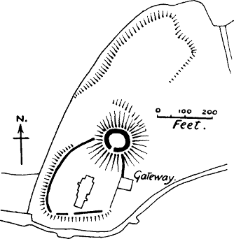
Trematon, Cornwall.
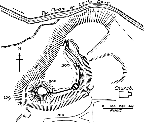
Tutbury, Staffs.
Fig. 34.
Tutbury, Staffordshire (Fig. 34).—In the magnificent earthworks of this castle, and the strength of its site, we probably see a testimony to the ability of Hugh d’Avranches; for we learn from Ordericus that in 1070 William I. gave to Henry de Ferrers the castle of Tutbury, which had belonged to Hugh d’Avranches,[728] to whom the king then gave the more dangerous but more honourable post of the earldom of Chester. Domesday Book simply states that Henry de Ferrers has the castle of Tutbury, and that there are forty-two men living by their merchandise alone in the borough round the castle.[729]
At Tutbury the keep was placed on an artificial motte, which itself stood on a hill of natural rock, defended on the N.W. side by precipices. There is no trace of any ditch between the motte and bailey. At present there is only the ruin of a comparatively modern tower on the motte, but Shaw states that there was formerly a stone keep.[730] A description of Elizabeth’s reign says, “The castle is situated upon a round hill, and is circumvironed with a strong wall of astilar [ashlar] stone.... The king’s lodging therein is fair and strong, bounded and knit to the wall. And a fair stage hall of timber, of a great length. Four chambers of timber, and other houses well upholden, within the walls of the castle.”[731] The king’s lodging will no doubt be the closed gatehouse; the custom of erecting gatehouse palaces arose as early as the 13th century. This account shows how many of the castle buildings were still of timber in Elizabeth’s reign.
The bailey is quadrant-shaped, and has the motte at its apex. Its area is 2½ acres. Its most remarkable feature is that it still retains its ancient banks on the east side and part of the south, and the more recent curtain is carried on top of them. This curtain is of the same masonry as the three remaining towers, which are of excellent Perpendicular work, and are generally attributed to John of Gaunt, who held this castle after his marriage with Blanche of Lancaster. The first castle was undoubtedly of wood; it was pulled down by order of Henry I. in 1175,[732] nor does there seem to have been any resurrection till the time of Earl Thomas of Lancaster at the earliest.
Though Tutbury was the centre of the Honour of Ferrers, it does not seem to have been even a manor in Saxon times. The borough was probably the creation of the castellan, who also founded the Priory.[733] There is no statement in the Survey from which we can learn the value T. R. E., but T. R. W. it was 4l. 10s.
Tynemouth, Northumberland.—Besieged and taken by William Rufus in 1095.[734] There is no motte there, and probably never was one, as the situation is defended by precipitous cliffs on all sides but one, where a deep ditch has been cut across the neck of the headland.
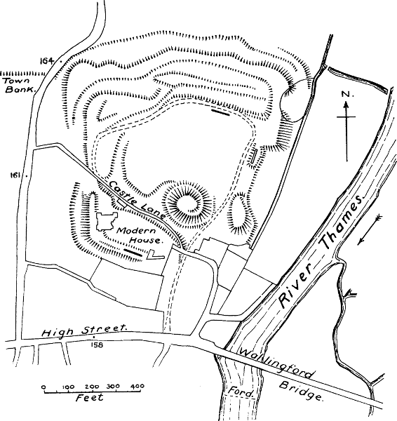
Wallingford, Berks.
Fig. 35.
Wallingford, Berkshire (Fig. 35).—There is good reason to suppose that in the vallum of the town of Wallingford we have an interesting relic of Saxon times. Wallingford is one of the boroughs enumerated in the Burghal Hidage; it was undoubtedly a fortified town at the time of the Conquest,[735] and is called a burgus in Domesday Book; but there appears to be no evidence to connect it with Roman times except the discovery of a number of Roman coins in the town and its neighbourhood. No Roman buildings or pavements have ever been found.[736] The Saxon borough was built on the model of a Roman chester: a square with rounded corners. The rampart of Wallingford, which still exists in great part, is entirely of earth, and must have been crowned with a wooden wall, such as was still existing at Portsmouth in Leland’s time.[737] The accounts of Wallingford in the great Survey are very full and important. “King Edward had eight virgates in the borough of Wallingford, and in these there were 276 haughs paying 11l. of rent. Eight have been destroyed for the castle.”[738] This Norman castle was placed in the N.E. corner of the borough. At present its precincts cover 30 acres,[739] but this includes garden grounds, and no doubt represents later enclosures. No ancient plan of the castle has been preserved, but from Leland’s description there appear to have been three wards in his time, each defended by banks and ditches. The inner ward, which was doubtless the original one, is rudely oblong in shape; it covers 4½ acres. Leland says, “All the goodly buildings, with the towers and dungeon, be within the third dyke.” The motte, which still exists, was on the south-eastern edge of this ward; that is, it was so placed as to overlook both the borough and the ford over the Thames.[740] It was ditched around, and is said to have had a stone keep on the top; but no foundations were found when it was recently excavated. It was found to rest on a foundation of solid masonry several feet thick, sloping upwards towards the outside, so that it must have stood in a kind of stone saucer.[741] The masonry which remains in the other parts of the castle is evidently none of it of the early Norman period, unless we accept a fragment of wall which contains courses of tiles. Numerous buildings were added in Henry III.’s reign; the walls and battlements were repaired, and the hurdicium, which had been blown down by a high wind, was renewed.[742] But the motte and the high banks show clearly that the first Norman castle was of wood.
The value of the royal borough of Wallingford had considerably risen since the Conquest.[743]
Warwick (Fig. 36).—Here again we have a castle built on land which the Conqueror obtained from a Saxon convent, a positive proof that there was no castle there previously. Only a small number of houses was destroyed for the castle,[744] and this points to the probability, which is supported by some other evidence, that the castle was built outside the town. Warwick, of course, was one of the boroughs fortified by Ethelfleda, and it was doubtless erected to protect the Roman road from Bath to Lincoln, the Foss Way, against the Danes. Domesday Book, after mentioning that the king’s barons have 112 houses in the borough, and the abbot of Coventry 36, goes on to say that these houses belong to the lands which the barons hold outside the city, and are rated there.[745] This is one of the passages from which Professor Maitland has concluded that the boroughs planted by Ethelfleda and her brother were organised on a system of military defence, whereby the magnates in the country were bound to keep houses in the towns.[746] Ordericus, after the well-known passage in which he states that the lack of castles in England was one great cause of its easy conquest by the Normans, says: “The king therefore founded a castle at Warwick, and gave it in custody to Henry, son of Roger de Beaumont.”[747] Putting these various facts together, we may fairly assert that the motte which still forms part of the castle of Warwick was the work of the Conqueror, and not, as Mr Freeman believed, “a monument of the wisdom and energy of the mighty daughter of Alfred,”[748] whose energy was very much better employed in the protection of her people. Dugdale, who also put the motte down to Ethelfleda, was only copying Rous, a very imaginative writer of the 15th century.
The motte of Warwick is mentioned several times in the Pipe Rolls of Henry II.; it then carried wooden structures on its top.[749] In Leland’s time there were still standing on this motte the ruins of a keep, which he calls by its Norman name of the Dungeon. A fragment of a polygonal shell wall still remains.[750] But there is not a scrap of masonry of Norman date about the castle. The motte, and the earthen bank which still runs along one side of the court, show that the first castle was a wooden one. The bailey is oblong in shape, the motte being outside it; its area is about 2½ acres.
The value of Warwick had doubled since the Conquest.
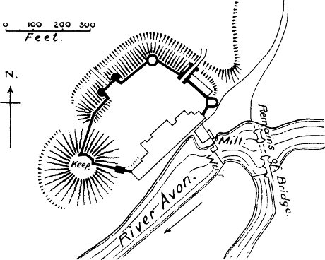
Warwick.
Wigmore, Hereford.
Fig. 36.
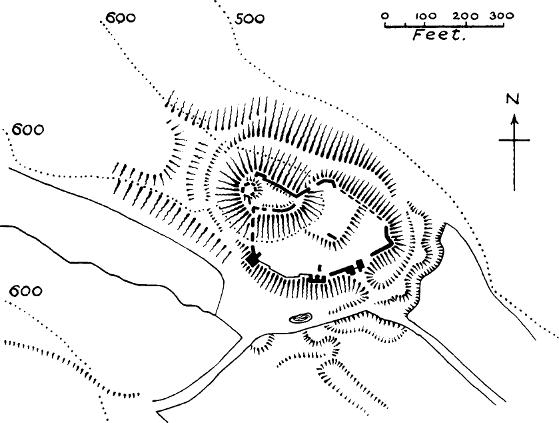
Wigmore, Herefordshire (Fig. 36).—We have already referred to the absurdity of identifying this place with the Wigingamere of the Anglo-Saxon Chronicle.[751] We have the strongest indication that the Norman castle at Wigmore was a new erection, since Domesday Book tells us that William FitzOsbern built it on waste land called Mereston.[752] This express statement disposes of the fable in the Fundationis Historia of Wigmore Priory, that the castle of Wigmore had belonged to Edric the Wild, and was rebuilt by Ralph Mortimer.[753] Wigmore had only been a small manor of two taxable hides in Saxon times. Whereas it had then been unproductive, at the date of the Survey there were two ploughs in the demesne, and the borough attached to the castle yielded 7l. Here we have another instance of the planting of a borough close to a castle, and of the revenue which was thus obtained.
There is a very large and high motte at Wigmore Castle, of oval shape, on a headland which has been cut off by a deep ditch. The earthen banks of its first fortification still remain, enclosing a small ward, but on top of them is a wall in masonry, and the ruins of a polygonal keep;[754] also the remains of two mural towers. Half-way down the end of the headland, below the motte, is a small square court, which may have been the original bailey; below it, again, is a larger half-moon bailey furnished with walls and towers. But the whole area covered is only 1 acre. The masonry is none of it earlier than the Decorated period, except one tower in the bailey wall which may be late Norman.
Winchester. (From a plan by W. Godson, 1750.)
Fig. 37.
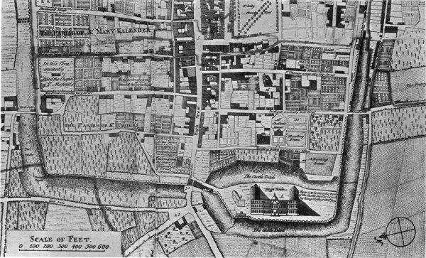
Winchester, Hants.—We include Winchester among the castles mentioned or alluded to in Domesday Book, because we think it can be proved that the domus regis mentioned under Alton and Clere is the castle built by William outside the west gate of the city, where the present County Hall is now almost the only remaining relic of any castle at all.[755] Under the head of “Aulton” we are told that the abbot of Hyde had unjustly gotten the manor in exchange for the king’s house, because by the testimony of the jurors it was already the king’s house.[756] That excambio domus regis should read excambio terræ domus regis is clear from the corresponding entry under Clere, where the words are pro excambio terræ in qua domus regis est in civitate.[757] The matter is put beyond a doubt by the confirmatory charter of Henry I. to Hyde Abbey, where the king states that his father gave Aulton and Clere to Hyde Abbey in exchange for the land on which he built his hall in the city of Winchester.[758] Where, then, was this hall, which was clearly new, since fresh land was obtained for it, and which must not therefore be sought on the site of the palace of the Saxon kings? The Liber Winton, a roll of Henry I.’s time, says that twelve burgesses’ houses had been destroyed and the land was now occupied by the king’s house.[759] Another passage says that a whole street outside the west gate was destroyed when the king made his ditch.[760] These passages justify the conclusion of Mr Smirke that the king’s house at Winchester was neither more nor less than the castle which existed until the 17th century outside the west gate.[761] Probably the reason why it is spoken of so frequently in the earliest documents as the king’s house or hall, instead of the castle, is that in this important city, the ancient capital of Wessex, where the king “wore his crown” once a year, William built, besides the usual wooden keep on the motte, a stone hall in the bailey, of size and dignity corresponding to the new royalty.[762] In fact, the hall so magnificently transformed by Henry III., and known to be the old hall of the castle, can be seen on careful examination to have still its original Norman walls and other traces of early Norman work.[763] The palace of the Saxon kings stood, where we might expect to find the palace of native princes, in the middle of the city; according to Milner it was on the site of the present Square.[764] William may have repaired this palace, but that he constructed two royal houses, a palace and a castle, is highly improbable. The castle became the residence of the Norman kings, and the Saxon palace appears to have been neglected.[765] We see with what caution the Conqueror placed his castle at the royal city of Wessex without the walls. Milner tells us that there was no access to it from the city without passing through the west gate.[766] The motte of the castle appears to have been standing in his time, as he speaks of “the artificial mount on which the keep stands.”[767] It is frequently mentioned in mediæval documents as the beumont or beau mont. It was surrounded by its own ditch.[768] The bailey, if Speed’s map is correct, was triangular in shape. With its ditches and banks the castle covered 6 acres, according to the commissioners who reported on it in Elizabeth’s reign; but the inner area cannot have been more than 4½ acres. We may infer from the sums spent on this castle by Henry II., that he was the first to give it walls and towers of stone; the Pipe Rolls show entries to the amount of 1150l. during the course of his reign; the work of the walls is frequently specified, and stone is mentioned.
Domesday Book does not inform us whether the value of Winchester had risen or fallen since the Conquest.
(From Ashmole’s “Order of the Garter.”)
Fig. 38.
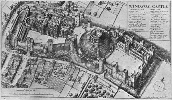
Windsor (Fig. 38).—Here we have another of the interesting cases in which the geld due from the tenant of a manor is lessened on account of a castle having occupied a portion of the land.[769] The Survey tells us that the castle of Windsor sits in half a hide belonging to the manor of Clewer, which had become William’s property as part of the spoils of Harold. It was now held of the king by a Norman tenant-in-chief, but whereas it was formerly rated as five hides it was now (that is, probably, since the castle was built) rated as four and a half hides. Of course we are not to suppose that the castle occupied the whole half hide, which might be some 60 acres; but it extinguished the liability of that portion. At Windsor, however, we have no occasion to press this argument as a proof that the castle was new, since it is well established that the palace of the Saxon kings was at least 2 miles from the present castle and town, in the village long known as Old Windsor, which fell into decay as the town of Windsor sprang up under the Norman castle.[770] The manor of Windsor was given by Edward the Confessor to the convent of Westminster, but recovered by the Conqueror.[771] But as the Survey shows us, he did not build his castle in the manor of Windsor, but in that of Clewer. He built it for a hunting-seat,[772] and it may have been for the purpose of recovering forest rights that he resumed possession of Old Windsor; but he placed his castle in the situation which he thought best for defence. For even a hunting-seat in Norman times was virtually a castle, as many other instances show.
It is needless to state that there is no masonry at Windsor of the time of the Conqueror, or even of the time of his son Henry I., in spite of the statement of Stowe that Henry “new builded the castle of Windsor.” This statement may perhaps be founded on a passage in the Anglo-Saxon Chronicle which says that Henry held his court for the first time in the New Windsor in 1110. Perhaps the Chronicle here refers to the borough of New Windsor, as an entry in the Pipe Roll of Henry I. seems to show that he was the first to enclose the burgus of Windsor.[773] For it is probable that the first stone castle at Windsor was built by Henry II., who spent £1670 on it in the course of his reign. One of his first acts after his accession was an exchange of land at Windsor, which seems to have been for the purpose of a vineyard, and was possibly the origin of the second bailey.[774] At present the position of the motte is central to the rest of the castle, but this is so unusual that it suggests the idea that the upper ward is the oldest, and that the motte stood on its outer edge. Henry II. surrounded the castle with a wall, at a cost of about 128l.[775] The other entries in the Pipe Rolls probably refer to the first stone shell on the motte, and there is little doubt that the present Round Tower, though its height has been raised in modern times, and its masonry re-dressed and re-pointed so as to destroy all appearance of antiquity, is in the main of Henry II.’s building. The frequent payments for stone show the nature of Henry’s work.
Although so much masonry was put up in Henry II.’s reign, the greater part of what is now visible is not older than the time of Henry III. The lower bailey seems to have been enlarged in his reign, as the castle ditch was extended towards the town, and compensation given for houses taken down.[776] The upper (probably the original) ward is rectangular in shape, and with the motte and its ditches covers about 6½ acres.[777] The state apartments, a chapel, and the Hall of St George, are in the upper ward, showing that this was the site of the original hall and chapel of the castle. The charter of agreement between Stephen and Henry in 1153 speaks of the motte of Windsor as equivalent to the castle.[778] Repairs of the motte are mentioned in the Pipe Rolls of Henry II.[779]
The value of the manor of Clewer had fallen since the Conquest; that of Windsor, which was worth 15l. T. R. E., but after the Conquest fell to 7l., was again worth 15l. at the date of the Survey.[780]
Wisbeach, Cambridgeshire.—William I. built a castle here in 1072, after suppressing the revolt of Hereward, in order to hold in check the Cambridgeshire fen country.[781] There is an early mention of it in the Register of Thorney Abbey. This castle, after being several times rebuilt, is now completely destroyed, and “several rows of elegant houses built on the site.” Nevertheless, there still remain distinct traces of the motte-and-bailey pattern in the gardens which now occupy the site of the original castle of King William; the present Crescent probably follows the line of the ditch. The meagre indications preserved in casual accounts confirm this. There was an inner castle of about 2 acres, just the area of the present garden enclosure, and an outer court, probably an addition, of some 4 acres.[782] Both areas were moated. Weston, a prisoner who was confined in the keep of this castle in the 17th century, has left an account of his captivity, in which he casually mentions that the keep or dungeon stood upon a high terrace, from which he could overlook the outer bailey, and was surrounded by a moat filled with water.[783]
The castle is not mentioned in Domesday, but as might be expected in a district which had been so ravaged by war, the value of the manor had fallen.
Worcester.—This borough, as we have seen, was fortified by Ethelfleda and her husband Ethelred in the 9th century. That the fortifications thus erected were those of a city and not of a castle is shown with sufficient clearness by the remarkable charter of this remarkable pair, in which they declare that they have built the burh at Worcester to shelter all the people, and the churches, and the bishop.[784] The castle is first mentioned in the Anglo-Saxon Chronicle in 1088, and it is to be noted that it is styled the king’s castle. Urse d’Abitot, the Norman sheriff of Worcester, has the credit of having built the first castle, and Malmesbury relates that he seized part of the monks’ cemetery for the bailey.[785] The monks, however, held on to their right, and in the first year of Henry III. the bailey was restored to them by the guardians of the young king, the motte being reserved for the king’s use.[786] The first wooden castle was burnt in 1113.[787] The tower or keep which succeeded it, and which was repaired by Henry II.,[788] may have been either of stone or wood; but in the order of John, that the gateway of the castle, which is of wood, is to be made of stone, we get a hint of the gradual transformation of the castle from a wooden to a stone fortress.[789]
Worcester Castle was outside the town, from Speed’s map, and was near the Severn. The area now called College Green was no doubt the outer ward of the castle, which was restored to the convent by Henry III. The tower called Edgar’s Tower was built by the monks as the gatehouse to their newly conceded close.[790] From the map given by Green, this outer bailey appears to have been roughly square; but there was also a small oblong inner ward, retained by the king, where the gaol was afterwards built. The area of the castle is said to have been between 3 and 4 acres.[791] The motte, which is mentioned several times in mediæval documents,[792] was completely levelled in 1848; it was then found out that it had been thrown up over some previous buildings, which were believed to be Roman, though this seems doubtful.[793]
The value of Worcester had risen since the Conquest.[794]
York (Fig. 39).—William the Conqueror built two castles at York, and the mottes of both these castles remain, one underneath Clifford’s Tower, the keep of York Castle, the other, on the south side of the Ouse, still bearing the name of the Baile Hill, or the Old Baile.[795] The Anglo-Saxon Chronicle implies, though it does not directly state, that both these castles were built in 1068, on the occasion of William’s first visit to York. The more detailed narrative of Ordericus shows that one was built in 1068, and the other at the beginning of 1069, on William’s second visit.[796] Both were destroyed in September 1069, when the English and Danes captured York, and both were rebuilt before Christmas of the same year, when William held his triumphant Christmas feast at York.
This speedy erection, destruction, and re-erection is enough to prove that the castles of William in York were, like most other Norman castles, hills of earth with buildings and stockades of wood, especially as we find these hills of earth still remaining on the known sites of the castles. And we may be quite sure that the Norman masonry, which Mr Freeman pictures as so eagerly destroyed by the English, never existed.[797] But the obstinate tendency of the human mind to make things out older than they are has led to these earthen hills being assigned to Britons, Romans, Saxons, Danes, anybody rather than Normans. A single passage of William of Malmesbury, in which he refers to the castrum which the Danes had built at York in the reign of Athelstan, is the sole vestige of basis for the theory that the motte of Clifford’s Tower is of Danish origin.[798] The other theories have absolutely no foundation but conjecture. If Malmesbury was quoting from some older source which is now lost, it is extremely probable that the word castrum which he copied, did not mean a castle in our sense of the word at all, but was a translation of the word burh, which almost certainly referred to a vallum or wall constructed round the Danish suburb outside the walls of York. Such a suburb there was, for there in 1055 stood the Danish church of St Olave, in which Earl Siward was buried, and the suburb was long known as the Earlsburgh or Earl’s Burh, probably because it contained the residence of the Danish earls of Northumbria.[799] This suburb was not anywhere near Clifford’s Tower, but in quite a different part of the city. To prove that both the mottes were on entirely new sites, we have the assurance of Domesday Book that out of the seven shires or wards into which the city was divided, one was laid waste for the castles; so that there was clearly a great destruction of houses to make room for the new castles.[800]
York Castle and Baile Hill. (From a plan by P. Chassereau, 1750.)
Fig. 39.
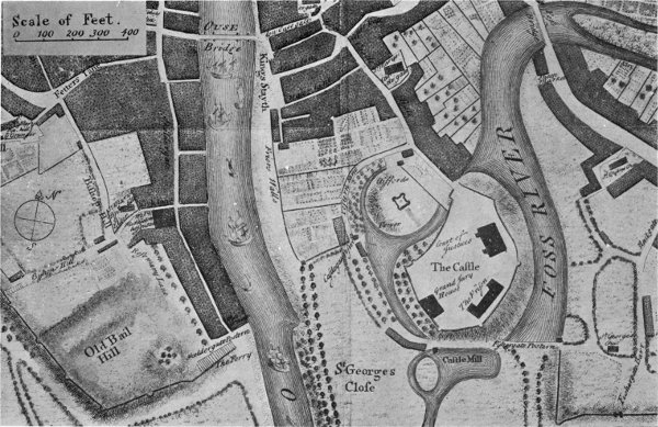
What has been assumed above receives striking confirmation from excavations made recently (1903) in the motte of Clifford’s Tower. At the depth of 13 feet were found remains of a wooden structure, surmounted by a quantity of charred wood.[801] Now the accounts of the destruction of the castles in 1069 do not tell us that they were burned, but thrown down and broken to pieces.[802] But the keep which was restored by William, and on the repair of which Henry II. spent 15l. in 1172,[803] was burnt down in the frightful massacre of the Jews at York Castle in 1190.[804] The excavations disclosed the interesting fact that this castle stood on a lower motte than the present one, and that when the burnt keep was replaced by a new one the motte was raised to its present height, “an outer crust of firmer and more clayey material being made round the older summit, and a lighter material placed inside this crater to bring it up to the necessary level.” This restoration must have taken place in the third year of Richard I., when 28l. was spent “on the work of the castle.”[805] This small sum shows that the new keep also was of wood; and remains of timber work were in fact found on the top of the motte during the excavations, though unfortunately they were not sufficiently followed up to determine whether they belonged to a wooden tower or to a platform intended to consolidate the motte.[806] It is extremely likely that this third keep was blown down by the high wind of 1228, when 2s. was paid “for collecting the timber of York Castle blown down by the wind.”[807] In its place arose the present keep, one of the most remarkable achievements of the reign of Henry III.[808] The old ground-plan of the square Norman keep was now abandoned, and replaced by a quatrefoil. The work occupied thirteen years, from the 30th to the 43rd Henry III., and the total sum expended was 1927l. 8s. 7d., equal to about 40,000l. of our money. This remarkable fact has slumbered in the unpublished Pipe Rolls for 700 years, never having been unearthed by any of the numerous historians of York.
The keep was probably the first work in stone at York Castle, and for a long time it was probably the only defensive masonry. The banks certainly had only a wooden stockade in the early part of Henry III.’s reign, as timber from the forest of Galtres was ordered for the repair of breaches in the palicium in 1225.[809] As late as Edward II.’s reign there was a pelum, or stockade, round the keep, on top of a murus, which was undoubtedly an earthen bank.[810] At present the keep occupies the whole top of the motte except a small chemin de ronde, but the fact so frequently alluded to in the writs, that a stockade ran round the keep, proves that a small courtyard existed there formerly, as was usually the case with important keeps. Another writ of Edward II.’s reign shows that the motte was liable to injury from the floods of the River Fosse,[811] and probably its size has thus been reduced.
The present bailey of York Castle does not follow the lines of the original one, but is an enlargement made in 1825. A plan made in 1750, and reproduced here, shows that the motte was surrounded by its own ditch, which is now filled up, and that the bailey, around which a branch of the Fosse was carried, was of the very common bean-shaped form; it was about 3 acres in extent. The motte and bailey were both considerably outside what is believed to have been the Anglo-Saxon rampart of York,[812] but the motte was so placed as to overlook the city.
The value of the city of York, in spite of the sieges and sacks which it had undergone, and in spite of there being 540 houses “so empty that they pay nothing at all,” had risen at the date of the Survey from 53l. in King Edward’s time to 100l. in King William’s.[813] This extraordinary rise in value can only be attributed to increased trade and increased exactions, the former being promoted by the greater security given to the roads by the castles, the latter due to the tolls on the high-roads and waterways, which belonged to the king, and the various “customs” belonging to the castles, which, though new, were henceforth equally part of his rights.
The Baile Hill, York (Fig. 39).—There can be no doubt whatever that this still existing motte was the site of one of William’s castles at York, and it is even probable that it was the older of the two, as Mr Cooper conjectures from its position on the south side of the river.[814] The castle bore the name of the Old Baile at least as early as the 14th century, perhaps even in the 12th.[815] In 1326 a dispute arose between the citizens of York and Archbishop William de Melton as to which of them ought to repair the wall around the Old Baile. The mayor alleged that the district was under the express jurisdiction of the archbishop, exempt from that of the city; the archbishop pleaded that it stood within the ditches of the city.[816] The meaning of this dispute can only be understood in the light of facts which have recently been unearthed by the industry and observation of Mr T. P. Cooper, of York.[817] The Old Baile, like so many of William’s castles, originally stood outside the ramparts of the city. The original Roman walls of York (it is believed) enclosed only a small space on the eastern shore of the Ouse, and before the Norman Conquest the city had far outgrown these bounds, and therefore had been enlarged in Anglo-Saxon times. It appears that the Micklegate suburb was then for the first time enclosed with a wall, and as this district is spoken of in Domesday Book as “the shire of the archbishop,” it was evidently under his jurisdiction. At a later period this wall was buried in an earthen bank, which probably carried a palisade on top, until the palisade was replaced by stone walls in the reign of Henry III.[818]
The evidence of the actual remains renders it more than probable that this rampart turned towards the river at a point 500 feet short of its present angle, so that the Old Baile, when first built, was quite outside the city walls.[819] This is exactly how we should expect to find a castle of William the Norman’s in relation to one of the most turbulent cities of the realm; and, as we have seen, the other castle at York was similarly placed. By the time of Archbishop Melton the south-western suburb was already enclosed in the new stone walls built in the 13th century, and these walls had been carried along the west and south banks of the Old Baile, so as to enclose that castle within the city. This was the archbishop’s pretext for trying to lay upon the citizens the duty of maintaining the Old Baile. But probably on account of his ancient authority in this part of the city, the cause went against him; though he stipulated that whatever he did in the way of fortification was of his own option, and was not to be accounted a precedent. A contemporary chronicler says that he enclosed the Old Baile first with stout planks 18 feet long, afterwards with a stone wall:[820] an interesting proof that wooden fortifications were still used in the reign of Edward III.
Though the base court of the Old Baile is now built over, its area and ditches were visible in Leland’s time,[821] and can still be guessed at by the indications Mr Cooper has noted. The area of the bailey must have been nearly 3 acres, and its shape nearly square. This measurement includes the motte, which was placed in the south-west corner on the line of the banks; it thus overlooked the river as well as the city.[822]