Volume 2 — SCARBOROUGH CASTLE.
Reading edition
ON the north-eastern shore of England, where the cliffs of Yorkshire rear a bold though broken front towards the German Ocean, there is seen, midway between the Tees and the Humber, or, more nearly, between Whitby and Flamborough Head, a tall and rugged and almost isolated headland of rock, which, from times beyond the records of history, has borne the appropriate name of Scarborough. The scaur or rugged cliff, the tall summit of which forms the natural burgh or strong place, rises precipitately about 300 feet from the sea beach, and has on its northern side the small bay of which Scalby-ness forms the opposite horn, and to its south the deeper and more spacious inlet, on the strand of which, under the protection of the scaur, is nestled the ancient seaport town of Scarborough.
At no period when life and limb were valued and endangered could the advantages of Scarborough as a place of dwelling or of refuge have been overlooked. What art has executed at Flamborough, Nature, with a bolder hand, has here provided. The bay gave facilities for fishing or for pursuits connected with the sea, and the half-isolated cliff afforded security from attack from any quarter. And yet there is no evidence that Scarborough was regularly inhabited by either the original Brigantes or their Roman invaders. The adjacent wolds are scarred with traces of early contests, but are of too cold and too barren a character to have supported any considerable population, or indeed any population save a few shepherds. The vale of the Derwent, now rich and fertile, was, in Roman times, a chain of impassable swamps and morasses, flanked with dense and equally impenetrable forests. Neither Holderness nor the south of Cleveland contain many Roman remains, nor does there appear to have been any regular settlement by that people between Delgovitia and Derventio (Millington and Stamford Bridge or New Malton) and the eastern coast.
The tract between the Humber and the Whitby Esk was invaded in the sixth century by a tribe of the Engles, who from invaders became settlers, and, as was the manner of the Teutonic tribes, finally consolidated themselves into a kingdom, the nucleus of the well-known Deira. That they inhabited the coasts of Holderness and Cleveland, the edges and valleys of the Wolds and of Pickering and the adjacent plain of York, is a matter of history, and is shown by the names of their settlements and the existing peculiarities of the speech of the people, their descendants, and by the very marked Burh of Skipsea, which has survived all its subsequent additions; but the rock of Scarborough, though as strong and almost as grand a natural feature as Bamborough, is not on record as a Deiran fortress, still less as a regal seat, nor does it exhibit, nor indeed did it need, any of those remarkable and well-defined earthworks which indicate the later Saxon residences. Its first appearance in history, though late, is creditable. When, early in 1066, Harold Hardrada and his traitor ally Tostig wasted and pillaged the earldom of Morkere, the men of Scarborough met the invaders in arms, and made a brave, though fruitless, resistance.
Scarborough is not named in Domesday, though the soke of Walesgriff, or Falsgrave, of which it seems to have formed a part, is therein recorded, and then belonged to William de Perci, the lord of eighty-six Yorkshire lordships, and the ancestor of that Agnes whose Louvaine descendants assumed her family name. Percy, however, did not long retain this manor, for Eudo of Champagne, kinsman, and by marriage nephew to the conqueror, on the departure of Drogo le Brevere, the reputed founder of the Norman works at Skipsea Castle, received from William the land of Holderness, and with it, probably, the adjacent manor of Falsgrave. Their son, Stephen, besides his paternal heritage of Holderness, held maternally the Norman territory of Aumarle, or Albemarle, from whence his mother Adeliza was styled “Comitissa de Albamarla,” and Stephen, who died in 1127, bore the same title.
His son, William, the second earl, lord of Holderness and founder of the Abbey of Meaux, took a very active part in English affairs, and was in his time the most powerful baron in the north. He commanded at the battle of the Standard in 1138, and received from King Stephen what Dugdale calls the earldom of Yorkshire. He died in 1179, having been a liberal benefactor to many Yorkshire religious houses, and according to William of Newburgh, who wrote in about 1190, the builder of Scarborough Castle. If this be so, it must have been when William came into the earldom, that is, soon after 1127, for on the accession of Henry II., in 1154, Scarborough was one of the castles selected for demolition, and upon the earl’s resistance, Henry himself, after a severe struggle, took possession of it, and, becoming acquainted with the value of its position, instead of destroying, attached it to the Crown. Taking all this into consideration, and having regard to the material evidence afforded by the remains of the keep and the older parts of the curtain, the most probable conclusion is that Earl William’s fortress was of a temporary character, and the keep (arx magna et præclara) and the older parts of the existing masonry are the work of King Henry at a later period.
In the Pipe-roll of 4 Henry II. the sheriff of Yorkshire is allowed £4 for works on the castle of Scardeburc, and subsequently Henry granted or confirmed a charter of incorporation to the town, for the farm of which, 30 Henry II., an account was rendered by the sheriff. The town continued to thrive, and from time to time contributed to the “dona ad auxilium,” to talliage and scutage. King John paid four visits to the castle in 1201, 1210, 1213, and 1216, remaining there altogether about nine days. In 1202 and 1204 John de Builly was the constable, and then and in 1213 military prisoners were kept there. In 1208 Builly was superseded by Robert de Vaux, and he again in 1215 by Geoffrey de Neville, the King’s Chamberlain, at which time sixty “servientes” and ten “balistarii” seem to have constituted the garrison. That John kept the castle in repair appears from frequent allowances for works. Wine also was sent there from Portsmouth, and lead for covering a tower. Payments occur for “servientes,” “balistarii” and others employed in the castle. During John’s reign it appears that at one time William de Duston was in charge, and had orders to receive William, Earl of Albemarle, and his companions into the castle. This was William de Fortibus, a Magna Charta baron, and Earl of Albemarle, in right of his mother, Hawise, the daughter and heiress of Earl William le Gros. Probably he took advantage of John’s difficulties to revive a claim to the castle, which, however, he does not seem to have been able to enforce. In 1215 Neville was again in office, and had an order for 100 marcs, “ad opus—ad castrum nostrum de Scardeburg’ muniendum.” John de Neville, son of Geoffrey, took charge of the castle under Henry III. in 1225, and the fortress seems to have been kept in repair all through that reign. In 1252 Henry granted to the town a permission for the construction of a new pier.
The strong, and, on the whole, just government of Edward I. led to the neglect of such of the castles of the kingdom as were not necessary for the defence of a menaced frontier, and among them of Scarborough, but under his son they became again of importance, and Scarborough reappears in the public records. Edward II. was here in 1312, and left the castle in charge of Gaveston while he proceeded to York. It was attacked and taken by the Earl of Pembroke, not by assault, but by starvation. In 1318 the town was burned by the Scots, but they do not appear to have been able to take the castle. Sixty years later the town was threatened by sea by a Scottish adventurer, who, however, failed to take it, and was subsequently made prisoner. For the next three centuries Scarborough Castle was left to fall into decay, or only so far repaired as to be employed occasionally as a prison. In 1536, the year of the Pilgrimage of Grace, Aske, who was a native of Aughton on the Derwent, led his ill-disciplined followers against it, but without success. A little later, in 1553, during Wyatt’s rebellion, it was taken, probably by surprise, by the Earl of Stafford, but held for three days only.
In the contest between Charles and the Parliament in the seventeenth century, Scarborough, with many other Yorkshire castles, more or less ruinous, was held for the king, and in July, 1645, the Parliamentary forces laid siege to it in form. A battery was posted upon the roof of the chancel of the ancient parish church, about 170 yards from the outer gate of the castle, and a second to the north of it, upon the edge of the cliff in front of the barbican. The castle was taken and held for a short time, and in 1648, being again held for the king, it was a second time attacked and taken, and shortly afterwards a mine was sprung in the ground floor of the keep, laying open its eastern side. Probably the forebuilding covering the entrance to the keep was destroyed at the same time.
The town of Scarborough was walled from an early period. Leland speaks of banks and ditches, and fragments of the walls, and mentions its two gates, Newburgh and Aldburgh, or Anborough, one of which remains. The town ditch extended from the castle barbican along the high ground southwards, and upon it, 550 yards from the barbican, was the Anborough gate. The town contained three friaries and one parish church, dedicated to the Virgin, and belonging to the Cistertians. It is a large building near the castle, of which the chancel, or lady chapel, has remained in ruins ever since the first Parliamentary siege. The platform occupied by the castle is extra parochial, usually an ecclesiastical, not a military privilege.
THE CASTLE.
The platform, to which the keep forms the key of the approach, is in plan a rhomboid, in length from north to south 600 yards, and from east to west 300 yards, covering about 19 acres, and its table summit ranges from 300 feet to 336 feet above the sea level. The two eastern or seaward faces, measuring together about 700 yards in length, rise abruptly from the sea beach, and are absolutely impregnable. The north-western face, 300 yards in length, and looking towards the north bay and sands, is lower, but still precipitous. The south-western face, also 300 yards in length, looks towards the town. Though not precipitous it is very steep, and at its base a broad ravine, known as the castle moat, intervenes between the castle and the town. A chapel and a burial-ground formerly occupied the seaward salient of the cliff, and behind these was Our Lady’s Well, the spring supplying which was reputed inexhaustible. The lowest and the only weak point in the platform was the landward or western angle, and here was posted the keep, from which northwards and southwards along the crest of the contiguous faces a curtain-wall was extended. Northwards, this wall was in length about 70 yards, ceasing as the cliff rose in height, and rendering artificial defence unnecessary. Southwards, the wall, from 20 feet to 25 feet in height, was carried all along the south-western front, and was strengthened, either originally or at an early period, by ten or twelve half-round turrets of various sizes. The six smaller were solid, like those of Coningsborough and Knaresborough; the larger, from 25 feet to 30 feet diameter, were hollow. These towers were parts of circles in plan, and have been much mutilated. They were probably cut down and filled with earth during the siege of 1640, when a swivel-gun seems to have been mounted en barbette on each. At present they are open at the gorge, and no higher than the contiguous curtain. Three loops may still be traced at their basement level, and two or three others at what must have been the first floor. Outside the wall are a number of buttresses of various sizes, shapes, and dates, some of which seem original, and of the late Norman period. The largest of these bastion towers is known as “The Queen’s Tower.” Near the centre of this front, upon the curtain, was a building about 110 feet by 40 feet, called “Mossdale,” or “The King’s Hall.” No doubt here stood the hall, kitchen, and other offices for the accommodation of the garrison. The present building is a modern barrack, built with the usual disregard of taste that has long characterised such buildings.
Where the curtain of the south-eastern front terminates on the sea cliff there seems anciently to have been a tower, known as “Cockbill.” More recently a small battery has been constructed outside the wall, and upon the crest of the slope, raking the ditch, and commanding a part of the harbour. Probably this battery was thrown up in preparation for the Parliamentary siege, for the remains of the tower above it are known as “Charles’s Tower.” Although the southern curtain has been much mutilated and restored, and towers, bastions and buttresses incorporated with its substance, the greater part of it is old, and probably original.
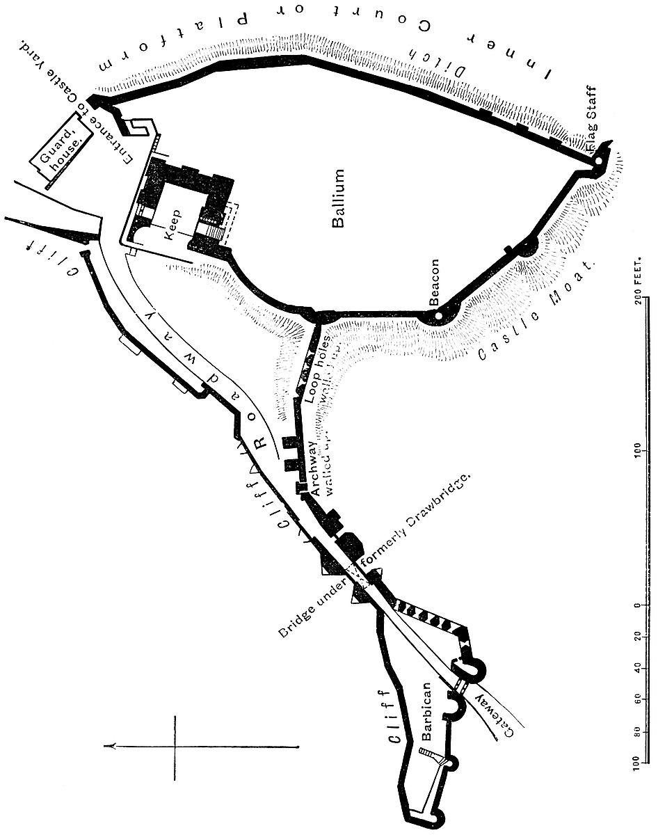
PLAN OF SCARBOROUGH CASTLE.
For the protection of the keep, quite as much from the mercenaries who, in the twelfth century, often formed the garrison, as from the exterior foe, an oblong space 112 yards north and south by 573 yards east and west, was walled in as a base court or bailey. It is taken out of the platform, and includes the keep. Its outer or western wall is the outer wall of the place, its opposite or eastern wall shuts out the keep from the main platform, and at the exterior foot of this wall, and within the platform, is a deep ditch. If the keep be regarded as the centre of the fortress, this enclosure is the inner ward, but as regards the position of the main entrance the platform deserves that name. It will, on the whole, be convenient to reserve the name of platform for the large area, and refer to the other as the bailey. Probably the bailey originally contained the Lords’ Hall, or kitchen, chapel, and lodgings. All traces of these have, however, disappeared above the surface. The position of the well is marked by a depression in the sward. The entrance to the castle occupied a hollow way below, and to the west and north of the keep traversed the bailey close below the keep, and entered the platform at the point now occupied by the modern guard-room. The approach to the castle must always have been settled by the peculiar character of the ground. There is, in fact, but one practicable line, that along the ridge between the edge of the cliff overlooking the north bay and the head of the ditch between the castle and the town. This ridge has been fortified on one side, where the cliff is about 240 feet high, by a light parapet wall, and on the other by a much stronger wall, which branches off from the curtain of the bailey, and commands the head of the ditch. Where they commence the two walls are about 50 yards apart, but they rapidly converge, and at 70 yards from the keep are but 12 feet apart, and thus continue, forming a raised causeway, along which the approach is carried. This causeway traverses the depression of the ground at the head of the castle moat by a sort of viaduct, which at its deepest point is about 25 feet high, and is in length, from its entrance in front of the keep to its termination in the barbican, about 70 yards. It is of masonry with lateral parapets, and a roadway 10 feet 6 inches broad. Near its centre is a strong pier, or rather a tower, about 32 feet broad, angular below the roadway and rounded above. This tower is pierced by a passage, and is, in fact, a gate-house, having for its defence a battlemented floor above the gateway, which was reached by a narrow staircase contained in one of the piers. The corbels on which the battlements rested remain. From this tower there seem to have dropped two drawbridges, one each way. That falling outward covered a pit 15 feet broad, now vaulted over as a permanent bridge. Its place is marked by an arch in the causeway, there about 20 feet high. The spandrel walls and parapets seem original, and the bridge worked between them, as was not uncommon, and may be seen at Goderich, and at the constable’s gate at Dover Castle. The second bridge dropped inwards towards the keep. Here the pit seems to have been a break in the causeway, not an archway through it. This bridge also has been replaced in masonry. Each of these drawbridges fell upon cills between small turret buttresses, no doubt intended to strengthen the approach, and to shelter two cross-bow men, who could retire over the bridge as the enemy advanced.
The barbican, at the outer end or head of the causeway, is a mere shell of masonry of irregular shape. It occupies a knoll higher than the causeway, and has a rather steep approach from the town. The gateway opens between two half-round towers, beneath a pointed arch, recessed, but within an outer arch, above which is a projecting parapet, a sort of brétasche in stone. There is no portcullis, and no trace of a drawbridge or outer ditch. The entrance to the causeway is 15 yards behind the great gate, through a hollow way, and the wall between them is looped with six openings looking towards the main ditch. In its rear the barbican rests upon the crest of the cliff, and has a mere parapet. It is prolonged 30 yards to the proper right of the gateway, which it thus flanks, and is strengthened in that direction by two small half-round turrets. In parts of the causeway are loops towards the main ditch, and a doorway, probably a postern, long walled up. The causeway and barbican are later than the keep and main curtain, and probably of the time of Henry III., or rather later. They have been much altered and repaired, and no doubt played a part as outworks in the siege of 1640.
Outside of the natural ravine which forms the main ditch or moat, along the crest of its counterscarp, has been thrown up a bank of earth, probably masking the line of a palisade, intended to keep off skirmishers, and to guard against any attempt at scaling the main wall.
The keep, though mutilated, is still the main feature of the castle. It is a rectangular tower about 56 feet square at the base and about 70 feet high above the inner ward, and about 90 feet from the outer side, where the ground is some 20 feet lower. The walls are 11 feet thick, and of the same thickness to the summit. The west front and a few feet of its adjacent sides are gone, but the foundations remain, completing the square. The material is a sandstone of a deep red colour. The stones are about 2 feet to 2 feet 6 inches long and a foot high, nearly square, and laid with rather open joints. The interior seem to have contained a basement and three upper floors, but the basement is partially filled with earth, and its existence only indicated by a broken loop, seen about 16 feet from the ground on the north front. On the west and north or lower faces the keep has a bold battering base from 15 feet high to 8 feet or 10 feet. This was unnecessary on the other faces where the level of the soil is so much higher.
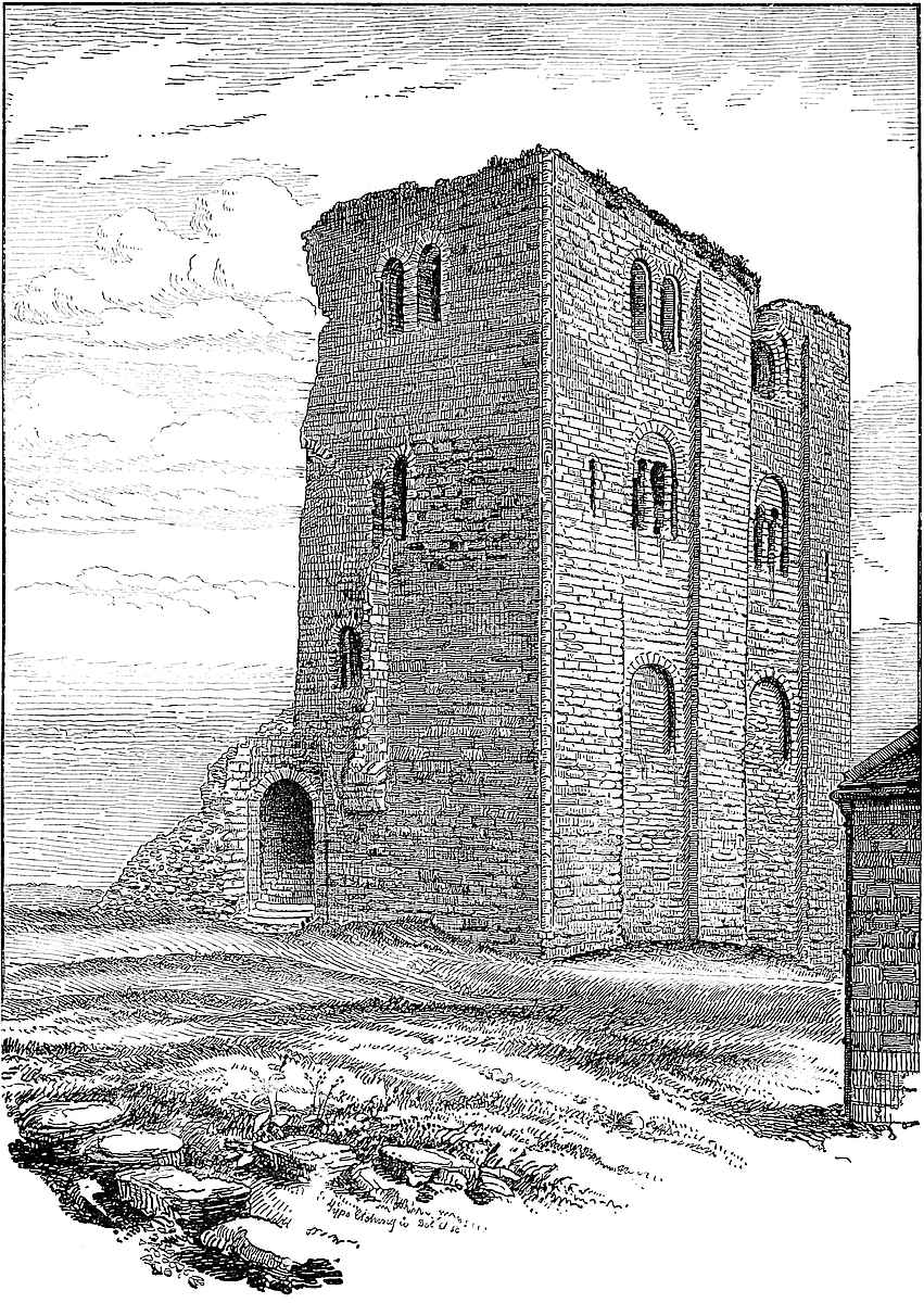
SCARBOROUGH CASTLE.—THE KEEP.
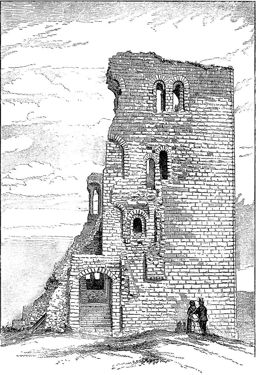
SCARBOROUGH CASTLE.—THE KEEP—SOUTH FACE.
The east, the most perfect face, has the usual flanking pilaster strips, 10 feet 6 inches broad and of a foot projection, which rise unbroken to the summit, and no doubt supported the usual angular turrets, now removed. The angle at which the adjacent faces of the building meet is hollow, and is occupied by a bold round bead, 12 inches diameter; in fact, a three-quarter shaft, but without base or capital. In the centre of the face is a third pilaster, 8 feet broad, and quite plain. On this side the basement floor has no openings. The ground, in fact, is above its level. The first and second floors are marked each by two round-headed recesses, 7 feet broad and a foot deep, the second contains a pair of narrow tall round-headed windows, having side columns, and in the centre a pair of coupled columns, common to both openings. The caps are fluted, and the window arches have a bold torus moulding, the only semblance of ornament throughout the building. The upper floor is marked by no recesses, but there are two pairs of small tall round-headed windows, with square jambs and architraves. The windows composing each pair stand about a foot apart. In the flanking pilasters are two pointed loops, corresponding to the second-floor level, and lighting mural chambers.
The north face probably corresponded with that to the east, with the addition of two loops from the basement, one of which is now closed, as are the two windows above it. One flanking pilaster of this front is gone with its west end.
Of the south face the west end is gone, but what remains is full of interest, as it shows how the entrance was arranged. The face is plain, without any regular pilasters or plinth. Towards its west end is the inner entrance, just beyond which the curtain-wall of the bailey sprang from the keep. This entrance is 7 feet broad, and the depth of the thickness of the wall. The passage is round-headed and ribbed. The inner doorway is round-headed, the outer face segmental. A flight of steps within the passage leads up to the floor of the first story. It is evident from a short pilaster, some springing stones, and certain other indications on the face of the wall, that the entrance was covered here by a small forebuilding. Against the face of the keep was built a rectangular block about 30 feet long and perhaps 20 feet broad, ending against and abutting upon the curtain. It contained a vaulted passage, and over its outer doorway, at its east end, was a large funnel-shaped machicolation for its defence. Within this the vault led on until on the right hand in the keep-wall was the inner entrance already mentioned. There was no portcullis, but above the doorway is an opening or meurtrière, by means of which the entrance could be defended against those who might have forced the outer gate. The ramparts of the forebuilding were on the level of the second floor of the keep, and were reached from it by a small narrow doorway opening from a mural chamber in the south wall. Close east of this is another small door, a little higher, the use of which is not very evident, unless it opened upon a hoard or brétasche a little in advance of the stone parapet. A little west of and below these is a third and shorter doorway, which seems intended for the working of the meurtrière over the inner door. It is connected with a small and very narrow mural staircase.
The interior of the keep is not only filled up so as to hide the basement floor, but its eastern part has been converted into a powder magazine, and is inaccessible. It is said that the magazine includes four rectangular mural chambers, one 14 feet by 5 feet in the south wall, two 6 feet and 7 feet square, in the east wall, and one 5 feet by 6 feet in the north wall, but these have not been examined. The first floor was about 32 feet square, but divided into two nearly equal parts by a bold arch running north and south, and springing from two wall piers. The arch is gone, but the broken wall shows it to have been 4 feet 6 inches thick, and to have carried a solid wall, which divided the second and ceased at the floor of the upper storey. In the east wall of the first floor is a central fireplace of 7 feet opening with a round head and of no projection, round-backed, and with a vertical mural vent. On each side of it is a deep recess of 6 feet 9 inches opening, round-headed, and containing a pair of coupled windows already described. There are two similar recesses in the north wall, one on each side of the cross arch, of which the eastern is at present walled up, but seems to have had besides its windows a small lateral door opening into a dark mural chamber, which occupied the north-east angle. The other recess, west of the cross wall, is open, and its two windows remain. In the south wall is a small doorway which leads into a mural chamber occupying the south-east angle, but now inaccessible. At the other end of this wall is the entrance door, and between it and the cross arch a steep narrow stair leading to the opening above the entrance doorway.
At the second floor the cross-wall was pierced by a small doorway near its south end, of which one jamb remains. This floor also has a fireplace in its east wall, resembling that below, but with a segmental arch, while above it, in the wall, is a semicircular arch of relief. On either side is a recess with coupled round-headed windows, the shutter rebates of which are pointed. In the north wall are two doorways leading into mural chambers, and at its western end a recess and double window, as before. In the south wall are two openings; one, a door leading into a mural chamber in the south-east angle, lighted by a loop already mentioned, and the other a large recess within which are the two doorways opening towards the forebuilding. On the other side of the cross-wall, over the main door, are traces of a large recess with coupled windows.
No fireplace remains in the upper floor, which seems to have been occupied by one large chamber, having in its east wall two pairs of coupled windows in deep round-headed recesses, and the same probably in its north and south walls. There may, indeed, have been a fireplace in the west wall.
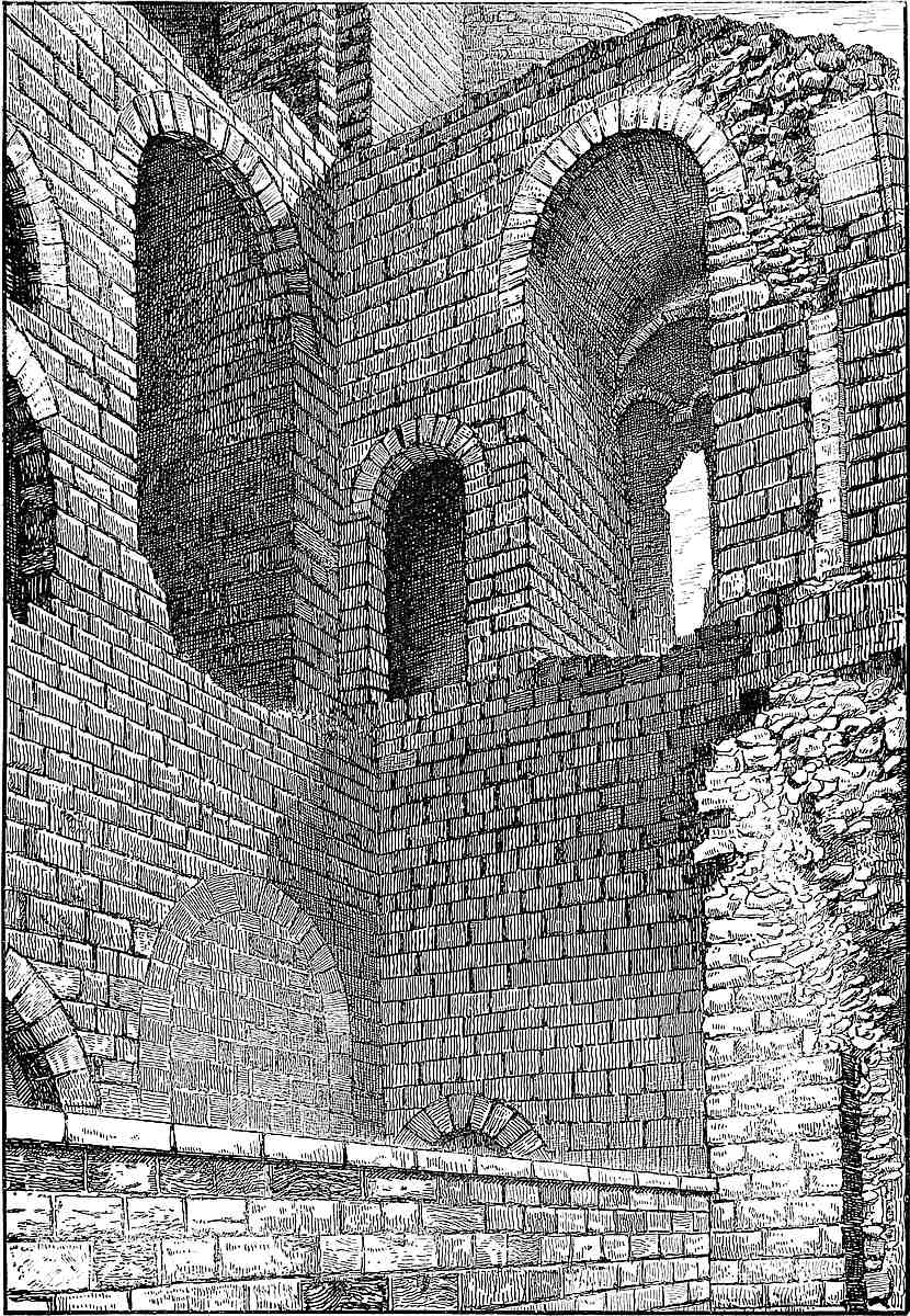
SCARBOROUGH CASTLE.—INTERIOR OF KEEP.
The floors throughout seem to have been of timber. There are no traces of a mural staircase leading from one floor to another, but there may have been such in the north-west or south-west angles. Neither is there any mural gallery surrounding the building.
It is in all respects unfortunate that Scarborough Castle is still regarded as a military post. Here, as at Dover, no one is allowed to sketch or measure within the area, although the force employed to see to the observance of this order renders it practically powerless. But the empty powder magazine is locked up, and effectually prevents a thorough examination of the keep; if this were removed, and the basement excavated, an absolutely correct plan of the keep might be obtained, which now is impracticable.
A county that contains within its borders the castles of York and Richmond may yet be proud of the possession of Scarborough, which, though not superior to those, claims with them equal rank. No doubt the circumstances of each are different. The position of Richmond on the Swale, its ancient Norman keep, early and curious chapel, and the considerable remains of its hall and other domestic buildings, no less than the rank and warlike character of its earlier lords, have invested it with a peculiar and unrivalled interest. At York, the castle, spacious in area, and strong, if not striking in position, played no inconsiderable part in the Norman Conquest; and while surrounded with the works of the Romans and Romanized Britons, claims an origin from those of our Teutonic ancestors whose name is embodied in that of England. The claims of Scarborough to rank and fame are of a different though scarcely inferior character. Its position above the Northern Ocean is wild and grand in the extreme. Its area, defined and protected by Nature, is calculated to contain, not a garrison, but an army; and its keep, in itself equal to Richmond or most other Norman structures, is here not a citadel but the mere gateway and key to what is really the fortress, and which rises from the seashore above and behind it.