Volume 2 — DOVER CASTLE, KENT.
Reading edition
“Est ibi mons altus, strictum mare, litus opacum, Hinc hostes citius Anglica regna petunt, Sed castrum Doveræ, pendens a vertice montis, Hostes rejiciens, litora tuta facit.” —De Bello Hastingensi Carmen, i. 603.
THE tract of chalk which forms and gives character to the isle of Thanet and the south-eastern portion of the county of Kent, rises towards the sea to a line of cliffs upon which the promontories of the North and South Foreland and of Dover are the most conspicuous. The cliff line, however, is not continuous. It is broken at intervals by various valleys and gorges, down which the waters from the interior find their way to the sea, producing havens which in former days and for vessels of light burthen were much in request. Of these waters the chief is the Stour, which at no very remote period, near to the present Canterbury, fell into the head of a considerable estuary, the waters of which, guarded by the ancient fortresses Regulbium, Rutupiæ and Lemanis, maintained Thanet as an island, and gave to the trade of the period free access to the interior of the district. This estuary was not exempt from the general tendency to become silted up. Before the Norman Conquest the waters had receded from Canterbury to the parish thence named Stourmouth, and Thanet from an island had become a peninsula. The process of silting up has been since continued, and the mouth of the Stour carried many miles lower. The river, after a very winding course, falls into and in part forms what remains of the ancient English port of Sandwich, opposite to the anchorage known as the Small Downs.
About three miles to the west of the South Foreland, another and much smaller stream, fed from the lower chalk and greensand, flows down a deep valley, and, reaching the sea between two considerable heights, has given origin to the port, town, and castle of Dover, so called, without doubt, by derivation from a British name represented in the Roman times by Dubris. The town and port lie deep in the valley. Of the heights, a part of that to the west has been rendered famous by Shakespeare, and has long borne his name. That to the east is known as the Castle Hill, so called from the fortress by which, under some form or other, it has been crowned from a very remote period. A position so convenient and so capable of defence would, upon any shore, have attracted the notice of the very earliest inhabitants; for not only was the height strong and the port convenient, but these advantages were found at the point at which the island approached nearest to the Continent, and at which those who crossed the straits, whether as friends or foes, would first make the land, and, if not obstructed, would come ashore. The position, therefore, was of far more than local importance, and would be sure to receive the attention not only of the chiefs of the Cantii, but of the rulers, if such there were, of the whole of Britain. It is therefore probable that haven, town, and fortress date from very nearly the first settlement of the country.
Although the Western or Shakespeare’s Cliff is part of a larger range, the Castle Hill is better suited for defence. It is, in fact, an isolated knoll about 1,000 yards north and south, and 500 yards east and west, the summit being a steep and narrow ridge. Towards the south its boundary is the sea cliff, 320 feet high, and to the west the deep valley of the town. To the east and north are other valleys, less deep but by no means inconsiderable, and the sides of which are steep. Moreover, the whole hill is of chalk, that is to say, of a material easily scarped and capable of retaining any general outline to which it may be cut.
But though, on general grounds, a very remote antiquity may safely be attributed to both town and fortress, it is difficult to find any precise or special evidence on which to rest the claim. Here, as at Durovernum or Canterbury, the Roman form indicates a British origin, and, if the ancient name of the stream be indeed, as asserted, the Dour, may well be derived from it, and the Castle Hill is just the place upon which a British camp is likely to be found. The commerce of the Britons, known to have been carried on with activity through the Cornish ports and the Isle of Wight, has also been claimed for the route through Dover. The actual present traces of British occupation in this southern country are indeed very scanty, and confined to a few names of rivers and hills, a very few of towns or villages, and to occasional entrenchments upon high ground, and of an irregular outline. The great roads, whatever their remote origin, in their present form carry the stamp of Rome upon every mile of their course, and the oldest known works in masonry are due to the same people, while the general topography, all that relates to property and self-government, hundreds, lathes, rapes and tythings, parish and hamlet, grange and farm, and the crowd of bourns, dens, hams, hangers, hirsts, ings, tons, wolds and worths point with overwhelming force to the English settlers. Even the tenure in gavelkind, claimed as a British custom, and known in Wales by the expressive name of “Randyr” or “partible” land, is by most legal antiquaries regarded as Teutonic.
Although Cæsar does not mention Dover by name, there can be no doubt that his fleet lay before it in August, B.C. 55, the period of his first invasion of Britain. Dr. Guest has clearly demonstrated that the Portus Icius whence he sailed was a small and now silted-up haven between Cape Gris Nez, the Ician promontory, and Wissant, whence a ten hours’ course brought him in the morning abreast of Dover. Here he found the natives, in great numbers and armed, drawn up to oppose his landing. He therefore anchored in Dover Wick, the roadstead east of the town, to give time for his slower ships to arrive, and thence proceeded to Deal, where he probably landed with two legions, or from eight to ten thousand men. Dr. Guest has pointed out that the word Icius coincides closely with the Irish name for the English Channel, “Muir n’Icht,” “the Ician Sea,” “icht” being a form of “uch” or “ucha,” upper in height, which plays so important a part in the names of places in Wales and the north of Scotland. It was natural that the Channel should be named from its most remarkable feature, and to this day its name in Dutch is “De Hofden,” or “the heights.”
Cæsar stayed but three weeks in the country, and may not have visited Dover; but as, when he returned in the following year with a much larger force, he seems to have embarked and landed at the same points, he must have been familiar with the aspect of the port from the sea. As on this occasion he traversed Kent and crossed the Thames, he probably left no dangerous force behind him at Dover, which he does not mention, and which clearly was not then made a rallying point by the Britons. Had the heights been held in force, he would probably in the first instance have reduced them, or at any rate have mentioned the fact in his narrative. During the century that followed Cæsar’s appearance, Rome took no active part in British affairs, but it is probable that a considerable trade sprang up between the island and the Continent, and the Britons made great advances in commerce and civilisation. Towns were founded and coins struck. The next military invasion took place, A.D. 43, ninety-eight years after the first appearance of Cæsar, and under the reign of Claudian, and command of Aulus Plautius, who landed with four legions. The Cantii then held a tract nearly corresponding to the present county of Kent. Durovernum had been founded amidst its indigenous alders, and Camalodunum, beyond the Thames, was the chief city of the Trinobantes. Where Plautius landed is not precisely known. Probably at several points on the open beach between Rich borough and Laymen. Whether the Britons mustered north or south of the Thames is also unknown; but, when Claudian followed his lieutenant, the way lay open to that river, and he marched at once upon Camalodunum, where the Trinobantes were put to flight. Plautius probably subdued the country as far west as the Axe and the Tamar, and his progress may, it is thought, be traced by the remains of his rectangular camps opposed to those of larger area and irregular outline thrown up by the retiring Britons. As, in the year A.D. 40, Caligula had caused a lighthouse to be set up on the heights of Boulogne, it is not improbable that Plautius was the builder of the corresponding tower at Dover.
Ostorius Scapula is said to have occupied with a camp the Castle Hill. He, Suetonius Paulinus, and Agricola were busied mainly with the midland and northern parts of the island, and the southern province, Britannia Prima, seems to have been at peace. Roads were laid out, towns built, the metals were smelted, and agriculture prospered. Dubris (Dover), Durobrivis (Rochester), Rutupiæ (Richborough), Lemanis (Lymne), Regulbium (Reculver), and Anderida (Pevensey), came afterwards into notice as towns or havens. The Watling Street, which ran from Canterbury by Rochester northwards, seems to have been commenced at Dover. There were indeed roads from Canterbury to Lymne and to Richborough, but Dover would be the port reached by the production of the road in a straight line from Canterbury. In the reign of Valentinian, A.D. 364–7, a cohort of the Second Legion of 1,100 men was stationed at Dubris, where stamped tiles show them to have built a bath, and which is mentioned as a port in the Iter of Antoninus and as a town (civitas) by the geographer of Ravenna. In the time of Constantine, Dubris was one of the six ports south of Thanet, under the Count of the Saxon shore, the others being Rutupiæ, Regulbium, Lemanis, Anderida, and Adurnus (Portsmouth). It is, however, not included in the list of the twenty-eight towns existing when the Romans retired from Britain, of which Rutupiæ was one. Still, even if Dubris were one only of three heads of the Watling Street, its importance under the Roman sway was considerable.
To the Roman period is to be referred the burial-ground laid open near the edge of the cliff in 1797, and the bath discovered on the brook west of St. Mary’s Church. No mention is made of a Roman fortress, nor was it in accordance with the practice of that people to place a permanent camp, still less a military station, upon a height so inaccessible as the Castle Hill. The existing earthworks show no traces of Roman outline, nor, when they had possession of the whole district, was there any need to fortify the lighthouse. The lighthouse alone, of the works upon the hill, can with certainty be pronounced to be Roman, but this, of course, implies the existence and employment of the port. All that the topographer can affirm is that the earthworks do not now present, and, so far as description may be relied on, do not appear ever to have presented, anything of a Roman character.
Kent was probably the part of Britain first invaded by the Northmen, and certainly the first actually subdued and settled. It was the only independent state established and maintained by the followers of Hengist, the Jutes, a people who did not contribute largely to the conquest of Britain, neither did they occupy any considerable portion of the conquered country; but what they did retain became and still remains intensely Teutonic, and their early supremacy, during the conversion of the English to Christianity, is marked by the fact that their chief city became, as it has since remained, the ecclesiastical metropolis of the island. Dover was a considerable Jutish port, and before long was regarded as the key of England. Very probably the inner earthworks still to be seen, though too much altered to be recognisable, were the work of this people, and the collegiate church of St. Martin, founded in the town by Wihtræd, King of Kent (690–725), is said to have been removed by him from the Castle Hill. In the time of Alfred, Dover was placed in the bailiwick of Stouting, and the lathe of St. Augustine. Its history, however, properly so called, does not begin till the reign of the Confessor, whose charter to the Cinque Ports, which John is said to have inspected, was confirmed by many later kings.
In September, 1051, Eustace, Count of Boulogne, brother-in-law to King Edward, paid a visit to the English Court at Gloucester, and returning through Canterbury there rested his escort, and thence went to Dover on his way homeward. Before entering the town, he and his men put on their coats of mail, and attempted to take free quarters in the houses of the burghers. This led to a fight in which much blood was shed, and the Count finally, being expelled the town, returned to Gloucester with his complaint. The subsequent tale has often been told. Godwin, then Earl of Kent, took part with his injured countrymen, and withstood the strong Norman interest about the king, and was, in consequence, banished. Godwin proposed, says Malmesbury, “Ut magnates illius castelli blande in curia regis de seditione convenirentur.” Whether “castellum” can be taken for more than the fortified town is uncertain. It is not probable that Eustace would have ascended to the castle, since he sought quarters in the town. On the whole this passage can scarcely be taken to prove the existence at that time of a regular castle on the hill. Nevertheless, the existence of such a castle at that time is exceedingly probable, for in 1064–65 Harold, says William of Poitiers, swore to Duke William that, on the death of the Confessor, “se ... traditurum interim ipsius militum custodiæ castrum Doveram, studio atque sumptu suo communitum, item per diversa loca illius terræ alia castra.” Eadmer is more precise. In his account Duke William insists, “et insuper castellum Dofris cum puteo aquæ ad opus meum te facturum.” Malmesbury says, “Castellum Doroberniæ (Dubris) quod ad jus suum pertineret.” Here there can be no mistake as to what is meant. A well in the town could be of no special value, but a well on a chalk hill 290 feet above the water springs was an addition to the castle worthy of special notice. Such a well, moreover, was a very laborious work, and must have taken some time to complete. Harold’s oath is no doubt involved in a good deal of doubt and uncertainty, but the tale may at least be taken to show that there was, before the Norman conquest, a castle upon the hill, now crowned by the Norman keep, and that it had been strengthened by Harold. Malmesbury here, as in his account of the fray with Count Eustace, for Dover puts Canterbury, evidently in error.
Domesday Book opens with Dover. “Dovere tempore regis Edwardi,” &c. That king held two parts of half its rents, and Earl Godwin the other third, that is, the earl’s penny. The burgesses provided the king with twenty ships annually for fifteen days, in each twenty-one men. The king’s messengers also had certain valuable privileges, showing that the port lay in the usual route to the Continent. There was a mill at the entry to the port, much in the way of the shipping. The castle is not mentioned, but we read of the Gildhalla, or Guildhall, of the burgesses. The town, though thriving, had recently been burned, and the rent reduced in consequence.
The Normans landed, as their Teutonic ancestors had landed centuries before them, beneath the ancient walls of the Roman Anderida, which, under the name of Pevensey, had become an English, and was to become ere long a Norman fortress. Pevensey is a haven no longer, but within its circuit may still be seen huge fragments of Roman and Norman masonry, and the simpler, but, at least, equally durable mound of its English occupants, a grand and striking composition, and, to the instructed observer, eloquent of great events. William took possession of the ruins, and, on the following day, marched upon the battlefield, hastily fortifying with wood and earth the hill of Hastings in support of his position. After the battle Romney first felt the weight of the Conqueror’s hand, and he then turned to Dover. The castle was, says William of Poitiers, impregnable, and the town even then considerable; but the people, though assembled in vast numbers, had no leaders, and town and castle were at once surrendered, though in the transfer, either by design or accident, much of the town was burned. William paused here eight days, detained by sickness among his troops. He treated the people with great lenity, placed a Norman garrison in the castle, to the defences of which he added, and then proceeded towards the Thames, receiving the submission of Canterbury and Rochester on his way. Kent was placed under the command of Bishop Odo, who held Dover as its military centre. This continued to be its position, and in 1074, when the fierce Jutish blood broke out, and the men of Kent, headed by Eustace of Boulogne, rose against William, their first object was to gain Dover Castle, to which they laid siege. Its defences, whether English or Norman, were strong, but the attack was sharp. Bishop Odo and Hugh de Montfort, who had the castle in charge, were absent, but they exerted themselves in the county, and the castle was relieved. Towards the end of the reign the town is said to have been walled, and to have had ten gates. Its position, as the most important of the Cinque Ports, seems to have been established, to which its castle largely contributed. The five ports were Hastings, Romney, Hythe, Dover and Sandwich. Winchelsea and Rye were among the members. Their service was to provide fifty-seven ships annually, of which number Dover furnished twenty-one.
Important as the castle continued to be under the reigns of the Plantagenet and Tudor kings, its history does not possess any very particular interest. It was not the scene of any very remarkable event, and, though accounted the key of the kingdom, was not in any very intimate manner bound up with its history. It has always been held by the Crown and governed by a constable, usually a man of eminence, of which officials Lyon gives a list of 138. Three barons of the house of Fiennes held the office under the Conqueror, Rufus, and Henry I., and in their time seem to have been built the outer curtain and many of its towers. Walchelin Magminot, placed in office by Stephen, held the place against him in 1137, and in 1138 surrendered it to the queen, just before the battle of the Standard. Stephen died at Dover, probably in the castle, and Mr. Puckle has fought gallantly for the recent discovery of his remains. Henry II. is supposed to have built the keep and the wall of the inner ward in 1154, soon after his accession to the crown, and, if so, it was probably the actual work of one of the Barons Fiennes, who held the office of constable in that reign. Of these lords, the last, James Fiennes, was constable at the accession of Richard I., and in 1191 received, as a prisoner in the castle, Geoffrey, Henry II.’s natural son, on his way to take up the archbishopric of York. He was taken from the sanctuary of St. Martin’s church, and imprisoned by order of the Bishop of Ely, the chancellor. For this outrage Fiennes was suspended, and eventually the chancellor was excommunicated and banished. In 1198 the constable was one of the five officers appointed to inspect the treasures of the church of Canterbury. In the reign of John, the constable was Hubert de Burgh, to whom it fell to defend the castle against Prince Louis and the French invaders. Louis made great attempts to win over De Burgh to his party, but without success, and upon his final refusal he laid siege to the castle. Trebuchets and petraria, and much siege artillery were brought over from France, and a covered way was run along the slope outside the castle ditch on the north-west quarter. Wooden towers (Malvoisins) also were erected on the edge of the ditch to quell the fire from the walls, which were actually shaken by strokes of the ram. Also a small colony was established in temporary huts, so as to give the siege the aspect of a blockade. Hubert, however, was a true and loyal subject of England. He regarded his charge as held under his sovereign, whoever that sovereign might be, and his castle as the “clavis Angliæ et repagulum.” He returned attack for attack, stone for stone, until the death of John, by removing much of the cause of dissatisfaction, led to the retirement of the French from the country. The great spur-work in advance of the northern gateway, and which still, though much altered, remains, is probably the work of De Burgh, no doubt suggested to him by the direction of the French attack. Henry III. was here in state in 1255, on his way from Spain, and in 1259 the castle was in the hands of the barons, who refused to allow his brother Richard, King of the Romans, to enter the place until he had sworn to adopt their cause. Henry recovered the castle in 1261 from Hugh le Bigot, but was unable to hold it, and was refused admission when, with his brother and the Earl Mareschal, he presented himself before the gate in 1263. In the great struggle, Henry held the Tower of London, and the barons the castle of Dover. After Lewes, the Princes Edward and Henry were for a time held in durance in Dover. In 1265, when the prince had the upper hand, and Kenilworth had fallen, fourteen nobles of the royal party were imprisoned in the keep of Dover. Here they defended themselves, turning the tables upon their captors, who, attacked from without by Prince Edward, and thus placed between two fires, surrendered the castle. The Countess of Leicester, who was within it, was allowed to retire to France.
On his return from Palestine, after his father’s death, in the summer of 1274, Edward I. landed at Dover. He again visited the castle in 1278, 1296, and 1299. Dover was his usual port when he visited or returned from the Continent, and in his time the castle was maintained and strengthened, and some of its most considerable parts, such as the Constable’s Gate and St. John’s Postern, are of the conclusion of the reign of Henry or early in that of Edward, and most probably the latter.
Edward II. was here in the January following his father’s death, and here he embarked for Boulogne on the occasion of his marriage in 1308, and here he received the queen. Edward III. was not infrequently at Dover, but is more likely to have lodged in the Maison Dieu than in the castle. He probably drew troops from hence when he sailed from the port on his celebrated secret expedition to Calais in 1348. In the reign of Henry V. the Emperor Sigismond was received at the castle as a visitor, and from hence the king embarked his army for France in 1421, as did Henry VII. in 1491.
Henry VIII. suppressed the Maison Dieu, the celebrated foundation of Hubert de Burgh, within which very many kings and princes had been entertained, but the castle was an object of his special care, and was repaired and garrisoned. Henry also built the blockhouses of Sandown, Deal, Walmer, and Sandgate, and placed them under the charge of the Constable of Dover. Three bulwarks also were constructed under the cliff and upon the pier of the harbour. Later on the castle fell into neglect, and in the reign of Charles I., being garrisoned by a small force, and but little cared for, it was taken by surprise and held for the Parliament. In 1648 the Kentish royalists made a vigorous effort to recover it, but were repulsed by Algernon Sydney, then its governor.
DESCRIPTION.
Dover Castle is called by Matthew Paris “the very front door of England,” and described by William of Poitou as “Situm est id castellum in rupe mari contigua quæ naturaliter acuta undique ad hoc ferramentis elaborate incisa, in speciem muri directissima altitudine, quantum sagittæ jactus permetiri potest consurgit, quo in latere unda marina alluitur.” It presents a good combination of the defences of several architectural periods, the general result being a concentric fortress, the growth of many centuries, and which, a century ago, presented much both of earthwork and masonry of great and unmixed antiquarian interest. More recently, however, the works have been delivered over to the military authorities of the country, and the result has been a series of alterations, additions, and removals, necessary, it is in all courtesy to be presumed, for the defence of the country, but very destructive of the ancient features of the fortress. The ancient earthworks have been scarped, extended, retrenched, and tunnelled, barracks and magazines have been built, the keep has been converted into storerooms and water-tanks, and in its basement are two powder magazines. In its present condition, and having regard to the strict regulations, prohibiting even the use of the pencil, under which the whole is placed, an accurate examination of what remains of the ancient works, whether in earth or masonry, is almost impracticable.
The British camp was oblong, following the figure of the hill. It was composed of a deep and broad ditch, the contents of which were in part thrown inwards and upwards so as to form a bank. The area thus enclosed measured within the bank about 875 yards by 350 yards, the latter being its diameter at the cliff, by which it is cut off, the northern end running to a point. This main ditch has probably been deepened and more or less altered during the Norman period, and it is now connected with various bastions, hornworks, and caponnières, but its general outline is sufficiently clear, and it may, from internal evidence, be presumed to be British. Within the area, rather nearer to its northern end, a second earthwork, also composed of bank and ditch, has been thrown up. This includes the lighthouse tower, and is therefore called the Roman ditch, but there is nothing about it of a Roman character, and it is far more probable that it was the work of the English, and formed the inner defence of the castle which Harold undertook to surrender. The space between this and the great earthwork forms the outer ward of the Norman castle; the inner work has been divided into two parts. That to the south, containing the lighthouse, forms the middle ward; that to the north contains the keep, and is the inner ward. The lighthouse has been employed as a belfry to the adjacent church of St. Mary, which is the subject of an excellent memoir by Mr. Puckle, though he can scarcely be admitted to establish its connexion with the British church. The two are undoubtedly the oldest buildings within the castle area.
The Keep and Inner Ward are Norman, of the reign of Henry II., but the curtain and most of its towers have been refaced or rebuilt, a great part recently, but more or less on the old lines. The plan is an irregular polygon, about 120 yards each way, with fourteen rectangular mural towers of no internal projection, and not rising above the curtain, which, however, is lofty. Two of those to the south-west take their name from Magminot and one from Gore. The walls were of flint rubble, quoined with ashlar, and battering outside at the base, the top of which is marked by a bold cordon of stone. Upon the sides of some of the towers are bold machicolated openings from garderobes. The keep stands detached in the centre of the ward, and within the area, built against the walls, are several buildings, as Arthur’s Hall, the guard chamber, and the officers’ quarters, some of early English character, others modern.
There are two entrances, the north, or King’s Gate, and the south, the Duke of Suffolk’s, or Palace Gate. The gateways are vaulted passages, with a flat segmental arch, opening externally between two square flanking towers. There is a groove for a portcullis, and the vaults have an early English import. Each of these gates is defended by an additional work. A sort of hornwork is thrown out in advance, enclosed within a wall with towers, and with a second gate placed obliquely to the first, to allow the approach to be commanded. The north, called the King’s Gate, is tolerably perfect. The southern outwork is nearly destroyed. It had two gates, one to the south, connected with which was the tower containing a well, and one to the east, called King Arthur’s Gate, close to which was the Armourer’s Tower, and near this was Earl Godwin’s Postern. The masonry of this inner ward was probably of the date of the keep. It was included within a broad and deep ditch, now incomplete, on the southern front.
The Middle Ward includes the southern half of what was probably the English earthwork. Its southern two-thirds is rounded, but at its base are, or were, walls and towers connecting it right and left with the curtain of the outer ward, which it thus divided into two parts. In advance of this work were three towers: two, to the east and west, Clinton and Mortimer, were square. Both seem to have been of Norman date. The central tower to the south was circular, and was called Valence. It was, no doubt, later, probably of the reign of Henry III. The foundations of Clinton Tower were laid open and removed in 1794. A fragment of Mortimer’s Tower remains. Valence Tower was destroyed in the last century. The gatehouse of the ward is called Colton Gate. It is Norman, but an octagonal story has been added to the square base. The curtain connecting these towers is gone, and the lofty south bank has been scarped, and its outline changed. In this ward is a well 380 feet deep, once covered by a tower.
The Outer Ward is contained within a curtain, much of which is reduced by an internal ramp to a parapet wall. Upon the three landward sides it is narrow, and chiefly occupied by the ditch of the middle and inner wards. Upon the remaining or southern side it expands and includes a large space between the middle ward and the cliff. Its circuit is only not complete because its walls rest at either end upon the cliff. The plan of the wall is irregular, with an occasional angle or shoulder for raking the ditch. Exteriorly it rises from the outer dry ditch, and upon it are twenty-seven towers of various dates, figures, and dimensions, square, circular, and multiangular. Most of those on the western face are simply hollow bastions, and have no internal projection. Those on the eastern face are mostly mere sentry-boxes, or bartizan turrets of small dimensions. Upon the seaward front, where the cliff is perpendicular, there is no wall. The ingenuity of the engineer has been exercised on the landward and weaker sides. Five of the towers are connected with gates. These towers, commencing at the south-west angle of the ward, near the cliff, are: 1. Canon’s or Monk’s Gate, now destroyed; in it was a well. 2. Rokesley’s Tower, semicircular. 3. Fulbert de Dover’s Tower, square; near which was long the office of the “bodar,” or sergeant-at-arms, to whom all civil warrants of arrest for debt or breach of the revenue laws were addressed. Fulbert’s Tower was also his prison. 4. Hirst’s Tower, semicircular; it commands a shoulder or re-entering angle in the wall. 5. Arsick’s Tower, semicircular. 6. Gatton Tower. 7. Peverill’s, Beauchamp’s, or Marshall’s Tower. This is also the gatehouse between the two divisions of the outer ward, which was strong, with a ditch on the south front, and a drawbridge. It was also the marshal’s prison. 8. Port, Gosling, or Queen Mary’s Tower, having been repaired by that sovereign. 9. Fiennes’s Tower, or the Constable’s Gate. This is one of the grandest gateways in England. It is in plan a triangle with its obtuse angle presented to the field. The angles at the base fall within the line of the curtain, and are capped by two large drum towers. The salient angle in like manner is capped by an oblong tower, rounded at each end and flat in the centre, through which the entrance passes. These three towers are large and lofty, and are connected by an embattled curtain. Within the triangle a central tower rises to a still greater height, and commands the whole. The entrance passage is broad and vaulted, and provided with gates and a portcullis. Within, it opens upon the level of the outer ward; without, it terminates abruptly upon the scarp of the ditch, there about 50 feet deep. From this gateway a bridge communicates with the opposite bank. A single lofty pier rises from the centre of the ditch, and from it an arch springs to the outer abutment, carrying a regular roadway and parapets. In the opposite direction the parapets alone spring, as two arches, from the pier to the gateway, and serve to steady the pier, but the roadway is omitted, and its place supplied by a drawbridge. This arrangement is not uncommon, but is here specially necessary, owing to the height and consequent weakness of the pier. Upon the counterscarp of the ditch is a tête-de-pont, from which a steep road descends by a traverse towards the town. This gate, though open, is but little used. The ordinary gate is modern, and near the site of Canon’s Gate. The Constable’s Gate is of the Decorated period. Its interior is said to be very curious, but is not shown.
Sixteen towers, including Clopton, Godsfoe, Magminot (4), and Crevequer’s Towers (2), protect the north-west face. Clopton is a hexagon; the name of Magminot is borne by four towers. The two towers bearing the name of Crevequer mark the position of the great postern, a very curious work. Passing from the north gate of the inner ward, a range of arches cross the ditch and the outer ward, and terminate abruptly in a large low pier with salient angles to the right and left. Opposite to the pier, and no doubt at one time connected with it by a drawbridge, rise a pair of circular towers (Crevequer), connected by a heavy curtain and flanked by lesser towers (Magminot) at short distances, all forming part of the enceinte of the outer ward. Towards the field the curtain has a salient angle, and from its base a covered gallery descends into the outer ditch, and there reaches St. John’s, a drum tower built in the middle of it. The gallery passes through the first story of the tower, and terminates in the counterscarp, in a circular chamber cut in the chalk, and from this chamber three tunnels radiate to different parts of the glacis, of which one formerly led to a distant postern, and another still communicates with the old spur-work, attributed to Hubert de Burgh, and converted into a modern ravelin. Two other tunnels, apparently of Edwardian date, leave the main gallery under the castle wall, and the basement floor of St. John’s contains two sally ports, opening into the bottom of the ditch. The modern access to these galleries is by a shaft sunk in the pier of the old drawbridge, but the old entrance was nearer the curtain. The French siege of 1216 was directed upon this quarter. The approaches were made from the west below the Constable’s Gate, and under cover of a trench and breastwork. While the attack was impending Sir Stephen de Pencester brought a reinforcement into the castle by the postern under Godwin’s Tower. De Burgh, taught by experience, threw up the advanced work which still, under a changed form, covers the northern end of the castle, and it was to reach this in safety that the gallery from St. John’s Tower was executed.
Fitzwilliam’s Tower (18), placed about 80 yards east of the north gate, was connected with a second postern, not unlike the last, and now connected with a caponnière. Beyond this are 19 and 20, two watch turrets, and farther on 21, Albrinci’s or Avrenches’ Tower. This contains a third postern of peculiar arrangement. It is a low, polygonal structure, placed on a shoulder on the ditch, so as to rake its continuation southward. It was reached by a covered gallery from the south gate of the inner ward, which is continued through its basement so as to open on the counterscarp of the main ditch. Connected with this gallery was Veville or Pencester’s Tower, placed upon the curtain which on this side closed the connexion between the two divisions of the outer ward. Of the remaining towers, five in number, three are called Ashford’s, and near one of them was another well. This part of the defence has been completely remodelled. The names of the several towers are those of the knights by whom they were built, or whose duty it was to defend them, for to no castle in Britain, not even to Richmond, was the practice of tenure by castle guard so extensively applied as to Dover, and very numerous and valuable were the Kentish manors so held, amounting to 230½ knight-fees, of which 115¼ were attached to the office of Constable.
The Keep.—This is a very fine example of a late Norman keep. It is very nearly square, being, at the base above the plinth, 98 feet north and south by 96 feet east and west, with a forebuilding 15 feet broad by 115 feet long, which covers the east side and the south-east angle of the main structure. The angles are capped by pilasters 19 feet broad and of 5 feet projection, which meet to form a solid angle, and, rising to the summit, become the outer faces of four square turrets. On each of the three free faces is an intermediate pilaster, 15 feet broad by 5 feet projection, which rises to the same height with the parapet, and forms a bay in its line. There is a battering plinth, 6 feet high, from which the pilasters rise, and the total height of the wall is 83 feet, and of the turrets 12 feet more, or 95 feet. The base of the keep is 373 feet above high-water mark. The top of the plinth is marked, on the face of the pilasters, by a bold cordon or roll, and there are two sets-off of 6 inches common to both walls and pilasters, one at the first and the other at the second-floor level. The walls are of unusual thickness, even for a Norman keep. That to the west, between the pilasters, is 21 feet reduced to 19 feet at the first and to 18 feet at the second floor. The north wall is 17 feet, the south 19 feet, and the east 18 feet. The cross wall, which runs north and south, and divides the building nearly equally, is 11 feet at the base, and reduced to 7 feet and 6 feet at the top story.
The main entrance is in the east face, near its north end, at the second-floor level. The forebuilding which covers it is the finest in England. It is in fair preservation, all but its roofs and part of its east wall, which are modern. As at Rochester, it is of masonry inferior to the keep, at least outside, and there is no cordon at the base of its pilasters, but it contains within more ornamental work than the keep, with which it is so intimately connected that it cannot be an addition. In the north-east and south-west angles of the keep are well-staircases remarkably commodious and well lighted. They are 14 feet 6 inches in diameter, the stairs being 6 feet 6 inches and the newel 1 foot 6 inches. They rise from the basement to the roof by 114 steps, and communicate with each floor, the two lower by lobbies, the upper and upper gallery by branching passages. From the north-east lobbies doors open into the two tiers of vaults below the upper part of the forebuilding. The extraordinary thickness of the walls is intended to allow of the construction of a very unusual number of mural chambers, of which there are altogether twenty-seven. Besides the main entrance there seems to have been one at the first-floor level, also from the forebuilding. Others have since been made, one probably in the fourteenth century, direct into the basement, and another very recently into the base of the south-western staircase. Besides these, divers loopholes have been converted into doors, to give external entrance to the basement mural chambers which are used as water-tanks and powder-magazines.
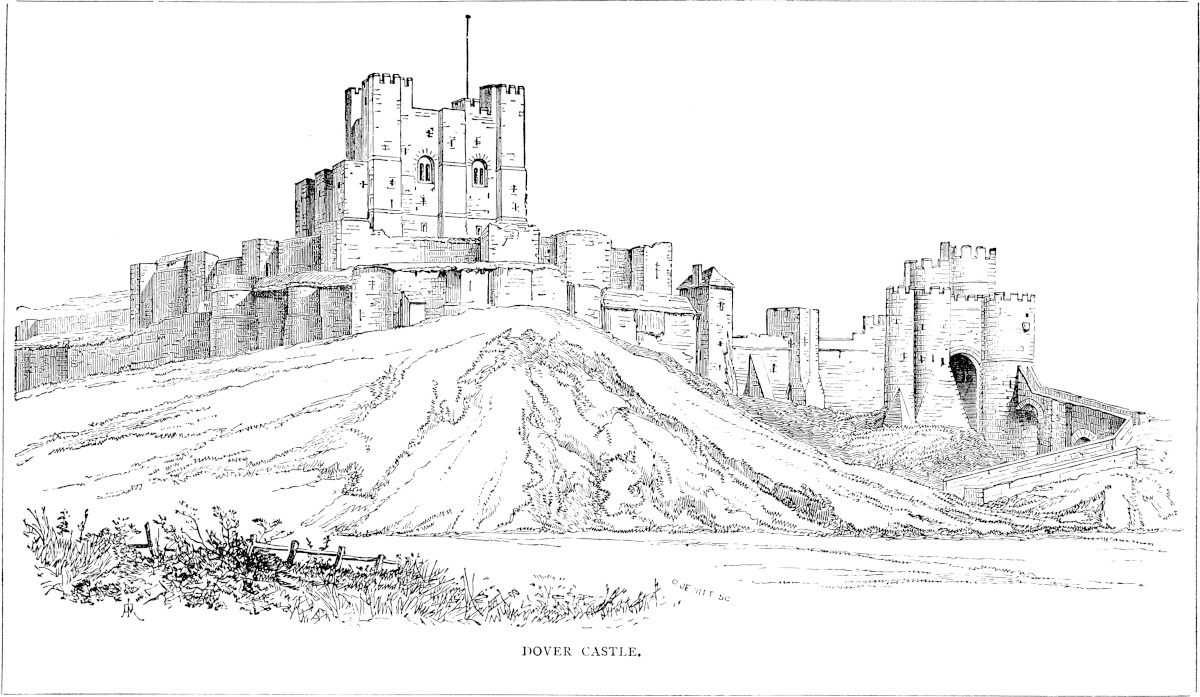
DOVER CASTLE.
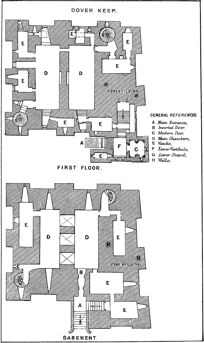
DOVER KEEP.
Wyman & Sons, Gᵗ. Queen Sᵗ. London.
GENERAL REFERENCES.
Main Entrance,
Inserted Door,
Modern Door,
Main Chambers,
Vaults,
Lower Vestibule,
Lower Chapel,
Wells.
FIRST FLOOR.
BASEMENT.
The basement.—There is some doubt about the original level of this floor. At present it is 9 feet above the ground outside, but it contains two doors, the sills of which are 6 feet or 8 feet below the floor, and on opening the ground near the centre of the keep a pavement was found at the same level, so that the floor may have been filled in with earth and raised. If so, however, there must have been some kind of stair to supplement the well staircases, for the floor of their lobbies is certainly at its original level. The cross-wall between the two chambers is pierced by three plain round-headed arches of 11 feet opening.
The east chamber, 50 feet by 20 feet, has in its north end a deep recess, and a loop up to which the sill is stepped, while the arch overhead rises as the recess contracts. It is evident that the recess at the south end was similar, but has been converted into a doorway. This is the opening in general use, from the first landing of the exterior staircase. The wall here is 24 feet thick, and there are rebates for two doors, with bars within each. The arches are segmental and the angles rounded off. The alteration seems to have been made in the Decorated period, with a trace of later work. Close east of this door, and 6 feet below it, is another door, now partially concealed, which led into a vault 28 feet by 15 feet, occupying the south-east angle of the building. In its south wall a door leads into a second vault, 23 feet by 15 feet, below the lower vestibule and chapel. Each vault had a loop towards the east. They are now used as water-tanks, and reached by external openings. Returning to the east chamber, in its east wall are two doors, one at its north end and one near the middle, now blocked up. The northern door opens into the lobby of the north-east staircase, and from it a door led into a vault 28 feet by 12 feet, in the forebuilding, now used as a magazine, and entered through the outer wall. The middle door probably led into another vault, of which nothing is known. Thus at the ground level of the forebuilding there are three, if not four vaults, all originally entered from the keep. They are about 6 feet high to the arch-springing.
The west chamber, 50 feet by 16 feet, has a large recess and loop in each end, and in the west wall two doors, one opening into the lobby of the south-western staircase, where is the modern door, and the other, now blocked up, which led into a mural chamber 39 feet long by 12 feet broad, now a powder-magazine, and entered from the outside.
The first floor also contains two main rooms which communicate by a small door near the north end of the cross-wall.
The east chamber, 53 feet by 22 feet, has a recess 7 feet wide in its south end, which ended in a loop, now converted into a window. In its right or west jamb is a fireplace; in its left a door opening into a mural chamber 18 feet by 11 feet, with a loop to the south, and from the east end of which a door opens upon a staircase of the forebuilding. This door and the window above it are of Tudor date, but there are indications that there was an original door here, of which the Tudor frame is a replacement. In the exterior wall is an arch of relief in fine ashlar, which matches in size with the vault within, and looks as though intended to protect an original door. In the east wall of the great chamber is a door opening into the lobby, in which six steps descend to the north-east staircase. From this lobby a door leads into a vault 24 feet by 12 feet, with a recess in its north and south walls, and a loop in its east end. From this a short passage leads into a second vault, 17 feet by 2 feet, with a loop to the north. These two vaults are placed below the upper vestibule and great guard-room of the forebuilding. In the north wall of the great chamber, at the east end, a small door opens into a mural gallery, 16 feet by 4 feet, with a loop to the north, and which ends in a chamber 5 feet by 6 feet, also with a loop to the north. Above this gallery is a recess 7 feet wide, raised about 10 feet from the floor, to clear the gallery. Its loop is replaced by a modern window.
The west chamber, 52 feet by 20 feet, has also a 7-feet recess in its south end, with a modern window, and in its east jamb a door opening into a mural chamber, 13 feet by 9 feet, with a south loop, and a fireplace in the east wall. This, and the fireplace already mentioned, are placed back to back, and, though with Tudor fittings, may possibly be original. In the north wall of the great chamber is a high recess and window, similar to that in the east chamber. In the west wall are four openings; that at its north end opens into a chamber in the north-west angle, 23 feet by 10 feet, with loops to the west and south. From it branches a passage 18 feet by 4 feet, in the north wall, which leads under the high window recess to a chamber 7 feet by 6 feet. Both passage and chamber have loops to the north. Next follows a window recess of 6-feet opening at the floor level, rising by four steps to the modern window; then a door opening into a mural chamber, 20 feet by 9 feet, with a fireplace in the east wail and two loops to the west. Finally is a door opening upon the lobby which leads to the south-west staircase, rising three steps, and having a loop to the west. Besides the three fireplaces in mural chambers, there were two others under arches of 12 feet span, one in the centre of each face of the cross-wall. These, however, are closed up. In the same wall, at the north end, is a door between the two chambers.
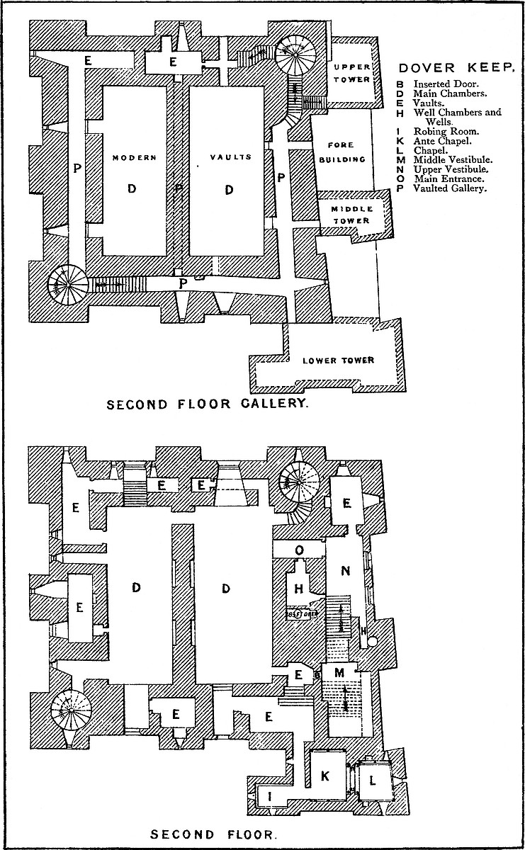
DOVER KEEP.
Wyman & Sons, Gᵗ. Queen Sᵗ. London.
BInserted Door.
DMain Chambers.
EVaults.
HWell Chambers and Wells.
IRobing Room.
KAnte Chapel.
LChapel.
MMiddle Vestibule.
NUpper Vestibule.
OMain Entrance.
PVaulted Gallery.
SECOND FLOOR GALLERY.
SECOND FLOOR.
The second floor is the main or state floor of the building, and that into which opens the great entrance. As in the keeps of London, Rochester, and Hedingham, it had two tiers of windows, the upper passing through a mural gallery. Early in the present century this floor was covered in by two large brick vaults, slightly pointed. The object was to convert the ramparts into a platform for cannon. This clumsy addition completely conceals the upper half of the walls and destroys the effect of two very fine chambers.
The east chamber, 55 feet by 24 feet, is entered on the east side, near the north end, by a large, full-centred doorway, flanked outside by nook shafts. From this a vaulted passage, 5 feet broad, traverses the wall, here 16 feet thick, and descends by eight steps into the main chamber. This inconvenient height was evidently given to secure headway for the vault below the vestibule. In the entrance passage, on the left or south side, a door opens into the well chamber, a vault, 16 feet by 8 feet, with a loop to the east upon the great staircase. At the south end of the vault, upon a step, is the well, 4 feet diameter and 289 feet deep, lined, as far as can be seen, with ashlar. In the east wall is a recess for a spare bucket. Near the entrance, at the north end of the east wall of the great chamber, a door leads into a curved passage which descends eleven steps into the north-east staircase. At the south end of the same wall a large arch, 5 feet above the floor, opens into a mural chamber 8 feet by 7 feet. This arch has been reduced by modern brickwork, to support the great vault. In the same chamber a loop opens upon the grand staircase, and in the south wall is a door and a descent by eight steps towards the chapel. It is possible that the loop was originally a small door leading into the upper floor of the middle tower of the forebuilding, and that thence, in Tudor days, a small wooden gallery led to the north door of the ante-chapel. In the south end of the great chamber is a window recess of 7 feet, opening with nearly flat sides. In its west jamb is a fireplace, in the east a door leading into a mural vault 18 feet by 12 feet, over that by which the first floor is entered. This vault has a loop to the east upon the great staircase, on the north the eight steps, already mentioned, and in the south wall a narrow door and mural passage leading to the robing-room and ante-chapel. In the north end of the great chamber, near the north-east corner, a door opens into a chamber 7 feet by 5 feet, which lies in the north wall below the window recess, here of 8 feet opening.
The west chamber, 55 feet by 21 feet, has in its south end a window recess 7 feet broad, in the east wall of which a door opens into a mural chamber 14 feet by 9 feet, with a loop to the south and a fireplace in the east wall. In the west wall of the great chamber is a window recess 5 feet wide, commencing at the floor level, and there are three doors. That at the north end opens into a chamber, 22 feet by 9 feet, in the west angle, with loops to the west and north. From this opens a passage in the north wall 17 feet long, which ends in a chamber 11 feet by 5 feet; chambers and passage have loops to the north. Near the centre of the west wall of the great chamber a door opens into another mural chamber, 22 feet by 14 feet, with two loops to the west and a fireplace in the east wall. Another door leads, by a curved passage with a loop to the west, into the south-west staircase. In the great cross-wall is a door near its north end, and in each of its faces two large fireplaces, now walled up. In the north wall is a high window or recess of 8 feet opening.
The main gallery, though it threads the wall nearly all round, lies at different levels, and at one point is stopped. It is entered from the two staircases. That at the north-east gives off two branches, of which one rises by fourteen steps, with a loop to the north, and enters a passage in the north wall 16 feet long, having a loop to the north, and to the south an opening, now blocked up, into the great chamber. The passage ends in a chamber 18 feet by 8 feet, in the north wall of which is a loop, and near it a deep recess for a garderobe; and in the south wall is what seems to be the mouth of a gallery threading the cross-wall, where, however, it would be stopped, or very much reduced, by the shafts of the fireplaces. The other branch from the north-east staircase rises by six steps, when it gives off a branch to the east of nine steps, which lead to the roof of the upper tower of the forebuilding. The main passage then curves and rises ten steps more, in all sixteen steps, when it enters the substance of the east wall, where it is 60 feet long and 4 feet 7 inches broad, and has a door to the east, opening on the middle tower of the forebuilding, and a loop, and opposite to these are two openings in the west wall, which formerly opened into the great chamber, and now are blocked by the brick vault. The passage then turns and lies for 67 feet in the south wall. In its east end is a loop; in its south wall, there 10 feet thick, a door opening upon the roof of the lower tower of the forebuilding. In the same wall are two, and probably three loops, opposite to two of which seem to have been openings into the great chamber. The third is much broken. In the inner wall is a recess, probably the mouth of the cross-wall gallery. At its west end the main gallery descends twenty steps to reach the south-east staircase. From this staircase, at twenty steps higher up, a door opens into the gallery, which is continued along the west wall 68 feet. It has three loops in the outer wall, opposite to two of which are apertures, now closed, which looked into the great chamber. This gallery is continued 15 feet, with a width of 6 feet, in the north wall.
The roof of the keep is now an artillery platform, pierced on the south by six and on the west by five embrasures, the top of the pilasters forming a bay in the centre of each face. The two other faces are solid, and protected by guns “en barbette.” Of the four turrets, which are 21 feet square, with two entrances on each face, the two to the south have entrance stairs, and doors from the stair-head open in the side of those at the north-east and south-west angles. The north-west turret seems to be entered by an opening in its east face. Though these turrets have been much pulled about, their substance seems original.
The forebuilding covers the whole of the east and about 45 feet of the adjacent south face of the keep. Its breadth ranges from 15 feet to 23 feet. It was strengthened by three towers, one over the north end or top of the staircase, one over the south-east angle or bottom, and one on the east front over the middle of the staircase. The middle tower, in which was the middle doorway, is unusual. These rose to about four-fifths of the height of the main building, and their battlements were reached, as has been shown, by doors from the upper gallery. The object of this forebuilding was to contain and protect the great staircase, and in it are three vestibules, a lower and upper chapel, and an ante-chapel, several mural chambers, and a well. The entrance at this time begins from the ground on the south front by an open staircase of ten steps, probably modern, as the original ascent seems to have been against and parallel to the keep wall. At the top of these steps is a landing, upon which opens the present entrance into the basement floor. The staircase then turns to the right and rises eleven steps, still open, having on the left the keep and on the right the flanking projection of the forebuilding, in which is the lodge, and above it the robing-room. In front is a lofty doorway, 7 feet wide, with a segmental arch, quite plain, and above it a loop which opens from the chapel passage. This was the lower entrance, and was closed by a barred door. Entering the doorway, eleven steps under cover lead to the lower vestibule, which is thirty-two steps, or 20 feet, above the ground. This vestibule is a handsome chamber, 15 feet by 12 feet, with an arcade of two arches in its south wall, each pierced for a loop. In the west wall, near the entrance, is the door of the lodge, a plain barrel-vaulted chamber, 13 feet by 6 feet, having a loop to the west. In the east wall of the vestibule is an arch of 7 feet opening, springing from coupled columns and flanked by two others. The head is moulded with the chevron pattern. This arch opens into the lower chapel, 14 feet by 13 feet, which occupies the south-eastern angle of the building, and is so placed that the altar could be seen if desired by each person who entered the keep. In its north and south walls are arcades of two arches, divided by a pier carrying two nook shafts and a third shaft in the centre. In the south-east arch is a loop, and opposite to it a cupboard. In the east end is also a loop, placed in a recess flanked by two shafts. The floor of this chapel is one step above the vestibule. The ceiling of both was flat, and of timber. Beneath chapel and vestibule is the vault already described. The walls of this part of the forebuilding are from 2 feet 6 inches to 5 feet thick.
From the vestibule a doorway, the second, opens in the north wall. This has a segmental head, and is original, but it has been reduced in breadth, probably when the basement door was opened, by the insertion of new jambs. It opens into a vaulted passage, 6 feet wide and 5 feet long, being the thickness of the north wall of the lower tower. It is occupied by three steps and a landing, from which four steps ascend into the middle vestibule. This is a chamber 25 feet long by 15 feet broad, having a modern roof and two modern windows in its east wall, which has been in part rebuilt. On the left, on entering, is a Tudor doorway, and above it a square-headed window of two lights, of the same date. This opens into a mural chamber already described, and thence into the first floor of the keep. A large arch of relief is seen above in the wall, and it is probable that there was always a door here.
Beyond this door the staircase rises by twelve steps to a broad landing at the end of the vestibule. Besides the Tudor doorway and window, on the same side, higher up, are loops from two mural chambers of the second floor of the keep, and in the south wall over the stairs a small door, not now used, which opens into the ante-chapel. In the north wall of this vestibule, a doorway of 5 feet opening, the third in order upon the stairs, opens into a passage 6 feet wide, which pierces the wall of the middle tower, here 6 feet thick, the whole tower being 14 feet. From this doorway a flight of twenty steps, 8 feet wide, ascends into the upper vestibule, to a large landing 19 feet by 14 feet. The vestibule itself is 25 feet by 14 feet, and lies between the middle and upper tower of the forebuilding. In the east wall, which has been rebuilt with the roof, are two modern windows. In the south wall a narrow passage, 10 feet long by 3 feet broad, leads to the outer well, the ashlar pipe of which is 4 feet diameter. It seems to have been used in modern times as a cesspit, and is choked up. The well is placed in the centre of the tower, which seems to have been a mass of masonry. At present the wall round the well has been broken away so as to form a rude chamber. It cannot now be ascertained whether the well stopped at this level, as is probable, or was carried up to the roof of the tower. In the north end of the vestibule, looking down upon the staircase, a door leads into a vaulted guard-chamber, 16 feet by 10 feet, with loops to the north and east, and a deep recess in the west wall. In the west wall of the vestibule is the great door of the keep and a loop from the well-chamber. There are traces on this wall of ashlar, as though it was originally intended to vault and groin this vestibule.
In the forebuilding, on the level of the second floor of the keep, remain to be mentioned the robing-room, ante-chapel, and chapel. They are placed in the lower tower of the forebuilding over the lodge, vestibule, and lower chapel, and were entered only from the keep, through the mural chamber already described. From this chamber a passage, only 2 feet 5 inches broad, lies in the wall over the outer doorway, and from it a loop opens over the staircase, outwards. This passage, 17 feet long, ends in two small doors, right and left, one entering the robing-room, the other the ante-chapel. Originally this was the only way into the chapel, and a very stout person could scarcely have reached it. The Plantagenet princes, though mostly big in the bones, were rarely corpulent. The robing-room is over the lodge. It is 10 feet by 7 feet, vaulted, groined, and ribbed; the ribs are of plain roll section, and there is no boss. They spring from nook shafts at the four angles. There are loops, or rather small windows, of a foot opening to the west and south, flanked by small columns. The ante-chapel, 16 feet by 13 feet, has an arcade of two arches in the north and south walls, and a loop in the north-east space, converted into a small door, so as to give a separate entrance. In the east wall an arch of 8 feet span opens into the chapel. It springs from coupled columns, flanked on each face by two others, and the arch has a chevron moulding. The floor was of timber, and rested on five beams. The roof is vaulted, groined, and ribbed, and the moulding a roll with a band of dog-tooth. The chapel is 14 feet by 13 feet. It is peculiar in its position, being placed over the base of the entrance stair, instead of, as at Middleham, at its head. It also has an arcade of two arches in the north and south walls, with nook shafts in pairs at the angles behind which, from a corbel capital, spring the ribs of the vaulted roof. These are of a roll section with a band of the dog-tooth ornament, and a central flowered boss. There is a small east window, and also south of it a piscina with a trefoiled head and projecting basin, now broken off. This seems a Decorated addition. There are two loops in the south wall, and one in the north near the east end, and in the other north bay a cupboard. The floor was of timber, resting upon four joists.
The material of this keep is chiefly the rag stone of the country worked as rubble, not very regularly coursed. Ashlar, mostly of Caen stone, is used freely for the door and window dressings and the quoins. The joints are close. The pilasters are of unusual breadth and projection. The chapels and the lower vestibule are highly ornate, with much of the chevron and roll mouldings, and occasionally of the dog-tooth. The arches are sometimes segmental, but more commonly full centred. There is no portcullis in the building; the entrances were closed with doors only, secured with wooden bars. None of the loops that open on the staircase could be used in its defence. Excepting about the main door there is no ornamentation in the keep itself. Doors, windows, and fireplaces seem to have been quite plain. This is the only known keep in which there is a second well, and it is difficult to understand why there should be two so near together, the expense of making which must have been so great. The upper gallery is of very rude masonry indeed; the lines of the passages do not coincide with the general direction of the walls, and the execution is very inferior. It is unfortunate, with ample buildings all round, that the authorities should pervert this very curious keep to vulgar and dangerous uses. The stores should be kept elsewhere, and the brick vaulting and additions be removed. The external breaches and doors in the walls should be closed, the second well cleared out, and the whole building as far as possible restored to its original condition. It might then be fitted up as a museum of arms, and every part, including the ward, made accessible. The reputed date of this keep is 1153, when the foundations are said to have been laid by Henry, grandson of Henry I., shortly before he succeeded to the throne. This coincides sufficiently well with the evidence of the building itself, which is late in the Norman style.
The general view here added is taken from the north, and shows the constable’s gate and bridge, and in the foreground the towers and curtains of the outer ward on this side. Immediately behind them are seen the square towers and the curtain of the inner, or Norman ward, and within all rises the keep, applied to the east side of which are seen the three towers of the forebuilding.