APPENDIX.
Joanna B. Horner translation
(A, p. 239.)
Observations on the Discovery, by Professor Lepsius, of Sculptured Marks on Rocks in the Nile Valley in Nubia; indicating that, within the historical period, the river had flowed at a higher level than has been known in Modern Times. By Leonard Horner, Esq., F.R.S.S. L. & E., F.G.S., &c. (This paper is here reprinted[376] at the request of Professor Lepsius.)
The recent archaiological researches of Professor Lepsius in Egypt, and the Valley of the Nile, in Nubia, have given a deserved celebrity and authority to his name, among all who take an interest in the early history of that remarkable portion of the Old World. While examining the ruins of a fortress, and of two temples of high antiquity at Semne, in Nubia, he discovered marks cut in the solid rocks, and in the foundation-stones of the fortress, indicating that, at a very remote period in the annals of the country, the Nile must have flowed at a level considerably above the highest point which it has ever reached during the greatest inundations in modern times. This remarkable fact would possess much geological interest with respect to any great river, but it does so especially in the case of the Nile. Its annual inundations, and the uniformity in the periods of its rise and fall, have been recorded with considerable accuracy for many centuries; the solid matter held in suspension in its waters, slowly deposited on the land overflowed, has been productive of changes in the configuration of the country, not only in times long antecedent to history, but throughout all history, down to the present day. Of no other river on the earth’s surface do we possess such or similar records; and, moreover, the Nile, and the changes it has produced on the physical character of Egypt, are intimately associated with the earliest records and traditions of the human race. Everything, therefore, relating to the physical history of the Nile Valley must always be an object of interest; but the discovery of Professor Lepsius is one peculiarly deserving the attention of the geologist; for he does not merely record the facts of the markings of the former high level of the river, but he infers from these marks that since the reign of Mœris, about 2200 years before our era, the entire bed of the Nile, in Lower Nubia, must have been excavated to a depth of about 27 feet; and he further speculates as to the process by which he believes the excavation to have been effected.
It will be convenient, before entering upon the observations I have to offer upon the cause assigned by Professor Lepsius for the former higher levels of the Nile indicated by these marks, that I should give the description of the discovery itself, by translating Dr. Lepsius’s own account of it, in letters which he addressed to his friends, Professors Ehrenberg and Böckh of Berlin, from the island of Philæ, in September, 1844[377].
“You may probably remember, when travelling to Dongola on the Lybian side of the Nile, and in passing through the district of Batn el hagér, that one of the most considerable of the cataracts of the country occurs near Semne, a very old fortress, with a handsome temple, built of sandstone, in a good state of preservation; the track of the caravan passing close to it, partly over the 4000-year-old artificial road. The track on the eastern bank of the river is higher up, being carried through the hills; and you must turn off from it at this point in order to see the cataract. This Nile-pass, the narrowest with which I am acquainted, according to the measurement of Hr. Erbkam, is 380 metres (1247 English feet) broad[378]; and both in itself, and on account of the monuments existing there, is one of the most interesting localities in the country, and we passed twelve days in its examination.
“The river is here confined between steep rocky cliffs on both sides, whose summits are occupied by two fortresses of the most ancient and most massive construction, distinguishable at once from the numerous other forts, which, in the time of the Nubian power in this land of cliffs, were erected on most of the larger islands, and on the hills commanding the river. The cataract (or rapid) derives its name of Semne from that of the higher of the two fortresses on the western bank; that on the opposite bank, as well as a poor village lying somewhat south of it, is called Kumme. In both fortresses the highest and best position is occupied by a temple, built of huge blocks of sandstone, of two kinds, which must have been brought from a great distance through the rapids; for, southward, no sandstone is found nearer than Gebel Abir, in the neighbourhood of Amara and the island of Sai (between 80 and 90 English miles), and northward, there is none nearer than the great division of the district at Wadi Halfa (30 miles distant).
“Both temples were built in the time of Tutmosis III., a king of the 18th dynasty, about 1600 years before Christ; but the fortresses in which they stand are of a more ancient date. The foundations of these are granite blocks of Cyclopian dimensions, resting on the rock, and scarcely inferior to the rock itself in durability. They were erected by the first conqueror of the country, King Sesurtesen III., of the 12th Dynasty, in order to command the river, so easily done in so narrow a gorge. The immediate successor of this king was Amenemha III., the Mœris of the Greeks: he who accomplished the gigantic work of forming the artificial lake of Mœris, in the Fayoum, and from whose time—the most flourishing of the whole of the old Egyptian kingdom—the risings of the Nile in successive years, doubtless by means of regular markings, as indeed Diodorus tells, remained so well known, that, according to Herodotus, they were recorded in distinct numbers from the time of Mœris. It appears that this provident king, occupied with great schemes for the welfare of his country, considered it of great importance that the rising of the Nile on the most southern border of his kingdom should be observed, and the results forthwith communicated widely in other parts of the land, to prepare the people for the inundations. The gorge at Semne offered greater advantages for this object than any other point; because the river was there securely confined by precipitous rocky cliffs on each side. With the same view he had doubtless caused Nilometers to be fixed at Assuan and other suitable places; for without a comparison with these, the observations at Semne could be of little use.
“The highest rise of the Nile in each year at Semne, was registered by a mark, indicating the year of the king’s reign, cut in the granite, either on one of the blocks forming the foundation of the fortress, or on the cliff, and particularly on the east or right bank, as best adapted for the purpose. Of these markings eighteen still remain, thirteen of them having been made in the reign of Mœris, and five in the time of his two next successors. These last kings discontinued the observations; for, in the mean time, the irruption of the Asiatic pastoral tribes into Lower Egypt took place, and well-nigh brought the whole kingdom to ruin. The record is almost always in the same terms, short and simple: Ra en Hapi en renpe ... mouth or gate of the Nile in the year.... And then follows the year of the reign, and the name of the king. It is written in a horizontal row of hieroglyphics, included within two lines—the upper line indicating the particular height of the water, as is often specially stated—
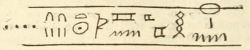
“The earliest date preserved is that of the sixth year of the king’s reign, and he reigned 42 years and some months. The next following dates are, the years 9, 14, 15, 20, 22, 23, 24, 30, 32, 37, 40, 41, and 43; and include, therefore, under this king, a period of 37 years. Of the remaining dates, that only of the 4th year of his two successors is available; all the others, which are on the west or left bank of the river, have been moved from their original place by the rapid floods which have overthrown and carried forward vast masses of rock. One single mark only, that of the 9th year of Amenemha, has been preserved in its original place on one of the building stones, but somewhat below the principal rapid.
“We have now to consider the relation which these—the most ancient of all existing marks of the risings of the Nile—bear to the levels of the river in our own time. We have here presented to us the remarkable facts, that the highest of the records now legible, viz., that of the 30th year of the reign of Amenemha, according to exact measurements which I made, is 8·17 metres (26 feet 8 inches) higher than the highest level to which the Nile rises in years of the greatest floods; and further, that the lowest mark, which is on the east bank, and indicated the 15th year of the same king, is still 4·14 metres (13 feet 6½ inches): and the single mark on the west bank, indicating the 9th year, is 2·77 metres (9 feet) above the same highest level.
“The mean rise of the river, recorded by the marks on the east bank, during the reign of Mœris, is 19·14 metres (62 feet 6 inches) above the lowest level of the water in the present day, which, according to the statements of the most experienced boatmen, does not change from year to year, and therefore represents the actual level of the Nile, independently of its increase by the falls of rain, in the mountains in which its sources are situated. The mean rise above the lowest level, at the present time, is 11·84 metres (38 feet 8 inches); and, therefore, in the time of Mœris, or about 2200 years before Christ, the mean height of the river, at the cataract or rapid of Semne, during the inundation, was 7·30 metres (23 feet 10 inches) above the mean level in the present day.”
Such are the facts recorded by Dr. Lepsius; and then follow, in the same letter, his views as to the cause of the remarkable lowering of the level of the river.
“There is certainly no reason for believing,” he says, “that there has been any diminution in the general volume of water coming from the south. The great change in the level can, therefore, only be accounted for by some changes in the land, and these must also have altered the whole nature of the Nile Valley. There seems to be but one cause for the very considerable lowering of the Nile; namely, the washing out and excavations of the catacombs (Auswaschen und Aushölen der Katakomben[379]); and this is quite possible from the nature of the rocks themselves, which, it is true, are of a quality that could not well be rent asunder, and carried away by the mere force of the water, but might be acted upon directly by the rising of the water-level, and the consequent effects of the sun and air on the places left dry, causing cracks, into which earth and sand would penetrate, which would then give rise to still greater rents, until, at last, the rocks would of themselves fall in, by having been hollowed out, a process that would be hastened in those parts of the hills where softer and earthy beds existed, and which would be more easily washed away. But that, in historical times, within a period of about 4000 years, so great an alteration should take place in the hardest rocks, is a fact of the most remarkable kind—one which may afford ground for many other important considerations.
“The elevation of the water-level at Semne must necessarily have affected all the lands above; and, it is to be presumed, that the level of the province of Dongola was at one time higher, as Semne cannot be the only place in the long tract of cliffs where the bed of rock has been hollowed out. It is to be conceived, therefore, that not only the widely-extended tracts in Dongola, but those of all the higher country in Meröe, and as far up as Fasogle, which, in the present day, are dry and barren on both sides of the river, and are with difficulty irrigated by artificial contrivances, must then have presented a very different aspect, when the Nile overflowed them, and yearly deposited its fertile mud to the limits of the sandy desert.
“Lower Nubia also, between Wadi Halfa and Assuan, is now arid almost throughout its whole extent. The present land of the valley, which is only partly irrigated by water-wheels, is, on an average, from 6 to 12 feet higher than the level to which the Nile now rises; and although the rise at Semne might have no immediate influence upon it, yet what has occurred there makes it more than probable that at Assuan there was formerly a very different level of the river, and that the cataracts there, even in the historical period, have been considerably worn down. The continued impoverishment of Nubia is a proof of this. I have no manner of doubt that the land in this lower part of the valley, which, as already stated, is at present about 10 feet above the highest rise of the Nile, was inundated by it within historical time. Many marks are also met with here, that leave no doubt regarding the condition of the Nile Valley antecedent to history, when the river must have risen much higher; for it has left an alluvial soil in almost all the considerable bays, at an average height of 10 metres (32 feet 9 inches) above the present mean rise of the river. That alluvial soil, since that period, has doubtless been considerably diminished in extent by the action of rain. On the 17th of August Hr. Erbkam and I measured the nearest alluvial hillock in the neighbourhood of Korusko, and found it 6·91 metres (22 feet 7 inches) above the general level of the valley, and 10·26 metres (33 feet 7 inches) above the present mean rise of the river. That rise, which at Semne, on account of the greater confinement of the stream between the rocks, varies as much as 2·40 metres (7 feet 10 inches) in different years, varies at Korusko less than 1 metre (3 feet 3 inches).
“Near Abusimbel, on the west bank, I found the ground of the temple 6·50 metres (21 feet 2 inches) above the highest water-level. This temple, it is well known, was built under Rameses the Great, between 1388 and 1322 years before Christ. Near Ibrîm there are, on the east bank, four grottoes excavated in the vertical rock that bounds the river, which belong partly to the 18th and partly to the 19th Dynasties; the last, under Rameses the Great, is also the lowest, and only 2·50 metres (8 feet 1 inch) above the highest inundation; the next in height is 2·70 metres (8 feet 9½ inches) above the former, and was made 250 years earlier, under Tutmes III. Although I only measured the present level of the valley near Korusko, nevertheless it appears to me that, during the whole of the new kingdom, that is, from about 1700 years before Christ to this time, the Nile has not reached to the full height of the low land of the valley.
“It is, however, conceivable that, at the time when the present low land of the Nubian Valley was formed, the cataracts at Assuan were in a totally different state; one that would, in some degree, justify the overcharged descriptions of the ancients, according to whom they made so great a noise that the dwellers near them became deaf. The damming up of the inundation at Assuan could have no material influence on Egypt, any more than that at Semne, or the land from thence to Assuan.”
It appears, therefore, from the above statements, that at the time mentioned, the Nile, during the inundations, stood 26 feet 8 inches higher than the highest level to which it now rises in years of the greatest floods; and that, to account for this, Professor Lepsius conceives that, between the time of Mœris and the present day, the bed of the Nile, from a considerable distance above Semne to Assuan, must have been worn down to that extent. In the index to the volume of the Berlin Monatsbericht, in which the letters of Professor Lepsius are inserted, there is the following line:—
“Nil, senkung seines Bettes um 25 Fuss seit 4000 Jahren.”
“Nile, sinking of its bed about 25 feet (Paris) within the last 4000 years.”
Rivers are, undoubtedly, among the most active agents of change that are operating on the earth’s surface; the solid matter which renders their waters turbid, and which they unceasingly carry to the sea, afford indisputable proof of this agency. But the power of rivers to abrade and wear down the rocks over which they flow, and to form and deepen their own bed, depends upon a variety of circumstances not always taken into account; and although the great extent of that power, in both respects, is shown in the case of many rivers, to conclude, as some have done, from these instances, that all rivers have excavated the channels in which they flow, is a generalisation that cannot be safely assented to. The excavation of the bed of a river is one of those problems in geological dynamics which can only be rightly solved by each particular case being subjected to the rigorous examination of the mathematician and the physicist. The solid matter which rivers carry forward is in part only the produce of their own abrading power; and the amount of it must be proportional to that power, which is mainly dependent on their velocity; they are the recipients of the waste of the adjoining lands by other combined agencies, and the carriers of it to the lower districts and to the sea. They often afford the strongest evidence of the vast lapse of time that must be included between the beginning and close of a geological period; and, when they flow through countries whose remote political history is known to us, they supply a scale by which we may measure and estimate that lapse of time. This is especially so in the case of the Nile.
When so startling an hypothesis as that now referred to, viz., that the entire bed of so vast a river as the Nile, for more than 250 miles, from Semne to Assuan, has been excavated, within historical time, to a depth of 27 feet, is made by a person whose name carries so much weight in one department of philosophical inquiry, the statement involves such important geological considerations, that it becomes the duty of the geologist to examine, and thoroughly test, the soundness of the explanation, in order that the authority of Professor Lepsius for the accuracy of the facts observed, may not be too readily admitted as conclusive for the correctness of his theory of the cause to which they owe their existence. That there has been such an undoubting admission, appears from the following passage in the work of one of the latest writers on Nubia:
“The translation of the name of this town (Aswán) is ‘the opening;’ and a great opening this once was, before the Nile had changed its character in Ethiopia, and when the more ancient races made this rock (at the first cataract) their watch-tower on the frontier between Egypt and the south. That the Nile has changed its character, south of the first cataract, has been made clear by some recent examinations of the shores and monuments of Nubia. Dr. Lepsius has discovered water-marks so high on the rocks and edifices, and so placed as to compel the conviction that the bed of the Nile has sunk extraordinarily by some great natural process, either of convulsion or wear. The apparent exaggerations of some old writers about the cataracts at Syene may thus be in some measure accounted for. If there really was once a cataract here, instead of the rapids at the present day, there is some excuse for the reports given from hearsay by Cicero and Seneca. Cicero says, that ‘the river throws itself headlong from the loftiest mountains, so that those who live nearest are deprived of the sense of hearing, from the greatness of the noise.’ Seneca’s account is: ‘When some people were stationed there by the Persians, their ears were so stunned with the constant roar, that it was found necessary to remove them to a more quiet place[380].’”
The learned author of an article on Egyptian Chronology and History in the “Prospective Review” for May, 1850, in referring to the contributions of Professor Lepsius to Egyptian history, says: “He has discovered undescribed pyramids, equal in number to those known before; has traced the Labyrinth, and ascertained its founder. He has detected inscriptions on the banks of the Nile, which show that its bed has subsided many feet in historic times.” 9th June, 1850.
In the assumption of an excavation of the bed of the river, we have no small amount of wear to deal with, for the distance from Semne to Assuan, following the course of the river, is not less than 250 miles; and if, as Professor Lepsius supposes, the excavation extended to Meröe, we have a distance, between that place and Assuan, of not less than 600 miles.
Although these records of a former high level of the Nile at Semne had not been noticed by any traveller prior to Professor Lepsius, we may rest fully assured of the accuracy of his statements, from the habitual care and diligence, and the established character for fidelity, of the observer. The silence of other travellers may be readily accounted for by this, that none of them appear to have remained more than a very short time at this spot—not even the diligent Russegger—whereas we have seen that Professor Lepsius passed twelve days in the examination of this gorge in the Nile Valley.
The theory of a lowering of the bed of the river by wearing, involves two main considerations, viz., the power of the stream, and the degree of hardness of the rocks acted upon. The power depends upon the volume and velocity of the river—the velocity on its depth, and the degree of inclination of the bed: the hardness of the rocks we can form a tolerable estimate of when we know their nature. To judge, therefore, of the probability of the hypothesis of Professor Lepsius, we must inquire into the physical and geological features of the Nile Valley, in Nubia.
In the observations I have now to offer, my information has been derived of course entirely from the works of other travellers, particularly those of Burckhardt, Rüppell, and Russegger[381], and especially the latter, who travelled in Nubia in 1837; for he not only enters far more into the details of the natural history of the country, but he is the only traveller in Nubia who appears, from previous acquirements, to have been competent to describe its natural history with any degree of accuracy—I refer more particularly to the physical and geological features of the country. Besides full descriptions in his volumes, he has given a geological map of Nubia, and also several sections, or what may more properly be called vertical sketches—a term that would, perhaps, be a more appropriate designation for all sections that are not drawn to a true scale, or at least when the proportion of height to horizontal distance is not stated.
The Physical Geography of Lower Nubia[382].
Russegger informs us[383], that he believes he was the first traveller who had succeeded in making a series of barometrical measurements along the Nile Valley, from the Mediterranean to Sennaar and Kordofan, and thence to the 10th degree of north latitude. He gives the following altitudes, above the sea:
Paris Feet. English Feet.
The upper part of the Cataract of Assuan 342 = 364·37
Korusko, on the right bank of the Nile, in Nubia 450 = 479·43
Wadi Halfa 490 = 522·00
New Dongola 757 = 806·52
Abu Hammed 963 = 1026·00
I shall now give the length of the Nile along its course from Abu Hammed to the island of Philæ, at the head of the cataract of Assuan. I employ for this purpose the map in the atlas which accompanies the work of Russegger, which bears the date of 1846, and which, doubtless, was constructed on the best authorities. He mentions a map of General von Prokesch with great praise[384]. It flows:
German M. English M.
From NE. to SW., from Abu Hammed to Meröe, about 31 = 150
It makes a curve between Meröe and Old Dongola, of about 16 = 77
It flows between Old and New Dongola, from SE. to NW., about 16 = 77
Then, with some short windings, nearly due north to the island of Sais, for about 30 = 145
And from Sais to the island of Philæ, from SW. to NE., about 68 = 327
Making the whole length of the course, from Abu Hammed to Philæ, about 161 = 776
Ascending the river, we have, between Philæ and Korusko, a distance of 24 German, or 115½ English miles, and without any rapid, except one near Kalabsche. Korusko being 115 feet above the head of the cataract of Assuan, at Philæ, we have an average fall of the river between these two places of a foot in a mile.
Between Korusko and Wadi Halfa there is no rapid. The distance being 20 German, or 96⅓ English miles, and the difference of altitude being 42½ feet, we have an average fall throughout that part of the river’s course of not more than 5·3 inches in a mile.
This very inconsiderable fall need not surprise us; for the average fall of the Nile in Lower Egypt, at the lowest water, is little more than one-third of that now stated. At the time of the highest water the surface of the Nile, at Boulak, near Cairo—that is, about 116 miles in a direct line from the coast—is only 43·437 English feet above the level of the Mediterranean, and at the time of the lowest water, only 17·33 feet. Thus, in the first case, there is an average fall of about 5·00 inches; in the second, of not more than 1·80 inches in a mile[385].
Between Wadi Halfa and Dale, a distance of about 94 miles, six cataracts, or schellals, as they are called in the language of the country, are marked in Russegger’s map. And here, it may be as well to notice, that there are no cataracts, in the ordinary sense of the term, on the Nile; no fall of the river over a precipice; all the so-called cataracts are rapids, where the river rushes through rocks in its bed; the rapids varying in their length and degrees of inclination. We have no measurements of their lengths or of their falls, except as regards the first and second cataracts. The former, according to Russegger, has a fall of about 85 English feet in a distance of about 8 miles; and he describes the latter as extending from 5 to 6 stunden; that is, from 12 to 14½ miles, but he does not give the height. Speaking of the schellals above Semne, Russegger says, that all may be passed in boats without difficulty for about six weeks, or two months in the year. This is the case also at the cataract or rapid of Assuan. But between Wadi Halfa and Dale, with some inconsiderable spaces of free navigable water, in the ordinary state of the river, there is an almost uninterrupted series of rapids. We have no measurement of the height of Dale above Wadi Halfa, near to which the second great cataract of the Nile occurs; but this is the part of the river’s course where the fall is greatest, and from Semne to Dale there are about 45 miles of this more rapid fall.
From Dale to New Dongola, a distance of 35 German, or about 168 English miles, only three rapids are marked on Russegger’s map—the highest being at Hannek, about 26 English miles below New Dongola. New Dongola being 806 English feet above the sea, and the distance from that place to the rapid of Hannek being 26 miles only, we may with probability estimate the surface of the river at the rapid of Hannek at 780 feet above the sea. Now, Wadi Halfa being 522 feet, we have a difference of height, between these two last-named places, of 258 feet; and the length of the river’s course between them being 236 miles, we have an average fall of 13·12 inches in a mile; that is, in the part of the river’s course where nine rapids occur, in the provinces of Batn-el-Hadjar, Sukkôt, and Dar-el-Mahass, where the river flows over granite and other plutonic rocks; gneiss, mica-schist, and other hard rocks, which Russegger considers to be metamorphic. But between Semne and the head of the second cataract at Wadi Halfa, there is not a continuous rapid stream; for Hoskins says, that about two miles above that cataract, the river has a width of a third of a mile, and, when he passed it, the water was scarcely ruffled[386].
From the rapid of Hannek to Abu Hammed the distance is 329 English miles, and the difference of altitude is 246 English feet. We have thus an average fall in that distance of 9·00 inches in a mile.
Thus, in the 776 miles between Abu Hammed and Philæ, we have an average fall of the Nile
Of 9·00 inches in a mile, for a distance of 329 miles.
Of 13·12 ” ” 236 ”
Of 5·30 ” ” 96 ”
Of 12·00 ” ” 115 ”
Of the Breadth, Depth, and Velocity of the Nile, in Nubia.
Our information is very scanty respecting the breadth and depth of the river, either at the time of lowest water or during the inundations. About two miles above Philæ, it is stated by Jomard[387] to be 3000 metres, or nearly two English miles wide. At the second cataract, or rapid of Wadi Halfa, it spreads over a rocky bed of nearly two miles and a quarter in width (2000 klafter)[388], but contracts above the rapid to a third of a mile. Russegger also states, that the Nile, near Boulak, in Lower Egypt, is 2000 toises, nearly two-and-a-half English miles in breadth, and yet that it is considerably wider in some parts of Southern Nubia; but Burckhardt says that the bed of the Nile in Nubia is, in general, much narrower than in any part of Egypt. Near Kalabsche, about 30 miles above Philæ, the river runs through a gorge not more than 300 paces wide, and its bed is full of granite blocks. It shortly afterwards again widens for some distance; but near Sialla, 78 miles above Philæ, it is contracted by the sandstone hills on both sides coming so near each other, that the river’s bed is again not more than from 250 to 300 paces wide. It is about 600 yards broad about two miles above the second cataract near Wadi Halfa, but is again very much contracted in the rocky region of Batn-el-Hadjar. At Aulike it is only 200 paces broad[389].
I have not met with any measurements of the depth of the river in any part of its course in Nubia; but Hoskins describes it as being so shallow at the island of Sais, 327 miles above Philæ, on the 9th of June, which would be before the commencement of the inundation, as only to reach the knees of the camels[390]. Near Derr, about 86 miles below the Cataract of Wadi Halfa, Norden, in January, found the river so shallow that loaded camels waded through it, and his boat frequently struck the ground. In May, Burckhardt found the river fordable at Kostamne, 53 miles above Philæ; and Parthey states, that between Philæ and the island of Bageh, to the west of it, the river is so shallow before the commencement of the inundation, that it may be waded through[391]. Burckhardt says, that from March to June the Nile-water, in Nubia, is quite limpid[392]. Miss Martineau, who visited Nubia in December and January, speaking of the river above Philæ, says, that it “was divided into streamlets and ponds by the black islets. Where it was overshadowed it was dark-grey or deep blue, but when the light caught it rushing between a wooded island and the shore, it was of the clearest green[393].” At the second cataract she describes the river as “dashing and driving among its thousand islets, and then gathering its thousand currents into one, proceeds calmly in its course[394].”
Although we have no accurate measurements of the velocity of the Nile in Nubia, we may arrive at an approximate estimate of it by comparing its fall with that of a river well known to us.
I have stated the fall of the Nile in different parts of its course to be 5·30, 9·00, 12·00, and 13·12 inches in a mile. The fall of the Thames from Wallingford to Teddington Lock, where the influence of the tide ends, is as follows:
Length of Course. Fall. Fall in Inches per Mile.
Miles. F. Feet. in.
From Wallingford to Reading Bridge 18·0 24·1 15·72
From Reading to Henley Bridge 9·0 19·3 25·68
From Henley to Marlow Bridge 9·0 12·2 16·20
From Marlow to Maidenhead Bridge 8·0 15·1 22·32
From Maidenhead to Windsor Bridge 7·0 13·6 23·16
From Windsor to Staines Bridge 8·0 15·8 23·52
From Staines to Chertsey Bridge 4·6 6·6 17·28
From Chertsey to Teddington Lock 13·6 19·8 17·40
77·4 125·11
“In general, the velocity may be estimated at from half a mile to two miles and three-quarters per hour; but the mean velocity may be reckoned at two miles per hour. In the year 1794, the late Mr. Rennie found the velocity of the Thames at Windsor two miles and a half per hour[395].”
It will thus be seen that the velocity of the Nile is probably greatly inferior to that of the Thames; for it appears that, except during the inundation, for more than half the year the depth is inconsiderable. The average fall when greatest, that is, including the province of Batn-el-Hadjar, where the rapids chiefly occur, is considerably less than that of any part of the above course of the Thames; so that there must be long intervals between the rapids where the fall must be far less than 13 inches in a mile. The breadth of the Nile is vastly greater; but supposing the depth of the water to be the same as that of the Thames, on account of the friction of the bed, the greater breadth would add very little to the velocity. If we assume the average depth of the Thames in the above distance to be 5 feet, and that it flows with an average velocity of 2 miles in an hour, and if we assume the average depth of the Nile in that part of its course where the fall is 13·12 inches to be 10 feet, when not swollen by the rise, the velocity would be 2⅘ miles nearly in an hour[396], if the fall were equal to that of the Thames. We shall probably come near the truth, by assuming the velocity of the Nile on this part at 2 miles in an hour. That it must be considerably less in the other divisions of the course I have named, and especially in that part immediately below the second cataract, where the average fall is only 5·30 inches for a distance of 96 miles, is quite evident.
The power of a river to abrade the soil over which it flows, so far as water is by itself capable of doing so, must depend upon its volume and velocity, and the degree of hardness of the material acted upon. The power is increased when the water has force enough to transport hard substances. But even transported gravel has little action on the rocks with which it comes in contact, when it is free to move in running water, unless the fall be considerable, and, consequently, the velocity and force of the stream great. When stones are firmly set in moving ice, they then acquire a great erosive power, cutting and wearing down the rocks they are forcibly rubbed against; but this condition never obtains in Lower Nubia, as ice is unknown there.
Geological Structure of Lower Nubia.
One kind only of regularly stratified rock occurs in the 776 miles from Abu Hammed to Philæ; viz., a silicious sandstone, similar to that which occurs to a great extent on both sides of the Nile in Upper Egypt, and which Russegger, after a very careful examination of it there, considers to be an equivalent of the greensand of the cretaceous rocks of Europe. The tertiary nummulite limestone, so abundant in Egypt, has not hitherto been met with in Nubia.
The Nile flows over this sandstone for nearly 426 miles of the entire distance, but not continuously. At Abu Hammed, it flows over granitic rocks, and these continue from that place for about 120 miles. There is then about 215 miles of the sandstone, which is succeeded by igneous and metamorphic rocks, that continue for 195 miles without any interruption, except a narrow stripe of sandstone of about 15 miles near Amara. It is in this region of hard igneous rocks that nearly all the rapids occur, between that of Hannek and the great or second cataract at Wadi Halfa. From the latter place there is sandstone throughout a distance of about 196 miles, and then commences the granitic region of the Cataract of Assuan, through which the Nile flows about 35 miles. Thus we have about 350 miles of igneous and metamorphic rocks, and about 426 of sandstone.
The general hard nature of the igneous and metamorphic rocks, over which the Nile flows for about 155 miles above Semne, and for about 40 immediately below it, will be recognised by my naming some of the varieties described by Russegger, viz., granites of various kinds, often penetrated by greenstone dykes; sienite, diorite, and felspar porphyries; gneiss, and clay slate, penetrated by numerous quartz veins.
The siliceous sandstone is very uniform in its character; and in Nubia, as in Egypt, the only organic bodies which it has as yet been found to contain, are silicified stems of wood. Occasionally, as in the neighbourhood of Korusko, interstratified beds of marly clay are met with[397].
When, therefore, we take into account the hard nature of the siliceous sandstone, the durability of which is shown by the very ancient monuments of Egypt and Nubia, that are formed of it, and the still greater hardness of the granites and other crystalline rocks, it is manifest that the wearing action of a river flowing over so gentle a fall, can scarcely be appreciable. If the occasional beds of marly clay occur in the bank of the river, they may be washed out, and blocks of the superincumbent sandstones may fall down; but such an operation would have a tendency to raise rather than deepen the bed of the river at those places; unless the transporting power of the stream were far greater than can exist with so moderate a fall, especially in that part of the river below Semne, where, for 96 miles, it is not more than 5·3 inches, and for 115 miles below that, not more than 12 inches in a mile. Even if we suppose the river to have power to tear up its bed for some distance above Semne and below it, as far as the rapid of Wadi Halfa, it is evident that the materials brought down would be deposited, except the finest particles, in that tranquil run of 96 miles, which may be almost compared to a canal. The drains in Lincolnshire are inclined 5 inches to a mile[398]. When the annual inundations commence, the water of the Nile comes down the rapid at Assuan of a reddish colour loaded with sand and mud only; whatever detrital matter of a larger and heavier kind the Nile may have brought with it, is deposited before it reaches that point.
From all these considerations, therefore, I come to the conclusion, that the bed of the Nile cannot have been excavated, as Professor Lepsius supposes, since the date of the sculptured marks on the rock at Semne. He says, “Es lässt sich kaum eine andere Ursache für das bedeutende Fallen des Nils denken, als ein Auswaschen und Aushölen der Katakomben.” By the word Katakomben[399] he can only mean natural caverns in the rock; but such caverns are rarely, if ever, met with in sandstones, and only occasionally in limestones. If the course of the Nile were over limestone instead of sandstone, we could not for a moment entertain the idea of a succession of caverns for 200 miles beneath its bed, sometimes two miles in width, the roofs of which were to fall in; and where the igneous rocks prevail, this explanation is wholly inapplicable.
But besides the objections arising from the nature of the rocks, and the inconsiderable fall of the river, there is still another difficulty to overcome. It is to be borne in mind, that this lowering of the bed of the Nile, from Semne to Assuan, is supposed to have taken place within the last 4000 years. Between the first cataract at Assuan and the second at Wadi Halfa there are numerous remains of temples on both banks of the Nile, some of very great antiquity. “From Wadi Halfa to Philæ,” says Parthey, “there is a vast number of Egyptian monuments, almost all on the left bank of the river, and so near the water that most of them are in immediate contact with it[400].” We may rest assured that the builders of these would place them out of the reach of the highest inundations then known. Although we have many accurate descriptions of these monuments, the heights of their foundations above the surface of the river are not often given; they are, however, mentioned in some instances. I shall describe the situations of some of these buildings relatively to the present state of the river’s levels, and shall begin with those on the island of Philæ.
This island, according to the measurements of General von Prokesch, is 1200 Paris feet (1278 English) in length, and 420 (447) in breadth, and is composed of granite. Lancret informs us, that, “à l’époque des hautes eaux, l’île de Philæ est peu élevée au-dessus de leur surface: mais, lorsqu’elles sont abaissées, elle les surpasse de huit mètres.” It was formerly surrounded by a quay of masonry, portions of which may be traced at intervals, and in some places they are still in good preservation. The south-west part of the island is occupied by temples. According to Wilkinson, the principal building is a temple of Isis commenced by Ptolemy Philadelphus, who reigned from 283 to 247 years before Christ; and he adds, that it is evident an ancient building formerly stood on the site of the present great temple. Lancret, in referring to this more ancient building, says:—“Il y a des preuves certaines d’une antiquité bien plus reculée encore, puisque des pierres qui entrent dans la construction de ce même grand temple, sont des débris de quelque construction antérieure.” Rosellini considers that it was built by Nectanebus. The first king of Egypt, of the Sebennite Dynasty of that name, ascended the throne 374 years B.C., the second and last ceased to reign about 350 years B.C.[401]
Rosellini[402] informs us, that on the island of Bageh, opposite to Philæ, there are the remains of a temple of the time of Amenophis II., and a sitting statue of granite representing him. He was a king in the earlier years of the 18th Dynasty, which, according to the Chevalier Bunsen[403], began in the year 1638, and ended in 1410 B.C.
Gau[404], in describing a temple at Debu, about 12 miles above Philæ, which he visited in January, and consequently during the time of low water, states that he discovered under the sand, at the edge of the river, the remains of a terrace leading towards a temple.
A short distance north of Kalabsche, about 30 miles above Philæ, at Beil-nalli, Rosellini[405] speaks of a small temple in the following terms:—“Among the many memorials that still exist of Ramses II., the most important, in a historical point of view, is a small temple or grotto excavated in the rock!” and Wilkinson mentions it “as a small but interesting temple excavated in the rock, of the time of Ramses II., whom Champollion supposes to be the father of Sesostris or Rameses the Great[406].” He was the first king of the 19th Dynasty, which began in the year 1409 B.C.[407]
Gau[408] thus describes a monument at Gerbé Dandour:—“La chaîne de montagnes qui borde le Nil est, dans cet endroit, si approchée du lit de ce fleuve, qu’il ne reste que très peu d’espace sur la rive. Cet espace est presque entièrement occupé par le monument, et la rivière, dans ses débordemens, arrive jusqu’au pied du mur de la terrasse.”
Parthey informs us that the temple of Sebûa is about 200 feet distant from the river, in which distance there are two rows of sphinxes, and that the road between them, from the temple, ends in wide steps at the water’s edge; and he adds that Champollion refers this temple to the time of Rameses the Great[409].
It thus appears that monuments exist close to the river, some of which were constructed at least 1400 years before our era; so that taking the time of Amenemha III. to be, as Professor Lepsius states, 2200 years B.C., the excavation of the bed of the Nile which he supposes to have taken place, must have been the work, not of 4000 years but of 800. If the erosive power of the river was so active in that time, it cannot be supposed that it then ceased; it would surely have continued to deepen the bed during the following 3000 years.
At all events, the buildings on the island of Philæ demonstrate that the bed of the Nile must have been very much the same as it is now, 2200 years ago; and even a thousand years earlier it must have been the same, if the foundation of the temple on the island of Bageh, opposite to Philæ, be near the limit of the highest rise of the Nile of the present time; so that there could be no barrier at the Cataract of Assuan to dam up the Nile when they were constructed; and thus the deafening sound of the waterfall recorded by Cicero and Seneca must still be held to be an exaggeration.
The existence of alluvial soil, apparently of the same kind as that deposited by the Nile, in situations above the Cataract of Assuan, at a level considerably above the highest point which the inundations of the river have reached in modern times, to which allusion is made by Professor Lepsius, has been noticed by other travellers, and even at still higher levels than those he mentions. Whether that alluvial soil be identical with, or only resembles the Nile deposit, would require to be determined by a close examination, and especially with regard to organic remains, if any can be found in it. There is no evidence to show that it was deposited during the historical period, and it may be an evidence of a depression and subsequent elevation of the land antecedent to that period. It may not be of fresh-water origin, but the clay and sand, or till, left by a drift while the land was under the sea. For remote as is the antiquity of Nubia and Egypt, in relation to the existence of the human race, it appears to be of very modern formation in geological time. The greater part of Lower Egypt, probably all the Delta, is of post-pliocene age, and even late in that age; and the very granite of the Cataract of Assuan, that of which the oldest monuments in Egypt are formed, and which, in the earlier days of geology, was looked upon as the very type of the rock on which the oldest strata of the earth were founded, is said to have burst forth during the later tertiary period. We learn from Russegger, that the low land which lies between the Mediterranean and the range of hills that extends from Cairo to the Red Sea at Suez, and of which hills a nummulite limestone constitutes a great part, is composed of a sandstone which he calls a “Meeresdiluvium,” a marine diluvial formation, and considers to be of an age younger than that of the sub-appennines[410]. This sandstone he found associated with the granite above Assuan, and covering the cretaceous sandstone far into Nubia. It appears, therefore, that, in the later ages of the tertiary period, this north-eastern part of Africa must have been submerged, and that very energetic plutonic action was going forward in the then bed of the sea. The remarkable fact of the granite bursting through this modern sandstone is thus described by Russegger:
“We arrived at a plateau of the Arabian Chain south-east of Assuan. It is about 200 feet above the bed of the Nile, and consists of the lower and upper sandstone, which are penetrated by innumerable granite cones from 20 to 100 feet in height, arranged over the plateau in parallel lines, very much resembling volcanic cones rising from a great cleft. The sandstone is totally altered in texture near the granite, and has all the appearance as if it had been exposed to a great heat. ‘I cannot refrain,’ he says, ‘from supposing that the granite must have burst, like a volcanic product, through long wide rents in the sandstone, and that, in this way, the conical hills were formed[411].’”
An eruption of a true granite during the period of the sub-appennine formations, one possessing the same mineral structure as that we know to have been erupted during the period of the palæozoic rocks, would be a fact of so extraordinary a kind, that its age would require to be established on the clearest evidence, and especially by that of organic remains in the sandstone.
Having thus ventured—I trust without any want of the respect due to so eminent a person—to reject the hypothesis proposed by Professor Lepsius for the high levels of the Nile at Semne, indicated by the sculptured marks he discovered, it may perhaps be expected that I should offer another more probable explanation. If in some narrow gorge of the river below Semne, a place had been described by any traveller, where, from the nature of the banks, a great landslip, or even an artificial dam, could have raised the bed to an adequate height; that is, proportionate to the fall of the river, as it was more distant from Semne, a bar that, in the course of a few centuries, might have been gradually washed away, I might have ventured to suggest such a solution of the problem. But without any information of the existence of such a contraction of the river’s channel, or any exact knowledge of the natural outlets and dams to running water along the 250 miles of the Nile Valley, from Semne to Assuan, it would be idle to offer even a conjecture. These marks are unquestionably very difficult to account for, in the present imperfect state of our knowledge of the structure of that portion of the Nile Valley; and any competent geologist, well versed in the questions of physical structure involved, who may hereafter visit Nubia, would have a very interesting occupation in endeavouring to solve the difficulty.
7th April, 1850.
Translation of a Letter from Dr. Lepsius to Mr. Horner, dated Berlin the 12th of April, 1853.
Dear Sir,—I observe from a letter of your daughter, that she is desirous of adding to her translation of my Letters a note upon the height of the water of the Nile, with reference to your paper in the “Edinburgh Philosophical Journal.” I wish that you would get reprinted in that note the whole of the small memoir, as it possesses great interest, and abounds in data not easily brought together; for in that case the subject may probably be further discussed.
I will, at all events, avail myself of this opportunity to make some remarks, which you may, if you like, propose to have introduced into the contemplated note.
I must first remark that the word Katakomben was entirely a typographical error for Katarakten, as was unfortunately the case in many other instances in those things which were printed during my absence.
But in respect of the explanation of the observed facts, my views are perhaps less different from yours than you imagine. You imagine a natural or artificial barrier which has broken down, but this appears to me of insufficient magnitude; I too imagine barriers to have existed, and natural ones, but that there must have been several of them. I do not, moreover, regard it as impossible, that at certain periods, when the country was in its most flourishing condition, artificial dams may have been constructed in order to obtain a higher rise of the water within a particular space, such as was necessary for an overflowing. But if we imagine an entire dam thrown across the river, this, if I am not mistaken, could only hold back the current for a very short way, namely, where there is a greater general fall. If, for example, we imagine a barrier at Assuan, it would require to be several hundred feet high to have any effect on the height of the water at Semneh, and then the whole valley from Philæ to Wadi Halfa would be a great lake, as it may indeed have been in geological time.
If we imagine a succession of barriers which would be especially formed where veins existed in the primitive rock, then the present entire physiognomy of the Nile valley seems to be more easily explained. The river-bed, amidst granitic or other upheaved rock, is not level, like a chalk or sandstone channel, but forms sometimes lakes, sometimes barriers. The force of the swollen current at these last, of which there is one at Semneh itself, does not act in the mean proportion of a space of considerable extent, but with immense effects, exceeding all calculation, especially when, in addition, there is a contraction of the sides, as at Semneh. Immediately below this barrier the bed again spreads out, and the rocks disappear in the current. The colossal rock-fragments on that bank, whose inscriptions sometimes show that above 4000 years ago they were still not broken loose, display the Titan force of a current thus hemmed in, and allow us to conceive how at that spot it gradually washed out its bed, sometimes to a great depth, but sometimes also to a greater breadth, which has the same effect, and how all that is broken away, or that during the time of low water splits to a considerable depth in the bed of the river from the summer heat, rolls away, until arrested by falling into hollows. But if these single barriers are only washed away in the course of thousands of years, then the whole river must receive an equable fall, and it will never rise in the very rocky districts, but can only continue to be still more excavated, and will only again deposit the heavier portions it bears along with it, below the cataracts, where every obstruction disappears. The monuments can hardly be cited in opposition to the view of a gradual sinking of the bed of the river in the higher districts. All of them lie tolerably far above the region of the rise of the Nile—for example, the temple on the island of Bigeh, to which there is a considerable ascent. Philæ has only been built upon since the time of Nectanebus, and there is nothing to indicate buildings of an earlier date. The sinking of the surface of the water even at Philæ and Assuan must also have been far less than at Semneh. Nevertheless, special researches with respect to the relative condition of the ancient temple and rock-inscriptions to the present surface of the water would certainly be of the greatest utility.
Herr von Humboldt, after reading some observations on the same subject by Wilkinson in the Nouv. Ann. des Voyages, i., without recollecting my views, wrote to me as follows:
“Breaches in dams, I imagine, cause only temporary rises of water, unless in earlier times (for which I see no reason) there was a greater accumulation of water in the valley of the river, from meteorological causes. Primeval conditions, where broad valleys were filled with waters, are not applicable to periods when there were inscriptions. Does it not seem to you more probable, that the height of the water was at one time at a greater elevation, on account of the bed of the river not having been so much furrowed out, because at an earlier period the bottom of the river was not at c d, but at e f.
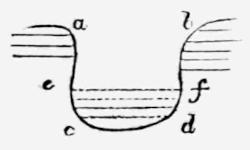
“There are rivers whose beds are elevated and rendered more shallow by deposition, others which furrow out their bed qui creusent un lit plus profond.”
With sincere respect, your faithful,
R. Lepsius.
Appendix B. (P. 303 and 318.)—The tradition of Gebel Mûsa being the Mount of the Law, became gradually more decided and exclusive for this view after the time of Procopius in the sixth century; mainly, no doubt, on account of the church founded at that spot in the reign of Justinian. I am not aware that there are any modern travellers and savants who have thrown doubts on the correctness of this assumption. Not even Burckhardt, although from the numerous inscriptions on Serbâl he was led to infer that that mountain might have been at one time incorrectly regarded by the pilgrims as Sinai. The words of this distinguished traveller are as follows: (Trav. in Syr. p. 609.) “It will be recollected that no inscriptions are found either on the Mountain of Moses, or on Mount St. Catherine; and that those which are found in the Ledja valley at the foot of Djebel Catherine, are not to be traced above the rock from which the water is said to have issued, and appear only to be the work of pilgrims who visited that rock. From these circumstances I am persuaded that Mount Serbâl was at one period the chief place of pilgrimage in the Peninsula; and that it was then considered the mountain where Moses received the tables of the law; though I am equally convinced, from a perusal of the Scriptures, that the Israelites encamped in the Upper Sinai, and that either Djebel Mousa, or Mount St. Catherine, is the real Horeb. It is not at all impossible that the proximity of Serbâl to Egypt, may at one period have caused that mountain to be the Horeb of the pilgrims, and that the establishment of the convent in its present situation, which was probably chosen from motives of security, may have led to the transferring of that honour to Djebel Mousa. At present neither the monks of Mount Sinai nor those of Cairo consider Mount Serbâl as the scene of any of the events of sacred history; nor have the Bedouins any tradition among them respecting it, but it is possible, that if the Byzantine writers were thoroughly examined, some mention might be found of this mountain, which I believe was never before visited by any European traveller.”
More recently the remarkable book of travels by E. Robinson form a marked epoch in our knowledge of the Peninsula as well as of Palestine. With reference to the position of Sinai, he for the first time especially urges the favourable vicinity of the great plain of Râha, to the north of Gebel Mûsa, in which there was ample space for the encampment of the people of Israel. (Palestine, vol. i., p. 144, &c.) In his determination, however, of the actual Mount of the Law, he deviates from the previous tradition, since he endeavours to prove that Moses did not ascend Gebel Mûsa, but the mountain ridge jutting out from the south, above the plain, which is now called Horeb by the monks, and whose highest point is named Sefsâf. (Vol. i. p. 176.) Unfortunately he did not visit Wadi Firân and the adjoining Serbâl. In a more recent treatise (Bibl. sacra. vol. iv. No. xxii. May, 1849, p. 381, &c.) the learned author returns to the question with reference to my view of it, with which he had become acquainted, and in opposition he especially mentions the arguments which he had formerly maintained in favour of Gebel Sefsâf. He comprehends these under the three following heads, which he extracts from the Mosaic narrative, as being eminently striking, and which must therefore also now be pointed out: “1st. A mountain summit overlooking the place where the people stood. 2nd. Space sufficient adjacent to the mountain for so large a multitude to stand and behold the phenomena on the summit. 3rd. The relation between this space where the people stood and the base of the mountain must be such that they could approach and stand at ‘the nether part of the mount,’ that they could also touch it; and that further bounds could appropriately be set around the mount, lest they should go up into it, or touch the border of it.” Of these three heads, the first would speak against Gebel Mûsa, and not against Serbâl. This last, says Robinson, is excluded by the second and third head. Now with respect to the second, I must only call to mind that the encampment of the people at Sinai is not related in a different manner from all the previous stations. If, therefore, we take such a circumscribed view of the encampment as to believe that we must provide for sufficient space for the settlement of such a great people, we should then have to indicate a plain of Râha at all the previous stations, especially in Raphidîm (which by almost unanimous opinion was situated at the foot of the Serbâl), because here manifestly they remained for a considerable time, Moses was visited by Jethro, by his advice divided the whole people into tens, and organised them according to a form of law, from which we should be compelled to conclude that there, for the first time, existed a distinct locality for each individual. He who imagines a multitude of two millions of men, about as many as the inhabitants of London, or of the whole of Egypt at the present day, placed in an enclosed camp composed of tents, of which they must have had two hundred thousand, if we reckon one for every ten, like a huge, well-arranged military camp, even to him the plain of Râha would appear too small; but he who assumes that a comparatively small number could assemble round the chief quarters of Moses, but that all the others must have sought for shady places, caves in the rock-precipices, and the scanty herbage of the adjacent valleys, can as easily imagine the camp to have been placed in Wadi Firân, or at any other station. Wadi Firân besides, as far down as El Hessue, even if we only take its most fertile portion (more inviting as a settlement than any other spot), would offer, in combination with the broad Wadi Aleyât, just as large, and at all events a far more habitable space, for a combined encampment than the plain of Râha. Indeed, if it be true that we can gain anything from such single facts, such an encampment would render it still more comprehensible why the people were led out of the camp towards God at the foot of the mountain in the upper portion of Wadi Aleyât, in order to have a complete survey of the mountain. To obtain such a view would be impossible at Gebel Mûsa, and unnecessary at Gebel Sefsâf. Finally, the command not to ascend the mountain, which is expressed still more imperatively, that no one “should touch the border of the mountain,” applies to every mountain, which rises simply before the eyes, and whose means of access can be shut out by a fence. Immediately beyond the fence lies the border of the mountain.
With reference to this last point, Robinson appeals to my own map of Serbâl, and the description of Wadi Aleyât, by Bartlett (Forty Days in the Desert, p. 54, 59). It would be difficult, however, to prove from my map that the people could not have spread themselves out at the foot of the mountain, and Bartlett seems to me rather to share my opinion. As this traveller is so well known by his descriptions of countries, which are both beautifully illustrated and clearly and graphically described, and as he is just one of the few who have examined the localities with his own eyes in reference to the question started by me without holding any previous views on the subject, it may not be inappropriate to insert here those words relating to it, from a book cited by Robinson in favour of his own view; so much the rather, as I could not possibly have placed the chief heads of the question in a more convincing point of view.
He says, p. 55[412]: “If we endeavour to reconcile ourselves to the received but questionable system which seeks to accommodate the miraculous with the natural, it is impossible, I think, not to close with the reasoning advanced in favour of the Serbâl. There can be no doubt that Moses was personally well acquainted with the Peninsula, and had even probably dwelt in the vicinity of Wadi Feirân during his banishment from Egypt; but even common report as to the present day, would point to this favoured locality as the only fit spot in the whole range of the desert for the supply, either with water or such provisions as the country afforded, of the Israelitish host: on this ground alone, then, he would be led irresistibly to fix upon it, when meditating a long sojourn for the purpose of compiling the law. This consideration derives additional force when we consider the supply of wood and other articles requisite for the construction of the tabernacles, and which can only be found readily at Wadi Feirân, and of its being also, in all probability, from early times a place visited by trading caravans. But if Moses were even unacquainted previously with the resources of the place, he must have passed it on his way from the sea-coast through the interior of the mountains, and it is inconceivable that he should have refused to avail himself of its singular advantages for his purpose, or that the host would have consented, without a murmur, to quit, after so much privation, this fertile and well-watered oasis for new perils in the barren desert, or that he should, humanly speaking, have been able either to compel them to do so, or afterwards to fix them in the inhospitable, unsheltered position of the monkish Mount Sinai, with the fertile Feirân but one day’s long march in their rear. Supplies of wood, and perhaps of water, must, in that case, have been brought of necessity from the very spot they had but just abandoned. We must suppose that the Amalekites would oppose the onward march of the Israelites, where they alone had a fertile territory worthy of being disputed, and from which Moses must, of necessity, have sought to expel them. If it be so, then in this vicinity, and no other, we must look for Raphidîm, from whence the Mount of God was at a very short distance. We seem thus to have a combination of circumstances, which are met with nowhere else, to certify that it was here that Moses halted for the great work he had in view, and that the scene of the law-giving is here before our eyes in its wild and lonely majesty. The principal objection to this is on the following ground, that there is no open space in the immediate neighbourhood of the Serbâl suitable for the encampment of the vast multitude, and from which they could all of them at once have had a view of the mountain, as is the case at the plain Er Rahah at Mount Sinai, where Robinson supposes, principally for that reason, the law to have been given. But is this objection conclusive? We read, indeed, that Israel ‘camped before the mount,’ and that ‘the Lord came down in sight of all the people;’ moreover, that bounds were set to prevent the people from breaking through and violating even the precincts of the holy solitude. Although these conditions are more literally fulfilled at Er Rahah, yet, if we understand them as couched in general terms, they apply perhaps well enough to the vicinity of the Serbâl. A glance at the view, and a reference to this small rough map[413], will show the reader that the main encampment of the host must have been in Wadi Feirân itself, from which the summit of the Serbâl is only here and there visible, and that it is by the lateral Wadi Aleyât that the base of the mountain itself, by a walk of about an hour, is to be reached. It certainly struck me, in passing up this valley, as a very unfit, if not impracticable spot for the encampment of any great number of people, if they were all in tents; though well supplied with pure water, the ground is rugged and rocky—towards the base of the mountain awfully so; but still it is quite possible that a certain number might have established themselves there, as the Arabs do at present, while, as on other occasions, the principal masses were distributed in the surrounding valleys. I do not know that there is any adequate ground for believing, as Robinson does, that because the people were warned not to invade the seclusion of the mount, and a guard was placed to prevent them from doing so, that Therefore the encampment itself pressed closely on its borders. Curiosity might possibly enough lead many to attempt this even from a distance, to say nothing of those already supposed to be located in the Wadi Aleyât, near the base of the mountain, to whom the injunction would more especially apply. Those, however, who press closely the literal sense of one or two passages, should bear in mind all the difficulties previously cited, and the absolute destitution of verdure, cultivation, running streams, and even of abundant springs, which characterise the fearfully barren vicinity of the monkish Sinai, where there is indeed room and verge enough for encampment, but no resources whatever. If we take up the ground of a continual and miraculous provision for all the wants of two millions of people, doubtless they may have been subsisted there as well as in any other place; otherwise it seems incredible that Moses should ever have abandoned a spot, offering such unique advantages as Feirân, to select instead the most dreary and sterile spot in its neighbourhood.”
This was the distinct impression, and one frankly offered, after comparing those localities with the Biblical narration, by a man who nevertheless finally remains doubtful whether, in spite of all the reasons cited, it would not be more advisable to follow “the other system,” in accordance with which we must assume it to be an uninterrupted miracle from the beginning to the end, even though this is not expressed in the Bible (see p. 19 of the work cited), whereby, assuredly, all considerations about the most probable human course of that great historical event become worthless. The author then passes to some individual points, which he himself only calls attention to as such; in which he deviates from my mode of comprehension, since, for instance, he feels himself obliged to place the attack of the Amalekites somewhat farther down the valley towards El Hessue. The various possibilities in the explanation of the shorter marches oblige us always to point out again, that it is only by taking a view of the most essential points of the question, as a whole, that we can arrive at a positive conviction; this would necessarily drive those objections into the background, which might arise from regarding it only from any individual point.
Shortly after Robinson, in the year 1843, Dr. John Wilson travelled through Palestine and the Peninsula of Arabia Petræa; he published his extensive travels (The Lands of the Bible, 2 vols. Edinburgh, 1847), but did not by any means attain the high standing point held by his learned predecessor. Nevertheless, I cannot but accord with some of the objections which (vol. i. p. 222, &c.) he makes to Robinson’s assumption that Sefsâf is the Mount of the Law. He coincides with the tradition in recognising the Mount of the Law in Gebel Mûsa. In Serbâl, on the contrary, he believes that he recognises the Mount Paran of the Bible (p. 199), which we could only suppose, if we admit Mount Paran to be another expression for Sinai, and if we identify the last with Serbâl. At the close of the second volume (p. 764, &c.) the author adds a note in the Appendix, in which he guards himself against my different view as to the position of Sinai. He does not, however, here touch upon the most essential arguments which I have everywhere placed in the foreground, but only speaks of individual points, some of which can be easily overcome, and of others which have no influence on the chief question. He places Daphka, which is not once mentioned in the principal account, and therefore assuredly must have been a subordinate spot, in Wadi Firân, and Raphidîm, “the places for rest,” in the barren sandy Wadi e’ Scheikh, because there was no water there. But, that I may use his own weapons, what has become of the spring of Moses? “Few in the kingdom of Great Britain at least,” says the author, “will be disposed to substitute the Wadi Feirân, with clear running water, for Rephidim, where there was no water for the people to drink.” I think he wrongs his countrymen in making them deviate so universally from the almost unanimous tradition, and reject as a rationalistic explanation what is admitted even by the learned Fathers of the Church, who place Raphidîm in Firân, and consequently regard the spring there as belonging to Moses; besides, independently of H. Bartlett, many others of his countrymen have distinctly declared themselves in favour of my view, which includes this point, among whom I may mention Mr. Hogg (see below, concerning his pamphlet about this particular point), the Rev. Dr. Croly, and the author of the Pictorial Bible. If he is of opinion that I had overlooked the fact that the Wilderness of Sin and the Wilderness of Sinai had different meanings, I refer him to my pamphlet, p. 47, where precisely the opposite occurs; I have not either left unnoticed the words “out of the Wilderness of Sin” (p. 39), which has not either been done by Eusebius nor St. Jerome, who equally make the Wilderness of Sin extend as far as the Wilderness of Sinai. The fight with Amalek, as it is related in Exodus, presupposes a universal, obstinate, and probably a prepared contest; that the principal attack of the front was immediately supported by an attack of the rear-guard is not excepted, as it is added besides in Deuteron. xxv. 18; the double attack besides appeared distinctly indicated in the words קָרְךָ בַּדֶּרֶךְ וַיְזַנֵּב ἀντέστη σοι ἐν τῇ ὁδῷ, καὶ ἔκοψέ σου τὴν οὐραγίαν. At Elim, certainly, twelve springs עֵינֹת not wells are mentioned; but this does not alter the case, as nevertheless we cannot imagine twelve rushing springs like those in the Wadi Firân, but as the author (vol. i. p. 175) himself observes, only standing water underground, which must be specially dug for—therefore, in fact, wells. Their great number alone remains worthy of consideration, from which we may conclude that it was an important place. I knew the Sheikh Abu Zelîmeh very well; but that would not prevent the existence of a connection between the name and the locality, although I do not lay the slightest weight on such accordance of names.
The author omits some other reasons, which he believes he can prove in opposition to my views; these might perhaps have referred precisely to the chief points of the whole question, which had hitherto remained uncontested. The author now perhaps feels himself obliged to repeat his arguments, with reference to the separate remarks of one of his countrymen, Mr. John Hogg, who handled the subject in a very complete manner, and worked it out still further, first in the Gentleman’s Magazine, March, 1847, and afterwards in the Transact. of the R. Soc. of Literature, 2 Ser. vol. iii. p. 183-236 (read May, 1847, Jan. 1848), under the title: Remarks and Additional Views on Dr. Lepsius’s Proofs that Mount Serbâl is the true Mount Sinai; on the Wilderness of Sin; on the Manna of the Israelites; and on the Sinaitic Inscriptions. This learned author combines the earliest testimonies about the tradition, and from them endeavours to prove, that before the time of Justinian it was in favour of Serbâl, and not of Gebel Mûsa. He seems, in fact, to have succeeded in proving this, but we shall return, to this question below.
Since then the comprehensive work of my respected friend Carl Ritter has appeared, which is executed with his usual mastery of the subject: Vergleichende Erdkunde der Sinai-Halbinsel, von Palästina und Syrien, erster Band, Berlin, 1848. Although he has employed and worked out all imaginable authorities, from the most ancient to those of modern date, and has formed a complete picture of the Peninsula as a whole and in details, with a clear perception and steady hand, both in its geographical bearing and in the historical relations of its population, he has nevertheless not neglected the question now under consideration, in which geography and history are more intimately connected than in any other. Sinai is to the Peninsula of Sinai what Jerusalem is to Palestine, and as it is certain that the erection of the church on Gebel Mûsa in the sixth century, from a belief that it was founded on the spot of the law-giving, caused the historical centre of the Peninsula, which previously coincided indisputably with the town of Pharan and its forest of palms (the natural geographical centre), to be sundered for the first time, and gradually, since the tenth century, from this, and to be removed several days’ journey farther to the south,—so it is equally certain that the decision of the question, whether this was a first or second separation between the historical and geographical centre, must bear most essentially on the comprehension and delineation of the earliest history of the Peninsula, and might even exercise an influence not only on the future form of Sinaitic literature, but even on many relative conditions of the Peninsula itself, which are in no small degree regulated by the objects aimed at by the constantly increasing number of travellers. Ritter’s representation was compelled at the very outset to decide for one of these two views. At the same time, the new view, proffered at the latest termination of the preliminary works of merit, and in opposition to what had been held with implicit faith for the last thousand years, and maintained without exception by all recent writers of travels, now first appeared in the form of an occasional and necessarily imperfect traveller’s account, and might very naturally lay even less claim to a favourable hearing, not having hitherto received critical examination from any quarter, nor been noticed by later travellers. For this reason I so much the more value the careful and impartial examination of the grounds in favour of Serbâl being Mount Sinai, for which Ritter has granted a place in his work.
He does this at p. 736, &c. He here rejects the opinion that the tradition of the convent on Gebel Mûsa, known only since the sixth century, could have any weight in forming a decision; “the tradition of the still older convent of Serbâl, and of the town of Serbâl in Wadi Firân, might be said to have existed just as truly, but has only been lost to us.” Other reasons, therefore, derived from nature and history, must speak in its favour. He then cites the view adopted by Robinson, who places Raphidîm in the upper part of the Wadi e’ Scheikh; but with justice he places in opposition to this, that it then encroaches upon the farther march, and would be mentioned; and shortly afterwards he says, in as convincing a manner, that we cannot then conceive how the people could have murmured for want of water, already one day’s journey beyond the Firân, which was so richly supplied with water, while this can be easily explained on the long way from Elim, as far as the neighbourhood of Firân. Ritter therefore agrees with me and the old tradition in regarding the wonderful brook of Firân as the spring of Moses. He only thinks, if Moses struck the spring out of the rock, it must then have been at the beginning, and not at the termination of the present brook, and he therefore transfers Raphidîm into the uppermost portion of Wadi Firân, whose fertility did not exist before the appearance of the spring. With respect to the position of the Mount of the Law, he evades positive decision for the time. “Already,” he says, “in both the almost contemporaneous narrators, Jerome (Procopius?) and Cosmas, we see the division of the views entertained about these localities, neither of which, even in the most recent double view, it appears by decisive and sufficient grounds, can be preferred, by us at least, alone before the others. Since each of these two modes of explanation of a text so indeterminate in topographical respects, and of a locality still known so imperfectly, can only serve as hypothetical probabilities in a more exact interpretation, allow me to point out cursorily our hypothetical view of this affair, which will perhaps never be placed in a perfectly clear light.”
It amounts finally to this, that the “Mount of God,” where Moses was encamped when he was visited by Jethro in Raphidîm, could have in no case meant the convent mountain of Sinai (i. e. Gebel Mûsa), although this, on a later occasion, is even thus called, as that of the true God, but from which they at that time under every supposition were far removed, though probably it might have been a designation for the overtowering and far nearer Serbâl when they were still in the camp at “Raphidîm.” He afterwards acknowledges that before the 19th chapter there was an interruption of the connection with the preceding chapters, but seeks a reason for this in a gap in the text, while I would rather assume that there was a short interpolation. Let the progress of the people from the Feirân valley into the upper valley of the Scheikh, and to Gebel Mûsa, the true Sinai, be thrown into this gap. This at first is only called “the Mount” (Exodus xix. 2), and becomes a “Mount of God” for the first time after the law-giving (which, however, the following verse, xix. 3, contradicts), while Serbâl might have been called “the Mount of God” from a heathen deity there worshipped. “Both mounts, the Mount of God (Serbâl) in Raphidîm, and the mount in the Wilderness of Sinai, are therefore just as different by name as they appear removed from each other by the last day’s marches between both places of encampment.” He regards the general natural conditions of the country about Gebel Mûsa on account of the greater security and coolness, and from the pasture-land bearing a greater resemblance to the Alps, as more adapted for a longer sojourn of the people. The name of Horeb only, which is already mentioned in Raphidîm, might serve as an objection, yet he sees no sufficient ground not to extend this name to some of the lower mountains attached to Serbâl itself, for already Robinson, Hengstenberg, and others, comprehend it as a general designation.
So far as I know, this is the first time that it has been attempted to prove that there were two Mounts of God, Serbâl and Gebel Mûsa. This, however, certainly is the necessary result, though not yet expressed by others, which all must arrive at who place Raphidîm in Firân. In this, it appears to me, lies a main proof with reference to the criticism of the text, that both Mounts of God are to be recognised in Serbâl. We must not lay too much stress on the greater security of the plain of Râha for a “harnessed” (Exodus xiii. 18) army of 600,000 men, after it had set firm footing in the land, besides Serbâl must have at all times offered an admirable place of reserve. The cold in the high mountain range, which, according to Rüppell and Robinson, freezes the water into ice in the convent (5000 feet above the sea) even as late as February (Ritter, p. 445, 630), would have alone rendered an open encampment on the plain of Râha during the winter impossible, for a population lately accustomed to the Egyptian climate. But with respect to the vegetation in those districts, which has indeed been differently described by different travellers, the idea that not the slightest doubt existed as to this having been at one time the sojourn of the Israelites, may have partly caused many to presuppose the existence of more herbs in the neighbourhood than they momentarily saw; partly, no doubt, the season of the year occasions some variations. I therefore only observe that I visited the Peninsula about the same time of the year in which, according to the Mosaic narration, the Israelites also went thither.
Ritter, finally, has expressed his views on the Sinai question on another occasion in a popular essay, “The Peninsula of Sinai, and the Path of the Children of Israel to Sinai,” in the “Evangelical Calendar,” Almanack for 1852, published by F. Piper, p. 31, &c. Here also he places Raphidîm in Firân, and traces the Mount of God at Raphidîm in Serbâl. But in opposition to the identity of Serbâl and Sinai, he here adduces principally the two following reasons. As it has been now proved that the so-called Sinaitic inscriptions have a Pagan origin, and that they indicate that Serbâl, to which they principally refer, was the “centre of an ancient worship,” then this remarkable mount, if already a holy mount of the idolater, could not have been at the same time a “Mount of Jehovah” (p. 51), and further (p. 52), “Israel’s holy Mount of God was not situated in the territory of Amalek, like Serbâl, but in the eastern and southern territory of Midian, for it is said expressly (Exodus iv. 19), that the Lord commanded Moses in Midian to go to Egypt, and to lead the people to sacrifice to him upon this Mount Horeb and Sinai in Midian” (Exodus iii. 1-12). With respect to these two points however, the first, namely that Serbâl was also a holy mount for the Semitic people ruling over the Peninsula at a later period, seems to me a reason of great weight in favour of Serbâl-Sinai, as indeed also already, before the law-giving, it was not called “Idol Mount,” but Mount of God (Exodus iii. 1, iv. 27, xviii. 5), just as much as after the law-giving (Exodus xxiv. 13, 1 Kings xix. 8), and a heathen readoption at a later period of the worship of this mount must certainly be less surprising. But that Moses dwelt with Jethro in Midian, when the Lord spoke to him, offers no ground to place the Mount of the Law in Midian, for that is nowhere said. We only know that Raphidîm, where Moses was visited by Jethro out of Midian, was situated in the territory of the Amalekites, as these here made the attack. Eusebius, who (s. v. Ῥαφιδίμ, see note, p. 313) expressly places Raphidîm and Choreb in Pharan, says (s. v. Χωρήβ) that this Mount of God lay in Madian. In the Itinerar. Antonini, c. 40, also, Pharan is placed in Madian.
I trust these remarks, in which I think I have touched upon all the essential objections of the respected author, may prove to him how high a value I place on each of his arguments, as being those of one who is more competent to judge in this field than any other person. Ritter’s long proved acuteness for tracing the correct view of such questions, would have excited more consideration in me against my own view of the subject, than all the reasons he has adduced, which, taken singly at least, seem to me refutable, had I not in this case, at any rate, had the advantage of a personal view of the localities, without any preconceived influence; this might render my judgment of earlier narrators more independent than could be the case with him.
Appendix C. (P. 306.)—Robinson gives the distances from Ayûn Mûsa to the point where Wadi Schebêkeh and Wadi Tâibeh meet, vol. iii. Div. ii. p. 804; these accord with Burckhardt, p. 624, 625, who also records the more remote points as far as Wadi Firân; these last are confirmed by mine, if we calculate his circuitous route by Dhafari. Robinson’s calculation, p. 196, does not, however, take into consideration the circuitous route, from four to five hours longer from the Convent, through Wadi e’ Scheikh, for Burckhardt passed over the Nakb el Haui in eleven hours to Firân, while we occupied sixteen, without including the short way round through the Kteffe valley. After this the distances stand thus: From Ayûn Mûsa to Ain Hawâreh 18 hours 35 minutes; then to Wadi Gharandel, 2 hours 30 minutes (not from one hour and a half to two hours from Robinson’s place of encampment as it is calculated above, p. 307); to the outlet of the valley near Abu Zelîmeh, 7 hours 12 minutes; to the sea, 1 hour; to Wadi Schellâl, 4 hours 15 minutes; to Firân, 13 hours 45 minutes; to the Convent, 16 hours. Robinson cannot remove the encampment in the Wilderness of Sin to a more southern point than the outlet of Wadi Schellâl, because the people here, according to him, stept forth out of the Wilderness of Sin. For the same reason he is compelled to place Alus in Firân. On the other hand, in my opinion, not alone is the encampment at the sea not different from that at the outlet of the valley at Abu Zelîmeh, but the Wilderness of Sin mentioned in the Book of Exodus, which extended as far as Sinai, and ended with Raphidîm, is also the same as the two stations mentioned in the Book of Numbers, Daphka and Alus, and therefore in the last passage should as little have been mentioned as peculiar places of encampment, as the Red Sea. The Wilderness of Sin accordingly, like the Wilderness of Sûr, embraced three days’ journey. The stations, and their remoteness from each other, stand therefore as follows:
According to Robinson.
HOURS. MIN.
I. 6 12 } three Stations from Ayûn Mûsa to Ain Hawâreh = Marah.
II. 6 12 }
III. 6 12 }
IV. 2 30 to Wadi Gharandel = Elim.
V. 8 12 to the Sea.
VI. 4 15 to Wadi Schellâl = Wilderness of Sin.
VII. 7 } two Stations to Firân = Daphka and Alus.
VIII. 7 }
IX. 8 } two Stations to the Plain of Râha = Raphidîm and Sinai.
X. 8 }
According to my assumption.
I. 7 } three Stations to Wadi Gharandel = Marah.
II. 7 }
III. 7 }
IV. 7 12 to the Outlet of the Valley near Abu Zelîmeh = Elim.
V. 6 } three Stations to Firân, i. e. by Daphka and Alus to Raphidîm at Sinai.
VI. 6 }
VII. 6 }
It is easy to imagine why the latter stations are somewhat shorter than the first, on account of the greater difficulty of the road. According to Robinson, the fourth station would be scarcely explicable. Why did the people murmur so near the twelve springs of Elim? How would precisely that strikingly long journey of more than eight hours, from Elim to the sea, not have been mentioned at all? And how was it possible that the days’ marches should have constantly increased in length amidst the lofty mountains and difficult ground?
Appendix D. (P. 314 and 318.)—The expounders of this passage take the words: בַּחֹדֶשׁ הַשְׁלִישִׁ֔י “In the third month,” as if it were written, “On the first day of the third month,” and therefore refer the following “the same day,” equally to the first day of the month. See Gesenius, Thesaur. p. 404, b: “tertiis calendis post exitum,” and p. 449, b: tertio novilunio, i. e. calendis mensis tertii. Ewald, Gesch. des V. Isr. ii. p. 189. “The Day (?) of the third month (i. e. however of the new moon, therefore the first day.”) But the Seventy at all events have not understood it in this manner, as they translate: Τοῦ δὲ μηνὸς τοῦ τρίτου τῇ ἡμέρᾳ ταύτῃ. It also appears that the Jewish tradition have not comprehended it thus, as the Law-giving, which according to Exod. xix. 11, 15, occurred on the third day after their arrival, is even now solemnised by the Jews on the fifth or sixth day of the third month, simultaneously with the appointed harvest-feast, on the fiftieth day after the Exodus (Leviticus xxiii. 15, 16); in accordance with this, the arrival at Sinai must have happened on the third day of the third month. We cannot, however, but perceive, how חֹדֶשׁ without addition, might here be employed for new moon’s day, although in all other passages of customary speech it had lost this etymological signification, and only meant month; even in passages where the new moon’s day itself was spoken of, as in Exod. xl. 2, 17; Numb. i. 1; xxxiii. 38, where everywhere בְּאֶחָד לַחֹדֶשׁ is especially added to it, “on the first (day) of the month,” whereas passages like Numb. ix. 1, and xx. 1, cannot naturally be cited, because here, there lies as little reason as in Exod. xix. 1, to understand first of the month, and the Seventy also do not translate, ἐν ἡμέρᾳ μιᾷ, or νουμηνίᾳ as in the former passages, but only in the simple sense of the words ἐν τῷ μηνὶ τῷ πρώτῳ. Our passage, Exod. xix. 1, therefore, would alone remain, from which it would be possible to conclude that there was such a double and equivocal employment of חֹדֶשׁ, because here certainly the following words, “the same day,” indicate a particular single day, which particular day, nevertheless, cannot be guessed from our present text. But in my opinion this is exactly an additional and not unimportant reason, to assume either a transposition or a later insertion of these two verses. The last is also assumed by Ewald, in so far as he, indeed (Gesch. des V. Isr. p. 75), ascribes the account, xix. 3-24, but not the two first verses, to the oldest sources. I have already mentioned above (p. 316) that Josephus (Ant. iii. 2, 5), who also does not understand the words from the first day of the month, transposes the passage, and indeed to that very place whither I, ignorant of this, had already placed it in my earlier printed account, p. 48, namely, immediately after the battle of the Amalekites, to which “the same day” most naturally refers. If this is correct, then the original text ran thus: that the Israelites at Raphidîm, in Wadi Firân, where they fought the battle, were not only near Horeb, but also near Sinai, that is to say, that both Mounts of God are one; and that, in fact, Moses first at Sinai received the visit of Jethro, and, as appears most natural, first at Sinai organised his people; but at the same time it must be allowed that Sinai, or Horeb, was no other mountain than Serbâl.