GROUND WATER
Reading edition
WHAT IS GROUND WATER?
Ground water is water that fills all openings in earth materials in the zone of permanent saturation. The top of the zone of saturation is called the water table. The source of ground water is precipitation (rain and snow) that seeps into the soil and percolates downward. Below the water table, ground water moves slowly toward places of discharge such as springs, lakes, rivers, marshes, and wells. Water falls to the ground, moves through the rocks, returns to the surface, and finally gets back to the atmosphere by evaporation and from plants (fig. 19). This cycle is continuously repeated.
WHAT KINDS OF ROCKS YIELD GROUND WATER?
Ground water is most readily obtained from saturated rocks that have fairly large openings between grains (such as sand, gravel, and sandstone) or have interconnected cracks or channels (such as limestones). Rocks that contain ground water and that will yield it to wells are called aquifers. Sand and gravel beds are widely used aquifers in Illinois.
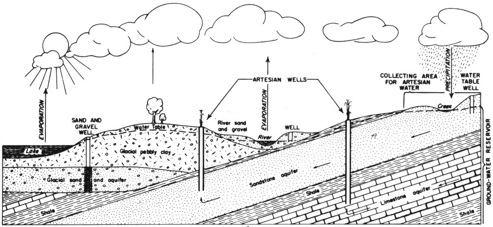
Figure 19—Source, movement, and occurrence of ground water. Arrows in aquifers show direction of flow of water.
EVAPORATION
SAND AND GRAVEL WELL
Water Table
River sand and gravel
ARTESIAN WELLS
EVAPORATION
River
WELL
COLLECTING AREA FOR ARTESIAN WATER
PRECIPITATION
Crater
WATER TABLE WELL
Lake
Glacial pebbly clay
Glacial sand and aquifer
Shale
Sandstone aquifer
Limestone aquifer
Shale
GROUND-WATER RESERVOIR
29
IS WATER FOUND IN UNDERGROUND LAKES AND RIVERS IN ILLINOIS?
No. There are a few large springs that flow from rocks along river bluffs in Illinois, but most ground water occurs in tiny openings within the rocks. Ground water reservoirs may be regarded as similar to sponges rather than as underground lakes or rivers.
WHY DO WELLS SOMETIMES GO DRY?
The water table rises and falls seasonally and from year to year, depending upon the amount of precipitation. Sometimes the water table may fall below the bottom of the well or below the pump. Sometimes overpumping the well or pumping too many wells in a small area lowers the water table sufficiently to check the yield of the well.
WHAT IS AN ARTESIAN WELL?
An artesian well is one in which pressure forces water to rise in the well above the level where it was found. In some artesian wells water flows out at the surface. Conditions for artesian wells are illustrated in figure 19. The shale above the sandstone and limestone aquifers in the figure is “tight” and does not permit water to escape upward to the level at which it enters the aquifers in the intake areas. The water is under natural pressure. When a well is drilled through the shale and into the aquifers, water rises, seeking its own level. Most of the deep wells in northern Illinois are artesian wells, though few of them flow at the surface anymore.
WILL YOU ALWAYS FIND WATER IF YOU GO DEEP ENOUGH?
This is generally true. However, in much of the southern two-thirds of Illinois the deeper waters are quite salty. Therefore, only the upper few hundred feet of rocks are worth exploring for water. In the northern third of Illinois, where the deepest water wells are located, fresh water extends in some places to more than 2,000 feet.
30
HOW CAN GROUND WATER BE FOUND?
The most effective way of locating a ground water supply is by using knowledge of the geology and ground water conditions—gained partly from study of existing well records—to determine the most favorable areas and depths to drill to.
An additional tool that has been used successfully in Illinois is the electrical earth resistivity survey. The resistivity survey attempts to locate buried sand and gravel layers that commonly are sources of ground water. Test drilling is recommended at sites that appear to be underlain by sand and gravel.
There is no known method that will positively “find” ground water without drilling.