Volume 3 — CHAPTER XXXIV. INTEROCEANIC COMMUNICATION. 1801-1887.
Reading edition
Ancient Ideas on the North-west Passage—From Peru to La Plata—Cape Horn Discovered—Arctic Regions—McClure's Successful Voyage—Crozier's Discovery—Franklin's Attempts—Finding by Nordenskiöld of the North-east Passage—Projects to Unite the Atlantic and Pacific Oceans across the Isthmuses—Plans about Tehuantepec—Explorations for a Ship-canal Route in Nicaragua, Panamá, and Darien—The Nicaragua Accessory Transit Company—Construction of the Panamá Railway, and its Great Benefits—Further Efforts for a Canal—Organization of a French Company—A Ship-canal under Construction across the Isthmus of Panamá—Difficulties and Expectations—Central American Railroads and Telegraphs—Submarine Cables.
No sooner had lands been discovered to the westward of Europe than the minds of cosmographers became fixed in the idea of short routes to India in that direction;[XXXIV-1] nor would they abandon it until long after both shores of the western continent had been explored from the Arctic sea to Cape Horn.[XXXIV-2]
EARLY EXPLORATIONS.
I have elsewhere presented a full account of explorations by land and sea to establish communications between the Atlantic and Pacific oceans prior to the opening of the present century.[XXXIV-3] The most important of the earlier discoveries, since Magalhaes' time, was that of the open polar sea south of Cape Horn, which was named by the Dutch navigators Le Maire and Van Schouten.[XXXIV-4] The north-west passage, so long the object of search, was at last found in 1851 by an English expedition. The discovery was effected by Robert Le Mesurier McClure, who, in command of the Investigator, sailed, together with the Enterprise under Richard Collinson, from England in 1850. Before the close of the year, McClure passed Point Barrow, pushed along the continent, doubled the south end of Banks Island, and sailed through Prince of Wales' Strait, where he wintered near Melville Sound. In 1851, the west side of the peninsular part of Wollaston Island to Prince Albert's Sound was surveyed. By finding the strait connecting the continental channel with Melville Sound, McClure became the discoverer of the north-west passage, and was the first navigator to pass from Bering Strait to Baffin Bay.[XXXIV-5] Yet he gave to Captain Crozier, second in command of Franklin's expedition, the credit of prior discovery. McClure with the Investigator was shut in during the winters of 1851-2, and 1852-3. In the spring of 1853 he resolved to abandon the ship and seek Mackenzie River and Lancaster Sound in two parties, a journey which would have been disastrous. At this moment, April 6th, Lieutenant Pym of the Resolute appeared.[XXXIV-6] The McClure party were taken to the Resolute, and reached England in 1854.
NORTH-EAST PASSAGE.
The north-east passage was discovered by Adolf Erick Nordenskiöld in 1879, after 326 years from the first attempt by Hugh Willoughby in 1553.[XXXIV-7]
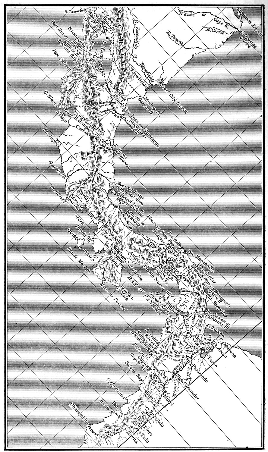
Interoceanic Communication.
The necessity of shorter communication between the two oceans becoming more evident from day to day, with the increase of traffic with the western coast of America, with China, and with the numerous islands of the Pacific, various projects were entertained to establish such communication either by canal or railway. At Tehuantepec, Honduras, Nicaragua, and the isthmus of Panamá were formed the most favorable conditions for a forced or artificial transit.[XXXIV-8]
TEHUANTEPEC ISTHMUS.
The breadth of the isthmus of Tehuantepec between the bays of Campeche and Tehuantepec at the narrowest point is 130 miles. It is drained by the rivers Coatzacoalcos and Tehuantepec, the former running northward, discharging its waters into the first-named bay, and extending over three fourths of the width of this isthmus; the latter flowing into the bay of Tehuantepec. There are several lakes and lagoons. At one time it was proposed to cut a canal across this isthmus, and to improve the navigation of the Coatzacoalcos, to which end surveys were made.[XXXIV-9] But no action having been taken toward constructing a canal by the parties to whom franchises had been given, the scheme of a railroad across this section has been also contemplated,[XXXIV-10] and finally a grant was made to James B. Eads, to construct a ship railway between the two gulfs, capable of having transported over it the largest ships with their cargoes.[XXXIV-11] The scheme has been declared by Eads, and by other engineers of high repute in Europe and America, to be practicable. His opponents deride it. He applied, without success, to the United States government for assistance.[XXXIV-12]
NICARAGUA ISTHMUS.
The idea of uniting the two oceans, by means of a canal across the isthmus of Nicaragua, occupied the attention of the Spanish court from a very early day after the conquest to the last years of its occupation of the country.[XXXIV-13] Since the separation of Central America from the crown, the canal scheme has ever been uppermost in the minds of her rulers and thinking men, and many scientific engineers and capitalists of Europe and America have taken a deep interest therein. But for divers reasons nothing was accomplished toward establishing an adequate interoceanic communication, in any form, down to 1849.[XXXIV-14] This year a new arrangement was made with Cornelius Vanderbilt and Joseph L. White of New York, in which the government of the United States, through its representative, E. George Squier, became concerned. This arrangement gave rise to complications with Great Britain, which were finally settled by the Clayton-Bulwer treaty to perpetually guarantee the neutrality of the canal to be constructed. The contractors failed to carry out their agreement as regarded the construction of a canal, but established the Accessory Transit Company, and by means of steamers on the two oceans, and on the river San Juan and Lake Nicaragua, rendered valuable service in the transportation of passengers. The matter was given in detail, in connection with the relations of that company with the Nicaraguan government, including its history from the date of the foundation till 1869, when it ceased to exist. However, their engineer, O. Childs, made a survey of the route for a canal in 1851, and recommended one from the mouth of Lajas River to Port Brito, traversing the Rio Grande Valley.[XXXIV-15] Since that time many schemes have been contemplated, and contracts entered into, but none of them have given the desired result.[XXXIV-16]
ACROSS MOSQUITIA.
I have yet to mention Pim's scheme, advanced in 1853, of building a railway from Punta Mico on the Atlantic to San Miguelito, on the eastern shore of the lake, traversing Mosquitia. A company was formed, but the project was soon found to be impracticable.[XXXIV-17]
No efforts have been spared ever since by Nicaragua and American citizens to bring about the accomplishment of the long-expected canal, under the impression that it is the most desirable, feasible, and least expensive route. The assistance of the United States government has been solicited, and treaties made to afford facilities, but the American congress has thus far refused to do anything, except send commissions to explore the several lines, and their reports seem to be favorable.[XXXIV-18] The last treaty concluded between the two governments with reference to a canal was rejected by the United States senate. The last survey made under the auspices of the American government was that of Engineer Menocal, of the United States navy, who, with other officers, visited Nicaragua in January 1885. His report was presented in November of that year. The plan of this commission had been at first to convert the river San Juan above its junction with the Sarapiqui into an extension of the lake by constructing a dam 74 feet high, but it was found impracticable. The proposed route extends from San Juan del Norte to Brito. The total length is 169.8 miles, of which 38.98 miles will be excavated canal, and 130.82 navigation by Lake Nicaragua, the river San Juan, the basin of the river San Francisco, and seven locks. Lake Nicaragua will be connected with the Pacific by a canal, and with the Atlantic by slackwater navigation in the river San Juan, by a short section of canal from the San Juan to the basin of the San Francisco, by navigation through this basin, and by a canal thence to the Caribbean Sea. The route has been divided into three divisions, the western, eastern, and middle.[XXXIV-19] The cost was carefully estimated, including a contingent of 25 per cent, at $64,043,697. De Lesseps is of opinion, however, that a canal with locks would be inadequate to pass the traffic that will frequent it, and would suffer from uncertainty of sufficient water to supply the lockage and evaporation.[XXXIV-20]
PANAMÁ ISTHMUS.
One of the four routes suggested by Antonio Galvao to the king of Spain, for cutting a canal to join the two oceans, was the Isthmus of Panamá.[XXXIV-21] Soon after New Granada threw off the Spanish yoke, several surveys of Panamá and Darien were made, and canal projects recommended;[XXXIV-22] two of them, deemed the most important, were that of Lloyd's to build a railroad from Panamá or La Chorrera to the Trinidad River, a tributary of the Chagres; and that of a sluiced canal recommended in 1843 by Garella and Courtines, who studied the Isthmus under a commission of the French government. And there were other projects.[XXXIV-23]
The attention of the United States government was directed to the subject of interoceanic routes as early as 1825. In 1835 the executive was requested by the senate to enter into negotiations with the Central American states and New Granada, conducive to treaties for the protection of Americans who might attempt opening the communication between the two oceans. A treaty was made by the United States with New Granada on the 12th of December, 1846, under which the latter guaranteed to the former "the right of way or transit across the Isthmus of Panamá, upon any modes of communication that now exist, or that may be hereafter constructed." The United States government on its part guaranteed to New Granada the neutrality of the Isthmus, and the rights of sovereignty and property over its territory.[XXXIV-24] At last an American company, being stimulated by the great traffic across the Isthmus, took up the matter of a railway.[XXXIV-25]
PANAMÁ RAILWAY.
The termini resolved on were Colon on the Atlantic, and on the Pacific, a little to the eastward of the city of Panamá, quite clear of the suburbs. The work was begun in January 1850, and finished on the 28th of January, 1855. Its total length is 47 miles, 3,020 feet. The line is a single one, but has four very commodious sidings; namely, Gatun, 7½ miles from Colon; one near Barbacoas, 22 miles; one at Matachin, 30 miles; and one at the summit, 37 miles. There are stations at every four miles. The undertaking was a bold one, and was successfully carried out under the able and energetic superintendence of George M. Totten.[XXXIV-26] The actual cost, as per construction account, was eight million dollars. The road has been improved from year to year. Articles of the coarsest and heaviest description, as well as ordinary merchandise, have been constantly conveyed over it. The road began to yield some income since 1852, when it had reached Barbacoas. I give in a note some statistics on receipts and expenditures.[XXXIV-27] The company from the beginning of its operations had a line of telegraph between Panamá and Colon. In 1881 the railway was sold to the company organized to construct a canal for $17,500,000, being at the rate of $250 per share. Adding other items, and interest on annual instalments, the share-holders received about twenty million dollars.[XXXIV-28]
A survey made by United States officers in 1866, through Chiriquí, showed that it was practicable to build a railway through the cordillera. The harbors of Chiriquí and Sheperd on the Atlantic, and of Golfito in Golfo Dulce, were favorably reported upon by Commodore F. Engle.[XXXIV-29]
VARIOUS SCHEMES.
But the idea of an interoceanic canal was ever present.[XXXIV-30] Nothing was practically done, until the whole subject was discussed in 1875 at the congress of geographical sciences held in Paris, and a company was organized under General Türr for effecting the requisite explorations. Lucien N. Bonaparte Wyse, a lieutenant of the French navy, assisted by other engineers, was sent out to the Isthmus. The exploring commission effected their work thoroughly, and the section from Colon to Panamá was given the preference.[XXXIV-31] The Colombian government granted on the 18th of May, 1878, to the Civil International Interoceanic Association, residing in Paris, the exclusive privilege for ninety-nine years of constructing a canal between the two oceans, at the same time establishing the neutrality of the ports at the termini, and of the canal itself.[XXXIV-32]
De Lesseps, of Suez Canal fame, undertook in 1879 the task of constructing the canal, and the first meeting of the company, now called Compagnie Universal du Canal Interocéanique de Panama, took place in 1881. It was calculated that six hundred million francs, or be it $120,000,000, would cover the expense of construction and completion. One of the company's first acts was to establish in New York a branch board of directors, and another was to purchase the Panamá railway.[XXXIV-33] The works were commenced in October 1881.[XXXIV-34] The canal in course of construction follows the route of the railway, though keeping closer to the bed of the Chagres, which it is to cross again and again; on the Pacific side it will descend the Rio Grande Valley, and continue seaward to the island of Perico, a total length of fifty-four miles.[XXXIV-35]
DIFFICULTIES TO OVERCOME.
The works have been prosecuted with more or less vigor, by the use of powerful dredges, until the capital became exhausted, and their operations declined for many months, seeming to confirm predictions of failure.[XXXIV-36] However that may be, De Lesseps and his friends are confident that the opening of the canal will become an accomplished fact within eight years from the time of commencement.[XXXIV-37] There can be no doubt that a large portion of the original capital was wasted, and if rumor is not at fault much was misappropriated. But public confidence in De Lesseps remains unshaken in France, and he has been able to obtain by subscription abundant funds to continue the work,[XXXIV-38] and it is now being vigorously pushed. His calculation is that there will be business for the canal to the extent of 7,250,000 tons, yielding 6 or 7 per cent on 2,000 million francs, or 108,000,000 francs, equivalent to $21,600,000.
This is not the place in which to speak of the several northern railways across the continent. The Central American states—exclusive of Panamá, which has had that benefit since 1855—have made some progress in late years toward establishing railway communication between the two seas. Guatemala has one line from Port San José, on the Pacific, to the capital,[XXXIV-39] and another from Port Champerico, also on the Pacific, to Retalhuleu.[XXXIV-40]
CENTRAL AMERICAN RAILWAYS.
Measures had likewise been taken to communicate the capital by railroads with the northern sea, contemplating at the same time to build another line from Coban to the Polochic River. However, these projects, so far as I know, have been, since President Barrios' death, in abeyance. The Spanish court was repeatedly urged to open communications between Puerto Caballos and the bay of Fonseca.[XXXIV-41] Traffic on mule-back was carried on between both seas in colonial times; but what we know of the isthmus of Honduras is derived from the surveys made by the British Honduras Interoceanic Railway Company, and reported by their agent, E. G. Squier. As a practicable route for a ship canal, Honduras is out of the question; but the construction of a railroad was begun between Puerto Caballos or Cortés, on the Caribbean Sea, and Amapala in the bay of Fonseca,[XXXIV-42] through the valley of the Goascoran and Humuya rivers—232 miles. The road was graded, and a narrow-gauge track was built from Port Cortés to San Pedro, of about 37 miles in length. The work was suspended in 1871, and abandoned in 1873. Civil disturbances and lack of means have prevented its resumption. Several franchises have been granted in later years for continuing it; but nothing of a practical nature has resulted.[XXXIV-43]
Salvador has no territory on the Atlantic slope. She has a railroad between San Miguel and Port La Union; another line is being built from Port Acajutla to the heart of the coffee region of Santa Ana. It is possible that in the future the republic may be placed in communication, by railway, with the Atlantic, through the territory of her neighbors.
In Nicaragua the line between Corinto and Chinandega, and hence to Leon, was in operation in 1881-2. The work steadily progressed. The western section was opened to public service in 1884, connecting it with the steam-ship line on the lake. Thus was Managua, the capital, placed in rapid and cheap communication by steam with Corinto, the chief port of the republic. The whole line from Momotombo to Corinto was yielding six and four fifths per cent on the capital invested. In the eastern section the work was going on rapidly at the end of 1884, and 20 miles to Masaya would soon be finished. The government contemplated to have a direct railway line from Villa de la Paz to Managua, thus establishing a continuous communication between Managua and Granada.[XXXIV-44]
Costa Rica, thus far, has three lines, or rather divisions or sections; namely, the Central, running between San Jose and the interior provinces, via Cartago, Heredia, Alajuela, Tres Rios, and San Joaquin; the Atlantic, from Limon to the interior, which is the route through which most of the country's foreign trade is carried on; and the Pacific which runs from Puntarenas to Esparta.[XXXIV-45]
TELEGRAPH LINES.
The five Central American republics are intersected by telegraph lines belonging to their respective governments, and communicating their chief towns with one another within themselves, and with the sister republics.[XXXIV-46] The isthmus of Panamá has a communication by submarine cable with Central America and Mexico at the port of La Libertad and Acapulco. The cities of Panamá and Colon are in direct communication by wire. The Isthmus is further connected by cable, on the Pacific, with Peru, via Buenaventura, which also places it in telegraphic communication with Bogotá and the rest of Colombia. A cable to Jamaica affords another connection, via Cuba, with the United States and Europe.[XXXIV-47]
The question of interoceanic communication by ship-canal across the isthmuses of Central America occupying, as it does, general attention, I have concluded to append hereto information on the subject by several competent authorities; namely, the British explorer, Dr Edward Cullen, and E. George Squier.
Ignorance respecting Darien.—It is a very singular circumstance that the coast of Darien, the first settled in America (Santa Maria having been founded in 1509, and Acla in Caledonia Bay in 1514), within eighteen days' steaming from England, close also to such frequented ports as Chagres, Carthagena, and Kingston, Jamaica, should be at the present day as unknown as the coasts of Patagonia or of New Guinea, and that the vast advantages of this tract of country, for a canal, should have escaped the penetration of the great Humboldt, who, after having examined all the maps in the Depósito Hidrográfico of Madrid, appears to suggest the Chuquanaqua. He says: 'On the Pacific coast, also, the deep Golfo de San Miguel, into which falls the Tuyra with its tributary, the Chuchunque, runs far into the Isthmus; the river Chuchunque, too, in the upper part of its course, runs within sixteen geographical miles of the Antillean shore of the Isthmus, westward of Cape Tiburon.' Views of Nature, Potsdam, June 1849, p. 432 of Bohn's translation.
The Atrato route labors under the disadvantage of a bad harbor, on the Pacific side, Cupica being of very small extent, and open to the s. w.; and the Atrato has a bar with only five feet of water on it, while the rise of tide in the Gulf of Darien is only two feet.
The Chagres, or Limon Bay and Panama route, surveyed in 1829 by Col Lloyd and M. Falmarc, under a commission from the Liberator, Simon Bolívar, and subsequently by M. Garella, has such bad harbors that the idea of a canal by that line has been totally abandoned.
The route from Chepo mouth to Mandinga Bay, proposed by Mr Evan Hopkins,[XXXIV-48] who attempted to survey it in 1847, for the New Granada government, although the narrowest line across the Isthmus, being only twenty-seven miles across from Chepo to Carti, has the disadvantages of bad coasts, a very high cordillera, of from 2,000 to 6,000 feet elevation, and a large population of Indians.
The bar at the mouth of Chepo River is quite dry at low water, as is also a sand bank which extends several miles out into the bay of Panamá; the part of the Atlantic coast on the other side is beset with reefs, shoals, and kays, and is dangerous of approach.
Capt Fitzroy, R. N., in his Considerations upon the Great Isthmus of Central America, suggests a line from the upper course of the Tuyra to the Atrato, or the coast of Darien above its mouth, as an improvement of the route proposed by me; but this would be nearly twice the distance of the Port Escocés, and gulf of San Miguel route; there would be the mountain of Chacargun or the Sierra de Maly to cross, and should the canal open into the Atrato, there would be the very formidable obstacle of the bar to remove, while of the coast above the Atrato mouth, the Columbian Navigator says: 'All this coast from Tarena Kays to Cape Tiburon is high and precipitous, with deep water off it; and it is very wild in the season of the breezes. It is very advisable, therefore, at these seasons, to shun it.' Any route, however, in this direction, would be included in the privilege granted, on the 1st of June, 1852, by the New Granada government, to Edward Cullen, Charles Fox, John Henderson, and Thomas Brassey, for cutting a canal from Port Escocés to the gulf of San Miguel, which gives power to select any place from the west mouth of the Atrato to Punta Mosquitos, for the Atlantic entrance of the canal.
DISCOVERY OF THE SAVANA RIVER.
Discovery of the Savana River and the Route for the Ship-canal. I imagine that the river Savana was not delineated in the maps which Humboldt saw.[XXXIV-49] Such, indeed, was the case with the map which I had on my first journey into Darien in 1849, so that I was totally ignorant of its existence until I actually saw it, after entering Boca Chica, when, finding the great depth of water at its mouth, and that it flowed almost directly from the north, I became convinced that I had at last found the object of my search, viz., a feasible route to the Atlantic, and thereupon immediately ascended it, and crossed from Cañasas to the sea-shore at Port Escocés and back, and subsequently, in 1850 and also in 1851, crossed and recrossed, at several times and by several tracks, the route from the Savana to Port Escocés and Caledonia Bay, notching the barks of the trees as I went along, with a machete or cutlass, always alone and unaided, and always in the season of the heaviest rains. I had previously examined, on my way from Panamá, the mouths of Chepo, Chiman, Congo, and several other rivers, but found them all obstructed by bars and sand banks, and impracticable for a ship passage, so that upon seeing the Savana, I had not the least hesitation in deciding that that must be the future route for interoceanic communication for ships.
The Darien Canal Route.—Port Escocés, or Scotch Harbor, and the bay of Caledonia, on the Atlantic coast of the Isthmus of Darien, present an extent of six nautical miles, from s. e. to n. w., of safe anchorage in all winds. These harbors are situated between Carreto Bay and the channel of Sassardi, and are 140 miles e. s. e. of Limon Bay, and twenty-one miles w. n. w. of Cape Tiburon, the n. w. boundary of the Gulf of Darien. Port Escocés extends to the s. e. to lat. 8° 50´ and long. 77° 41´; and Golden Island, or Isla de Oro, or Santa Catalina, which forms the n. w. boundary of Caledonia Bay, is in lat. 8° 54´ 40´´, and long. 77° 45´ 30´´.
The channel of Sassardi, also, extending from Caledonia Bay n. w. five miles to the Fronton, or point of Sassardi, is sheltered from the winds and seas of both seasons, and has good depth of water.
Twenty-two miles s. w. of Port Escocés is the site of the old Spanish settlement of Fuerte del Príncipe, on the river Savana, established in 1785, and abandoned in 1790. From thence the river Savana has nearly a s. by e. course for fourteen miles to its mouth, which opens into the river Tuyra, Santa Maria, or Rio Grande del Darien, three miles above Boca Chica and Boca Grande, the two mouths by which the latter discharges itself into the Gulf of San Miguel on the Pacific.
Thus the distance from the Atlantic to the Pacific Ocean, by the route from Port Escocés or Caledonia Bay, to the gulf of San Miguel, by way of the river Savana, would be thirty-nine miles. In a direct line, from Port Escocés to the gulf, the distance is thirty-three miles.
In Considerations on the Great Isthmus of Central America, read before the Royal Geographical Society of London, on the 11th and 25th Nov., 1850, Captain Fitzroy, R. N., says: 'Any route that could be made available between San Miguel Gulf and Caledonia Bay, or the Gulf of Darien or Choco, would have the advantage of excellent harbors at each end, and a great rise of tide in one of them (San Miguel). The river Savana is recommended by Dr Cullen from personal examination, as being more navigable (for canoes[XXXIV-50]), and approaching nearer the north coast than the Chuquanaqua does; though this does not appear in the Spanish maps. From the head of the Savana, a ravine, about three leagues in length, extends to Caledonia Bay, and there (Dr Cullen says, having passed through it) he thinks a canal might be cut with less difficulty than elsewhere, if it were not for the opposition of the natives. He also speaks of the Indians transporting their canoes across at this ravine, and of the comparative healthiness of this part of the Isthmus.'
The whole work to be done, in order to make a ship-canal communication between the Atlantic and Pacific oceans by this route, would be to cut from Príncipe or from Lara mouth to Port Escocés or Caledonia Bay, a distance of from twenty-two to twenty-five miles, of which there would be but three or four miles of deep cutting.
The canal, to be on a scale of grandeur commensurate with its important uses, should be cut sufficiently deep to allow the tide of the Pacific to flow right through it, across to the Atlantic; so that ships bound from the Pacific to the Atlantic would pass with the flood, and those from the Atlantic to the Pacific with the ebb tide of the latter. Such was the plan recommended in my report to Lord Palmerston. By such a canal—that is, one entirely without locks—the transit from sea to sea could be effected in six hours, or one tide.[XXXIV-51]
For the engineering details, and estimates of the cost of the work, I beg to refer to the valuable report of Mr. Lionel Gisborne, C. E., who, with his assistant, Mr. Forde, was commissioned, last April, by Messrs Fox, Henderson, and Brassey, to survey this route, which they found to be perfectly feasible for a ship-canal communication, and fully as eligible as I had represented it.
PASSAGE FOR THE PACIFIC TIDE.
It is needless to say that, under the auspices of Messrs. Fox, Henderson, and Brassey, who, with that clear discernment and prompt decision, which have placed them in the elevated position which they occupy, adopted this route in December 1851, after a careful examination of my statements, the great work of an interoceanic canal is sure, erelong, to be accomplished.
I trust that an attentive consideration of the advantages of this route—viz., its shortness, the excellence of its harbors, the low elevation of the land, the absence of bars at the Savana and Tuyra mouths, the depth of water and great rise of tide in the former, its directness of course and freedom from obstructions, the healthiness of the adjacent country, the exemption of the coasts from northers and hurricanes, the feasibility of cutting a canal without locks, and the absence of engineering difficulties—will fully justify me in asserting it to be the shortest, the most direct, safe, and expeditious, and in every way the most eligible route for intermarine communication for large ships.
An examination of the physical aspect of the country from Port Escocés to the Savana—presenting, as it does, but a single ridge of low elevation, and this broken by gorges, ravines, and valleys, and grooved by rivers and streams, with a champaign country extending from its base on each side—will prove the feasibility of making the canal entirely without locks, a superiority which this route possesses over others, which all present insurmountable physical obstacles to the construction of such a canal.
In fact, a glance at the map ought to convince the most sceptical that nature has unmistakably marked out this space for the junction of the two oceans, and the breaking of the continuity of North and South America; indeed, so narrow is the line of division, that it would almost appear as if the two seas did once meet here.
Details of the Route Proposed.—I shall now enter into a more detailed description of this route, which I discovered in 1849, and proposed for a ship-canal communication between the Atlantic and Pacific oceans in the Panamá Echo of February 8, 1850, in the Daily News and Mining Journal of May 1850;[XXXIV-52] in a paper presented to the Royal Geographical Society, and read at the Edinburgh meeting of the British Association in July 1850; and in a report to Lord Palmerston, of January 15, 1851.
Port Escocés.—Of Port Escocés, Caledonia Bay, and the channel of Sassardi, the Columbian Navigator, vol. 3, p. 218, says:
'Port Escocés, or Caledonia, lat. 8° 51´, long. 77° 44´, is a noble harbor; very safe, and so extensive that a thousand sail of vessels may enter it.
'Punta Escocés is the s. e. point of Caledonia Bay, the greater islet of Santa Catalina, or de Oro (gold), being the n. w. Between point and point the distance is four miles, and the points lie n. w. and s. e. (n. 40° w., and s. 40° e.), from each other; and in respect to this line the bay falls in one mile and two thirds. In the s. e. part of this bay is Puerto Escocés (or Scottish Harbor), which extends inward two miles in that direction, and forms good shelter. There are various shoals in it, which are represented in the particular plan of the harbor, by which plan any vessel may run in, for the depths are five, six, seven, and eight fathoms of water over a bottom of sand.
'Between Piedras Islet to the north, the west point of Aglatomate River to the south, and that of San Fulgencio to the S. W., is formed the Ensenada, or bay of Caledonia, and the channel of Sassardi.
Caledonia Bay.—'The Ensenada, or cove of Caledonia, is, strictly speaking, formed by the points already mentioned, which lie with each other n. n. w. ¾ w., and s. s. e. ¾ e. (n. 25° w., and s. 25° e.), one mile distant. This bay is clean, and has good deep water; the greater part of its coast is a beach, and near the middle of it disembogues the river Aglaseniqua. The point of San Fulgencio is salient, scarped, and clean, and it also forms an indent with little depth of water, bordered by mangroves and various kays at its western part.
The Channel of Sassardi.—'Between San Fulgencio point, the great Oro Island, Piedras Islet, and the Mangrove Kays, which are to the west of them, the channel of Sassardi is formed; the s. e. entrance to this channel is off and on, with four cables' length in extent, from edge to edge, and with from nine to twelve fathoms depth on oaze; and farther in, from eight to ten fathoms; as also between the turn of the bank off Piedras Islet, and the bay of Caledonia, the depth is from seven to fifteen fathoms; and the piece of sea which intervenes between this bay and the Puerto Escocés is of a good depth of water; but at a short mile s. e. by e. ½ e. (s. 55° e.), from Piedras Islet the sea breaks when the breeze blows fresh.'
From its entrance the channel of Sassardi extends n. w. five miles.
The engineer has here, then, a wide scope for selecting a locality for the Atlantic mouth of the canal, which may thus open anywhere from the s. e. end of Port Escocés to the n. w. entrance of the Channel of Sassardi, an extent of eleven nautic. miles.
Along a great extent of Port Escocés and Caledonia Bay, vessels can lie so close in shore that no boats would be necessary in the taking in or discharging cargo; the same great advantage also presents itself at several points in the channel of Sassardi.
SOURCES OF FRESH WATER.
Good fresh water may be obtained in abundance from any of the numerous streams which fall into these harbors, particularly from the Aglaseniqua or Aglatomate.
Port Escocés is entirely uninhabited, nor is there any settlement in and of it; at Caledonia, near the mouth of the Aglaseniqua, there are five huts, inhabited by a few Indians of the Tule tribe, and about two leagues up the river is another small settlement; this, however, is at a considerable distance westward of the projected line of canal.
From the sea-shore a plain extends for nearly two miles to the base of a ridge of hills, which runs parallel to the coast, and whose highest summit is about 350 feet. This ridge is not quite continuous and unbroken, but is divided by transverse valleys, through which the Aglaseniqua, Aglatomate, and other rivers have their course, and whose highest elevations do not exceed 150 feet.
The base of this ridge is only two miles in width; and from its south side a level plain extends for thirteen miles to a point on the river Savana, called Cañasas, which is about twenty miles above its mouth.
The river Savana, at Cañasas, has a depth of six feet of water, but is obstructed by ledges of a slate, called pizarra, or killes, for four miles, down to the mouth of La Villa, up to which the tide reaches. At Cañasas, there is a forest of a species of bamboo, so dense as to be impenetrable; and above it there is a fall of two feet, when the river is low, but after rains this entirely disappears. The first fall, in ascending the river, occurs at Caobano, a little above La Villa.
From La Villa, where there is a depth of ten or twelve feet, the river is perfectly free from obstructions down to Príncipe.
At Fuerte del Príncipe, two miles below La Villa, there is a single ledge of slate, visible only in a very low state of the river, which has here a depth of three fathoms, and a rise of tide of six feet. The banks of the river are elevated about ten feet above the level of the water, and are quite free from swamp. The site of the old Spanish settlement is here indicated by a patch of very dense scrubby bush, without high trees, on the west bank of the river; but the only remains to be met with are some fragments of botijas, or water-jars. Príncipe is in lat. 8° 34', and long. 77° 56', by my observations; it is only two or three hours' journey from the mouth of the river.
The Savana River, called by the Indians Chaparti, is very direct in its course, from Príncipe to its mouth, and free from sinuosities, playas, deep elbows, shoals, rocks, snags, or other obstructions.
Its banks, elevated several feet above the level of the water, are quite free from swamp and malarious miasmata, consequently the endemic fevers caused by these in Chagres, Portobello, Limon, and Panama, would not prevail in any settlements that may be formed in the neighborhood of the Savana. Indeed, it cannot be inferred that the Isthmus of Darien is unhealthy, because the towns on the Isthmus of Panama have all been settled in swampy localities, and in the most unfavorable positions in a sanatory point of view. A convincing proof of the freedom from swamp of the whole tract of country, from Port Escocés to the gulf of San Miguel, is the total absence of musquitoes, which invariably infest all swampy grounds in the tropics. The great longevity of the people of Darien, and the large proportion of very old men, also attest the healthiness of the climate.
From Príncipe to the mouth of Matumaganti, one mile s. s. w., the river increases greatly in width and depth; there are some islands in this reach; and on the west bank a very large cuipo-tree stands conspicuous, towering above the adjacent forest.
From Matumaganti to the mouth of Lara, two miles, the river has a depth of four fathoms, and a rise of tide of ten feet.
From Lara mouth to the islands in the second reach, four miles, the river is very direct in its course, with a depth of five or six fathoms. A ridge of hills runs parallel to each bank, at about two miles' distance. Just below this mouth, and above a widening of the river, called Revesa de Piriaki, is Cerro Piriaki, a hill of about 400 feet elevation, and above this there is no hill near either bank of the Savana. Above the islands, Estero Corotu, Rio Corredor, and other streams fall into this, the Calle Larga, or Long Reach.
From the islands to Areti mouth, s. s. e., three miles, the river has great width and depth; a ridge of hill here runs along each bank, at about two miles' distance.
RELATIVE WATER DEPTHS.
Junction of the Savana and Tuyra.—From Areti mouth to the junction of the Savana and Tuyra rivers, S., four miles, the river has a uniform width of two miles, and a depth of from eight to nine fathoms.
On the west bank of this reach is Punta Machete, with a small shoal above it, called Bajo Grande, and one below it, Bajo Chico. Both of these are close in shore, and oysters are found on them.
The Savana Mouth.—From the west point of the Savana mouth, in lat. 8° 21', long. 77° 54', the land rises into a ridge of hills of about 309 feet elevation, running n. for about four miles parallel to the river, from which it is separated by a strip of level land half a mile wide. There is a quebrada, or rivulet, in the ridge, called Laguadilla, which has plenty of fresh water in the driest season.
Behind Nisperal, the east point of the Savana mouth, there is a low ridge of hills; from the north bank of Iglesias, also, a narrow ridge follows the course of the Savana for about three miles. This is the Cerro Titichi, which gave its name to a mission of Indians at the mouth of the Chuquanaqua, the last survivor of whom is a man named Marcellino, who resides at Pinogana, on the Tuyra. On the north bank of Iglesias is Quebrada de Tigre, and on the Savana, above its mouth, is Quebradita la Monera, where fresh water may be obtained.
At the mouth of the Savana there are nine fathoms, at low water, and the tide rises from twenty-one to twenty-seven feet.
Boca Chica and Boca Grande, the mouths of the Tuyra, are perfectly safe entrances, and have a depth of thirteen to twenty fathoms of water respectively.
The gulf of San Miguel has good depth of water, and would hold the shipping of the world. Its mouth, between Cape San Lorenzo on the north, and Punta Garachiné on the south, is ten miles across, and opens into the Pacific, quite outside the bay of Panama. Its direction inward is n. e. fifteen miles to Boca Chica. Inside the bay of Garachiné, the shores of the gulf approach each other, and the width diminishes to four miles, between Punta Brava and Morro Patiño, with a depth of from nine to twenty fathoms, but again increases, and then diminishes to Boca Chica.
Close to Cape San Lorenzo is a small shoal, called El Buey, which may be easily avoided. There are several islands in the gulf, as Iguana, Cedro, Islas de San Diego, etc., etc., which are all safe of approach. On the north side, the rivers Congo, Buenavista; and on the south the Moguey, Guaca, Taimita, and Sambú, open into the gulf; while the Tuyra and Savana fall into its eastern end, the Ensenada del Darien, called by the Granadians 'Boca de Provincia,' or Mouth of the Province. Cullen's Isth. of Darien.
From what has been said, it sufficiently appears that Nicaragua is a country of great beauty of scenery and vast natural resources. She has, however, attracted the attention of the world less on these accounts than because she is believed to possess within her borders the best and most feasible route for a ship-canal between the two great oceans. The project of opening such a canal began to be entertained as soon as it was found that there existed no natural communication between the seas, as early as 1527. Since that period it has furnished a subject for much speculation, but beyond a few partial examinations, until very lately, nothing of a practical or satisfactory character had been attempted. In 1851 a careful survey was made of the river San Juan, Lake Nicaragua, and the isthmus intervening between this lake and the Pacific, by Colonel O. W. Childs, previously engineer-in-chief of the state of New York, under the direction of the now extinct Atlantic and Pacific Ship-canal Company. Until then, it had always been assumed that the river San Juan, as well as the lake itself, could easily be made navigable for ships, and that the only obstacle to be overcome was the narrow strip of land between the lake and the ocean. Hence, all the so-called surveys were limited to an examination of that part of the line. One of them was made under the orders of the Spanish government, by Don Manuel Galisteo, in 1781; another, and that best known, by Mr. John Baily, under the direction of the government of Central America, in 1838. An intermediate examination, quoted by Thompson,[XXXIV-53] seems to have been made early in the present century. The following table will show the results of these surveys as regards this particular section:
Authorities. Distance from Lake to ocean. Greatest Elevation above Ocean. Greatest Elevation above Lake.
Galisteo, 1781 17 miles, 200 feet. 272 feet. 134 feet.
Quoted by Thompson, 1829 17 miles, 320 feet 296 feet 154 feet
Baily, 1838 16 miles, 730 feet 615 feet 487 feet
Childs, 1851 18 miles, 3,120 feet 159 feet 47½ feet
As the survey of Colonel Childs is the only one which can be accepted as conforming to modern engineering requirements, it will be enough to present the detailed results to which he arrived. The line proposed by him, and on which all his calculations and estimates were based, commences at the little port of Brito, on the Pacific, and passes across the Isthmus, between the ocean and lake, to the mouth of a small stream called Rio Lajas, flowing into the latter, thence across Lake Nicaragua to its outlet, and down the valley of the Rio San Juan to the port of the same name on the Atlantic. The length of this line was found to be 194⅓ miles, as follows:
Miles.
Western Division.—Canal from the port of Brito on the Pacific, through the valley of a small stream called Rio Grande, falling into the Pacific, into that of the stream called Rio Lajas, to Lake Nicaragua 18.588
Middle Division.—Though Lake Nicaragua, from mouth of Rio Lajas to Fort San Carlos, at the head of San Juan River 56.500
Eastern Division.—First Section.—Slack-water navigation on San Juan River from San Carlos to a point on the river opposite the mouth of the Serapiqui River 90.800
Second Section.—Canal from opposite mouth of Serapiqui to port of San Juan del Norte 28.505
Total, as above 194.393
Origin of the Canal Grant.—The charter of this company under which Colonel Childs carried on his investigations is dated September 22, 1849, and was obtained for a term of eighty-five years from the completion of the proposed canal. The surveys were to be commenced within one year, and the whole to be completed in twelve years. The canal, by the terms of the charter, was to be of dimensions sufficiently great to admit and pass vessels of all sizes with speed and safety. The company was to pay to the state, during the period assigned for the construction of the work, the annual sum of $10,000; to give to the state $200,000 of stock in the canal, on the issue of stock; the state to receive, for the first twenty years, twenty per cent annually out of the net profits of the canal, after deducting the interest on the capital actually invested, at the rate of seven per cent; and for the remaining sixty-five years, twenty-five per cent of the profits. The company, on the other hand, were to receive fifteen per cent annually out of the net profits of the canal for the first ten years after it should revert to the state, provided it did not cost over $20,000,000; but if it should cost more than that sum, the company to receive twenty per cent for twenty years. During the period of constructing the canal (twelve years), the company had the exclusive right of navigating the waters of the state by steam, and also the privilege of opening a transit route through its territories, upon the principal condition of paying ten per cent of the net profits to the state. There were some other provisions as to lands, tolls, etc., of no special importance.
Under this charter, the company perfected its organization. It divided its original shares into a considerable number, called 'canal rights,' which were sold, and their holders brought into the organization. The first instalment was paid, and in August 1850, just in time to meet the stipulation providing that the surveys should be commenced within one year from the date of the contract, a party of surveyors was sent out to Nicaragua. They were under the direction (as already said) of Colonel O. W. Childs as chief engineer. He arrived in Nicaragua on the 27th of August, 1850, and so far as his report is concerned, we are left to infer that he at once commenced the surveys for the canal. His report is dated March 9, 1852.
DIVERSIONS OF THE CANAL.
The Line of Survey.—In the various projects for uniting the two seas, the line of the river San Juan has always been contemplated as that by which the great lake of Nicaragua is to be reached. From that lake to the Pacific, various routes have been suggested:
1. From Lake Nicaragua via the river Sapoa to the bay of Bolaños, in the gulf of Salinas, on the Pacific.
2. Via the Rio Lajas to the port of San Juan del Sur, or some point not far from it, on the Pacific.
3. Via the Rio Tipitapa into the superior lake of Managua, and from this lake to the Pacific at the little port of Tamarindo, the port of Realejo, or into the magnificent gulf or bay of Fonseca.
By his instructions, Colonel Childs was limited to a survey of the direct routes from Lake Nicaragua to the Pacific, provided either of them should prove practicable. As a consequence, finding a route which, in his opinion, was practicable, he made no surveys from the superior lake of Managua to the Pacific. He, however, made some observations on the line of the connection between the two lakes by the river Tipitapa—if a channel dry for most, if not all, of the year can be called a river. This is a source of great regret, especially in view of the deficiency, on the surveyed routes, of a good harbor on the Pacific, while both Realejo and the gulf of Fonseca are all that can be desired as ports.
Lake Nicaragua is estimated by Colonel Childs to be one hundred and ten miles in extreme length by thirty-five in (average) width. Its nearest approach to the Atlantic is at its southern extremity, from which, on a right line, it is about eighty miles distant. The point of its nearest approach to the Pacific is near the middle of its length, where, by the shortest line, the distance is about eleven miles.
The San Juan River was found by Colonel Childs to be, following its sinuosities, 119 miles in length. It has a great number of tributaries, generally small, with the exception of the San Cárlos and Serapiqui, which come in from the mountains of Costa Rica on the south. The first of these enters the San Juan at sixty-five miles, and the second ninety miles below the lake. These streams flow through valleys transversely to that of the San Juan, which is further intersected by ranges of hills, coming in both from the north and the south, at the Rapides del Toro, Castillo, Machuca, etc.
The lake of Nicaragua lies longitudinally, nearly parallel to the Pacific Ocean, and is separated from it, for nearly two thirds of the length of the lake, by hills of comparatively moderate acclivity and elevation, in most cases capable of cultivation to their summits. Within this distance, also, are several transverse valleys, extending nearly (Colonel Childs says quite) across, with summits varying in height, and furnishing generally good opportunities for direct communications by ordinary roads or by canal.
Route via River Sapoa.—This line lies chiefly in the department of Guanacaste, now in dispute between Nicaragua and Costa Rica, and actually occupied by the latter.
The examination of this line by Colonel Childs only proved its impracticability for the purpose of a canal. He found that to pass the summit a cut 119 feet in depth would be required, and an up-lockage from the lake of 350½ feet, and a down-lockage to the Pacific of 432 feet. Water to supply the upper locks, it was ascertained, could only be obtained with difficulty, and at great cost. Besides, a long rock cut of three fourths of a mile would be required from low-tide mark in the bay of Salinas to deep water. In short, the physical difficulties on this line, if not of a nature to make the construction of a canal impossible, were nevertheless such as to make it impracticable.
Route from Mouth of the Rio Lajas to Brito.—The line from Lake Nicaragua to the Pacific, to which public attention has been most directed, is one starting from the mouth of the Rio Lajas, a few miles below the town of Rivas, or Nicaragua, to the port of San Juan del Sur, or Concordia, on the Pacific. As already stated, not less than three surveys had been made over this line; one in 1781 by Galisteo, a Spanish engineer, and the last by Mr. Baily, an Englishman, under the republic of Central America, published in Stephens' Incidents of Travel in Central America. The line pursued by both Galisteo and Baily was governed by the circumstance of a measurably good port on the Pacific—that of San Juan del Sur, the best on the whole line of coast from the bay of Salinas northward to Realejo. Baily's line is sixteen miles and 730 feet in length, and the greatest elevation above the lake 487 feet. That of Galisteo is seventeen miles 200 feet in length, and the greatest elevation above the sea 272, and above the lake 134 feet. Baily's line, for half of its distance, involved 209 feet of average vertical cutting; that of Galisteo, for half of its length, an average vertical cutting of 108 feet. These facts, and others, among which the absolute impossibility of supplying the summit levels with water, and the necessity of tunnels, combined to make the construction of a canal on this line wholly impossible.
EXPLORING FOR A LINE.
Colonel Childs seems to have been satisfied of the impracticability of this line, after a very rapid examination, and to have devoted himself to the discovery of one more feasible. In doing this, however, it was found necessary to abandon San Juan del Sur as the western terminus.
Starting at the point on the lake to the eastward of Rivas, levelling westward, through a transverse, moderately undulating plain, he ascended, on a distance of six and a half miles, 326 feet, to the summit of a broad valley, passing between the hills (which are here of moderate height), and connecting with another valley on the west side, which extends to a place on the Pacific called Brito, where a stream, named Rio Grande, flows into the sea. The quantity of water available for this summit being entirely inadequate, and the cut altogether too formidable, on the plan of carrying through the level, this route was abandoned. Another line, not far from this, was attempted, with very nearly the same result.
Colonel Childs next started from the mouth of the Rio Lajas, the same point with his predecessors, and carried a line of levels to the summit of a transverse valley lying about six and a half miles south of Rivas, and reaching between the valley of Rio Lajas and that of the Rio Grande, already mentioned as flowing into the Pacific at Brito. This summit was found to be only forty-seven and a half feet above the surface of the lake, as it stood on the 23d day of December, 1850, at which time it was three and a half feet above its lowest stages, and one and a half feet below the level at which it ordinarily stands at the height of the rainy season. The length of this line from lake to sea is about twenty miles. This is the route, and the only direct one, between the lake and sea, regarded by Colonel Childs as feasible, and upon this all his calculations respecting the proposed canal are based. In his own language: 'The conclusion was arrived at that the line leading from the lake, at the mouth of the river Lajas to the Pacific at Brito, presented more favorable conditions for the construction of the canal than any other; it was therefore determined to survey and carefully to locate a line across upon this route.'
This line, then, runs through the valley of the river Lajas, the waters of a principal branch of which interlock with those of the Rio Grande, and, through the valley of the latter, reaches the sea. The stream first named has its origin about ten miles south-westerly from its entrance into the lake, on the eastern slope of the dividing ridge, and after running north-westerly two miles, along the base of the hills, takes a northerly direction through comparatively level savannas, a distance of six miles or eight miles, when it bends to the east, and in a mile and three fourths enters the lake. The Rio Grande rises on the eastern slope of the same range of hills, and two or three miles north-west from the sources of the Lajas, and, after flowing some three or four miles at the foot of their slope, bends to the west, and by a narrow and somewhat irregular valley passes through the ridge, and thence, in a more capacious and uniform valley, into the Pacific.
Western Section of Proposed Canal between Lake Nicaragua and the Pacific.—The entire line of the canal proposed by Colonel Childs, and upon which all his calculations and estimates are based, is therefore through the valley of the river San Juan into Lake Nicaragua, across Lake Nicaragua to the mouth of the Rio Lajas, through the valley of that stream, and across the summit of forty-seven and a half feet which separates it from that of the Rio Grande, and down the valley of the Rio Grande to Brito, where that stream enters the Pacific.
Now, in order to understand Colonel Childs' conclusions, and appreciate the data which he gives, we must know what kind of a work he proposes. He contemplates a canal but seventeen feet deep; and as he intends to supply the western section, from the lake to the sea, by water from the lake, it would be necessary to commence construction in the lake at a point where the water is seventeen feet deep at mean stage. This point is opposite the mouth of the Lajas, and twenty-five chains from the line of the shore. From this point, for a mile and a half, partially along the river Lajas, the excavation will be principally earth; but beyond this, for a distance of five and a half miles, which carries the line beyond the summit, three fourths of the excavation will be in a trap rock. That is to say, the deepest excavation, or open cut, will be sixty-five feet, and involve the removal of 1,879,000 cubic yards of earth, and 3,378,000 cubic yards of rock. The excavation and construction in this five and a half miles alone are estimated at upward of $6,000,000.
The summit passed, and the valley of the Rio Grande reached, the excavation, as a general rule, will be only the depth of the canal. Colonel Childs found that the lake, at ordinary high water, is only 102 feet 10 inches above the Pacific at high and 111 feet 5 inches above it at low tide, instead of 128 feet, as calculated by Mr. Baily. This descent he proposes to accomplish by fourteen locks, of eight feet lift each, placed at proper points in the valley of the Rio Grande, thus bringing us to Brito, the terminus on the Pacific.
The harbor of Brito, as it is called, or the point where the Rio Grande enters the sea, is at best only a bad anchorage. There is here a small angular indentation of the land, partially protected by a low ledge of rock, but nothing adequate for the terminus of an important work like the proposed canal, or capable of answering the commonest requisites of a port. To remedy this deficiency, Colonel Childs proposed to construct an artificial harbor, of thirty-four acres area, by means of moles and jetties in the sea, and by extensive excavations in the land. If, as he supposes, the excavations here would be in sand, it is obviously almost impossible to get proper foundations for the immense sea-walls and piers that would be necessary for a work of this kind. On the contrary, if these excavations should be chiefly in a rock, as seems most likely, the cost and labor would almost surpass computation. Assuming the excavations for the purpose to be in earth and sand, Colonel Childs estimates the cost of making a harbor at a little over $2,600,000.
Middle Section of Proposed Canal—Lake Nicaragua.—Proceeding from seventeen feet depth of water in the lake, opposite to the river Lajas, in the direction of the outlet of the lake at Fort San Cárlos, there is ample water for vessels of all sizes for a distance of about fifty-one miles, to a point half a mile south of the Boacos Islands. Here the depth of water diminishes rapidly to fourteen feet. For the remaining five and a half miles to the fort, the water is variable, averaging only about nine feet at low and about fourteen at high water. For this distance of five and a half miles, therefore, an average under-water excavation of eight feet would be required to make the channel, at low water, of the depth of the canal, or seventeen feet. But if the lake were kept at high level, the under-water excavation would be but an average of three feet.
Colonel Childs proposed to protect this portion of the channel by rows of piles driven on each side, along its whole extent, and thinks, after the excavation were made, a sufficient current would be established to keep the channel clear.
THE RIVER SAN JUAN.
Eastern Section—The River San Juan.—We come now to the section between Lake Nicaragua and the Atlantic, through or along the river San Juan. Excepting a small settlement at the Castillo Viejo, at the Castillo Rapids, thirty-seven miles from the lake, the valley of the San Juan is wholly uninhabited. This section, hitherto supposed the easiest, is, nevertheless, by far the most difficult part of the proposed enterprise.
Colonel Childs carried a line of levels from the lake at San Cárlos to the port of San Juan, on the northern bank of the stream. The whole distance from San Carlos to seventeen feet depth of water in the harbor of San Juan is 119⅓ miles; and the whole fall, from the surface of high lake to the surface of highest tide in the harbor, is 107½ feet—to lowest tide, 108¾ feet.
Of the above distance, the first ninety-one miles, or from San Carlos to half a mile below the Serapiqui River, Colonel Childs proposed to make the river navigable by excavating its bed, and by constructing dams, to be passed by means of locks and short canals; the remaining twenty-eight miles of the canal to be constructed inland, or independently of the river. Of the whole fall, sixty-two and a half feet occurs on that portion which it is proposed to improve by dams, and on which there were to be eight locks, and the remaining forty-six and a quarter feet occurs on the inland portion of the canal, on which were to be six locks—fourteen locks in all.
Colonel Childs proposed to place the first dam at the head of the Castillo Rapids, a distance of upward of thirty-seven miles from the lake, and to pass the rapids by means of a lateral canal. By means of this dam he proposed to raise the water, at that point, twenty-one and a half feet, and the entire level of Lake Nicaragua five feet above its lowest stages, or in other words, to keep it at high-water mark. The fall at this dam would be sixteen feet. He proposed also six other dams, four of eight feet fall, one of fourteen and a half feet, and one of thirteen and a half feet. Between all of these there would be more or less excavation in the bed of the stream, sometimes in earth, and often in rock.
Colonel Childs proposed further to improve the harbor of San Juan by moles, etc., and to construct an artificial harbor in connection with it of the capacity of thirteen acres.
In respect of the amount of water in the San Juan, we have some interesting statistics. This amount, of course, varies greatly with the different seasons. The quantity of water that passed from the lake at its lowest stage, on the 4th of June, 1851, was 11,930 cubic feet per second. The greatest rise of the lake is about five feet. When it stood at 3.43 feet above its lowest level, the flow of water was 18,059 cubic feet per second, being an increase of about fifty per cent. Supposing the same ratio of increase, at high lake the amount of water in the river would be doubled.
The river receives large accessions from its tributaries. Below these, and above the point of divergence of the Colorado, flowing direct into the sea from the San Juan, which falls into the harbor of the same name, the flow of water was 54,380 cubic feet per second, of which 42,056 passed through the Colorado branch into the ocean, and 12,324 through the San Juan into the port.
Dimensions of the Proposed Canal.—Where the excavation is in earth, Colonel Childs proposed (and all his estimates are founded on these dimensions) that the canal shall have a depth of 17 feet; that it shall be 50 feet wide at the bottom, 86 feet wide at 9 feet above the bottom, and 118 feet wide at the surface of the water. Where the excavation is in rock, the canal is to be 50 feet wide at bottom, 77 feet at 9 feet above bottom, and 78⅓ feet at the surface of the water.
Length of Proposed Canal.—The total length of the line proposed by Colonel Childs, from San Juan del Norte on the Atlantic, to Brito on the Pacific, is 194⅓ miles, as follows:
Miles.
Canal from port of San Juan to its point of intersection with the river, near the mouth of the Serapiqui 28.505
Slack-water navigation on the San Juan River, from the above point to San Cárlos, at the outlet of the lake 90.800
From San Cárlos, across Lake Nicaragua, to the mouth of the Rio Lajas 56.500
From mouth of Rio Lajas to Brito 18.588
Total, as above 194.393
Estimated Cost.—The cost of the work is estimated by Colonel Childs in detail. The recapitulation, by divisions, is as follows:
Eastern Division (i. e., from port of San Juan to lake) $12,502,346
Middle Division (through lake) 1,025,676
Western Division (from lake to Pacific) 13,896,603
$27,424,625
Add, for contingencies, 15 per cent 4,113,693
Total estimated cost of canal $31,538,318
The canal company published a pamphlet, in which the estimates for the canal were made at New York prices, and in which the total was put down at $13,243,099. 'The prices adopted in the estimate of $31,500,000,' says Colonel Childs, 'are made up with reference to the completion of the work within six years from the time of breaking ground, and a commencement of the settlement of the country in the vicinity of the line previous to letting the contracts.'
Capacity of the Proposed Canal.—The charter of the canal company provided that the capacity of the work should be sufficiently great 'to admit vessels of all sizes.' And it is obvious that a work which will not pass freely the largest vessels can but imperfectly answer the purposes of its construction, or meet the requirements of commerce. But Colonel Childs proposed only one 17 feet deep, 50 feet wide at bottom, and 118 feet wide at top—a capacity wholly inadequate to pass the larger classes of vessels, and one which fails to meet the stipulations of the charter. The larger merchant-ships, such as are generally employed in the eastern trade, have a draught of from 20 to 25 feet, and would require, to say nothing of war vessels and large steamers, a canal of from 25 to 30 feet in depth, which would involve more than double the amount of excavation proposed, and probably treble the amount of cost, and carry it up from $31,500,000 to $100,000,000. Here is the fatal deficiency in the whole proposition of Colonel Childs.
To make the canal capable of passing vessels drawing 20 feet of water, Colonel Childs says, would increase to a very great degree the amount of the excavation on the river section, and still more the expense. 'Any considerable increase in the depth proposed (17 feet) would require under-water excavations between the lake and the Toro Rapids, a distance of 27 miles, to be almost continuous; it would very much lengthen the cuts on the other portions of the river, and the liability of these artificial channels to receive deposits of earth to such an extent as to obstruct navigation would be very much greater. On the inland portion of the canal,' continues Colonel Childs, 'a depth of 22 feet of water would, with fifty feet bottom-width, give a transverse water-section about 45 per cent greater than a depth of 17 feet, with the same bottom-width; and the expense of the inland portions would also, by reason of the greater depth of excavation, be increased in a still higher ratio.'
THE VIEWS OF COLONEL CHILDS.
Colonel Childs seems sensible of the inadequacy of a canal of the proposed dimensions, but thinks that by changes in model, etc., ships of great size could be built to pass a 17-foot canal. That is to say, the world may build ships for the canal, instead of the canal company a canal for the ships of the world! He states that most steamers draw less than 17 feet, and quotes from Murray's Treatise on Marine Engines to show that of 261 steam-vessels, principally English, 15 draw over 17 feet, 21 have 17 feet draught, and 225 less than 17 feet. But he neglects to tell us that experience and economy point to the construction of larger steamers than those now in use, and that such as would be used in the eastern trade, in the event of the construction of the canal, would be still larger than those of the Collins line, which draw over 22 feet. Besides, a canal of 17 feet is only adequate to the passage of vessels of 15 feet draught. No canal ought to be contemplated with a less depth than 25 feet, and with proportionate top and bottom width.
The Chesapeake and Delaware Canal has a depth of 10 feet.
The Welland Canal is 28 miles long, 9 feet deep, 35 feet wide at bottom, and 71 feet at top. It passes vessels of 350 tons.
The Caledonian Canal, between the eastern and western shores of Great Britain, is 59 miles in length, of which 21½ miles is inland and 37½ through lakes. It is 50 feet wide at bottom, 110 feet at top, and is 20 feet deep. It is capable of passing frigates of 32 guns, and merchant-vessels of 1,000 tons.
The canal from Amsterdam to New Dieppe, in Holland, is 50 miles long, 36 feet wide at bottom and 124 at top, and is 20 feet 9 inches deep.
In respect of navigating the canal, according to Colonel Childs' suggestions, steamers will propel themselves, and sail-vessels will be moved by tugs constructed for the purpose, except on the portion west of the lake, and between the river and port of San Juan, where the delay of the driving steamers in passing the locks would make the use of animal-power advisable. Calculating 24 minutes as the time required for a vessel to pass each lock, 60 vessels, it is calculated, could be passed in a day. The average rate of speed with which steamers might safely move in the inland portions of the canal is calculated at 2½ miles per hour, on the river portions 7 miles an hour, and on the lake, 11 miles an hour. Sailing vessels propelled by horse-power might move on the canal at the rate of two miles an hour, and on the river and lake with an average speed of 4 miles per hour. For steamers, therefore, the passage from sea to sea is estimated at 46½ hours, or about two days; for sailing vessels, 77 hours, or 3¼ days.
Facilities for Constructing the Canal.—There are many considerations connected with an enterprise of this kind besides its feasibility in a mere engineering point of view, such as labor, materials, etc., etc. To all of these Colonel Childs seems to have devoted some attention.
Timber.—As compared with those of the United States, the original forests of Nicaragua are inferior in size, and the kind and quantity of timber proper for use less in proportion. The tree called the 'cedro,' or cedar, is produced in considerable abundance, and can be usefully applied. It grows to a great height, and will produce timber 36 to 40 feet long, and 12 to 18 inches square. The 'roble,' a species of oak, is also a tall tree, and furnishes timber equal to the cedar in size. The 'níspero,' 'laurel,' 'madera negra,' and others, answer a very good purpose. The 'níspero' is 29 per cent stronger than white oak, and may be procured in sufficient quantities, in the opinion of Colonel Childs, to be relied on as a substitute for all the purposes in which oak is required. He thinks that, in the aggregate, the forests of Nicaragua, in the sections traversed by the canal, will probably produce all the lumber required.
Stone.—Along the river San Juan, the rock is chiefly trap, graywacke, and shale; in many localities too friable for use, but in others, Colonel Childs thinks, it may be found fit for the purposes required. On the west side of the lake limestone quarries were found, capable of producing good lime in abundance. The stone, generally, between the lake and Pacific, on the proposed canal line, is not good, but it was thought that in case of need it might be obtained from Granada, sixty miles to the north-west, and from a lower point on the Isthmus. Very good and abundant clays were found, and a stone from which water-lime of a fair quality may be obtained.
Labor.—Colonel Childs concedes that the prosecution of the works of the canal would be attended with vast difficulties, resulting from a lack of all the essential requisites in the shape of mills, roads, carriages, etc., etc. He thinks the oxen of the country may be obtained in sufficient numbers to do all the necessary hauling of materials. But there is yet a consideration of vastly more importance, viz., labor. Colonel Childs apprehends that it would be necessary to rely chiefly on foreigners. He says that, although the laboring population of the country, when under compulsory circumstances, are capable of great activity and of enduring much fatigue, in their ordinary avocations they are tardy and irregular in their labor. An exception is, however, made in favor of a class of boatmen employed on the river, some 400 in number, in whom we have an example of physical labor and exposure to the elements scarcely equalled in any country, endured by them with no perceptible prejudice, but apparently with advantage to their health. These men sleep on a narrow plank across their boats, with no other protection than a single blanket; yet there is probably in the world no class of men of more athletic forms, and notwithstanding their indifferent attention to the conditions of health, more capable of hard service. So far as can be gathered from Colonel Childs' observations, it seems that he would rely chiefly on foreign labor for the construction of the proposed work.
CLIMATIC TRIALS.
He seems to think it is not unlikely that foreigners, already accustomed to hard labor, may, when thoroughly acclimated, and under no unnecessary exposure, be capable of a fair amount of labor in this country, although not as great an amount as in higher latitudes. He states that of the party engaged in the survey west of the lake, nine were unaccustomed to the climate. After a few months, a slight fever, followed by ague, prevented some of the number from continued daily exercise; but being in all cases under the control of medicine, it was of short duration. During seven months in this part of the state, illness in the party at no time interrupted a daily prosecution of the survey. Upon the San Juan River, the surveying party consisted of twelve persons, exclusive of native citizens. The survey occupied six and a half months, from March to September. 'The party generally enjoyed good health, and no individual was prevented by indisposition, beyond a day or two, from full service. Of those engaged as axemen in clearing the line, two were northern men, whose daily exercise exceeded that usual to men in canal-work, without detriment to health or constitution.'
Soil.—From San Juan Harbor to where the proposed canal would strike the river, the soil is vegetable mould, coarse sand, and sandy loam. Along the river it is of a more mixed character, clay and loam predominating in the valleys, and a gravelly clay, with detached stones, on the hills. West of the lake, the central portion of the summit is principally clay; the remainder, together with the soil through the valley to Brito, has a very nearly uniform and equal intermixture of clay, sand, and gravel. The surface soil is generally fine, and contains enough of vegetable mould to render it capable of great production.
Food.—Among the staple articles of food that would, during the construction of the canal, be most required for consumption, may be named maize, plantains, and beans. Of the former and latter two crops are annually raised on the same ground, and the supply of plantains is constant. Besides these are bananas, oranges, lemons, pineapples, cocoanuts, squashes, melons, tomatoes, and other garden vegetables. Colonel Childs, while considering these sources of supply in food, is nevertheless of opinion that salt meat and flour would have to be brought in large quantities from abroad. Fresh beef, pork, and poultry are abundant in the country.
Opinion of Colonel Abert and Lieutenant-colonel Turnbull.—Although a different impression has been sought to be produced in the public mind, yet the government of the United States had no direct interest in the proposed canal, nor manifested any other than might naturally attach to any enterprise of supposed general importance. The surveys of Colonel Childs seem, nevertheless, to have been sent to the secretary of war, with a request for the opinion of the government engineers. Mr Conrad politely referred it to Colonel Abert and Lieutenant-colonel Turnbull, of the bureau of topographical engineers, who give their opinion in a brief letter, dated March 20, 1852. Proceeding upon Colonel Childs' data, they think his plan practicable, that his estimates for a canal of seventeen feet are liberal, and that some reductions might possibly be made. They think that a shorter line might be traced between the port of San Juan and the point of intersection with the river, and recommend another survey of that portion.
Opinion of English Engineers.—The American minister in England, at the request of the company, appears to have transmitted Colonel Childs' surveys to the earl of Malmesbury, with a wish that he would submit it to competent English engineers for their opinion. James Walker, Esq., civil engineer, and Edward Aldrich, captain of the royal engineers, were named for this service. They seem not only to have examined Colonel Childs' survey, but to have subjected that gentleman, who was then in England, to a very close personal examination. Taking his plans, measurement, and statements to be correct, their opinion is, on the whole, favorable. They think that his estimates for work are ample, but regard the amount set down for 'contingencies' (fifteen per cent) too small by at least ten per cent, that is to say, that it should have been twenty-five instead of fifteen per cent. Of all the works of the proposed navigation, they regard the Brito or Pacific harbor as least satisfactory. To use their own language: 'Presuming Colonel Childs' statements and conclusions to be correct, the Brito harbor is in shape and size unworthy of this great ship navigation, even supposing the Pacific, to which it is quite open, to be a much quieter ocean than any we have seen or have any information of.'
They also object to the proposed size, and suggest a canal twenty feet deep instead of seventeen, sixty feet wide at the bottom instead of fifty, and the locks 300 feet instead of 250, as being one 'more efficient for the general purposes of trade, by steam or sailing vessels.' This would, of course, be attended with great additional cost; but, as they truly observe, 'if the junction of the Pacific with the Atlantic be worth doing at all, it is worth doing well.' They conclude that, judging from the data, without presuming to vouch for their accuracy, the work is practicable, 'and would not be attended with engineering difficulties beyond what might naturally be expected in a work of this magnitude;' that the surveys have every appearance of accuracy, and they are satisfied of the perfect fairness and candor of Colonel Childs; that the works are generally sufficient for the purpose they are intended to answer; and 'that the estimates upon the present value of money are adequate, in a general way, so far as judgments can be formed from the documents produced and the explanations of Colonel Childs.'
Opinion of British Capitalists.—We come now to a point not indicated in the report of Colonel Childs, viz., the refusal of the leading capitalists of England to engage in the projected work.
It is well known that at least two expeditions or missions to England were undertaken by agents of the canal company. At their first visit in 1851, they were unable to present any specific data upon which to solicit the aid of capitalists; they, however, made out a hypothetical case, which they submitted, and received for answer, 'Substantiate your statements by facts, and no difficulty will be experienced in securing the financial aid which you desire; until then, we can return you no definite answer.' This reply was not made public in terms, but the agents, on their return, proclaimed that the 'great European capitalists had engaged to furnish half the capital for the enterprise.' A few, and it is believed only a few, persons, considering the precise source whence this vaunt came, attached the slightest importance to it.
REASONS FOR DECLINING.
The second expedition was made in 1852, and this time the agents took out with them both Colonel Childs and his surveys. The opinion of certain British engineers (as we have seen) was procured, and the whole matter resubmitted to the great capitalists, who now, for the first time, thought it sufficiently advanced to merit their serious attention. The result of their examination was communicated to the company in a letter from Mr Bates, head of the house of Baring Brothers, in August 1852, and consisted in a declension to embark in the enterprise, for a variety of reasons, chiefly, of course, financial.
1. The dimensions of the canal were not such as, in their opinion, to meet the requirements of commerce, and the work could not be used except by medium-sized steamers and small vessels.
2. That the proposed dimensions were not in conformity with those required by the charter of the company, and that it could not be built of the proposed dimensions without securing a modification of the charter, which, in the existing state of feeling in Nicaragua, it was not likely could be effected.
3. That, supposing the work not to exceed the estimated cost of $31,000,000, the returns, to meet the simple interest of the investment at six per cent, must be at least $1,860,000 over and above its current expenses; or, to meet this interest, and the percentage to be paid to Nicaragua, it must reach, over and above its expenses, $2,269,200. Estimating the expenses of repairs, superintendence, cost of transportation, etc., at $400,000 a year (a sum regarded as too small), then the gross returns to make the work pay must be $2,670,000.
4. But it is found, by inquiry and calculation, that little, if any, of the European trade with the Orient would pass through the canal, inasmuch as the passage by the way of Cape Good Hope is, on an average, 1,500 miles nearer than by way of the proposed work.
5. That even if the distance were in favor of the proposed canal, its small size would prevent nearly, if not quite, two thirds of the vessels engaged in the Indian trade from passing it; and this objection would equally lie against most of the vessels employed in the trade with western America, the only trade in which the canal would prove serviceable to Europe.
6. That the heavy toll of $3 a ton on ships would prevent such vessels as could pass the canal from doing so, inasmuch as on a vessel of 1,000 tons the toll would be $3,000, or more than the average earnings of such vessels on their voyages.
7. That a canal of the proposed size could only be used by small passenger-steamers, the returns from which would not be adequate to pay the current expenses of the enterprise.
While unhesitatingly conceding the immense local advantages of a canal to the United States, these capitalists confessed themselves utterly unable to discover how it could prove of compensating value to the men who should invest their money in the enterprise. They therefore, for these and other reasons, declined to meet the views of the projectors and their agents.
Guarantee of the United States, etc.—By the convention of 1850 between the United States and Great Britain, a qualified guaranty was extended to this enterprise, in common with several others. There was also a clause inserted with direct reference to this company, which provided that it should 'have a priority of claim over every other company to the protection of the United States and Great Britain,' on condition that it should, within 'one year from the date of the ratification' of the convention, 'conclude its arrangements and present evidence of sufficient capital subscribed to accomplish the undertaking.' The treaty was ratified, and the ratifications exchanged July 5, 1850. No subscription of stock having taken place, and no evidence of capital having been presented in the time specified, or indeed at any other time, the company forfeited this special protection in July 1851; and as the twelve years within which the work was to be constructed will expire in 1861, it may be assumed that its prosecution will depend upon new conditions and combinations. Indeed, it may be questioned if the opening of railways between the oceans may not indefinitely postpone the project of a canal; for, however desirable such a work may be, its realization will depend upon precisely those practical considerations which apply to the simplest works of public utility. It will not do to foot up the commerce between Europe and Asia, and assume, as has generally been the case, that the totals will pass through the canal, if constructed. Now, the simple truth is, that, so far as Europe is concerned, that part of her trade which goes to ports on the Pacific coast of America, to the Sandwich Islands, Japan, the northern ports of China, to New Zealand and Australia, is all that will be materially benefited by the construction of a canal. As regards Australia, the principal advantage would be in having a safer, easier, and consequently quicker and surer means of communication than is afforded by the Cape of Good Hope; for the Pacific Ocean is preëminently the sea of steamers, and where steam navigation, in respect of speed at least, is destined to achieve its most brilliant success. So far as the United States is concerned, the advantages of such a work would naturally be greater than to Europe.
Assuming a canal to be built across the Isthmus of Nicaragua, the following table will illustrate the relations of Liverpool and New York with the principal ports of the east, in respect of distance:
Via Cape of Good Hope. Via Proposed Canal. Net Loss. Net Gain.
From Liverpool—
To Canton 12,900 13,800 900
Calcutta 11,440 15,480 4,040
Singapore 11,880 15,120 4,240
Sydney 14,980 12,550 2,320
From New York—
To Canton 14,100 11,820 3,280
Calcutta 12,360 13,680 1,320
Singapore 12,700 11,420 280
Sydney 15,720 9,480 5,240
[The distances to Sydney are calculated via Torres Straits.]
THE COURSE OF TRAFFIC.
The following table will illustrate the relations of Liverpool and New York in respect to the principal western ports of America:
Via Cape Horn. Via Proposed Canal. Gain.
From Liverpool—
To Valparaiso 8,700 7,500 1,200
Callao 10,020 6,800 3,220
Sandwich Islands 13,500 8,640 4,860
From New York—
To Valparaiso 8,580 4,860 3,720
Callao 9,900 3,540 5,360
Sandwich Islands 13,200 6,300 6,900
But it is not to be assumed that all the trade, much less all the travel, treasure, and mails to the points which I have indicated, will, under any circumstances, pass through a canal. The passengers between New York and San Francisco, amounting annually to nearly 100,000, would never consent to make a voyage of from 1,000 to 2,000 miles out of their way, to Nicaragua, Panamá, Darien, or Atrato, for the sake of passing through a canal, however grand, when by a simple transshipment at Honduras, for instance, and a transit of 209 miles by railway, they would be able to avoid this long detour, and effect a saving of from 5 to 8 days of time; for even if steamers were to run to any canal which might be opened, and supposing no detention on account of locks or other causes (calculated by Colonel Childs at 2 days), even then it would be necessary for them to stop, for coals and other supplies, more than quadruple the time that would be occupied by the passengers over the railway in effecting their reëmbarkation. And what is true of passengers is equally true of treasure, the mails, and light freight of small bulk and large value.
I do not wish to be understood as arguing against a canal; what I mean to illustrate is this: that, open a canal wherever we may, it will always stand in the same relation to a railway as does the baggage-train to the express. A canal would be chiefly, if not wholly, used by ships and vessels carrying heavy and bulky freights; but as most articles of this kind are kept in stock in all the principal ports of the world, it is not of so much consequence to have rapidity as constancy of supply, and hence, unless the canal shall be constructed so economically as to admit of a moderate tonnage rate, it is not improbable that ships of this kind would find it more economical to follow the routes now open. Squier's States of Cent. America.
In tracing, or attempting to trace, the routes of recent travellers in Darien, there is extraordinary difficulty, although the locality in question does not exceed a space of 40 miles by 30. Strange to say, the routes of the old buccaneers, of Dampier, Ringrose, Sharp, Wafer, and Davis, the inland journey of that remarkable man Paterson, and of the Spanish officer Don Manuel Milla de Santa Ella,[XXXIV-54] can be followed on the old Spanish maps, but not in our modern ones, even the best; while there are no data hitherto published that afford more than a guess at the tracks of modern explorers after leaving the sea-coast. Mr Gisborne has compiled, or rather copied, the principal part of the map, on which he has shown, in red, those portions which he himself saw and was enabled to lay down. No surveyor who reads his Journal and Report can doubt that he has given eye-sketches, aided by compass bearings and estimated distances; but the estimation of a practised eye is not to be undervalued. Dr Cullen can be traced up the Tuyra to Yavisa, and up the Paya; also up the Savana, but no farther inland.
The state of our geographical knowledge of that exceedingly interesting region is the following:
All examinations, all surveys, of the Great Isthmus were made by Spain alone, while she held the country (till the years 1821-31). Very good maps of much of the Spanish territory existed at that time; but they have been copied and recopied by all manner of hands; scales and bearings have been altered, not intentionally, but by mistake; names omitted or misspelled; and absolute longitudes applied erroneously. Thus good original work came to be so deteriorated by its transmutations as to be almost useless.
No surveys need be better than some of the Spanish works undertaken toward the end of the last and during the beginning of this century. Methods and instruments were used by Tofiño, Malaspina, Espinosa, Bauza, Córdova, and others, that were not adopted, if known, by French or English surveyors until afterward. Triangulation without the compass, bases obtained by angular measurements of known objects,[XXXIV-55] and the most perfect style of plan-drawing on true principles, were practised by Spaniards before this century commenced.
The south coast of the Great Isthmus and the interior of Darien were not explored and mapped sufficiently, because of the hostile Indians, and political reasons connected with the gold mines in that district. There was also another source of error in that particular vicinity which has only recently been eliminated; namely, the great difference of longitudes, according to the maps, between places on opposite sides of the Isthmus which are really in the same meridian. This amounted to more than 30 miles along all the coast from Chiriquí to Darien with respect to the corresponding southern coast-line.
Thanks to the far-seeing and indefatigable hydrographer to the admiralty, Admiral Sir Francis Beaufort, the British surveys have included much of the coasts of Central America, and they are now placed in relatively correct positions on our latest maps. Having therefore exact coast-lines, or boundaries, we can avail ourselves more readily of much Spanish interior detail; but it is exceedingly difficult to get at the original works.
A very neatly engraved and apparently complete map of the Isthmus has been lately published at New Orleans by Dr Autenreith, but in reality it is only a copy of Spanish documents and recent surveys made by England; it is not an original work. There are in this country at present more materials for a map of Darien than exist elsewhere. Bauza brought copies of all the Spanish-American documents to this country, with many original maps; but there is still a great extent, nearly all the interior of the Isthmus of Darien, unexamined by the eye of a surveyor.
In the last century (1780), a Spanish party of five engineers and surveyors, under Donoso, escorted by a large body of troops,[XXXIV-56] was stopped by the Indians in the Chucunaque River, and obliged to return without executing their orders to survey the region near Caledonian harbor; and this was the last attempt by Spain, or by any one, to make a regular survey of the interior of that part of the Isthmus.
In the valuable collection of Mr Arrowsmith are many Spanish documents, among which one plan, dated 1774, shows all the Spanish establishments, military and religious, as well as mining, at that date, in Darien. Others show details of a previous century, and a few give the earliest settlements of the 16th century.
INJURY TO TRUTHFUL GEOGRAPHY.
And here allow one word to be said of the injury to truthful geography, caused by copying all materials without acknowledgment, or by adding imaginary topography without explanation. The map by Dr Autenreith has much the appearance of an exact survey; there is no distinction made between those parts for which there is authority and those which are partly the results of imagination (the interior hill-work).
The public in general being unaware of the authorities for a map, the mere copyist is often supposed to be the author of the work. Maps or charts that are not original ought always to show from what data they have been compiled.
In order to assist in now forming a correct opinion of Darien, a retrospective historical glance at a few points is necessary.
The first settlement in all America was founded in 1509 at the mouth of the Atrato. It was called Santa Maria de la Antigua. The next settlement on the Isthmus was at Acla, or Agla, in 1514, a few miles inland[XXXIV-57] from that port or bay now famed in history and romance, called by Paterson Caledonian Harbor. It was from Agla that Balboa crossed to the South Sea, and that the earliest expeditions to Peru were despatched.