Volume 1 — CHAPTER I. INTRODUCTION. SPAIN AND CIVILIZATION AT THE BEGINNING OF THE SIXTEENTH CENTURY. (continued 5)
Reading edition
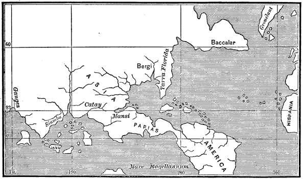
Orontius Fine's Map, 1531.
View larger image
All of the New World, so far as explored, is represented with tolerable accuracy, but the unexplored South Sea coast is made to extend westward from the region of Acapulco, and to join the southern coast of Asia, which is laid down from the ancient chronicles. Instead of being, as Stevens terms it, a "culmination of absurdities," I regard this map as more consistent with the knowledge of the time than any other printed during the first half of the sixteenth century. North America when found was regarded as Asia; South America was at first supposed to be a large island, and later an immense south-eastern extension of Asia; subsequent explorations, chiefly that of Magellan, showed the existence of a vast ocean between southern America and southern Asia; official maps left unexplored regions blank, expressing no theory as to the northern extension of the Pacific Ocean; other maps, as we have seen, without any authority whatever, make that ocean extend north and completely separate Asia from the New World. The present map, however, clings to the original idea and makes North America an eastern extension of Asia, giving the name America to the southern continent.
The map in the Basle edition of Grynæus, also given in Stevens' Notes, pl. iv. no. 4, closely resembles Schöner's Globe of 1520 (see page 137).
LOWER CALIFORNIA DISCOVERED.
[1533.] The expedition of Becerra, Grijalva, and Jimenez, sent out by Cortés to search for Hurtado de Mendoza and to continue north-western discoveries, sailed from Santiago in November. This voyage, like those following, will be fully treated elsewhere in this work. The only result, so far as the purposes of this chapter are concerned, was the discovery of the Revilla Gigedo group of islands and the southern part of the peninsula of Lower California, supposed then to be an island. Jimenez landed and was killed at Santa Cruz, now known as La Paz. The subsequent expedition of 1535-6, headed by Cortés in person, added only very slightly to geographical knowledge of the north-west. Many points were touched and named along the coast; but comparatively few can be definitely located except by the aid of information afforded by the earlier explorations of Guzman by land.
Schöner, Opvscvlvm Geographicvm, supposed to have been printed in 1533, maintains that the New World is part of Asia, and contains, so far as known, the first charge against Vespucci. Humboldt, Exam. Crit., tom. v. pp. 174-5. Other books of the year are: Franck, Weltbuch, Tübingen, 1533, which includes America in a description of the world; and Zummaraga, Botschafft des Grossmechtigsten Königs Dauid, n.p., n.d., containing a letter from Mexico dated in 1532.
[1534.] In 1534, 1535, and 1540, Jacques Cartier made three voyages for France, in which Newfoundland and the gulf and river of St Lawrence were carefully explored. Prima Relatione di Iacqves Carthier della Terra Nvova detta la Nuoua Francia, trouata nell'anno MDXXXIIII., in Ramusio, tom. iii. fol. 435; Hakluyt's Voy., vol. iii. pp. 201-36; Sammlung alter Reisebeschreibungen, tom. xv. p. 29.
Simon de Alcazaba sailed from San Lúcar in September, 1534, with two ships and 280 men, intending to conquer and settle the western coast of South America south of Peru. After spending a long time in the strait of Magellan, he was finally prevented by the mutiny of his men from proceeding farther. His explorations in the Patagonian regions were more extensive than had been made before. Seventy-five men, the remnant of his expedition, reached Española in September, 1535, one vessel having been wrecked on the coast of Brazil. Oviedo, Hist. Gen., tom. ii. pp. 155-65; Galvano's Discov., pp. 198-9; Herrera, dec. v. lib. vii. cap. v.; Diccionario Univ., app. tom. x. p. 807; Burney's Discov. South Sea, vol. i. p. 171.
The books of 1534 are, Francis of Bologna, La Letera, Venetia, n.d.; Chronica compendiosissima, Antwerp, 1534, containing letters from priests in Mexico; Vadianus, Epitome, Tigura, 1534, includes the Insulæ Oceani; Peter Martyr, Libro Primo Della Historia, Vinegia, 1534, which has joined to it a libro secondo by Oviedo, and an anonymous third book on the conquest of Peru; two anonymous works, Letera de la nobil cipta, and Copia delle Lettere del Prefetto della India, being letters from Peru, the latter describing the conquest; Honter, De cosmographiæ, Basileæ, 1534, with a chapter on the new islands; Xeres, Uerdadera relacion de la conquista del Peru, Seville, 1534; and an anonymous work on the same subject, La conquista del Peru, Seville, 1534.
[1535.] In this year appeared the first edition of the great historical work of Gonzalo Hernandez de Oviedo y Valdés, La Historia general de las Indias, Seville, 1535. Only nineteen of the fifty books which comprise the whole work appear in this edition; the work complete has since been published in Madrid, 1851-5. Steinhowel, Chronica Beschreibung, Franckenfort, 1535, has a chapter on 'America discovered in 1497.'
[1536.] In April, 1528, as we have seen, Pánfilo de Narvaez had landed on the west coast of Florida, probably at Tampa Bay, and attempted with three hundred men to reach Pánuco by land. The company gradually melted from famine, sickness, and battles with the savages, until only Alvar Nuñez Cabeza de Vaca with a few companions remained. They were held as slaves by the natives of the Gulf coast for six years; and then escaping, traversed Texas, Chihuahua, and Sonora, by a route which has not been very definitely fixed. Cabeza de Vaca with three companions reached the Spanish settlements in northern Sinaloa early in 1536, and their reports served as a powerful incentive to more extended exploration. Relatione che fece Alvaro Nvnez detto Capo di vacca, in Ramusio, tom. iii. fol. 310-30; Purchas, His Pilgrimes, vol. iv. p. 1499; Cabeça de Vaca's Relation, New York, 1871; Ternaux-Compans, Voy., série i. tom, vii.; Oviedo, Hist. Gen., tom. iii. p. 582 et seq.; Barcia, Historiadores Prim., tom. i.
Peter Martyr, De Rebus Oceanicis, Paris, 1536, contains nine decades. This work, with Sacro Bosco, Sphera Volgare, Venetiis, 1537, and Nunez, Tratado da Sfera, Olisipone, 1537, closes the bibliographical part of this Summary, in which, following Harrisse as the latest authority, I have endeavored to mention all the original works by which the geographical results of voyages of discovery were made known prior to 1540.
[1537.] After the abandonment of California by the colony, Cortés sent two vessels under Hernando de Grijalva and Alvarado (not Pedro) to Peru with supplies and reinforcements for Pizarro. There are vague reports that Grijalva sailed westward from Peru and made a long cruise in the Pacific, visiting various islands which cannot be located. Herrera, Hist. Gen., dec. v. lib. viii. cap. x.; dec. vii. lib. v. cap. ix.; Galvano's Discov., pp. 202-3; Burney's Discov. South Sea, vol. i. p. 180.
[1538.] Fernando de Soto landed on the west coast of Florida, crossed the peninsula to that part discovered by Aillon in 1526, wandered four or five years in the interior of the southern United States and followed the course of the Mississippi, probably as far up as to the Ohio. Here Soto died, and the remnant of his company, after penetrating farther west to the buffalo country, floated down the Mississippi and returned to Mexico in 1543. Soto's travels are esteemed by Kohl as "the principal source of knowledge regarding these regions, for more than a hundred years." Discov. and Conq. of Terra Florida, Hakluyt Soc., London, 1851; Selection of Curious Voy., Sup. to Hakluyt, London, 1812, p. 689; Purchas, His Pilgrimes, vol. iv. p. 1532; Ferdinands von Soto Reise nach Florida, in Sammlung, tom. xvi. p. 395.
[1539.] In August, 1539, three vessels under Alonso de Camargo were despatched from Seville for India via the South Sea, and reached Cabo de las Vírgenes January 20, 1540. One of the vessels was wrecked in the strait of Magellan; another returned to Spain, and the third entered the Pacific, and finally, after touching Chile in 38° 30', arrived at Arequipa in Peru. This voyage is supposed to have afforded the first knowledge of the intermediate coast between the strait of Magellan and Peru. Diccionario Univ., app. tom. x. p. 807; Herrera, Hist. Gen., dec. vii. lib. i. cap. viii.; Burney's Discov. South Sea, vol. i. p. 186.
NEW MEXICO INVADED.
Cabeza de Vaca brought to Sinaloa and thence to Mexico accounts of wonderful towns in the northern regions traversed by him; and in March, 1539, Fray Marcos de Niza, accompanied by one of the men who had seen the reported wonders, set out from Culiacan and proceeded northward in search of the Seven Cities of whose existence other rumors were current besides those brought by Alvar Nuñez. Marcos de Niza reached the Pueblo towns of Zuñi and brought back greatly exaggerated reports of the wealth of the people and the magnificence of their cities. Relatione del Reverendo Fra Marco da Nizza, in Ramusio, tom. iii. fol. 356; Purchas, His Pilgrimes, vol. iv. p. 1560; Pacheco and Cárdenas, Col. de Doc., tom. iii. p. 325; Hakluyt's Voy., vol. iii. pp. 366-73; Ternaux-Compans, Voy., série i. tom. ix. p. 256. See also Whipple, Ewbank, and Turner, in Pacific R. R. Reports, vol. iii. pp. 104-8.
Niza's report prompted Cortés to renewed efforts in his Californian enterprise, and in July, 1539, Francisco de Ulloa was sent from Acapulco with three vessels to prosecute the discoveries by water. Ulloa spent some time in the port of Santiago for repairs, lost one vessel in a gale near the entrance to the gulf, visited Santa Cruz, and then followed the main coast to the mouth of the Colorado, and returned along the coast of the Peninsula to Santa Cruz, where he arrived on the 18th of October. From this place he doubled the southern point of California, and sailed up the western coast to Cedros Island, and somewhat beyond. During the whole voyage he touched and named many places, whose names have seldom been retained, but some of which may be with tolerable certainty identified. In April the vessels separated, one returning by a quick passage to Colima. Ulloa himself with the other vessel attempted to continue his explorations northward, with what success is not known. According to Gomara and Bernal Diaz, he returned after several months spent in fruitless endeavors to reach more northern latitudes; other authorities state that he was never heard from. Preciado, who accompanied the expedition, wrote of it a detailed but not very clear narrative or journal. Relatione dello scoprimento che nel nome di Dio va à far l'armata dell' illustrissimo Fernando Cortese, etc. (Preciado's Relation), in Ramusio, tom. iii. 339-54, and in Hakluyt's Voy., vol. iii. pp. 397-424; Gomara, Hist. Conq., fol. 292-3; Bernal Diaz, Hist. Conq., fol. 234; Herrera, Hist. Gen., dec. vi. lib. ix. cap. viii. et seq.; Purchas, His Pilgrimes, vol. v. p. 856; Sutil y Mexicana, Viage, pp. xxii.-vi.; Burney's Discov. South Sea, vol. i. pp. 193-210; Venegas, Noticia de la California, quoted from Gomara, tom. i. pp. 159-61; Clavigero, Storia della California, tom. i. p. 151.
[1540.] Also in consequence of Marcos de Niza's reports, Francisco Vazquez de Coronado, who had succeeded Nuño de Guzman and Torre as governor of New Galicia, set out from Culiacan in April, 1540, penetrated to the Pueblo towns, or the Seven Cities of Cibola, and thence to the valley of the Rio Grande and far toward the north-east to Quivira, whose location, fixed by him in latitude 40°, has been a much disputed question. While in Sonora, he sent forth Melchor Diaz, who explored the head of the gulf, and the mouths of the rivers, Gila and Colorado, where he found letters left by Alarcon. See infra. From Cibola, Coronado sent Garcia Lopez de Cárdenas west, who passed through the Moqui towns and followed the Colorado for some distance. Coronado returned in 1542. Relatione che mando Francesco Vazquez di Coronado, in Ramusio, tom. iii. fol. 359; Pacheco and Cárdenas, Col. de Doc., tom. iii. p. 511. Hakluyt's Voy., vol. iii. pp. 373-82, has the same and Gomara's account. Ternaux-Compans, Voyages, série i. tom. ix., gives the relations of Coronado, Castañeda, and Jaramillo. See also Whipple, Ewbank, and Turner, in Pacific R. R. Reports, vol. iii. pp. 108-12; Simpson, in Report of Smithsonian Institution, 1869.
To coöperate with Coronado's land expedition, Hernando de Alarcon was despatched from Acapulco in May, 1540. Alarcon followed the coast to the head of the gulf, and ascended the Buena Guia (Colorado) some eighty-five leagues in boats, but hearing nothing from Coronado, he returned after burying letters, which, as we have seen, were found by Melchor Diaz. Beside the references given above, see Sutil y Mexicana, Viage, p. xxviii.; Burney's Discov. South Sea, vol. i. pp. 211-16; Purchas, His Pilgrimes, vol. iv. p. 1560; Schoolcraft's Arch., vol. iv. p. 21 et seq.; vol. vi. p. 60; Doc. Hist. Mex., serie iii. p. 671.
I here present reductions of two maps of the time to illustrate the explorations on the north-west coast, with which I close this sketch. The first was made by the pilot Castillo in 1541, and is taken from Cortés, Hist. Nueva-España, edited by Lorenzana, Mexico, 1770, p. 325.
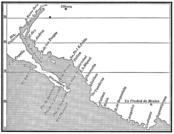
Castillo's Map, 1541.
View larger image
CALIFORNIA AND ARIZONA DISCOVERED.
A similar chart is mentioned by Señor Navarrete as existing in the hydrographic archives in Madrid. The second, from the Munich Atlas, no. vi., is of uncertain date. Peschel places it between 1532 and 1540; and it was certainly made about that time, as Yucatan is represented as an island, and California as a peninsula, although later it came again to be considered an island, as at its first discovery.
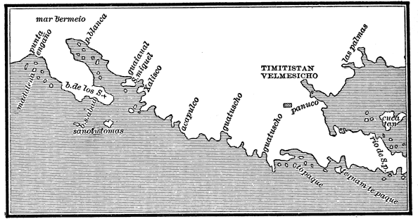
Manuscript Map, Author Unknown, Supposed to have been Drawn between 1532 And 1510.
View larger image
This, then, was Discovery. And in the progress of discovery we may trace the progress of mind. We can but wonder now, when we see our little earth belted with steam and lightning, how reluctantly the infant intellect left its cradle to examine its surroundings. Wrapped in its Mediterranean swaddlings, it crept forth timidly, tremblingly, slowly gaining courage with experience, until, throwing off impediments, it trod the earth in the fearless pride of manhood. Like all science, philosophy, and religion, cosmography was at first a superstition. Walled within narrow limits, as we have seen, by imaginary frost and fire, shaken from fear of heaven above and hell beneath, there is little wonder that the ancients dared not venture far from home; nor that, when men began to explore parts unknown, there should appear that romance of geography so fascinating to the Greek mind, that halo thrown by the dimness of time and distance over strange seas and lands. From this time to that of the adaptation of the magnet to purposes of navigation, about a score of centuries, there was little progress in discovery.
Is it not strange how the secrets of nature, one after another, reveal themselves according to man's necessities? Who would have looked for the deliverance of pent-up humanity from certain mysterious qualities in magnetic iron ore, which floated toward the north that side of a cork on which it was placed? When Vasco da Gama and Columbus almost simultaneously opened to Europe oceanic highways through which were destined to flow the treasures of the eastern and the western Indies, then it was that a new quality was discovered in the loadstone; for in addition to its power to take up iron, it was found to possess the rare virtue of drawing gold and silver from distant parts into the coffers of European princes; then it was that paths were marked out across the Sea of Darkness, and ships passed to and fro bearing the destroyers of nations, and laden with their spoils.