Volume 1 — CHAPTER I. INTRODUCTION. SPAIN AND CIVILIZATION AT THE BEGINNING OF THE SIXTEENTH CENTURY. (continued 3)
Reading edition
REAL AND IMAGINARY ISLANDS.
We have seen that, as a result either of the poetic fancy or of the actual discovery of the ancients, various islands were traditionally located in the Atlantic. Most of them undoubtedly owed their existence to the natural tendency of man to people unknown seas with fabulous lands and beings, "Il est si naturel à l'homme de rêver quelque chose au-delà de l'horizon visible," observes Humboldt. For a full account of the history and location of these islands, "dont la position est encore plus variable que le nom," and the important part played by them in ancient and middle-age geography, see Humboldt, Exam. Crit., tom. ii. pp. 156-245, and Kunstmann, Entdeckung Am., pp. 6 et seq., and 35-37. In the fifteenth century, with the revival of maritime enterprise, came a renewal and multiplication of the old fables. Monastic scholars, by their continued study of the old writers, by their attempts to reconcile ancient geography with fabulous events in the lives of the saints, and by their inevitable tendency to exaggeration, had contributed largely to their preservation. Still, throughout the preceding period, the belief in the existence of such islands had been vague and hypothetical; but when the actual existence of numerous islands in the western ocean was proved, and the Canary, Madeira, Azore, and Cape Verde groups were discovered and explored, the old ideas were naturally revived and confirmed, and with them rose a desire to rediscover all that had been known to the ancient voyagers. The reported wonders of the fabulous isles, having on them great and rich cities, were confidently sought in each newly found land, and not appearing in any of them, the islands themselves were successively located farther and farther to the west, out in the mysterious sea, to be surely brought to light by future explorations.
And of a truth, this wondrous western empire was subsequently brought to light; peoples and cities were found, but beyond the limits within which the wildest dreams of their discoverers had ever placed them. On this foundation not a few speculators build a theory that America was known to the ancients. The chief of the hypothetical isles were San Brandan, Antilia, and the Island of the Seven Cities; their existence was firmly believed in, and they were definitely located on maps of the period. San Brandan is said to have been visited by the saint whose name it bears in the sixth century. It was at first located far north and west of Ireland, but gradually moved southward until at the time of Columbus' first voyage it is found nearly in the latitude of Cape Verde. To the inflamed imagination mirage is solid earth, or sea, or a beautiful city; an island which was long supposed to be visible from Madeira and the Canaries had something to do with the location of this island of the saint, and of the others.
Antilia, and the Island of Seven Cities, according to Behaim's map, are identical. See page 93 this volume; also a reputed letter of Toscanelli, about the existence of which Humboldt thinks there may be some doubt. The only tangible point in the traditionary history is the migration of seven bishops, driven from the Peninsula by the Moorish invasion in the eighth century, who took refuge there and built the Seven Cities. The history and location of this Island of the Seven Cities in the fifteenth century are similar to those of San Brandan Island. Galvano says a Portuguese ship was there in 1447. Brazil, Bracie, or Berzil, was another of these wandering isles, whose name has been preserved and applied to a rock west of Ireland, to one of the Azore islands, and to a country in South America. This name has been the theme of much discussion, which, so far as I know, leads to no result beyond the fact that the name of a valuable dye-wood known to the ancients was afterward applied to lands known or conjectured to produce such woods. Humboldt, Exam. Crit., tom. ii. pp. 214-45; Kunstmann, Entdeckung Am., pp. 7-10, and 35 et seq. Kunstmann attaches greater geographical importance to the fabulous isles than Humboldt, connecting them in a manner apparently not quite clear to himself with the previous discoveries of the Northmen. Thus stood facts and fancies concerning the geography of the world, when the greatest of discoverers arose and achieved the greatest of discoveries.
Although in the chapters following I speak more at length of the deeds of the Genoese and his companions, yet in order to complete this Summary it is necessary to mention them here. I shall attempt no discussion concerning the country, family, date of birth, or early life of Christopher Columbus. For the differences of opinion on these points, with numerous references, see Harrisse, Bibliotheca Americana Vetustissima, New York, 1866, p. 2 et seq. Born somewhere in Italy, probably Genoa, about 1435, he received something more than a rudimentary education, went to sea at the early age of fourteen, and in 1470, which is about the date of his coming to Portugal, had already an extensive experience in the navigation of the Mediterranean, and was skilled in the theory as well as the practice of his profession. We have already seen him with the Portuguese on the African coast, and with the English in Iceland. In fact, before his first voyage westward in 1492, he was practically acquainted with all waters then navigated by Europeans.
The promptings which urged forward this navigator to the execution of his great enterprise may be stated as follows: The success of the Portuguese in long voyages down the African coast suggested to his mind, soon after 1470, that if they could sail so far south, another might sail west with the same facility and perhaps profit. Says his son: "Estando en Portugal, empeçó à congeturar, que del mismo modo que los Portugueses navegaron tan lejos al Mediodia, podria navegarse la buelta de Occidente, i hallar tierra en aquel viage." Colon, Hist. del Almirante, in Barcia, tom. i. p. 4; edition of Venetia, 1709, pp. 22-3; Humboldt, Exam. Crit., tom. i. p. 12; Navarrete, Col. de Viages, tom. i. p. lxxix; Herrera, Hist. Gen., dec. i. lib. i. cap. 1-7. His ardent imagination once seized with this idea, every nook and corner of geographical knowledge was searched for evidence to support his theory. By intercourse with other navigators he learned that at different times and places along the western coasts of Europe and Africa, objects apparently from unknown western lands had been washed ashore, suppositionally by the wind, really by the Gulf Stream or other oceanic currents. Humboldt, Exam. Crit., tom. ii. p. 249. Though well aware of existing rumors of islands seen at different times in the western ocean, it was not upon these, if any such there were, that he built his greatest anticipations of success. In the writings of the ancients he found another stimulant. Filled with fervent piety and superstitious credulity, he pored over every cosmographical work upon which he could lay his hands, as well the compilations of antiquated notions, such as the Imago Mundi of Pierre D'Ailly, or the more modern travels of Marco Polo and Sir John Mandeville. Colon, Hist. del Almirante, in Barcia, tom. i. p. 4 et seq.; Major's Prince Henry, pp. 349, 352; Humboldt, Exam. Crit., tom. i. pp. 46, 60; Kunstmann, Entdeckung Am., pp. 74-6.
EVOLUTION OF THE GRAND CONCEPTION.
The result of these studies was a complete acquaintance with the geographical knowledge of the day, with the greater part of what I have thus far epitomized, the doings of the Northmen excepted. From all this he knew of the earth's sphericity; he believed that the larger part of the world's surface was dry land; that the land known to Ptolemy extended over at least 180 degrees, or half the circumference of the globe, that is, from the Canaries to the Ganges; he knew that by later travels the eastern limit of geographical knowledge had been moved much farther east, even to Cathay; he believed that far out in the ocean lay the island of Zipangu; he knew that some eight or ten degrees had been added on the west by the discovery of the Azores; he believed that at most only one third of the circumference remained to be navigated; that this space might naturally contain some islands available as way stations in the voyage; that the explorations in the East were very indefinite, and consequently Asia might, and probably did, extend farther east than was supposed; that Ptolemy's figures were not undisputed—Marino making the distance from the Canaries to the Ganges 225 degrees instead of 180, while another geographer, Alfragano, by actual measurement, made each degree about one sixth smaller than Ptolemy, thus reducing the size of the earth, and with it the remaining distance to India; that several ancient writers—see quotations from Aristotle, Strabo, Seneca, et al., in Humboldt, Exam. Crit., tom. i. pp. 38, 61, 98 et seq.—had pronounced the distance to India very short, and had affirmed that it might be navigated in a few days; and finally that other scholars, as Toscanelli, had arrived at the same conclusions as himself, possibly before himself. Cartas de Pablo Toscanelli, Físico Florentin, á Cristobal Colon y al Canónigo Portugues Fernando Martinez, sobre el descubrimiento de las Indias, in Navarrete, tom. ii. pp. 1-4; Muñoz, Hist. Nuevo Mundo, pp. 48-9. See also, on Columbus' motives, Irving's Columbus, vol. i. pp. 42-51, and vol. ii. p. 148; Muñoz, Hist. Nuevo Mundo, pp. 45-7; Humboldt, Exam. Crit., tom. ii. pp. 324-9; Stevens' Notes, p. 28; Major's Prince Henry, pp. 347-52; Kunstmann, Entdeckung Am., p. 74. Many of these conclusions were erroneous, being founded on an incorrect idea of longitude; but this reduction of the earth's size was an error most fortunate for discovery, inasmuch as with a correct idea of the distance to be traversed, and with no suspicion of an intervening continent, such an expedition as that of the Genoese would not have been undertaken at the time.
Such were the ideas and aspirations of Columbus before his undertakings; later in life a theologic mysticism took possession of his mind, and his success was simply a fulfillment of divine prophecy in which cosmographical realities went for nothing. See Cartas de Don Cristobal Colon, in Navarrete, tom. i. p. 330.
All attempts to diminish the glory of Columbus' achievement by proving a previous discovery whose results were known to him have signally failed. The reports of mysterious maps which have been claimed to have prompted his enterprise evidently amount to nothing in view of the fact that Columbus never suspected the existence of any new countries, yet that he saw maps of the world, including the Asiatic coasts, can not be doubted. The case of the pilot Sanchez, said to have died in the house of Columbus, and to have told him of lands he had seen toward the west, if true, is likewise of little moment as touching the honor due to Columbus, for many men were confident of having seen such lands from the Canaries and other islands, and several voyages had been made in search of them, all of which was certainly known to Columbus. The story of Sanchez was started by Oviedo, who gives no authority or date for the event; it was repeated generally with disapproval by other historians, until revived by Garcilaso de la Vega with date and details; but his date, 1484, is ten years after Columbus is known to have proposed his scheme to the Portuguese government. Columbus originated no new theory respecting the earth's form or size, though a popular idea has always prevailed, notwithstanding the statements of the best writers to the contrary, that he is entitled to the glory of the theory as well as to that of the execution of the project. He was not in advance of his age, entertained no new theories, believed no more than did Prince Henry, his predecessor, or Toscanelli, his contemporary; nor was he the first to conceive the possibility of reaching the east by sailing west. He was however the first to act in accordance with existing beliefs. The Northmen in their voyages had entertained no ideas of a New World, or of an Asia to the west. To knowledge of theoretical geography, Columbus added the skill of a practical navigator, and the iron will to overcome obstacles. He sailed west, reached Asia as he believed, and proved old theories correct.
There seem to be two undecided points in that matter, neither of which can ever be settled. First, did his experience in the Portuguese voyages, the perusal of some old author, or a hint from one of the few men acquainted with old traditions, first suggest to Columbus his project? In the absence of sustaining proof, the statement of the son Fernando that the father should be credited with the reconception of the great idea, goes for little. Second, to what extent did his voyage to the north influence his plan? There is no evidence, but a strong probability, that he heard in that voyage of the existence of land in the west. It is hardly possible that no tradition of Markland and Vinland remained in Iceland, when but little more than a hundred years had passed since the last ship had returned from those countries, and when many persons must have been living who had been in Greenland. If such traditions did exist, Columbus certainly must have made himself acquainted with them. Still his visit to the north was in 1477, several years after the first formation of his plan, and any information gained at the time could only have been confirmatory rather than suggestive. Both Humboldt and Kunstmann think that even if he ever heard of the discoveries of the Northmen—which is thought probable by the latter—this knowledge would not have agreed with, nor encouraged, his plans. Kohl, Hist. Discov., pp. 115-20, believes that such a knowledge would have been the strongest possible confirmation of his idea of the nearness of Asia and Europe, in which opinion I concur. The idea of Draper, Hist. Int. Develop., p. 446, that had Columbus known of the northern discoveries he would have steered farther to the north, seems of no weight, since he sought not the northern but the southern parts of India.
FIRST VOYAGE OF COLUMBUS.
What Columbus had to contend with at this juncture was not, as I have said, old doctrines oppugnant to any new conception, but the ignorance of the masses, who held no doctrine beyond that of proximate sense, which spread out the earth's surface, so far as their dull conceptions could reach, in one universal flatness; and the knowledge of courts, whence alone the great discoverer could hope for support, was but little in advance of that of the people. Then the Church, with its usual firmness and conservatism, was against him. The monks, who were then the guardians of learning, knew, or might have known, all that Prince Henry, Columbus, and other earnest searchers had ascertained regarding the geography of the earth; but what were science and facts to them if they in any wise conflicted with the preconceived notions of the Fathers, or with Church dogmas? "II est vrai," says Humboldt, "que les scrupules théologiques de Lactance, de St. Chrysostôme et de quelques autres Pères de l'Eglise, contribuèrent à pousser l'esprit humain dans un mouvement rétrograde." And again, the African expeditions of the Portuguese had not on the whole been profitable or encouraging to other similar undertakings, and the financial condition of most European courts was not such as to warrant new expenses. Portugal, more advanced and in better condition to embark in new enterprises than any other nation, now regarded the opening of her route to India via the Cape of Good Hope an accomplished fact, and therefore looked coldly on any new venture. Nor were the extravagant demands of Columbus with respect to titles and authority over the new regions of Asia which he hoped to find, likely to inspire monarchs, jealous of their dignities, with favor toward a penniless, untitled adventurer. Passing as well the successive disappointments of Columbus in his weary efforts to obtain the assistance necessary to the accomplishment of his project, as his final success with Queen Isabella of Castile, let us resume our chronological summary.
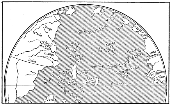
Martin Behaim's Globe, 1492.
View larger image
[1492.] Shortly before the sailing of Columbus, the learned astronomer Martin Behaim, of Nuremberg, constructed a globe showing the whole surface of the earth as understood by the best geographers of the time. This globe has been preserved, and I present a fac-simile of the American hemisphere published in Ghillany, Geschichte des Seefahrers Ritter Martin Behaim, Nürnberg, 1853. The entire globe may be seen in Jomard, Les Monuments de la Géographie, no. xv., Paris, 1854. A section of the globe is given by Irving, Columbus, vol. i. p. 53 (see also Id., p. 135), by London Geog. Soc. Journal, 1848, vol. xviii. p. 76; and a copy from Ghillany, with some of the names omitted, may be found in Kohl's Hist. Discov., p. 147, map no. iv.
The chart by which the voyage of Columbus was made is supposed to have been a copy of Behaim's Globe, which indeed may be regarded as the exponent of geographical conceptions, those of Columbus as well as those of the learned men and practical navigators of the day. By an inscription on the original, the Asiatic coast is known to have been laid down from Marco Polo, and to the islands of Antilia and San Brandan are joined other inscriptions giving their history as I have before indicated. Sailing from Palos on the 3d of August, 1492, with one hundred and twenty men in three vessels commanded by himself and the two brothers Pinzon, Columbus was at last fairly launched on the Sea of Darkness. After a detention of three weeks at the Canaries, he sailed thence the 6th of September; marked, not without alarm, the variation of the needle on the 30th of September; and on the 12th of October discovered San Salvador, or Cat Island.
So far all was well; all was as the bold navigator had anticipated; all accorded with current opinions, his own among the number; he had sailed certain days, had accomplished a certain distance, and had reached triumphantly one of the numerous islands mentioned by Marco Polo, and, God willing, would soon find the larger island of Zipangu. Alas for mathematical calculations, for that other third of the earth's circumference; alas for the intervening continent and broad Pacific sea, which baffled the great discoverer to the day of his death!
Passing over the cruise through the Bahamas, or Marco Polo's archipelago of seven thousand islands, in which the discoverers touched successively at Concepcion, Exuma (Fernandina), and Isla Larga (Isabela), we find Columbus sailing from the last-mentioned island on the 24th of October for Zipangu, with the intention of proceeding thence to the main-land, and presenting his credentials to the great Khan.
Touching at the Mucaras group, Columbus arrived at Zipangu, which was none other than the island of Cuba, on the 28th of October, and gave to the island, in place of its barbarous appellation, the more Christian name of Juana. Cruising along the northern shore of Cuba, in frequent converse with the natives, he soon learned that this was not Zipangu, was not even an island, but was the veritable Asiatic continent itself, for so his fervid mind interpreted the strange language of this people. Unfortunately he could not find the Khan; after diligent search he could find no great city, nor any imperial court, nor other display of oriental opulence such as were described by Marco Polo and Sir John Mandeville—only naked barbarians and thatched huts; so after advancing west beyond Savana la Mar, the discoverers returned to the eastern end of Cuba, visiting on the way the group El Jardin del Rey. Postponing the exploration of the coast toward the south-west, Columbus returned eastward and followed the northern coast of Española, turning off on his way to discover the Tortugas, and arriving at La Navidad, where he built a fort and left a colony of thirty-nine men. Now, Española, and not Cuba as he had at first supposed, was the true Zipangu; for the main-land of China could not by any possibility be the island of Japan; and in this belief Columbus sailed for Spain on the 16th of January, reaching the Azores on the 18th of February, and arriving at Palos the 15th of March, 1493. Primer viage de Colon, in Navarrete, tom. i. pp. 1-197; Purchas, His Pilgrimes, vol. i. booke ii. pp. 10-13; Sammlung aller Reisebeschreibungen, tom. xiii. p. 10; Napione and De Conti, Biografia Colombo, pp. 305-36; Peter Martyr, dec. i. cap. i.; Oviedo, Hist. Gen., tom. i. pp. 21-31, 46-55; Colon, Hist. del Almirante, in Barcia, tom. i. pp. 13-38; Irving's Columbus, vol. i. pp. 124-289; vol. iii. pp. 447-68; Major's Prince Henry, pp. 356-7; West-Indische Spieghel, p. 10; Cancellieri, Notizie di Colombo, pp. 66-76.
[1493.] Just before reaching the Azores, Columbus wrote on shipboard two letters describing his voyage, one under date of the 15th of February, and the other of the 14th of March. The manuscript of one, with copies printed in Spain probably during this same year, are yet preserved. Of the other, both the original manuscript and Spanish copies, if any were printed, are lost; but of a Latin translation, six editions are extant, supposed to have been printed in 1493, in France and in Italy, under the title Epistola Christofori Colom, or De Insulis Inventis, etc. A poetical paraphrase of the same letter appeared the same year as Dati, Questa e la Hystoria, etc., Florence, 1493, and four other works of this year contain slight allusions to Columbus. Seven or eight editions of Columbus' letters appeared in different forms during the next forty years. Both letters may be found with Spanish translations in the first volume of Navarrete's collection. For the bibliographical notices of this sketch I have depended chiefly on Harrisse, Bib. Am. Vet., as the latest and most complete essay on early American books, notwithstanding the few blunders that have subjected it to so much ridicule. I shall not consider it necessary to repeat the reference with each notice, as Harrisse's work is arranged chronologically.
PAPAL BULL OF PARTITION.
As soon as Columbus had explained to Ferdinand and Isabella the nature of his important discovery, the Spanish sovereigns applied to the Pope for the same grants and privileges respecting lands discovered, and to be discovered, in the west, that had before been granted the Portuguese in the south and east. His Holiness, accepting the Spanish statements that the concessions demanded did not in any way conflict with previous grants to the Portuguese, by bull of May 2, 1493, ceded to Spain all lands which might be discovered by her west of a line drawn from pole to pole, one hundred leagues west of the Azores; the Portuguese to have all new lands east of the same line. It is obvious that his Holiness fixed this line arbitrarily, without a thought of the position or importance of the corresponding meridian at the antipodes. This opposite meridian, according to the idea of longitude entertained at the time, would fall in the vicinity of India proper; and the Portuguese, besides their natural jealousy of this new success of Spain, feared that the western hemisphere thus given to her rival might include portions of their Indian grants. Hence arose much trouble in the few following years between the two courts. See infra.
Amidst the enthusiasm following his success Columbus had no difficulty in fitting out another expedition. Embarking from Cádiz September 25, 1493, with seventeen vessels and over 1,200 men, among whom were Alonso de Ojeda and Juan de la Cosa, el almirante, or the admiral, as Columbus was now called, touched at the Canaries, discovered Dominica the 3d of November, and Guadalupe a few days later; thence sailing north-west through the Caribbean Archipelago, he occasionally landed and gave names to islands. Resting two days at Puerto Rico, he reached the coast of Española on the 22d of November, and on the 27th anchored off the port of Navidad. The settlement established at this place in the previous voyage had totally disappeared; the colonists as is supposed falling victims to internal dissensions and general excesses. A new city called Isabela was then founded at another port of this island, and Ojeda was sent inland to explore the country. After a short absence he returned, reporting the country rich in gold. On the second of February, 1494, twelve vessels, with specimens of the people and products of the country, were despatched for Spain under Antonio de Torres. By this departure was also sent a request for immediate supplies. Recovering from a serious illness, Columbus checked a revolt among his people on the 24th of April, built a fort in the interior, and then sailed to explore the main coast of Asia—as he supposed, but in truth Cuba—south-westward from the point where he left it on his first voyage. Following the south coast of Cuba the admiral at length reached the vicinity of Philipina, or Cortés Bay, where the shore bends to the southward. This to him seemed conclusive proof that it was indeed the main-land of Asia which he was coasting. The statements of the natives who said that Cuba was in fact an island, but that it was so large that no one had ever reached its western extremity, confirmed him in his belief—since one might question the knowledge of a boundary which no one had ever reached and from which no one had ever come. The theory of the age was thus made good, and that was sufficient; so Columbus brought all his crew, officers and men, before the notary, and made them swear that the island of Cuba was the continent of Asia—an act significant of methods of conversion in those days. He even proposed to continue the voyage along the coast to the Red Sea, and thence home by way of the Mediterranean, or, better still, round the Cape of Good Hope, to meet and surprise the Portuguese; but his companions thought the supplies insufficient for so long a voyage, and the admiral was persuaded to postpone the attempt.
Returning therefore to Española, on the way back Columbus discovered and partially explored Jamaica, Isla de Pinos, and the small islands scattered to the southward of Cuba, arriving at Isabela on the 4th of September. There he found matters in a bad way. The colony, comprising a motley crew of lawless adventurers, ever ready to attribute success to themselves and ill-fortune to their governor, trumped up numerous complaints which caused the admiral no little trouble. Margarite, to whom had been given a command for an expedition inland, had revolted and sailed with several ships for Spain. Open war had been declared with the natives, and the colonists were hard pressed; but the admiral's presence and Ojeda's impetuous bravery soon secured order. Meanwhile two arrivals inspired the colonists with fresh courage; that of Bartolomé Colon, brother of the admiral, with three ships, and that of Torres, with four vessels laden with supplies. With the gold that had been accumulated, and specimens of fruits and plants, and five hundred natives as slaves, Torres was sent back to Spain, accompanied by Diego Colon, whose mission was to defend his brother's interests at court. The pacification of the natives was then completed, and heavy taxes were imposed upon them. In October, 1495, arrived Juan de Aguado, sent by the king to ascertain the facts concerning charges against the admiral. This man, in place of executing his commission fairly, only stirred up the accusers of Columbus to greater enmity—which quality of justice well accorded with the temper of his master Ferdinand. On account of these troubles, as well as from the discovery of a new gold mine, which proved beyond question that Española was the ancient Ophir of King Solomon, Columbus decided to return to Spain. So leaving his brother, Bartolomé, in command as adelantado, or lieutenant-governor, he sailed with Aguado, on the 10th of March, in two caravels, carrying 225 Spaniards and thirty natives. Touching at Marigalante, and Guadalupe, he arrived at Cádiz June 11, 1496. Segundo Viage de Cristobal Colon, in Navarrete, tom. i. pp. 198-241; Colon, Hist. del Almirante, in Barcia, tom. i. pp. 42-73; Peter Martyr, dec. i. cap. 2-4; Oviedo, Hist. Gen., tom. i. pp. 31-5; Napione and De Conti, Biografia Colombo, pp. 331-50; Irving's Columbus, vol. i. pp. 338-497; vol. ii. pp. 1-87; Major's Prince Henry, p. 358; Humboldt's Exam. Crit., tom. iv. p. 217; Cancellieri, Notizie di Colombo, pp. 93-9. The letters which Columbus sent to Spain by Torres in February, 1494, if ever printed, are lost; but in Syllacio, ad Sapiẽtissimũ ... de insulis, etc., Pavia, 1494 or 1495, appeared certain letters from Spain to the author of this work, describing the second voyage of Columbus.
[1494.] Thus during the absence of Columbus on his second voyage we have seen the ocean route between Spain and Española six times navigated; first, by the fleet of twelve vessels sent back to Spain by the admiral under Antonio de Torres; second, by Bartolomé Colon, who followed his brother to Española with three ships; third, by Margarite, who revolted and left Española during the absence of Columbus in Cuba; fourth, by Torres in command of four vessels from Spain with supplies for the colony; fifth, by the return of the same four ships to Spain with gold and slaves; and sixth, by Juan de Aguado with four ships from Spain in August, 1495.
REPARATION OF THE WORLD.
With the division of the world by Pope Alexander VI., Portugal was not satisfied. The world was thought to be not so large then as now, and one half of it was not enough for so small a kingdom which had boasted so great a navigator as Prince Henry. It was not their own side, but the other side, that troubled the Portuguese, fearing as they did that the opposite meridian threw into Spain's half a part or the whole of India. So Spain and Portugal fell to quarrelling over this partition by his Holiness; and the matter was referred to a commission, and finally settled by the treaty of Tordesillas in June, 1494, which moved the line 270 leagues farther west. About the location of this line of demarcation, and its effect on Brazil, and the Moluccas, much has been written, though little has been said as to the motive that prompted Portugal in making this change. The fact is, that at a time when the Spice Islands were but vaguely known, and the existence of Brazil not even suspected, it is impossible to conceive why Portugal desired to change the partition line from 100 leagues to 370 leagues west of the Azores; for the change could only diminish the possessions of Portugal in India by 270 leagues, as in truth it did, including the Moluccas in the loss, and gaining in return 270 leagues of open Atlantic sea! True, there proved to be an accidental gain of a part of Brazil, but there could have been no idea at the time that this partition line cut through any eastern portion of lands discovered by Columbus to the west. In whatever light we imagine them to have regarded it, there is still an unexplained mystery. The Pacific ocean was unknown; between the discoveries of Spain and Portugal, so far as known, all was land—India. By carrying the partition line westward, Portugal may have thought to find some western land; at all events, it is generally believed that the effect of the partition in the antipodes was not well considered; that the only point in question was the right of making discoveries in the western ocean, and that the treaty of Tordesillas was decided in favor of Spain—Portugal being forced to yield the main point, but insisting on the change of partition in order to give her more sea-room. On the other hand it may be claimed that the antipodes, of which they knew so little, were the avowed object of all the expeditions sent out by both parties. See the original bull and treaty in Navarrete, Col. de Viages, tom. ii. pp. 28, 130; also Prescott's Ferdinand and Isabella, vol. ii. pp. 173-83; Calvo, Recueil Complet des Traités, Paris, 1862, tom. i. pp. 1-36; Purchas, His Pilgrimes, vol. i. booke ii. pp. 13-15; Curious and Ent. Voy., p. 20; Cancellieri, Notizie di Colombo, p. 183.
Italy, and especially Venice, as we have seen, was the first of the European states to display in any marked degree in mediæval times that commercial spirit so early and so well developed in the Phœnicians. Portugal caught the flame under John the Great, 1385-1433, and led the van of a more daring discovery and exploration by conquests on the north-west coast of Africa. Simultaneously Prince Henry was sending expeditions farther down the western coast of Africa, and among the islands of the Atlantic. His country reaped the reward in 1486, when the discovery of the Cape of Good Hope opened her a way by sea to Hindostan, and to the commerce of the Orient, and gave at the same time the death-blow to Venetian ascendancy in that market.
But Spain, as chance would have it, did not lag far behind her sister kingdom. The fact of the great navigators, Columbus and Vespucci, being Italians, and yet having to seek assistance of Spain, sufficiently indicates in what direction the swing of maritime power was tending. The astronomical schools of Córdova, Seville, and Granada had well prepared Spain for the application of astronomy to navigation, and the long internal wars had bred those bold and enduring spirits who alone are fitted to conduct with success great enterprises of certain danger and uncertain result.
It is claimed by some that John and Sebastian Cabot made their first voyage and discovered Newfoundland in 1494. The claim rests on a statement of the Spanish ambassador to England in a letter dated July 25, 1498, to the effect that during the past seven years several vessels had been sent each year from Bristol in search of Brasil and the Islands of the Seven Cities, and on an inscription on Sebastian Cabot's map of 1544, which states that land was first discovered by the Cabots on June 24, 1494. D'Avesac, Letter on the Voyages of John and Sebastian Cabot, in Kohl, pp. 506-7. But other authors consider the map—even if made by Cabot, which is extremely doubtful—insufficient authority to prove such a voyage.
[1495.] At the solicitation of the brothers Pinzon and other navigators, a license was granted April 10, 1495, permitting any native-born Spaniard to make private voyages for trade and discovery from Cádiz to the Western India; such expeditions to be under the inspection of government, one of whose officials was to accompany each vessel to ensure the payment to the crown of one tenth of the profit of the voyage. For this document in full, see Navarrete, Col. de Viages, tom. ii. p. 165. See also Humboldt, Exam. Crit., tom. i. pp. 356 et seq. Whether any one actually took advantage of this license before its repeal—which was on June 2, 1497, at the instigation of Columbus—is a disputed point of some importance in connection with certain doubtful expeditions to be considered hereafter.
[1496.] Pedro Alonso Niño sailed from Cádiz June 17, 1496, just after the return of Columbus, in command of three vessels laden with supplies for the colony at Española.
AMERIGO VESPUCCI.
[1497.] Amerigo Vespucci, a Florentine navigator, claims to have set sail from Cádiz with four vessels in the service of the king of Spain on the tenth, or twentieth, of May, 1497. In what capacity he accompanied the expedition, or who was its commander, he does not state, but says that he was chosen by the king to go with the expedition. "Me ad talia investiganda in ipsam societatem elegit." Sailing south-south-west to the Canaries, 280 leagues from Lisbon, he remained there eight days, and then sailed west-one-quarter-south-west 1,000 leagues in twenty-seven, or thirty-seven, days, to a point on the main-land in 16° north and 75° west of the Canaries—that is to say, on the coast of Central America near Cape Gracias á Dios. This must have been about the 1st of July, some days perhaps after Cabot's landing farther north, which was the 24th of June. The Spaniards went ashore in boats, but the natives were too timid to trade; so that continuing their voyage for two days north-west in sight of the flat coast, they reached a more secure anchorage, established friendly relations with the people, and found some traces of gold. The ships then followed the coast for several days, to a port where was found a village built over the water like Venice, and there fought with the natives (of Tabasco?); sailed eighty leagues along the coast to a region of many rivers (Pánuco?), where they were kindly received by people of a different language, and made a journey of eighteen leagues inland, visiting many towns. This province was called by the inhabitants Lariab, and is situated in the torrid zone, near the tropic of Cancer, in 23° north. Again they started, pursued a north-west course and frequently anchored, sailing thus 870 leagues, until after thirteen months, that is to say in June, 1498, they reached "the best harbor in the world" (port of Cape Cañaveral?), in 28° 30', where they resolved to repair their ships for the return voyage. There they remained thirty-seven days, and when about to depart, the natives complained of certain cannibals who came each year from an island 100 leagues distant to attack them. The Spaniards, in return for their kindness, promised to avenge their wrongs. Accordingly they sailed north-east and east to a group of islands, some of which were inhabited (Bermudas?); landing at one of them called Ity, they defeated the cannibals, and made 250 prisoners, with a loss of one man killed and twenty-two wounded. Returning, they arrived at Cádiz October 15, 1499, with 222 prisoners, who were sold as slaves. The above is the account given by Vespucci in a letter written in 1504, according to the edition adopted as authentic and original by Varnhagen, Le premier Voyage de Amerigo Vespucci, who believes that Vicente Yañez Pinzon and Juan Diaz de Solis were the commanders. This voyage is not generally regarded as authentic; and a long and complicated discussion has arisen on the question whether the account given is to be regarded as true, as wholly a fabrication, or as belonging to a subsequent voyage and accidentally or intentionally dated back two years. As this voyage, if actually made as claimed by M. Varnhagen, would be the first to touch the territory which I denominate the Pacific States, I find it necessary to give in this place the leading points in the discussion. In what may be called the standard authorities on American discovery, such as Navarrete, Humboldt, and others, is found fully presented the question of the authenticity of Vespucci's voyage, always, however, under the supposition that the land claimed to have been visited was the coast of Paria. The theory of M. Varnhagen, that that region must be sought in North America, reopens the question and introduces some new features which cannot be passed by unnoticed in this connection. Without entering upon the somewhat complicated bibliography of Vespucci's narrations, or taking up the question of his claims in the matter of naming America, I shall attempt to state briefly, and as clearly as I am able, the arguments for and against the authenticity of a voyage, in which perhaps is involved the question of the first post-Scandinavian discovery of the North American continent.
THE DISPUTED VOYAGE OF VESPUCCI.
Besides Vespucci's own statement, in a letter written in 1504, no contemporary document has been found which mentions such an expedition, though most diligent search for such documents has been made in the Spanish archives by partisans and opponents of the Florentine's claim. This absence of confirmatory documents is the more noticeable as the expedition was made under royal patronage. In another and previously written letter describing his second voyage in 1499, Vespucci not only makes no mention of this voyage, but even excuses his long silence by saying that nothing had occurred worth relating. True, a short letter of one Vianello, dated 1506, published by Humboldt, mentions a voyage to which no date is given, made by Vespucci in company with Juan de la Cosa. M. Varnhagen supposes this to have been the voyage in question, and a large river discovered at the time to have been the Mississippi; but, beside the fact that there is no reason for attributing the date of 1497 rather than any other to this voyage, Vianello's letter, with two others, published by Harrisse, indicates a much later date for the expedition with Juan de la Cosa.
Moreover, not only is there a want of original records, but contemporary historians are silent respecting this expedition; the first mention by later writers being a denial of its authenticity when it was thought to conflict with the admiral's claims as discoverer of the continent. Yet, on the supposition of a voyage to the North American coast, there are some passages in the historians Peter Martyr, Oviedo, Gomara, and Herrera, which point more or less definitely to an exploration of the gulf of Honduras before 1502. Peter Martyr, dec. i. cap. vi., writing before 1508, says that many claim to have sailed round Cuba; and later, dec. i. cap. x., he mentions a report that Pinzon and Solis had explored the coast of Honduras, giving, however, no dates. Oviedo, Hist. Gen., tom. ii. p. 140, says positively that the gulf of Honduras was discovered not by Columbus, but by Pinzon and Solis, and that before the former discovered the Amazon, or the latter the Rio de la Plata, that is to say before 1499. Gomara, Hist. de las Indias, fol. 63, states that Pinzon and Solis are said by some to have explored the coast of Honduras three years before Columbus, which would make it in 1499. Herrera, Hist. Gen., dec. iv. lib. viii. cap. iii., says that the gulf of Honduras was named Hibueras from the gourds found floating in its waters by the first Spaniards who sailed along the coast. To M. Varnhagen, this it may be random remark of Herrera is proof positive that as Columbus did not enter or name the gulf, he was not the first Spaniard who sailed along the coast. Whatever weight may be attached to these passages from the historians, in proving a voyage to North America previous to that of the admiral, such evidence is manifestly increased by the fact that the date of the voyage attributed to Pinzon and Solis seems to rest entirely on the statement of Herrera, Hist. Gen., dec. i. lib. vi. cap. xvi., who describes the expedition with other events under the date of 1506. Yet in the testimony in the lawsuit hereinafter to be mentioned, it is implied, though not expressly stated, that the voyage was after that of Columbus, since special pains was taken by the king to prove the coast explored by Pinzon to be distinct from that discovered by the admiral. Another point is that in this same testimony the name 'Caria' is given to a place visited during Pinzon's voyage, and for this name Vespucci's 'Lariab' may possibly be a misprint.
Humboldt, Exam. Crit., tom. iv. pp. 59, 267, 272-4, repeatedly states it as an undeniable fact that Vespucci was employed in Spain in fitting out the vessels for the third voyage of Columbus, up to the date of the sailing of the expedition, May 30, 1498, and consequently could not himself have sailed in May or any other month of 1497. He makes this statement on the authority of documents collected by Muñoz. Harrisse, Bib. Am. Vet., p. 57, states, also on the authority of Muñoz, that from April, 1497, to May 30, 1498, Vespucci was "constantly travelling from Seville to San Lúcar." Vespucci is known to have succeeded Juanoto Berardi, who died in December, 1495, in a contract to fit out vessels for the Spanish government, and to have received money on account of that contract on the 12th of January, 1496. Irving, with access to the documents of Muñoz, says that four caravels fitted out by Vespucci sailed February 3, 1496, but were driven back; and he speaks of no evidence of his presence in Spain in 1497 or 1498. Navarrete, relying on the same Muñoz documents—which consist of extracts from the books of expenses of Indian armadas in the Casa de Contratacion in Seville—gives no date to the sailing and wreck of the four vessels mentioned by Irving, but implies that the event took place before Berardi's death. After speaking of the receipt of money on the 12th of January, 1496, he states that Vespucci "went on attending to everything until the armada was despatched from San Lúcar." Col. de Viages, tom. iii. p. 317. He does not state that the fleet thus fitted out was that in which Columbus sailed in 1498. Muñoz in the printed portion of his work is silent on the subject. Varnhagen, Vespuce et son Premier Voy., p. 18, argues that Humboldt had no authority whatever for applying Navarrete's statement respecting the armada despatched from San Lúcar to the admiral's fleet, that statement having probably been his authority, and not the original documents of Muñoz; and that the four vessels whose fitting-out Vespucci personally superintended were much more probably those in which he himself sailed and made the voyage in question. Varnhagen furthermore thinks that the death of Berardi furnished a reasonable motive for the resolution formed by Vespucci to visit the Indies, and a favorable opportunity for carrying out his resolution. If it can be proved that Vespucci was in Spain in 1497 and 1498, of course the question of his claimed voyage admits of no farther discussion; but if Humboldt's only authority be his interpretation of Navarrete's statement, even if the interpretation be not unnatural or improbable, the matter must still be considered doubtful until the original Muñoz documents are produced.
The silence of contemporary documents respecting Vespucci's voyage carries the greater weight from the fact that there are special reasons for the existence of such documents, if the voyage had been actually made. In 1508 a suit was begun by Diego Colon against the Spanish crown for the government of certain territory claimed by virtue of the discovery of Paria by his father, the admiral. The suit continued to 1513, and every effort was made by the crown to prove a previous discovery of the coast in question; hundreds of witnesses were examined, and their testimony has been preserved and published in Navarrete's collection. In this suit Vespucci was not summoned as a witness, although much of the time in royal employ, having held the office of piloto mayor from 1508 to his death in 1512. No claim was advanced for his discovery, although the voyage is stated to have been made under royal patronage, and by proving its authenticity the crown would have gained its object. Indeed, Vespucci's name is only mentioned once in all the testimony, and that as having accompanied Alonso de Ojeda in his voyage of 1499. That no one of the many witnesses examined knew of Vespucci's voyage in 1497, if it were a fact, is hardly possible. Not only were the witnesses silent on the Florentine's expedition, but many of them, including Ojeda, affirmed that Paria was first discovered by Columbus, and next afterward by Ojeda himself. Now as Vespucci accompanied Ojeda, the latter would surely have known of any previous discovery by Vespucci, and as Ojeda was not friendly to Columbus he certainly would have made the fact known. Moreover, the admiral's charts and sailing-directions were followed by Ojeda in his voyage, which would hardly have been done with a skilful pilot like Vespucci on board, and one who had visited the coast before. True, this last point would have little weight if the coast of Paria was not the region visited by Vespucci, while the other points would be little if at all affected by the theory that North America was the coast explored. No other Spanish voyage to the new region was neglected; indeed, to have so completely disregarded Vespucci's expedition, it must be supposed that the king not only knew exactly what region he explored, but had a positive conviction that said region was entirely distinct from Paria; and we have seen that no such definite opinion was held at the time, but on the contrary, special pains was taken to prove that the new regions were "all one coast." When it is considered that Vespucci's voyage, that is the voyage of Pinzon and Solis, was mentioned in the testimony, the failure to summon the piloto mayor appears all the more remarkable. What more efficient witness could have been brought forward? Thus the silence of the testimony in this suit on the question under discussion, must be deemed something more than mere negative proof, as it is termed by M. Varnhagen. This gentleman also notes that only one witness mentions that Vespucci accompanied Ojeda in 1499; but he does not note that the presence of Vespucci on Ojeda's ships was of no importance to either party in the suit, while a previous discovery by him was of the very greatest importance to the crown.
VESPUCCI'S VOYAGE FURTHER CONSIDERED.
The date of sailing from Cádiz is given by different editions of Vespucci's letter as May 10, and May 20, 1497; and of his return as October 1, 15, and 18, 1499. From these dates two difficulties arise; first, the duration of the voyage is stated in the letter to have been eighteen months, while the period between the dates of sailing and return is twenty-nine months; and again, Vespucci is known to have sailed with Ojeda in May, 1499, that is, five months before he returned from the voyage in question. One way of reconciling the first difficulty is to suppose that the author reckoned time by the Florentine method, then common in familiar correspondence, according to which the year began the 25th of March. Then in case of a very natural misprint in the original of May for March, the voyage really began in 1498, its duration being thus reduced to nineteen months. A more simple method of removing both difficulties is to suppose a misprint of 1499 for 1498 as the date of the return; this would reduce the time to seventeen months. Several later editions have made this change. The edition claimed as original by M. Varnhagen has the date 1499 according to his translation, and strangely enough the editor makes no allusion to it in his notes, although in a former pamphlet he speaks of 1498 as the date of the return. I attach very little weight to discrepancies in dates in this relation except as evidence against any intentional deception on the part of Vespucci. Confusion in dates is common in all relations of the period; and Vespucci's letters were written hastily, not for publication, and merely to interest his correspondents by a description of the marvels he had seen in his New World adventures. It may here be stated that the long and bitterly argued question of the rival claims of Vespucci and Columbus in the matter of naming America has no bearing on the present discussion. There is no evidence that the voyage in question had any influence in fixing the name America; and to pronounce this expedition not authentic has no tendency to weaken Vespucci's reputation for honesty, which may now be considered fully established; nor do the arguments against intentional falsification on Vespucci's part tend to prove the voyage authentic.
Several coincidences between the narratives of this voyage and that of Ojeda have led many writers to conclude that both describe the same expedition, the dates having been accidentally or intentionally changed. Humboldt, after a careful examination, was convinced that the two voyages were identical. But when we consider that Humboldt, Navarrete, and Irving formed their conclusions without a suspicion of a voyage to North America, and before that question had ever once arisen; that Navarrete severely criticises Vespucci's narrative as applied to Ojeda's voyage; that two of the strongest coincidences—the mention of Paria as the coast visited, and the discovery of a town built over the water like Venice—have no weight in view of the new theory, since the province is called Lariab in the original edition, and that method of building was not uncommon in all the tropical regions of America, it must be admitted that this argument has by itself little force against the authenticity of Vespucci's voyage.
The right granted to private individuals by the Spanish government in April, 1495, to make voyages of discovery at their own expense, subject to certain regulations, was partially revoked in June, 1497, after Vespucci's claimed departure. All authorities agree that during this time such private voyages, or even clandestine expeditions, may have been and probably were made, of which no records have been preserved. It is argued that Vespucci's voyage may have been of this number, although claimed to have been made under royal patronage, and by no means clandestine. It is even suggested that the revocation of the right of private navigation, brought about by the influence of Columbus, was purposely delayed until after Vespucci's departure—all of which proves, if it proves anything, simply that there was nothing to prevent Vespucci from making the voyage.
We have seen how certain statements of the old chroniclers may be taken as indicative of a voyage along the Central American coast previous to that of Columbus. There are also similar indications in some of the early maps. Thus Juan de la Cosa's map representing Cuba as an island in 1500 (see page 115 this volume) might be accounted for by such a voyage as Vespucci claims to have made. It will be seen hereafter that early maps show some slight traces of a knowledge of Florida before its discovery in 1512 (pp. 128-9 this vol.) In the Ruysch map of 1508 (p. 126 this vol.) the eastern coast of what seems to be Cuba is identified by M. Varnhagen with the main-land; in his opinion the inscription at the north point of that coast refers directly to Vespucci's expedition, and 'Cape S. Marci' at the southern point may indicate Vespucci's arrival on Saint Mark's day, especially as his uncle was a priest of the order of St Mark. If this appears somewhat far-fetched, perhaps more weight should be attached to the name 'Cape Doffin de Abril' on the southern point of what may be Florida on the Ptolemy map of 1513 (p. 130 this vol.), for at the end of April Vespucci may, according to his narrative, have been at that point. On this matter of an early voyage it may be noted that Columbus, striking the coast at Guanaja Island in 1502 in search of a passage westward, instead of following westward, as he naturally would have done, at least to the head of the gulf of Honduras, turned directly east. A knowledge on his part that Vespucci had already explored westward and northward without finding a passage, would account for his actions. But they have already been satisfactorily accounted for by the fact that he simply proposed to sail along the sinuosities of the supposed southern coasts of Asia to India, rather than to penetrate any intervening continent, whose existence he did not suspect.
CONCLUSIONS CONCERNING THE VOYAGE OF VESPUCCI.
In addition to the leading arguments for and against the voyage in question, the following minor points are urged:
It is claimed that the command of such an expedition would not have been given to a foreigner, and Vespucci did not become a naturalized citizen of Spain until 1505. But on the other hand, if Vespucci had rendered no other service to Spain than to have accompanied Ojeda, he would hardly have received so many favors from the government, especially after having served four years under the king of Portugal.
Señor Navarrete finds a difficulty in Vespucci's claim to have brought back to Spain 222 slaves in the few small vessels under his command. Vespucci also speaks of Ferdinand as king of Castile, which it was not customary to do until after Isabella's death.
The high opinion held of Vespucci during his life by Columbus and his zealous friends is of little weight, because the admiral's claim to have discovered the supposed Asiatic continent or islands adjacent thereto was undoubted; but the favorable opinions expressed by later writers, especially by Fernando Colon, writing after America was known to be distinct from Asia, tend to prove that the Florentine made in his lifetime no claim to a voyage in 1497. Yet the publication and circulation of his letter in several languages, uncontradicted for years, would indicate its authenticity, unless it be taken as a sign of carelessness for dates and details so long as they were not supposed to conflict with the admiral's claims. It must also be remembered that the same voyager's second, third, and fourth expeditions have all been disputed and have at last proved authentic.
M. Varnhagen applies to Vespucci and his men the well-known tradition related by Sahagun and others of white men who appeared at Pánuco from the east before the coming of the Spaniards. He also supposes Guerrero, the soldier found by Cortés at Cozumel, and believed by other authors to have been a survivor with Aguilar of Valdivia's shipwreck in 1512, to have been left in Yucatan by Vespucci; but he gives no reason for this belief, except that Guerrero had married among the natives, and had adopted many of their customs. By the same writer it is thought much more likely that Cape Gracias á Dios was named by Vespucci after a long voyage in search of land, than by Columbus after following the coast a few days and taking possession; especially as Columbus in his own letter simply mentions his arrival at the cape, the fact of his having given the name coming from other sources.
The events of the voyage, and the description of the coast visited by Vespucci as given in his letter, furnish no evidence whatever for or against the authenticity of the expedition; but if it be admitted from outside evidence that the voyage was actually made, and was distinct from that of Ojeda, while the narrative has nothing except the occurrence of the name Paria in favor of a South American destination, from it may be gathered the following points in support of the theory that a more northern coast was the one explored. The course sailed from the Canaries, W. ¼ SW.; the time thirty-seven days; the distance 1,000 leagues, taking the distance from Lisbon to the Canaries, 280 leagues, as a scale of measurement; the latitude of the landing 16°, and longitude 75° west of the Canaries; and the arrival by sailing up the coast at a province situated in about 23°, and near the tropic of Cancer, are worthy of consideration, since a series of blunders such as these is hardly probable. The natives of Lariab were of different language from and hostile to the nations passed further south, as the Huastecs of the Pánuco region are known to have been with respect to the Mexicans. Moreover, Lariab has a slight claim to being a Huastec word, since Orozco y Berra gives three names of places in that language containing an l and ending in ab; but of course this would interfere sadly with the theory that Lariab is a misprint of Caria. Vespucci's description of the natives, criticised by Navarrete as incorrect when applied to the people of Paria, agrees better, as M. Varnhagen thinks, with the aborigines of Honduras. Other parts of Vespucci's vague and rambling descriptions apply well enough to the North American coasts, or in fact to any part of tropical America, north or south.
The application of the narrative to North America is not, however, without its difficulties. Vespucci makes no mention of the Antilles, through which his course must have led him; perhaps not seeing them by reason of fog; or he had instructions not to concern himself with what the admiral had already discovered. He also refers to a larger work, never published, in which details were to be given. Neither does he mention the prominent peninsulas of Yucatan and Florida, nor the lofty mountain peaks which he would naturally have seen in following the Mexican coast. He claims to have sailed north-west from Pánuco 870 leagues (over dry land?) to the best harbor in the world. M. Varnhagen's explanation of this difficulty is that Vespucci simply states incidentally that he left Pánuco "tuttavia verso il Maestrale" still toward the north-west, not intending to include in this course the whole voyage of 870 leagues. All the windings of the coast and the entering and leaving of many ports or rivers must be taken into account to make up a distance of 870 leagues between Pánuco and Cape Cañaveral; and the latter port would hardly be considered the 'best harbor in the world' except by a great stretch of the imagination, or by a navigator little acquainted with good harbors. The archipelago of Ity has generally been supposed to be Hayti, but there is probably no reason for the identity beyond the resemblance of names. The Bermudas when discovered in 1522 were uninhabited, but this does not prove that they were always so; the Spaniards may have returned and captured the people for slaves. Indeed the Bermudas may have been the archipelago of San Bernardo, famous for its fierce Carib population, but generally located off the gulf of Urabá. It may even have been named by Vespucci, for on San Bernardo's day, the 20th of August, he was probably there.
Thus have I given, and let me hope without prejudice, the arguments for and against this disputed voyage; and from the evidence the reader may draw his own conclusions. To me the proofs seem conclusive that Vespucci made no voyage to South America prior to 1499, when he accompanied Alonso de Ojeda. Against a North American expedition the evidence, if less conclusive, is still very strong; since the most that can be claimed in its favor is a probability that the Central American coast was visited by some navigator before 1502, and a possibility, though certainly a very slim one, that Vespucci accompanied such navigation.
On this voyage see Navigationum Alberici Vesputii Epitome, in Grynæus, Novus Orbis, pp. 122, 155; Varnhagen, Le Premier Voyage de Vespucci; Id., Vespuce et son Prem. Voy.; also in Société Géog., Bulletin, Jan. and Feb., 1853; Harrisse, Bib. Am. Vet., pp. 58-68, and Additions, pp. xxvii-viii.; Lester and Foster's Life of Vespucius, pp. 93-139; Leben der See-Helden, p. 24; Navarrete, Col. de Viages, tom. iii. pp. 183-241, 291-3, 309-34; Irving's Columbus, vol. iii. pp. 395-418; Humboldt, Exam. Crit., tom. iv. v.; Major's Prince Henry, pp. 370-5; Kerr's Col. Voy., vol. iii. p. 342; Eerste Zee-Togt van Alonso D'Ojeda, en Amerikus Vesputius, in Gottfried, Reysen, tom. iii. p. 38; Cancellieri, Notizie di Colombo, pp. 41-7, 257.
CABOT AND VASCO DA GAMA.
[1497.] To continue our chronological summary. Following the brilliant success of Spain, England was the first nation to attempt discovery to the westward. Fully acquainted with the achievements and hypotheses of Columbus, having been indeed almost persuaded by him to embrace his beliefs, King Henry VII. on the 5th of March, 1496, granted a license to John Cabot, a Venetian citizen and trader of Bristol, to attempt discoveries in that direction.
Either from respect for Portuguese and Spanish rights in the south, or from some vague hints received from the Northmen during their trading voyages to Iceland, or possibly from a dim idea of the advantages of great-circle sailing, the English determined to attempt reaching India by a northern route. This expedition of Cabot's, with perhaps several vessels, sailed from Bristol probably in May, 1497; discovered land the 24th of June on the coast of Labrador between 56° and 58°; sailed some 300 leagues in a direction not known, but probably northward; and one vessel, the Matthew, returned to Bristol in August of the same year. No further details of the voyage are known, and those given, which are the conclusions of Humboldt, Kohl, and Stevens, have all been disputed in respect to date, commander, and point of landing. D'Avesac, as we have seen (pp. 98-9), insists on a previous voyage in 1494. Biddle, Memoir of Sebastian Cabot, London, 1831, p. 42 et seq., claims that Sebastian Cabot was the commander. Robinson, Account of Discov. in the West, Richmond, 1848, pp. 81-93, explains that by a change in the method of reckoning time after 1752, the date should properly read 1498. Many authors moreover confound this voyage with a later one. Hakluyt's Voy., vol. iii. pp. 4-11; Galvano's Discov., pp. 87-9; Viages Menores, in Navarrete, tom. iii. pp. 40-1. Irving, Columbus, vol. ii. p. 316, names but one voyage and regards the accounts as "vague and scanty." See also Humboldt, Exam. Crit., tom. i. pp. 279, 313; Hakluyt Soc., Divers Voy., pp. lxviii., 19-26; Kohl's Hist. Discov., pp. 121-35; Kunstmann, Entdeckung Am., pp. 48-53; Stevens' Notes, pp. 17-19; Pinkerton's Col. Voy., vol. xii. p. 158; Bancroft's Hist. U. S., vol. i. p. 13.
The Portuguese, to complete their discovery of the route to India by way of the Cape of Good Hope, sent out Vasco da Gama with four ships. Sailing from Lisbon July 8, 1497, he doubled the Cape of Good Hope the 22d of November, passed the limit reached by Dias on the 17th of December, received intelligence of Prester John at several points on the eastern coast, and anchored at Calicut May 20, 1498. Trading somewhat, jealous of everybody, after quarrelling with Arabian merchants and failing to make good his arbitrary measures, he thought best to return. Accordingly he set sail the 29th of August, passed the cape March 20, 1499, and reached Lisbon about the end of August. Thus Gama was the first to accomplish the grand object of so many efforts, and to reach India by water. His achievement would doubtless have been regarded as the most glorious on record, both to himself and to Portugal, had not Columbus for Spain reached the same continent, as he supposed, farther east several years before. Navigatione di Vasco di Gama, in Ramusio, tom. i. fol. 130; Galvano's Discov., pp. 93-4; Navarrete, Col. de Viages, tom. i. pp. xli.-ii.; Major's Prince Henry, pp. 391-406; Voyages, Curious and Entertaining, p. 103; Leben der See-Helden, p. 40; Notizie di Vasquez di Gama, in Cancellieri, Notizie, p. 165.
[1498.] After the return of the Cabots in August, 1497, with the news of having discovered the northern regions of Cathay, King Henry issued a new patent dated February 3, 1498, and, probably in May of the same year, two vessels with 300 men sailed from Bristol under command of Sebastian Cabot. Little is known of the voyage, save that he reached the coast of Labrador, which he followed northward until at a certain point where the coast trends eastward he found much ice even in July. This northern limit is placed by Ramusio at latitude 56°; by Gomara, who states that Cabot himself gives a much higher latitude, at 58°; by Galvano, at above 60°. Kohl follows Humboldt in the opinion that it was 67° 30', which would place it on the Cumberland peninsula. Cabot then turned southward and sailed as near shore as possible. The southern limit of this voyage is more indefinite than the northern. In a conversation with Peter Martyr, prior to 1515, Cabot stated that he reached the latitude of Gibraltar, and the chronicler adds that he sailed so far west that he had Cuba on his left. Cabot's remark would place him in latitude 36°, near Cape Hatteras, while Martyr's addition might apply to any locality on the east coast. Martyr's statement is the only authority for the supposition by Humboldt and others—see Exam. Crit., tom. i. p. 313, and Preface to Ghillany—that Cabot reached Florida. Stevens, Notes, pp. 17-19 and 35, considers Peter Martyr's remark as absurd, since it would place Cabot near Cincinnati. He is satisfied that the southern limit was the gulf of St Lawrence, founding this belief on maps of 1500 (see p. 115 this vol.) and 1508 (p. 126 this vol.), 1514, and 1544, the latter said to have been made by Cabot himself. That Cabot did not reach the southern coast of the United States seems proved by the fact that he was in Spain from 1513 to 1524, holding high positions, including that of piloto mayor, while that coast was actually being explored, and he making no claim to a previous discovery. The point reached, therefore, must remain undetermined between Cape Hatteras, where Kohl fixes it, and the gulf of St Lawrence, with a strong probability, as I think, in favor of the latter. Nothing whatever is known of the route or date of Cabot's return. And it is to be remembered that concerning this voyage we have only one contemporary document, which is a letter dated in 1498, stating simply that the expedition was still absent. All additional details are from accounts written after the geography of the New World was better known in consequence of the discovery of the South Sea. Nothing, then, can be proved by Cabot's voyages beyond the discovery of the continent in June, 1497, and the exploration of the coast from the gulf of St Lawrence to above 60° in 1498. The statement of Asher, Life of Henry Hudson, London, 1860, that Cabot "was the first to recognize that a new and unknown continent was lying as one vast barrier between western Europe and eastern Asia," accepted also by Kohl, Hist. Discov., p. 145, appears to me utterly without foundation. Cabot's complaint that a new-found land—that is a land further north and east than any part of Asia described by Polo—was a barrier to his reaching India, and the fact that on a map made as late as 1544, and doubtfully attributed to him, a separate continent is shown, seem weak authority for according him so important a discovery, especially when other voyagers and geographers, intimate with him and fully acquainted with his discoveries, continued for many years to join those discoveries to the Asiatic continent. See, beside references on page 107, Peter Martyr, dec. iii. cap. vi.; Gomara, Hist. Ind., fol. 31, 115; Robertson's Hist. Amer., book ix.; American Antiq. Soc., Transact., 1865, p. 25 et seq.; Kohl's Hist. Discov., pp. 135-46, 481; Stevens' Notes, pp. 35, 52; Kunstmann, Entdeckung Am., pp. 53-4.
THIRD VOYAGE OF COLUMBUS.
Returned from his second voyage, Columbus found his popularity waning, and with it the enthusiasm for new discoveries. The voyage had not been profitable, had not been fruitful enough in gold to satisfy the adventurers who accompanied him, and the ghastly faces of the mariners more than counteracted the effect of the specimens of native products exhibited. It was difficult, therefore, to obtain men for a new enterprise. Still, notwithstanding the reports of his numerous enemies, the admiral was considerately treated at court, and finally, by the efforts of the queen, six vessels were made ready, and Columbus embarked from San Lúcar on a third voyage May 30, 1498. This time he determined to steer farther to the south than before, in order to reach, as he supposed, the richer parts of Asia. After touching at Madeira, Porto Santo, and the Canaries, he divided his fleet, sent three vessels direct to Española, and with the other three reached the Cape Verde Islands the 27th of June. Thence he sailed first south-west and west through the region of tropical calms, and then northward to Trinidad Island, where he arrived the 31st of July. Coasting the island on the south, in sight of the main-land, he entered the gulf of Paria, landed, and found much gold of an inferior quality, and an abundance of pearls; from which circumstance, that land, which was the northern end of South America, was for some time thereafter known as the Pearl Coast. Passing out by the Boca del Drago on the 14th of August, he followed the northern coast of Paria to the island of Cubagua, beginning to suspect meanwhile that the land on his left was the main-land of Asia. Ill health and the state of his supplies did not permit him to satisfy himself on that point at the time, and consequently he turned his course north-west for Española. On the 30th of August he arrived at the mouth of the river Ozema, where he met his brother Bartolomé, who informed him of the internal discords and external wars of the colonists. Francisco Roldan had refused to submit to the admiral's authority, and on the 18th of October five ships were despatched for Spain with news of the rebellion. By this departure Columbus sent letters and charts describing this Pearl Coast, as his present South American discoveries which yielded so many gems were called. During the whole year following, peace was maintained among the colonists only by the most humiliating concessions of Columbus to Roldan and his crew. On the 5th of September, 1499, Alonso de Ojeda arrived at Española from the Pearl Coast, whither he had been to take advantage of the discoveries and misfortunes of the admiral.
Vessels laden with complaints by and against Columbus were despatched for Spain in October; needy, ambitious courtiers held King Ferdinand's willing ear against him; from his persistent advocacy of Indian slave-traffic the friendship of his patron, Queen Isabella, grew cold; and in July, 1500, Francisco de Bobadilla was sent to Española with powers to investigate. Arrived at Santo Domingo August 23, the commissioner assumed at once authority, which at most was his right only after careful and conscientious inquiry, seized Columbus and his brother, and in October sent them in irons to Spain. Colon, Hist. del Almirante, in Barcia, tom. i. pp. 74-99; Peter Martyr, dec. i. cap. vi.-vii.; Tercer Viage de Cristobal Colon, in Navarrete, tom. i. pp. 242-76; Napione and De Conti, Biografia di Colombo, pp. 350-75; Cancellieri, Notizie di Colombo, pp. 99-108, where is given Columbus' letter received in Spain in December, 1498, but apparently not printed at the time.
During this third voyage, while about the gulf of Paria, new visions of the earth's form filled the mind of the great navigator, inflamed as it was by illness and anxiety. The world was indeed for the most part spherical, as had been supposed, but in this great central region on the equator he believed the surface to rise gradually to a great height, making the earth pear-shape with the terrestrial paradise, or birth-place of man, on its apex, the waters and islands visited by him being on the borders of this elevated portion. It is not necessary to enumerate the natural phenomena, scientific writings, and scripture texts with which he confirmed his theory. In his distracted enthusiasm he leaves us somewhat uncertain as to his idea of the situation of this new region with respect to India proper and those parts of Asia found by him in a former voyage farther north. If he had supposed it to be simply a southern extension of Marco Polo's Asia, he would not subsequently have sought for a strait or passage to India to the north rather than to the south of this point. Gama's successful circumnavigation of Africa forbade a revival in the mind of Columbus of the old theory of Ptolemy, that Africa extended east and north so as to enclose the Indian Ocean like an immense gulf. The admiral's idea, so far as he formed a definite one on the subject, must have been that of a large island, or detached portion of the Asiatic continent, occupying very nearly the actual relative position of the Australian archipelago, and only vaguely included, if at all, in ancient or mediæval knowledge of the far East. No other conclusion could rationally be drawn from his letters and subsequent actions; and we shall find such an idea of the geography of these parts often repeated in following years. We shall also see how unfortunate it was for the posthumous glory of the great discoverer in the matter of naming the western world, that he did not more clearly specify his idea of this new land—for I believe this was the first suspicion that new lands of any considerable extent existed—and that his account of this and his fourth voyage were not more widely circulated in print.
[1499.] The discovery of the Pearl Coast, made known in Spain in December, 1498, caused several expeditions to be sent out in the following year. These were trading and not exploring voyages, and their commanders had no thought of cosmography, caring little whether Paria were the terrestrial paradise or the infernal regions, so that pearls, and gold, and slaves were abundant. No connected journals of these voyages have been preserved, our knowledge of them being derived from statements of the early historians and from testimony in the famous lawsuit with the heirs of Columbus, printed in Navarrete's collection.
MINOR EXPEDITIONS.
The first was that of Alonso de Ojeda, who, by the influence of Bishop Fonseca, the admiral's most bitter enemy, obtained a commission to visit the Pearl Coast, avoiding, however, lands discovered by the Portuguese and by Columbus prior to 1495. In company with Juan de la Cosa and Amerigo Vespucci, Ojeda embarked with four vessels from Santa María, near Cádiz, on the 20th of May, 1499. Sailing by the admiral's charts, he touched at the Canaries, and after twenty-four days reached the main-land of South America between 3° and 6° north latitude—that is according to Ojeda's testimony; but Vespucci's account of what was probably the same voyage brings them first upon the continent further south. This is claimed by Varnhagen, Examen de quelques points de l'histoire géographique du Brazil, Paris, 1858, as the first discovery of Brazil. Following the coast north-west for 200 leagues without landing, but discovering the two great rivers Essequebo and Orinoco, they landed on Trinidad Island, the first inhabited coast which they touched, where they traded for pearls and found traces of the admiral who had preceded them. Out through the Boca del Drago, following the coast of Paria to the gulf of Pearls, or Curiana, landing on Margarita Island, anchoring in the bay of Corsarios, they continued from port to port to Chichirivichi, where they had a fight with the natives, and spent twenty days in a port near by. Ojeda then visited Curazao and the gulf of Venezuela, where was found a town built over the water like Venice. On the 24th of August he discovered Lake Maracaibo, and afterward followed the coast westward to Cape de la Vela, whence he directed his course, on the 30th of August, to Española, arriving, as we have seen, September 5, 1499. He finally returned to Spain in the middle of June, 1500, the voyage having yielded but a small profit. Navarrete, Col. de Viages, tom. iii. pp. 4-11 and 543-5; Major's Prince Henry, pp. 367-9; Humboldt, Exam. Crit., tom. iv. pp. 195, 220; Oviedo, Hist. Gen., tom. i. p. 76.
The second minor expedition to South America was that of Pedro Alonso Niño and Cristóbal Guerra, similar in its object to that of Ojeda. A few days after Ojeda's departure they sailed from Palos in one vessel with thirty-three men, reaching the main-land farther north, and some fifteen days later than Ojeda. They traded on the coast of Cumaná for three months, their western limit being the region of Chichirivichi, started for home February 13, 1500, and arrived in Spain about the middle of April with a large quantity of pearls. Peter Martyr, dec. i. cap. viii.; Gomara, Hist. de las Indias, fol. 98; Navarrete, Col. de Viages, tom. ii. p. 147; tom. iii. pp. 11-18, 542; Irving's Columbus, vol. iii. p. 37-42; Humboldt, Exam. Crit., tom. iv. p. 220.
The third expedition of this year was that of Vicente Yañez Pinzon, who had commanded a vessel under Columbus in 1492. Sailing early in December, 1499, from Palos with a fleet of four vessels he crossed the equator, and on the 20th of January—Peter Martyr says the 26th, and Irving the 28th of January—discovered land in latitude 8° south, at Cape St Augustine, which he named Santa María de la Consolacion. Varnhagen, Examen, pp. 19-24, entertains doubts regarding the spot where Pinzon first landed, and thinks it quite as likely to have been some cape further north. From this point, wherever it may have been, Pinzon followed the coast to the north, touched at various places, discovered the Amazon, and in due time reached the gulf of Paria. Thence he sailed through the Boca del Drago, arrived at Española on the 23d of June, and returned to Spain in September, 1500. This voyage was as disastrous as the preceding one had been profitable. Peter Martyr states, dec. i. cap. ix., that Paria was thought to be a part of Asia beyond the Ganges. See also De Navigatione Pinzoni Socii Admirantis, et de rebus per eum repertis, in Grynæus, Novus Orbis, p. 119; Navarrete, Col. de Viages, tom. iii. pp. 18-23; Major's Prince Henry, p. 369; Humboldt, Exam. Crit., tom. i. pp. 313-14; tom. iii. p. 221.
Here belongs Amerigo Vespucci's account of a second voyage made in conjunction with others in the service of the king of Spain. Departing in May, 1499—some editions of his letters have it 1489—from Cádiz and touching at the Canaries he steered south-west for nineteen days, sailing in that time 500 leagues to a point on the main-land in latitude 5° south,—from incorrect readings of the originals some editors make him say 800 leagues and latitude 8°—where the days and nights are equal on the 27th of June, at which time the sun enters Cancer. Thence coasting eastward forty leagues; then north-west to a beautiful island and convenient harbor; and yet eighty other leagues to a secure harbor where he remained seventeen days and gathered many pearls; thence to another port; then to an island fifteen leagues from the main-land; and again to another island, which was called Gigantes, where captives were taken; then to a fine bay where the ships were refitted; and finally, after forty-seven days at this last place they sail for Antilla, that is Española. Two months and two days are spent at Antilla, whence on the 22d of July they embark for Spain, and reach Cádiz September 8, 1500. De Secundariæ Navigatinis Cursu, Latin text and Spanish translation of Vespucci's letter in Navarrete, Col. de Viages, tom. iii. pp. 242-62.
It has never been claimed that Vespucci attempted discoveries in 1499 as chief in command. The voyage described by him is without doubt that of Pinzon or Ojeda, although D'Avesac, in Bulletin de la Soc. Géog., makes it identical with that of Lepe. Humboldt, Exam. Crit., tom. iv. pp. 200 et seq., by comparing the details decides that it was that of Pinzon, and by the same method he concludes that Vespucci's first voyage was that under Ojeda. As the points of resemblance are slight in either case; as Vespucci is known to have accompanied Ojeda; as he would have been obliged to return to Spain before Ojeda in June, 1500, in order to sail with Pinzon in December, 1499; and as Vespucci describes an astronomical phenomenon which, as Humboldt admits, could not possibly have taken place during Pinzon's voyage, I am inclined to accept the generally received opinion that Ojeda's is the voyage described. "There can now be no doubt that Vespucci's voyage in 1499 was identical with that of Ojeda." Major's Prince Henry, p. 370; Varnhagen, Exam., pp. 1-19. Navarrete and Irving imply that this was the only voyage made by Vespucci for the crown of Spain. However it may be, for the purposes of this Summary the question is of little importance; for there are no disputed points of geographical import depending on the two trading voyages, one of which Vespucci attempts to describe; and if there were, his account in the different forms in which it exists is so full of blunders that it could throw but little light upon the subject.
LEPE, GUERRA, AND CABRAL.
The fourth minor expedition of this year was that of Diego de Lepe, who sailed in less than a month after Pinzon—that is near the end of December, 1499—with two vessels. Touching main-land below Cape St Augustine, he observed the south-western trend of the coast below that point; but of his voyage along the shore nothing is known save that he reached the Pearl Coast. Before the 5th of June he had returned to Spain. Navarrete, Col. de Viages, tom. iii. pp. 23-4, 553-5; Humboldt, Exam. Crit., tom. i. pp. 314-15; tom. iv. pp. 221-2.
There are some scattered hints collected in Biddle's Memoir of Sebastian Cabot, pp. 91 et seq., of a new expedition in 1499 by the Cabots, directed this time to tropical regions. They are not sufficient to render it probable that such a voyage was made, although Ojeda reported that he found several Englishmen cruising on the Pearl Coast. Viages Menores, in Navarrete, tom. iii. p. 41; Kohl's Hist. Discov., p. 145.
[1500.] In this year Cristóbal Guerra made a second voyage to the Pearl Coast with some success, and returned to Spain before November 1, 1501. Navarrete, Col. de Viages, tom. iii. pp. 24-5. Spain also made preparations to explore the northern lands discovered by the Cabots, but without any known results. Peschel, Geschichte der Entd., Stuttgart, 1858, p. 316; Navarrete, Col. de Viages, tom. iii. pp. 41-46; Biddle's Mem. Cabot, p. 236; Kohl's Hist. Discov., pp. 192-3. In Diccionario Universal, Apénd., article 'Viages,' p. 805, is mentioned a voyage to the Pearl Coast by Alonso Velez de Mendoza in two vessels. No authorities are given.
The year following the return of Gama from his successful voyage to India, Pedro Alvarez Cabral was entrusted with the command of thirteen well-armed vessels, and sent to establish commercial relations with the new countries now made accessible to Portuguese enterprise. Cabral embarked from Lisbon on the 9th of March, 1500; thirteen days later he left behind him the Cape Verde Islands, pursuing a south-westerly course. Whether he was driven by storms in this direction, or wished to avoid the calms of the Guinea coast, or whether he entertained a hope of reaching some part of the regions recently discovered by the Spaniards is not known. Certain it is, however, that notwithstanding his having sailed for India, on the 22d of April—Humboldt says in February—he found himself on the coast of Brazil in about latitude 10° south, leaving a gap probably of some 170 leagues between this point and the southern limit of Lepe and Pinzon. Thence he coasted southward, took formal possession of the land on the 1st of May at Porto Seguro, and named the country Vera Cruz, which name soon became Santa Cruz. Cabral immediately sent Gaspar de Lemos in one of the ships back to Portugal with an account and map of the new discoveries. Leaving two convicts with the natives of that coast, Cabral continued his journey for India on the 22d of May. Off the Cape of Good Hope he lost four vessels, in one of which was Bartolomeu Dias, the discoverer of the cape, and reached Calicut on the 13th of September. Returning he met at Cape Verde a fleet, on board of which is supposed to have been Amerigo Vespucci, and arrived at Lisbon July 23, 1501. Navigation del Capitano Pedro Alvares, in Ramusio, tom. i. fol. 132-9; Purchas, His Pilgrimes, vol. i. booke ii. pp. 30-1; Cancellieri, Notizie di Colombo, pp. 48-9; Navarrete, Col. de Viages, tom. iii. pp. 45-6, 94-101; Humboldt, Exam. Crit., tom. i. p. 315; tom. iv. p. 223; tom. v. pp. 53, 61.
The Portuguese did not overlook the north while making their important discoveries to the south. Two vessels, probably in the spring of 1500, were sent out under Gaspar Cortereal. No journal or chart of the voyage is now in existence, hence little is known of its object or results. Still more dim is a previous voyage ascribed by Cordeiro to João Vaz Cortereal, father of Gaspar, about the time of Kolno, which, as Kunstmann views it, "requires further proof." Touching at the Azores, Gaspar Cortereal, possibly following Cabot's charts, struck the coast of Newfoundland north of Cape Race, and sailing north discovered a land which he called Terra Verde, perhaps Greenland, but was stopped by ice at a river which he named Rio Nevado, whose location is unknown. Cortereal returned to Lisbon before the end of 1500. Cancellieri, Notizie di Colombo, pp. 48-9; Kunstmann, Entdeckung Am., p. 57; Galvano's Discov., pp. 95-6; Major's Prince Henry, p. 374; Kohl's Hist. Discov., pp. 166-8, 174-7. Biddle, Mem. Cabot, pp. 137-261, thinks that Cortereal landed south of Cape Race; Humboldt, Exam. Crit., tom. iv. p. 222, is of the opinion that Terra Verde was not Greenland.
In October of this same year Rodrigo de Bastidas sailed from Cádiz with two vessels. Touching the shore of South America near Isla Verde, which lies between Guadalupe and the main-land, he followed the coast westward to El Retrete, or perhaps Nombre de Dios, on the isthmus of Darien, in about 9° 30' north latitude. Returning, he was wrecked on Española toward the end of 1501, and reached Cádiz in September, 1502. This being the first authentic voyage by Europeans to the territory herein defined as the Pacific States, such incidents as are known will be given hereafter. For references to this voyage, see Oviedo, Hist. Gen., tom. i. p. 76; tom. ii. p. 334, where the date given is 1502; Gomara, Hist. Ind., fol. 67, date of voyage also 1502; Viages Menores, in Navarrete, tom. iii. pp. 25-8, 545-6; Herrera, Hist. Gen., dec. i. lib. iv. cap. xi.; Galvano's Discov., pp. 99-100, date of voyage 1503; Humboldt, Exam. Crit., tom. i. pp. 360-1; tom. iv. pp. 224; Voyages, Curious and Ent., p. 436; Churchill's Col. Voy., vol. viii. p. 375; Harris' Col. Voy., vol. i. p. 270; Major's Prince Henry, pp. 369-70; Asiento que hizo con sus Majestades Católicas Rodrigo de Bastidas, in Pacheco and Cárdenas, Col. Doc. Inéd., tom. ii. pp. 362-467; Robertson's Hist. Am., vol. i. p. 159; Quintana, Vidas de Españoles Célebres, 'Balboa,' p. 1.
EARLIEST EXISTING MAPS.
Of the many manuscript maps and charts made by navigators prior to this time none have been preserved. In the year 1500, however, a map of the world was made by the veteran pilot Juan de la Cosa, who had sailed with Columbus on his second voyage, and had accompanied Alonso de Ojeda to the Pearl Coast. It is preserved in the Royal Library of Madrid, and shows in a remarkably clear manner all discoveries up to that date. Drawn in colors and gold on ox-hide, on a scale of fifteen leagues to the degree, it lays down the parallels of Gibraltar and Paris, beside the equator and tropic of Cancer, and gives a scale at the top and bottom. Stevens' Notes, p. 16. Humboldt first published a copy of the American portion, and the whole, or parts thereof, have been since published or described in Lelewel, Géog. du moyen âge, tom. ii. pp. 109 et seq., atlas, no. 41; Sagra, Hist. physique et politique de l'île de Cuba, Paris, 1838, and atlas; Ghillany, Geschichte, etc., pref. by Humboldt; Jomard, Monuments de géog., atlas no. xvi., which gives a full-sized fac-simile; Kohl's Hist. Discov., pp. 151-5, 239, plate v., being a copy of the northern part from Humboldt with additions from Jomard. Stevens in his Notes, see pp. 11-16, 33, 51, and plate i., produces a photo-lithographic copy of the western hemisphere from Jomard. I give a copy of the central portions of the western hemisphere from Humboldt, Stevens, and Kohl.
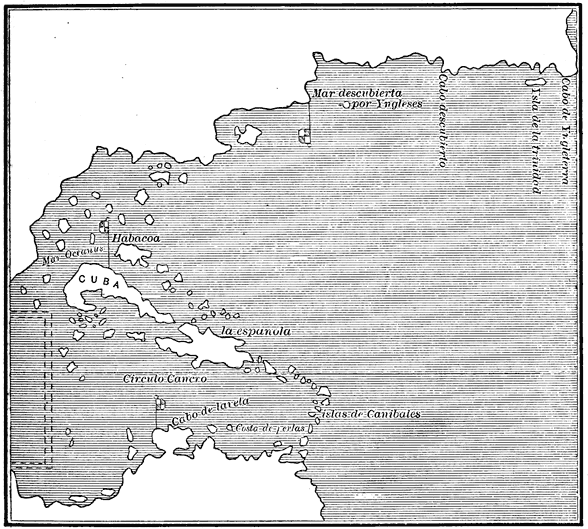
Juan de la Cosa's Map, 1500.
View larger image
The upper portion is North America, and the lower South America, between which a continuous coast line remains as yet undiscovered.
All the newly found regions are represented as parts of Asia, and consequently names are applied only to islands and particular localities. Up to this time three portions of the supposed Asiatic seaboard have been explored. First, there are the discoveries of the Cabots in the north, represented as extending from 'Cabo de Yngleterra' westward to the flag which bounds the 'Sea discovered by the English.' This direct western trend of the coast, most likely laid down from Cabot's charts, is one of the strongest evidences that the coast explored by Cabot was the northern shore of the gulf of St Lawrence. Another reason for entertaining such belief is the use of the words Mar descubierta por Yngleses instead of Mare Oceanus, thus indicating that it was a sea or gulf and not the open ocean. Cosa could not at the time have known the results of Cortereal's voyage. On Cabot's coast various points are named, but farther to the north-east and to the south-west the line is laid down indefinitely and without names, probably from Marco Polo. Kohl puts the inscription Mar descubierta, etc., farther south and west than on the original, and thinks the curve in the coast west of the last flag to be Cape Cod. Then we have in the south the northern coast of South America quite accurately laid down from Cape de la Vela south-eastward to the limit of Pinzon's voyage in 1499; with a nameless coast-line south-east to the locality of Cape St Augustine. From Cape de la Vela we have the same imaginary coast-line without names extending westward, as if to meet the line from the north-east; but just at the point where the lines must meet, or be separated by a strait leading to India proper, the non-committal map-maker inserted a picture—indicated by the double dotted lines—thus avoiding the expression of his opinion as to whether the Pearl Coast was joined to Asia, or was detached from the continent. On the original map no attempt is made to show inland topography, although the copies of Humboldt and Kohl have some lakes and rivers. I have taken the liberty to indicate the indefinite, nameless coasts by a dotted line for greater clearness. The last of the three several explored regions shown by this map are the central islands, Cuba, Española, and others discovered by Columbus, who was accompanied in at least one of his voyages by the author himself. In this part of the map some difficulty has arisen from the fact that Cuba is represented as an island, while Columbus is known to have held the opinion that it was a part of the mainland; an opinion, as before stated, which was subscribed to under oath by all his men, including Juan de la Cosa. On the original, the western part of Cuba is cut off by green paint, the conventional sign of terra incognita, which leads Stevens to infer that the pilot "did not intend to represent Cuba to be an island," but that he only supposed it to be such. This, however, by no means implies that the draughtsman intended to say that Cuba was not an island, but rather that he was not certain that it was an island, but only supposed it to be. It will be remembered that the natives affirmed from the first that it was an island, although so large that no one had ever reached its western extremity. This statement, together with his own observations during the voyage, probably caused Juan de la Cosa to afterward change the opinion to which he had perhaps hastily subscribed at the request of Columbus. There can be but little doubt of the authenticity of this map, although Stevens considers it has been distorted in the various copies and descriptions. That the author did not himself make any later additions to it is evident from the fact that his own subsequent discoveries are not shown.