Volume 1 — CHAPTER I. INTRODUCTION. SPAIN AND CIVILIZATION AT THE BEGINNING OF THE SIXTEENTH CENTURY. (continued 4)
Reading edition
[1501.] Again King Henry of England issues commissions permitting private persons to make discovery at their own expense. So far as known, however, no voyage was effected under this royal encouragement, although it is not improbable that intercourse with Newfoundland was continued after Cabot's discovery. Kunstmann, Entdeckung Am., p. 55; Kohl's Hist. Discov., pp. 185-7; Biddle's Mem. Cabot, p. 228 et seq.; Peschel, Geschichte der Entd., p. 334 et seq.
JUAN DE NOVA AND THE CORTEREALS.
The Portuguese, more practical in their attempts, push discovery in all directions. Juan de Nova with four vessels sails from Lisbon March 5, 1501, doubles the Cape of Good Hope, and returning reaches Lisbon September 11, 1502, having discovered Ascension Island on the voyage out, and St Helena on the return. Galvano's Discov., pp. 97-8; Major's Prince Henry, p. 413; Humboldt, Exam. Crit., tom. iv. p. 225; tom. v. p. 107. The Cape of Good Hope route to India may now be declared open; voyages thither from this time cannot properly be called voyages of discovery; hence of the frequent subsequent voyages of the Portuguese to India I shall make no mention except of such as in some way relate to America. For a summary of these later voyages see Major's Prince Henry, pp. 413-18.
Gaspar Cortereal this year makes a second voyage to the regions of the north, sailing from Belem, near Lisbon, May 15, 1501, with two or three vessels, touching probably at some point in Newfoundland, and coasting northward some six or seven hundred miles. He does not, however, reach the Terra Verde of the former voyage on account of ice. One of the vessels—Kunstmann says two—returned, arriving at Lisbon October 8, 1501; the other with the commander was never afterward heard from. One of the chief objects of this expedition seems to have been the capture of slaves. The name Labrador is applied by Cortereal to this discovery, "and is perhaps the only permanent trace of Portuguese adventure within the limits of North America." Bancroft's Hist. U. S., vol. i. p. 16; Navarrete, Col. de Viages, tom. iii. p. 44; Major's Prince Henry, p. 374; Humboldt, Exam. Crit., tom. iv. p. 224; Kohl's Hist. Discov., pp. 169-71; Peschel, Geschichte der Entd., pp. 331 et seq.; Biddle's Mem. Cabot, pp. 237 et seq.
The Portuguese also send an expedition to prosecute the discoveries begun by Cabral, who has not yet returned from India, but whose discovery of Brazil has been reported by Lemos. Strangely enough no documents exist in the Portuguese archives touching this voyage, nor is the name of its commander known, although Varnhagen thinks it may have been Manuel. It is known as Vespucci's third voyage, and its incidents are found only in his letters. The authenticity of this as of his other voyages has been often doubted and denied, and as it is the voyage that resulted in the naming of America, it has given rise to much discussion, into which however I shall not enter. The discussion does not affect the voyage itself, nor the leading facts connected with it, the questions being whether Vespucci was in command, which indeed he does not claim to have been; and above all, whether the results of the voyage entitled him to the honor of naming America, which they certainly did not, even had he commanded, from the fact that other navigators had discovered both of the Americas before him. Navarrete, one of Vespucci's most jealous enemies, admits that he visited the coast of Brazil in a subordinate capacity in some Portuguese expedition; and Humboldt, in an essay of 115 pages, effectually defends the veracity of Vespucci in his accounts of his voyages, which the distinguished commentator quotes with notes on the variations of different editions.
Vespucci was induced to leave Seville in order to accompany the fleet, which consisted of three vessels—some editions say ten, some fourteen—and which sailed from Lisbon on the 13th of May. Passing the Canaries without landing, to the African coast and Basilica in 14°, probably Cape Verde, there he remained eleven days. At this place he met Cabral's fleet returning from India and learned the particulars of the voyage, including the American discoveries, of which he gives a full account in a letter written at the time under date of June 4, 1501, which is a strong proof of the veracity of his other accounts. See extracts in Humboldt, Exam. Crit., tom. v. pp. 34-44. It is extraordinary that in the several accounts of this meeting the name of Vespucci's commander is not mentioned. From Cape Verde the fleet sailed south-west sixty-seven days and touched the main-land the 17th of August, at a point in 5° south latitude, taking possession for the king of Portugal. Thence it followed the coast south-east, doubled Cape St Augustine, and went on in sight of land for 600 leagues to a point in 32° south—according to Gomara, 40°; Navarrete thinks it could not have been over 26°. Having found no precious metals during a voyage of ten months, the Portuguese abandoned this coast on the 13th (or 15th) of February, 1502, and after having been driven by storms far to the south-east, and discovering some land whose identity is uncertain—Humboldt thinks it was an accumulation of ice, or the coast of Patagonia—they reached the coast of Ethiopia on the 10th of May, the Azores toward the end of July, and Lisbon September 7, 1502. Vespucci gives full descriptions of the natives of Brazil, but these descriptions, together with the numerous conflicting statements, or blunders of the various texts relating to details of the voyage, I pass over as unimportant to my purpose. That Vespucci was with a Portuguese fleet which in 1501-2 explored a large but ill-defined portion of the Brazilian coast, there can be no doubt. Grynæus, Novus Orbis, pp. 122-30; Ramusio, Viaggi, tom. i. pp. 139-44; Viages Menores, in Navarrete, tom. iii. pp. 46, 262-80; Humboldt, Exam. Crit., tom. v. pp. 1-115; Major's Prince Henry, pp. 375-7; Galvano's Discov., pp. 98-9.
[1502.] Miguel Cortereal sailed from Lisbon May 10, 1502, in search of his brother Gaspar, only to share his brother's fate. Neither of his two vessels appears to have returned. Viages Menores, in Navarrete, tom. iii. p. 44; Humboldt, Exam. Crit., tom. iv. p. 226; Major's Prince Henry, p. 374; Kohl's Hist. Discov., pp. 171-2.
It is probable that Portuguese fishermen continued their trips more or less to Labrador and Newfoundland, but if so, no accounts have been preserved. Kohl's Hist. Discov., pp. 187-92; Kunstmann, Entdeckung Am., pp. 69, 95; Herrera, Hist. Gen., dec. ii. lib. v. cap. iii.
In January, 1502, Alonso de Ojeda with four vessels departed from Cádiz on a second voyage to the Pearl Coast, with the intention of there establishing a colony. Accompanied by Garcia de Ocampo, Juan de Vergara, Hernando de Guevara, and his nephew Pedro de Ojeda, he touched at the Canaries and Cape Verde Islands, and reached the gulf of Paria. Refitting his vessels, on the 11th of March he set sail and coasted north-westward, touching at various points until he came to a port which he called Santa Cruz, probably Bahía Honda, about twenty-five miles east of Cape de la Vela. During the voyage along the coast the vessels were much of the time separated, following different courses. At Santa Cruz Ojeda found a man who had been left by Bastidas, and there he determined to establish his colony. A fort was built, and a vessel sent to Jamaica for supplies; but the colony did not prosper. To other troubles were added dissensions among the fiery leaders, and about the end of May Ojeda was imprisoned by his companions; the colony was finally abandoned, and its governor brought as a prisoner to Española in September. The few disputed points of this voyage concern only the personal quarrels of Ojeda and his fellow-captains. Navarrete, Col. de Viages, tom. iii. pp. 28-39, 168-70, 591 et seq.; Humboldt, Exam. Crit., tom. i. p. 360; tom. iv. p. 226.
FOURTH VOYAGE OF COLUMBUS.
On the eleventh of May, 1502, Columbus embarked from Cádiz on his fourth and last voyage. Refitting at Española, he directed his course westward, discovered terra firma at the Guanaja Islands, off the north coast of Honduras, and sailing southward, followed the shores of the supposed Asia to El Retrete on the isthmus of Darien, where terminated the discovery of Bastidas from the opposite direction, whose chart may have been in the admiral's possession. Particulars of this voyage are given hereafter. See Cuarto y Último Viage de Cristobal Colon, in Navarrete, tom. i. pp. 277-313; Colon, Hist. del Almirante, in Barcia, tom. i. pp. 101-18; Gomara, Hist. de las Indias, fol. 31; Peter Martyr, dec. iii. cap. iv.; Herrera, Hist. Gen., dec. i. lib. v.-vi.; Benzoni, Historia del Mondo Nvovo, Venetia, 1572, fol. 28; Galvano's Discov., pp. 100-1; Robertson's Hist. Am., vol. i. pp. 164-74; Burke's European Settlements in Am., vol. i. pp. 37-45; Napione and De Conti, Biografia Colombo, pp. 379-406; Laharpe, Abrégé, tom. ix. p. 122; Acosta, Comp. Histórico de la Nueva Granada, cap. i.; Navigatio Christophori Colvmbi, in Grynæus, Novus Orbis, p. 90, and elsewhere.
Since the admiral's discovery, in 1498, of the Pearl Coast, that is, the extreme northern shore of South America, nothing had occurred to modify his views formed at that time concerning the new regions, except to show that this southern addition of the Asiatic continent was much larger than had at first been supposed. His special aim in this fourth voyage was to do what various circumstances had prevented him from doing before, namely, to sail along the eastern and southern coasts of Asia to India, passing, of course, through the supposed strait between the main-land and the land of Paria. It is certainly extraordinary that this idea entertained by Columbus corresponded so closely with the actual conformation of the eastern Asiatic coast, and its southern addition of the Australian archipelago; that this conformation is so closely duplicated in the American coasts; and that the position of the admiral's hypothetical strait was almost identical with the actual narrowest part of the American continent. Columbus followed the coast to the western limit of Bastidas' voyage and could find no opening in the shore, either because the ancient chroniclers were faulty in making no mention of this great supposed southern extension of Asia, or because the strait had in some way escaped his scrutiny. He therefore abandoned the search, and gave himself up to other schemes, but he never relinquished his original idea, and died, 1506, in the belief that he had reached the coast of Asia, and without the suspicion of a new continent. Moreover, his belief was shared by all cosmographers and scholars of the time. Peter Martyr, dec. i. cap. viii.; Humboldt, Exam. Crit., tom. i. p. 26; tom. iv. p. 188; Preface to Ghillany; Major's Prince Henry, p. 420; Kohl's Hist. Discov., pp. 140, 238-9; Draper's Int. Develop., p. 445; Stevens' Notes, p. 37.
[1503.] Another expedition was sent by Portugal in search of the Cortereals, but returned unsuccessful. Kunstmann, Entdeckung Am., p. 58; Peschel, Geschichte der Entd., p. 334.
According to Harrisse, Bib. Am. Vet., pp. 173-4, we have "authentic deeds and depositions proving beyond doubt a French expedition to Brazil as early as 1503;" in support of which he refers to De Gonneville, Mémoires, Paris, 1663; De Brosses, Hist. des Navigations, Paris, 1756, tom. i. pp. 104-14; Revista Trimensal, Rio de Janeiro, tom. vi. p. 412-14; D'Avesac, in Bulletin de la Soc. Géog., tom. xiv. p. 172.
In 1503 the Portuguese sent a third fleet of six vessels under Gonzalo Coelho to make farther explorations on the coast of Brazil, then called Santa Cruz, and to sail, if possible, around its southern extremity to India, an idea that seems to have been conceived during the preceding voyage, but which could not then be carried into effect for want of supplies. Vespucci commanded one of the vessels, and set out with high hopes of accomplishing great things for his country, his God, and himself. This is known as Vespucci's fourth voyage. Beyond the account which he gives in his letters, little is known of it except the fact that Coelho made such a voyage at the time. The identity of the two expeditions has not been undisputed, but Humboldt and Major both show that there can be little doubt in the matter. The fleet sailed from Lisbon on the 10th of June—Vespucci says May—remained twelve or thirteen days at the Cape Verde Islands, and thence sailed south-east to within sight of Sierra Leone. The navigators were prevented by a storm from anchoring, and so directed their course south-west for 300 leagues to a desert island in about lat. 3° south, supposed to be Fernando de Noronha, where Coelho lost his ship on the 10th of August. Vespucci's vessel was separated from the rest for eight days, but afterward joined one of them, and the two sailed south-west for seventeen days, making 300 leagues, and arriving at the Bahía de Todos os Santos. Remaining there two months and four days, they followed the coast for 260 leagues to the port now called Cape Frio, where they built a fort and left twenty-four men who had belonged to the vessel which had been wrecked. In this port, which by Vespucci's observations was in lat. 18° south and 35° (or 57°) west of Lisbon, they remained five months, exploring the interior for forty leagues; they then loaded with Brazil-wood, and after a return voyage of seventy-seven days arrived in Lisbon June 28 (or 18), 1504. Vespucci believed the other ships of the fleet to have been lost, but after his account was written, Coelho returned with two ships; nothing, however, is now known of his movements after the separation. Di Amerigo Vespucci Fiorentino, in Ramusio, tom, i., Lettera prima, fol. 139, Lettera secondo, fol. 141, Sommario, fol. 141; Viages de Vespucio, in Navarrete, tom. iii. pp. 281-90; Southey's Hist. Brazil, vol. i. p. 20.
DIVERS EXPEDITIONS.
Alfonso de Alburquerque sailed from Lisbon April 6, 1503, with four vessels for India; but shaping his course far to the south-west, after twenty-four (or twenty-eight) days he reached an island previously discovered by Vespucci; thence he touched the main-land of Brazil, after which he proceeded around the Cape of Good Hope to India, and returned to Lisbon September 16, 1504. Viaggio fatto nell'India per Giovanni di Empoli, in Ramusio, tom. i. fol. 158; Purchas, His Pilgrimes, vol. i. pp. 32-3. Bergomas, Nouissime historiarũ omniũ, etc., Venetiis, 1503, a book of chronicles published with frequent additions to date, contains, for the first time, in this edition, a chapter on the newly found islands of Columbus. In my copy, which is dated ten years later, this chapter is on folio 328. At least nine editions of the work appeared before 1540.
[1504.] Soon after the return from his third voyage, Vespucci wrote a letter to Piero de' Medici, setting forth its incidents. This letter, which bears no date, was probably written in corrupt Italian, and after circulating to some extent in manuscript, as was the custom at the time, it may have been printed, but no copies are known to exist, and the original is lost. Translations were made, however, into Latin and German, which appeared in small pamphlet form in at least seventeen different editions before 1507, under the title of Mundus Novus, or its equivalent. The earliest edition which bears a date is that of 1504, but of the nine issues without date, some undoubtedly appeared before that year. It is probable that other editions have disappeared on account of their undurable form. None of Vespucci's other accounts are known to have been printed before 1507.
This same year the Libretto de tutta le Navigazione del Re di Spagna is said to have been printed at Venice, being the first collection of voyages, and containing, according to the few Italian authors who claim to have seen it, the first three voyages of Columbus and those of Niño and Pinzon. If authentic, it was the first account of the voyage of Columbus to the Pearl Coast; but no copy is known at present to exist, and its circulation must have been small compared with Vespucci's relations. Humboldt, Exam. Crit., tom. iv. pp. 67-77; Harrisse, Bib. Am. Vet., nos. 22-41.
A chart made about 1504 has been preserved which shows Portuguese discoveries only. In the north are laid down Newfoundland and Labrador under the name of 'Terra de Cortte Reall,' and Greenland with no name, but so correctly represented as to form a strong evidence that it was reached by Cortereal. On the south we have the coast of Brazil, to which no name is given; between the two is open sea, with no indication of Spanish discoveries. Kunstmann, Entdeckung Am., pp. 127-8, and Munich Atlas, no. iii.; Kohl's Hist. Discov., pp. 174-7, plate viii.
With the year 1504 the fishing voyages of the Bretons and Normans to Newfoundland are said to have begun, but there are no accounts of any particular voyage. Sobre las navegaciones de los vascongados á los mares de Terranova, in Navarrete, tom. iii. p. 176; Viages Menores, Id., p. 46. Kunstmann, Entdeckung Am., p. 69 et seq., makes these trips begin with Denys' in 1503.
Juan de la Cosa equipped and armed four vessels, and was despatched in the service of Queen Isabella of Spain, to explore and trade in the vicinity of the gulf of Urabá, and also to check rumored encroachments of the Portuguese in that direction. All that is recorded of the expedition is that in 1506 the crown received 491,708 maravedís as the royal share of the profits. Carta de Cristobal Guerra, in Navarrete, tom. ii. p. 293; Carta de la Reina, in Id., tom. iii. p. 109; Real Cédula, adicion, Id., p. 161. Stevens, in his Notes, p. 33, gives the date as 1505.
[1505.] Alonso de Ojeda, with three vessels, made a third voyage to Coquibacoa and the gulf of Urabá. Noticias biográficas del capitan Alonso Hojeda, in Navarrete, tom. iii. p. 169.
The letter written by Columbus from Jamaica July 7, 1503, describing the events of his fourth voyage, is preserved in the Spanish archives. If printed, no copies are known to exist, but an Italian translation appeared as Copia de la Lettera, Venetia, 1505.
A Portuguese map made about 1505 by Pedro Reinel shapes Newfoundland more accurately than the map of 1504, being the first to give the name 'C. Raso' to the south-east point; but Greenland is drawn much less correctly. Kunstmann, Entdeckung Am., pp. 125-7; Munich Atlas, no. i. Plate ix. in Kohl's Hist. Discov., pp. 177-9, differs materially from the fac-simile in the Munich Atlas. See also Peschel, Geschichte der Entd., p. 332; Schmeller, Ueber einigen der handschriftlichen Seekarten, in Akademie der Wissenschaften, Abhandl., tom. iv. pt. i. p. 247 et seq.
[1506.] The Bretons under Jean Denys are said to have explored the gulf of St Lawrence, and to have made a map which has not been found. The reports of this and of succeeding voyages northward are exceedingly vague. Charlevoix, Hist. de la Nouvelle France, Paris, 1744, tom. i. p. 4; Viages Menores, in Navarrete, tom. iii. p. 41; Kohl's Hist. Discov., pp. 201-5; Kunstmann, Entdeckung Am., p. 69; Bancroft's Hist. U. S., vol. i. p. 16.
Vicente Yañez Pinzon made a second voyage with Juan Diaz de Solis, in which he explored the gulf of Honduras, from the Guanaja Islands, the western limit of Columbus' voyage, to the islands of Caria on the coast of Yucatan, in search of the passage which was still believed to exist between the main continent of Asia and the land known as the Pearl Coast, Santa Cruz, or, in the Latin translations of Vespucci, as the Mundus Novus, or New World. Brief mention of this voyage may be found in Viages Menores, in Navarrete, tom. iii. p. 46, repeated in Irving's Columbus, vol. iii. p. 52; and Humboldt, Exam. Crit., tom. iv. p. 228. See also Reise des Diaz de Solis und Yanez Pinzon, in Sammlung aller Reisebeschreibungen, tom. xiii. p. 157.
Tristan da Cunha in a voyage to India, sailing from Lisbon March 6, 1506, round Cape St Augustine, heard of—eut connaissance de—a Rio São Sebastião in the province of Pernambuco, and discovered the island since called by his name, in 37° 5' south latitude, on his passage to the Cape of Good Hope. Galvano does not mention that Cunha reached America.
On the 20th of May, 1506, at Valladolid, died the great admiral of the Western Ocean, Christopher Columbus; whose story, notwithstanding his innumerable historians, is nowhere more fully comprehended than in the simple lines which may be seen to-day upon his tomb:
"Por Castilla y por Leon Nuevo Mundo halló Colon."
Maffei of Volterra, Commentariorum urbanorum, Rome, 1506, a kind of geographical encyclopædia, contains a section on the loca nuper reperta. Five editions are mentioned as having been issued in the years 1510, 1511, and 1530, all but one at Paris.
M. Varnhagen claims that the original mixed Italian text of Vespucci's first voyage was printed in Florence in 1505 or 1506, and that several copies have been preserved. This is the text used by him in his defense of Vespucci. See Premier Voy., Vienna, 1869, and Vespucci, son caractère, etc., Lima, 1865, in which the letter is reproduced. I find no mention by any other author of such an edition.
[1507.] No voyages are mentioned in this year; but the bibliography of the year is remarkable. Montalboddo (or Zorzi), Paesi Nouamente retrouati, Et Nouo Mondo da Alberico Vesputio, Florentino, intitulato, Vicentia, 1507, is the second collection of voyages issued, and the first of which any copies at present exist. This work is divided into six books, of which the fourth and fifth relate to America, the fourth being a reproduction of the Libretto of 1504, while the fifth is the Nouo Mondo, or third voyage of Vespucci; and its mention in the title shows how important a feature it was deemed in a work of this character. In the following year, besides a new Italian edition, there appeared a German translation under the title of Ruchamer, Newe unbekanthe landte, Nuremberg, 1508, and a Latin translation, Itinerariũ Portugallẽsiũ, Milan, 1508. At least fourteen editions in Italian, Latin, German, and French appeared before 1530.
THE NAMING OF AMERICA.
Hylacomylus (Waldsee-Müller), Cosmographiæ Introdvctio ... Insuper quatuor Americi Vespucij Nauigationes, Deodate (St Dié, Lorraine), 1507, is the title of a work which appeared four times in the same place and year. It is the first collection of Vespucci's four voyages, and generally regarded as the first edition of the first and fourth, although as we have seen M. Varnhagen claims an Italian edition of the first in 1506. This account of the third voyage is different from that so widely circulated before as Mundus Novus. Three other editions of the work, or of the part relating to Vespucci, appeared in 1509 and 1510. In Hylacomylus the following passage occurs: "But now that those parts have been more extensively examined, and another fourth part has been discovered by Americus (as will be seen in the sequel), I do not see why we should rightly refuse to name it America, namely, the land of Americus or America, after its discoverer, Americus, a man of sagacious mind, since both Europe and Asia took their names from women." Here we have the origin of the name 'America.' To the northern discoveries of Columbus, Cabot, and Cortereal, on the islands and coast of the supposed Asia, no general name was given because those regions were already named India, Cathay, Mangi, etc., while names were applied by Europeans only to particular places on the new coasts. When Columbus in 1498 explored the northern coast of South America he had no doubt it was a portion, though probably a detached portion, of Asia, and the terms Paria and the Pearl Coast sufficed to designate the region during the succeeding trading voyages. Concerning these voyages, only a letter of Columbus and a slight account of Pinzon's expedition had been printed, apparently without attracting much attention. The voyages of Columbus, Bastidas, and Pinzon along the coast of Central America were almost unknown. Meanwhile the fame of the great navigator had become much obscured. His enterprises on the supposed Asiatic coast had been unprofitable to Spain. The eyes of the world were now directed farther south. By the Portuguese the coasts of Brazil had been explored for a long distance, proving the great extent of this south-eastern portion of the supposed Asia, whose existence was not indicated on the old charts, and which certainly required a name. These Portuguese explorations and their results were known to the world almost exclusively by the letter of Vespucci so often printed. To the Latin translation of the letter, the name Mundus Novus had been applied, meaning not necessarily a new continent, but simply the newly found regions. The name 'America' suggested itself naturally, possibly through the influence of some friend who was an admirer of Vespucci, to the German professor of a university in Lorraine, as appropriate for the new region, and he accordingly proposed it. Having proposed it, his pride and that of his friends—a clique who had great influence over the productions of the German press at that period—was involved in securing its adoption. No open opposition seems to have been made, even by the Portuguese who had applied the name 'Santa Cruz' to the same region; still it was long before the new name replaced the old ones. In later years, when America was found to be joined to the northern continent, and all that great land to be entirely distinct from Asia, the name had become too firmly fixed to be easily changed, and no effort that we know of was made to change it. Later still some authors, inadvertently perhaps, attributed the first discovery to Vespucci. This aroused the wrath of Las Casas and others, and a discussion ensued which has lasted to the present time. See list of partisans on both sides in Harrisse, Bib. Am. Vet., pp. 65-7. Muñoz and Navarrete insist that Vespucci was an impostor, but others, headed by Humboldt, have proved conclusively that the name 'America' was adopted as the result of the somewhat strange combination of circumstances described, without any intentional wrong to Columbus. This conclusion is founded chiefly on the following reasons, namely: The honor to Vespucci resulted chiefly from his third voyage in 1501, and not from his first voyage in 1497, which last mentioned is the only one possible to have claimed precedence over Columbus in the discovery of the continent. Furthermore, neither Columbus nor Vespucci ever suspected that a new continent had been found; and to precede Cabot in reaching Asia, Vespucci, even if relying on his first voyage, must have dated it somewhat earlier in 1497 than he did; while to precede Columbus he must have dated it before 1492, when, as they both believed, Columbus had touched Asia at Cuba. Then, again, there is no evidence whatever that Vespucci ever claimed the honor of discovery. He was on intimate terms with the admiral and his friends, and is highly spoken of by all, especially by Fernando Colon, who was extremely jealous in every particular which might affect his father's honor. Moreover, it is certain that Vespucci did not himself propose the name 'America;' it is not certain that he even used the term Mundus Novus or its equivalent in his letters; and it is quite possible that he never even knew of his name being applied to the New World, since the name did not come into general use until many years after his death, which occurred in 1512. The most serious charge which in my opinion can be brought against Vespucci is neglect—perhaps an intentional deception for the purpose of giving himself temporary prominence in the eyes of his correspondent—in failing to name the commanders under whom he sailed; and with exaggeration and carelessness in his details. But it is to be remembered that his writings were simply letters to friends describing in familiar terms the wonders of his voyages, with little care for dry dates and names, reserving particulars for a large work which he had prepared, but which has never come to light. "After all," says Irving, "this is a question more of curiosity than of real moment ... about which grave men will continue to write weary volumes, until the subject acquires a fictitious importance from the mountain of controversy heaped upon it." Cancellieri, Notizie di Colombo, pp. 41-8; Humboldt, Exam. Crit., tom. iv. and v., and Preface to Ghillany; Navarrete, Col. de Viages, tom. i. p. cxxvi.; Major's Prince Henry, pp. 380-8; Kohl's Hist. Discov., p. 496; Harrisse, Bib. Am. Vet., pp. 65-6; D'Avesac, Martin Hylacomylus, Paris, 1867; Muñoz, Hist. Nuevo Mundo, p. x.; Stevens' Notes, pp. 24, 35, 52 et seq.; Viages de Vespucio, in Navarrete, tom. iii. p. 183; Carta del Excmo. Sr. Vizconde de Santarem, in Navarrete, tom. iii. pp. 309-34. Ludd, Speculi Orbis, Strasburg, 1507, adopts Waldsee-Müller's suggestion so far as to speak of the 'American race,' or people, gentis Americi. Major, Prince Henry, pp. 380-8, explains the connection between this and other works of the time influenced by the St Dié clique. See also Stevens' Notes, p. 35.
[1508.] Pinzon and Solis, with Pedro Ledesma as pilot, were sent by Spain for the third time to search southward for the strait which they, as well as Columbus and Bastidas, had failed to find farther north and west. Sailing from San Lúcar June 29, 1508, they touched at the Cape Verde Islands, proceeded to Cape St Augustine, and followed the coast south-west to about 40° south latitude, returning to Spain in October, 1509. Viages Menores, in Navarrete, tom. iii. p. 47. Kohl, Die beiden ältesten Karten von Am., p. 110, joins this voyage to the preceding one of 1506.
Another of the uncertain French voyages to Newfoundland is reported to have taken place in 1508, under the command of Thomas Aubert, from Dieppe. Viages Menores, in Navarrete, tom. iii. p. 41; Kohl's Hist. Discov., pp. 203-5.
In 1508 the governor of Española sent Sebastian de Ocampo to explore Cuba. He was the first to sail round the island, thus proving it such, as Juan de la Cosa probably imagined it to be eight years earlier. Aa, Naaukeurige Versameling, tom. vi. p. 1; Herrera, Hist. Gen., dec. i. lib. vii. cap. i.; Stevens' Notes, p. 35.
BOOKS AND MAPS OF THE PERIOD.
Ptolemy, In hoc opere hæc continentvr, Geographiæ Cl. Ptolemæi, Rome, 1508, is said to be the first edition of this work which contains allusions to the New World. Other editions of Ptolemy, prepared by different editors, with additional text and maps, and with some changes in original matter, appeared in 1511, 1512, 1513, 1519, 1520, 1522, 1525, 1532, and 1535. The edition first mentioned contains, in addition to the preceding one of 1507, fourteen leaves of text and an engraved map by Johann Ruysch—the first ever published which includes the New World. Copies have been printed by Lelewel in his Géog. du moyen âge, atlas; by Santarem, in his Recherches, Paris, 1842, atlas; and by Humboldt, Kohl, and Stevens. I have taken the annexed copy from the three last mentioned authorities, omitting some of the unimportant names.
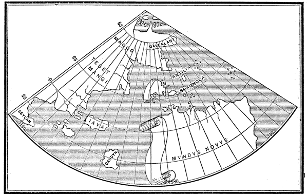
Map by Johann Ruysch, 1508.
View larger image
This map follows closely that of Juan de la Cosa in 1500, but illustrates more clearly the geographical idea of the time. The discoveries of Cabot, whom Ruysch is supposed to have accompanied, as well as those of Cortereal in the north, of Greenland, Labrador, and Newfoundland, are laid down with tolerable accuracy; and the rest of the supposed Asiatic coast as in Behaim's globe is taken from Marco Polo. In the centre we have the lands discovered by Columbus, and the old fabulous island of Antilia restored. To 'Spagnola' (Española) is joined an inscription stating the compiler's belief that it was identical with Zipangu, or Japan. Western Cuba is cut off by a scroll, instead of by green paint as in the map of Juan de la Cosa, with an inscription to the effect that this was the limit of Spanish exploration. Ruysch, having as yet no knowledge of Ocampo's voyage performed during this same year, evidently entertained the same idea respecting Cuba that was held by Juan de la Cosa, but did not venture to proclaim it an island. In the south, the New World is shown under the name 'Terra Sanctæ Crucis sive Mvndvs Novvs.' An open sea separates the New World from Asia, showing that Ruysch did not know of the unsuccessful search for this passage by Columbus, Bastidas, and Pinzon. It is worthy of remark that the name America is not used by this countryman of Hylacomylus. Humboldt thinks that he had not seen the Cosmographiæ Introdvctio, but had read some other edition of Vespucci's third voyage. Exam. Crit., tom. ii. pp. 5, 9; tom. iv. p. 121, and Preface to Ghillany. See also Kunstmann, Entdeckung Am., pp. 136-7; Harrisse, Bib. Am. Vet., pp. 107-8; Kohl's Hist. Discov., pp. 156-8; Stevens' Notes, pp. 31-2.
OCCUPATION OF TIERRA FIRME.
[1509.] Stimulated by the admiral's gold discoveries at Veragua, which had been corroborated by subsequent voyages. King Ferdinand of Spain determined to establish colonies on that coast. The region known as Tierra Firme was to that end divided into two provinces, of which Alonso de Ojeda was appointed governor of one, and Diego de Nicuesa of the other. Ojeda sailed from Española November 10, 1509, and Nicuesa soon followed. Their adventures form an important part of early Central American history, and are fully related in the following chapters. During the succeeding years frequent voyages were made back and forth between the new colonies, Jamaica, Cuba, and Española, which are for the most part omitted here as not constituting new discoveries. Peter Martyr, dec. ii. cap. i.; Gomara, Hist. Ind., fols. 67-9; Galvano's Discov., p. 109-10; Oviedo, Hist. Gen., tom. ii. pp. 421-8; Herrera, Hist. Gen., dec. i. cap. vii. lib. vii. et seq.
The Globus Mundi, Strasburg, 1509, an anonymous work, was the first to apply the name America to the southern continent. Humboldt, Exam. Crit., tom. iv. p. 142; Major's Prince Henry, p. 387.
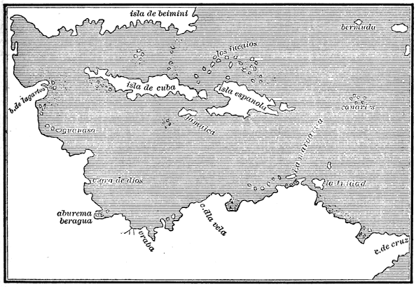
Peter Martyr's Map, 1511.
View larger image
[1511.] Juan de Agramonte received a commission from the Spanish government, and made arrangements to sail to Newfoundland and the lands of the north-western ocean, but nothing further is known of the matter. Viages Menores, in Navarrete, tom. iii. p. 42; Sobrecarta de la Reina Doña Juana, in Navarrete, tom. iii. p. 122. P. Martyris, Anglimediolanensis opera, Seville, 1511, is the first edition of Peter Martyr's first decade; containing in ten letters, or books, accounts of the first three voyages of Columbus, certain expeditions to the Pearl Coast, and closing with a brief mention of the admiral's fourth voyage. The learned author was personally acquainted with Columbus, and his relations are consequently of great value. This work contains a map, of which I give a copy from Stevens, the only fac-simile I have seen.
The map shows only Spanish discoveries, but it is by far the most accurate yet made. Cuba, now proved to be an island, is so laid down. No name is given to the Mundus Novus, which, by a knowledge of the Spanish voyages, is made to extend much farther north and west than in Ruysch's map; but above the known coasts a place is left open where the passage to India it was believed might yet be found. The representation of a country, corresponding with Florida, to the north of Cuba, under the name of 'Isla de Beimini,' may indicate that Florida had been reached either by Ocampo in 1508, by some private adventurer, as Diego Miruelo, who is said to have preceded Ponce de Leon, or, as is claimed by some, by Vespucci in his pretended voyage of 1497; but more probably this region was laid down from the older maps—see Behaim's map, p. 93—and the name was applied in accordance with the reports among the natives of a wonderful country or island, which they called bimini, situated in that direction. The map is not large enough to show exactly the relation which Peter Martyr supposed to exist between these regions and the rest of the world, but the text of the first decade leaves no doubt that he still believed them to be parts of Asia.
The Ptolemy of 1511 has a map which I have not seen, but which from certain descriptions resembles that of Ruysch, except that it represents Terra Corterealis as an island separated from the supposed Asiatic coast; the name Sanctæ Crucis for South America being still retained. As long as the new lands were believed to be a part of Asia, the maps bore some resemblance to the actual countries intended to be represented, but from the first dawning of an idea of separate lands we shall see the greatest confusion in the efforts of map-makers to depict the New World. Harrisse, Bib. Am. Vet., no. 68; Kunstmann, Entdeckung Am., 133; Kohl, Die beiden ältesten Karten von Am., p. 33. A copy of this map was published in Lelewel's Atlas.
[1512.] The West India Islands, in which the Spaniards are at length firmly established, become now the point of new departures. Conquerors and discoverers henceforth for the most part sail from Española or Cuba rather than from Spain. Juan Ponce de Leon, a wealthy citizen who had been governor of Puerto Rico, fitted out three vessels at his own expense, and sailed in search of a fountain, which according to the traditions of the natives had the property of restoring youth, and which was situated in the land called Bimini far to the north. This infatuation had been current in the Islands for several years, and, as we have seen, the name was applied to such a land on Peter Martyr's map of 1511. Sailing from Puerto Rico March 3, 1512, Ponce de Leon followed the northern coast of Española, and thence north-west through the Bahamas, reaching San Salvador on the 14th of March. Thirteen days thereafter he saw the coast of Florida, so named by him from the day of discovery, which was Pascua Florida, or Easter-day. The native name of the land was Cautio. On the 2d of April the Spaniards landed in 30° 8', and took possession for the king of Spain; then following the coast southward they doubled Cape Corrientes (Cañaveral) May 8, and advanced to an undetermined point on the southern or eastern coast, which Kohl thinks may have been Charlotte Bay. All this while they believed the country to be an island. On the 14th of June Ponce de Leon departed from Florida, and on his return touched at the Tortugas, at the Lucayos, at Bahama, and at San Salvador, arriving at Puerto Rico the 21st of September. He left behind one vessel under Juan Perez de Ortubia, who arrived a few days later with the news of having found Bimini, but no fountain of youth. Reise des Ponce de Leon, und Entdeckung von Florida, in Sammlung aller Reisebesch., tom. xiii. p. 188; Viages Menores, in Navarrete, tom. iii. pp. 50-3: Real cédula dando facultad á Francisco de Garay, in Navarrete, tom. iii. p. 148; Uitvoerlyke Scheepstogt door den Dapperen Jean Ponze de Leon gedaan naar Florida, in Gottfried, tom, iii.; Gomara, Hist. Ind., fols. 50-2; Galvano's Discov., p. 123. Kohl places the voyage in 1513, relying on Peschel, who, he says, has proved the year 1512 to be an impossible date.
In 1512 the Regidor Valdivia was sent by the colonists from the gulf of Darien, then called Urabá, to Española for supplies. Being wrecked in a violent tempest, he escaped in boats to the coast of Yucatan, where he and his companions were made captives by the natives. Some were sacrificed to the gods, and then eaten; only two, Gonzalo Guerrero and Gerónimo de Aguilar, survived their many hardships, the latter being rescued by Cortés in 1519. Torquemada, Monarq. Ind., tom. i. pp. 368-72; Gomara, Hist. Mex., fol. 21-2; Herrera, Hist. Gen., dec. ii. lib. iv. cap. vii.; Cogolludo, Hist. Yucathan, pp. 24-9.
The very rare map in Stobnicza's Ptolemy, Cracoviæ, 1512, I have not seen. It is said to show the New World as a continuous coast from 50° north latitude to 40° south. Neither in the text nor in the map is found the name America.
DISCOVERY OF THE PACIFIC OCEAN.
[1513.] In September, 1513, Vasco Nuñez de Balboa set out from the settlement of Antigua on the gulf of Urabá, and crossing the narrow isthmus which joins the two Americas, discovered a vast ocean to the southward on the other side of the supposed Asia. The Isthmus here runs east and west, and on either side, to the north and to the south are great oceans, which for a long time were called the North Sea and the South Sea. After exploring the neighboring coasts he returned to Antigua in January, 1514, after an absence of four months. Galvano's Discov., pp. 123-5; Peter Martyr, dec. iii. cap. i.; Oviedo, Hist. Gen., tom. iii. pp. 9-17; Andagoya's Narrative, p. 7; Carta del Adelantado Vasco Nuñez de Balboa, in Pacheco and Cárdenas, Col. Doc. Inéd., tom. ii. p. 526.
The Ptolemy of 1513 has a map which is said to have been made by Hylacomylus as early as 1508, but concerning which there seems to be much uncertainty. I give a copy from the fac-simile of Stevens and Varnhagen.
The name Cuba does not appear, and in its place is Isabela. Many of the names given by other maps to points on the coast of Cuba are transferred to the main-land opposite. The compiler evidently was undecided whether Cuba was a part of the Asiatic main or not, and therefore represented it in both ways. The coast line must be regarded as imaginary or taken from the old charts, unless, as M. Varnhagen thinks, Vespucci actually sailed along the Florida coast in 1497. This map if made in 1508 may be regarded as the first to join the southern continent, or Mundus Novus, to the main-land of Asia. This southern land is called 'Terra Incognita,' with an inscription stating expressly that it was discovered by Columbus, notwithstanding the fact that its supposed author proposed the name America in honor of Vespucci only the year before. In fact the map is in many respects incoherent, and is mentioned by most writers but vaguely. Harrisse, Bib. Am. Vet., no. 74; Humboldt, Exam. Crit., tom. iv. pp. 109 et seq., and Preface to Ghillany; Kunstmann, Entdeckung Am., pp. 130-2; Kohl, Die beiden ältesten Karten von Am., p. 33; Varnhagen, Nouvelles Recherches, Vienna, 1869, p. 56; Stevens' Notes, pl. ii. no. i. pp. 13, 14, 51; Major's Prince Henry, pp. 385-6; Santarem, in Bulletin de la Soc. Géog., May, 1847, pp. 318-23.
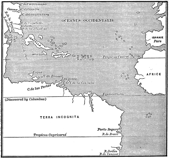
Map from Ptolemy, 1513.
View larger image
The name America is thought by Major to occur first on a manuscript map by Leonardo da Vinci, in the queen's collection at Windsor, to which he ascribes the date of 1513 or 1514.
[1514.] Pedrarias Dávila, having been appointed governor of Castilla del Oro, by which name the region about the isthmus of Darien was now called, sailed from San Lúcar with an armada of fifteen vessels and over 2000 men, April 12, 1514. The special object of this expedition was to discover and settle the shores of the South Sea, whose existence had been reported in Spain, but whose discovery by Vasco Nuñez de Balboa was not known before the departure of Pedrarias. Herrera, dec. i. lib. x. cap. xiii.; Peter Martyr, dec. ii. cap. vii.; dec. iii. cap. v.; Galvano's Discov., p. 125; Quintana, Vidas de Españoles Célebres, 'Balboa,' p. 28; Robertson's Hist. Am., vol. i. p. 207. See chapter x. of this volume.
[1515.] Juan Diaz de Solis sailed from Lepe October 8, 1515, with three vessels, and surveyed the eastern coast of South America from Cape San Roque to Rio Janeiro, where he was killed by the natives. Navarrete, Col. de Viages, tom. iii. pp. 48-50. Three vessels were fitted out at Seville, well manned and armed for a cruise against the Caribs, under command of Juan Ponce de Leon, but the Spaniards were defeated in their first encounter with the savages at Guadalupe, and the expedition was practically abandoned.
GRADUAL ENLARGEMENT OF THE TWO AMERICAS.
The adventures of Badajoz, Mercado, Morales, and others in 1515-16 and the following years, by which the geography of the Isthmus was more fully determined, are given elsewhere.
Schöner, Luculentissima quædã terræ totius descriptio, Nuremberg, 1515, and another edition of the same work under the title Orbis Typvs, same place and date, have a chapter on America 'discovered by Vespucci in 1497.' In Reisch, Margaritha Philosophica, Strasburg, 1515, an encyclopedia frequently republished, is a map which is almost an exact copy of that in the Ptolemy of 1513, except in its names. The main-land to the north-west of Cuba is called Zoana Mela, but the names of certain localities along the coast are omitted. Both Cuba and Española are called Isabela, and the southern continent is laid down as 'Paria seu Prisilia.' Harrisse, Bib. Am. Vet., nos. 80-2; Kunstmann, Entdeckung Am., pp. 130-1; Kohl, Die beiden ältesten Karten von Am., p. 33; Stevens' Notes, p. 52; fac-simile, pl. iv. no. 2.
[1516.] After Ponce de Leon's voyage in 1512 or 1513, and probably before that time, trips were made by private adventurers northward from Española and Cuba to the Islands and to Florida. Among these is that of Diego de Miruelo in 1516, who probably visited the western or gulf coast of Florida, and brought back specimens of gold. No details are known of the expedition. Garcilaso de la Vega, La Florida del Inca, Madrid, 1723, p. 5.
Lettera di Amerigo Vespucci, Florence, 1516, the second collection of the four voyages; Peter Martyr, Ioannes ruffus, De Orbe Decades, Alcala, 1516, the first edition of three decades; and Giustiniani, Psalterium, Genoa, 1516, which appends a life of Columbus to the nineteenth Psalm, are among the new books of the year.
[1517.] Eden, in his dedication of an English translation of Munster's Cosmography, in 1553, speaks of certain ships "furnished and set forth" in 1517 under Sebastian Cabot and Sir Thomas Pert; but so faint was the heart of the baronet that the voyage "toke none effect." On this authority some authors have ascribed a voyage to Cabot in 1517, to regions concerning which they do not agree. An expedition whose destination and results are unknown, can have had little effect on geographical knowledge; and Kohl, after a full discussion of the subject, seems to have proved against Biddle, its chief supporter, that there is not sufficient evidence of such a voyage. Navigatione di Sebastiano Cabota, in Ramusio, tom. ii. fol. 212; Kunstmann, Entdeckung Am., pp. 54-5; Roux de Rochelle, in Bulletin, Soc. Géog., Apr. 1832, p. 209; Peter Martyr, dec. iii. cap. vi.
Francisco Hernandez de Córdoba, with three vessels and 110 men, sailed from La Habana February 8, 1517, sent by the governor of Cuba to make explorations toward the west. Touching at Cape Catoche, in Yucatan, he coasted the peninsula in fifteen days to Campeche, and six days later reached Potonchan, or Champoton, where a battle was fought with the natives, and the Spaniards defeated. Accounts indicate that the explorers were not unanimous in supposing Yucatan to be an island, as it was afterward represented on some maps. Failing to procure a supply of water in the slough of Lagartos, Córdoba sailed across the Gulf to Florida, and thence returned to Cuba, where he died in ten days from his wounds. I find nothing to show what part of Florida he touched. Torquemada, Monarq. Ind., tom. i. pp. 349-51; Peter Martyr, dec. iv. cap. i.; Oviedo, Hist. Gen., tom. i. pp. 497-8; Galvano's Discov., pp. 130-1; Gomara, Conq. Mex., fol. 8-9; Herrera, Hist. Gen., dec. ii. lib. ii. cap. xvii.; Cogolludo, Hist. Yucathan, pp. 3-8; Prescott's Mex., vol. i. pp. 222-24; Viages Menores, in Navarrete, tom. iii. pp. 53-5; West-Indische Spieghel, p. 188; Icazbalceta, Col. Doc., tom. i. pp. 338-41.
[1518.] The following year Juan de Grijalva was sent from Cuba to carry on the explorations begun by Córdoba. Grijalva sailed from Santiago de Cuba April 8, 1518, with four vessels, reached the island of Santa Cruz (Cozumel) on the 3d of May, took possession on the 6th of May, and shortly after entered Ascension Bay. From this point he coasted Yucatan 270 leagues, by his estimate, to Puerto Deseado, entered and named the Rio de Grijalva (Tabasco), and took possession of the country in the vicinity of Vera Cruz about the 19th of June. Advancing up the coast to Cabo Rojo, he turned about and entered Rio Tonalá, engaged in a parting fight at Champoton, followed the coast for several weeks, and then turned for Cuba, arriving at Matanzas about the 1st of November. During his absence, Cristóbal de Olid had coasted a large part of Yucatan in search of Grijalva's fleet. Peter Martyr, dec. iv. cap. iii.-iv.; Torquemada, Monarq. Ind., tom. i. pp. 351-8, Oviedo, Hist. Gen., tom. i. pp. 502-37; Gomara, Conq. Mex., fol. 8-11, 56-8; Herrera, Hist. Gen., dec. ii. lib. iii. cap. i. ix.; Robertson's Hist. Am., vol. i. pp. 240-4; Brasseur de Bourbourg, Hist. Nat. Civ., tom. iv. pp. 40-50; Cogolludo, Hist. Yucathan, pp. 8-16; Diaz, Itinéraire, in Ternaux-Compans, Voy., série i. tom. x. pp. 1-47; Viages Menores, in Navarrete, tom. iii. pp. 53-64; Alaman, Disertaciones, tom. i. pp. 45-8; Reise des Johann Grijalva und allererste Entdeckung Neuspaniens, in Sammlung, tom. xiii. p. 258; Itinerario de Juan de Grijalva, in Icazbalceta, Col. Doc., tom. i. p. 281.
I may here remark that such manuscript maps, made generally by pilots for government use, as have been preserved are, as might be expected, far superior to those published in geographical works of the period. I give a copy of a Portuguese chart preserved in the Royal Academy at Munich.
From the fact that Yucatan is represented as a peninsula, though not named, while the discoveries of Grijalva and Cortés are not shown, the date of 1518 may be ascribed to the map. Stevens believes it to have been made some time about 1514; Kohl about 1520; Kunstmann some time after 1511. Unexplored coasts are left out instead of being laid down from old Asiatic maps; as for example the United States coast from Newfoundland (Bacalnaos) to Florida (Bimini), and the Gulf coast from Florida to Yucatan. In the central region the names 'Terram Antipodum' and 'Antilhas de Castela' are used without any means of deciding to exactly what parts they are to be applied. The South Sea discovered by Balboa in 1513 is here shown for the first time with the inscription 'Mar visto pelos Castelhanus.' To South America the name 'Brasill' is given. The presence of two Mahometan flags in locations corresponding to Honduras and Venezuela, shows that the compiler still had no doubt that he was mapping parts of Asia. Kunstmann, Entdeckung Am., pp. 129 et seq.; Munich Atlas, no. iv., from which I take my copy; Kohl's Hist. Discov., pp. 179-82, pl. x.; Stevens' Notes, pp. 17, 53, pl. v. Pomponius Mela's Libri de situ orbis, Vienna, 1518, contains a commentary by Vadianus, written however in 1512, in which the name America is used in speaking of the New World. Other editions appeared in 1522 and 1530.
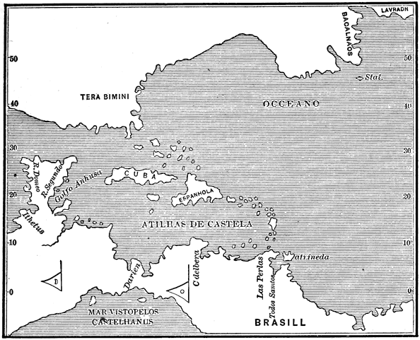
Map in Munich Atlas, supposed to have been Drawn about 1518.
View larger image
[1519.] Stobnicza's Ptolemy of 1519 alludes to the New World discovered by Vespucci and named after him.
Enciso, Suma de geografia, Seville, 1519, is the first Spanish work known which treats of the new regions. The author was a companion of Ojeda in his unfortunate attempt to found a colony on Tierra Firme. Another edition appeared in 1530.
CONQUEST OF MEXICO.
On February 18, 1519, Hernan Cortés set sail from Cuba to undertake the conquest of the countries discovered by Córdoba and Grijalva. After spending some time on the island of Cozumel, where he rescued Gerónimo de Aguilar from his long captivity (see p. 129), he followed the coast to Rio de Grijalva, where he defeated the natives in battle, and took possession of the land in the name of the Catholic sovereigns. From this place he continued his voyage sailing near the shore to Vera Cruz, where he landed his forces and began the conquest of Montezuma's empire, the history of which forms part of a subsequent volume of this series.
Francisco de Garay, governor of Jamaica, prompted by the reports of Ponce de Leon, Córdoba, and Grijalva, despatched four vessels in 1519, under Alonso Alvarez Pineda, who sailed northward to a point on the Pánuco coast (where, according to Gomara, an expedition had been sent during the preceding year, under Camargo). Prevented by winds and shoals from coasting northward as he desired, he sailed along in sight of the low gulf shores until he reached Vera Cruz, where he found the fleet of Cortés. Troubles between the commanders arose from this meeting which will be narrated hereafter.
Garay continued for some time his attempts to found a settlement in the region of Pánuco, but without success. Peter Martyr, dec. v. cap. i.; Gomara, Hist. Ind., fol. 55-6; West-Indische Spieghel, p. 202; Gomara, Hist. Conq., fol. 222-7; Viages Menores, in Navarrete, tom. iii. pp. 64-7; Kunstmann, Entdeckung Am., p. 73.
Soon after landing at Vera Cruz Cortés despatched for Spain a vessel under the pilot Antonio de Alaminos, with messengers who were to clear up before the king certain irregularities which the determined conqueror had felt obliged to commit, and furthermore to establish his authority upon a more defined basis. Alaminos sailed July 16, 1519, following a new route north of Cuba, through the Bahama Channel, and down the Gulf Stream, of which current he was probably the first to take advantage. Touching at Cuba and discovering Terceira he reached Spain in October. Diaz del Castillo, Hist. Verdadera de la Conqvista, Madrid, 1632, fol. 37-9; Herrera, Hist. Gen., dec. ii. lib. v. cap. xiv.; Kohl's Hist. Discov., pp. 243-5.
The history of the Darien colonies is elsewhere recounted in this volume, and the introduction here of the numerous land and water expeditions on and along the Isthmus would be confusing and unprofitable. Suffice it to say that in 1519 the city of Panamá was founded, and a second expedition sent under Gaspar de Espinosa up the South Sea coast. The northern limit reached was the gulf of San Lúcar (Nicoya), latitude 10° north, in Nicaragua, and the expedition returned to Panamá by land from Burica. Andagoya's Narrative of the Proceedings of Pedrarias Dávila, London, 1865, pp. 23-4; Kohl, Die beiden ältesten Karten von Am., p. 162; Oviedo, Hist Gen., tom. iii. p. 61 et seq.
We have seen several unsuccessful attempts by both Spaniards and Portuguese to find a passage to India by the southern parts of Brazil, Santa Cruz, or America. In 1519 a native of Oporto, Fernando de Magalhaens, called by Spaniards Magallanes, and by English authors Magellan, after having made several voyages for Portugal to India via Good Hope, quit the Portuguese service dissatisfied, entered the service of Spain, and undertook the oft-repeated attempt of reaching the east by sailing west. His particular destination was the Moluccas, which the Spaniards claimed as lying within the hemisphere granted to them by the treaty of Tordesillas in 1494. It appears that Magellan had seen some map, of unknown origin, on which was represented a strait instead of an open sea at the southern point of America—probably the conjecture of some geographer, for, says Humboldt, "dans le moyen âge les conjectures étaient inscrits religieusement sur les cartes." See Exam. Crit., tom. i. pp. 306, 326, 354; tom. ii. pp. 17-26. Sailing from San Lúcar September 20, 1519, with five ships and 265 men, he reached Rio de Janeiro on the coast of Brazil on the 13th of December, and from that point coasted southward. An attempt to pass through the continent by the Rio de la Plata failed, and on March 31, 1520, the fleet reached Port St Julian in about 49° south, where it remained five months until the 24th of August. On the 21st of October Magellan arrived at Cabo de las Vírgenes and the entrance to what seemed, and indeed proved, to be the long-desired strait. Having lost one vessel on the eastern coast, and being deserted by another which turned back and sailed for Spain after having entered the strait, with the remaining three he passed on, naming the land on the south Tierra del Fuego, from the fires seen burning there. Emerging from the strait, which he called Vitoria after one of his ships, on the 27th of November he entered and named the Pacific Ocean. Then steering north-west for warmer climes he crossed the line February 13, 1521, arrived at the Ladrones on the 6th of March, and at the Philippines on the 16th of March. This bold navigator, "second only to Columbus in the history of nautical exploration," was killed on the 27th of April, in a battle with the natives of one of these islands; the remainder of the force, consisting of 115 men under Caraballo, proceeded on their way, touching at Borneo and other islands, and anchoring on the 8th of November at the Moluccas, their destination. From this point one of the vessels, the Vitoria, in command of Sebastian del Cano, sailed round the Cape of Good Hope, and reached San Lúcar September 6, 1522, with only eighteen survivors of the 265 who had sailed with Magellan. Thus was accomplished the first circumnavigation of the globe.
THE NAMING OF THE PACIFIC OCEAN.
As to the circumstances attending the naming of the Pacific Ocean, a few words may not be out of place. Magellan was accompanied by one Antonio Pigafetta, of Vicenza, afterward Caviliere di Rhodi, who wrote in bad Italian a narrative of the voyage, which was rewritten and translated into French, Primer voyage autour du Monde, par le Chevallier Pigafetta, sur l'Escadre de Magellan pendant les années 1519, 20, 21, et 22, by Charles Amoretti. "Le mercredi, 28 novembre," says Pigafetta, liv. ii. p. 50, "nous débouquâmes du détroit pour entrer dans la grande mer, à laquelle nous donnâmes ensuite le nom de mer Pacifique; dans laquelle nous naviguâmes pendant le cours de trois mois et vingt jours, sans goûter d'aucune nourriture fraiche." And again, p. 52, "Pendant cet espace de trois mois et vingt jours nous parcourûmes à peu près quatre mille lieues dans cette mer que nous appelâmes Pacifique, parce que durant tout le temps de notre traversée nous n'essuyâmes pas le moindre tempête;" or, as Ramusio, Viaggio atorno il mondo fatto et descritto per M. Antonio Pigafetta, in Viaggi, tom. iii. fol. 393, puts it, "Et in questi tre mesi, & venti giorni fecero quattro mila leghe in vn golfo per questo mar Pacifico, il qual ben si puó chiamar pacifico, perche in tutto questo tempo senza veder mai terra alcuna, non hebbero né fortuna di vento, né di altra tempesta." Peter Martyr, dec. v. cap. vii., speaks of it only as "the huge Ocean" first found by Vasco Nuñez, and then called the South Sea. Galvano, Discov., p. 142, alludes to it as a "mightie sea called Pacificum." Oviedo, Hist. Gen., tom. ii. p. 22, merely remarks: "Es aquel estrecho en algunas partes mas ó menos de media legua, y çircundado de montañas altissimas cargadas de nieve, y corre en otra mar que le puso nombre el capitan Fernando de Magallanes, el Mar Pacífico; y es muy profundo, y en algunas partes de veynte é çinco hasta en treynta braças." Gomara, Hist. Ind., fol. 120, says, "No cabia de gozo por auer hallado aq̃l passo para el otro mar del Sur, por do pẽsava llegar presto alas yslas del Maluco," without any mention of the word Pacific. The Sammlung aller Reisebeschreibungen, tom. xi. p. 346, gives it essentially the same as Pigafetta: "In einer Zeit von drey Monaten und zwanzig Tagen, legete er viertausend Meilen in einer See zurück, welche er das friedfertige oder stille Meer nannte; weil er keinen Sturm auf demselben ausstund, und kein anderes Land sah, als diese beyden Inseln." Kohl, Die beiden ältesten Karten von Am., p. 161, is unable to find the name on the old maps: "Der Name 'Oceano Pacifico,' der auch schon auf den Reisen des Magellan und Loaysa in Schwung kam, steht nirgends auf unseren Karten." Herrera, dec. ii. lib. ix. cap. xv., describes the exit from the strait in the language following: "a veynte y siete de Nouiẽbre, salio al espacioso mar del Sur, dando infinitas gracias a Dios." Navarrete, Viages al Maluco; Primero el de Hernando de Magallanes, in tom. iv. pp. 49-50, of his collection says: "Salió pues Magallanes del estrecho que nombraron de Todos los Santos el dia 27 de Noviembre de 1520 con las tres naos Trinidad, Victoria, y Concepcion, y se halló en una mar oscura y gruesa que era indicio de gran golfo; pero despues le nombraron Mar Pacífico, porque en todo el tiempo que navegaron por él, no tuvieron tempestad alguna." Happening thus, that in this first circumnavigation of the globe, as the strangers entered at its southern end the South Sea of Vasco Nuñez, the waters greeted them kindly, in return they gave them a peaceful title; other voyagers entering this same sea at other times gave to it a far different character. For further reference see Voyage de Fernando de Magelhaens, in Berenger, Col. Voy., tom. i. pp. 1-26; Aa, Naaukeurige Versameling, tom. ix. pt. ii. p. 7; Purchas, His Pilgrimes, vol. i. pt. ii. pp. 33-46.
MAPS AND BOOKS.
A manuscript map supposed to have been made by Maiollo in 1519, of which a fac-simile is given in the Munich Atlas, no. v., shows the islands and main-land from Yucatan south and east, closely resembling, except in names of localities, the map of 1518 (see page 133). The eastern part of Brazil is called 'Sante Crucis,' and on the Pearl Coast is an inscription to the effect that it was discovered by Columbus. Kunstmann, Entdeckung Am., pp. 135-6; Schmeller, in Abhandl. Akademie der Wissensch., tom. iv. pt. i. p. 253.
[1520.] An anonymous pamphlet without date, Copia der Newen Zeytung, is a translation of a letter describing a voyage of two thousand miles along the Brazilian coast. Harrisse places it under date of 1520, and thinks it may furnish grounds for the belief that Magellan was not the first to reach the strait. Varnhagen, Hist. Brazil, Madrid, 1854, maintains that the voyage described was under Solis and Pinzon in 1508. Humboldt, Exam. Crit., tom. v. p. 249, applies the description to some later voyage made between 1525 and 1540.
To Varthema, Itinerario Nello Egitto, Venetia (supposed to be 1520), is joined an account of Grijalva's voyage to Yucatan in 1518 (see page 132), translated from the original diary of Juan Diaz, chaplain of the expedition. Other editions appeared in 1522-26-35. Discorso sopra lo itinerario di Lodouico Barthema, in Ramusio, tom. i. fol. 160. The Itinerary of Diaz is not given by Ramusio. Provinciæ sive Regiones in India Occidentali, Valladolid, 1520, is a Latin translation of an account, by an unknown author, of the conquest of Cuba by Diego Velazquez. Pigghe, De æquinoctiorum sol, etc., Paris, supposed to have been printed in 1520, has a passage on the lands discovered by Vespucci. A New Interlude, London, 1519 or 1520, has a verse in which the name America is used.
A globe made by John Schöner in 1520 is preserved in Nuremberg, and copies have been given by Ghillany, Lelewel, and Kohl, of which I give a reduction.
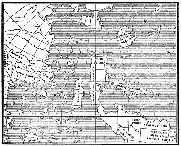
Schöner's Globe, 1520.
View larger image
This is the first drawing to represent all the regions of the New World as distinct, although not distant, from the Asiatic coast, which is laid down mostly as in Behaim's globe, with some imaginary additions round the north pole. This separation was undoubtedly a mere conjecture of the compiler, for the voyage of Magellan, which might have suggested such an idea, was not yet known or even consummated, and the map shows no knowledge of the later voyages even to the eastern coast. All the northern discoveries are given as an island, 'Terra Corterealis.' The central and southern parts—except their separation from Asia—are accurately copied from the map of Ptolemy, 1513 (see page 130), although a strait leads through the Isthmus into the South Sea. 'Terra de Cuba' is the name applied to the northern part of what may be regarded as the nucleus which afterward grew into North America, while the southern part is called Paria. Several names of localities on the coast, as 'C. Dellicontis' and 'C. Bonaventura,' are retained from the map of 1513, although Kohl erroneously calls all the names new and original. To the southern continent various names are applied, as America, Brazil, Paria (repeated), Land of Cannibals and of Parrots. On the original is an antarctic region round the south pole, called 'Brasiliæ Regio,' and separated from America in lat. 42° south by a strait, although the discovery of such a strait could not at the time have been known. Humboldt, Exam. Crit., tom. ii. p. 28. Several globes of about this date preserved in Germany are said to agree with this of Schöner's in their general features. Kohl's Hist. Discov., pp. 153-63, pl. vii., and Beiden ältesten Karten von Am., p. 33; Harrisse, Bib. Am. Vet., p. 141.
In the Solinus-Camers, Enarrationes, Vienna, 1520, was published a woodcut map, the first to give the name America. The map was made by Petrus Apianus, and afterward used by him in his cosmography. According to various descriptions it agrees very nearly with Schöner's globe except in the extreme north, where Engronelant is represented very much as in the map of the Zeni in 1400 (see page 82). Kunstmann, Entdeckung Am., pp. 134-5; Kohl, Beiden ältesten Karten von Am., p. 33; Harrisse, Bib. Am. Vet., pp. 184, 192.
Cortés with his second letter dated October 30, 1520, sent to Spain a map of the Gulf of Mexico, which was printed in 1524. The map is valuable only for its list of names along the whole extent of the gulf coast, and it is therefore unnecessary to reproduce it here. Yucatan seems to be represented as an island. Stevens' Notes, pp. 38, 53, pl. iv. no. vii.
In 1520 Lucas Vazquez de Aillon and other wealthy citizens of Española sent two vessels, probably under one Jordan, to the Lucayos Islands for slaves. Not succeeding according to their expectations in the islands, the Spaniards directed their course northward toward the country discovered by Ponce de Leon in 1513, and finally touched the coast in about 32° or 33°—Port Royal according to Navarrete; Stevens says Cape Fear—a region probably never before visited. They called the country Chicora, and the place of landing was named Cabo de Santa Elena and Rio Jordan. They made no explorations in any direction. One vessel and nearly all the slaves were lost on the return. Navarrete, Col. de Viages, tom. iii. pp. 69-71; Kohl's Hist. Discov., pp. 245-8; Stevens' Notes, p. 48.
Pánfilo de Narvaez sailed from Cuba in 1520 with a large force to dispossess Cortés, who had declared himself independent of his chief Velazquez; but after many reverses his forces went over to his opponent. Gomara, Hist. Ind., fol. 52-5; Oviedo, Hist. Gen., tom. i. p. 540; Torquemada, Monarq. Ind., tom. i. p. 474.
SOUTH SEA DISCOVERIES.
The conquest of Mexico once accomplished, Hernan Cortés very soon turned his attention to the South Sea coasts. Hearing from natives that the Pacific extended as far north as the land he had conquered, he sent small parties to explore and take possession, which they did at two points, Tehuantepec and Zacatula, before the end of 1521. Cortés was fully acquainted with the cosmographic theories of the time, and was enthusiastic in their application to the discovery of islands and main, rich in spices and precious metals. It was now established in a general way, as shown by the best maps, that the newly discovered lands were not the main Asiatic continent of Marco Polo, but a great south-eastern projection of that continent, probably separated from it by a strait. Cortés' idea was to sail down the coast as he termed it, northward at first, until he should either reach the rich Indian lands, or on the way find the strait which should afford a short cut from Spain to those lands. His efforts will be briefly noticed here in chronologic order, but fully presented in another part of my work. The best and almost only authority is Cortés, Cartas.
[1521.] Juan Ponce de Leon, learning from other voyagers that the land of Florida discovered by him was not, as he had believed it to be, an island, fitted out an expedition in Puerto Rico and sailed to repeat in Florida the glorious achievements of Cortés in New Spain. He reached the west coast of the peninsula, but was killed by the natives soon after landing, and his men returned without having accomplished their object.
Peter Martyr, De nvper svb D. Carolo repertis Insulis, Basiliæ, 1521, is the first edition of a part of the fourth decade.
[1522.] Pomponius Mela, De Orbis Sitv, Basiliæ, 1522, reproduced Apianus' map of 1520 (see page 137), also Kohl, Beiden ältesten Karten, p. 33. The Ptolemy of this year, edited by Frisius, contains two maps resembling in their general appearance the Ptolemy map of 1513, and showing but little advance in geographical knowledge. These maps are also in the edition of 1525. Asher's Catalogue, no. civ., Berlin, 1873. Translationus hispanischer, etc., n.p., n.d., has a slight notice of the City of Mexico. Ein Schöne Newe Zeytung, Augsburg (1522), notices the voyages of Columbus and the conquest of Mexico. Of the newe lãdes and of ye people founde by the Messengers of the Kynge of portygale, attributed to this year, is regarded as the first book in English to treat of America, which it calls Armenica. Cortés, Carta de Relaciõ, Seville, 1522, is the letter dated October 30, 1520, supposed to be the conqueror's second letter, the first having been lost. Eight other editions or translations appeared in various forms before 1532.
In 1522 Pascual de Andagoya followed the west coast of America southward from Panamá, to a point six or seven days' sail below the gulf of San Miguel in the province of Birú (Peru), a little beyond Point Pinos. Information obtained during this expedition concerning more southern lands, furnished the motive for the conquest of Peru undertaken a few years later by Francisco Pizarro. Pascual de Andagoya, Narrative, pp. 40-1.
Gil Gonzalez Dávila with a fleet of four vessels sailed from the islands in the Bay of Panamá, January 21, 1522, to explore the South Sea coast north-westward. Reaching the gulf of Nicoya, the limit of Espinosa's voyage, Gil Gonzalez proceeded by land and discovered Lake Nicaragua. The pilot Andres Niño continued westward, discovered and named the gulf of Fonseca, and reached, according to Herrera, dec. iii. lib. iv. cap. v.-vi., the province of Chorotega, having discovered 350 leagues of sea-coast from Nicoya, or 650 leagues from the gulf of San Miguel. Peter Martyr places Niño's ultimate limit at 300 leagues beyond the gulf of San Vicente; Ribero's map at 140 leagues west of the bay of Fonseca. Kohl, Beiden ältesten Karten von Am., pp. 163-9, thinks he probably reached the mountains south of Soconusco. See also Navarrete, Col. de Viages, tom. iii. pp. 413, 417-18; Galvano's Discov., pp. 148-9; Oviedo, Hist. Gen., tom. iii. pp. 97-114; Squier's Nicaragua, New York, 1860, pp. 157-61. Not long afterward the cities of Granada and Leon were founded, and communication with Nicaragua from the south became of frequent occurrence.
In 1522 Pedro de Alvarado occupied Tututepec on the Pacific; while at Zacatula a villa was founded, and a beginning made there on several vessels for exploration northward. Cortés, Cartas, Letter of May 15, 1522.
[1523.] Francisco de Garay fitted out a new fleet of eleven vessels, with 850 men, which sailed from Jamaica June 26, 1523. This force was intended for the conquest and settlement of Pánuco, but soon united with the army of Cortés without having accomplished anything of importance. Navarrete, Col. de Viages, tom. iii. pp. 67-9; Herrera, Hist. Gen., dec. iii. lib. v. cap. v.-vi.; Peter Martyr, dec. vii. cap. v.; Cortes, Carta tercera de Relaciõ, Seville, 1523. This third letter was written May 15, 1522. Other editions appeared in 1524, and 1532. For the bibliography of Cortés' letters see Harrisse, Bib. Am. Vet., pp. 215-23. Maximilian, De Molvccis Insulis, Coloniæ, 1523, is a letter written by the emperor's secretary, describing Magellan's voyage round the world. Other editions are mentioned as having appeared in 1523, 1524, 1534, 1536, and 1537.
[1524.] Apianus, Cosmographicus Liber, Landshutæ, 1524, contains a short chapter on America, which the author describes as an island, because he says it is surrounded by water; furthermore, he affirms this land was named from Vespucci, its discoverer. The map of Solinus-Camers, 1520, is repeated in this and in several succeeding editions of the cosmography. Kunstmann, Entdeckung Am., pp. 134-5. Francis, De Orbis Sitv ac Descriptione, Antwerp, 1524, also describes the New World.
In 1524 Cortés' fleet at Zacatula was not yet launched, the work having been delayed by fire. The conquest of Colima had however made known a good port, and brought new rumors of rich islands further north. The conqueror's plans were unchanged and his enthusiasm undiminished. His use of the term "la costa abajo," or down the coast, when he meant to sail northward, has sadly confused many writers as to his real intentions, and as to his ideas of the strait. Cortés, Cartas, Letter of Oct. 15, 1524.
In 1524 was made the first official French expedition to the New World. A fleet of four vessels was made ready under Giovanni Verrazano at Dieppe, but three of his ships were separated from him in some inexplicable manner before leaving European waters; and in the remaining one, the Dauphine, with fifty men, he sailed on the 17th of January, 1524, from an island near Madeira. After a voyage of forty-nine days, during which time he sailed 900 leagues, Verrazano struck the United States coast in about latitude 34°, perhaps at Cape Fear. Thence he sailed first southward fifty leagues, then turning about he followed the coast northward, frequently touching, to Newfoundland, whence he returned to Dieppe in July, 1524. Verrazano in his journal mentions only one date, and names but one locality; consequently there is much difference of opinion concerning his landings.
The southern limit of the voyage, so far as it can be known, was in the vicinity of Cape Romain, South Carolina, though some authors, apparently without sufficient authority—the voyager says he saw palms—have placed the limit in Florida. It is probable that a large part of the United States coast was for the first time explored during this voyage, which also completed the discovery of the whole eastern shore-line of America, except probably a short but indefinite distance in South Carolina and Georgia, between the limits reached by Ponce de Leon in 1513 and by Verrazano; one intermediate point having also been visited by Aillon in 1520. Relatione di Giouanni da Verrazzano Fiorentìno della terra per lui scoperta in nome di sua Maestà, scritta in Dieppa, adi 8, Luglio, MDXXIIII., in Ramusio, tom. iii. fol. 420. In the preface to this volume, edition of 1556, the author states that it is not known whether New France is joined to Florida or not. Herrera, Hist. Gen., dec. iii. lib. vi. cap. ix.; Hakluyt's Divers Voy., pp. 55-71; New York Hist. Soc., Collections, 1841, series ii. vol. i.; Kohl's Hist. Discov., pp. 249-70; Hakluyt's Voy., vol. iii. pp. 295-300; Aa, Naaukeurige Versameling, tom. x. app. p. 13. A chart given by Verrazano to Henry VIII. is said to have been used by Lock in compiling the map published in Hakluyt's Divers Voy., London, 1582. (Reprint by the Hakluyt Society, 1850. Copy in Kohl, p. 290.)
In 1522 Pedro de Alvarado had accomplished the conquest of Tehuantepec on the South Sea; in 1524 and the following years he extended his explorations and conquests by land across the isthmus over all the north-western region of Central America, joining his conquests to those of his countrymen from Panamá. In 1523 Cristóbal de Olid made an expedition by water to Honduras in the service of Cortés, founding a settlement; and in 1524 Cortés himself marched overland from Mexico to Honduras. Lettres de Pédro de Alvarado à Fernan Cortés, in Ternaux-Compans, Voy., série i. tom. x. pp. 107-50, and in Ramusio, Viaggi, tom. iii. fol. 296-300; Peter Martyr, dec. viii. cap. v. x.; Oviedo, Hist. Gen., tom. iii. pp. 434, 439, 475-87; Gomara, Hist. Conq. Mex., fol. 228-33, 245-6, 250-74; Herrera, Hist. Gen., dec. iii. lib. iii. cap. xvii.; lib. vi. cap. x.-xii.; lib. vii. cap. viii.-ix.; lib. viii. cap. i.-vii.; Alaman, Disertaciones, tom. i. pp. 203-25; Brasseur de Bourbourg, Hist. Nat. Civ., tom. iv. pp. 546-50, 598 et seq., 631-705.
CONQUEST OF PERU.
In this same year, 1524, Francisco Pizarro sailed from Panamá southward, and began the conquest of Peru, which, as related elsewhere in this volume, brought to light, before 1540, nearly the whole western coast of South America. For references to Pizarro's discovery see a later chapter of this volume.
A meeting of the leading pilots and cosmographers of Spain and Portugal, known as the Council of Badajoz, was convened for the purpose of settling disputed questions between the two governments. Failing in its primary purpose, the council nevertheless contributed largely to a better knowledge of New World geography. Indeed, from this time the European governments may be supposed to have had, and to have delineated on their official charts, tolerably accurate ideas of the general form of America and of its relation to Asia, except in the north-west, although the existence of a passage through the continent was still firmly believed in. Writers on cosmography and compilers of published maps did not, however, for a long time obtain the knowledge lodged in the hands of government officials.
[1525.] The man who accompanied Magellan in 1519, but left him after entering the strait and returned with one vessel to Spain, was named Estévan Gomez. In 1525 this captain was sent by Spain to search for a corresponding strait in the north. Although an official expedition, and the only one ever sent by Spain to northern parts, no journal has been preserved, and only slight particulars derived from the old chroniclers are known. Gomez expected to find a strait somewhere between Florida and Newfoundland, probably not knowing the result of Verrazano's voyage of the preceding year. Cabot was at the time piloto mayor in Spain, and if Verrazano had, as is claimed for him by some, reached the southern United States coasts, it is not likely that Gomez would have looked there so confidently for his strait. This voyage lasted about ten months, and in it Gomez is supposed to have explored the coast from Newfoundland to a point below New York—possibly to Georgia or Florida. Peter Martyr, dec. vi. cap. x.; Herrera, Hist. Gen., dec. iii. lib. viii. cap. viii.; Kohl's Hist. Discov., pp. 271-81; Navarrete, Col. de Viages, tom. iv. p. viii.; Kunstmann, Entdeckung Am., pp. 70-1. According to Harrisse, Fries, Auslegung der Mercarthen oder Cartha Marina, Strasburg, 1525, contains a map of the world, including America, but Kohl states that this map, although made in 1525, was not published till 1530. Other publications of the year are: Pietro Arias (Pedrarias Dávila), Lettere di Pietro Arias Capitano generale, della conquista del paese del Mar Occeano, written from Darien, and printed without place or date; Pigafetta, Le voyage et nauigation faict par les Espaignolz es Isles de Mollucques, an abridgment of the original account by the author, who was with Magellan; Cortes, La quarta Relacion, Toledo, 1525, dated October 15, 1524.
García de Loaisa sailed from Corunna July 24, 1525, to follow Magellan's track. Passing through the strait between January and May, 1526, he arrived at the Moluccas in October. Viages al Maluco, Segundo el del Comendador Fr. Garcia de Loaisa, in Navarrete, tom. v.; Burney's Discov. South Sea, vol. i. pp. 127-45; Relaciones del viaje hecho á las islas Molucas, in Pacheco and Cárdenas, tom. v. p. 5.
[1526.] One small vessel of Loaisa's fleet, under command of Santiago de Guevara, became separated from the rest June 1, 1526, after having reached the Pacific Ocean. Guevara decided to steer for the coast of New Spain, which was first seen in the middle of July; and on the 25th he anchored at Tehuantepec. Navarrete, Col. de Viages, tom. v. pp. 176-81, 224-5.
Cortés' exploring vessels, begun in 1522—the first having been burned on the stocks, others were built in their place—were now, after long delay, nearly ready to sail; and Guevara's vessel was brought up from Tehuantepec to join them. Cortés, Cartas, Letter of September, 1526.
Aillon, in 1523, was made adelantado of Chicora, the country discovered by him in 1520, and immediately prepared a new expedition with a view to colonize the country, explore the coasts, and to find, if possible, a passage to India. The preparations were not completed until July, 1526, when he sailed from Española with six vessels, 500 men, and ninety horses. He reached the Rio Jordan—perhaps St Helena Sound, South Carolina—and thence made a careful exploration northward, at least to Cape Fear, and probably much farther. Aillon died on the 18th of October, and after much internal dissension 150 men, all that remained alive, returned to Santo Domingo. Navarrete, Col. de Viages, tom. iii. pp. 71-4, 153-60; Kunstmann, Entdeckung Am., p. 71.
Oviedo, De la Natural hystoria de las Indias, Toledo, 1526, describes the New World, but this book is not the great historical work, lately printed, by the same author. It may be found also in Barcia, Historiadores Primitivos, and in Ramusio.
Sebastian Cabot attempted a voyage to India in 1526, sailing with four vessels in April, with the intention of bearing succor to Loaisa. Owing to insubordination among his officers, and other misfortunes, he reached only the Rio de la Plata, and after extensive explorations in that region, returned to Spain, having been absent four years. Oviedo, Hist. Gen., tom. ii. p. 169; Diccionario Universal, Mexico, apend., 'Viages,' tom. x. p. 807; Roux de Rochelle, in Bulletin de la Soc. Geog., April, 1832, p. 212.
[1527.] June 10, 1527, an English expedition—the last officially sent by that nation within the limits of my sketch—sailed from Plymouth, still in search of a north-west passage. The two vessels sailed in company to latitude 53°, and reached the coast, where, on the 1st of July, they were separated by a storm, and one of them was probably lost. The other, under John Rut, turned southward, followed the coast of New England, often landing, probably reached Chicora, and returned to England via the West India Islands, arriving early in October. Hakluyt's Divers Voy., pp. 27, 33; Biddle's Mem. Cabot, pp. 114, 275; Oviedo, Hist. Gen., tom. i. p. 611; Herrera, Hist. Gen., dec. ii. lib. v. cap. iii.
Francisco Montejo, who had accompanied the expeditions of Grijalva and Cortés, and had since been sent by the latter as ambassador to Spain, obtained from the king in 1526 a commission as adelantado to conquer the "islands of Yucatan and Cozumel." He sailed from Seville in 1527, landed at Cozumel, penetrated the northern part of the peninsula, and during the following years fought desperately to accomplish its conquest, but failed. A small colony struggled for existence at Campeche for several years, but in 1535 not a single Spaniard remained in Yucatan. Cogolludo, Hist. Yucathan, pp. 59-94; Gomara, Hist. Ind., fol. 62-3; Stephens' Incidents of Travel in Yucatan, New York, 1858, vol. i. pp. 56-62.
La Salle, La Salade, Paris, 1527, contains references to Greenland and other northern parts of America.
PACIFIC COAST EXPLORATIONS.
In July, 1527, three of the vessels built by Cortés made a preliminary trip up the Pacific coast from Zacatula to Santiago in Colima and back—the first voyage along that coast. Relacion ó Derrotero, in Pacheco and Cárdenas, Col. Doc., tom. xiv. pp. 65-9; Relacion de la Derrota, in Florida, Col. Doc., pp. 88-91. But an order from Spain required the fleet to be sent to India direct—instead of by the roundabout route proposed by Cortés—for the relief of Loaisa; and the three vessels sailed from Zacatula in October under Saavedra, arriving safely in India. Guevara's ship was too worm-eaten to accompany them; but several vessels were already on the stocks at Tehuantepec to replace those sent across the ocean. Sutil y Mexicana, Viage, introd. pp. vi.-xi.; Navarrete, Col. Viages, tom. v. pp. 95-114, 181, 440-86; Gil, Memoria, in Boletin de la Soc. Mex. Geog., tom. viii. p. 477 et seq.
In 1527 Robert Thorne, English ambassador to Charles V., wrote a book or memorial to Henry VIII. on cosmography, on the Spanish and Portuguese discoveries, and on the importance of exploring northward for a passage to Cathay. It was afterward printed as The booke made by the right worshipful M. Robert Thorne, in Hakluyt's Voy., vol. i. pp. 214-20.
In 1526 a commissioner was appointed to correct the Spanish charts. Fernando Colon was charged with the revision, and in 1527 a map was made called Carta universal en que se contiene todo lo que del mundo se ha descubierto fasta agora. This map has been preserved, and a fac-simile is given in Kohl, Beiden ältesten Karten von Am. It shows the whole eastern coast line from the strait of Magellan to Greenland, and the western coast from Panamá to the vicinity of Soconusco, and indicates that the information in possession of the Spanish government was remarkably accurate and complete. Yucatan is represented as an island, and the discoveries on the Pacific side of South America are not laid down; otherwise this map varies but little except in names from a map made by Diego Ribero, in 1529, of which I shall give a copy. Kohl, Beiden ältesten Karten von Am., pp. 1-24; Humboldt, Exam. Crit., tom. ii. p. 184, and Preface to Ghillany.
[1528.] Bordone, Libro di Benedetto Bordone Nel qual si ragiona de tutte l'Isole del mondo, Vinegia, 1528, gives maps of the larger American islands, and also a map of the world, the American part of which I copy from the original. No part of the western coast is shown, although the New World is represented as distinct from Asia.
Kohl, Beiden ältesten Karten von Am., p. 34, mentions another work printed at Venice the same year, which has a map resembling that of Schöner in 1520.
Pánfilo de Narvaez sailed from Spain in 1527 with five ships and 600 men, to conquer the northern shores of the Gulf of Mexico, and after losing some of his ships by storm, and many of his men by desertion, in cruising about Española, Cuba, and other islands, he landed in the vicinity of Tampa Bay April 14, 1528, and nearly all the company perished in an attempt to follow the coast toward Vera Cruz. Cabeça de Vaca's Relation, New York, 1871, pp. 13-20; Herrera, Hist. Gen., dec. iv. lib. iv. cap. iv.-vii.; lib. v. cap. v.
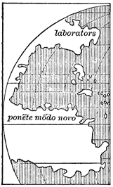
Map by Benedetto Bordone, 1528.
View larger image
[1529.] Major, Prince Henry, pp. 440-52, entertains the opinion that Australia was discovered probably before 1529, and certainly before 1542.
In 1529 was made the before-mentioned Spanish official map by Diego Ribero, which may be supposed to show all that was known by European pilots at that time of New World geography. It contains some improvements and additions to Colon's map of 1527 with the same title, although criticised, perhaps justly, by Stevens as partisan in its distribution of the new regions among the European powers. I give a copy reduced from the full-sized fac-simile in Kohl, Beiden ältesten Karten von Am.
Greenland is called Labrador and is joined to the continent, as the separating strait had not at the time been explored. It will be noticed that Greenland is far less accurately laid down on this and other late maps than on some earlier ones which are supposed to have derived some of their details from northern sources. Labrador, Newfoundland, and Nova Scotia have the general name of Bacallaos. Many of the numerous islands along the coast are named in the original. Corresponding perhaps to the New England and middle United States we have the 'Tiera de Estevã Gomez,' stated by an inscription to have been discovered by the Spaniards in 1525. From this land to Florida extends the 'Tiera de Ayllon,' between which and 'Nveva España' comes the 'Tiera de Garay,' thus dividing nearly all of the northern continent among the Spaniards. The West India Islands have here their true number, position, and names. Yucatan is given in its true proportions but is separated by a strait from the main-land. The South Sea coast is represented only to the limit of the voyage of Gil Gonzalez Dávila on the north, and extends southward to the port of Chinchax in about latitude 10° south, including, according to an inscription, the countries which had been reached by Pizarro in 1527. The form of South America is correctly laid down and the name 'Mvndvs Novvs' is applied to the whole, which is divided into the provinces of 'Castilla del Oro,' 'Perv,' 'Tiera del Brasil,' 'Tiera de Patagones,' and 'Tiera de Fernã de Magallaes,' or land of Magellan. South of the strait is the 'Tiera de los Fuegos,' whose true form and extent were not known until Schouten and Le Maire doubled Cape Horn in 1616.
Thus far I have copied or mentioned all maps which could throw any light on the progress of geographical knowledge, and have endeavored to give a statement of all the voyages by which this progress was made. Thus far we have seen the coasts of both North and South America, except in the south-west and the far north-west, more or less carefully explored by European voyagers; we have seen the New World recognized as distinct for the most part from Asia, a tolerably correct idea of its form and extent given by government pilots, and the name America applied, except on official maps, to the southern continent. Henceforth voyages to the parts already discovered become of common occurrence, and numerous maps, both in manuscript and print, are made, no one of which I shall attempt to follow. In the expeditions of the next and concluding ten years of this Summary I shall notice chiefly those by which a knowledge was acquired of the countries lying toward California and the great Northwest, presenting several maps to illustrate this part of the subject.
[1530.] During the absence of Cortés in Spain no progress had been made in maritime exploration; and by 1530 his ships on the stocks at Tehuantepec were ruined, but he made haste to build more. Cortés, Cartas, letters of Oct. 10, 1530, and April 20, 1532.
NUÑO DE GUZMAN.
Nuño de Guzman, formerly president of the audiencia of New Spain, and the inveterate enemy of Cortés, undertook with a large force, recruited in Mexico, the conquest of the region lying to the north-west of that city. The northern limit of his conquest in 1530-1 was Culiacan, between which and Mexico the whole country was brought under Spanish control by expeditions sent by Guzman in all directions under different leaders. Relation di Nvnno di Gvsman, in Ramusio, tom. iii. fol. 331, and abridged in Purchas, His Pilgrimes, vol. iv. p. 1556; Jornada que hizo Nuño de Guzman á la Nueva Galicia, in Icazbalceta, Col. de Doc., tom. ii.; Primera relacion, p. 288; Tercera relacion, p. 439; Cuarta relacion, p. 461; Doc. para Hist. de Mex., serie iii. p. 669; Mota Padilla, Conquista de Nueva Galicia, MS. of 1742; Oviedo, Hist. Gen., tom. iii. pp. 559-77; Gil, Memoria, in Boletin de la Soc. Mex. Geog., tom. viii. p. 424 et seq.
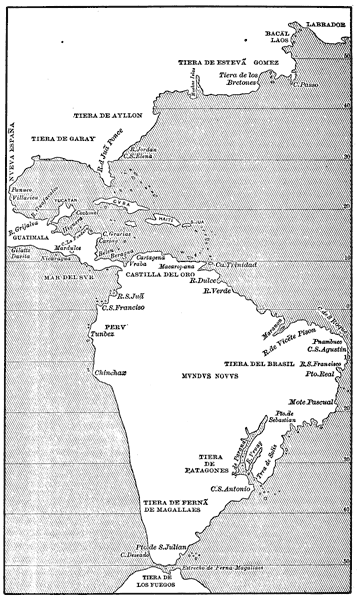
Diego Ribero's Map, 1529.
View larger image
Hakluyt, in his Voyages, vol. iii. p. 700, states that one William Hawkins, of Plymouth, made voyages, in a ship fitted out at his own expense, to the coast of Brazil in 1530 and 1532, bringing back an Indian king as a curiosity.
PETER MARTYR, PTOLEMY, AND MUNSTER.
Peter Martyr, De Orbe novo, Cõpluti, 1530, is the first complete edition of eight decades; and Opus Epistolarum, of the same date and place, is a collection of over eight hundred letters written between 1488 and 1525, many of them relating more or less to American affairs.
In the Ptolemy of 1530, in several subsequent editions, and in Munster's Cosmography of 1572 et seq., is the map of which the following is a reduction.
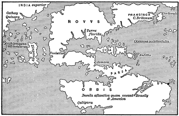
The New World, from Ptolemy, 1530.
View larger image
I give this drawing, circulated for many years in standard works, to illustrate how extremely slow were cosmographers to form anything like a correct idea of American geography, and how little they availed themselves of the more correct knowledge shown on official charts. The following map, made in 1544, illustrates still further the absurdities circulated for many years under the name of geography. Scores of additional examples might be given.
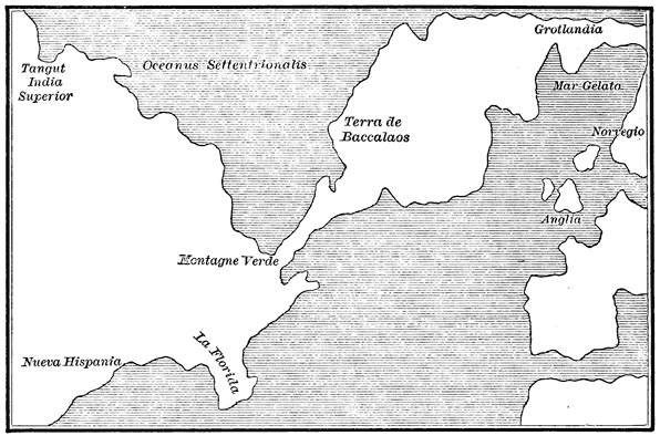
Ruscelli's Map, 1544.
View larger image
[1532.] At last, in the middle of 1532, Cortés was able to despatch from Acapulco two vessels, under Hurtado de Mendoza and Mazuela, to make the first voyage up the coast beyond Colima. Mendoza touched at Santiago and at the port of Jalisco, near the later San Blas, discovering the islands of Magdalena, or Tres Marías. Then they took refuge from a storm in a port located only by conjecture, probably on the Sonora coast, where after a time the vessels parted. Mendoza went on up the coast. Having landed and ascended the Rio Tamotchala—now the Fuerte—he was killed, with most of his men, by the Indians. The rest were massacred a little later, when the vessel grounded and broke up at the mouth of the Rio Petatlan, or Sinaloa. Meanwhile, Mazuela with the other vessel returning down the coast was driven ashore in Banderas Bay, where all his men but two or three were killed by the natives. Authorities, being voluminous, complicated, and of necessity fully presented elsewhere, are omitted here.
Cortes, De Insvlis nvper inventis, Coloniæ, 1532, is a translation of Hernan Cortés' second and third letters, with Peter Martyr's De Insulis, and a letter from Fray Martin de Valencia, dated Yucatan, June 12, 1531, with some letters from Zumárraga, first bishop of Mexico.
Grynævs, Novvs Orbis, Paris and Basle, 1532, is a collection of the voyages of Columbus, Pinzon, Vespucci, and others. In this work the assertion is made that Vespucci discovered America before Columbus, which aroused the wrath of Las Casas, and seems to have originated the subsequent bitter attacks on Vespucci. About the maps originally published with this work there seems to be some doubt, most copies, like my own, having no map. According to Stevens' Notes, pp. 19, 51-2, pl. iii. no. 4, the Paris edition of Grynæus contained a map made by Orontius Fine in 1531. The following is a reduction from Stevens' fac-simile on Mercator's projection: