VOLUME XIV SLICE VI Inscriptions to Ireland, William Henry (continued 12)
Reading edition
Climate.—The climate is one of great extremes of heat and cold, with a dry winter and a usually wet summer, the prevailing wind of winter being N.W. while in summer it not infrequently blows from the S.W. Both the midwinter isotherm of Montreal and the mid-summer one of Washington, D.C., pass through the state. The mean annual temperature is 47.5° F.; the average range of extremes per year during the decade ending with 1900 was 136° F., while the greatest extremes recorded are from −43° F. in 1888 to 113° F. in 1901, a difference of 156° F. From 1893 to 1898 the average mean annual temperature at Cresco in Howard county, near the N.E. corner of the state, was 44.3° F., while at Keokuk in the S.E. corner it was 52.2° F., and as the isotherms cross the state, especially in the N., their tendency is to move S.W. The rainfall is also very unequal in distribution throughout the year, as also between the same periods of different years, and as between the different parts of the state. For while the mean annual precipitation is 31.42 in., 22.48 in., or 71% of this, fall during the six months from the 1st of April to the 1st of October, or 10% in winter, 23% in autumn, 28% in spring and 39% in summer, June and July being the two wettest months. At the same time extremes during the four most critical crop months, from the 1st of May to the 1st of September, have ranged from 6.75 in. in 1894 to 27.8 in. in 1902. Within any one year the precipitation is in general usually less in the western part of the state than in the eastern, the mean difference for all the years of record up to the close of 1903 being 2.5 in.; the western part also is marked by having a still larger per cent of its rain in spring and summer than has the eastern. The unequal distribution throughout the state is in much larger measure due to local showers. Injury to crops from drought and hot winds has occurred about two or three times in a decade, but liability to injury of the crops from excessive rainfall and hailstorms is greater than that from a deficiency of moisture. Three notable tornadoes have swept portions of the state: the Comanche in June 1860, the Grinnell in June 1882 and the Pomeroy in July 1893; but the greatest area traversed by any of these was less than one-twentieth of 1% of the total area of the state, and this kind of storm has been less destructive to human life, animals and buildings than the lightning which accompanies summer showers.
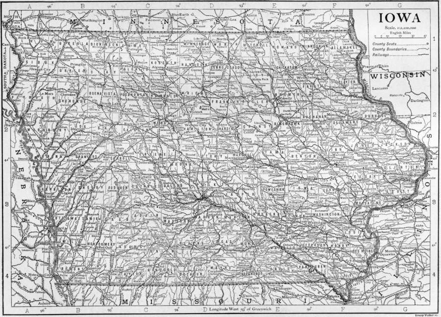
(Click to enlarge.)
Soil, Agriculture.—Its depth, together with its porous nature, makes the fertile soil of Iowa capable of withstanding the extremes of wet and dry remarkably well, and it is perhaps true that, taken as a whole, no other state in the Union has a superior soil for agriculture. Certainly no other has so many acres of improved land, or so large a proportion—from 85 to 90%—of its land subject to cultivation. The soil is of four kinds: till or drift, alluvial, loess or bluff and geest. The dark drift, composed chiefly of clay, sand, gravel, boulders and lime, is both the soil and subsoil of the greater part (about 66%) of the state, being especially predominant in the N. and N.W. The alluvial soil, composed of what has been washed from other soils, together with decayed vegetable matter, covers about 6% of the surface of the state and is found in the river bottoms, of greatest extent in that of the Missouri; it varies much in fertility. The loess soil, chiefly a mixture of porous clay and carbonate of lime, forms the bluffs bordering the bottom lands of the Missouri and is common in the N.E. Its fertility is not inferior to that of the better drift. Geest is found particularly in the north-eastern part of the state; it covers less than 1% of the area of the state.
The superior qualities of the soil, together with the usually warm and moist months of spring and summer, make Iowa one of the foremost states of the Union in agriculture and stock-raising, especially in the production of Indian corn, oats, hay and eggs, and in the raising of hogs, horses, dairy cows and poultry. In comparison with its other industries it stands also pre-eminently as an agricultural state; for of its 789,404 labourers in 1900, 371,604, or 47%, were engaged in agriculture, 129,006 being engaged in trade and transportation, and 124,803 in manufactures and mechanical pursuits. In 1899 the total value of the agricultural products, $365,411,528, was greater than that of any other state. Of the farms 65.1% were cultivated by owners in 1900, a decrease from 76.2% in 1880; and 19.5% were cultivated by cash tenants, an increase from 4.5% in 1880. After 1880 the percentage of farms operated by share tenants slowly but steadily decreased, falling from 19.4% in 1880 to 15.4% in 1900. Between 1880 and 1900 the average number of acres to a farm slightly increased—from 133.5 acres in 1880 to 151.2 acres in 1900—instead of decreasing as in the older states of the Union; though the increase was not nearly so marked as in such states as Nevada, Montana, Wyoming and Texas. Iowa about equals Illinois in the production of both Indian corn and oats, nearly 10,000,000 acres or about one-third of its improved area usually being planted with Indian corn, with a yield varying from 227,908,850 bushels in 1901 (according to state reports) to 373,275,000 (the largest in the United States, with a crop value second only to that of Illinois) in 1906. According to the Department of Agriculture in 1907 the acreage was 9,160,000 and the yield 270,220,000 bushels (considerably less than the Illinois crop); the yield of oats was 168,364,170 bushels (Twelfth U.S. Census) in 1899, 124,738,337 bushels (U.S. Department of Agriculture) in 1902, and in 1907 the acreage and crop (greater than those of any other state) were 4,500,000 acres and 108,900,000 bushels, valued at $41,382,000—a valuation second only to that of Illinois. In total acreage of cereals (16,920,095 in 1899) it ranked first (Twelfth Census of the United States), and in product of cereals was exceeded by Illinois only; in acreage of hay and forage (4,649,378 in 1899) as well as in the annual supply of milk (535,872,240 gallons in 1899) it was exceeded by New York only. In 1905, according to railway reports, 91,051,551 ℔ of butter were carried to points outside the state. It ranked far ahead of any other state in 1908 in the number of its hogs (8,413,000, being 15% of the whole number in the United States), Illinois, the second in rank, having only about half as many. It ranked first in 1900 in the number of horses (1,392,573); in the number of poultry (about 20,000,000); in the annual egg product (99,621,290 dozen in 1899); in the total acreage of all crops (22,170,000); in the total value of agricultural products; and in the total value of live stock ($271,844,034). In 1899 it ranked fourth in the production of barley (18,059,050 bushels) and in 1907 sixth (14,178,000 bushels). The wheat crop has varied from 12,531,304 bushels in 1903, 13,683,003 bushels in 1905, 7,653,000 bushels in 1907 (according to the U.S. Department of Agriculture), to 22,769,440 bushels (Twelfth Census) in 1899. Potatoes, apples and small fruits are grown successfully. For the most part the several crops are quite evenly distributed throughout the state; but nearly all the winter wheat is grown in the S. and N.W., spring wheat most largely in the N.W., barley mostly in the N., flax-seed and prairie hay in the N.E.
Minerals.—The first mines to be worked in Iowa were those for lead and zinc at Dubuque and to the northward. These are little mined at present, only 110 tons of lead ore and 516 tons of zinc ore being taken from the mines in 1908. Of more promise is the gypsum deposit extending over an area of about 50 sq. m. in the vicinity of Fort Dodge (Webster county), from which was taken in 1908 a product valued at $565,645, having increased to that figure from $45,819 in 1898. Limestones and sandstone are also profitably quarried, the value of the product in 1908 being $530,945 for limestone and $2337 for sandstone. The principal mineral of Iowa, however, is bituminous coal; it ranked in 1908 eighth among the coal-producing states of the Union, its product being valued at $11,706,402. The beds lie in the southern half of the state, extending under about two-fifths of its surface.
Trade and Commerce.—The manufactures of Iowa are chiefly such as have to do with the products of the farm. Meat packing is the most important, the product of this industry amounting in 1900 to $25,695,044, and in 1905 to $30,074,070, an increase of 17% in this period; in 1900 the state was seventh, in 1905 sixth, among the states in the value of this industry, producing in each year 3.3% of the total. Next in importance is the manufacture of dairy products, the value of which in 1900 was $15,846,077 (an increase of 50.3% in ten years) and in 1905 was $15,028,326; at both censuses the state ranked third in the value of cheese, butter, and condensed milk and of food preparations, which were valued at $6,934,724 in 1905. Flour and grist-mill products ranked third both in 1900 and 1905, the value of the product for the later year being $12,099,493, an increase of 9.9% over the value for the earlier. Among the lesser manufactures are lumber and timber products (value in 1905, $5,610,772), most of the raw material being floated down on rafts from Wisconsin and Minnesota. The largest centres of industry are Sioux City, Davenport, Dubuque, Des Moines, Burlington and Council Bluffs. In 1905 the gross value of the manufactured product (of establishments on the factory system) was $160,572,313, as against $132,870,865 in 1900, an increase of 20.8%; whereas, even including the products of smaller establishments not technically factories, the value of the product in 1850 was only $3,551,783, and in 1880 was only $71,045,926.
The means of transportation is afforded chiefly by the steam railways, of which the state had 9,907.44 m. in January 1909. Scarcely a farm is more than 6 or 8 m. from a railway station; and only three other states have a greater railway mileage. The great period of railway building in Iowa was during the twenty-five years immediately following the close of the Civil War, the railway mileage being only 655 m. in 1860. The several roads are under the management of twenty-seven companies, but about 75% of the business is done by the Chicago Burlington & Quincy, the Chicago & North-Western, the Chicago Milwaukee & St Paul and the Chicago Rock Island & Pacific. Electric interurban railways are increasing in importance for freight and passenger service. In 1908 about 225 m. of such railways were in operation. Transportation facilities by water are afforded by the Mississippi river. The former difficulties with the Des Moines Rapids of the Mississippi (which are passable for rafts and light boats at high water) have been overcome by a canal from Keokuk to Montrose constructed by the National Government. Other federal improvements undertaken are a harbour at Muscatine, a harbour of refuge below Davenport and channel improvements at Clinton.
Population.—The population of Iowa in 1850 was 192,214; in 1860, 674,913; in 1880, 1,624,615; in 1890, 1,911,896; in 1900, 2,231,853. The state census of 1905 showed a total population of 2,210,050, and the Federal census of 1910, of 2,224,771. Of the population in 1905, 1,264,443 (57.2%) were native whites of native parentage, 648,532 (29.3%) were native whites of foreign parentage, 289,296 (12.8%) were foreign-born and 14,832 (0.7%) were coloured, including 346 Indians. The Indians, a remnant of the Sauk and Foxes, are most unprogressive, and are settled on a reservation in Tama county in the east-central section of the state.
In 1906 it was estimated that there were 788,667 communicants of all religious denominations; of these 207,607 were Roman Catholics; 164,329 Methodists; 117,668 Lutherans; 60,081 Presbyterians; 55,948 Disciples of Christ; 44,096 Baptists; 37,061 Congregationalists; 11,681 members of the German Evangelical Synod; and 8990 Protestant Episcopalians.
The rural element of the population is large, though it is not increasing as rapidly as the urban; and no other state in the Union is so uniformly settled. There were in 1905 seven cities with a population of 25,000 or more; twenty with 8000 or more; and thirty-seven with 4000 or more. Between 1890 and 1900 the urban population increased 38.3%, while the rural increased 14.6%. The chief cities are Des Moines (pop. in 1905, 75,626), Dubuque (41,941), Davenport (39,797), Sioux City (40,952), Cedar Rapids (28,759), Council Bluffs (25,231) and Burlington (25,318).
Government.—There is comparatively little in the political institutions of Iowa dissimilar to those of other states of the Union; they show in recent years a tendency toward greater centralization—in boards, however, rather than in individual officers. The constitution now in force was adopted in 1857, the constitution of 1846 having been superseded chiefly on account of its prohibition of banking corporations. The present one admits of amendment by a vote of a majority of the members of both houses of the legislature, followed by a majority vote of the electors in the state voting on the amendment; and by this process it was amended in 1868, 1880, 1884 and 1904. The present constitution also provides that the question, “Shall there be a convention to revise the constitution and amend the same?” shall be submitted to the people once every ten years (beginning with 1870), but the affirmative vote taken in accordance with this provision has hitherto been small. The suffrage now belongs to all male citizens of the United States at least twenty-one years of age who shall have resided in the state for six months, and in some one county sixty days preceding an election, except idiots and persons insane or convicted of some infamous crime. The franchise was conferred on negroes by an amendment adopted in 1868. Prior to 1904 elections were annual, but by an amendment of that year they became biennial.
The central executive and administrative authority is vested in a governor, a lieutenant-governor, an executive council, several boards and a few other officers. The governor and the lieutenant-governor was elected for a term of two years, and the qualifications for both offices require that the incumbents shall be at least thirty years of age and shall have been for two years immediately before their election residents of the state. Under the Territorial government when first organized the governor was given an extensive appointing power, as well as the right of an absolute veto on all legislation, but this speedily resulted in such friction between him and the legislature that Congress was petitioned for his removal, with the outcome that the office has since been much restricted in its appointing power, and the veto has been subjected to the ordinary United States limit, i.e. it may be overridden by a two-thirds vote of both houses of the legislature. Members of boards of regents or trustees of state institutions are for the most part elected by the General Assembly; railway commissioners are elected by the state electors; while in the case of the few appointments left for the governor, the recommendation or approval of the executive council, a branch of the legislature, or of some board, is usually required. He, however, is himself a member of the executive council as well as of some important boards or commissions, and it is in such capacity that he often has the greatest opportunity to exert power and influence. His salary is $5000 per annum (with $600 for house rent and $800 as a member of the executive council). The executive council, composed of the governor, secretary of state, auditor of state and treasurer of state, all elected by the people for a term of two years, has extensive powers. It supervises and audits the accounts of state departments, directs the taking of the census, transfers cities from one class to another in accordance with census returns, constitutes the board for canvassing election returns, classifies railways, assesses railway and other companies, constitutes the state board of equalization for adjusting property valuations between the several counties for taxing purposes, supervises the incorporation of building and loan associations, appoints the board of examiners of mine inspectors and has many other powers. Among other state boards the more important are the board of railroad commissioners, the board of control of state institutions, the board of health, and the board of educational examiners.
The state legislature, or General Assembly, composed of a senate and a house of representatives, sits biennially at Des Moines. Senators are elected for a term of four years, one from each of fifty senatorial districts, the term of one-half expiring every two years. Senators must be at least twenty-five years of age and residents of the state for one year at the time of election. Representatives are elected for a term of two years, one from each of the ninety-nine counties, with an additional one from each of the counties (not exceeding nine) having the largest population; the ratio of representation and the apportionment of the additional representatives from the larger counties is fixed by the General Assembly. The qualifications for representatives differ from those for electors only in that they must have been residents of the state for one year at the time of election, the disqualification of negroes for sitting in both senate and house having been removed by an amendment adopted in 1880. No bill can pass either house without the assent of a majority of all the members elected to that house; the governor is allowed three days (Sunday excepted) in which to veto a bill.
The state judiciary consists of a supreme court of six judges and a district court of fifty-three judges, from one to four in each of twenty districts. The supreme court has three sessions a year, while each district-court judge is directed to hold at least one session a year in each county of his district, and no two district-court judges may sit together on the same case. The supreme court has appellate jurisdiction in chancery cases only, but may correct errors at law in other cases. The district court has general, original and exclusive jurisdiction in all matters civil, criminal and probate not expressly conferred on an inferior court, and may hear appeals from inferior courts, boards or officers.
For purposes of administration and local government the state is divided into ninety-nine counties, each of which is itself divided into townships that are usually 6 m. square. The township may be divided into school districts and highway districts, but in these matters option has resulted in irregularity. Each county has its own administrative boards and officers; and there are two justices of the peace and two constables for every township. The board of supervisors, consisting of not more than seven members, elected for a term of three years, has the care of county property and the management of county business, including highways and bridges; it fixes the rate of county taxes within prescribed limits, and levies the taxes for state and county purposes. The officers of the township are three trustees, a clerk and an assessor. The trustees are elected for a term of three years, the clerk and assessor for two years. All taxable property of the state, that of corporations for the most part excepted, is assessed by the township assessor.
The municipal corporations are civil divisions quite independent of the county and township system. They are divided into cities of the first class, cities of the second class and towns, besides a few cities with special charters. Cities of the first class are those having a population of 15,000 or over; cities of the second class are those having a population of 2000 but less than 15,000; all other municipal corporations, except cities with special charters, are known as incorporated towns. In all these cities and towns a mayor, council and various officers are elected, and also a police judge in cities of the first class where there is no superior court. By a law of 1907 cities with a population of 25,000 or more may adopt a commission form of government, with a mayor and four councilmen elected at large on a non-partisan ticket.
Under the laws of Iowa a wife enjoys property rights equal to those of her husband. The expenses of the family, including the education of the children, are chargeable alike upon the property of either or both. Otherwise, the wife may control her property as if single, and neither is liable for what are clearly the debts of the other. In case of the death of either, one-third of the property of the deceased becomes that of the survivor. A homestead cannot be conveyed or encumbered without the consent of both husband and wife, if held by a married man; and a homestead, to the value of $500, is exempt from liability for debts postdating the purchase, unless for improvements on the property. A petition for a divorce may be presented after a residence within the state of one year immediately preceding, and a decree may be granted against the defendant if judged guilty of adultery, desertion for two years without reasonable cause, habitual drunkenness, such inhuman treatment as to endanger the life of the plaintiff, or if convicted of felony after marriage. In 1882 an amendment to the constitution was passed prohibiting the manufacture and the sale of intoxicating liquors within the state. In April 1883 the Supreme Court pronounced this amendment invalid on the ground of irregularity in recording it, whereupon the legislature provided for a like prohibition in an ordinary statute. But attempts to execute this were so unsuccessful that it has been succeeded by a law imposing what is known as the “mulct tax,” which requires the payment of $600 in quarterly instalments for a licence to sell such liquors and places a lien for the whole amount on the real property in use for the business. One-half the proceeds goes to the county and one-half to the municipality or township in which the liquor is sold. The exceptional dependence of Iowa on eastern markets has given more than ordinary prominence to railway legislation, and the conflict of interests between the railways and the shippers has agitated the state for forty years, various attempts being made to regulate freight rates by legal enactment. In 1888 an elective commission was established with power to fix maximum rates, which has met with general commendation throughout the country.
The charitable, penal and reformatory institutions of the state are all under a “Board of Control of State Institutions,” composed of three electors appointed by the governor and approved by two-thirds of the senators, careful provision being made also to prevent the board from becoming subject to either political party. The institutions under its charge include a Soldiers’ Orphans’ Home at Davenport; a Soldiers’ Home at Marshalltown; a College for the Blind at Vinton; a School for the Deaf at Council Bluffs; an Institution for Feeble-minded Children at Glenwood; an Industrial School for Boys at Eldora; an Industrial School for Girls at Mitchellville; and, at Oakdale, a Sanatorium for the Treatment of Tuberculosis. The Board of Control of State Institutions has supervisory and inquisitorial powers over all county and private institutions in the state in which insane are kept, and over homes for friendless children maintained by societies or institutions. In 1907 the General Assembly passed a law under which the indeterminate sentence was established in the state, and the governor appoints a Board of Parole of three members, of whom one must be an attorney and not more than two are to belong to the same political party.
Education.—The percentage of illiterates (i.e. both those unable to read and write and those unable to write) ten years of age and over, according to the census returns of 1900, was only 2.3; of all the other states of the Union, Nebraska alone made such a good return. But teachers were poorly paid, and fourteen schools have been closed at a time within a single county from want of teachers. However, there are laws requiring that each school be taught at least six months in a year, and that children between the ages of seven and fourteen attend for at least twelve consecutive weeks, and for a total of sixteen weeks in every year. In 1905-1906 male teachers received on an average $63.97 per month, women teachers, $43.41. Although the electors of each school district have ample powers reserved to them, in actual practice matters are attended to chiefly by an elected board of directors. The county administration is in the hands of a board of education and a superintendent. The school tax was derived in 1905-1906 from interest on the state’s permanent school fund—amounting to 2.3% of the total tax, and distributed in proportion to the population of school age; from a 1 to 3 mill county tax, amounting to 5.2% of the whole; and from local or district taxation, 92.5% of the entire tax. A law of the state provides for the establishment of a county high school whenever a majority of the electors of a county desire it, but in 1902 only one county (Guthrie county) had such a school. The number of public high schools in towns and cities, however, increased from 256 in 1893 to 345 in 1903. The state established a university at Iowa City in 1847, a State Agricultural College and Model Farm in 1858 (opened at Ames in 1869 as the Iowa State College of Agriculture and the Mechanic Arts), an Agricultural Experiment Station in 1887, an Engineering Experiment Station in 1904, and a normal school at Cedar Falls in 1876.
At the head of the whole system is the state superintendent of public instruction, assisted by a board of educational examiners. In 1901 the total receipts for school purposes were $6,001,187; and the total disbursements $5,813,541; in 1906 the receipts were $7,126,162.12 and the disbursements $6,950,580.27. The pupils enumerated in 1906 were 707,843. Educational institutions not supported by the state include: Iowa Wesleyan University (Methodist, opened in 1842) at Mt. Pleasant; Iowa College (Congregational, 1848) at Grinnell; Central University of Iowa (Baptist, 1853) at Pella; Cornell College (Methodist, 1857) at Mt. Vernon; Western College (United Brethren, 1856) at Toledo; Upper Iowa University (Methodist Episcopal, 1857) at Fayette; Leander Clark College (United Brethren, 1857) at Toledo; Lenox College (Presbyterian, 1859) at Hopkinton; Luther College (Norwegian Evangelical Lutheran, 1861) at Decorah; Des Moines College (Baptist, 1865) at Des Moines; Tabor College (Congregational, 1866) at Tabor; Simpson College (Methodist, 1867) at Indianola; Wartburg Kollege (Lutheran, 1868) at Clinton; Amity College (Non-sectarian, 1872) at College Springs; German College (Methodist Episcopal, 1873) at Mt. Pleasant; Penn College (Friends, 1873) at Oskaloosa; St Joseph’s College (Roman Catholic, 1873) at Dubuque; Parsons College (Presbyterian, 1875) at Fairfield; Coe College (Presbyterian, 1881) at Cedar Rapids; Drake University (Disciples of Christ, 1881) at Des Moines; Palmer College (Disciples of Christ, 1889) at Legrand; Buena Vista College (Presbyterian, 1891) at Storm Lake; Charles City College (Methodist Episcopal, 1891) at Charles City; Morningside College (Methodist Episcopal, 1894) at Sioux City; Graceland College (Reorganized Church of Latter Day Saints, 1895) at Lamoni.
Finance.—The taxing system of Iowa embraces a general property tax, corporation taxes (imposed on the franchises or on either the capital stock or the stock in the hands of shareholders), taxes on certain businesses and a collateral inheritance tax. Several important attempts have been made to effect a segregation as between state and local taxes, but for the most part without success. For the year ending June 30th, 1908, the receipts of the state from all sources were $3,663,154.67, and the total expenditure was $3,891,842.81. The full value of all property, according to assessment of 1904, is $2,567,330,328. The state has no bonded debt, and the constitution forbids it to incur debts exceeding in the aggregate a quarter of a million dollars, except for warlike purposes or for some single work to which the people give their consent by vote; the constitution also forbids any county or municipal corporation from incurring an indebtedness exceeding 5% of the value of its taxable property. When first admitted into the Union, Iowa had a strongly pronounced antipathy to banks. This was largely overcome by the year 1857, and yet the constitution of that date prohibits any legislation of primary importance relating to banks without referring the matter to a direct vote of the people. The number of banks and the amount of banking business has, nevertheless, rapidly increased.
History.—Iowa, as a part of the whole Mississippi Valley, was taken into the formal possession of France in 1682; in 1762 as a part of the western half of that valley it was ceded to Spain; in 1800 it was retroceded to France; in 1803 was ceded to the United States; from 1804 to 1805, as a part of the District of Louisiana, it was under the government of Indiana Territory; from 1805 to 1812 it was a part of Louisiana Territory; from 1812 to 1821 a part of Missouri Territory; from 1821 to 1834 a part of the unorganized territory of the United States; from 1834 to 1836 a part of Michigan Territory; from 1836 to 1838 a part of Wisconsin Territory. In 1838 Wisconsin Territory was divided, the western portion being named Iowa, and out of this the state with its present bounds was carved in 1846.
The name Iowa (meaning “sleepy ones”) was taken from a tribe of Siouan Indians (probably of Winnebago stock), which for some time had dwelt in that part of the country and were still there when the first white men came—the Frenchmen, Marquette and Joliet, in 1673 and Hennepin in 1680. Early in the next century the Sauk and Foxes, vanquished by the French in Michigan, retreated westward, and in their turn largely supplanted the Iowas. Thither also came Julien Dubuque, a French Canadian, to trade with the new occupants. He discovered lead mines on and near the site of the city which now bears his name, in 1788 obtained an Indian grant or lease of about 21 sq. m., established there a settlement of miners and continued his mining operations, together with a trade in furs, until his death in 1810. The Indians refused permission to others to work the mines, and when intruders attempted to do so without it United States troops protected the red man’s rights, especially from 1830 to 1832. But Black Hawk’s war policy soon resulted in letting the white man in; for the war which he instigated was concluded in 1832 by a cession to the United States of nearly 9000 sq. m., embracing much of what is now the district of the Iowa lead and zinc mines. Without further waiting, though still in the face of the Act of Congress of 1807 prohibiting such settlements, the frontiersmen rushed in to mine and to farm, and government was established through voluntary associations. Such proceedings of these associations as related to claims to land were later recognized by the United States authorities, while such as related to the establishment of schools were tolerated for a time by the state government. Iowa, having separated from Wisconsin in 1838 on account of lack of courts for judicial relief, the question of applying for admission into the Union as a state was voted on as early as 1840, the Territory in that year having a population of 43,112; but the measure was defeated then, as it was again in 1842, by those who most wished to avoid an increase of taxes. In 1844, however, the vote was otherwise, a convention was called, a constitution framed and application for admission made. The question of boundaries, to which the question of slavery gave rise, then became the cause of delay, but the Territory became a state in 1846.
During the period in which the question of admission was under consideration, the Whigs opposed the measure, while the Democrats carried it through and remained in power until 1854; but ever since 1857 the state has been preponderantly Republican in all national campaigns; and with but two exceptions, in 1889 and 1891, when liquor and railroad legislation were the leading issues, has elected a Republican state administration. Nevertheless there has always been a strong sentiment in the state urging that corporations be held more in check, and its industries are not such as to receive a large benefit directly from tariff legislation. As a consequence there has been a tendency towards the formation of two opposing elements within the dominant party; the more radical seeking the promotion of what since 1902 has been known as the “Iowa Idea,” which in substance is to further the expansion of the trade of the United States with the rest of the world through the more extended application of tariff reciprocity, and at the same time to revise the tariff so as to prevent it from “affording a shelter to monopoly.”
Governors of Iowa
Territorial.
Robert Lucas Democrat 1838-1841
John Chambers Whig 1841-1845
James Clark Democrat 1845-1846
State.
Ansel Briggs Democrat 1846-1850
Stephen Hempstead ” 1850-1854
James Wilson Grimes Whig and Free-Soil Democrat 1854-1858
Ralph P. Lowe Republican 1858-1860
Samuel Jordan Kirkwood ” 1860-1864
William Milo Stone ” 1864-1868
Samuel Merrill ” 1868-1872
Cyrus Clay Carpenter ” 1872-1876
Samuel Jordan Kirkwood ” 1876-1877
Joshua Giddings Newbold1 ” 1877-1878
John Henry Gear ” 1878-1882
Buren Robinson Sherman ” 1882-1886
William Larrabee ” 1886-1890
Horace Boies Democrat 1890-1894
Frank Darr Jackson Republican 1894-1896
Francis Marion Drake ” 1896-1898
Leslie Mortier Shaw ” 1898-1902
Albert Baird Cummins ” 1902-1909
B. F. Carroll ” 1909-
Bibliography.—Publications of the Iowa Geological Survey (Des Moines, 1868); Iowa Weather and Crop Service (Des Moines, 1889); U.S. Census; F. H. Dixon, State Railroad Control, with a History of its Development in Iowa (New York, 1896), a detailed history of the control of Iowa railways through the commission system; B. F. Shambaugh, History of the Constitution of Iowa (Des Moines, 1902); Jesse Macy, Institutional Beginnings in a Western State in Johns Hopkins University Studies in Historical and Political Science (Baltimore, 1894); H. M. Bowman, The Administration of Iowa, a Study in Centralization (New York, 1903), an able presentation of the present administrative system in the light of its historical development; William Salter, Iowa, the first Free State in the Louisiana Purchase (Chicago, 1905); B. F. Shambaugh, Documentary Material relating to the History of Iowa (Iowa City, 1897), and The Messages and Proclamations of the Governors of Iowa (Iowa City, 1903-1904); Annals of Iowa, 3 series: Series 1, The Annals of the State Historical Society of Iowa (Iowa City and Davenport, 1863-1874); Series 2, vol. i, The Annals of Iowa; vol. ii., Howe’s Annals of Iowa (Iowa City, 1882-1884); Series 3, The Annals of Iowa, published by the Historical Department of Iowa (Des Moines, 1893- ); Iowa Historical Record (Iowa City, 1885-1902); Iowa Journal of History and Politics (Iowa City, 1903 seq.); and G. T. Flom, Chapters on Scandinavian Immigration to Iowa (Iowa City, 1907).
1 As lieutenant-governor, Newbold serves for the unexpired portion of the term to which Kirkwood was elected; Kirkwood resigned on the 1st of February 1877, having been chosen United States senator.
IOWA CITY, a city and the county-seat of Johnson county, Iowa, U.S.A., on Iowa river, about 120 m. E. of Des Moines. Pop. (1890) 7016; (1900) 7987, of whom 1355 were foreign born; (1905) 8497; (1910) 10,091. It is served by two branches of the Chicago, Rock Island & Pacific railroad, and by the Iowa City & Cedar Rapids Interurban railway (electric), of which it is a terminus. The ground on which the city is built forms an amphitheatre surrounded for the most part by hills and bluffs. Iowa City is the seat of the state university of Iowa, of Iowa City Academy, of the library of the State Historical Society and of the state Sanatorium for the Treatment of Tuberculosis. The university, organized in 1847, and occupying the old State Capitol grounds, is an integral part of the public school system of the state, and is under the control of a board of regents, consisting of the governor, the superintendent of public instruction and eleven members, elected—one from each congressional district—by the General Assembly. The university’s preparatory department was opened in 1855 and continued until 1879; the first collegiate session was in 1856-1857, but during 1858-1860 the collegiate department was closed. The institution embraces a college of liberal arts (1860), with a school of political and social science (1900)—which offers courses in commerce, administration, modern history and practical philanthropy—and a school of education, first opened in 1907, to train secondary and college teachers and school principals and superintendents; a college of law (1868); a college of medicine (1870), including a training school for nurses (1897); a college of homoeopathic medicine (1877), including a nurses’ training school (1894); a college of dentistry (1882); a college of pharmacy (1885); a graduate college; a college of applied science (1903), with courses in civil, electrical, mechanical, mining, municipal and sanitary engineering and courses in chemistry; a summer school for teachers and librarians and a university extension department. Affiliated with the university is a school of music. The university’s income is derived from the proceeds of invested funds and lands originally given by the United States, from permanent appropriations by the state and from the proceeds of a one-fifth mill tax to be used for buildings alone. In 1907-1908 the institution had 28 buildings (including the old State Capitol, built in 1840), a teaching and administrative force of nearly 200 members and 2315 students, of whom 1082 were in the college of liberal arts; the university library had about 65,000 volumes (25,000 were destroyed by fire in 1897), and the university law library, 14,000 volumes; and the total income of the university was about $611,000. In 1908 the library of the State Historical Society of Iowa, housed in the Hall of the Liberal Arts of the university, numbered about 40,000 volumes. Iowa City has a considerable variety of small manufacturing establishments. In 1839 Iowa City was selected as the site for the seat of government of the newly created Territory of Iowa. The legislature met for the first time in 1841 and continued to hold its sessions here until 1857, when Des Moines, on account of its more central position, was made the capital.
IPECACUANHA.1 The root used in medicine under this name is obtained from Psychotria (or Uragoga) Ipecacuanha, a small shrubby plant of the natural order Rubiaceae. It is a native of Brazil, growing in clumps or patches in moist shady forests from 8° to 22° S., and is also found in New Granada and probably in Bolivia. The drug of commerce is procured chiefly from the region lying between the towns of Cuyaba, Villa Bella, Villa Maria and Diamantina in the province of Matto Grosso, and near the German colony of Philadelphia, north of Rio Janeiro. Ipecacuanha, although in common use in Brazil, was not employed in Europe previous to 1672. In France within a few years after that date it formed the chief ingredient in a remedy for dysentery, the secret of the composition of which was purchased by the French Government for 1000 louis d’or, and made public in 1688. The botanical source of ipecacuanha was not accurately known until 1800. The root appears to be possessed of very great vitality, for in 1869 M’Nab, of the Botanical Gardens of Edinburgh, discovered that so small a portion as 1⁄16 of an inch of the annulated root, placed in suitable soil, would throw out a leaf-bud and develop into a fresh plant, while Lindsay, a gardener in the same establishment, proved that even the leaf-stalk is capable of producing roots and buds; hence there is but little probability of the plant being destroyed in its native habitat. The great value of the drug in dysentery, and its rapid increase in price from an average of 2s. 9½d. per ℔ in 1850 to about 8s. 9d. per ℔ in 1870, led to attempts to acclimatize the plant in India, which, however, have not hitherto proved to be a commercial success, owing to the difficulty of finding suitable spots for its cultivation, and to its slowness of growth. Like other dimorphic plants, ipecacuanha ripens seeds best when cross-fertilized, and presents various forms. Two of these were described by the late Professor F. M. Balfour of Edinburgh, one distinguished by having a woody stem, firm elliptic or oval leaves, with wavy margins and few hairs, and the other by an herbaceous stem, and leaves less coriaceous in texture, more hairy and not wavy at the margins. This diversity of form is most apparent in young plants, and tends to disappear with age.
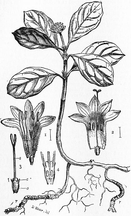
Ipecacuanha Plant (about 1⁄3 nat. size). 1, 2, Flowers cut open, showing short-styled (1) and long-styled (2) forms; 3, Flower after removal of corolla, showing the inferior ovary (o), the small toothed calyx (c), and the style (s) with its forked stigma; 4, Ovary cut lengthwise showing the two chambers with the basally attached ovules; r, annulated root.
Ipecacuanha root occurs in pieces about 2 or 3 lines in thickness, of a greyish-brown or reddish-brown tint externally, having a ringed or annulated surface (see r in fig.), and exhibiting a white or greyish interior and a hard wiry centre. It has a faint rather musty odour, and a bitterish taste. It is usually mixed with more or less of the slender subterranean stem, which has a very thin bark, and is thus easily distinguished from the root. The activity of the drug resides chiefly in the cortical portion, and hence the presence of the stem diminishes its value. The variety imported from Colombia and known as Cartagena ipecacuanha differs only in its larger size and in being less conspicuously annulated. Ipecacuanha owes its properties to the presence of rather more than 1% of the alkaloid emetine, which, with the exception of traces, occurs only in the cortical portion of the root. It is a white amorphous substance, with the formula C20H30NO5. It has a bitter taste, no odour, and turns yellow when exposed to air and light. There are also present a volatile oil, starch, gum, and a glucoside, which is a modification of tannin and is known as ipecacuanhic acid. The dose of the powdered root is ¼ to 2 grains when an expectorant action is desired, and from 15 to 30 grains when it is given as an emetic, which is one of its most valuable functions. The Pharmacopoeias contain a very large number of preparations of this substance, most of which are standardized. A preparation from which the emetine has been removed, and known as “de-emetized ipecacuanha,” is also in use for cases of dysentery.
When applied to the skin, ipecacuanha powder acts as a powerful irritant, even to the extent of causing pustulation. When inhaled it causes violent sneezing and a mild inflammation of the nasal mucous membrane, resembling a common cold in the head. It has feeble antiseptic properties. Small doses of ipecacuanha act as a stimulant to the secretions of the mouth, stomach, intestine and liver. The drug, therefore, increases appetite and aids digestion. Toxic doses cause gastro-enteritis, cardiac failure, dilatation of the blood-vessels, severe bronchitis and pulmonary inflammation closely resembling that seen in ordinary lobar pneumonia. In this respect and in its action on the skin, the drug resembles tartar emetic. Ipecacuanha is very frequently used as an expectorant in cases in which the bronchial secretion is deficient. Its diaphoretic properties are employed in the pulvis ipecacuanhae compositus or Dover’s powder, which contains one part of ipecacuanha powder and one part of opium in ten.
Other plants to which the name of ipecacuanha has been popularly applied are American ipecacuanha (Gillenia stipulacea), wild ipecacuanha (Euphorbia Ipecacuanha), bastard ipecacuanha (Asclepias curassavica), Guiana ipecacuanha (Boerhavia decumbens), Venezuela ipecacuanha (Sarcostemma glaucum), and ipecacuanha des Allemands (Vincetoxicum officinale). All these possess emetic properties to a greater or less degree.
The term poaya is applied in Brazil to emetic roots of several genera belonging to the natural orders Rubiaceae, Violaceae and Polygalaceae, and hence several different roots have from time to time been sent over to England as ipecacuanha; but none of them possesses the ringed or annulated appearance of the true drug. Of these the roots of Ionidium Ipecacuanha, Richardsonia scabra and Psychotria emetica are those which have most frequently been exported from Brazil or Colombia.
1 The name is the Portuguese form of the native word i-pe-kaa-guéne, which is said to mean “road-side sick-making plant” (Skeat, Etym. Dict. 1898).
IPEK (Slav. Petch, Lat. Pescium), a town of Albania, European Turkey, in the vilayet of Kossovo and sanjak of Novibazar, 73 m. E.N.E. of Scutari, near the eastern base of the Mokra Planina, the Montenegrin frontier, and the headwaters of the Ibar and White Drin. Pop. (1905), about 15,000, principally Albanians and Serbs. A small stream bearing, like several others in the Balkan peninsula, the name of Bistritza (the bright or clear), flows through the town. On one of the neighbouring heights is situated the monastery of Ipek, founded by Archbishop Arsenius in the 13th century, and famous as the seat until 1690 of the patriarchs of the Servian church. The buildings are surrounded by thick walls, and comprise a large central church (Our Lady’s), and two side chapels (the Martyrs’ and St Demetrius’), each surmounted by a leaden cupola. The church dates from the 16th and 17th centuries. Among its numerous objects of interest are the white marble tombs of Arsenius and other chiefs of the Servian church, and the white marble throne on which the patriarchs were crowned. Ipek has been incorrectly identified by some writers with Doclea or Dioclea (Duklé in Montenegro), the birthplace of Diocletian, and the capital of a small principality which was overthrown by the Bulgarians in the 11th century.
See Barth, Reise durch das Innere der europäischen Turkei (Berlin, 1864); A. P. Irby and G. M. M. Mackenzie, Travels in the Slavonic Provinces of Turkey (1877); M. E. Durham, Through the Lands of the Serb (London, 1904).
IPHICRATES, Athenian general, son of a shoemaker, flourished in the earlier half of the 4th century B.C. He owes his fame as much to the improvements which he made in the accoutrements of the peltasts or light-armed mercenaries (so called from their small round shield, πέλτη) as to his military successes. Increasing the length of their javelins and swords, substituting linen corselets for their heavy coats-of-mail, and introducing the use of a kind of light leggings, called after him “iphicratides,” he increased greatly the rapidity of their movements (Diod. Sic. xv. 44). He also paid special attention to discipline, drill and manœuvres. With his peltasts Iphicrates seriously injured the allies of the Lacedaemonians in the Corinthian War, and in 392 (or 390) dealt the Spartans a heavy blow by almost annihilating a mora (battalion of about 600 men) of their famous hoplites (Diod. Sic. xiv. 91; Plutarch, Agesilaus, 22). Following up his success, he took city after city for the Athenians; but in consequence of a quarrel with the Argives he was transferred from Corinth to the Hellespont, where he was equally successful. After the peace of Antalcidas (387) he assisted Seuthes, king of the Thracian Odrysae, to recover his kingdom, and fought against Cotys, with whom, however, he subsequently concluded an alliance. About 378 he was sent with a force of mercenaries to assist the Persians to reconquer Egypt; but a dispute with Pharnabazus led to the failure of the expedition (Diod. Sic. xv. 29-43). On his return to Athens he commanded an expedition in 373 for the relief of Corcyra, which was besieged by the Lacedaemonians (Xenophon, Hellenica, vi. 2). On the peace of 371, Iphicrates returned to Thrace, and somewhat tarnished his fame by siding with his father-in-law Cotys in a war against Athens for the possession of the entire Chersonese. The Athenians, however, soon pardoned him and gave him a joint command in the Social War. He and two of his colleagues were impeached by Chares, the fourth commander, because they had refused to give battle during a violent storm. Iphicrates was acquitted but sentenced to pay a heavy fine. He afterwards remained at Athens (according to some he retired to Thrace) till his death (about 353).
There is a short sketch of his life by Cornelius Nepos; see also C. Rehdantz, Vitae Iphicratis, Chabriae et Timothei (1854); Bauer, Griech. Kriegsaltert. in Müller’s Handbuch, 4, § 49; and histories of Greece, e.g. Holm, Eng. trans., vol. iii.
IPHIGENEIA, or Iphianassa, in Greek legend, daughter of Agamemnon and Clytaem(n)estra. Agamemnon had offended Artemis, who prevented the Greek fleet from sailing for Troy, and, according to the soothsayer Calchas, could be appeased only by the sacrifice of Agamemnon’s daughter. According to some accounts the sacrifice was completed, according to others Artemis carried away the maiden to be her priestess in the Tauric Chersonese [Crimea] and substituted for her a hind. In this new country it was her duty to sacrifice to the goddess all strangers; and as her brother Orestes came to search for her and to carry off to Attica the image of the goddess, she was about to sacrifice him, when a happy recognition took place. These legends show how closely the heroine is associated with the cult of Artemis, and with the human sacrifices which accompanied it in older times before the Hellenic spirit had modified the barbarism of this borrowed religion. Orestes and Iphigeneia fled, taking with them the image; at Delphi they met Electra, the sister of Orestes, who having heard that her brother had been sacrificed by the Tauric priestess, was about to tear out the eyes of Iphigeneia. The brother and sister returned to Mycenae; Iphigeneia deposited the image in the deme of Brauron in Attica, where she remained as priestess of Artemis Brauronia. Attica being one of the chief seats of the worship of Artemis, this explains why Iphigeneia is sometimes called a daughter of Theseus and Helen, and thereby connected with the national hero. The grave of Iphigeneia was shown at Brauron and Megara. According to other versions of the legend, when saved from sacrifice Iphigeneia was transported to the island of Leuke, where she was wedded to Achilles under the name of Orsilochia (Antoninus Liberalis 27); or she was transformed by Artemis into the goddess Hecate (Pausanias i. 43. 1). According to the Spartans, the image of Artemis was transported by Orestes and Iphigeneia to Laconia, where the goddess was worshipped as Artemis Orthia, the human sacrifices originally offered to her being abolished by Lycurgus and replaced by the flogging of youths (diamastigosis, Pausan. iii. 16). At Hermione, Artemis was worshipped under the name of Iphigeneia, thus showing the heroine in the last resort to be a form of that goddess (Pausanias ii. 35. 1). Originally, Iphigeneia, the “mighty born,” is probably merely an epithet of Artemis, in which the notion of a priestess of the goddess had its origin. Iphigeneia is a favourite subject in Greek literature. She is the heroine of two plays of Euripides, and of many other tragedies which have been lost (see also Pindar, Pythia xi. 23; Ovid, Metam. xii. 27). In ancient vase paintings she is frequently met with; and the picture by Timanthes representing Agamemnon hiding his face at her sacrifice was one of the famous works of antiquity (Pliny, Nat. Hist. xxxv. 10).
See M. Jacobson, De fabulis ad Iphigeniam pertinentibus (1888); R. Förster, Iphigenie (1898); H. W. Stoll in Roscher’s Lexikon der Mythologie; and P. Decharme in Daremberg and Saglio’s Dictionnaire des antiquités.
IPSWICH, a town of Stanley county, Queensland, Australia, on the river Bremer, 23½ m. by rail W. by S. of Brisbane. Pop. (1901), 8637. It is the centre of a rich and populous agricultural mining and manufacturing district. Coal is worked on the banks of the river with but little labour, as it crops out on the surface. There are a woollen factory, several saw-mills, and foundries and large railway workshops at North Ipswich. The first settlement was made here in 1829; the town was incorporated in 1860.
IPSWICH, a municipal, county and parliamentary borough and county town of Suffolk, England, 69 m. N.E. by E. from London by the Great Eastern railway. Pop. (1901), 66,630. It stands on a gentle ascent above the left bank of the river Gipping, which here widens into the tidal estuary of the Orwell. This land-locked inlet extends 11 m. S.E. to Harwich and Felixstowe at opposite sides of its mouth, near which the wider Stour estuary unites with it. Its banks are gently undulating, well wooded and picturesque. In the lower and older portion of Ipswich, with its irregular streets, are some few antiquarian remains. Sparrowe’s house (1567), named from a family which occupied it for some two centuries, is well preserved and has ornate gabled fronts to two streets. Archdeacon’s Place (1471) is another still earlier example. Wolsey’s Gateway (1528), a Tudor brick building, is the only remnant of the Cardinal’s foundation to supply scholars to his great college (Cardinal’s College, now Christ Church) at Oxford. The older churches are all towered flint-work structures, wholly or mainly Perpendicular in style, with the exception of St Peter’s, which is principally Decorated, with a Norman font of marble. They include St Margaret’s with a beautiful oak Tudor roof, elaborately painted temp. William and Mary; St Mary-at-Key (or Quay), with a similar roof; St Lawrence; and St Clement’s. The most noteworthy modern churches are St Michael’s (1880), All Saints’ (1892), St John the Baptist’s (1899) and St Bartholomew’s (1901). The Roman Catholic church of St Pancras (1863), a late First Pointed edifice, has a richly carved reredos and a lofty flèche. Among public buildings, the town hall (1868) is an imposing structure in Venetian style, with clock tower; forming part of a fine group including the corn exchange (1881) and post office (1880). The museum, including an art gallery, contains archaeological and ornithological collections, and a noteworthy series of Red Crag fossils. It was founded in 1847, and moved to new buildings in 1881. The East Suffolk hospital was founded in 1836. In the theatre David Garrick made his first important and regular appearance in 1741. The grammar school, dating at latest from 1477, was refounded by Queen Elizabeth in 1565, and is housed in buildings in Tudor style (1851). There are borough science, art and technical schools, with a picture gallery in the fine Tudor mansion (1549) in Christchurch Park. There are also a middle school for boys, a high school and an endowed school for girls, a scientific society, corporation library and small medical library. Of two beautiful arboretums the upper is public; part of Christchurch Park adjacent to this is owned by the corporation; there are also recreation grounds and a race-course. Industries include large engineering and agricultural implement works, railway plant works, the making of artificial manures, boots and shoes, clothing, bricks and tobacco and malting. The port has a dock of nearly 30 acres, accommodating vessels drawing 19 ft. and a large extent of quayage. Imports are principally grain, timber and coal; exports agricultural machinery, railway plant, artificial manures, oil cake, &c. Ipswich is a suffragan bishopric in the diocese of Norwich. The parliamentary borough returns two members. The corporation consists of a mayor, 10 aldermen and 30 councillors. Area, 8112 acres.
A Roman villa has been discovered here. But the Saxon settlement at the head of the Orwell was doubtless the first of any importance. In 991 the town (Gipeswic, Gipeswich) was sacked by vikings. It owes its subsequent prosperity to its situation on a harbour admirably suited for trade with the Continent. The townsmen had acquired the privileges of burgesses by 1086 when Roger Bigot kept the borough in the king’s hands. In 1200 King John granted the burgesses their first charter, confirming their town to them to be held at fee-farm, exempting them from tolls and similar customs, and granting them a gild-merchant. These liberties were extended in 1256; Edward I. and Edward III. both resumed the borough for short periods, but the charter of 1200 was confirmed by almost every subsequent sovereign. The burgesses were definitely incorporated in 1464 and re-incorporated in 1665 under a charter which remained in force previous to its modification by the Municipal Act of 1835, except during a short period in the reign of Charles II. From 1295 onwards the town has sent two representatives to parliament. The cattle market, held on Tuesdays, and the provision market on Saturdays are the prescriptive right of the corporation. A September fair, still held in 1792, was in the hands of the corporation in the 17th century. Large ironworks were established late in the 18th century. The wool and cloth trade which flourished here in the 14th and 15th centuries was superseded by the manufacture of sailcloth, now represented by the sacking industry.
See Victoria County History: Suffolk; J. Wodderspoon, Memorials of the Ancient Town of Ipswich (ed. 1850).
IPSWICH, a township of Essex county, Massachusetts, U.S.A., on both sides of the Ipswich river, about 27 m. N.N.E. of Boston. Pop. 1910 (Federal census), 5777. It is served by the Boston & Maine railroad. The surface is diversified by drumlins, vales, meadows, sand-dunes and tidal marshes. Ipswich has several manufacturing industries, including hosiery. The public library was the gift of Augustine Heard. Among the residences are several built in the 17th and 18th centuries. The oldest of these, the John Whipple House, is the home of the Ipswich Historical Society (1890), which has gathered here a collection of antiques and issues publications of antiquarian interest. In the Ipswich Female Seminary, which no longer exists, Mary Lyon taught from 1828 to 1834 and here planned Mount Holyoke Seminary; Professor J. P. Cowles and his wife conducted a famous school for girls in the building for many years. Facing the South Common were the homes of Rev. Nathaniel Ward (1578-1652), principal author of the Massachusetts “Body of Liberties” (1641), the first code of laws in New England, and author of The Simple Cobler of Aggawam in America, Willing to help mend his Native Country, lamentably tattered, both in the upper-Leather and the Sole (1647), published under the pseudonym, “Theodore de la Guard,” one of the most curious and interesting books of the colonial period; of Richard Saltonstall (1610-1694), who wrote against the life tenure of magistrates, and although himself an Assistant espoused the more liberal principles of the Deputies; and of Ezekiel Cheever (1614-1708), a famous schoolmaster, who had charge of the grammar school in 1650-1660. In the vicinity was the house of the Rev. William Hubbard (1621-1704), author of a Narrative of the Troubles with the Indians in New England (Boston, 1677) and a general History of New England, published by the Massachusetts Historical Society in 1815.
The town was founded under the name of Aggawam in 1633 by John Winthrop, jun., and twelve others, with a view to preventing the French from occupying the N. part of Massachusetts, and in the next year it was incorporated under its present name. In wealth and influence during the early colonial period it was little inferior to Boston, whose policies it not infrequently opposed. When Governor Andros and his Council in 1687 issued an order for levying a tax, a special town meeting of Ipswich promptly voted “that the s’d act doth infringe their Liberty as Free borne English subjects of His Majestie by interfearing with ye statutory Laws of the Land, By which it is enacted that no taxes shall be levied on ye Subjects without consent of an assembly chosen by ye Freeholders for assessing the same,” and refused to assess the tax. For this offence six leaders, headed by the Rev. John Wise, minister of the Chebacco Parish (now Essex), were prosecuted, found guilty, imprisoned for three weeks to await sentence and then disqualified for office; they were also fined from £15 to £50 each, and were required to give security for their good behaviour. In Ipswich were originally included the present townships of Hamilton (1793) and Essex (1819).
See T. F. Waters, Ipswich in the Massachusetts Bay Colony 1633-1700 (Ipswich, 1905), and the publications of the Ipswich Historical Society.
IQUIQUE, a city and port of Chile, capital of the province of Tarapacá, 820 m. N. of Valparaiso, in 20° 12′ 15″ S., 70° 11′ 15″ W. Pop. (1895), 33,031; (1900, est.), 42,440. The coast here runs due N. and S. and the city is built on a narrow level plain between the sea and bluffs, the latter rising steeply 2000 ft. to the level of the great desert plain of Tarapacá, celebrated for its rich deposits of nitrate of soda. Facing the city is the low barren island of Serrano, or Iquique, which is connected with the mainland by a stone causeway 1500 ft. long, and shelters the anchorage from southerly storms. A mole extending from the N.E. end of the island affords some further protection. The city is laid out in the rectangular plan, with broad streets and large squares. Water is brought by pipes from Pica, 50 m. distant. Iquique is a city of much commercial importance and is provided with banks, substantial business houses, newspapers, clubs, schools, railways, tramways, electric lights, telephone lines, and steamship and cable communication with the outside world. It exports iodine and immense quantities of nitrate of soda obtained from the desert region of the province. A large number of vessels are engaged in the nitrate trade, and Iquique ranks as one of the two leading ports of Chile in the aggregate value of its foreign commerce. It is connected by rail with the inland town of Tarapacá and various mining centres, and through them with the ports of Pisagua on the N., and Patillos on the S. Iquique was an insignificant Peruvian fishing settlement until 1830 when the export of nitrate began. In 1868 the town was nearly destroyed by an earthquake, in 1875 by fire, and again in 1877 by earthquakes, a fire and a tidal wave. It was occupied by the Chileans in 1879 in the war between Chile and Peru, and was ceded to Chile by the treaty of the 20th of October 1883.
IQUITOS, a tribe of South American Indians. It is divided into many branches, some on the river Tigre, others on the Nanay. Missionary efforts have failed and they remain savages, worshipping figures carved in the shape of birds and beasts. They brew the Indian fermented liquor chicha better than any of the neighbouring tribes, flavouring it with the shoots of some plant which has the effect of an opiate.
IQUITOS, a city and river port of Peru, and capital of the great inland department of Loreto, on the left bank of the upper Amazon near the mouth of the Rio Nanay, 87 m. below the mouth of the Ucayali and 930 m. from Puerto Bermudez. The geographical position of Iquitos is 3° 44′ S., 73° W. Pop. of the city (1906, est.), 6000; of the district (1906, est.), 12,000. Iquitos stands about 348 ft. above sea-level, on the low wooded banks of the river opposite some islands of the same name, and has a warm but healthful climate (mean annual temperature, about 78° F.). The city consists of two pueblos, the larger of which is occupied by Indians and half-breeds, the descendants of the Iquitos tribe from whom the city takes its name. The opening of the Amazon to navigation, and the subsequent arrival of foreign ocean-going vessels at Iquitos, added immensely to the importance of the city, and made it the commercial entrepôt of eastern Peru. In 1908 three lines of ocean-going steamers were making regular voyages up the Amazon to Iquitos (about 2500 m.). The city has a large import and export trade for an immense region watered by the Marañon, Huallaga, Ucayali and other large Amazonian rivers navigated from Iquitos by lines of small boats. Iquitos was put in wireless telegraphic communication with Puerto Bermudez on the 8th of July 1908, whence a land line runs across the Andes to Lima. Besides machine shops and shipbuilding facilities, the important industries are the weaving of hats and hammocks, and the preparation of salt fish; and there is a considerable export of rubber and straw hats. Tobacco is produced in the vicinity and sent to other parts of the Montaña region. Iquitos dates officially from 1863, when it had a population of 431, though there had been a white settlement there for more than half a century.
IRAK, a province of Persia, situated W. of Kum and Kashan and E. of Burujird, and paying a yearly revenue of about £16,000. The province has many flourishing villages which produce much grain, but its greatest income is derived from the carpets made in many of its villages and mostly exported to Europe, the value of which is estimated at about £100,000 per annum. An important British firm is established at Sultanabad, the capital of the province, solely for this trade. Sultanabad is situated 77 m. S.W. of Kum in 34° 6′ N. and 49° 42′ E. at an elevation of 5925 ft. It has a population of about 8000 and post and telegraph offices. It was founded in 1808 and made a recruiting centre for some battalions of infantry which were to form part of the reorganized Persian army as recommended by the chief of the French mission, General Gardane. In consequence of its recent foundation it is still occasionally spoken of as Shahr-i-no, the “new city.”
IRAK-ARABI (’Iraq-Arabi, “Arab Irak”), the name employed since the Arab conquest to designate that portion of the valley of the Tigris and Euphrates known in older literature as Babylonia. Irak is approximately the region below the Median Wall, from Opis on the Tigris, at the mouth of Shatt-el-Adhem, to the neighbourhood of Ramadieh (Ramadiya) on the Euphrates; that is, from nearly latitude 34° to the Persian Gulf, and from the Syrian desert to the Persian mountains. It consists of two unequal portions, an extensive dry steppe with a healthy desert climate, and an unhealthy region of swamps. There is a good deal more agriculture along the Euphrates than along the Tigris, but swamps are at the same time much more extensive along the former. The borders of both streams wherever there is habitation are lined with date-palms. This is especially true of the lower part of Irak in the Basra vilayet, where the date-palm forms dense groves bordering the banks for a distance of many days’ journey. A luxuriant vegetation of water plants is to be found in the swamps, which are the haunt of numerous wild beasts—pigs, lions, different kinds of aquatic animals and birds. These swamps are inhabited by a wild race of men, dark of hue, with many negroes among them, who cultivate rice and weave straw mats. Their chiefs, with their wives and a very few retainers or members of their immediate families, live in mud castles; the tribesmen live in rude huts of reeds and mats about these castles. In the main these swamp-dwellers, who designate themselves Ma‘-dan, keep pretty free both of the Turkish government and of the semi-Bedouins of Irak. Some of them are very lawless, especially the inhabitants of the region below the Shatt-el-Haī, between the two rivers. Here the Turkish government exercises no authority, and the tribesmen of the swamps play pirate on the merchandise passing up and down the Euphrates above Korna, where for some 80 m. the river has been allowed to form an immense swamp. Some of the Bedouin tribes also engage in marauding expeditions and terrorize certain portions of the country. Especially troublesome are the edh-Dhafir, westward of the Euphrates, opposite the mouth of the Shatt-el-Haī, and the Beni Lam (7500 tents strong) who occupy the country east of the Tigris to the south of Bagdad. Still more difficult of control is the great tribe of Shammar, who descend every year from the north, pitching their tents in the Jezireh (i.e. the region between the two rivers) southward of Bagdad, and terrifying the whole country during their stay. The Turkish government is, however, gradually extending its authority over all Irak partly by force, partly by treachery. The Affech nation, Ma‘-dan Arabs, occupying the swamps behind Diwanieh between the Tigris and Euphrates, and the great Montefich tribes, Bedouins who claimed the whole country southward of the Affech to the Shatt-el-Haī and beyond, have since 1880 been deprived gradually of their power and a considerable part of their independence. In 1903 the Turkish government transferred the capital of the sanjak of Hillah to Diwanieh opposite the Affech swamps, and there is now a line of towns, centres of Turkish power and Turkish force, extending southward from Ana to Nasrieh, at the mouth of the Shatt-el-Haī canal, while similar stations are being established or strengthened along the Tigris. Some important steps have also been taken by the Turkish government to control the Euphrates floods, and to drain the swamps in some sections of the country, especially westward of the Euphrates. A dam was built at the mouth of the Hindieh canal to prevent the waters of the Euphrates from losing themselves as heretofore in the swamps westward, and to assure a continual supply of water in the main bed of the Euphrates. It is, however, frequently carried away. The ancient Assyrium Stagnum, or Bahr Nejef near the town of that name, with other swamps formed by the overflow of the Hindieh, have been drained and turned into rice plantations. At the same time large sections of Irak have been converted into imperial domain, to the diminution of the revenues of the country but to the increase of the prosperity of the population which inhabits that domain. Something, though not very much, has thus been done to restore the land to its ancient fertility.
Ethnographically Irak is subject to a double influence. On the one hand the connexion with Nejd, the centre plateau of Arabia, continues uninterrupted, even the ’Agel Bedouins from central Arabia having a quarter of their own in Bagdad. Many of these Arabs come to Irak merely for a temporary residence, returning later to their homes with the earnings acquired in that comparatively rich country; but a considerable number remain permanently. Even stronger than the influence of Arabia is that of Persia. In general the inhabitants of Irak are Shi’ites not Sunnites, and their religious connexion and allegiance is therefore toward Persia, not Turkey. Persian customs are in fashion, Persian coinage is used equally with the Turkish, and in some parts, more especially in Bagdad, there is an important Persian quarter, while Kerbela and Meshed ‘Ali to the west of the Euphrates are really Persian enclaves in Turkish territory. No traces remain of that rich intellectual development which was produced in the time of the caliphs through the reciprocal action of Persian and Arabic elements. Still, the quick-wittedness of the inhabitants of Irak makes a decided impression on the traveller passing through Asiatic Turkey. Throughout Irak also Indian influence is visible in not a few particulars. In the hot summer months, for instance, when the natives live in those underground apartments called serdab, the Indian punkah is used in the houses of the rich. There are also small Indian colonies at most of the large towns and a considerable trade with India is carried on, especially in horses.
The trade of Irak is even now not unimportant. The principal exports from Basra are dates, various grains, millet seed, rice and wool, while the imports consist chiefly of Manchester goods, lumber, petroleum, coal and household necessities. Besides this there is a considerable land commerce by caravan, of which Bagdad is the centre. The total value of the exports of Irak according to the official figures of the Turkish government amounts to nearly £2,000,000, while the imports of every kind reach the value of about £1,800,000. If the ancient system of irrigation were restored and the land restored to cultivation, the country could support five hundred times as many inhabitants as it usually contains. Steamboats navigate the Tigris only as far as Bagdad, and that with great difficulty. In general, communication by water is carried on by means of the most primitive craft. Goods are transported in the so-called turradas, moderately big high-built vessels, which also venture out into the Persian Gulf as far as Kuwet. Passengers are conveyed, especially on the Euphrates, in the meshhuf, a very long narrow boat, mostly pushed along the river bank with poles or towed by ropes. The Mesopotamian kelleks, rafts laid on goat-skin bladders, come down the Tigris as far as Bagdad. At Bagdad round boats made of plaited reeds pitched with asphalt, the so-called kufas (qufas), are used. At Basra the bellems are in use, boats of large size, having the appearance of being hollowed out of tree trunks and partly in fact so constructed. There are no roads, and the extensive swamps and periodic inundations which lay large sections under water render land traffic by caravan somewhat uncertain.
Irak in general is an alluvial plain, formed by the deposits of the rivers Tigris and Euphrates, with a few scattered reaches of sand appearing here and there. The mass of solid matter which the rivers deposit is very considerable. The maximum proportion for the Euphrates in the month of January is 1⁄80 and at other times 1⁄200; for the Tigris the maximum is 1⁄100. In general, the northern plains of the interior have a slight but well-defined southerly inclination, with local depressions. The territory undulates in the central districts, and then sinks away into mere marshes and lakes. The clay, of a deep blue colour, abounds with marine shells, and shows a strong efflorescence of natron and sea-salt. When the soil is parched the appearance of the mirage (serab) is very common. As extensive inundations in spring are caused by both the rivers, especially the Tigris, great changes must have taken place in this part of the country in the course of thousands of years. It has been asserted that in former times the alluvial area at the mouth of the river increased 1 m. in the space of thirty years; and from this it has been assumed that about the 6th century B.C. the Persian Gulf must have stretched from 45 to 55 m. farther inland than at present. The actual rate of increase at the present time is about 72 ft. per annum. While we may be unable to determine accurately the former physical configuration of southern Babylonia, it is at least certain that in Babylonian times the Euphrates and Tigris reached the sea as independent rivers, and Ritter estimates that in the time of Alexander the Great the embouchures were still separated by a good day’s journey. Although they cannot now be traced, great alterations have probably taken place also in the upper portions of the rivers as well as in the country near their mouths. The names of a large number of canals occur in the old Babylonian inscriptions, as in the works of the Arabian geographers, but while some of these have been traced it has not been possible hitherto to identify the greater number of them with actually existing canals or remains of canals. To the west of the Euphrates, on the edge of the Syrian desert from Hit downward to the neighbourhood of Basra and beyond, ran the Sa’ade, now for the most part dry, a very ancient canal, extended or enlarged at different periods. Lower down near Mussaib, the Hindieh canal, at least equal in volume to the present main stream, branches off and after traversing and irrigating an extensive territory rejoins the river at Samawa. Between the Euphrates and the Tigris, there was a large number of great canals, especially in the region northward of Babylon between that city and the northern edge of the alluvial plain, of which the most famous were the ‘Isa, the Sarsar, the Malk (“Royal”), the canal of Kutha, the Sura and the Arakhat (Shatt-en-Nil). Of these only one at present carries water, namely, the Nahr ‘Isa, which, leaving the Euphrates at Sakhlawieh (Sakh lawiya), terminates in extensive marshes near Bagdad; but this is now no longer navigable. Southward of Babylon the Daghara canal, which leaves the Euphrates a little below Hillah and empties into the Affech marshes, and the Shatt-el-Kehr, which, leaving that stream a little above Diwanieh, makes a great curve through the interior of the Jezireh, finally losing itself in the Hosainieh (Hosainiya) marshes near the mouth of the Shatt-el-Haï, are the only navigable or partly navigable canals of the Euphrates in the Jezireh. The Tigris canals are not so numerous as those of the Euphrates and were not so famous in history, but eastward of that river the great Nahrawan channel still exists in part, while the Tigris is connected with the Euphrates by a navigable stream, the Shatt-el-Haï, which leaves the former river at Kut-el-’Amara and enters the Euphrates at Nasrieh. Everywhere the country is intersected with ancient canals, some still deep dry beds, other so silted up that their course is represented only by parallel lines of hillocks. Some of these, of great antiquity, like the Shatt-en-Nil, which can be traced through its whole course from Babylon, through or past Nippur, Udnun (Bismya) Gishban (Gis-ukh), Erech and Larsa, to the Hosainieh marshes, were equally as important as the Euphrates itself; and indeed it may be said that in ancient times that stream after reaching the alluvial plain was divided into a large number of channels, partly natural partly artificial, no single one of which, but all together, constituted the Euphrates. By the restoration of these old canals, traces of which are met with at every step, the country might be again raised to that condition of high civilization which it enjoyed not only in antiquity but even as late as the time of the caliphs. The classical writers are unanimous in their admiration of Babylonia, and it is certain that nowhere else in the ancient world was the application of canals to the exigencies of agriculture worked out so successfully as here. The most luxuriant vegetation was diffused over the whole country and three crops were obtainable in the year. In the matter of civilization indeed no country of the ancient world surpassed. Babylonia. How densely peopled this country once was may be gathered from the fact that about 794 B.C., 89 fortified towns and 820 smaller places in the Chaldaean region were captured during one military expedition. And even in the times of the caliphs there stood on the royal canal and its branches, north of Babylon, 360 villages, contributing in gold 225,000 dirhems to the state treasury besides the tax in kind. To-day the whole region from the swamps about Basra northward is dotted with ruin mounds, and at places the plain itself is strewn for miles with fragments of glass and pottery, evidence of earlier occupation, while, as stated, lines of canals of all possible sizes, from the great triple canals with four rows of parallel hillocks, down to the small canals for purposes of irrigation, intersect the country in every direction.
There seem to have been almost from the outset two centres which strove with one another for political supremacy in this region, the south and the north. In the north in the Babylonian time lay Kish, Akkad, Kutha (Tell-Ibrahim), Sippara (Abu Habba), Babylon and Borsippa (Birs-Nimrud). In the south were Eridu and Ur (Mughair)—originally on the shores of the Persian Gulf, now 125 m. inland—Erech (Warka), Larsa (Senkereh), Lagash (Tello) and Gishban (Yokha). Nearly in the centre lay Nippur and Udnun (Bismya). Besides these there were numerous other cities, some of considerable importance, which are known to us at present only by name; and there are in Irak hundreds of ruin mounds, some of them of considerable size, covering ancient Babylonian cities, the greater part of which are still unexplored and unidentified. During the period of Greek domination a Greek city, Seleucia (q.v.), which afterwards attained great prosperity, was founded by Seleucus I. in an extremely favourable situation on the right bank of the Tigris. Greek cities were founded also in the south, at the head of the Persian Gulf, and some of the ancient Babylonian cities of the interior like Lagash, Erech and Nippur, were rebuilt on the old sites. After the conquest of Babylonia by the Parthians (130 B.C.) Ctesiphon (q.v.) was built on the east bank of the Tigris opposite Seleucia, and became the winter residence of the Persian kings. Later this double city became the imperial capital of the Sassanids, and under the name Madain still continued to flourish after the Arabic conquest, to be finally superseded by the neighbouring Bagdad. That region was called in the time of the Sassanids, Suristan, a translation of the Aramaean designation Beth-Aramaya, “country of the Syrians,” for the land was mainly occupied by Aramaeans. By a notable substitution the Arabs afterwards gave the name Nabat, i.e. Nabataeans, to these Aramaean tenantry, who it may be added were already found in these parts at the time of the Babylonian empire. Indeed, some small portion of this old Syrian population of Irak still remains distinguished by a special religion (see Mandaeans), chiefly on the shores of the lower Euphrates in the neighbourhood of Suk-esh-Sheiukh. Another important city of the Sassanian period was Perisabora, known in the Arabian period as Anbar, the centre also of Babylonian Judaism after the destruction of Pombeditha in A.D. 588, situated on the east bank of the Euphrates in about the same latitude as Bagdad. During the Sassanian period flourished in the south-east the Arabic kingdom of Hira (q.v.). There was also for a time a Jewish kingdom in Babylonia, and Nehardea and Pombeditha are mentioned as centres of Jewish religions and national life during this period.
After the Arabian conquest in the 7th century A.D., Irak entered for a time on a new period of prosperity. Several important new cities were founded, among them Kufa, Basra, Wasit on the Shatt-el-Haï, and Bagdad on the site of an old Babylonian city of the same name, which later became under the Abbasid caliphs not only the capital of Irak but for a time the metropolis of the world (see Caliphate). With the decay of the Abbasid power the system of irrigation began to fall into disrepair, the ancient sites were gradually deserted, and the country finally returned to a condition of semi-barbarism alternating between inundation and drought, which is its present state.
See Ritter, Die Erdkunde von Asien, 2nd ed., vol. vii., 10th and 11th parts (Berlin, 1843, 1844); W. F. Ainsworth, Researches in Assyria (London, 1838); F. R. Chesney, Expedition for the Survey of the Rivers Euphrates and Tigris (2 vols., London, 1850); W. K. Loftus, Chaldaea and Susiana (1857); F. Delitzsch, Wo lag das Paradies? (Leipzig, 1881); W. F. Ainsworth, The Euphrates Expedition (1888); J. P. Peters, Nippur (1897); E. Sachau, Am Euphrat und Tigris (1900); F. Delitzsch, Im Lande des einstigen Paradieses (1903). Maps: Chesney (1850); Selby, Bewsher and Collingwood (1871); Kiepert, Ruinenfelder (1883).
(A. So.; J. P. Pe.)
IRAK-I-AJAMI (i.e. Persian Irak), the name (now obsolete) of the important Persian province which the Arab geographers called Jebel (the mountainous region). It used to be the country bounded N. by Azerbaijan and Gílán, E. by Samnan and the central Persian desert, S. by Kerman, Fars and Arabistan, W. by Kermanshah and Kurdistan. Its length, N.W.-S.E., was about 600 m. from the Kaflán Kuh on the Kizil Uzain, the frontier of Azerbaijan, to the frontier of Kerman beyond Yezd, and its width, N.E.-S.W., about 300 m.
IRAN, the great plateau between the plain of the Tigris in the west and the valley of the Indus in the east, the Caspian Sea and the Turanian desert in the north, and the Persian Gulf and the Indian Ocean in the south, surrounded on all sides by high mountain ranges with a great salt desert in the centre. The modern name Iran, in middle-Persian Eran (a form preferred by many German authors) is derived from the ancient Aryāna, “the country of the Aryans,” i.e. that part of the Aryans which we call Iranians. Eratosthenes limited the name of Ariana to the south-eastern part of Iran, and excluded Persia, Media and Bactria, and therein he is followed by Strabo (ii. 78, 130, xv. 720 ff.; Pomp. Mela i. 3; Pliny, Nat. Hist. vi. 113, 116, xii. 33); Pliny (Nat. Hist. vi. 93) confounds it with Arīa, Areia, Pers. Haraiva, i.e. the district of Herat; but Strabo himself says (xv. 724) that some extended the name to the Persians, Medes, Bactrians and Sogdians, as they all spoke the same language with small dialectic variations (cf. 727 and i. 66, xi. 523).
For the ethnography and history of Iran see Persia.
(Ed. M.)
IRBIT, a town of Russia, in the government of Perm, 110 m. N.E. of Ekaterinburg, and on the Irbit river. Pop. (1860) 3408, (1897) 20,064. It is famous for a great fair, held since 1643, which lasts from the 1st of February to the 1st of March (O.S.), and at which are sold (to an average annual value of over £4,000,000) cottons, woollens, flax and hemp, silks, leather, metals, metallic and other manufactured goods, furs, hides, felt, raw wool and tea.
IRELAND, JOHN (1761-1842), English divine and dean of Westminster, was born at Ashburton, Devonshire, on the 8th of September 1761, his father being a butcher in that town. For a short time he worked in a shoemaker’s shop. Subsequently he proceeded to Oxford, and in due course took holy orders. Through the interest of the earl of Liverpool he was in 1802 appointed a prebendary of Westminster Abbey, in 1815 he was promoted to the deanery of Westminster, and from 1816 to 1835 he was also rector of Islip, Oxfordshire. In 1825 he gave £4000 for the foundation at Oxford of four “Ireland” scholarships of the value of £30 a year each, “for the promotion of classical learning and taste.” He also gave £500 to Westminster school for the establishment of prizes for Latin hexameters. He died at Westminster on the 2nd of September 1842, and was buried in the abbey.
IRELAND, JOHN (1838- ), American Roman Catholic prelate, was born at Burnchurch, County Kilkenny, Ireland, on the 11th of September 1838. In 1849 he was taken to the United States by his parents, who settled at St Paul, Minnesota Territory. After being educated in France for the priesthood, he returned to the United States in 1861; he was ordained at St Paul and in the following year he accompanied the 5th Minnesota Volunteer Infantry south as chaplain. Subsequently he became rector of the cathedral at St Paul, and in 1870-1871 represented Bishop Thomas Langdon Grace (1814-1897) at the Vatican council at Rome. In 1875 he was appointed bishop of Nebraska, but at the urgent request of Bishop Grace the appointment was changed so that he might remain at St Paul as bishop-coadjutor with the right of succession; at the same time he was made titular bishop of Maronea. In 1884 he succeeded to the bishopric, and in 1888 he became the first archbishop of the see. His liberal views gave him a wide influence and reputation both within and without the church, and he came to be looked upon as a leader of the “American” as distinguished from the “Roman” party in the clergy. His views were, however, opposed by several leading Catholics; and several of his administrative acts, notably his plan for the partial taking over of control of the parochial schools by the local authorities (known from the town in which it was first attempted, “the Faribault plan”), were strenuously attacked. He was prominently identified with the planting of Catholic communities or colonies in the North-West, with the establishment of the Catholic University at Washington, and with the Catholic total abstinence movement. The degree of LL.D. was conferred on him by Yale University in 1901. He published The Church and Modern Society (1896).
IRELAND, WILLIAM HENRY (1777-1835), forger of Shakespearian manuscripts, was born in London in 1777. His father, Samuel Ireland, was an engraver and author, and dealer in rare books and curios. In 1794 young Ireland, with his father, visited Stratford, where he met John Jordan, a local poet who had published a deal of gossipy matter about Shakespeare and had even forged the will of the poet’s father. Seeing his own father’s credulous interest, Ireland conceived the idea of doing a little forgery on his own account. He copied, in ink which had all the signs of age, Shakespeare’s style and handwriting, and produced leases, contracts with actors, notes, receipts, a profession of faith, and even a love letter to Anne Hathaway with an enclosed lock of hair, to the delight of his unsuspecting father, and the deception of many scholars who attested their belief in the genuineness of his finds. These he accounted for by inventing an ancestor “William Henrye Irelaunde,” to whom they had been bequeathed by Shakespeare in gratitude for rescue from drowning. At last the discovery of a whole new play named Vortigern was announced. Sheridan purchased it for Drury Lane Theatre, and an overflowing house assembled on the 2nd of April 1796 to sit in judgment upon it. But away from the glamour of crabbed handwriting and yellow paper, the feeble dialogue and crude conceptions of the tragedy could not stand the test, and its one representation was greeted with shouts of laughter. Its fate prevented the composition of a series of historical plays, of which Henry II. had already been produced by this audacious forger. Samuel Ireland the elder had published in 1795 the Miscellaneous Papers and Legal Instruments under the Hand and Seal of William Shakespeare; including the Tragedy of King Lear and a small fragment of Hamlet (dated 1796). He had the fullest belief in their authenticity, but the hostile criticism of Malone and others, and the unsatisfactory account of the source of the papers, made him demand a full disclosure from his son. Harassed by the success of his own deceit, which had carried him far beyond his first intention, Ireland at last confessed his fraud, and published (1796) an Authentic Account of the Shakespearian MSS., and in 1805, a more elaborate Confession, entirely exculpating his father and making a full admission. The elder Ireland felt the disgrace very bitterly, and it probably hastened his death, which occurred in July 1800. After the exposure Ireland was forced to abandon both his home and his profession. He wrote several novels of no value, gradually sank into penury, and died on the 17th of April 1835.
The more interesting publications on the Ireland forgeries are: Inquiry into the authenticity of certain Papers, &c., attributed to Shakespeare, by Edmond Malone (1796); the elder Ireland’s Vindication of his Conduct (1796); An Apology for the Believers in the Shakespeare Papers (1797), and a Supplemental Apology (1799), both by George Chalmers; and pamphlets by Boaden, Waldron, Wyatt, Webb and Oulton. Vortigern was republished in 1832. The elder Ireland’s correspondence with regard to the forgeries is preserved in the British Museum, with numerous specimens of his son’s talent. Ireland’s career supplied the subject-matter of James Payn’s novel The Talk of the Town (1885).