VOLUME XI SLICE VII Geoponici to Germany (part) (continued 7)
Reading edition
Industries.—Agriculture is followed by the natives in the northern districts, but the chief industry is stock-raising. The scarcity of water in the southern parts is not favourable for agricultural pursuits, while the good grazing lands offer splendid pasturage for cattle, which the Herero raise in numbers amounting to many hundred thousands. Sheep and goats thrive well. Horses have been imported from the Cape. Unfortunately the climate does not suit them everywhere, and they are subject to a virulent distemper. Cattle and sheep also suffer from the diseases which are common in the Cape Colony. Camels have been imported, and are doing well. Wheat, maize and sorghum are the chief crops raised, though not enough is grown to meet even local requirements. Near the coast the natives collect the kernels of the nara, a wild-growing pumpkin which, in the words of an early traveller, C.J. Andersson, “are eaten by oxen, mice, men, ostriches and lions.” About half the European settlers are engaged in agriculture. They raise maize, wheat, tobacco, fruit and vegetables. Cotton cultivation and viticulture are carried on in some districts.
Minerals, especially copper, are plentiful in the country. The chief copper deposits are at Tsumeb, which is 4230 ft. above the sea, in the Otavi district. Diamonds are found on and near the surface of the soil in the Lüderitz Bay district, and diamonds have also been found in the neighbourhood of Gibeon. A little pottery is made, and the Hottentot women are clever in making fur cloths. In the north the Ovampo do a little smith-work and grass-plaiting. The external trade of the country was of slow growth. The exports, previous to the opening up of the Otavi mines, consisted chiefly of live stock—sent mainly to Cape Colony—guano, ivory, horns, hides and ostrich feathers. The chief imports are food stuffs, textiles and metals, and hardware. In 1903 the value of the exports was £168,560, that of the imports £388,210. The war which followed (see below, History) led to a great shrinking of exports, rendering the figures for the period 1904-1907 useless for purposes of comparison. About 85% of the imports are from Germany.
Communications.—The economic development of the country is largely dependent on transport facilities. The railway from Swakopmund to Windhoek, mentioned above, was begun in 1897, and was opened for traffic in July 1902. It cost nearly £700,000 to build. Another narrow gauge railway, to serve the Otavi copper mines, was begun in 1904 and completed in 1908. It starts from Swakopmund and is 400 m. long, the terminus being at Grootfontein, 40 m. S.E. of Tsumeb. The highest point on this line is 5213 ft. above the sea. In 1906-1908 a railway, 180 m. long, was built from Lüderitz Bay to Keetmanshoop. This line is of the standard South African gauge (3 ft. 6 in.), that gauge being adopted in view of the eventual linking up of the line with the British railway systems at Kimberley. A branch from Seeheim on the Keetmanshoop line runs S.E. to Kalkfontein.
Besides railways, roads have been made between the chief centres of population. Along these, in the desert districts, wells have been dug. Across the Awas Mountains, separating Windhoek from the central plateau, a wide road has been cut. In 1903 the colony was placed in telegraphic communication with Europe and Cape Colony by the laying of submarine cables having their terminus at Swakopmund. There is a fairly complete inland telegraphic service.
There is regular steamship communication between Hamburg and Swakopmund, Walfish Bay and Lüderitz Bay. Regular communication is also maintained between Cape Town and the ports of the colony.
Administration.—At the head of the administration is an imperial governor, responsible to the colonial office in Berlin, who is assisted by a council consisting of chiefs of departments. The country is divided into various administrative districts. In each of these there is a Bezirksamtmann, with his staff of officials and police force. In each district is a law court, to whose jurisdiction not alone the whites, but also the Bastaards are subject. As in all German colonies, there is a court of appeal at the residence of the governor. The government maintains schools at the chief towns, but education is principally in the hands of missionaries. The armed force consists of regular troops from Germany and a militia formed of Bastaards. The local revenue for some years before 1903 was about £130,000 per annum, the expenditure about £400,000, the difference between local receipts and expenditure being made good by imperial subsidies. In 1908 local revenue had risen to £250,000, but the imperial authorities incurred an expenditure of over £2,000,000, largely for military purposes. On articles of export, such as feathers and hides, 5% ad valorem duty has to be paid; on cattle and horses an export tax per head. There is a 10% ad valorem duty on all imports, no difference being made between German and foreign goods. The sale of spirituous liquors is subject to a licence.
History.—The coast of south-west Africa was discovered by Bartholomew Diaz in 1487, whilst endeavouring to find his way to the Indies. He anchored in a bay which by reason of its smallness he named Angra Pequena. Portugal, however, took no steps to acquire possession of this inhospitable region, which remained almost unvisited by Europeans until the early years of the 19th century. At this time the country was devastated by a Hottentot chief known as Afrikander, who had fled thither with a band of outlaws after murdering his master, a Boer farmer by whom he had been ill-treated, in 1796. In 1805 some missionaries (of German nationality) went into Namaqualand in the service of the London Missionary Society, which society subsequently transferred its missions in this region to the Rhenish mission, which had had agents in the country since about 1840. The chief station of the missionaries was at a Hottentot settlement renamed Bethany (1820), a place 125 m. E. by Angra Pequena. The missionaries had the satisfaction of stopping Afrikander’s career of bloodshed. He became a convert, a great friend of the mission, and took the name of Christian. The proximity of Great Namaqualand to Cape Colony led to visits from British and Dutch farmers and hunters, a few of whom settled in the country, which thus became in some sense a dependency of the Cape.
In 1867 the islands along the coast north and south of Angra Pequena, on which were valuable guano deposits, were annexed to Great Britain. At this time a small trade between the natives and the outside world was developed at Angra Pequena, the merchants engaged in it being British and German. The political influence of the Cape spread meantime northward to the land of the Herero (Damara). The Herero had been subjugated by Jonker Afrikander, a son of Christian Afrikander, who followed the early footsteps of his sire and had renounced Christianity, but in 1865 they had recovered their independence. The Rhenish missionaries appealed (1868) to the British government for protection, and asked for the annexation of the country. This request, although supported by the Prussian government, was refused. In 1876, however, a special commissioner (W. Coates Palgrave) was sent by the Cape government “to the tribes north of the Orange river.” The commissioner concluded treaties with the Namaqua and Damara which fixed the limits of the territories of the two races and placed the whole country now forming German South-West Africa within the sphere of British influence. In the central part of Damaraland an area of some 35,000 sq. m. was marked out as a British reservation. The instrument by which this arrangement was made was known as the treaty of Okahandya. Neither it nor the treaty relating to Great Namaqualand was ratified by the British government, but at the request of Sir Bartle Frere, then high commissioner for South Africa, Walfish Bay (the best harbour along the coast) was in 1878 annexed to Great Britain.
In 1880 fighting between the Namaqua, who were led by Jan Afrikander, son of Jonker and grandson of Christian Afrikander, and the Damara broke out afresh, and was not ended until the establishment of European rule. In German rule established. 1883 F.A.E. Lüderitz (1834-1886), a Bremen merchant, with the approval of Prince Bismarck, established a trading station at Angra Pequena. This step led to the annexation of the whole country to Germany (see Africa, § 5) with the exception of Walfish Bay and the islands actually British territory. On the establishment of German rule Jonker Afrikander’s old headquarters were made the seat of administration and renamed Windhoek. The Hottentots, under a chieftain named Hendrik Witboi, offered a determined opposition to the Germans, but after a protracted war peace was concluded in 1894 and Hendrik became the ally of the Germans. Thereafter, notwithstanding various local risings, the country enjoyed a measure of prosperity, although, largely owing to economic conditions, its development was very slow.
In October 1903 the Bondelzwarts, who occupy the district immediately north of the Orange river, rose in revolt. This act was the beginning of a struggle between the Germans and the natives which lasted over four years, and cost Herero war. Germany the lives of some 5000 soldiers and settlers, and entailed an expenditure of £15,000,000. Abuses committed by white traders, the brutal methods of certain officials and the occupation of tribal lands were among the causes of the war, but impatience of white rule was believed to be the chief reason for the revolt of the Herero, the most formidable of the opponents of the Germans. The Herero had accepted the German protectorate by treaty—without fully comprehending that to which they had agreed. To crush the Bondelzwarts, an object attained by January 1904, the governor, Colonel Theodor Leutwein, had denuded Damaraland of troops, and advantage was taken of this fact by the Herero to begin a long-planned and well-prepared revolt. On the 12th of January 1904 most of the German farmers in Damaraland were attacked, and settlers and their families murdered and the farms devastated. Reinforcements were sent from Germany, and in June General von Trotha arrived and took command of the troops. On the 11th of August von Trotha attacked the Herero in their stronghold, the Waterberg, about 200 m. N. of Windhoek, and inflicted upon them a severe defeat. The main body of the enemy escaped, however, from the encircling columns of the Germans, and thereafter the Herero, who were under the leadership of Samuel Maherero, maintained a guerrilla warfare, rendering the whole countryside unsafe. The Germans found pursuit almost hopeless, being crippled by the lack of water and the absence of means of transport. To add to their troubles a Herero bastard named Morenga, with a following of Hottentots, had, in July, recommenced hostilities in the south. On the 2nd of October 1904 von Trotha, exasperated at his want of success in crushing the enemy, issued a proclamation in which he said: “Within the German frontier every Herero with or without a rifle, with or without cattle, will be shot. I will not take over any more women and children. But I will either drive them back to your people or have them fired on.” In a later order von Trotha instructed his soldiers not to fire into, but to fire over the heads of the women and children, and Prince Bülow ordered the general to repeal the whole proclamation. Whenever they had the chance, however, the Germans hunted down the Herero, and thousands perished in the Omaheke desert, across which numbers succeeded in passing to British territory near Ngami.
On the day following the issue of von Trotha’s proclamation to the Herero, i.e. on the 3rd of October 1904, Hendrik Witboi sent a formal declaration of war to the Germans. Hendrik had helped to suppress the Bondelzwarts rising, and had received a German decoration for his services, and his hostility is said to have been kindled by the supersession of Colonel Leutwein, for whom he entertained a great admiration. The Witbois were joined by other Hottentot tribes, and their first act was to murder some sixty German settlers in the Gibeon district. Both British and Boer farmers were spared—the Hottentots in this matter following the example of the Herero. In November, considerable reinforcements having come from Germany, the Witbois were attacked, and Hendrik’s headquarters, Reitmont, captured. Another defeat was inflicted on Hendrik in January 1905, but, lacking ammunition and water, the Germans could not follow up their victory. As in Damaraland, the warfare in Namaqualand now assumed a guerrilla character, and the Germans found it almost impossible to meet their elusive enemy, while small detachments were often surprised and sometimes annihilated. In May 1905 von Trotha tried the effect on the Hottentots of another of his proclamations. He invited them to surrender, adding that in the contrary event all rebels would be exterminated. A price was at the same time put on the heads of Hendrik Witboi and other chiefs. This proclamation was unheeded by the Hottentots, who were in fact continuing the war with rifles and ammunition seized from the Germans, and replenishing their stock with cattle taken from the same source. In the north, however, Samuel Maherero had fled to British territory, and the resistance of the Herero was beginning to collapse. Concentration camps were established in which some thousands of Herero women and children were cared for. Meanwhile, the administration of von Trotha, who had assumed the governorship as well as the command of the troops, was severely criticized by the civilian population, and the non-success of the operations against the Hottentots provoked strong military criticism. In August 1905 Colonel (afterwards General) Leutwein, who had returned to Germany, formally resigned the governorship of the protectorate, and Herr von Lindequist, late German consul-general at Cape Town, was nominated as his successor. Von Trotha, who had publicly criticized Prince Bülow’s order to repeal the Herero proclamation, was superseded. He had in the summer of 1905 instituted a series of “drives” against the Witbois, with no particular results. Hendrik always evaded the columns and frequently attacked them in the rear.
In November 1905 von Lindequist arrived at Windhoek. The new governor issued a general amnesty to the Herero, and set aside two large reserves for those who surrendered. His conciliatory policy was in the end successful, and the Ovampo, who threatened to give trouble, were kept in hand. The task of pacifying Damaraland was continued throughout 1906, and by the close of that year about 16,000 Herero had been established in the reserves. Some 3000 had sought refuge in British territory, while the number who had perished may be estimated at between 20,000 and 30,000.
In Namaqualand von Lindequist found an enemy still unbroken. On the 3rd of November, however, Hendrik Witboi died, aged seventy-five, and his son and successor Samuel Isaac Witboi shortly afterwards surrendered, and the The Hottentots subdued. hostility of the tribe ceased. Morenga now became the chief of the rebel Hottentots, and “drives” against him were organized. Early in May 1906 an encounter between Morenga and a German column was fought close to the British frontier of the Bechuanaland protectorate. Morenga fled, was pursued across the frontier, and wounded, but escaped. On the 16th of May he was found hiding by British patrols and interned. Other Hottentot chiefs continued the conflict, greatly aided by the immense difficulty the Germans had in transporting supplies; to remedy which defect the building of a railway from Lüderitz Bay to Kubub was begun early in 1906. A camel transport corps was also organized, and Boer auxiliaries engaged. Throughout the later half of 1906 the Hottentots maintained the struggle, the Karas mountains forming a stronghold from which their dislodgment was extremely difficult. Many of their leaders and numbers of the tribesmen had a considerable strain of white (chiefly Dutch) blood and were fairly educated men, with a knowledge not only of native, but European ways; facts which helped to make them formidable opponents. Gradually the resistance of the Hottentots was overcome, and in December 1906 the Bondelzwarts again surrendered. Other tribes continued the fight for months longer, but by March 1907 it was found possible to reduce the troops in the protectorate to about 5000 men. At the height of the campaign the Germans had 19,000 men in the field.
In August 1907 renewed alarm was created by the escape of Morenga from British territory. The Cape government, regarding the chief as a political refugee, had refused to extradite him and he had been assigned a residence near Upington. This place he left early in August and, eluding the frontier guards, re-entered German territory. In September, however, he was again on the British side of the border. Meantime a force of the Cape Mounted Police under Major F.A.H. Eliott had been organized to effect his arrest. Summoned to surrender, Morenga fled into the Kalahari Desert. Eliott’s force of sixty men pursued him through a waterless country, covering 80 m. in 24 hours. When overtaken (September 21st), Morenga, with ten followers, was holding a kopje and fired on the advancing troops. After a sharp engagement the chief and five of his men were killed, the British casualties being one killed and one wounded. The death of Morenga removed a serious obstacle to the complete pacification of the protectorate. Military operations continued, however, during 1908. Herr von Lindequist, being recalled to Berlin to become under-secretary in the colonial office, was succeeded as governor (May 1907) by Herr von Schuckmann. In 1908 steps were taken to establish German authority in the Caprivi enclave, which up to that time had been neglected by the colonial authorities.
The discovery of diamonds in the Lüderitz Bay district in July 1908 caused a rush of treasure-seekers. The diamonds were found mostly on the surface in a sandy soil and were of small size. The stones resemble Brazilian Discovery of diamonds. diamonds. By the end of the year the total yield was over 39,000 carats. One of the difficulties encountered in developing the field was the great scarcity of fresh water. During 1909 various companies were formed to exploit the diamondiferous area. The first considerable packet of diamonds from the colony reached Germany in April 1909. The output for the year was valued at over £1,000,000.
Authorities.—Karl Dove, Deutsch-Südwestafrika (Berlin, 1903); W. Külz, Deutsch-Südafrika ... (Berlin, 1909); T. Leutwein, Elf Jahre Gouverneur in Deutsch-Südwestafrika (Berlin, 1908), an authoritative work, largely historical; P. Rohrbach, Deutsche Kolonialwirtschaft, Band 1: Südwestafrika (Berlin, 1907), a comprehensive economic study; I. Irle, Die Herero, ein Beitrag zur Landes-, Volks- und Missionskunde (Gütersloh, 1906), a valuable summary of information concerning Damaraland; Major K. Schwabe, Im deutschen Diamantenlande (Berlin, 1909); T. Rehbock, Deutsch-Südwestafrika, seine wirtschaftliche Erschliessung unter besonderer Berücksichtigung der Nutzbarmachung des Wassers (Berlin, 1898); C. von François, Deutsch-Südwestafrika: Geschichte der Kolonisation bis zum Ausbruch des Krieges mit Witbooi, April 1893 (Berlin, 1899), a history of the protectorate up to 1893; H. Schintz, Deutsch-Südwestafrika, Forschungsreisen durch die deutschen Schutzgebiete Gross-Nama und Hereroland, nach dem Kunene, &c., 1884-1887 (Oldenburg, N.D. [1891]); H. von François, Nama und Damara (Magdeburg, N.D. [1896]). See also for Ethnology, “Die Eingeborenen Deutsch-Südwestafrikas nach Geschichte, Charakter, Sitten, Gebräuchen und Sprachen,” in Mitteilungen des Seminars für orientalische Sprachen (Berlin and Stuttgart) for 1899 and 1900; and G.W. Stow, The Native Races of South Africa (London, 1905); ch. xvii. contains an account of the Afrikander family. For geology consult A. Schenk, “Die geologische Entwicklung Südafrikas (mit Karte),” Peterm. Mitt. (1888); Stromer von Reichenbach, Die Geologie der deutschen Schutzgebiete in Afrika (Munich and Leipzig, 1896). Of early books of travel the most valuable are: F. Galton, Tropical South Africa (1853; new ed. 1889); Charles J. Andersson, Lake Ngami (1856), The Okavango River (1861) and Notes of Travel (1875). See also Sir J.E. Alexander, An Expedition of Discovery into the Interior of Africa (London, 1838). Reports on the German colonies are published by the British foreign office. The Kriegskarte von Deutsch-Südwestafrika (Berlin, 1904), in nine sheets on a scale of 1 : 800,000, will be found useful.
(F. R. C.)
1 As the result of wars with the natives, the population greatly decreased. The number of adult (native) males in the colony at the beginning of 1908 was officially estimated at 19,900, a figure indicating a total population of little more than 100,000.
GERMANTOWN, a residential district and former suburb, now the Twenty-second Ward, of Philadelphia, Pennsylvania, U.S.A., on Wissahickon Creek, in the N. part of the city. It is served by the Pennsylvania and the Philadelphia & Reading railways. There are many old colonial houses and handsome modern residences along Main Street (the old Germantown Road or Avenue). Prominent among the historic houses is Cliveden, or the “Chew House,” built about 1761 by Benjamin Chew (1722-1810), who was chief-justice of Pennsylvania in 1774-1777 and was imprisoned as a Loyalist in 1777, and whose home during the battle of Germantown (see below) was occupied by British troops. The well-preserved Morris House (1772) was the headquarters of General Howe at the close of the battle, and in 1793, when Germantown, owing to the yellow fever in Philadelphia, was the temporary capital of the United States, it was occupied by President Washington. Three doors above stood until 1904 the Ashmead House, used for a time by Count Nicholas Lewis Zinzendorf and his daughters for their Moravian school, which was removed to Bethlehem. In the same street, opposite Indian Queen Lane, is the old Wister Mansion, built as a country-seat in 1744 and occupied by British officers during the War of Independence. In another old house (now Nos. 5275-5277), John Fanning Watson (1779-1860), the annalist of Philadelphia, did most of his literary work. Just outside the ward limits, in what has since become a part of Fairmont Park, is the house in which David Rittenhouse, the astronomer, was born; it stands on Monoshore Creek or Paper Mill Run, in what was long called Roxborough (now the 21st ward of Philadelphia). In this vicinity the first paper mill in America was erected in 1690 by a company of which William Rittenhouse, David’s great-grandfather, was the leading member. The King of Prussia Inn, built about 1740, and the Mermaid Hotel, as old or older, are interesting survivals of the inns and taverns of old Germantown. The Germantown Academy was built in 1760, and after the battle of Germantown was used by the British as a hospital. In Germantown are also a Friends’ (orthodox) school, a Friends’ free library, and the Germantown branch of the Philadelphia public library. The first school in Germantown was established about 1701, and for the first eighteen years was under the mastership of Francis Daniel Pastorius (1651-1719), the leader in founding the town, who lived in a house that stood on the site of the present First Methodist Episcopal church, High Street and Main Street. He compiled a primer which was the first school book produced in the state; with three others he drafted and signed in 1688 what seems to have been the first public protest made in America against slavery; and he is celebrated in Whittier’s Pennsylvania Pilgrim. Later the same school passed to Christopher Dock (d. 1771), who in 1770 published an essay on teaching (written in 1750), which is said to have been the first book on pedagogy published in America. The first Bible printed in America in any European language was published in Germantown in 1743 by Christopher Sauer (d. 1758), a preacher of the German Baptist Brethren, who in 1739 established Germantown’s first newspaper, The High German Pennsylvania Historian, or Collection of Important News from the Kingdom of Nature and of the Church. His grandsons are said to have cast about 1772 the first American printing type. The Friends were the first sect to erect a meeting-house of their own (about 1693). The Mennonites built a log meeting-house in 1709, and their present stone church was built in 1770. The town hall of Germantown was used as a hospital during the last three years of the Civil War. In Market Square a soldiers’ monument was erected in 1883. The Site and Relic Society of Germantown maintains a museum of relics. Many of the early settlers were linen weavers, and Germantown still manufactures textiles, knit goods and yarns.
Germantown was founded in October 1683 by thirteen families from Crefeld, Germany, under the leadership of Francis Daniel Pastorius. The township, as originally laid out, contained four distinct villages known as Germantown, Cresheim, Sommerhousen and Crefield. Cresheim was later known as Mount Airy, and Sommerhousen and Crefield became known as Chestnut Hill. The borough of Germantown was incorporated in 1689. For many years it was a straggling village extending about 2 m. along Main Street. Its growth was more rapid from the middle of the 18th century. In 1789 a motion for the permanent location of the national capital at Germantown was carried in the Senate, and the same measure passed the House, amended only with respect to the temporary government of the ceded district; but the Senate killed the bill by voting to postpone further consideration of it until the next session. Germantown was annexed to Philadelphia in 1854.
Battle of Germantown.—This famous encounter in the American War of Independence was fought on the 4th of October 1777. After the battle of Brandywine (q.v.) and the occupation of Philadelphia, the British force commanded by Sir W. Howe encamped at Germantown, where Washington determined to attack them. The Americans advanced by two roads, General Sullivan leading the column on the right and General Greene that on the left. Washington himself accompanied Sullivan, with whom were Stirling (an officer who claimed to be earl of that name) and Anthony Wayne. The right at first met with success, driving the British advanced troops back on the main body near the Chew House. Colonel Musgrave, of the 40th Foot, threw a portion of his regiment into this house, and General Agnew came up with his command. The Americans under Stirling attempted to dislodge Musgrave, thus losing time and alarming part of Sullivan’s advance who had pushed farther forward in the fog. General Greene on the left was even less fortunate. Meeting with unexpected opposition at the first point of attack his troops were thrown into confusion and compelled to retreat. One of his brigades extended itself to the right wing, and by opening fire on the Chew House caused Wayne to retreat, and presently both of the American columns retired rapidly in the direction of their camp. The surprise had failed, with the loss to Washington’s army of 673 men as against 500 on the side of the British. The British General Agnew and the American General Nash were both mortally wounded. In December Washington went into winter quarters at Valley Forge, 40 m. west of Philadelphia. The British wintered in and around the city.
See N.H. Keyser, “Old Historic Germantown,” in the Proceedings and Addresses of the Pennsylvania-German Society (Lancaster, 1906); S.W. Pennypacker, The Settlement of Germantown, Pennsylvania, and the Beginning of German Emigration to North America (Philadelphia, 1899), and S.F. Hotchkin, Ancient and Modern Germantown, Mount Airy and Chestnut Hill (Philadelphia, 1889).
GERMANY (Ger. Deutschland), or, more properly, The German Empire (Deutsches Reich), a country of central Europe. The territories occupied by peoples of distinctively Teutonic race and language are commonly designated as German, and in this sense may be taken to include, besides Germany proper (the subject of the present article), the German-speaking sections of Austria, Switzerland and Holland. But Germany, or the German empire, as it is now understood, was formed in 1871 by virtue of treaties between the North German Confederation and the South German states, and by the acquisition, in the peace of Frankfort (May 10, 1871), of Alsace-Lorraine, and embraces all the countries of the former German Confederation, with the exception of Austria, Luxemburg, Limburg and Liechtenstein. The sole addition to the empire proper since that date is the island of Heligoland, ceded by Great Britain in 1890, but Germany has acquired extensive colonies in Africa and the Pacific (see below, Colonies).
The German empire extends from 47° 16′ to 55° 53′ N., and from 5° 52′ to 22° 52′ E. The eastern provinces project so far that the extent of German territory is much greater from south-west to north-east than in any other direction. Tilsit is 815 m. from Metz, whereas Hadersleben, in Schleswig, is only 540 m. from the Lake of Constance. The actual difference in time between the eastern and western points is 1 hour and 8 minutes, but the empire observes but one time—1 hour E. of Greenwich. The empire is bounded on the S.E. and S. by Austria and Switzerland (for 1659 m.), on the S.W. by France (242 m.), on the W. by Luxemburg, Belgium and Holland (together 558 m.). The length of German coast on the North Sea or German Ocean is 293 m., and on the Baltic 927 m., the intervening land boundary on the north of Schleswig being only 47 m. The eastern boundary is with Russia 843 m. The total length of the frontiers is thus 4569 m. The area, including rivers and lakes but not the haffs or lagoons on the Baltic coast, is 208,830 sq. m., and the population (1905) 60,641,278. In respect of its area, the German empire occupied in 1909 the third place among European countries, and in point of population the second, coming in point of area immediately after Russia and Austria-Hungary, and in population next to Russia.
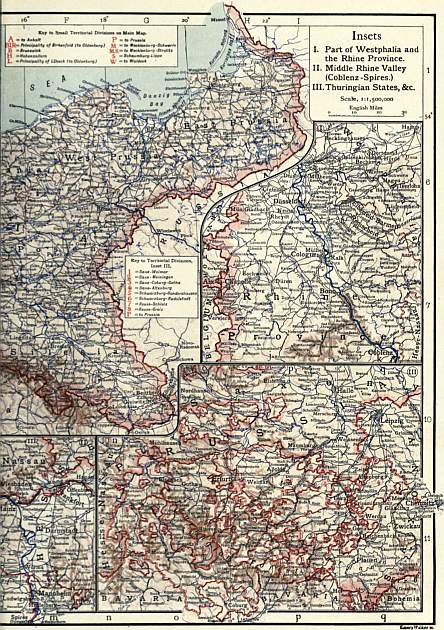
Political Divisions.—The empire is composed of the following twenty-six states and divisions: the kingdoms of Prussia, Bavaria, Saxony and Württemberg; the grand-duchies of Baden, Hesse, Mecklenburg-Schwerin, Mecklenburg-Strelitz, Oldenburg and Saxe-Weimar; the duchies of Anhalt, Brunswick, Saxe-Altenburg, Saxe-Coburg-Gotha and Saxe-Meiningen; the principalities of Lippe-Detmold, Reuss-Greiz, Reuss-Schleiz, Schaumburg-Lippe, Schwarzburg-Rudolstadt, Schwarzburg-Sondershausen and Waldeck-Pyrmont; the free towns of Bremen, Hamburg and Lübeck, and the imperial territory of Alsace-Lorraine.
Besides these political divisions there are certain parts of Germany which, not conterminous with political boundaries, retain appellations derived either from former tribal settlements or from divisions of the old Holy Roman Empire. These are Franconia (Franken), which embraces the districts of Bamberg, Schweinfurt and Würzburg on the upper Main; Swabia (Schwaben), in which is included Württemberg, parts of Bavaria and Baden and Hohenzollern; the Palatinate (Pfalz), embracing Bavaria west of the Rhine and the contiguous portion of Baden; Rhineland, applied to Rhenish Prussia, Nassau, Hesse-Darmstadt and parts of Bavaria and Baden; Vogtland,1 the mountainous country lying in the south-west corner of the kingdom of Saxony; Lusatia (Lausitz), the eastern portion of the kingdom of Saxony and the adjacent portion of Prussia watered by the upper Spree; Thuringia (Thüringen), the country lying south of the Harz Mountains and including the Saxon duchies; East Friesland (Ost Friesland), the country lying between the lower course of the Weser and the Ems, and Westphalia (Westfalen), the fertile plain lying north and west of the Harz Mountains and extending to the North Sea and the Dutch frontier.
Coast and Islands.—The length of the coast-line is considerably less than the third part of the whole frontier. The coasts are shallow, and deficient in natural ports, except on the east of Schleswig-Holstein, where wide bays encroach upon the land, giving access to the largest vessels, so that the great naval harbour could be constructed at Kiel. With the exception of those on the east coast of Schleswig-Holstein, all the important trading ports of Germany are river ports, such as Emden, Bremen, Hamburg, Lübeck, Stettin, Danzig, Königsberg, Memel. A great difference, however, is to be remarked between the coasts of the North Sea and those of the Baltic. On the former, where the sea has broken up the ranges of dunes formed in bygone times, and divided them into separate islands, the mainland has to be protected by massive dikes, while the Frisian Islands are being gradually washed away by the waters. On the coast of East Friesland there are now only seven of these islands, of which Norderney is best known, while of the North Frisian Islands, on the western coast of Schleswig, Sylt is the most considerable. Besides the ordinary waste of the shores, there have been extensive inundations by the sea within the historic period, the gulf of the Dollart having been so caused in the year 1276. Sands surround the whole coast of the North Sea to such an extent that the entrance to the ports is not practicable without the aid of pilots. Heligoland is a rocky island, but it also has been considerably reduced by the sea. The tides rise to the height of 12 or 13 ft. in the Jade Bay and at Bremerhaven, and 6 or 7 ft. at Hamburg. The coast of the Baltic, on the other hand, possesses few islands, the chief being Alsen and Fehmarn off the coast of Schleswig-Holstein, and Rügen off Pomerania. It has no extensive sands, though on the whole very flat. The Baltic has no perceptible tides; and a great part of its coast-line is in winter covered with ice, which also so blocks up the harbours that navigation is interrupted for several months every year. Its haffs fronting the mouths of the large rivers must be regarded as lagoons or extensions of the river beds, not as bays. The Pommersche or Oder Haff is separated from the sea by two islands, so that the river flows out by three mouths, the middle one (Swine) being the most considerable. The Frische Haff is formed by the Nogat, a branch of the Vistula, and by the Pregel, and communicates with the sea by means of the Pillauer Tief. The Kurische Haff receives the Memel, called Niemen in Russia, and has its outlet in the extreme north at Memel. Long narrow alluvial strips called Nehrungen, lie between the last two haffs and the Baltic. The Baltic coast is further marked by large indentations, the Gulf of Lübeck, that of Pomerania, east of Rügen, and the semicircular Bay of Danzig between the promontories of Rixhöft and Brüsterort. The German coasts are well provided with lighthouses.
Surface.—In respect of physical structure Germany is divided into two entirely distinct portions, which bear to one another a ratio of about 3 to 4. The northern and larger part may be described as a uniform plain. South and central Germany, on the other hand, is very much diversified in scenery. It possesses large plateaus, such as that of Bavaria, which stretches away from the foot of the Alps, fertile low plains like that intersected by the Rhine, mountain chains and isolated groups of mountains, comparatively low in height, and so situated as not seriously to interfere with communication either by road or by railway.
Bavaria is the only division of the country that includes within it any part of the Alps, the Austro-Bavarian frontier running along the ridge of the Northern Tirolese or Bavarian Alps. The loftiest peak of this group, the Zugspitze (57 m. S. of Mountains and plateaus. Munich), is 9738 ft. in height, being the highest summit in the empire. The upper German plain sloping northwards from the Bavarian Alps is watered by the Lech, the Isar and the Inn, tributaries of the Danube, all three rising beyond the limits of German territory. This plain is separated on the west from the Swiss plain by the Lake of Constance (Bodensee, 1306 ft. above sea-level), and on the east from the undulating grounds of Austria by the Inn. The average height of the plain may be estimated at about 1800 ft., the valley of the Danube on its north border being from 1540 ft. (at Ulm) to 920 ft. (at Passau). The plain is not very fertile. In the upper part of the plain, towards the Alps, there are several lakes, the largest being the Ammersee, the Würmsee or Starnberger See and the Chiemsee. Many portions of the plain are covered by moors and swamps of large extent, called Moose. The left or northern bank of the Danube from Regensburg downwards presents a series of granitic rocks called the Bavarian Forest (Bayrischer Wald), which must be regarded as a branch of the Bohemian Forest (Böhmer Wald). The latter is a range of wooded heights on the frontier of Bavaria and Bohemia, occupying the least known and least frequented regions of Germany. The summits of the Bayrischer Wald rise to the height of about 4000 ft., and those of the Böhmer Wald to 4800 ft., Arber being 4872 ft. The valley of the Danube above Regensburg is flanked by plateaus sloping gently to the Danube, but precipitous towards the valley of the Neckar. The centre of this elevated tract is the Rauhe Alb, so named on account of the harshness of the climate. The plateau continuing to the north-east and then to the north, under the name of the Franconian Jura, is crossed by the valley of the winding Altmühl, and extends to the Main. To the west extensive undulating grounds or low plateaus occupy the area between the Main and the Neckar.
The south-western corner of the empire contains a series of better defined hill-ranges. Beginning with the Black Forest (Schwarzwald), we find its southern heights decline to the valley of the Rhine, above Basel, and to the Jura. The summits are rounded and covered with wood, the highest being the Feldberg (10 m. S.E. of Freiburg, 4898 ft.). Northwards the Black Forest passes into the plateau of the Neckarbergland (average height, 1000 ft.). The heights between the lower Neckar and the Main form the Odenwald (about 1700 ft.); and the Spessart, which is watered by the Main on three sides, is nothing but a continuation of the Odenwald. West of this range of hills lies the valley of the upper Rhine, extending about 180 m. from south to north, and with a width of only 20 to 25 m. In the upper parts the Rhine is rapid, and therefore navigable with difficulty; this explains why the towns there are not along the banks of the river, but some 5 to 10 m. off. But from Spires (Speyer) town succeeds town as far down as Düsseldorf. The western boundary of this valley is formed in the first instance by the Vosges, where granite summits rise from under the surrounding red Triassic rocks (Sulzer Belchen, 4669 ft.). To the south the range is not continuous with the Swiss Jura, the valley of the Rhine being connected here with the Rhone system by low ground known as the Gate of Mülhausen. The crest of the Vosges is pretty high and unbroken, the first convenient pass being near Zabern, which is followed by the railway from Strassburg to Paris. On the northern side the Vosges are connected with the Hardt sandstone plateau (Kalmit, 2241 ft.), which rises abruptly from the plain of the Rhine. The mountains south of Mainz, which are mostly covered by vineyards, are lower, the Donnersberg, however, raising its head to 2254 ft. These hills are bordered on the west by the high plain of Lorraine and the coal-fields of Saarbrücken, the former being traversed by the river Mosel. The larger part of Lorraine belongs to France, but the German part possesses great mineral wealth in its rich layers of ironstone (siderite) and in the coal-fields of the Saar. The tract of the Hunsrück, Taunus and Eifel is an extended plateau, divided into separate sections by the river valleys. Among these the Rhine valley from Bingen to Bonn, and that of the Mosel from Trier to Coblenz, are winding gorges excavated by the rivers. The Eifel presents a sterile, thinly-peopled plateau, covered by extensive moors in several places. It passes westwards imperceptibly into the Ardennes. The hills on the right bank of the Rhine also are in part of a like barren character, without wood; the Westerwald (about 2000 ft.), which separates the valleys of the Sieg and Lahn, is particularly so. The northern and southern limits of the Niederrheinische Gebirge present a striking contrast to the central region. In the south the declivities of the Taunus (2890 ft.) are marked by the occurrence of mineral springs, as at Ems on the Lahn, Nauheim, Homburg, Soden, Wiesbaden, &c., and by the vineyards which produce the best Rhine wines. To the north of this system, on the other hand, lies the great coal basin of Westphalia, the largest in Germany. In the south of the hilly duchy of Hesse rise the isolated mountain groups of the Vogelsberg (2530 ft.) and the Rhön (3117 ft.), separated by the valley of the Fulda, which uniting farther north with the Werra forms the Weser. To the east of Hesse lies Thuringia, a province consisting of the far-stretching wooded ridge of the Thuringian Forest (Thüringerwald; with three peaks upwards of 3000 ft. high), and an extensive elevated plain to the north. Its rivers are the Saale and Unstrut. The plateau is bounded on the north by the Harz, an isolated group of mountains, rich in minerals, with its highest elevation in the bare summit of the Brocken (3747 ft.). To the west of the Harz a series of hilly tracts is comprised under the name of the Weser Mountains, out of which above Minden the river Weser bursts by the Porta Westphalica. A narrow ridge, the Teutoburger Wald (1300 ft.), extends between the Weser and the Ems as far as the neighbourhood of Osnabrück.
To the east the Thuringian Forest is connected by the plateau of the Frankenwald with the Fichtelgebirge. This group of mountains, occupying what may be regarded as ethnologically the centre of Germany, forms a hydrographical centre, whence the Naab flows southward to the Danube, the Main westward to the Rhine, the Eger eastward to the Elbe, and the Saale northward, also into the Elbe. In the north-east the Fichtelgebirge connects itself directly with the Erzgebirge, which forms the northern boundary of Bohemia. The southern sides of this range are comparatively steep; on the north it slopes gently down to the plains of Leipzig, but is intersected by the deep valleys of the Elster and Mulde. Although by no means fertile, the Erzgebirge is very thickly peopled, as various branches of industry have taken root there in numerous small places. Around Zwickau there are productive coal-fields, and mining for metals is carried on near Freiberg. In the east a tableland of sandstone, called Saxon Switzerland, from the picturesque outlines into which it has been eroded, adjoins the Erzgebirge; one of its most notable features is the deep ravine by which the Elbe escapes from it. Numerous quarries, which supply the North German cities with stone for buildings and monuments, have been opened along the valley. The sandstone range of the Elbe unites in the east with the low Lusatian group, along the east of which runs the best road from northern Germany to Bohemia. Then comes a range of lesser hills clustering together to form the frontier between Silesia and Bohemia. The most western group is the Isergebirge, and the next the Riesengebirge, a narrow ridge of about 20 miles’ length, with bare summits. Excluding the Alps, the Schneekoppe (5266 ft.) is the highest peak in Germany; and the southern declivities of this range contain the sources of the Elbe. The hills north and north-east of it are termed the Silesian Mountains. Here one of the minor coal-fields gives employment to a population grouped round a number of comparatively small centres. One of the main roads into Bohemia (the pass of Landshut) runs along the eastern base of the Riesengebirge. Still farther to the east the mountains are grouped around the hollow of Glatz, whence the Neisse forces its way towards the north. This hollow is shut in on the east by the Sudetic group, in which the Altvater rises to almost 4900 ft. The eastern portion of the group, called the Gesenke, slopes gently away to the valley of the Oder, which affords an open route for the international traffic, like that through the Mülhausen Gate in Alsace. Geographers style this the Moravian Gate.
The North German plain presents little variety, yet is not absolutely uniform. A row of low hills runs generally parallel to the mountain ranges already noticed, at a distance of 20 to 30 m. to the north. To these belongs the upper Silesian coal-basin, which occupies a considerable area in south-eastern Silesia. North of the middle districts of the Elbe country the heights are called the Fläming hills. Westward lies as the last link of this series the Lüneburger Heide or Heath, between the Weser and Elbe, north of Hanover. A second tract, of moderate elevation, sweeps round the Baltic, without, however, approaching its shores. This plateau contains a considerable number of lakes, and is divided into three portions by the Vistula and the Oder. The most eastward is the so-called Prussian Seenplatte. Spirdingsee (430 ft. above sea-level and 46 sq. m. in area) and Mauersee are the largest lakes; they are situated in the centre of the plateau, and give rise to the Pregel. Some peaks near the Russian frontier attain to 1000 ft. The Pomeranian Seenplatte, between the Vistula and the Oder, extends from S.W. to N.E., its greatest elevation being in the neighbourhood of Danzig (Turmberg, 1086 ft.). The Seenplatte of Mecklenburg, on the other hand, stretches from S.E. to N.W., and most of its lakes, of which the Müritz is the largest, send their waters towards the Elbe. The finely wooded heights which surround the bays of the east coast of Holstein and Schleswig may be regarded as a continuation of these Baltic elevations. The lowest parts, therefore, of the North German plain, excluding the sea-coasts, are the central districts from about 52° to 53° N. lat., where the Vistula, Netze, Warthe, Oder, Spree and Havel form vast swampy lowlands (in German called Brüche), which have been considerably reduced by the construction of canals and by cultivation, improvements due in large measure to Frederick the Great. The Spreewald, to the S.E. of Berlin, is one of the most remarkable districts of Germany. As the Spree divides itself there into innumerable branches, enclosing thickly wooded islands, boats form the only means of communication. West of Berlin the Havel widens into what are called the Havel lakes, to which the environs of Potsdam owe their charms. In general the soil of the North German plain cannot be termed fertile, the cultivation nearly everywhere requiring severe and constant labour. Long stretches of ground are covered by moors, and there turf-cutting forms the principal occupation of the inhabitants. The greatest extent of moorland is found in the westernmost parts of the plain, in Oldenburg and East Frisia. The plain contains, however, a few districts of the utmost fertility, particularly the tracts on the central Elbe, and the marsh lands on the west coast of Holstein and the north coast of Hanover, Oldenburg and East Frisia, which, within the last two centuries, the inhabitants have reclaimed from the sea by means of immense dikes.
Rivers.—Nine independent river-systems may be distinguished: those of the Memel, Pregel, Vistula (Weichsel), Oder, Elbe, Weser, Ems, Rhine and Danube. Of these the Pregel, Weser and Ems belong entirely, and the Oder mostly, to the German empire. The Danube has its sources on German soil; but only a fifth part of its course is German. Its total length is 1750 m., and the Bavarian frontier at Passau, where the Inn joins it, is only 350 m. distant from its sources. It is navigable as far as Ulm, 220 m. above Passau; and its tributaries the Lech, Isar, Inn and Altmühl are also navigable. The Rhine is the most important river of Germany, although neither its sources nor its mouths are within the limits of the empire. From the Lake of Constance to Basel (122 m.) the Rhine forms the boundary between the German empire and Switzerland; the canton of Schaffhausen, however, is situated on the northern bank of the river. From Basel to below Emmerich the Rhine belongs to the German empire—about 470 m. or four-sevenths of its whole course. It is navigable all this distance as are also the Neckar from Esslingen, the Main from Bamberg, the Lahn, the Lippe, the Ruhr, the Mosel from Metz, with its affluents the Saar and Sauer. Sea-going vessels sail up the Ems as far as Halte, and river craft as far as Greven, and the river is connected with a widely branching system of canals, as the Ems-Jade and Dortmund-Ems canals. The Fulda, navigable for 63 m., and the Werra, 38 m., above the point where they unite, form by their junction the Weser, which has a course of 271 m., and receives as navigable tributaries the Aller, the Leine from Hanover, and some smaller streams. Ocean-going steamers, however, cannot get as far as Bremen, and unload at Bremerhaven. The Elbe, after a course of 250 m., enters German territory near Bodenbach, 490 m. from its mouth. It is navigable above this point through its tributary, the Moldau, to Prague. Hamburg may be reached by vessels of 17 ft. draught. The navigable tributaries of the Elbe are the Saale (below Naumburg), the Havel, Spree, Elde, Sude and some others. The Oder begins to be navigable almost on the frontier at Ratibor, 480 m. from its mouth, receiving as navigable tributaries the Glatz Neisse and the Warthe. Only the lower course of the Vistula belongs to the German empire, within which it is a broad, navigable stream of considerable volume. On the Pregel ships of 3000 tons reach Königsberg, and river barges reach Insterburg; the Alle, its tributary, may also be navigated. The Memel is navigable in its course of 113 m. from the Russian frontier. Germany is thus a country abounding in natural waterways, the total length of them being estimated at 7000 m. But it is only the Rhine, in its middle course, that has at all times sufficient volume of water to meet the requirements of a good navigable river.
Lakes.—The regions which abound in lakes have already been pointed out. The Lake of Constance or Bodensee (204¾ sq. m.) is on the frontier of the empire, portions of the northern banks belonging severally to Bavaria, Württemberg and Baden. In the south the largest lakes are the Chiemsee (33 sq. m.); the Ammersee and the Würmsee. A good many smaller lakes are to be found in the Bavarian Alps. The North German plain is dotted with upwards of 500 lakes, covering an area of about 2500 sq. m. The largest of these are the three Haffs—the Oder Haff covering 370 sq. m., the Frische Haff, 332, and the Kurische Haff, 626. The lakes in the Prussian and Pomeranian provinces, in Mecklenburg and in Holstein, and those of the Havel, have already been mentioned. In the west the only lakes of importance are the Steinhuder Meer, 14 m. north-west of Hanover, and the Dümmersee on the southern frontier of Oldenburg.
(P. A. A.)
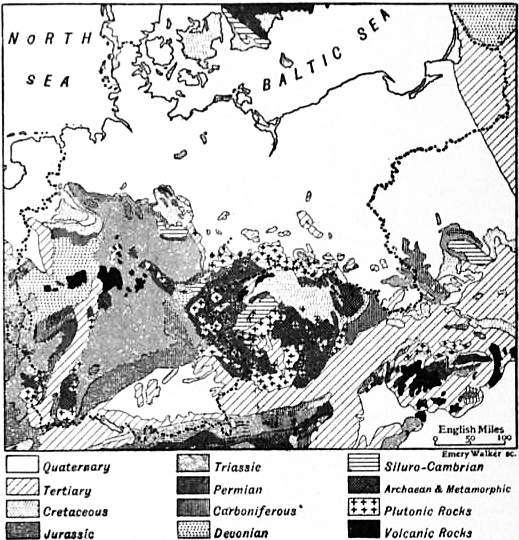
Geology.—Germany consists of a floor of folded Palaeozoic rocks upon which rest unconformably the comparatively little disturbed beds of the Mesozoic system, while in the North German plain a covering of modern deposits conceals the whole of the older strata from view, excepting some scattered and isolated outcrops of Cretaceous and Tertiary beds. The rocks which compose the ancient floor are thrown into folds which run approximately from W.S.W. to E.N.E. They are exposed on the one hand in the neighbourhood of the Rhine and on the other hand in the Bohemian massif. With the latter must be included the Frankenwald, the Thüringerwald, and even the Harz. The oldest rocks, belonging to the Archaean system, occur in the south, forming the Vosges and the Black Forest in the west, and the greater part of the Bohemian massif, including the Erzgebirge, in the east. They consist chiefly of gneiss and schist, with granite and other eruptive rocks. Farther north, in the Hunsrück, the Taunus, the Eifel and Westerwald, the Harz and the Frankenwald, the ancient floor is composed mainly of Devonian beds. Other Palaeozoic systems are, however, included in the folds. The Cambrian, for example, is exposed at Leimitz near Hof in the Frankenwald, and the important coal-field of the Saar lies on the southern side of the Hunsrück, while Ordovician and Silurian beds have been found in several localities. Along the northern border of the folded belt lies the coal basin of the Ruhr in Westphalia, which is the continuation of the Belgian coal-field, and bears much the same relation to the Rhenish Devonian area that the coal basin of Liége bears to the Ardennes. Carboniferous and Devonian beds are also found south-east of the Bohemian massif, where lies the extensive coal-field of Silesia. The Permian, as in England, is not involved in the folds which have affected the older beds, and in general lies unconformably upon them. It occurs chiefly around the masses of ancient rock, and one of the largest areas is that of the Saar.
Between the old rocks of the Rhine on the west and the ancient massif of Bohemia on the east a vast area of Triassic beds extends from Hanover to Basel and from Metz to Bayreuth. Over the greater part of this region the Triassic beds are free from folding and are nearly horizontal, but faulting is by no means absent, especially along the margins of the Bohemian and Rhenish hills. The Triassic beds must indeed have covered a large part of these old rock masses, but they have been preserved only where they were faulted down to a lower level. Along the southern margin of the Triassic area there is a long band of Jurassic beds dipping towards the Danube; and at its eastern extremity this band is continuous with a synclinal of Jurassic beds, running parallel to the western border of the Bohemian massif, but separated from it by a narrow strip of Triassic beds. Towards the north, in Hanover and Westphalia, the Triassic beds are followed by Jurassic and Cretaceous deposits, the latter being here the more important. As in the south of England, the lower beds of the Cretaceous are of estuarine origin and the Upper Cretaceous overlaps the Lower, lying in the valley of the Ruhr directly upon the Palaeozoic rocks. In Saxony also the upper Cretaceous beds rest directly upon the Palaeozoic or Archaean rocks. Still more to the east, in the province of Silesia, both Jurassic and Cretaceous beds are again met with, but they are to a large extent concealed by the recent accumulations of the great plain. The Eocene system is unknown in Germany except in the foothills of the Alps; but the Oligocene and Miocene are widely spread, especially in the great plain and in the depression of the Danube. The Oligocene is generally marine. Marine Miocene occurs in N.W. Germany and the Miocene of the Danube valley is also in part marine, but in central Germany it is of fluviatile or lacustrine origin. The lignites of Hesse, Cassel, &c., are interstratified with basaltic lava-flows which form the greater part of the Vogelsberg and other hills. The trachytes of the Siebengebirge are probably of slightly earlier date. The precise age of the volcanoes of the Eifel, many of which are in a very perfect state of preservation, is not clear, but they are certainly Tertiary or Post-tertiary. Leucite and nepheline lavas are here abundant. In the Siebengebirge the little crater of Roderberg, with its lavas and scoriae of leucite-basalt, is posterior to some of the Pleistocene river deposits.
A glance at a geological map of Germany will show that the greater part of Prussia and of German Poland is covered by Quaternary deposits. These are in part of glacial origin, and contain Scandinavian boulders; but fluviatile and aeolian deposits also occur. Quaternary beds also cover the floor of the broad depression through which the Rhine meanders from Basel to Mainz, and occupy a large part of the plain of the Danube. The depression of the Rhine is a trough lying between two faults or system of faults. The very much broader depression of the Danube is associated with the formation of the Alps, and was flooded by the sea during a part of the Miocene period.
(P. La.)
Climate.—The climate of Germany is to be regarded as intermediate between the oceanic and continental climates of western and eastern Europe respectively. It has nothing in common with the Mediterranean climate of southern Europe, Germany being separated from that region by the lofty barrier of the Alps. Although there are very considerable differences in the range of temperature and the amount of rainfall throughout Germany, these are not so great as they would be were it not that the elevated plateaus and mountain chains are in the south, while the north is occupied by low-lying plains. In the west no chain of hills intercepts the warmer and moister winds which blow from the Atlantic, and these accordingly influence at times even the eastern regions of Germany. The mean annual temperature of south-western Germany, or the Rhine and Danube basins, is about 52° to 54° F., that of central Germany 48° to 50°, and that of the northern plain 46° to 48°. In Pomerania and West Prussia it is only 44° to 45°, and in East Prussia 42° to 44°. The mean January temperature varies between 22° and 34° (in Masuren and Cologne respectively); the mean July temperature, between 61° in north Schleswig and 68° at Cologne. The extremes of cold and heat are, as recorded in the ten years 1895-1905, 7° in Königsberg and 93° in Heidelberg (the hottest place in Germany). The difference in the mean annual temperature between the south-west and north-west of Germany amounts to about 3°. The contrasts of heat and cold are furnished by the valley of the Rhine above Mainz, which has the greatest mean heat, the mildest winter and the highest summer temperature, and the lake plateau of East Prussia, where Arys on the Spirdingsee has a like winter temperature to the Brocken at 3200 ft. The Baltic has the lowest spring temperature, and the autumn there is also not characterized by an appreciably higher degree of warmth. In central Germany the high plateaus of the Erz and Fichtelgebirge are the coldest regions. In south Germany the upper Bavarian plain experiences an inclement winter and a cold summer. In Alsace-Lorraine the Vosges and the plateau of Lorraine are also remarkable for low temperatures. The warmest districts of the German empire are the northern parts of the Rhine plain, from Karlsruhe downwards, especially the Rheintal; these are scarcely 300 ft. above the sea-level, and are protected by mountainous tracts of land. The same holds true of the valleys of the Neckar, Main and Mosel. Hence the vine is everywhere cultivated in these districts. The mean summer temperature there is 66° and upwards, while the average temperature of January does not descend to the freezing point (32°). The climate of north-western Germany (west of the Elbe) shows a predominating oceanic character, the summers not being too hot (mean summer temperature 60° to 62°), and snow in winter remaining but a short time on the ground. West of the Weser the average temperature of January exceeds 32°; to the east it sinks to 30°, and therefore the Elbe is generally covered with ice for some months of the year, as are also its tributaries. The farther one proceeds to the east the greater are the contrasts of summer and winter. While the average summer warmth of Germany is 60° to 62°, the January temperature falls as low as 26° to 28° in West Prussia, Posen and Silesia, and 22° to 26° in East Prussia and upper Silesia. The navigation of the rivers is regularly interrupted by frost. Similarly the upper basin of the Danube, or the Bavarian plain, has a rather inclement climate in winter, the average for January being 25° to 26°.
As regards rainfall, Germany belongs to those regions where precipitation takes place at all seasons, but chiefly in the form of summer rains. In respect to the quantity of rain the empire takes a middle position between the humidity of north-western Europe and the aridity of the east. There are considerable differences between particular places. The rainfall is greatest in the Bavarian tableland and the hilly regions of western Germany. For the Eifel, Sauerland, Harz, Thuringian Forest, Rhön, Vogelsberg, Spessart, the Black Forest, the Vosges, &c., the annual average may be stated at 34 in. or more, while in the lower terraces of south-western Germany, as in the Erzgebirge and the Sudetic range, it is estimated at 30 to 32 in. only. The same average obtains also on the humid north-west coast of Germany as far as Bremen and Hamburg. In the remaining parts of western Germany, on the shores of farther Pomerania, and in East Prussia, it amounts to upwards of 24 in. In western Germany there is a district famous for the scarcity of rain and for producing the best kind of wine: in the valley of the Rhine below Strassburg, in the Palatinate, and also in the valley of the Main, no more than from 16 to 20 in. fall. Mecklenburg, Brandenburg and Lusatia, Saxony and the plateau of Thuringia, West Prussia, Posen and lower Silesia are also to be classed among the more arid regions of Germany, the annual rainfall being 16 to 20 in. Thunderstorms are most frequent in July, and vary between fifteen and twenty-five in the central districts, descending in the eastern provinces of Prussia to ten annually.
Flora.—The flora of Germany comprises 3413 species of phanerogamic and 4306 cryptogamic plants. The country forms a section of the central European zone, and its flora is largely under the influence of the Baltic and Alpine elements, which to a great degree here coalesce. All plants peculiar to the temperate zone abound. Wheat, rye, barley and oats are cultivated everywhere, but spelt only in the south and buckwheat in the north and north-west. Maize only ripens in the south. Potatoes grow in every part of the country, those of the sandy plains in the north being of excellent quality. All the commoner sorts of fruit—apples, pears, cherries, &c.—grow everywhere, but the more delicate kinds, such as figs, apricots and peaches, are confined to the warmer districts. The vine flourishes as far as the 51° N., but only yields good wine in the districts of the Rhine and Danube. Flax is grown in the north, and hemp more particularly in the central districts. Rape can be produced everywhere when the soil permits. Tobacco is cultivated on the upper Rhine and in the valley of the Oder. The northern plain, especially in the province of Saxony, produces beet (for sugar), and hops are largely grown in Bavaria, Württemberg, Alsace, Baden and the Prussian province of Posen.
Speaking generally, northern Germany is not nearly so well wooded as central and southern Germany, where indeed most of the lower mountains are covered with timber, as is indicated by the frequent use of the termination Forests. wald affixed to the names of the mountain ranges (as Schwarzwald, Thüringerwald, &c.). The “Seenplatten” are less wooded than the hill country, but the eastern portion of the northern lowlands is well provided with timber. A narrow strip along the shores of the Baltic is covered with oaks and beeches; farther inland, and especially east of the Elbe, coniferous trees are the most prevalent, particularly the Scotch fir; birches are also abundant. The mountain forests consist chiefly of firs, pines and larches, but contain also silver firs, beeches and oaks. Chestnuts and walnuts appear on the terraces of the Rhine valley and in Swabia and Franconia. The whole north-west of Germany is destitute of wood, but to compensate for this the people have ample supplies of fuel in the extensive stretches of turf.
Fauna.—The number of wild animals in Germany is not very great. Foxes, martens, weasels, badgers and otters are to be found everywhere; bears are found in the Alps, wolves are rare, but they find their way sometimes from French territory to the western provinces, or from Poland to Prussia and Posen. Among the rodents the hamster and the field-mouse are a scourge to agriculture. Of game there are the roe, stag, boar and hare; the fallow deer and the wild rabbit are less common. The elk is to be found in the forests of East Prussia. The feathered tribes are everywhere abundant in the fields, woods and marshes. Wild geese and ducks, grouse, partridges, snipe, woodcock, quails, widgeons and teal are plentiful all over the country, and in recent years preserves have been largely stocked with pheasants. The length of time that birds of passage remain in Germany differs considerably with the different species. The stork is seen for about 170 days, the house-swallow 160, the snow-goose 260, the snipe 220. In northern Germany these birds arrive from twenty to thirty days later than in the south.
The waters of Germany abound with fish; but the genera and species are few. The carp and salmon tribes are the most abundant; after them rank the pike, the eel, the shad, the roach, the perch and the lamprey. The Oder and some of the tributaries of the Elbe abound in crayfish, and in the stagnant lakes of East Prussia leeches are bred. In addition to frogs, Germany has few varieties of Amphibia. Of serpents there are only two poisonous kinds, the common viper and the adder (Kreuzotter).
Population.—Until comparatively recent times no estimate of the population of Germany was precise enough to be of any value. At the beginning of the 19th century the country was divided into some hundred states, but there was no central agency for instituting an exact census on a uniform plan. The formation of the German Confederation in 1815 effected but little change in this respect, and it was left to the different states to arrange in what manner the census should be taken. On the foundation, however, of the German customs union, or Zollverein, between certain German states, the necessity for accurate statistics became apparent and care was taken to compile trustworthy tables. Researches show the population of the German empire, as at present constituted, to have been: (1816) 24,833,396; (1855) 36,113,644; and (1871) 41,058,792. The following table shows the population and area of each of the states included in the empire for the years 1871, 1875, 1900 and 1905:—
Area and Population of the German States.
States of the Empire. Area English Sq. m. Population. Density per Sq. m.
1871. 1875. 1900. 1905.
Kingdoms—
Prussia 134,616 24,691,433 25,742,404 34,472,509 37,293,324 277.3
Bavaria 29,292 4,863,450 5,022,390 6,176,057 6,524,372 222.7
Saxony 5,789 2,556,244 2,760,586 4,202,216 4,508,601 778.8
Württemberg 7,534 1,818,539 1,881,505 2,169,480 2,302,179 305.5
Grand-Duchies—
Baden 5,823 1,461,562 1,507,179 1,867,944 2,010,728 345.3
Hesse 2,966 852,894 884,218 1,119,893 1,209,175 407.6
Mecklenburg-Schwerin 5,068 557,897 553,785 607,770 625,045 123.3
Saxe-Weimar 1,397 286,183 292,933 362,873 388,095 277.8
Mecklenburg-Strelitz 1,131 96,982 95,673 102,602 103,451 91.5
Oldenburg 2,482 314,459 319,314 399,180 438,856 176.8
Duchies—
Brunswick 1,418 311,764 327,493 464,333 485,958 342.5
Saxe-Meiningen 953 187,957 194,494 250,731 268,916 282.2
Saxe-Altenburg 511 142,122 145,844 194,914 206,508 404.1
Saxe-Coburg-Gotha 764 174,339 182,599 229,550 242,432 317.3
Anhalt 888 203,437 213,565 316,085 328,029 369.4
Principalities—
Schwartzburg-Sondershausen 333 75,523 76,676 80,898 85,152 255.7
Schwartzburg-Rudolstadt 363 67,191 67,480 93,059 96,835 266.7
Waldeck 433 56,224 54,743 57,918 59,127 136.5
Reuss-Greiz 122 45,094 46,985 68,396 70,603 578.7
Reuss-Schleiz 319 89,032 92,375 139,210 144,584 453.2
Schaumburg-Lippe 131 32,059 33,133 43,132 44,992 343.4
Lippe 469 111,135 112,452 138,952 145,577 310.4
Free Towns—
Lübeck 115 52,158 56,912 96,775 105,857 920.5
Bremen 99 122,402 142,200 224,882 263,440 2661.0
Hamburg 160 338,974 388,618 768,349 874,878 5467.9
Imperial Territory—
Alsace-Lorraine 5,604 1,549,738 1,531,804 1,719,470 1,814,564 323.8
German Empire 208,780 41,058,792 42,727,360 56,367,178 60,641,278 290.4
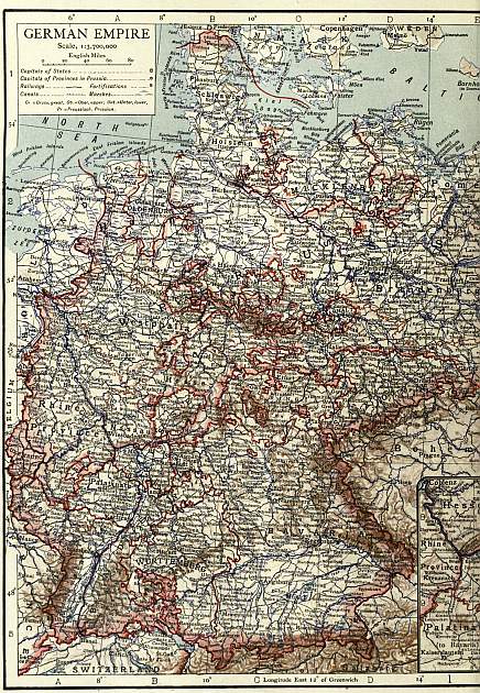
(Click to enlarge left side.)
(Click to enlarge right side.)
The population of the empire has thus increased, since 1871, by 19,582,486 or 47.6%. The increase of population during 1895-1900 was greatest in Hamburg, Bremen, Lübeck, Saxony, Prussia and Baden, and least in Mecklenburg-Strelitz and Waldeck. Of the total population in 1900, 54.3% was urban (i.e. living in towns of 2000 inhabitants and above), leaving 45.7% to be classified as rural. On the 1st of December 1905, of the total population 29,884,681 were males and 30,756,597 females; and it is noticeable that the male population shows of late years a larger relative increase than the female, the male population having in five years increased by 2,147,434 and the female by only 2,126,666. The greater increase in the male population is attributable to diminished emigration and to the large increase in immigrants, who are mostly males. In 1905, 485,906 marriages were contracted in Germany, being at the rate of 8.0 per thousand inhabitants. In the same year the total number of births was 2,048,453. Of these, 61,300 were stillborn and 174,494 illegitimate, being at the rate, respectively, of 3% and 8.5% of the total. Illegitimacy is highest in Bavaria (about 15%), Berlin (14%), and over 12% in Saxony, Mecklenburg-Schwerin and Saxe-Meiningen. It is lowest in the Rhine Province and Westphalia (3.9 and 2.6 respectively). Divorce is steadily on the increase, being in 1904, 11.1 per 10,000 marriages, as against 8.1, 8.1, 9.3 and 10.1 for the four preceding years. The average deaths for the years 1901-1905 amounted to 1,227,903; the rate was thus 20.2 per thousand inhabitants, but the death-rate has materially decreased, the total number of deaths in 1907 standing at 1,178,349; the births for the same year were 2,060,974. In connexion with suicides, it is interesting to observe that the highest rates prevail in some of the smaller and more prosperous states of the empire—for example, in Saxe-Weimar, Saxe-Coburg-Gotha and Saxe-Altenburg (on a three years’ average of figures), while the Roman Catholic country Bavaria, and the impoverished Prussian province of Posen show the most favourable statistics. For Prussia the rate is 20, and for Saxony it is as high as 31 per 100,000 inhabitants. The large cities, notably Berlin, Hamburg, Breslau and Dresden, show, however, relatively the largest proportion.
In 1900 the German-speaking population of the empire amounted to 51,883,131. Of the inhabitants speaking other languages there were: Polish, 3,086,489; French (mostly in Lorraine), 211,679; Masurian, 142,049; Danish, 141,061; Lithuanian, 106,305; Cassubian, 100,213; Wendish, 93,032; Dutch, 80,361; Italian, 65,961; Moravian, 64,382; Czech, 43,016; Frisian, 20,677; English, 20,217; Walloon, 11,841. In 1905 there were resident within the empire 1,028,560 subjects of foreign states, as compared with 778,698 in 1900. Of these 17,293 were subjects of Great Britain and Ireland, 17,184 of the United States of America and 20,584 of France. The bulk of the other foreigners residing in the country belonged to countries lying contiguous, such as Austria, which claimed nearly the half, Russia and Italy.
Languages.—The German-speaking nations in their various branches and dialects, if we include the Dutch and the Walloons, extend in a compact mass along the shores of the Baltic and of the North Sea, from Memel in the east to a point between Gravelines and Calais near the Straits of Dover. On this northern line the Germans come in contact with the Danes who inhabit the northern parts of Schleswig within the limits of the German empire. A line from Flensburg south-westward to Joldelund and thence northwestward to Hoyer will nearly give the boundary between the two idioms.2 The German-French frontier traverses Belgium from west to east, touching the towns of St Omer, Courtrai and Maastricht. Near Eupen, south of Aix-la-Chapelle, it turns southward, and near Arlon south-east as far as the crest of the Vosges mountains, which it follows up to Belfort, traversing there the watershed of the Rhine and the Doubs. In the Swiss territory the line of demarcation passes through Bienne, Fribourg, Saanen, Leuk and Monte Rosa. In the south the Germans come into contact with Rhaeto-Romans and Italians, the former inhabiting the valley of the Vorder-Rhein and the Engadine, while the latter have settled on the southern slopes of the Alps, and are continually advancing up the valley of the Adige. Carinthia and Styria are inhabited by German people, except the valley of the Drave towards Klagenfurt. Their eastern neighbours there are first the Magyars, then the northern Slavs and the Poles. The whole eastern frontier is very much broken, and cannot be described in a few words. Besides detached German colonies in Hungary proper, there is a considerable and compact German (Saxon) population in Transylvania. The river March is the frontier north of the Danube from Pressburg as far as Brünn, to the north of which the German regions begin near Olmütz, the interior of Bohemia and Moravia being occupied by Czechs and Moravians. In these countries the Slav language has been steadily superseding the German. In the Prussian provinces of Silesia and Posen the eastern parts are mixed territories, the German language progressing very slowly among the Poles. In Bromberg and Thorn, in the valley of the Vistula, German is prevalent. In West Prussia some parts of the interior, and in East Prussia a small region along the Russian frontier, are occupied by Poles (Cassubians in West Prussia, Masurians in East Prussia). The total number of German-speaking people, within the boundaries wherein they constitute the compact mass of the population, may be estimated, if the Dutch and Walloons be included, at 65 millions.
The geographical limits of the German language thus do not quite coincide with the German frontiers. The empire contains about 31⁄3 millions of persons who do not make use of German in everyday life, not counting the resident foreigners.
Apart from the foreigners above mentioned, German subjects speaking a tongue other than German are found only in Prussia, Saxony and Alsace-Lorraine. The following table shows roughly the distribution of German-speaking people in the world outside the German empire:—
Austria-Hungary 12,000,000 Other European Countries 2,300,000
Netherlands (Dutch) 5,200,000 America 13,000,000
Belgium (Walloon) 4,000,000 Asia 100,000
Luxemburg 200,000 Africa 600,000
Switzerland 2,300,000 Australia 150,000
France 500,000
According to the census of the 1st of December 1900 there were 51,634,757 persons speaking commonly one language and 248,374 speaking two languages. In the kingdom of Saxony, according to the census of 1900, there were 48,000 Wends, mostly in Lusatia. With respect to Alsace-Lorraine, detailed estimates (but no census) gave the number of French in the territory of Lorraine at about 170,000, and in that of Alsace at about 46,000.
The Poles have increased very much, owing to a greater surplus of births than in the case of the German people in the eastern provinces of Prussia, to immigration from Russia, and to the Polonization of many Germans through clerical and other influences (see History). The Poles are in the majority in upper Silesia (Government district of Oppeln; 55%) and the province of Posen (60%). They are numerous in West Prussia (34%) and East Prussia (14%).
The Wends are decreasing in number, as are also the Lithuanians on the eastern border of East Prussia, Czechs are only found in Silesia on the confines of Bohemia.
Russians flocked to Germany in thousands after the Russo-Japanese War and the insurrections in Russia, and the figures given for 1900 had been doubled in 1907. Males preponderate among the various nationalities, with the exception of the British, the larger proportion of whom are females either in domestic service or engaged in tuition.
Chief Towns.—According to the results of the census of the 1st of December 1905 there were within the empire 41 towns with populations exceeding 100,000, viz.:—
State. Population.
Berlin Prussia 2,040,148
Hamburg Hamburg 802,793
Munich Bavaria 538,393
Dresden Saxony 516,996
Leipzig ” 502,570
Breslau Prussia 470,751
Cologne ” 428,503
Frankfort-on-Main ” 334,951
Nuremberg Bavaria 294,344
Düsseldorf Prussia 253,099
Hanover ” 250,032
Stuttgart Württemberg 249,443
Chemnitz Saxony 244,405
Magdeburg Prussia 240,661
Charlottenburg ” 239,512
Essen ” 231,396
Stettin ” 224,078
Königsberg ” 219,862
Bremen Bremen 214,953
Duisburg Prussia 192,227
Dortmund ” 175,575
Halle ” 169,899
Altona ” 168,301
Strassburg Alsace-Lorraine 167,342
Kiel Prussia 163,710
Elberfeld ” 162,682
Mannheim Baden 162,607
Danzig Prussia 159,685
Barmen ” 156,148
Rixdorf ” 153,650
Gelsenkirchen ” 147,037
Aix-la-Chapelle ” 143,906
Schöneberg ” 140,992
Brunswick Brunswick 136,423
Posen Prussia 137,067
Cassel ” 120,446
Bochum ” 118,455
Karlsruhe Baden 111,200
Crefeld Prussia 110,347
Plauen Saxony 105,182
Wiesbaden Prussia 100,953
Density of Population.—In respect of density of population, Germany with (1900) 269.9 and (1905) 290.4 inhabitants to the square mile is exceeded in Europe only by Belgium, Holland and England. Apart from the free cities, Hamburg, Bremen and Lübeck, the kingdom of Saxony is the most, and Mecklenburg-Strelitz the least, closely peopled state of the empire. The most thinly populated districts are found, not as might be expected in the mountain regions, but in some parts of the plains. Leaving out of account the small centres, Germany may be roughly divided into two thinly and two densely populated parts. In the former division has to be classed all the North German plain. There it is only in the valleys of the larger navigable rivers and on the southern border of the plain that the density exceeds 200 inhabitants per square mile. In some places, indeed, it is far greater, e.g. at the mouths of the Elbe and the Weser, in East Holstein, in the delta of the Memel and the environs of Hamburg. This region is bordered on the south by a densely peopled district, the northern boundary of which may be defined by a line from Coburg via Cassel to Münster, for in this part there are not only very fertile districts, such as the Goldene Aue in Thuringia, but also centres of industry. The population is thickest in upper Silesia around Beuthen (coal-fields), around Ratibor, Neisse and Waldenburg (coal-fields), around Zittau (kingdom of Saxony), in the Elbe valley around Dresden, in the districts of Zwickau and Leipzig as far as the Saale, on the northern slopes of the Harz and around Bielefeld in Westphalia. In all these the density exceeds 400 inhabitants to the square mile, and in the case of Saxony rises to 750. The third division of Germany comprises the basin of the Danube and Franconia, where around Nuremberg, Bamberg and Würzburg the population is thickly clustered. The fourth division embraces the valleys of the upper Rhine and Neckar and the district of Düsseldorf on the lower Rhine. In this last the proportion exceeds 1200 inhabitants to the square mile.
Emigration.—There have been great oscillations in the actual emigration by sea. It first exceeded 100,000 soon after the Franco-German War (1872, 126,000), and this occurred again in the years 1880 to 1892. Germany lost during these thirteen years more than 1,700,000 inhabitants by emigration. The total number of those who sailed for the United States from 1820 to 1900 may be estimated at more than 4,500,000. The number of German emigrants to Brazil between 1870 and 1900 was about 52,000. The greater number of the more recent emigrants was from the agricultural provinces of northern Germany—West Prussia, Posen, Pomerania, Mecklenburg, Schleswig-Holstein and Hanover, and sometimes the emigration reached 1% of the total population of these provinces. In subsequent years the emigration of native Germans greatly decreased and, in 1905, amounted only to 28,075. But to this number must be added 284,787 foreigners who in that year were shipped from German ports (notably Hamburg and Bremen) to distant parts. Of the above given numbers of purely German emigrants 26,007 sailed for the United States of America; 243 to Canada; 333 to Brazil; 674 to the Argentine Republic; 7 to other parts of America; 57 to Africa; and 84 to Australia.
Agriculture.—Despite the enormous development of industries and commerce, agriculture and cattle-rearing still represent in Germany a considerable portion of its economic wealth. Almost two-thirds of the soil is occupied by arable land, pastures and meadows, and of the whole area, in 1900, 91% was classed as productive. Of the total area 47.67% was occupied by land under tillage, 0.89% by gardens, 11.02% by meadow-land, 5.01% by pastures, and 0.25% by vineyards. The largest estates are found in the Prussian provinces of Pomerania, Posen and Saxony, and in East and West Prussia, while in the Prussian Rhine province, in Baden and Württemberg small farms are the rule.
The same kinds of cereal crops are cultivated in all parts of the empire, but in the south and west wheat is predominant, and in the north and east rye, oats and barley. To these in some districts are added spelt, buckwheat, millet, rice-wheat, lesser spelt and maize. In general the soil is remarkably well cultivated. The three years’ rotation formerly in use, where autumn and spring-sown grain and fallow succeeded each other, has now been abandoned, except in some districts, where the system has been modified and improved. In south Germany the so-called Fruchtwechsel is practised, the fields being sown with grain crops every second year, and with pease or beans, grasses, potatoes, turnips, &c., in the intermediate years. In north Germany the mixed Koppelwirthschaft is the rule, by which system, after several years of grain crops, the ground is for two or three seasons in pasture.
Taking the average of the six years 1900-1905, the crop of wheat amounted to 3,550,033 tons (metric), rye to 9,296,616 tons, barley to 3,102,883 tons, and oats to 7,160,883 tons. But, in spite of this considerable yield in cereals, Germany cannot cover her home consumption, and imported on the average of the six years 1900-1905 about 4½ million tons of cereals to supply the deficiency. The potato is largely cultivated, not merely for food, but for distillation into spirits. This manufacture is prosecuted especially in eastern Germany. The number of distilleries throughout the German empire was, in 1905-1906, 68,405. The common beet (Beta vulgaris) is largely grown in some districts for the production of sugar, which has greatly increased of recent years. There are two centres of the beet sugar production: Magdeburg for the districts Prussian Saxony, Hanover, Brunswick, Anhalt and Thuringia, and Frankfort-on-Oder at the centre of the group Silesia, Brandenburg and Pomerania. Flax and hemp are cultivated, though not so much as formerly, for manufacture into linen and canvas, and also rape seed for the production of oil. The home supply of the former no longer suffices for the native demand. The cultivation of hops is in a very thriving condition in the southern states of Germany. The soil occupied by hops was estimated in 1905 at 98,000 acres—a larger area than in Great Britain, which had in the same year about 48,000 acres. The total production of hops was 29,000 tons in 1905, and of this over 25,000 were grown in Bavaria, Württemberg, Baden and Alsace-Lorraine. Almost the whole yield in hops is consumed in the country by the great breweries.
Tobacco forms a most productive and profitable object of culture in many districts. The total extent under this crop in 1905 was about 35,000 acres, of which 45% was in Baden, 12% in Bavaria, 30% in Prussia, and the rest in Alsace and Hesse-Darmstadt. In the north the plant is cultivated principally in Pomerania, Brandenburg and East and West Prussia. Of late years the production has somewhat diminished, owing to the extensive tobacco manufacturing industries of Bremen and Hamburg, which import almost exclusively foreign leaves.
Ulm, Nuremberg, Quedlinburg, Erfurt, Strassburg and Guben are famed for their vegetables and garden seeds. Berlin is noted for its flower nurseries, the Rhine valley, Württemberg and the Elbe valley below Dresden for fruit, and Frankfort-on-main for cider.
The culture of the vine is almost confined to southern and western Germany, and especially to the Rhine district. The northern limits of its growth extend from Bonn in a north-easterly direction through Cassel to the southern foot of the Vine. Harz, crossing 52° N. on the Elbe, running then east some miles to the north of that parallel, and finally turning sharply towards the south-west on the Warthe. In the valley of the Saale and Elbe (near Dresden), and in lower Silesia (between Guben and Grünberg), the number of vineyards is small, and the wines of inferior quality; but along the Rhine from Basel to Coblenz, in Alsace, Baden, the Palatinate and Hesse, and above all in the province of Nassau, the lower slopes of the hills are literally covered with vines. Here are produced the celebrated Rüdesheimer, Hochheimer and Johannisberger. The vines of the lower Main, particularly those of Würzburg, are the best kinds; those of the upper Main and the valley of the Neckar are rather inferior. The Moselle wines are lighter and more acid than those of the Rhine. The total amount produced in Germany is estimated at 1000 million gallons, of a value of £4,000,000; Alsace-Lorraine turning out 400 millions; Baden, 175; Bavaria, Württemberg and Hesse together, 300; while the remainder, which though small in quantity is in quality the best, is produced by Prussia.
The cultivation of grazing lands in Germany has been greatly improved in recent times and is in a highly prosperous condition. The provinces of Schleswig-Holstein, Pomerania, Hanover (especially the marsh-lands near the sea) and the grand-duchy Live stock. of Mecklenburg-Schwerin are particularly remarkable in this respect. The best meadow-lands of Bavaria are in the province of Franconia and in the outer range of the Alps, and those of Saxony in the Erzgebirge. Württemberg, Hesse and Thuringia also yield cattle of excellent quality. These large cattle-rearing centres not only supply the home markets but export live stock in considerable quantities to England and France. Butter is also largely exported to England from the North Sea districts and from Schleswig-Holstein and Mecklenburg. The breeding of horses has attained a great perfection. The main centre is in East and West Prussia, then follow the marsh districts on the Elbe and Weser, some parts of Westphalia, Oldenburg, Lippe, Saxony and upper Silesia, lower Bavaria and Alsace-Lorraine. Of the stud farms Trakehnen in East Prussia and Graditz in the Prussian province of Saxony enjoy a European reputation. The aggregate number of sheep has shown a considerable falling off, and the rearing of them is mostly carried on only on large estates, the number showing only 9,692,501 in 1900, and 7,907,200 in 1904, as against 28,000,000 in 1860. As a rule, sheep-farming is resorted to where the soil is of inferior quality and unsuitable for tillage and the breeding of cattle. Far more attention is accordingly given to sheep-farming in northern and north-eastern Germany than in Schleswig-Holstein, Westphalia, the Rhineland and south Germany. The native demand for wool is not covered by the home production, and in this article the export from the United Kingdom to Germany is steadily rising, having amounted in 1905 to a value of £1,691,035, as against £742,632 in 1900. The largest stock of pigs is in central Germany and Saxony, in Westphalia, on the lower Rhine, in Lorraine and Hesse. Central Germany (especially Gotha and Brunswick) exports sausages and hams largely, as well as Westphalia, but here again considerable importation takes place from other countries. Goats are found everywhere, but especially in the hilly districts. Poultry farming is a considerable industry, the geese of Pomerania and the fowls of Thuringia and Lorraine being in especial favour. Bee-keeping is of considerable importance, particularly in north Germany and Silesia.
On the whole, despite the prosperous condition of the German live-stock farming, the consumption of meat exceeds the amount rendered available by home production, and prices can only be kept down by a steady increase in the imports from abroad.
Fisheries.—The German fisheries, long of little importance, have been carefully fostered within recent years. The deep-sea fishing in the North Sea, thanks to the exertions of the German fishing league (Deutscher Fischereiverein) and to government support, is extremely active. Trawlers are extensively employed, and steamers bring the catches directly to the large fish markets at Geestemünde and Altona, whence facilities are afforded by the railways for the rapid transport of fish to Berlin and other centres. The fish mostly caught are cod, haddock and herrings, while Heligoland yields lobsters, and the islands of Föhr, Amrum and Sylt oysters of good quality. The German North Sea fishing fleet numbered in 1905 618 boats, with an aggregate crew of 5441 hands. Equally well developed are the Baltic fisheries, the chief ports engaged in which are Danzig, Eckernförde, Kolberg and Travemünde. The principal catch is haddock and herrings. The catch of the North Sea and Baltic fisheries in 1906 was valued at over £700,000, exclusive of herrings for salting. The fisheries do not, however, supply the demand for fish, and fresh, salt and dried fish is imported largely in excess of the home yield.
Mines and Minerals.—Germany abounds in minerals, and the extraordinary industrial development of the country since 1870 is largely due to its mineral wealth. Having left France much behind in this respect, it now rivals Great Britain and the United States.
Germany produces more silver than any other European state, and the quantity is annually increasing. It is extracted from the ores in the mines of Freiburg (Saxony), the Harz Mountains, upper Silesia, Merseburg, Aix-la-Chapelle, Wiesbaden and Arnsberg. Gold is found in the sand of the rivers Isar, Inn and Rhine, and also, to a limited extent, on the Harz. The quantity yielded in 1905 was, of silver, about 400 tons of a value of £1,600,000, and gold, about 4 tons, valued at about £548,000.
Lead is produced in considerable quantities in upper Silesia, the Harz Mountains, in the Prussian province of Nassau, in the Saxon Erzgebirge and in the Sauerland. The yield in 1905 amounted to about 153,000 tons; of which 20,000 tons were exported.
Copper is found principally in the Mansfeld district of the Prussian province of Saxony and near Arnsberg in the Sauerland, the ore yielding 31,713 tons in 1905, of which 5000 tons were exported.
About 90% of the zinc produced in Europe is yielded by Belgium and Germany. It is mostly found in upper Silesia, around Beuthen, and in the districts of Wiesbaden and Aix-la-Chapelle. In 1905 no less than 198,000 tons of block zinc were produced, of which 16,500 tons were exported.
Of other minerals (with the exceptions of coal, iron and salt treated below) nickel and antimony are found in the upper Harz; cobalt in the hilly districts of Hesse and the Saxon Erzgebirge; arsenic in the Riesengebirge; quicksilver in the Sauerland and in the spurs of the Saarbrücken coal hills; graphite in Bavaria; porcelain clay in Saxony and Silesia; amber along the whole Baltic coast; and lime and gypsum in almost all parts.
Coal-mining appears to have been first practised in the 14th century at Zwickau (Saxony) and on the Ruhr. There are six large coal-fields, occupying an area of about 3600 sq. m., of which the most important occupies the basin of the Ruhr, its Coal. extent being estimated at 2800 sq. m. Here there are more than 60 beds, of a total thickness of 150 to 200 ft. of coal; and the amount in the pits has been estimated at 45,000 millions of tons. Smaller fields are found near Osnabrück, Ibbenbüren and Minden, and a larger one near Aix-la-Chapelle. The Saar coal-field, within the area enclosed by the rivers Saar, Nahe and Blies (460 sq. m.), is of great importance. The thickness of 80 beds amounts to 250 ft., and the total mass of coal is estimated at 45,400 million tons. The greater part of the basin belongs to Prussia, the rest to Lorraine. A still larger field exists in the upper Silesian basin, on the borderland between Austria and Poland, containing about 50,000 million tons. Beuthen is the chief centre. The Silesian coal-fields have a second centre in Waldenburg, east of the Riesengebirge. The Saxon coal-fields stretch eastwards for some miles from Zwickau. Deposits of less consequence are found in upper Bavaria, upper Franconia, Baden, the Harz and elsewhere.
The following table shows the rapidly increasing development of the coal production. That of lignite is added, the provinces of Saxony and Brandenburg being rich in this product:—
Production of Coal and Lignite.
Year. Coal. Lignite.
Quantities. Value. Hands. Quantities. Value. Hands.
Mill. Tons. Mill. Mks. Mill. Tons. Mill. Mks.
1871 29.4 218.4 . . 8.5 26.2 . .
1881 48.7 252.3 180,000 12.8 38.1 25,600
1891 73.7 589.5 283,000 20.5 54.2 35,700
1899 101.6 789.6 379,000 34.2 78.4 44,700
1900 109.3 966.1 414,000 40.5 98.5 50,900
1905 121.2 1049.9 490,000 52.5 122.2 52,800
This production permits a considerable export of coal to the west and south of the empire, but the distance from the coal-fields to the German coast is such that the import of British coal cannot yet be dispensed with (1905, over 7,000,000 tons). Besides this, from 7,000,000 to 8,000,000 tons of lignite come annually from Bohemia. In north Germany peat is also of importance as a fuel; the area of the peat moors in Prussia is estimated at 8000 sq. m., of which 2000 are in the north of Hanover.
The iron-fields of Germany fall into three main groups: those of the lower Rhine and Westphalia, of which Dortmund and Düsseldorf are the centres; those of Lorraine and the Saar; and those of upper Silesia. The output of the ore has enormously increased of recent years, and the production of pig iron, as given for 1905, amounted to 10,875,000 tons of a value of £28,900,000.
Germany possesses abundant salt deposits. The actual production not only covers the home consumption, but also allows a yearly increasing exportation, especially to Russia, Austria and Scandinavia. The provinces of Saxony and Hanover, with Thuringia and Anhalt, produce half the whole amount. A large salt-work is found at Strzalkowo (Posen), and smaller ones near Dortmund, Lippstadt and Minden (Westphalia). In south Germany salt abounds most in Württemberg (Hall, Heilbronn, Rottweil); the principal Bavarian works are at the foot of the Alps near Freilassing and Rosenheim. Hesse and Baden, Lorraine and the upper Palatinate have also salt-works. The total yield of mined salt amounted in 1905 to 6,209,000 tons, including 1,165,000 tons of rock salt. The production has made great advance, having in 1850 been only 5 million cwts.
Manufactures.—In no other country of the world has the manufacturing industry made such rapid strides within recent years as in Germany. This extraordinary development of industrial energy embraces practically all classes of manufactured articles. In a general way the chief manufactures may be geographically distributed as follows. Prussia, Alsace-Lorraine, Bavaria and Saxony are the chief seats of the iron manufacture. Steel is produced in Rhenish Prussia. Saxony is predominant in the production of textiles, though Silesia and Westphalia manufacture linen. Cotton goods are largely produced in Baden, Bavaria, Alsace-Lorraine and Württemberg, woollens and worsteds in Saxony and the Rhine province, silk in Rhenish Prussia (Elberfeld), Alsace and Baden. Glass and porcelain are largely produced in Bavaria; lace in Saxony; tobacco in Bremen and Hamburg; chemicals in the Prussian province of Saxony; watches in Saxony (Glashütte) and Nuremberg; toys in Bavaria; gold and silver filagree in Berlin and Aschaffenburg; and beer in Bavaria and Prussia.
It is perhaps more in respect of its iron industry than of its other manufactures that Germany has attained a leading position in the markets of the world. Its chief centres are in Westphalia and the Rhine province (auf roter Erde), in upper Silesia, Iron industry. in Alsace-Lorraine and in Saxony. Of the total production of pig iron in 1905 amounting to over 10,000,000 tons, more than the half was produced in the Rhineland and Westphalia. Huge blast furnaces are in constant activity, and the output of rolled iron and steel is constantly increasing. In the latter the greatest advance has been made. The greater part of it is produced at or around Essen, where are the famous Krupp works, and Bochum. Many states have been for a considerable time supplied by Krupp with steel guns and battleship plates. The export of steel (railway) rails and bridges from this part is steadily on the increase.