VOLUME IX SLICE VIII Ethiopia to Evangelical Association (continued 7)
Reading edition
In various parts of Europe, more particularly in calcareous regions, such as the Jura, the Causses in the south-east of France, and the Karst in the north-west of the Balkan peninsula, there are numerous subterranean or partly subterranean rivers. Several of the more important rivers are of very irregular flow, and some are subject to really formidable floods. This is particularly the case with rivers a large part of whose basin is made up of crystalline or other impervious rocks with steep slopes, like those of the Loire in France and the Ebro in Spain. The Danube and its tributaries, the great rivers of Germany, above all eastern Germany, and those of Italy, are also notorious for their inundations. In southern Europe, where the summers are nearly rainless, most of the rivers disappear altogether in that season.
Name of Lake and Country. Height above Sea. Area. Greatest Depth. Mean Depth. Volume. Millions of Cub. Ft.
Ft. Sq. m. Ft. Ft.
Ladoga, Russia 15 7004 730 .. ..
Onega, Russia 115 3765 About 1200 .. ..
Vener, Sweden 145 2149 280 .. ..
Chudskoye or Peipus, Russia 100 135728 90 .. ..
Vetter, Sweden 290 733 415 .. ..
Saima, Russia 255 680 185 .. ..
Päjäne, Russia 255 608 .. .. ..
Enare, Russia 490 549 .. .. ..
Segozero, Russia 481 140 .. .. ..
Mälar, Sweden 1.6 449 170 .. ..
Byelo-Ozero, Russia 400 434 35 .. ..
Pielis, Russia 305 422 .. .. ..
Topozero, Russia .. 411 .. .. ..
Uleå, Russia 375 380 60 .. ..
Ilmen, Russia 107 358 .. .. ..
Vigozero, Russia .. 332 .. .. ..
Imandra, Russia .. 329 .. .. ..
Balaton, Hungary 350 266 13 .. ..
Geneva, France and Switzerland 1220 225 1015 500 3,140,000
Kovdozero, Russia .. 225 .. .. ..
Constance, Germany and Switzerland 1295 208 825 295 1,711,000
Hjelmar, Sweden 79 187 60 .. ..
Neagh, Ireland 48 153 113 .. ..
Kubinskoye, Russia .. 152 .. .. ..
Mjösen, Norway 395 152 1485 .. ..
Garda, Italy and Austria 215 143 1135 445 1,757,000
Torne-träsk, Sweden 1140 139 .. .. ..
Neusiedler-see, Hungary 370 137 13 .. ..
Scutari, Turkey 20 About 130 33 12½ 45,900
Siljan, Sweden .. 123 .. .. ..
Virzjärvi, Russia 115 107 24 .. ..
Seliger, Russia 825 100 105 .. ..
Stor Afvan, Sweden 1370 92 925 .. ..
Yalpukh, Russia .. 89 .. .. ..
Neuchâtel, Switzerland 1415 85 500 210 500,000
Ylikitkakärvi, Russia 680 85 30 .. ..
Maggiore, Italy and Switzerland 645 82 1220 575 1,316,000
Corrib, Ireland 30 71 152 .. ..
Como, Italy 655 56 1360 .. ..
For many European lakes, especially the smaller ones, estimates have been made of the mean depth and the volume. A list of all the European lakes for which the altitude, extent, and greatest depth could be ascertained, compiled by Dr K. Lakes and marshes. Peucker, is published in the Geog. Zeitschrift (1896), pp. 606-616, where estimates of the mean depth and the volume are also given where procurable. The table given above, comprising only the larger lakes, is mainly based on this list, where the original authorities are mentioned. The figures entered in the table not taken from this list are after Strelbitsky, the Géog. Universelle of V. de St Martin, or, in the case of Swedish lakes, from the official handbook of Sweden.29
The Alpine lakes break up into a southern and northern subdivision—the former consisting of the Lago Maggiore, and the lakes of Lugano and Como, Lago d’Iseo, and Lago di Garda, all connected by affluents with the system of the Po; and the latter the Lake of Geneva threaded by the Rhone, Lakes Constance, Zürich, Neuchâtel, Biel and other Swiss lakes belonging to the basin of the Rhine, and a few of minor importance belonging to the Danube. The north Russian lakes, Ladoga, Onega, &c., are mainly noticeable as the largest members of what in some respects is the most remarkable system of lakes in the continent—the Finno-Russian, which consists of an almost countless number of comparatively small irregular basins formed in the surface of a granitic plateau. In Finland proper they occupy no less than a twelfth of the total area.
A few of the number are very shallow. The Neusiedler See, for example (the Peiso Lacus of the Latins and Fertö-tava of the Hungarians), completely dried up in 1693, 1738 and 1864, and left its bed covered for the most part with a deposit of salt.30 Lakes Copais in Boeotia and Fucino Celano in Italy have been entirely turned into dry land. The progress of agriculture has greatly diminished the extent of marsh land in Europe. The Minsk marshes in Russia form the largest area of this character still left, and on these large encroachments are gradually being made. Extensive marshes in northern Italy have been completely drained. The partial draining of the Pomptine marshes in Italy made Pope Pius VII. famous in the 18th century, and further reclamation works are still in progress there and elsewhere in the same country.
(G. G. C.)
The geological history of Europe31 is, to a large extent, a history of the formation and destruction of successive mountain chains. Four times a great mountain range has been raised across the area which now is Europe. Three times the mountain Geology. range has given way; portions have sunk beneath the sea, and have been covered by more recent sediments, while other portions remained standing and now rise as isolated blocks above the later beds which surround them. The last of the mountain ranges still stands, and is known under the names of the Alps, the Carpathians, the Balkans, the Caucasus, &c., but the work of destruction has already begun, and gaps have been formed by the collapse of parts of the chain. The Carpathians were once continuous with the Alps, and the Caucasus was probably connected with the Balkans across the site of the Black Sea.
These mountain chains were not raised by direct uplift. They consist of crumpled and folded strata, and are, in fact, wrinkles in the earth’s outer crust, formed by lateral compression, like the puckers which appear in a tablecloth when we push it forward against a book or other heavy object lying upon it. How the lateral or tangential pressures originated is still matter of controversy, but the usually accepted explanation is as follows. The interior of the earth in cooling contracts more rapidly than the exterior, and, if no other change took place, the outer crust would be left as a hollow sphere without any internal support. But the materials of which it is composed are not strong enough to bear its enormous weight, and, like an arch which is too weak in its abutments, it collapses upon the interior core. Where the crust is rigid it fractures, as an ordinary arch would fracture; and some portions fall inward, while other parts may even be wedged a little outward. Where, on the other hand, the crust is made of softer rock, it crumples and folds, and a mountain chain is produced. Such a mountain chain, for want of a better term, is called a folded mountain chain. The folding is most intense where a flexible portion of the crust lies next to a more rigid part. Where the folding has occurred, the rocks which were once comparatively soft become hard and rigid, and the next series of wrinkles will usually be formed beyond the limits of the old one. This is what has happened in the European area.
The oldest mountain chain lay in the extreme north-west of Europe, and its relics are seen in the outer Hebrides, the Lofoten Islands and the north of Norway. The rocks of this ancient chain have since been converted into gneiss, and they were folded and denuded before the deposition of the oldest known fossiliferous sediments. The mountain system must therefore have been formed in Pre-Cambrian times, and it has been called by Marcel Bertrand the Huronian chain. It is probable that a great land-mass lay towards the north-west; but in the sea which certainly existed south-east of the chain, the Cambrian, Ordovician and Silurian beds were deposited. In Russia and South Sweden these beds still lie flat and undisturbed; but in Norway, Scotland, the Lake District, North Wales and the north of Ireland they were crushed against the north-western continent and were not only intensely folded but were pushed forward over the old rocks of the Huronian chain. Thus was formed the Caledonian mountain system of Ed. Suess, in which the folds run from south-west to north-east. It was raised at the close of the Silurian period.
Then followed, in northern Europe, a continental period. By the elevation of the Caledonian chain the northern land-mass had grown southward and now extended as far as the Bristol Channel. Upon it the Old Red Sandstone was laid down in inland seas or lakes, while farther south contemporaneous deposits were formed in the open sea.
During the earlier part of the Carboniferous period the sea spread over the southern shores of the northern continent; but later the whole area again became land and the Coal Measures of northern Europe were laid down. Towards the close of the Carboniferous period the third great mountain chain was formed. It lay to the south of the Caledonian chain, and its northern margin stretched from the south of Ireland through South Wales, the north of France and the south of Belgium, and was continued round the Harz and the ancient rocks of Bohemia, and possibly into the south of Russia. It is along this northern margin, where the folded beds have been thrust over the rocks which lay to the north, that the coalfields of Dover and of Belgium occur. The general direction of the folds is approximately from west to east; but the chain consisted of two arcs, the western of which is called by Suess the Armorican chain and the eastern the Variscian. The two arcs together, which were undoubtedly formed at the same period, have been named by Bertrand the Hercynian chain. Everywhere the chief folding seems to have occurred before the deposition of the highest beds of the Upper Carboniferous, which lie unconformably upon the folded older beds. The Hercynian chain appears to have been of considerable breadth, at least in western Europe, for the Palaeozoic rocks of Spain and Portugal are thrown into folds which have the same general direction and which were formed at approximately the same period. In eastern Europe the evidence is less complete, because the Hercynian folds are buried beneath more recent deposits and have in some cases been masked by the superposition of a later series of folds.
The formation of this Carboniferous range was followed in northern Europe by a second continental period somewhat similar to that of the Old Red Sandstone, but the continent extended still farther to the south. The Permian and Triassic deposits of England and Germany were laid down in inland seas or upon the surface of the land itself. But southern Europe was covered by the open sea, and here, accordingly, the contemporaneous deposits were marine.
The Jurassic and Cretaceous periods were free from any violent folding or mountain building, and the sea again spread over a large part of the northern continent. There were indeed several oscillations, but in general the greater part of southern and central Europe lay beneath the waters of the ocean. Some of the fragments of the Hercynian chain still rose as islands above the waves, and at certain periods there seems to have been a more or less complete barrier between the waters which covered northern Europe and those which lay over the Mediterranean region. Thus, while the estuarine deposits of the Upper Jurassic and Lower Cretaceous were laid down in England and Germany, the purely marine Tithonian formation, with its peculiar fauna, was deposited in the south; and while the Chalk was formed in northern Europe, the Hippurite limestone was laid down in the south.
The Tertiary period saw fundamental changes in the geography of Europe. The formation of the great mountain ranges of the south, the Alpine system of Suess, perhaps began at an earlier date, but it was in the Eocene and Miocene periods that the chief part of the elevation took place. Arms of the sea extended up the valley of the Rhone and around the northern margin of the Alps, and also spread over the plains of Hungary and of southern Russia. Towards the middle of the Miocene period some of these arms were completely cut off from the ocean and large deposits of salt were formed, as at Wieliczka. At a later period south-eastern Europe was covered by a series of extensive lagoons, and the waters of these lagoons gradually became brackish, and then fresh, before the area was finally converted into dry land. Great changes also took place in the Mediterranean region. The Black Sea, the Aegean, the Adriatic and the Tyrrhenian Sea were all formed at various times during the Tertiary period, and the depression of these areas seems to be closely connected with the elevation of the neighbouring mountain chains.
Exactly what was happening in northern Europe during these great changes in the south it is not easy to say. The basaltic flows of the north of Ireland, the western islands of Scotland, the Faeroe Islands and Iceland are mere fragments of former extensive plateaus. No sign of marine Tertiary deposits of earlier age than Pliocene has been found in this northern part of Europe, and on the other hand plant remains are abundant in the sands and clays interbedded with the basalts. It is probable, therefore, that in Eocene times a great land-mass lay to the north-west of Europe, over which the basalt lavas flowed, and that the formation of this part of the Atlantic and perhaps of the North Sea did not take place until the Miocene period.
At a later date the climate, for some reason which has not yet been fully explained, grew colder over the whole of Europe, and the northern part was covered by a great ice-sheet which extended southward nearly as far as lat. 50° N., and has left its marks over the whole of the northern part of the continent. With the final melting and disappearance of the ice-sheet, the topography of Europe assumed nearly its present form, and man came upon the scene. Minor changes, such as the separation of Great Britain from the continent, may have occurred at a later date; but since the Glacial period there have, apparently, been no fundamental modifications in the configuration of Europe.
The elevation of each of the great mountain systems already described was accompanied by extensive eruptions of volcanic rocks, and the sequence appears to have been similar in every case. The volcanoes of the Mediterranean are the last survivors of the great eruptions which accompanied the elevation of the Alpine mountain system.
(P. La.)
In western Europe by far the most prevalent wind is the S.W. or W.S.W. It represents 25% of the annual total; while the N. is only 6%, the N.E. 8, the E. 9, the S. 13, the W. 17 and the N.W. 11. Of the summer total it represents 22%, Winds. while the N. is 9, N.E. 8, E. 7, S.E. 7, W. 21 and N.W. 17. In south-eastern Europe, on the other hand, the prevailing winds are from the N. and E.—the E. having the preponderance in winter and autumn.32 Of local winds the most remarkable are the föhn, in the Alps, distinguished for its warmth and dryness; the Rotenturm wind of Transylvania, which has similar characteristics; the bora of the Upper Adriatic, so noticeable for its violence; the mistral of southern France; the etesian winds of the Mediterranean; and the sirocco, which proves so destructive to the southern vegetation. Though it is only at comparatively rare intervals that the winds attain the development of a hurricane, the destruction of life and property which they occasion, both by sea and land, is in the aggregate of no small moment. About six or seven storms from the west pass over the continent every winter, usually appearing later in the southern districts, such as Switzerland or the Adriatic, than in the northern districts, as Scotland and Denmark.
The great determining factors of the climate of Europe are these. The northern borders of the continent are within the Arctic Circle; the most southern points of the mainland are 13½° or more north of the Tropic of Cancer; to the east extends Climate. for about 3000 m. the continuous land surface of Asia; to the west lie the waters of the north Atlantic, which penetrate in great inland seas to the north and south of the great European peninsula; the prevailing winds in western Europe as already stated are more or less south-westerly; and the arrangement of the highlands is such as to allow of the penetration of winds with a westerly element in their direction far to the east. The first two of these factors are not distinguishing influences. They affect the climate of Europe in the same manner as they do that of any other land surface in the same latitudes.
The remaining factors, however, are of the highest importance. It is to them in fact that Europe owes in a very large measure those physical conditions which are the basis of its recognition as a separate continent. In estimating the value of those factors one must bear in mind, first, that the waters of the north Atlantic are exceptionally warm, especially on the European side of the ocean. The Gulf Stream carries a large body of warm water northwards to near the parallel of 40° N., and to the north of the Gulf Stream prevailing south-westerly winds, especially during the winter months, drift onwards to the western and northern shores of Europe, even as far east as Spitsbergen, large bodies of water of an exceptionally high temperature. Secondly, one must bear in mind that these relatively high temperatures over the ocean promote evaporation and thus favour the presence of a relatively large amount of water-vapour in the air over those parts of the ocean which adjoin the continent; and, thirdly, that, as the winds are the sole means of carrying water-vapour from one part of the earth’s surface to the other, and the sole means of carrying heat and cold from the ocean to the land, the prevailing south-westerly winds are allowed by the superficial configuration to bring a relatively high rainfall and a relatively large amount of heat in winter to land farther in the interior than in any corresponding latitudes. During the summer the winds referred to have a cooling effect, but not to the same degree as those of winter tend to raise the temperature. From the point of view just indicated the only part of the world that is fairly comparable with Europe is the west of North America; but, as there the outline and superficial configuration are quite different, the oceanic influences affect only a narrow strip of seaboard and not any extent of land which could be regarded as of continental rank. It is owing to these influences that in the greater part of Europe there is a more or less continuous population dependent on agriculture. On the east side of Europe, again, the existence of the continent of Asia has a marked effect on the climate which also aids in giving to Europe its individual character. It is owing to that circumstance that the south-east of the continent, which has temperatures as favourable to agriculture as the corresponding latitudes of eastern Asia or eastern North America, is without the copious rains which make those temperatures so valuable, and hence forms part of the desert that divides the populations of Europe and Asia.
On the local distribution of rainfall and temperature, the physical configuration of the continent has very marked effects. Here as elsewhere there is a striking difference both in the amount of rainfall and the temperature on the weather and lee Precipitation. sides of mountains and even low hills. But with reference to this it should not be forgotten that water-vapour, heat and cold may be carried farther into the land by winds blowing in a different direction from that of those by which they were introduced from the ocean, and, with reference to rainfall, that the condensation of water-vapour may be brought out by different winds from those by which the water-vapour was brought to the area in which it is condensed. Water-vapour that may have been introduced by a south-westerly wind may be driven against a mountain side by a northerly or easterly wind, and thus cause rain on the northern or eastern side of the mountain. Still, any rainfall map of Europe indicates clearly enough the origin of the water-vapour to which the rainfall is due. Such a map, taking into account the results of more detailed investigations of different parts of the continent, is that of Joseph Reger.33 This map shows the rainfall or rather total precipitation in seven tints at intervals of 250 mm. (about 10 in.) up to 1000 mm., and beyond that at intervals of 500 mm. up to 2000 mm. In some parts of the continent the limits of a rainfall of 200 mm. and 600 mm. are also shown. The picture there given is too complicated for brief description except by saying quite generally that it shows on the whole a diminution in the total amount of precipitation from west to east, and that the heaviest precipitation is indicated on the west or south and most exposed sides of mountains. The areas of scantiest rainfall lie to the north and north-west of the Caspian Sea and in the interior of the Kola Peninsula, north-west of the White Sea. The Stye in the English Lake District, some 2 m. from and 650 ft. higher than Seathwaite, has long been reputed to be the station recording the heaviest rainfall in Europe, but it has been shown to have a rival in Crkvice, a station immediately to the north of the Bocche di Cattaro on the Dalmatian coast. In the period 1881-1890 the average rainfall at the Stye amounted to 177 in., in 1891-1900 that at Crkvice amounted to about 179 in.34
The amount of the snowfall as distinguished from the rest of the precipitation is now coming to be recognized as an important climatological element. So far, however, the only Snowfall. European country in which a record of the snowfall is kept is Russia, but it may be pointed out that the scantiness of the winter precipitation and accordingly of snow in the south-east of Europe almost entirely prevents the cultivation of winter wheat, which is thus left without the protective blanket enjoyed in some other parts of the world with cold winters.
The important subject of the seasonal distribution of the rainfall of Europe has received attention from Drs A.J. Herbertson, Köppen and Supan, and Mr A. Angot. The rainfall of each month in Europe as in the other continents is shown by Dr A.J. Seasonal distribution of rainfall. Herbertson in The Distribution of Rainfall over the Land.35 On plate 19 of the Atlas of Meteorology, by J.G. Bartholomew and A.J. Herbertson, Dr Köppen has furnished maps showing the months of maximum rainfall and the seasons of maximum and minimum rain frequency in different parts of Europe. Mr A. Angot’s work on the subject is published in two papers in the Annales du bureau central météor. de France, a series of memoirs in which the rainfall observations of Europe for the thirty years 1861-1890 are recorded and discussed. The first paper (1893, B, pp. 157-194) deals with the Iberian Peninsula, the second (1895, B, pp. 155-192) with western Europe (from about 43° to 58° N. and as far east as about 19° to 21° E.). Both papers are accompanied by maps showing by six tints the mean rainfall for each month as well as for the entire year; and that on western Europe, by maps extending in the west as far south as Avila, the proportion of the rainfall occurring during the winter, spring, autumn and summer months respectively. But the most instructive maps on the subject embracing the whole of Europe are four maps prepared by Dr Supan36 to show the percentage of the total rainfall of the year occurring in spring, summer, autumn and winter respectively. From the maps it appears that all the southern and western coasts of Europe have a high proportion of rain in autumn, and that this is true also of the whole of the Italian peninsula and the islands of the western half of the Mediterranean, of all the south-west of the Balkan peninsula, including the Peloponnesus, of the Saône-Rhone valley and both sides of the Gulf of Bothnia, and that a high winter rainfall is characteristic of Iceland, the extreme western coasts of Scotland, Ireland, France and the Iberian peninsula, as well as of the greater part of the Mediterranean region, but more particularly the south-east, while in this region, and, again more particularly in the south-east, there is a great scarcity of summer rains, which, on the other hand, form the highest percentage in the interior and eastern parts of the continent. If the year be divided into a winter and summer half, the area with a predominance of summer rains begins in the east of Great Britain and extends eastwards, while the Mediterranean region generally is one of rainy winters and relatively dry summers. The consequence is that with similar conditions of soil and superficial configuration the Mediterranean region is agriculturally much less productive, except where there are means of irrigation, than the corresponding latitudes in the east of Asia and the east of North America, where there are corresponding summer temperatures but an opposite seasonal distribution of rainfall.
In connexion with the seasonal distribution of rainfall may be noticed the prevalence of sunshine and cloud. The map accompanying König’s paper on the duration of sunshine37 shows on the whole, outside of the Mediterranean peninsulas, Sunshine. an increase from north-west to south-east (Orkney Islands, 1145 hours = 26% of the total possible; Sulina, 2411 hours = 55%). In the Mediterranean peninsulas the duration is everywhere great—greatest, so far as the records go, at Madrid, 2908 hours = 66%. Dr P. Elfert’s38 map illustrating cloud-distribution in central Europe embraces the region from Denmark to the basin of the Arno, and from the confluence of the Loire and Allier to the mouths of the Danube.
The temperature of the continent has been illustrated by Dr Supan in an interesting series of maps based on actual observations not reduced to sea-level, and showing the duration in months of the periods within which the mean daily temperature Temperature. lies within certain ranges (at or below 32° F.; 50°-68° F.; above 68° F.).39 The first of these maps strikingly illustrates the effect on temperature of the strong westerly winds of winter, and, in the south, that of winds from the Mediterranean Sea as well as the protection afforded to the Mediterranean countries against cold winds from the north by the barrier of mountains. South of the parallel of 60° there is no lowland area in the west of Europe where the average daily temperature is at or below the freezing point for as much as one month, and in the Mediterranean region only the higher parts of the mountains besides the northern part of the Balkan Peninsula are characterized by such prolonged frosts. On the other hand, on the parallel of 50° N. the duration of such low temperatures increases at first rapidly, afterwards more gradually, from west to east. The second map illustrating the duration of average daily temperatures between 50° and 68° F., that is, the temperatures favourable to the ordinary vegetation of the temperate zone, shows that the duration of such temperatures increases on the whole from south to north, and that by far the greater part of the continent south of 53° N. has at least six months within those limits, and south of 58° N. at least five months. The third of the maps shows that the high temperatures which it illustrates are prolonged for a month or more throughout the Mediterranean region, but outside of that region hardly anywhere except in the south-western plains of France, the Rhone valley and a large area in the south-east of Russia. Without doubt an important cause of the prolonged duration of high temperatures in this last area is the relatively long duration of sunshine already mentioned as shown by König’s map to be characteristic of south-eastern Europe.
Mention should here be made also of Brückner’s remarkable treatise on the variations of climate in time. Though it deals with such variations over the entire land-surface of the globe, a large proportion of the data are derived from Europe, for which continent, accordingly, it furnishes a great number of particulars with regard to secular variations in temperature, rainfall, the date of the vintage, the frequency of cold winters, the level of rivers and lakes, the duration of the ice-free period of rivers (in this case all Russian), and other matters. Those relating to the date of the vintage are of peculiar interest. They apply to 29 stations in France, south-west Germany and Switzerland, and for one station (Dijon) go back with few breaks to the year 1391; and as the variations of climate of which they give an indication correspond precisely to the indications derived from temperature and rainfall in those periods in which we have corresponding data for these meteorological elements, they may be taken as warranting conclusions with regard to these points even for periods for which direct data are wanting. A period of early vintages corresponds to one of comparatively scanty rains and high temperatures. It is accordingly interesting to note that the data referred to indicate, on the whole, for Dijon an earlier vintage for the average of all periods of five years down to 1435 than for the average of the periods of the same length from 1816-1880; but that the figures generally show no regular retardation from period to period, but more or less regular oscillations, differing in their higher and lower limits in different periods of long duration.
Much light has been thrown on the present state of agriculture in Europe by the publication of Engelbrecht’s Landbauzonen der aussertropischen Länder.40 Of the two chief bread-plants of Europe, wheat and rye, wheat is cultivated as far north Cultivated plants. as about 69° N. both in Norway and Finland, but the limit of the area in which more wheat is cultivated than rye to the west and south, more rye than wheat to the east and north, runs parallel to the west coast of the Netherlands and Belgium, then strikes south-eastwards so as to include nearly all Germany except Alsace-Lorraine and the south-west of Württemberg, also eastern Switzerland, nearly all the Alpine provinces of Austria and nearly the whole region north of the Carpathians, as well as the greater part of Bohemia within the area in which rye predominates, while in Russia the limit runs east-north-east from about 44° N. in the west to about 55° N. in the Urals. On one side of this line wheat makes up more than 80% of the entire grain area41 in western Rumania, in Italy and a large part of the south-west of France, and from 40% to 60% in the south-east of England. Spelt is cultivated in the south-west of Germany, Belgium and northern Switzerland, on the middle Volga and in Dalmatia and Servia. Rye covers more than 50% of the grain area in the east of Holland and Belgium, in the north-west of Germany, in central and eastern Germany and in middle Russia. Oats are more cultivated than all varieties of wheat in Ireland, in the west and the northern half of Great Britain, in Finland and in the greater part of Denmark and Schleswig-Holstein. Barley is more largely cultivated than oats both in the extreme north and the south of the continent. Maize is cultivated to a great extent in the north-west of the Iberian Peninsula, in the south-west of France, in northern Italy and in the lands bordering the lower Danube; in many parts covering an area equal to or greater than that occupied by all grain crops. Millets (various species of panicum) are most extensively cultivated in the south-east of Europe. The kind of millet known as guinea-corn or durra (Sorghum vulgare Pers.), so extensively cultivated in Africa and India, is grown to a small extent on the east side and in the interior of Istria. Buckwheat is cultivated in the west and east of the continent—in the west from the Pyrenees to Jutland, in the east throughout southern and middle Russia. The potato is very largely cultivated in western, northern and central Europe, but has made comparatively little progress in Russia. The cultivation of lentils is most largely pursued in the west and south-west of Germany and in the south and north of France. That of lupines has spread with great rapidity since 1840 in the dry sandy regions of eastern Germany, where lupines have proved as well adapted for such soils as the more widely cultivated sainfoin has done for dry chalky and other limestone soils. Sugar beet is most largely cultivated in the extreme north of France and the adjoining parts of Belgium and in central Germany, to a less but still considerable extent in south-eastern Germany, northern Bohemia and the south-west of Russia. Flax, like other industrial plants, shows a tendency to concentrate itself on specially favourable districts. It is most extensively grown in Russia from the vicinity of Riga north-eastwards, even crossing in the north-east the 70th parallel of latitude; but it is also an important crop in the north-east of Ireland, in Belgium and Holland, in Lombardy and in northern Tirol. Hemp is more extensively cultivated in central and southern Europe, above all in Russia. Teasels are grown in various spots in the south-east of France and in south Germany. The cultivation of madder is not yet extinct in Holland and Belgium, that of weld (Reseda luteola), woad (Isatis tinctoria) and saffron not yet in France.
The vine can be grown without protection in southern Scandinavia, and has been known to ripen its grapes in the open air at Christiansund in 63° 7′; but its cultivation is of no importance north of 47½° on the Atlantic coast, 50½° on the Rhine, and from 50° to 52° in eastern Germany, the limit falling rapidly southwards to the east of 17° E. The olive, with its double crop, is one of the principal objects of cultivation in Italy, Spain and Greece, and is not without its importance in Portugal, Turkey and southern Austria. Tobacco is grown to a considerable extent in many parts of western, central and southern Europe, for the most part under government regulation. The most important tobacco districts are the Rhine valley in Baden and Alsace, Hungary, Rumania, the banks of the Dnieper, Bosnia and the south-west and other parts of France. The cultivation is even carried on in Sweden and Great Britain, but the most northerly area in which it occupies as much as 0.1% of the grain area is the Danish island of Fyen (Funen).
Hop-growing is hardly known in the south, but forms an important industry in England, Austria, Germany and Belgium. Among the exotics exclusively cultivated in the south are the sugar-cane, the cotton plant, and rice. The first, which is found in Spain and Sicily, is of little practical moment; the second holds a secondary position in Turkey and Greece; and the third is pretty extensively grown in special districts of Italy, more particularly in the valley of the Po. Even pepper is cultivated to a small extent in the extreme south of Spain. Of the vast number of fruit trees which flourish in different parts of the continent only a few can be mentioned. Their produce furnishes articles of export to Austria-Hungary, Germany, France, Belgium, Italy and Spain. In Sardinia the acorn of the Quercus Ballota is still used as a food, and in Italy, France and Austria the chestnut is of very common consumption. In the Mediterranean region the prevailing forms—which the Germans conveniently sum together in the expression Südfrüchte, or southern fruits—are the orange, the citron, the almond, the pomegranate, the fig and the carob tree. The palm trees have a very limited range: the date palm (Phoenix dactylifera) ripens only in southern Spain with careful culture; the dwarf palm (Chamaerops humilis) forms thickets along the Spanish coast and in Sicily, and appears less frequently in southern Italy and Greece.
Special interest Wheat and rye. attaches to the two main bread crops of Europe, wheat and rye, the average annual production of which in the different countries of the continent at three periods is shown in the following tables.
Average Production of Wheat in Millions of Bushels.
1872-1876.42 1881-1890.43 1894-1903.44
Austria-Hungary45 137 161 191
Belgium 22 18 15
Bulgaria46 .. 40 36
Denmark 4.7 5 3.6
France 277 309 335
Germany 101 93 127
Greece .. 7 4
Italy 140 122 131
Netherlands 6 6 6
Norway 0.3 0.3 0.4
Portugal 9 8 8
Rumania46 .. 50 57
Russia47 275 242 325
Servia46 .. 8 11
Spain48 168 73 101
Sweden 3 3.7 4.5
Switzerland 2 2.6 5
Turkey in Europe46 .. 38 18
United Kingdom 91 78 57
Average Production of Rye in Millions of Bushels in the chief Rye-producing Countries of Europe.49
1872-1876. 1881-1890. 1894-1903.
Austria-Hungary 129 122 124
Belgium 16 17 20
Denmark 15 17 22
France 69 69 73
Germany 209 228 368
Netherlands 10 11 16
Russia50 715 713 971
Spain 32 21 23
Sweden 18 20 27
Perhaps the most striking facts revealed by these two tables are these; first, that the United Kingdom is the only great wheat-growing country which has shown a great decline in the amount of production in two successive periods; and, second, that both Germany and Russia show a great advance under both wheat and rye between the last two periods. This gives interest to statistics of acreage under these two crops, and some data under that head are given in the adjoining tables.
Acreage under Rye.
Period. Germany. Russia (ex-Poland).
1881-1890 14.50 ..
1883-1887 .. 64.6
1899-1903 14.74 65.5
These figures show that the increased production is only in part, in some cases in small part, attributable to increase in area, and the following figures giving the average annual yield of wheat per acre (a) in the period preceding 1885, and (b) generally in the period of five years preceding 1905, shows that an improvement in yield in recent years has been very general.
(a) (b) (a) (b)
Austria 15.8 17.3 Italy 12.0 12.8
Hungary 15.5 17.5 Netherlands 25.0 30.7
Belgium 24.5 34.5 Russia 8.0 9.7
France 18.0 19.2 Poland .. 14.8
Germany 18.5 28.2 United Kingdom 29 29.9
When the Aryan peoples began their immigration into Europe a large part of the surface must have been covered with primeval forest; for even after long centuries of human occupation the Roman conquerors found vast regions where the axe Forests. had made no lasting impression. The account given by Julius Caesar of the Silva Hercynia is well known: it extended, he tells us, for sixty days’ journey from Helvetia eastward, and it probably included what are now called the Schwarzwald, the Odenwald, the Spessart, the Rhön, the Thüringerwald, the Harz, the Fichtelgebirge, the Erzgebirge and the Riesengebirge. Since then the progress of population has subjected many thousands of square miles to the plough, and in some parts of the continent it is only where the ground is too sterile or too steep that the trees have been allowed to retain possession. Several countries, where the destruction has been most reckless, have been obliged to take systematic measures to control the exploitation and secure the replantation of exhausted areas. To this they have been constrained not only by lack of timber and fuel, but also by the prejudicial effects exerted on the climate and the irrigation of the country by the denudation of the high grounds. But even now, on the whole, Europe is well wooded, and two or three countries find an extensive source of wealth in the export of timber and other forest productions, such as turpentine, tar, charcoal, bark, bast and potash.
Acreage under Wheat.51
Period. United Kingdom. France. Italy. Germany. Austria. Hungary. Russia (ex Poland). Rumania.
Average, 1881-1885 2.8 17.2 11.752 4.6 2.6 6.5 28.953 ..
” 1886-1890 2.5 17.3 10.952 4.8 2.8 7.1 .. ..
” 1891-1895 2.0 16.7 11.352 4.9 2.7 8.3 32.5 3.5
” 1896-1900 2.0 16.9 11.352 4.9 2.6 8.2 36.9 3.8
” 1901-1903 1.7 16.3 12.0 4.4 2.6 9.0 42.8 3.9
The following estimates of the forest areas of European countries are given in G.S. Boulger’s Wood:—
Countries. Thousands of Acres. Per cent. of Total Area.
Russia 469,500 34
Sweden 43,000 24
Austria-Hungary 42,634 29
France 20,642 19
Spain 20,465 16.3
Germany 20,047 25.6
Norway 17,290 25
Italy 9,031 18
Turkey 5,958 14
United Kingdom 2,500 3.8
Switzerland 1,905 18.8
Greece 1,886 11.8
Portugal 1,107 5
Belgium 1,073 12
Holland 486 6
Denmark 364 4.6
Horse-breeding is a highly important industry in almost all European countries, and in several, as Russia, France, Hungary and Spain, the state gives it exceptional support. Almost every district of the continent has a breed of its own: Domestic animals. Russia reckons those of the Bashkirs, the Kalmucks, the Don-Cossacks, the Esthonians and the Finlanders as among its best; France sets store by those of Flanders, Picardy, Normandy, Limousin and Auvergne; Germany by those of Hanover, Oldenburg and Mecklenburg, which indeed rank among the most powerful in the world; and Great Britain by those of Suffolk and Clydesdale. The English racers are famous throughout the world, and Iceland and the Shetland Islands are well known for their hardy breed of diminutive ponies. The ass and the mule are most abundant in the southern parts of the continent, more especially in Spain, Italy and Greece. The camel is not popularly considered a European animal; but it is reared in Russia in the provinces of Orenburg, Astrakhan and Taurid, in Turkey on the Lower Danube, and in Spain at Madrid and Cadiz; and it has even been introduced into Tuscany. A much more important beast of burden in eastern and southern Europe is the ox: the long lines of slow-moving wains in Rumania, for example, are not unlike what one would expect in Cape Colony. In western Europe it is mainly used for the plough or fattened for its flesh. It is estimated that there are about 100 distinct local varieties or breeds in Europe, and within the last hundred years an enormous advance has been made in the development and specialization of the finer types. The cows of Switzerland and of Guernsey may be taken as the two extremes in point of size, and the “Durhams” and “Devonshires” of England as examples of the results of human supervision and control. The Dutch breed ranks very high in the production of milk. The buffalo is frequent in the south of Europe, more especially in the countries on the Lower Danube and in southern Italy. Sheep are of immense economic value to most European countries, above all to Spain and Portugal, Great Britain, France, Hungary, the countries of the Balkan Peninsula, the Baltic provinces of Germany and the south-east of Russia. The local varieties are even more numerous than in the case of the horned cattle, and the development of remarkable breeds quite as wonderful. In all the more mountainous countries the goat is abundant, especially in Spain, Italy and Germany. The pig is distributed throughout the whole continent, but in no district does it take so high a place as in Servia. In the rearing and management of poultry France is the first country in Europe, and has consequently a large surplus of both fowls and eggs. In Pomerania, Brandenburg, West Prussia, Mecklenburg and Württemberg the breeding of geese has become a great source of wealth, and the town of Strassburg is famous all the world over for its pâtés de foie gras. Under this heading may also be mentioned the domesticated insects, the silkworm, the bee and the cantharis. The silkworm is most extensively reared in northern Italy, but also in the southern parts of the Rhone valley in France, and to a smaller extent in several other Mediterranean and southern countries. Bee-keeping is widespread. The cantharis is largely reared in Spain, but also in other countries in southern and central Europe.
The most important mineral products of Europe are coal and iron ore. In order of production the leading coal-producing countries have long been the United Kingdom, Germany, France and Minerals. Belgium. Since 1897 Russia has held the fifth place, followed by Austria-Hungary, Spain and Sweden. The production in other countries is insignificant. Besides coal, lignite is produced in great amount in Germany and Austria-Hungary, and to a small amount in France, Italy and a few other countries. Down to 1895 the United Kingdom stood first among the iron-ore producing countries of Europe, but since 1896 the order under this head has been the German Customs’ Union, the United Kingdom, Spain, France, Russia, Sweden, Austria-Hungary and Belgium. By far the most important iron-ore producing district of Europe is that which lies on different slopes of the hills in which German Lorraine, the grand duchy of Luxemburg and France meet, the district producing all the ore of Luxemburg and the principal supplies of Germany and France. Another important producing district is what is known as the Siegerland on the confines of the Prussian provinces of the Rhine and Westphalia. Next in importance to these are the iron-ore deposits of the United Kingdom, the chief being those of the Cleveland district south of the Tees, and the hematite fields of Cumberland and Furness.
With regard to the mineral production of Europe generally, perhaps the most notable fact to record is the relatively lower place taken by the United Kingdom in the production both of coal and iron. Here it is enough to state the main results. In the production of coal the United Kingdom is indeed still far ahead of all other European countries, but notwithstanding the fact that the British export of coal has been increasing much more rapidly than the production, this country has not been able to keep pace with Germany and Russia in the rate of increase of production. In 1878 the production of coal in the German empire was only about 34% of that of the United Kingdom, but in 1906 it had grown to nearly 50%. This, too, was exclusive of lignite, the production of which in Germany is increasing still more rapidly. It was equal to little more than one-fourth of the coal production in 1878, but more than two-fifths in 1906. The coal production of Russia (mainly European Russia) is still relatively small, but it is increasing more rapidly than that of any other European country. While in 1878 it was little more than 2% of that of the United Kingdom, in 1906 the corresponding ratio was above 8%. In the production of iron ores the decline in the position of the United Kingdom is much more marked. The production reached a maximum in 1882 (18,032,000 tons), and since then it has sunk in one year (1893) as low as 11,200,000 tons, while, on the other hand, there was a rapid increase in the production of such ores in the German Zollverein (including Luxemburg), France, Spain, Sweden and Russia, down to 1900, with a more progressive movement, in spite of fluctuations, in all these countries than in the United Kingdom in more recent years. In the total amount of production the United Kingdom in 1905 took the second place. While in 1878 the production of iron ores in the German Zollverein was little more than a third of that in the United Kingdom, in 1905 it exceeded that of the United Kingdom by nearly 60%.
An indication of the relative importance of different European countries in the production of ores and metals of less aggregate value than coal and iron is given in the following tables54:—
Gold. Silver. Quicksilver Ore. Tin Ore.
kilos. kilos. m.t. m.t.
Austria 126 38,940 91,494 54
German Empire 121 177,183 .. 134
Hungary 3,738 13,642 .. ..
Italy .. .. 80,638 ..
Norway .. 6,367 .. ..
Portugal 29 .. .. 22
Russia 8,20255 .. ?57 ..
Spain .. ?56 26,186 86
United Kingdom 58 4,614 .. 7,26858
Kilos = kilograms. M.t. = metric tons.
Copper Ore. Lead Ore. Manganese Ore. Zinc Ore.
m.t. m.t. m.t. m.t.
Austria 20,255 19,683 13,402 32,037
Belgium .. 121 120 3,858
Bosnia-Herzegovina 765 .. 7,651 31
France 2,547 11,79562 11,189 53,466
German Empire 768,523 140,914 52,485 704,590
Greece .. ?63 10,040 26,258
Hungary 1,338 564 10,895 ..
Italy 147,135 40,945 3,060 155,821
Norway 32,203 (see zinc) .. 3,30866
Portugal 352,68959 511 22 1,267
Russia ?60 .. ?65 9,612
Spain 2,888,77761 263,51964 62,822 170,383
Sweden 19,655 1,93862 2,680 52,55267
United Kingdom 7,598 31,289 23,127 23,190
M.t. = metric tons.
Platinum has hitherto been obtained nowhere in Europe except in the auriferous sands in the Russian government of Perm. Nickel is derived from Germany, Norway and Sweden; antimony from Germany and Hungary; bismuth from Saxony and Bohemia. Bauxite, which is used in the manufacture of aluminium, is obtained from France, Styria and Ireland. In order of importance the chief salt-producing countries are the United Kingdom (in which for some years the amount produced has been for the most part stationary or declining), Germany (which is rapidly increasing its production), Russia, France, Spain, Italy, Austria-Hungary, Rumania and Switzerland. Besides common salt Germany has for many years been producing a rapidly increasing amount of potash salts, of which it has almost a monopoly. Italy (chiefly Sicily) is by far the most important producer of sulphur. Among other mineral products may be mentioned the boric acid and statuary marble of Tuscany, the statuary marble of Greece, the asphalt of Switzerland, Italy, Germany and Austria-Hungary, the slates of Wales, Scotland and France, the kaolin of Germany, England and France, and the abundant glass sands of Belgium, France and Bohemia.
With regard to commerce, industries and railways, as a whole, Europe may be said to be characterized by the rapid development of manufacturing at the expense of agricultural industry. With few exceptions the countries of Europe that export Commerce, industries and railways. agricultural products are able to spare a diminishing proportion of the aggregate of such produce for export. Other countries are becoming more and more dependent on imported agricultural products. Most European countries, even if not able to export a large proportion of manufactured articles, are at least securing a greater and greater command of the home market for such products.68 Inland centres of manufacturing industry are extending the range of their markets. All these changes have been largely, if not chiefly, promoted by the improvements in the means of communication, and the methods of transport by sea and land. Larger ships more economically propelled have brought grain at a cheaper and cheaper rate from all parts of the world, and improved methods of refrigeration have made fresh meat, butter and other perishable commodities even from the southern hemisphere articles of rapidly growing importance in European markets. Improvements in transport have likewise tended to cheapen British coal in many parts of the mainland of Europe. On the other hand, the extension of the railway network of the continent has brought a wider area within the domain of the manufacturing regions associated with the coalfields occurring at intervals in central Europe from the upper Oder to the basin of the Ruhr, as well as some of the more detached coalfields of Russia. As affecting the relative advantages of different European countries for carrying on manufacturing industry, three inventions or discoveries of recent years may be mentioned as of capital importance: (1) the invention in 1879 of the Thomas process for the manufacture of ingot iron and steel from the phosphoric iron ores, an invention which gave a greatly enhanced value to the ores on the borders of Lorraine, Luxemburg and Alsace, as well as others both in England and on the continent; (2) the invention of efficient machines for the application of power by means of electricity, an invention which gave greatly increased importance to the water-power of mountainous countries; and (3) the discovery of the fact that from lignite an even higher grade of producer gas may be obtained than from coal, a discovery obviously of special importance for the great lignite-producing districts of Germany and Bohemia.
Such particulars Water-power. as can be procured with regard to the utilization of water-power in the countries of Europe which use that source of power most largely are given in the following table:—
Countries Date. Total Horse- power used in Mechanical Industry. Total Horse- power in Hydraulic Installations. Percentage belonging to Hydraulic Installations.
Thousands. Thousands. Per cent.
Germany 1895 3427 629 18
France 1899 .. 575 ..
1904 258169 65069 25
Austria-Hungary 1902 .. 437 ..
Italy 1899 2209 337 15
Sweden 1903 453 .. about 5070
Norway 1904 254 186 73
Switzerland 1895 153 88 58
1895 153 9571 62
1901 320 185 58
1901 320 22371 70
1905 516 ? ?
The figures derived from the three recent industrial censuses of Switzerland are very instructive, especially if one is justified in including the electric among the hydraulic installations. The estimates that have been made of the total available water-power in a few European countries are mostly based on such problematical data that they are not worth giving. One very uncertain element in such calculations is the amount of water-power that is capable of being artificially created by the construction of valley-dams, such as have been erected on a small scale in the Harz and other mining and smelting regions of Germany from an early date, and are now being built on a much larger scale in the Rhine region and other parts of Europe, or is incidentally provided in the construction of canals.
The commercial history of Europe has illustrated from the earliest Transcontinental routes. times the influence of the outline and physical features in determining great trade-routes along certain lines. At all periods land routes have connected the southern seas with the Baltic and the North Sea, effecting the great saving of distance more or less indicated by the following table:—
Distance by Sea. Direct Distance. Distance by Rail.
st. m. m. m.
St Petersburg-Odessa 5240 930 1217
Riga-Odessa 4985 765 1022
Danzig-Odessa 4735 745 1009
Stettin-Triest 4065 550 854
Lübeck-Venice 3920 640 871
Hamburg-Triest 3820 560 945
Hamburg-Venice 3805 555 886
Hamburg-Genoa 2845 640 880
Antwerp-Venice 3500 515 850
Antwerp-Genoa 2535 515 778
Antwerp-Marseilles 2350 ? 725
Calais-Genoa 2400 555 780
Calais-Marseilles 2215 535 721
Havre-Marseilles 2135 475 678
Bordeaux-Cette 1945 227 295
Calais-Constantinople 3510 1445 2134
Calais-Salonica 3370 1215 1911
Christiania-Stockholm 780 260 357
Luleå-Narvik (Ofotenfjord) 1970 240 295
From the form of the continent it obviously results that the farther east the route lies the greater is the saving of distance. The precise direction of the routes has been very largely fixed, however, by the physical features; by the course of the rivers where navigable rivers formed parts of the routes; in other cases by the situation and form of the mountains, or the direction of the river valleys which is implied in the form of the mountains. From the Black Sea the most convenient starting-point is obviously towards the west, and two connecting routes with the Baltic lie wholly to the east of the mountains. One route makes use of the Bug or the Dniester, the San and the Vistula so far as possible, while another starting in the same way proceeds round the foot-hills of the Carpathians, thus finding easy crossing places on the head-streams of the rivers, as far as the Oder and then down that stream. Another route is up the Danube to the neighbourhood of Vienna, and then north-eastwards through the opening between the Carpathians and the Sudetic range to the head-waters of the Oder, crossing a water-parting little more than 1000 ft. in altitude. The first route was certainly used again and again by the ancient Greeks, starting from Olbia near the mouth of the Bug, the objective point being the coast in the south-east of the Baltic supplying the amber which was so important an article of commerce in early times. This route was again much used in the middle ages, when Visby, on Gotland, undoubtedly selected on account of the security afforded by an island station, was for hundreds of years an important centre of trade both in northern products (of which furs were the most valuable) and those of the East (pepper and other spices, silks and other costly articles). Numerous coins, Roman, Byzantine and Arabic, found not merely in Gotland itself but also at various points along the route indicated, testify to the long-continued importance of this route. In the middle ages the Oder route was also largely used whether reached by rounding the Carpathians or ascending the Danube, and in connexion with that route the island of Bornholm long formed a focus of commerce answering to that in Gotland farther east. The Danube route was also made use of farther west, and formed a large part of a great route connecting the East with the north-west of Europe. The valuable goods of the Orient could be conveyed up-stream as high as Ratisbon (Regensburg), and thence north-westward across Nuremberg to Frankfort-on-Main, from which access was had to the Rhine gorge leading on to Cologne and the ports of Dordrecht and Rotterdam, Bruges and Ghent; or they could be carried still farther up-stream to Ulm, thence by a route winding through the north of the Black Forest to Strassburg and from that point north of the Vosges to the Marne and Seine.
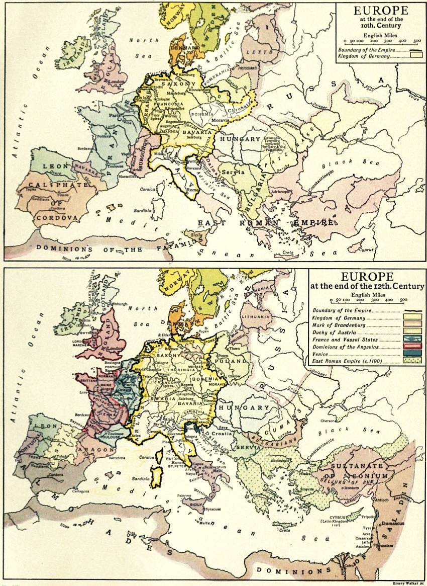
Farther west use was made at an early date of passes by which the whole system of the Alps could be crossed, or partly crossed and partly rounded, in a single rise. The ancient Etruscans, in exchanging their earthenware and bronzes for the amber found largely in those times not only in the Baltic but also on the eastern shores of the North Sea north of the Rhine mouths, made regular use of at least three such passes. One of these was the Brenner, the summit of which is under 4500 ft. in height, approached on the south side by the valley of the Adige and its tributary the Eisak, on the other side by the Inn valley and that of its small tributary the Sill. By this route the Alps at about their widest are crossed with exceptional ease; and hence it was natural that it should have been used by the Etruscans to reach the amber shores of the Baltic, and in all subsequent periods in intercourse between central Europe and northern Italy. In their trade with the mouth of the Rhine the Etruscans appear to have used only the passes approached by the Dora Baltea, which leads equally to the Little St Bernard, to the south of Mont Blanc, and so to the Isère valley and the Rhone, and to the Great St Bernard, to the east of Mont Blanc, and so directly to the Rhone valley above the Lake of Geneva, by which route the remainder of the Alps could be rounded on the west and the Rhine valley reached by crossing the northern Jura. Roman roads were afterwards made across all these passes, although that across the Great St Bernard (the highest of all, above 8100 ft.) seems never to have been made practicable for carriages. The Romans also made use of three intervening passes by which in a single rise from the Po basin the heads of valleys leading right down to the head of Lake Constance could be reached. These were the Bernardino, Splügen and Septimer, to mention them in the order from west to east. By the Romans the Simplon was also made use of as affording the most direct connexion between Milan and the upper Rhone valley. All these passes were likewise in use in the middle ages when Venice and Genoa were the great intermediaries in the trade in pepper and spices and other Oriental products. The Brenner afforded the most direct connexion between Venice and southern Germany, on a route leading also to northern Germany by way of Ratisbon and afterwards the rivers of the Elbe basin, and finally (from the end of the 14th century) by a canal to Lübeck, which was the great distributing centre of these and other products for the Baltic. To take the most direct route to the Rhine valley and north-western Europe some other pass (the Seefeld or the Fern) in the Bavarian Alps had to be crossed and the Rhine valley reached by Augsburg, and thence either by way of Ulm or Frankfort. From Genoa the routes in the early middle ages were by way of Milan to the Lake of Constance, and thence by way of Ulm if the Rhine valley was the goal, and by way of Augsburg if it was the Baltic. The St Gotthard route, the most direct connexion between Milan and the north of the Alps, was added about the end of the 13th century. The Mont Cenis pass from an early date afforded the most direct connexion between Genoa and the middle Rhone valley by way of Turin. When modern carriage roads came to be built it was still the same routes that were chosen. The road across the Brenner, completed in 1772, was the first of these. The building of the great Swiss carriage roads across the passes in the early part of the 19th century was inaugurated by Napoleon’s road across the Simplon completed in 1805. A later paragraph will show that modern railways follow much the same, if not exactly the same, routes. On the early use of the Saône-Rhone valleys, and the route between the foot-hills of the Cevennes and the Pyrenees, it is not necessary to insist, but it may be mentioned that English tin was sometimes conveyed to the Mediterranean (Marseilles) by this latter route in Roman times.
Since the introduction of railways inland waterways have in most countries taken a very inferior position as means of transport. The articles on the different countries supply the necessary information with respect to those which have a purely national interest, Inland waterways. but here mention must be made of those which have significance as belonging to trans-European routes or have an international value. The importance of shortening the water-route between the opposite sides of the great European isthmus separating the Baltic and the Black Sea is brought into prominence by the constant revival of projects for a ship-canal connecting those coasts. A definite step taken with a view to carrying out such a project was the sanction given by the tsar in April 1905 for the appointment of a special commission to inquire into the practicability of a scheme for the excavation of a canal about 28 ft. deep between Riga and Kherson, utilizing the waters of the Duna or western Dvina, the Berezina and Dnieper. Since the completion in 1845 of the Ludwigs or Danube-Main Canal, running from the Main near Bamberg to Kelheim on the Danube, it has been possible to go by water from the mouth of the Rhine to the mouth of the Danube; but this canal has in reality no trans-European significance. It cannot take barges of a greater capacity than 125 tons, is not adapted for steamers, and carries only a very small amount of traffic. But projects for connecting the Danube with northern Europe by water are still entertained. Of these the most advanced are those for establishing connexions through Austria. On the 11th of June 1901 the Austrian diet passed an act prescribing the construction of a canal connecting the Oder with the Danube through the Morava, and another connecting the Danube at Linz with the Moldau-Elbe, and the improvement of the navigation on the connected waterways. The Oder-Danube canal thus authorized would have to cross a watershed of little more than 1000 ft. in altitude as against 1365 ft. in the case of the Ludwigs Canal; but the Elbe-Danube Canal would have to cross one of about 2250 ft. Under the provisions of the act the work is to be completed by 1924. In Germany projects have been actively agitated for improving the Danube-Main connexion either wholly or partly along the route of the present canal, and for establishing a new connexion by means of a canal of at least 6½ ft. in depth by way of the Neckar, the Rems and the Brenz, joining the Danube at Lauingen about midway between Ulm and Donauwörth. The Moldau-Elbe is itself an important international waterway, inasmuch as it allows of steamer traffic from Prague in Bohemia to Hamburg, and by means of a connecting canal to Lübeck. But the most important of all international waterways in Europe is the Rhine, on which even sea-going steamers regularly ascend to Cologne, and an amount of traffic crosses the Dutch frontier three or four times as great as that which makes use of the Manchester ship-canal. The river is also navigable to Basel in Switzerland, though above Strassburg the river is little used, being replaced since 1834 by the Rhine and Rhone canal, which connects the two rivers through the Ill and the Saône. The Rhine is also connected with the Seine by the Marne and Rhine canal passing north of the Vosges, and its tributary the Moselle is also navigable from France into Germany. The Meuse again is navigable from France through Belgium into Holland, and is connected by more than one route with the Seine, and in the densely peopled mining and manufacturing country in the north of France and the adjoining parts of Belgium numerous waterways ramify in different directions. Even in an article on Europe the entirely French canals connecting the Seine and Rhone (Burgundy canal, summit-level 1230 ft., completed 1832), the Loire and Rhone (Canal du Centre, summit-level 990 ft., completed in 1793), and the Canal du Midi, connecting the Garonne at Toulouse with Cette on the Mediterranean, may be mentioned inasmuch as they establish communication between different seas. The last is of special interest because it is the oldest (completed in 1681), because it makes use of the lowest crossing, surmounting the passage of Naurouse, or Gap of Carcassonne, at an altitude of 625 ft., and because it effects the greatest shortening of distance from sea to sea. On this account the project of establishing a ship-canal of modern dimensions along this route has been as often revived as that of the Black Sea and Baltic canal. In the east of Europe the Vistula and Memel are both international waterways, but they are of little importance compared with those in the west. The Kaiser Wilhelm or North Sea and Baltic canal, opened in 1895, has, however, no little international value, inasmuch as it shortens the sea-route to the Baltic for all North Sea ports to the south of Newcastle, and affords the means of avoiding a rather dangerous passage round the north of Jutland. A minor degree of international interest belongs to the ship-canal through the Isthmus of Corinth, opened on the 6th of August 1893.
The following Railways. table gives a summary statement of the progress of railway construction in European countries down to the end of the 19th century:—
Railways in European Countries.
Date of opening of first line. Miles open.
1875. 1880. 1885. 1890. 1895. 1900.
Austria 1837 6,402 7.083 8,270 9,506 10,180 11,912
Belgium 1835 2,171 2,399 2,740 2,810 2,839 2,851
Bosnia-Herzegovina 1879 .. .. .. 342 471 ..
Bulgaria 1866 .. .. .. .. 535 921
Denmark 1847 689 975 1,195 1,217 1,371 1,809
France 1828 13,529 16,275 20,177 20,666 22,505 26,739
German Empire 1835 17,376 20,693 22,640 25,411 27,392 30,974
Great Britain 1825 14,510 15,563 16,594 17,281 18,001 18,680
Greece 1869 7 7 278 452 ? 641
Hungary 1846 3,992 4,421 5,605 6,984 8,651 10,624
Ireland 1834 2,148 2,370 2,575 2,792 3,173 3,183
Italy 1836 4,771 5,340 6,408 7,983 9,579 9,864
Luxemburg 1873 110 .. .. .. 270 ..
Netherlands 1839 1,006 1,143 1,496 1,653 1,869 2,007
Norway 1854 345 652 970 970 1,071 1,231
Portugal 1856 643 710 949 1,316 1,336 1,346
Rumania 1869 766 859 1,100 1,590 1,617 1,920
Russia* 1838 12,166 14,026 15,934 18,059 21,948 27,345
Servia 1884 .. .. 155 335 335 355
Spain 1848 3,801 4,550 5,547 6,211 7,483 8,206
Sweden 1856 2,171 3,654 4,279 4,980 6,058 7,018
Switzerland 1844 1,257 1,596 1,795 2,014 2,233 2,401
Turkey 1872 .. 727 657 657 935 ..
* Excluding Finland.
The chief railways of most European countries are on the same gauge as that originally adopted in Great Britain, namely, 4 ft. 8½ in. Irish railways are, however, on the gauge of 5 ft. 3 in. The standard gauge in Russia is 5 ft., that of Spain and Portugal about 5 ft. 6 in. The still isolated railway system of Greece is upon a narrow gauge. The very general use of a common gauge obviously greatly facilitates international trade. It allows, for example, of wagons from Germany entering every country on its frontier except Russia. It allows of German coal being carried without break of bulk to Paris, Milan and the mainland of Denmark. By means of train-ferries German trains can also be conveyed to Copenhagen by way of Warnemünde and Gjedser and then across the channel separating Falster and Zealand; and there is a similar means of communication between Copenhagen and Malmö (Sweden) and between Lindau in Bavaria on the Lake of Constance and Romanshorn on the same lake in the Swiss canton of Thurgau. The establishment of this method of transport between England and France has been urged in opposition to the Channel Tunnel scheme.
Of the railway systems of the mainland of Europe as a whole the main features are these. There is a broad belt running from the North Sea eastwards between the lines marked by Amsterdam and Hanover on the north, and Calais, Liége, Düsseldorf and Halle on the south, in which important lines of railway run from west to east. About 12° E. those lines begin to converge on Berlin. This belt is crossed in the Rhine valley by a much narrower but very important belt running north and south, now connected with the Italian railway system through the St Gotthard tunnel. To the south of the west end of the west-to-east belt lies the principal railway focus in western Europe, Paris, from which important lines radiate in all directions; two of these radiating lines now establish communication with the Italian railway system, through the Mont Cenis and Simplon tunnels respectively, and other two connecting with the Spanish system round the ends of the Pyrenees. Berlin in central Europe is perhaps an even more important railway focus. Among the chief lines radiating from it are one through Leipzig and Munich and connecting with the Italian railway system by the Brenner route, and another through Dresden and Prague to Vienna, and then by the Semmering pass by one route to Triest and by another to Venice. East of Berlin the railways of Europe begin to form wider meshes. Two main lines diverge towards the north-east, one by Küstrin and Königsberg and the other by Frankfort on the Oder and Thorn, both uniting at Eydtkühnen to the east of Königsberg before crossing the Prussian frontier and passing on to St Petersburg. From Thorn a line branches off by Warsaw to Moscow, the chief railway focus in eastern Europe. South-east from Berlin there runs another important line through Breslau, Cracow and Lemberg to Odessa, skirting to a large extent the foot-hills of the Carpathians like the ancient trade route from Olbia to the Baltic. Two routes on which there are services organized by the International Sleeping Car Company connect London with Constantinople, and it is noteworthy that both of these indicate the importance of the physical feature which has determined the position of the great north-south belt of railways above mentioned, and also of towns famous as commercial centres in the middle ages. One of these is the route of the Orient Express, which goes by Calais, Paris and Strassburg, then east of Strassburg runs north in the Rhine valley for about 40 m. to Karlsruhe, then winds through the hilly country between the Black Forest proper and the Odenwald to Stuttgart, proceeding thence by Ulm, Augsburg and Munich to Linz and then by the valley of the Danube through Vienna and Budapest to Belgrade, and thence by the valleys of the Morava, Nishava and Maritza to Constantinople. The other is that of the Ostend-Vienna express, going by Ostend to Brussels, and through Aix-la-Chapelle to Cologne, then up the Rhine gorge southwards to Bingen and eastwards to Mainz and on to Frankfort (on the Main), thence south-eastwards by the route so celebrated in the middle ages through Nuremberg to Regensburg (Ratisbon), and thence down the valley of the Danube coinciding with the Orient Express route from a point a few miles above Linz. From the Orient Express route a branch crosses from the valley of the Morava to that of the Vardar, establishing a connexion with Salonica.
In the development of this railway system the mountains have proved the most formidable of natural obstacles, and at the head of the mountains in this respect as in others stand the Alps. The first railway to cross one of the main chains of the Alps was the Semmering line on the route from Vienna to the Adriatic, constructed in 1848-1854. Its summit is in a tunnel less than 1 m. long, 2940 ft. above sea-level or nearly 300 ft. below the level of the pass. South of the Semmering, however, various other passes have to be crossed, and it was not till 1857 that the railway to Triest (by Laibach) was completed, and not till the late seventies that the more direct route to Venice across the Tarvis pass in Carinthia was established. Of the route from Triest by Görz across the Karawanken and Tauern Alps to Salzburg and south-eastern Germany the first section was opened only in 1906. After the Semmering the next railway to cross the Alps was that following the Brenner route which crosses the summit of the pass at the height of 4490 ft., and, as already stated, is the only pass that has to be crossed on the way from Munich to the plains of Italy. Next followed in 1871 the western route through the so-called Mont Cenis tunnel, really under the Col de Fréjus, to the west of the Mont Cenis pass, and effecting a crossing between the valleys of the Arc (Rhone basin) and the Dora Riparia (Po basin) at an altitude of 4380 ft., or nearly 2500 ft. lower than the pass previously used, but only by piercing the mountains in a tunnel more than 7½ m. long. Next in order was the St Gotthard route, opened in 1882, the most direct route between northern Italy and western Germany, connecting the Lake of Lucerne with the valley of the Ticino. Here the altitude is reduced to 3785 ft., about 3150 ft. below the summit-level of the pass, but the tunnel length is increased to rather more than 9¼ m. The Simplon route opened in June 1906, between the upper Rhone valley and the Toce valley, shortening the route between Milan and northern France, effects the crossing at an altitude of only 2300 ft., nearly 4300 ft. lower than the pass, but by increasing the tunnel length to 12¼ m. Steps were subsequently taken to continue the Simplon route northwards by a tunnel through the Lötschberg in the Bernese Alps, and a project is entertained for continuing the Vintschgau (upper Adige) railway across or under the Reschenscheideck to the Inn valley. An important east-west crossing of the Alps was effected when the Arlberg tunnel (6.37 m. long, summit-level 4300 ft.) connecting the Inn valley with that of the Rhine above the Lake of Constance was opened in 1884.
Several lines wind through and cross the Jura. That which in 1857 pierced the Hauenstein, in the north of Switzerland, attained international importance on the opening of the St Gotthard tunnel, inasmuch as it lies on the route thence through Lucerne to the Rhine valley at Basel; and that which crosses the Col de Jougne between Vallorbe and Pontarlier acquired similar importance on the completion of the Simplon tunnel. Further projects are entertained for shortening the connexion between this tunnel and the north of France by making a more direct line from Vallorbe to the French side of the Jura, or by making a railway across or under the Col de la Faucille (4340 ft.), north-west of Geneva.
Of the two railways that pass round the extremity of the Pyrenees, the western was the first to be constructed, the eastern was not opened till 1878. Hitherto the intervening mountains have proved more of a railway barrier than the mightier system of the Alps, but in 1904 a convention was concluded between the French and Spanish governments providing for the establishment of railway connexion between the two countries at three points of the great chain.
There are several railways across the Carpathians, mostly by passes under 3000 ft. in height. The fact that the Tömös Pass, on the direct route from Hungary through Transylvania to Bucharest, attains an altitude of 3370 ft. was undoubtedly one reason why the railway following this route, completed in December 1879, passing through several tunnels, was one of the last to be constructed. But the obstruction of mountains has not been the only cause of delay in the building of railways. Sparseness of population and general economic backwardness have also proved hindrances, especially in Russia and the Balkan Peninsula. The railways to Constantinople and Salonica were completed only in 1888, and yet the highest altitude on the Constantinople line is only 2400 ft., that on the Salonica line 1750 ft. Among other important railways of recent date and of more than merely national significance may be mentioned that bringing Bucharest into connexion with the Black Sea port of Costantza by means of a bridge across the Danube at Chernavoda (opened in September 1895); a line across the Carpathians connecting Debreczen with Lemberg, the continuation of the line eastwards from Lemberg to Kiev; a network bringing the coalfield of the Donets basin into connexion with ports on the Sea of Azov; a line in the south-east of Russia connecting Novocherkask with Vladikavkaz, and branches running from the same point connecting that line with Novorossiysk on the Black Sea on the one hand, and with Tsaritsyn at the last angle of the Volga on the other hand; a line in northern Russia bringing Archangel into connexion with the European system at Vologda (opened in 1898); a detached line in the north-east across the Urals from Perm by Ekaterinburg (completed in 1878) to Tyumeñ (completed in 1884). Chelyabinsk on the Siberian railway has a branch running northwards to Ekaterinburg, and this line now affords uninterrupted communication with the northern Dvina, inasmuch as the railway which originally started at Perm has been carried westwards through Vyatka and then northwards to Kotlas at the point of origin of that river, to which point it was opened in 1900; and a line in the east connecting the European system at Samara with the great mining centre at Zlatoust, already in 1890 continued across the Urals to Miyas, and since then carried farther east as the great Siberian railway.
The result of the construction of the numerous transcontinental railways has been to bring rail and sea-routes and ports on opposite sides of the continents into competition with one another to a greater degree than is possible in any other continent. The more valuable, and above all perishable commodities may be sent right across the continent even through the mountains. Even from Great Britain, which is bound to carry on its external commerce in part by sea, goods are sometimes sent far south in Italy by railways running from one or other of the North Sea ports. It will hence be readily understood that for inland trade on the mainland the competition between ports on opposite sides of the continent and between different railways will be very keen, greatly to the advantage of the inland centres to which that competition extends. This competition is inevitably all the more keen now that the trade of Europe with the East is once more carried on through the Mediterranean as it was in ancient times and the middle ages. The great shortening of the sea-route in this trade at such ports as Marseilles, Triest, Venice and Genoa, indicated by the figures below, goes far to counterbalance the extra cost even of railway transport across the mountains.
Distance in Nautical Miles from Port Said.
London 3215 Marseilles 1506
Bremen 3502 Genoa 1426
Hamburg 3520 Venice 1330
Stettin 3749 Brindisi 930
St Petersburg 4300 Odessa 1130
An enormous amount of investigation with regard to European ethnology has been carried on in recent years. These labours have chiefly consisted in the study of the physical type of different countries or districts, but it is not necessary Ethnology. to consider in detail the results arrived at. It should, however, be pointed out that the idea of an Aryan race may be regarded as definitely abandoned. One cannot even speak with assurance of the diffusion of an Aryan civilization. It is at least not certain that the civilization that was spread by the migration of peoples speaking Aryan tongues originated amongst and remained for a time peculiar to such peoples. The utmost that can be said is that the Aryan languages must in their earliest forms have spread from some geographical centre. That centre, however, is no longer sought for in Asia, but in some part of Europe, so that we can no longer speak of any detachment of Aryan-speaking peoples entering Europe.
The most important works, summarizing the labours of a host of specialists on the races of Europe, are those of Ripley and Deniker.72 Founding upon a great multitude of data that have been collected with regard to the form of the head, face and nose, height, and colour of the hair and eyes, most of the leading anthropologists seem to have come to the conclusion that there are three great racial types variously and intricately intermingled in Europe. As described and named by Ripley, these are: (1) the Teutonic, characterized by long head and face and narrow aquiline nose, high stature, very light hair and blue eyes; (2) the Alpine, characterized by round head, broad face, variable rather broad heavy nose, medium height and “stocky” frame, light chestnut hair and hazel grey eyes; and (3) the Mediterranean, characterized by long head and face, rather broad nose, medium stature and slender build, dark brown or black hair and dark eyes. The Teutonic race is entirely confined to north-western Europe, and embraces some groups speaking Celtic languages. It is believed by Ripley to have been differentiated in this continent, and to have originally been one with the other long-headed race, sometimes known as the Iberian, and to the Italians as the Ligurian race, which “prevails everywhere south of the Pyrenees, along the southern coast of France, and in southern Italy, including Sicily and Sardinia,” and which extends beyond the confines of Europe into Africa. The Alpine race is geographically intermediate between these two, having its centre in the Alps, while in western Europe it is spread most widely over the more elevated regions, and in eastern Europe “becomes less pure in proportion as we go east from the Carpathians across the great plains of European Russia.” This last race, which is most persistently characterized by the shape of the head, is regarded by Ripley as an intrusive Asiatic element which once advanced as a wedge amongst the earlier long-headed population as far as Brittany, where it still survives in relative purity, and even into Great Britain, though not Ireland, but afterwards retired and contracted its area before an advance of the long-headed races. Deniker, basing his classification on essentially the same data as Ripley and others, while agreeing with them almost entirely with regard to the distribution of the three main traits (cephalic index, colour of hair and eyes, and stature) on which anthropologists rely, yet proceeds further in the subdivision of the races of Europe. He recognizes six principal and four secondary races. The six principal races are the Nordic (answering approximately to the Teutonic of Ripley), the Littoral or Atlanto-Mediterranean, the Ibero-Insular, the Oriental, the Adriatic or Dinaric and the Occidental or Cevenole.
Although language is no test of race, it is the best evidence for present or past community of social or political life; and nothing is better fitted to give a true impression of the position and relative importance of the peoples of Language. Europe than a survey of their linguistic differences and affinities.73 The following table contains the names of the various languages which are still spoken on the continent, as well as of those which, though now extinct, can be clearly traced in other forms. Two asterisks are employed to mark those which are emphatically dead languages, while one indicates those which have a kind of artificial life in ecclesiastical or literary usage.
I. INDO-EUROPEAN.
1. Indic branch, represented by Gipsy dialects.
2. Iranic branch, represented by (a) Ossetian.
(b) Armenian.
3. Hellenic branch, represented by *(a) Greek.
(b) Romaic.
(c) Neo-Hellenic.
4. Italic branch, represented by *(a) Latin.
**(b) Oscan.
**(c) Umbrian, &c.
Neo-Latin (d) French.
(e) Walloon.
(f) Provençal.
(g) Italian.
(h) Ladin (Rumonsh, Rumansh, Rheto-Romance).
(i) Spanish.
(j) Portuguese.
(k) Rumanian.
5. Celtic branch, represented by (a) Irish.
(b) Erse or Gaelic.
(c) Manx.
(d) Welsh.
**(e) Cornish.
(f) Low Breton.
6. Teutonic branch, represented by **(a) Gothic.
Scandinavian **(b) Norse or Old Norse.
(c) Icelandic and Faeroese.
(d) Norwegian.
(e) Swedish.
(f) Danish.
Low German **(g) Saxon, Anglo-Saxon, or First English.
(h) English.
**(i) Old Saxon.
(j) Platt-Deutsch or Low German.
(k) Flemish Netherlandish.
(l) Dutch
(m) Frisic.
High German **(n) Old High German.
(o) Middle High German.
(p) New High or Literary German
7. Slavonic branch, represented by *(a) Church Slavonic.
South-Eastern (b) Russian.
(c) Ruthenian, Rusniak, or Little-Russian.
(d) White Russian or Bielo-Russian.
(e) Bulgarian.
(f) Servo-Croatian.
(g) Slovenian.
Western (h) Czech (Bohemian).
(i) Slovakish.
(j) Polish.
(k) Sorbian (Wendic, Lusatian).
*(l) Polabian.
8. Lettic branch, represented by **(a) Old Prussian
(b) Lettish.
(c) Lithuanian.
9. Unattached **?(a) Old Dacian.
(b) Albanian.
II. SEMITIC.
1. Canaanitic branch, represented by *(a) Hebrew.
**(b) Phoenician or Punic.
2. Arabic branch, represented by **(a) Arabic.
**(b) Mozarabic.
(c) Maltese.
III. FINNO-TATARIC (Turanian, Ural-Altaic, &c.).
1. Finno-Ugric languages (a) Samoyede.
(b) Finnish or Suomi.
(c) Esthonian, Livonian, Vepsish, Votish.
(d) Lappish.
(e) Cheremissian.
(f) Mordvinian.
(g) Ziryenian and Permian.
(h) Votiak.
(i) Magyar.
2. Tatar-Turkish languages (a) Turkish.
(b) Kazan Tatar, Crimean Tatar, Bashkir, Kirghiz.
(c) Chuvash.
3. Mongolian languages Kalmuk.
4. Unattached Basque.
From this conspectus it appears that there are still about 60 distinct languages spoken in Europe, without including Latin, Greek, Old Slavonic and Hebrew, which are still used in literature or ecclesiastical liturgies. Besides all those which are spoken over extensive territories, and some even which are confined within very narrow limits, are broken up into several distinct dialects.
The boundaries of European countries have of course been determined by history, and in some cases only historical events can be held to account for their general situation, the influence of geographical conditions being seen Political boundaries. only on a minute examination of details. In most cases, however, it is otherwise. The present political boundaries were all settled when the general distribution of population in the continent was in a large measure determined by the geographical conditions, and accordingly the lines along which they run for the most part show the influence of such conditions very clearly, and thus present in many cases a marked contrast to the political boundaries in America and Australia, where the boundaries have often been marked out in advance of the population. In Europe the general rule is that the boundaries tend to run through some thinly peopled strip or tract of country, such as is formed by mountain ranges, elevated tablelands too bleak for cultivation, relatively high ground of no great altitude where soil and climate are less favourable to cultivation than the lower land on either side, or low ground occupied by heaths or marshes or some other sterile soil; but it is the exception for important navigable rivers to form boundaries between countries or even between important administrative divisions of countries, and for such exceptions a special explanation can generally be found. Navigable rivers unite rather than separate, for the obvious reason that they generally flow through populous valleys, and the vessels that pass up and down can touch as easily on one side as the other. Minor rivers, on the other hand, flowing through sparsely peopled valleys frequently form portions of political boundaries simply because they are convenient lines of demarcation. A brief examination of the present political map of Europe will serve to illustrate these rules.
The eastern frontier of the Netherlands begins by running southwards through a marsh nearly parallel to the Ems but nowhere touching it, then winds south or south-westwards through a rather sparsely peopled district to the Rhine. This river it crosses, it then approaches but does not touch the Meuse, but runs for a considerable distance roughly parallel to that river along higher ground, where the population is much more scanty than in the valley. On the side of Belgium the Dutch boundary is for the most part thoroughly typical, winding between the dreariest parts of the Dutch or Belgium provinces of North Brabant, Limburg and Antwerp. The Scheldt nowhere forms a boundary between countries, not even at its wide estuary. The eastern frontier of Belgium is quite typical both on the side of Germany and Luxemburg. It is otherwise, however, on the south, there that country confines with France, and indeed the whole of the north-east frontier of France may be called a historical frontier, showing the influence of geographical conditions only in details. One of these details, however, deserves attention, the tongue in which it advances northwards into Belgium so as to give to France the natural fortress of Givet, a tongue, be it noted, the outline of which is as typical a boundary as is to be seen in Europe in respect of scantiness of population, apart from the fortress.
The mountainous frontiers of France on the east and south require hardly any comment. Only in the Burgundy Gate between the Vosges and the Jura has an artificial boundary had to be drawn, and even that in a minor degree illustrates the general rule. The division of the Iberian peninsula between Spain and Portugal goes back in effect to the Christian reaction against the Moors. The valley of the Miño and its tributaries establishes a natural connexion between Galicia and the rest of Spain; but an independent crusade against the Moors starting from the lower part of the valley of the Douro resulted in the formation of the kingdom of Portugal, which found its natural eastern limit on the scantily peopled margin of the Iberian tableland, where the rivers cease to be navigable and flow through narrow gorges, that of the Tagus, where the river marks the frontier, being almost without inhabitants, especially on the Spanish side.
The greater part of the Italian boundary is very clearly marked geographically, though we have to look back to the weakness of divided Italy to account for the instances in which northern mountaineers have pushed their way into southern Alpine valleys. Even in these parts, however, there are interesting illustrations of geographical influence in the way in which the Italian boundary crosses the northern ends of the Lago Maggiore and the Lake of Garda, and cuts off portions of Lake Lugano both in the east and west. In all these cases the frontier crosses from one steep unpeopled slope to another, assigning the population at different ends or on different sides of the lakes to the country to which belongs the adjacent population not lying on their shores.
Of the Swiss frontiers all that it is necessary to remark is that the river Rhine in more than one place marks the boundary, in one, however, where it traverses alluvial flats liable to inundation (on the side of Austria), in the other place where it rushes through a gorge below the falls of Schaffhausen. The southern frontier of Germany is almost throughout typical, the northern is the sea, except where a really artificial boundary runs through Jutland.
In the east of Germany and the north-east of Austria the winding frontier through low plains is the result of the partition of Poland, but in spite of the absence of marked physical features it is for the most part in its details almost as typical as the mountainous frontier on the south of Germany. All the great rivers are crossed. Most of the line runs through a tract of strikingly scanty population, and the dense population in one part of it, where upper Silesia confines with Russian Poland, has been developed since the boundary was fixed.
In the Balkan Peninsula the most striking facts are that the Balkans do not, and the Danube to a large extent does form a boundary. Geographical features, however, bring the valley of the Maritsa (eastern Rumelia) into intimate relation with upper Bulgaria, the connexion of which with Bulgaria north of the Balkans had long been established by the valley of the Isker, narrow as that valley is. On the side of Rumania, again, it is the marshes on the left bank of the Danube even more than the river itself that make of that river a frontier. An examination of the eastern boundary of all that is included in Russia in Europe will furnish further illustrations of the general rule.
Finally, on the north-west of Russia it was only natural that the Tornea and the Tana should be taken as lines of demarcation in that thinly peopled region, and it was equally natural that where the boundary between Norway and Sweden descends from the fjeld in the south it should leave to Norway both sides of the valley of the Glommen.
Countries. Area. Population. Pop. per sq. m.
English sq. m. About 1880. About 1890. About 1900.
Austria-Hungary 241,466 37,884 41,358 45,40511 188
Bosnia-Herzegovina(a) 19,735 1,3361 .. 1,56812 81
Liechtenstein 61 97 .. 147
Belgium 11,373 5,520 6,069 6,69416 589
Denmark(b) 15,431 1,980 2,185 2,46514 160
France 207,206 38,3437 38,59614 186
Monaco 8 .. .. 1513 ..
German Empire 208,760 45,234 49,428 56,34516 270
Luxemburg 1,003 23716 247
Greece 24,974 2,1878 2,43415 97
Italy 110,676 28,4602 32,45014 293
San Marino 23 .. 1117 435
Montenegro 3,500 .. 22815 65
Netherlands 12,741 4,0133 4,5118 5,10317 400
Portugal 34,347(c) 4,1604 4,660 5,42316 153
Rumania 50,588 5,91317 117