Chapter II
Reading edition
RUINS AND INHABITED VILLAGES OF TUSAYAN.
PHYSICAL FEATURES OF THE PROVINCE.
That portion of the southwestern plateau country comprised in the Province of Tusayan has usually been approached from the east, so that the easternmost of the series of mesas upon which the villages are situated is called the “First Mesa.” The road for 30 or 40 miles before reaching this point traverses the eastern portion of the great plateau whose broken margin, farther west, furnishes the abrupt mesa-tongues upon which the villages are built. The sandstone measures of this plateau are distinguished from many others of the southwest by their neutral colors. The vegetation consisting of a scattered growth of stunted piñon and cedar, interspersed with occasional stretches of dull-gray sage, imparts an effect of extreme monotony to the landscape. The effect is in marked contrast to the warmth and play of color frequently seen elsewhere in the plateau country.
The plateaus of Tusayan are generally diversified by canyons and buttes, whose precipitous sides break down into long ranges of rocky talus and sandy foothills. The arid character of this district is especially pronounced about the margin of the plateau. In the immediate vicinity of the villages there are large areas that do not support a blade of grass, where barren rocks outcrop through drifts of sand or lie piled in confusion at the bases of the cliffs. The canyons that break through the margins of these mesas often have a remarkable similarity of appearance, and the consequent monotony is extremely embarrassing to the traveler, the absence of running water and clearly defined drainage confusing his sense of direction.
The occasional springs which furnish scanty water supply to the inhabitants of this region are found generally at great distances apart, and there are usually but few natural indications of their location. They often occur in obscure nooks in the canyons, reached by tortuous trails winding through the talus and foothills, or as small seeps at the foot of some mesa. The convergence of numerous Navajo trails, however, furnishes some guide to these rare water sources.
The series of promontories upon which the Tusayan villages are built are exceptionally rich in these seeps and springs. About the base of Fig. 1), within a distance of 4 or 5 miles from the villages located upon it, there are at least five places where water can be obtained. One of these is a mere surface reservoir, but the others appear to be permanent springs. The quantity of water, however, is so small that it produces no impression on the arid and sterile effect of the surroundings, except in its immediate vicinity. Here small patches of green, standing out in strong relief against their sandy back-grounds, mark the position of clusters of low, stunted peach trees that have obtained a foothold on the steep sand dunes.
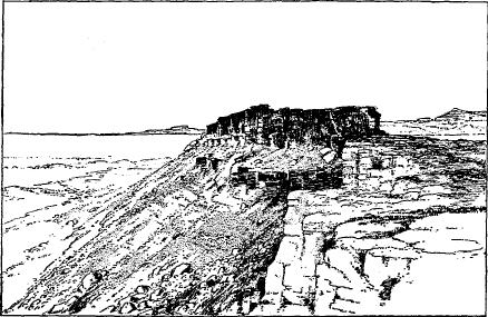
Fig. 1. View of the First Mesa.
In the open plains surrounding the mesa rim (6,000 feet above the sea), are seen broad stretches of dusty sage brush and prickly greasewood. Where the plain rises toward the base of the mesa a scattered growth of scrub cedar and piñon begins to appear. But little of this latter growth is seen in the immediate vicinity of the villages; it is, however, the characteristic vegetation of the mesas, while, in still higher altitudes, toward the San Juan, open forests of timber are met with. This latter country seems scarcely to have come within the ancient builder’s province; possibly on account of its coldness in winter and for the reason that it is open to the incursions of warlike hunting tribes. Sage brush and greasewood grow abundantly near the villages, and these curious gnarled and twisted shrubs furnish the principal fuel of the Tusayan.
Occasionally grassy levels are seen that for a few weeks in early summer are richly carpeted with multitudes of delicate wild flowers. The beauty of these patches of gleaming color is enhanced by contrast with the forbidding and rugged character of the surroundings; but in a very short time these blossoms disappear from the arid and parched desert
After crossing the 6 or 7 miles of comparatively level country that intervenes between the mouth of Keam’s Canyon and the first of the occupied mesas, the toilsome ascent begins; at first through slopes and dunes and then over masses of broken talus, as the summit of the mesa is gradually approached. Near the top the road is flanked on one side by a very abrupt descent of broken slopes, and on the other by a precipitous rocky wall that rises 30 or 40 feet above. The road reaches the brink of the promontory by a sharp rise at a point close to the village of Hano.
METHODS OF SURVEY.
Before entering upon a description of the villages and ruins, a few words as to the preparation of the plans accompanying this paper will not be amiss. The methods pursued in making the surveys of the inhabited pueblos were essentially the same throughout. The outer wall of each separate cluster was run with a compass and a tape measure, the lines being closed and checked upon the corner from which the beginning was made, so that the plan of each group stands alone, and no accumulation of error is possible. The stretched tapeline afforded a basis for estimating any deviations from a straight line which the wall presented, and as each sight was plotted on the spot these deviations are all recorded on the plan, and afford an indication of the degree of accuracy with which the building was carried out. Upon the basis thus obtained, the outlines of the second stories were drawn by the aid of measurements from the numerous jogs and angles; the same process being repeated for each of the succeeding stories. The plan at this stage recorded all the stories in outline. The various houses and clusters were connected by compass sights and by measurements. A tracing of the outline plan was then made, on which the stories were distinguished by lines of different colors, and upon this tracing were recorded all the vertical measurements. These were generally taken at every corner, although in a long wall it was customary to make additional measurements at intervening points.
Upon the original outline were then drawn all such details as coping stones, chimneys, trapdoors, etc., the tapeline being used where necessary to establish positions. The forms of the chimneys as well as their position and size were also indicated on this drawing, which was finally tinted to distinguish the different terraces. Upon this colored sheet were located all openings. These were numbered, and at the same time described in a notebook, in which were also recorded the necessary vertical measurements, such as their height and elevation above the ground. In the same notebook the openings were also fully described. The ladders were located upon the same sheet, and were consecutively
These plans were primarily intended to be used in the construction of large scale models, and consequently recorded an amount of information that could not be reproduced upon the published drawings without causing great confusion.
The methods followed in surveying the ruins underwent some changes from time to time as the work progressed. In the earlier work the lines of the walls, so far as they could be determined, were run with a compass and tapeline and gone over with a level. Later it was found more convenient to select a number of stations and connect them by cross-sights and measurements. These points were then platted, and the walls and lines of débris were carefully drawn in over the framework of lines thus obtained, additional measurements being taken when necessary. The heights of standing walls were measured from both sides, and openings were located on the plan and described in a notebook, as was done in the survey of the inhabited villages. The entire site was then leveled, and from the data obtained contour lines were drawn with a 5-foot interval. Irregularities in the directions of walls were noted. In the later plans of ruins a scale of symbols, seven in number, were employed to indicate the amount and distribution of the débris. The plans, as published, indicate the relative amounts of débris as seen upon the ground. Probable lines of wall are shown on the plan by dotted lines drawn through the dots which indicate débris. With this exception, the plans show the ruins as they actually are. Standing walls, as a rule, are drawn in solid black; their heights appear on the field sheets, but could not be shown upon the published plans without confusing the drawing. The contour lines represent an interval of 5 feet; the few cases in which the secondary or negative contours are used will not produce confusion, as their altitude is always given in figures.
PLANS AND DESCRIPTIONS OF RUINS.
The ruins described in this chapter comprise but a few of those found within the province of Tusayan. These were surveyed and recorded on account of their close traditional connection with the present villages, and for the sake of the light that they might throw upon the relation of the modern pueblos to the innumerable stone buildings of unknown date so widely distributed over the southwestern plateau country. Such
In our study of architectural details, when a comparison is suggested between the practice at Tusayan and that of the ancient builders, our illustrations for the latter must often be drawn from other portions of the builders’ territory where better preserved remains furnish the necessary data.
WALPI RUINS.
In the case of the pueblo of Walpi, a portion of whose people seem to have been the first comers in this region, a number of changes of sites have taken place, at least one of which has occurred within the historic period. Of the various sites occupied one is pointed out north of the gap on the first mesa. At the present time this site is only a low mound of sand-covered débris with no standing fragment of wall visible. The present condition of this early Walpi is illustrated in Fig. 2. In the absence of foundation walls or other definite lines, the character of the site is expressed by the contour lines that define its relief. Another of the sites occupied by the Walpi is said to have been in the open valley separating the first from the second mesa, but here no trace of the remains of a stone village has been discovered. This traditional location is referred to by Mr. Stephen in his account of Walpi. The last site occupied previous to the present one on the mesa summit was on a lower bench of the first mesa promontory at its southern extremity. Here the houses are said to have been distributed over quite a large area, and occasional fragments of masonry are still seen at widely separated points; but the ground plan can not now be traced. This was the site of a Spanish mission, and some of the Tusayan point out the position formerly occupied by mission buildings, but no architectural evidence of such structures is visible. It seems to be fairly certain, however, that
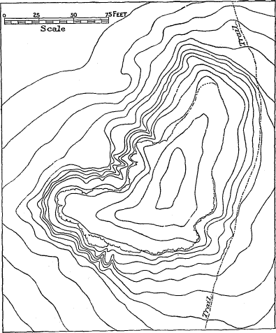
Fig. 2. Ruins, Old Walpi mound.
OLD MASHONGNAVI.
In the case of Mashongnavi we have somewhat more abundant material. It will be desirable to quote a few lines of narrative from the account of a Mashongnavi Indian of the name of Nuvayauma, as indicating the causes that led to the occupation of the site illustrated.
We turned and came to the north, meeting the Apache and “Beaver Indians,” with whom we had many battles, and being few we were defeated, after which we came
The ruins referred to as having been the first occupied by the Mashongnavi at a large isolated rock known as the “Giant’s Chair,” have not been examined. The later village from which they were driven by the attacks of the Apache to their present site has been surveyed. The plan of the fallen walls and lines of débris by which the form of much of the old pueblo can still be traced is given in Pl. II. The plan of the best preserved portion of the pueblo towards the north end of the sheet clearly indicates a general adherence to the inclosed court arrangement with about the same degree of irregularity that characterizes the modern village. Besides the clearly traceable portions of the ruin that bear such resemblance to the present village in arrangement, several small groups and clusters appear to have been scattered along the slope of the foothills, but in their present state of destruction it is not clear whether these clusters were directly connected with the principal group, or formed part of another village. Occasional traces of foundation walls strongly suggest such connection, although from the character of the site this intervening space could hardly have been closely built over. With the exception of the main cluster above described the houses occupy very broken and irregular sites. As indicated on the plan, the slope is broken by huge irregular masses of sandstone protruding from the soil, while much of the surface is covered by scattered fragments that have fallen from neighboring pinnacles and ledges. The contours indicate the general character of the slopes over which these irregular features are disposed. The fragment of ledge shown on the north end of the plate, against which a part of the main cluster has been built, is a portion of a broad massive ledge of sandstone that supports the low buttes upon which the present villages of Mashongnavi and Shupaúlovi are built, and continues as a broad, level shelf of solid rock for several miles along the mesa promontory. Its continuation on the side opposite that shown in the plate may be seen in the general view of Shupaulovi (Pl. XXXI).
SHITAIMUVI.
The vestiges of another ruined village, known as Shitaimuvi, are found in the vicinity of Mashongnavi, occupying and covering the crown of a rounded foothill on the southeast side of the mesa. No plan of this ruin could be obtained on account of the complete destruction of the walls. No line of foundation stones even could be found, although the whole area is more or less covered with the scattered stones of former masonry. An exceptional quantity of pottery fragments is also strewn I.
AWATUBI.
The ruin of Awatubi is known to the Navajo as Talla Hogan, a term interpreted as meaning “singing house” and thought to refer to the chapel and mission that at one time nourished here, as described by Mr. Stephen in Chapter I. Tradition ascribes great importance to this village. At the time of the Spanish conquest it was one of the most prosperous of the seven “cities” of Tusayan, and was selected as the site of a mission, a distinction shared by Walpi, which was then on a lower spur of the first mesa, and by Shumopavi, which also was built on a lower site than the present village of that name. Traditions referring to this pueblo have been collected from several sources and, while varying somewhat in less important details, they all concur in bringing the destruction of the village well within the period of Spanish occupation.
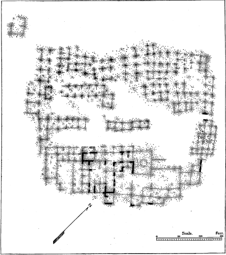
Plate IV. Awatubi (Talla-Hogan), plan.
On the historical site, too, we know that Cruzate on the occasion of the attempted reconquest of the country visited this village in 1692, and the ruin must therefore be less than two centuries old, yet the completeness of destruction is such that over most of its area no standing wall is seen, and the outlines of the houses and groups are indicated mainly by low ridges and masses of broken-down masonry, partly covered by the drifting sands. The group of rooms that forms the south east side of the pueblo is an exception to the general rule. Here fragmentary walls of rough masonry stand to a height, in some cases, of 8 feet above the débris. The character of the stonework, as may be seen from Pl. V, is but little better than that of the modern villages. This better preserved portion of the village seems to have formed part of a cluster of mission buildings. At the points designated A on the ground plan may be seen the remnants of walls that have been built of straw adobe in the typical Spanish manner. These rest upon foundations of stone masonry. See Pl. VI. The adobe fragments are probably part of the church or associated buildings. At two other points on the ground plan, both on the northeast side, low fragments of wall are still standing, as may be seen from the plate. At one of these points the remains indicate that the village was provided with a gateway near the middle of the northeast side.
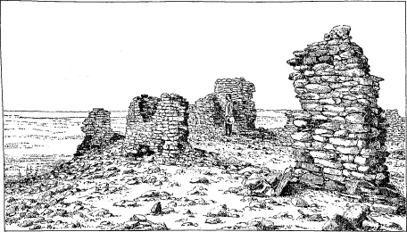
Plate V. Standing walls of Awatubi.
The general plan of this pueblo is quite different from that of the present villages, and approaches the older types in symmetry and compactness. There is a notable absence of the arrangement of rooms into long parallel rows. This typical Tusayan feature is only slightly approximated in some subordinate rows within the court. The plan suggests that the original pueblo was built about three sides of a rectangular
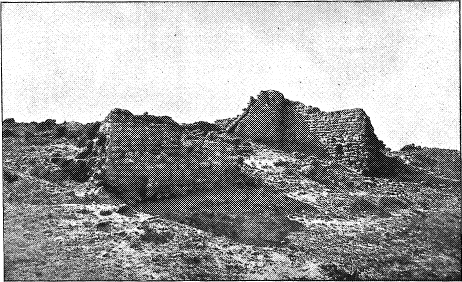
Plate VI. Adobe fragment in Awatubi.
Awatubi is said to have had excavated rectangular kivas, situated in the open court, similar to those used in the modern village. The people of Walpi had partly cleared out one of these chambers and used it as a depository for ceremonial plume-sticks, etc., but the Navajo came and carried off their sacred deposits, tempted probably by their market value as ethnologic specimens. No trace of these kivas was visible at the time the ruins were surveyed.
The Awatubi are said to have had sheep at the time the village was destroyed. Some of the Tusayan point out the remains of a large sheep corral near the spring, which they say was used at that time, but it is quite as likely to have been constructed for that purpose at a much later date.
HORN HOUSE.
The Horn House is so called because tradition connects this village with some of the people of the Horn phratry of the Hopituh or Tusayan. The ruin is situated on a projecting point of the mesa that forms the western flank of Jeditoh Valley, not far from where the Holbrook road to Keam’s Canyon ascends the brink of the mesa. The village is almost completely demolished, no fragment of standing wall remaining in place. Its general plan and distribution are quite clearly indicated by the usual low ridges of fallen masonry partly covered by drifted sand. There is but little loose stone scattered about, the sand having filled in all the smaller irregularities.
It will be seen from the plan, Pl. VII, that the village has been built close to the edge of the mesa, following to some extent the irregularities of its outline. The mesa ruin at this point, however, is not very high, the more abrupt portion having a height of 20 or 30 feet. Near the north end of the village the ground slopes very sharply toward the east and is rather thickly covered with the small stones of fallen masonry, though but faint vestiges of rooms remain. In plan the ruin is quite elongated, following the direction of the mesa. The houses were quite irregularly disposed, particularly in the northern portion of the ruin. But here the indications are too vague to determine whether the houses were originally built about one long court or about two or more smaller ones. The south end of the pueblo, however, still shows a well defined court bounded on all sides by clearly traceable rooms. At the extreme south end of the ruin the houses have very irregular outlines, a result of their adaptation to the topography, as may be seen in the illustration.
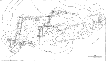
full size Plate VII. Horn House ruin, plan.
The plan shows the position of a small group of cottonwood trees, just below the edge of the mesa and nearly opposite the center of the
There are many fragments of pottery on this spot, but they are not so abundant as at Awatubi.
Two partly excavated rooms were seen at this ruin, the work of some earlier visitors who hoped to discover ethnologic or other treasure.
These afforded no special information, as the character of the masonry exposed differed in no respect from that seen at other of the Tusayan ruins. No traces of adobe construction or suggestions of foreign influence were seen at this ruin.
SMALL RUIN BETWEEN HORN HOUSE AND BAT HOUSE.
On a prolongation of the mesa occupied by the Horn House, midway between it and another ruined pueblo known as the Bat House, occur the remains of a small and compact cluster of houses (Fig. 3). It is situated on the very mesa edge, here about 40 feet high, at the head of a small canyon which opens into the Jeditoh Valley, a quarter of a mile below.
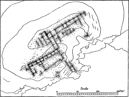
Fig. 3. Ruin between Bat House and Horn House.
The site affords an extended outlook to the south over a large part of Jeditoh Valley. The topography about this point, which receives the drainage of a considerable area of the mesa top, would fit it especially for the establishment of a reservoir. This fact probably had much
BAT HOUSE.
The Bat House is a ruin of nearly the same size as the Horn House, although in its distribution it does not follow the mesa edge so closely as the latter, and is not so elongated in its general form. The northern portion is quite irregular, and the rooms seem to have been somewhat crowded. The southern half, with only an occasional room traceable, as indicated on the plan, Pl. VIII, still shows that the rooms were distributed about a large open court.
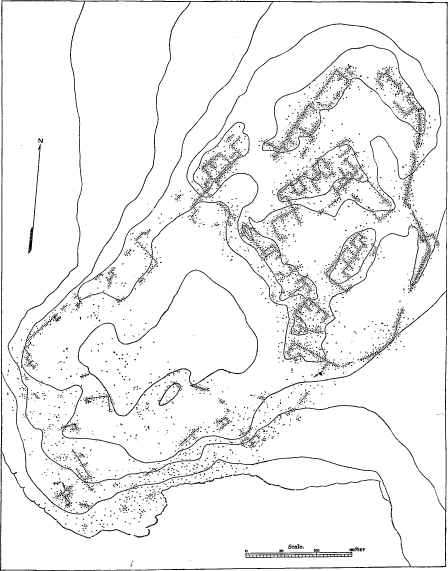
Plate VIII. Bat House.
The Bat House is situated on the northwest side of the Jeditoh Valley, on part of the same mesa occupied by the two ruins described above. It occupies the summit of a projecting spur, overlooking the main valley for an extent of more than 5 miles. The ruin lies on the extreme edge of the cliff, here about 200 feet high, and lying beneath it on the east and south are large areas of arable land. Altogether it forms an excellent defensive site, combined with a fair degree of convenience to fields and water from the Tusayan point of view.
This ruin, near its northeastern extremity, contains a feature that is quite foreign to the architecture of Tusayan, viz, a defensive wall. It is the only instance of the use by the Hopituh of an inclosing wall, though it is met with again at Payupki (Pl. XIII), which, however, was built by people from the Rio Grande country.
MISHIPTONGA.
Mishiptonga is the Tusayan name for the southernmost, and by far the largest, of the Jeditoh series of ruins (Pl. IX). It occurs quite close to the Jeditoh spring which gives its name to the valley along whose northern and western border are distributed the ruins above described, beginning with the Horn house.
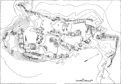
full size Plate IX. Mishiptonga (Jeditoh).
This village is rather more irregular in its arrangement than any other of the series. There are indications of a number of courts inclosed by large and small clusters of rooms, very irregularly disposed, but with a general trend towards the northeast, being roughly parallel with the mesa edge. In plan this village approaches somewhat that of the inhabited Tusayan villages. At the extreme southern extremity of the mesa promontory is a small secondary bench, 20 feet lower than the site of the main village. This bench has also been occupied by a number of houses. On the east side the pueblo was built to the very edge of the bluff, where small fragments of masonry are still standing. The whole village seems so irregular and crowded in its arrangement that it suggests a long period of occupancy and growth, much more than do the other villages of this (Jeditoh) group.
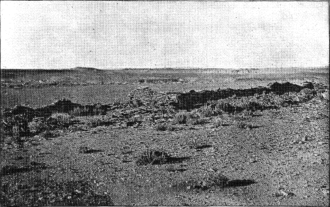
Plate X. A small ruin near Moen-kopi.
MOEN-KOPI RUINS.
A very small group of rooms, even smaller than the neighboring farming pueblo of Moen-kopi, is situated on the western edge of the mesa summit about a quarter of a mile north of the modern village of Moen-kopi. As the plan shows (Fig. 4), the rooms were distributed in three rows around a small court. This ruin also follows the general northeastern trend which has been noticed both in the ruined and in the occupied pueblos of Tusayan. The rows here were only one room deep and not more than a single story high at any point, as indicated by the very small amount of débris. As the plate shows, nearly the entire plan is clearly defined by fragments of standing walls. The walls are built of thin tablets of the dark-colored sandstone which caps the mesa. Where the walls have fallen the débris is comparatively free Pl. X, show unusual precision of workmanship and finish, resembling in this respect some of the ancient pueblos farther north. This is to some extent due to the exceptional suitability of the tabular stones of the mesa summit. The almost entire absence of pottery fragments and other objects of art which are such a constant accompaniment of the ruins throughout this region strongly suggest that it was occupied for a very short time. In Chapter III it will be shown that a similar order of occupation took place at Ojo Caliente, one of the Zuñi farming villages. This ruin is probably of quite recent origin, as is the present village of Moen-kopi, although it may possibly have belonged to an earlier colony of which we have no distinct trace. This fertile and well watered valley, a veritable garden spot in the Tusayan deserts, must have been one of the first points occupied. Some small cliff-dwellings, single rooms in niches of a neighboring canyon wall, attest the earlier use of the valley for agricultural purposes, although it is doubtful whether these rude shelters date back of the Spanish invasion of the province.
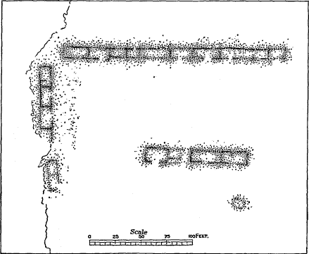
Fig. 4. Ruin near Moen-kopi, plan.
A close scrutiny of the many favorable sites in this vicinity would probably reveal the sand-encumbered remains of some more important settlement than any of those now known.
RUINS ON THE ORAIBI WASH.
The wagon road from Keam’s Canyon to Tuba City crosses the Oraibi wash at a point about 7 miles above the village of Oraibi. As it enters a branch canyon on the west side of the wash it is flanked on each side by rocky mesas and broken ledges. On the left or west side a bold promontory, extending southward, is quite a conspicuous feature of the landscape. The entire flat mesa summit, and much of the slope of a rocky butte that rises from it, are covered with the remains of a small pueblo, as shown on the plan, Fig. 5. All of this knoll except its eastern side is lightly covered with scattered débris. On the west and north sides there are many large masses of broken rock distributed over the slope. There is no standing wall visible from below, but on closer approach several interesting specimens of masonry are seen. On the north side, near the west end, there is a fragment of curved wall which follows the margin of the rock on which it is built. It is about 8 or 10 feet long and 3 feet high on the outer side. The curve is carefully executed and the workmanship of the masonry good. Farther east, and still on the north side, there is a fragment of masonry exhibiting a reversed curve. This piece of wall spans the space between two adjoining rocks, and the top of the wall is more than 10 feet above the rock on which it stands. The shape of this wall and its relation to the surroundings are indicated on the plan, Fig. 5. On the south side of the ruin on the mesa surface, and near an outcropping rock, are the remains
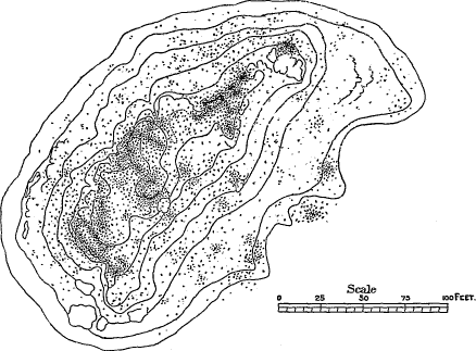
Fig. 5. Ruin 7 miles north of Oraibi.
In that portion of the ruin which lies on top of the knoll, the walls so far as traced conform to the shape of the site. The ground plan of the buildings that once occupied the slopes can not be traced, and it is impossible to determine whether its walls were carried through continuously.
The masonry exhibited in the few surviving fragments of wall is of unusually good quality, resembling somewhat that of the Fire House, Fig. 7, and other ruins of that class. The stones are of medium size, not dressed, and are rather rougher and less flat than is usual, but the wall has a good finish. The stone, however, is of poor quality. Most of the débris about the ruin consists of small stone fragments and sand, comparatively few stones of the size used in the walls being seen. The material evidently came from the immediate vicinity of the ruin.
Pottery fragments were quite abundant about this ruin, most of the ware represented being of exceptional quality and belonging to the older types; red ware with black lines and black and white ware were especially abundant.
KWAITUKI.
The ruin known to the Tusayan as Kwaituki (Fig. 6) is also on the west side of the Oraibi wash, 14 miles above Oraibi, and about 7 miles above the ruin last described. Its general resemblance to the latter is very striking. The builders have apparently been actuated by the same motives in their choice of a site, and their manner of utilizing it corresponds very closely. The crowning feature of the rocky knoll in this case is a picturesque group of rectangular masses of sandstone, somewhat irregularly distributed. The bare summit of a large block-like mass still retains the vestiges of rooms, and probably most of the groups were at one time covered with buildings, forming a prominent citadel-like group in the midst of the village. To the north of this rocky butte a large area seems to have been at one time inclosed by buildings, forming a court of unusual dimensions. Along the outer margin of the pueblo
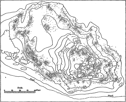
Fig. 6. Ruin 14 miles north of Oraibi (Kwaituki).
In the nearly level tops of some of the rocks forming the central pile are many smoothly worn depressions or cavities, which have evidently been used for the grinding and shaping of stone implements.
A remarkable feature occurring within this village is a cave or underground fissure in the rocks, which evidently had been used by the inhabitants. The mouth or entrance to this cavern, partly obstructed and concealed at the time of our visit, occurs at the point A on the plan. On clearing away the rubbish at the mouth and entering it was found so obstructed with broken rock and fine dust that but little progress could be made in its exploration; but the main crevice in the rock could be seen by artificial light to extend some 10 feet back from the mouth, where it became very shallow. It could be seen that the original cavern had been improved by the pueblo-builders, as some of the timbers that had been placed inside were still in position, and a low wall of masonry on the south side remained intact. Some Navajos stated that they had discovered this small cave a couple of years before and had taken from it a large unbroken water jar of ancient pottery and some other specimens. The place was probably used by the ancient occupants simply for storage.
Fragments of pottery of excellent quality were very abundant about this ruin and at the foot of the central rocks the ground was thickly strewn with fragments, often of large size.
The defensive character of this site parallels that of the ruin 7 miles farther south in quite a remarkable manner, and the villages were apparently built and occupied at the same time.
TEBUGKIHU, OR FIRE HOUSE.
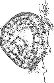
Fig. 7. Oval (Fire House) ruin, plan (Tebugkihu).
About 15 miles northeast of Keam’s Canyon, and about 25 miles from Walpi, is a small ruin called by the Tusayan “Tebugkihu,” built by people of the Fire gens (now extinct). As the plan (Fig. 7) clearly shows, this pueblo is very different from the typical Tusayan villages that have been previously described. The apparent unity of the plan, and the skillful workmanship somewhat resembling the pueblos of the Chaco are in marked contrast to the irregularity and careless construction of most of the Tusayan ruins. Its distance from the center of the province, too, suggests outside relationship; but still the Tusayan traditions undoubtedly connect the place with some of the ancestral gentes, as seen in Chapter I.
The small and compact cluster of rooms is in a remarkable state of preservation, especially the outside wall. This wall was carefully and massively constructed, and stands to the height of several feet around
This outer wall contains by far the largest stones yet found incorporated in pueblo masonry. A fragment of this masonry is illustrated in Pl. XI. The largest stone shown measures about 5 feet in length, and the one adjoining on the right measures about 4 feet. These dimensions are quite remarkable in pueblo masonry, which is distinguished by the use of very small stones.
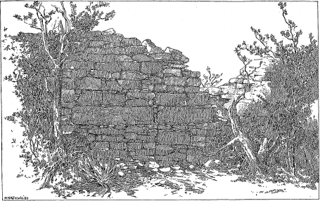
Plate XI. Masonry on the outer wall of the Fire-House, detail.
The well defined outer wall of this cluster to the unaided eye appears to be elliptical, but it will be seen from the plan that the ellipse is somewhat pointed on the side farthest from the cliff. As in other cases of ancient pueblos with curved outlines, the outer wall seems to have been built first, and the inner rooms, while kept as rectangular as possible, were adjusted to this curve. This arrangement often led to a cumulating divergence from radial lines in some of the partitions, which irregularity was taken up in one room, as in this instance, in the space near the gate. The outer wall is uniform in construction so far as preserved. Many irregularities appear, however, in the construction of the inner or partition walls, and some of the rooms show awkward attempts at adjustment to the curve of the outer wall.
The ruin is situated on the very brink of a small canyon, which probably contained a spring at the foot of the cliff close under the ruin site, as the vegetation there has an unusual appearance of freshness, suggesting the close proximity of water to the surface. A steep trail evidently connected the village with the bottom of the canyon. Some of the rocks of the mesa rim were marked by numerous cup-like cavities similar to those seen at Kwaituki, and used in the polishing and forming of stone implements. The type of pueblo here illustrated belonged to a people who relied largely on the architecture for defense, differing in this respect from the spirit of Tusayan architecture generally, where the inaccessible character of the site was the chief dependence.
CHUKUBI.
The ruin called Chukubi by the Tusayan (Pl. XII) is situated on the Middle Mesa, about 3 miles northeast of Mashongnavi. It occupies a promontory above the same broad sandstone ledge that forms such a
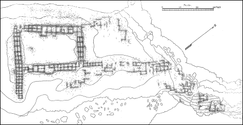
full size Plate XII. Chukubi, plan.
Little masonry now remains on this site, but here and there a fragment aids in defining the general plan of the pueblo. In general form the village was a large rectangle with a line of buildings across its center, dividing it into two unequal courts, and a projecting wing on the west side. As may be seen from the illustration, one end of the ruin forms a clearly defined rectangular court, composed of buildings mostly two rooms deep. Here, as in other ruins of Tusayan, the arrangement about inclosed courts is in contrast with the parallelism of rows, so noticeable a feature in the occupied villages. At the east end of the ruin are several curious excavations. The soft sandstone has been hollowed out to a depth of about 10 inches, in prolongation of the outlines of adjoining rooms. Such excavation to obtain level floors is quite unusual among the pueblo builders; it was practiced to a very small extent, and only where it could be done with little trouble. Any serious inequality of surface was usually incorporated in the construction, as will be noticed at Walpi (Pl. XXIII). Vestiges of masonry indicating detached rooms were seen in each of the courts of the main rectangle.
On the slope of the hill, just above the broad ledge previously described, there is a fine spring, but no trace of a trail connecting it with the pueblo could be found.
This village was advantageously placed for defense, but not to the same degree as Payupki, illustrated in Pl. XIII.
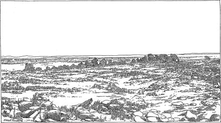
Plate XIV. General view of Payupki.
PAYUPKI.
The ruin called Payupki (Pl. XIII) occupies the summit of a bold promontory south of the trail, from Walpi to Oraibi, and about 6 miles northwest from Mashongnavi. The outer extremity of this promontory is separated from the mesa by a deep notch. The summit is reached from the mesa by way of the neck, as the outer point itself is very abrupt, much of the sandstone ledge being vertical. A bench, 12 or 15 feet below the summit and in places quite broad, encircles the promontory. This bench also breaks off very abruptly.
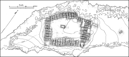
full size Plate XIII. Payupki, plan.
As may be seen from the plan, the village is quite symmetrically laid out and well arranged for defense. It is placed at the mesa end of the promontory cap, and for greater security the second ledge has also been fortified. All along the outer margin of this ledge are the remains of a stone wall, in some places still standing to a height of 1 or 2 feet. This wall appears to have extended originally all along the ledge around three sides of the village. The steepness of the cliff on the remaining side rendered a wall superfluous. On the plain below this promontory, and immediately under the overhanging cliff, are two corrals, and also
In the village proper (Pl. XIV) are two distinctly traceable kivas. One of these, situated in the court, is detached and appears to have been partly underground. The other, located in the southeast end of the village, has also, like the first, apparently been sunk slightly below the surface. There is a jog in the standing wall of this kiva which corresponds to that usually found in the typical Tusayan kivas (see Figs. 22 and 25). On the promontory and east of the village is a single room of more than average length, with a well formed door in the center of one side. This room has every appearance of being contemporary with the rest of the village, but its occurrence in this entirely isolated position is very unusual. Still farther east there is a mass of debris that may have belonged to a cluster of six or eight rooms, or it may possibly be the remains of temporary stone shelters for outlooks over crops, built at a later date than the pueblo. As may be seen from the illustration (Pl. XV), the walls are roughly built of large slabs of sandstone of various sizes. The work is rather better than that of modern Tusayan, but much inferior to that seen in the skillfully laid masonry of the ruins farther north. In many of these walls an occasional sandstone slab of great length is introduced. This peculiarity is probably due to the character of the local material, which is more varied than usual. All of the stone here used is taken from ledges in the immediate vicinity. It is usually light in color and of loose texture, crumbling readily, and subject to rapid decay, particularly when used in walls that are roughly constructed.
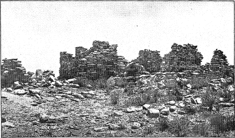
Plate XV. Standing walls of Payupki.
Much of the pottery scattered about this ruin has a very modern appearance, some of it having the characteristic surface finish and color of the Rio Grande ware. A small amount of ancient pottery also occurs here, some of the fragments of black and white ware displaying intricate fret patterns. The quantity of these potsherds is quite small, and they occur mainly in the refuse heaps on the mesa edge.
This ruin combines a clearly defined defensive plan with utilization of one of the most inaccessible sites in the vicinity, producing altogether a combination that would seem to have been impregnable by any of the ordinary methods of Indian warfare.
PLANS AND DESCRIPTIONS OF THE INHABITED VILLAGES.
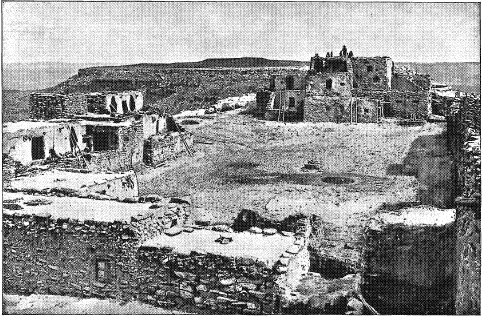
Plate XVII. View of Hano.
HANO.
The village of Hano, or Tewa, is intrusive and does not properly belong to the Tusayan stock, as appears from their own traditions. It is somewhat loosely planned (Pl. XVI) and extends nearly across the mesa tongue, which is here quite narrow, and in general there is no appreciable difference between the arrangement here followed and that of the other villages. One portion of the village, however, designated as House No. 5 on the plan, differs somewhat from the typical arrangement in long irregular rows, and approaches the pyramidal form found among the more eastern pueblos, notably at Taos and in portions of Zuñi. As has been seen, tradition tells us that this site was taken up by the Tewa at a late date and subsequent to the Spanish conquest; but some houses, formerly belonging to the Asa people, formed a nucleus about which the Tewa village of Hano was constructed. The pyramidal house occupied by the old governor, is said to have been built over such remains of earlier houses.
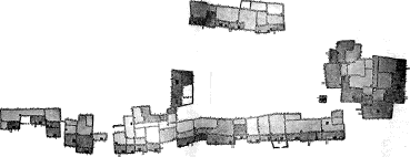
full size Plate XVI. Plan of Hano (rotated).
The largest building in the village appears to have been added to from time to time as necessity for additional space arose, resulting in much the same arrangement as that characterizing most of the Tusayan houses, viz, a long, irregular row, not more than three stories high at any point. The small range marked No. 4 on the plan contains a section three stories high, as does the long row and also the pyramidal cluster above referred to. (Pl. XVII.)
The kivas are two in number, one situated within the village and the other occupying a position in the margin of the mesa. These ceremonial chambers, so far as observed, appear to be much like those in the other villages, both in external and internal arrangement.
Within the last few years the horse trail that afforded access to Hano and Sichumovi has been converted into a wagon road, and during the progress of this work, under the supervision of an American, considerable blasting was done. Among other changes the marginal kiva, which was nearly in line with the proposed improvements, was removed. This was done despite the protest of the older men, and their predictions of dire calamity sure to follow such sacrilege. A new site was selected close by and the newly acquired knowledge of the use of powder was utilized in blasting out the excavation for this subterranean chamber. It is altogether probable that the sites of all former kivas were largely determined by accident, these rooms being built at points where natural fissures or open spaces in the broken mesa edge furnished a suitable depression or cavity. The builders were not capable of working the stone to any great extent, and their operations were probably limited to trimming out such natural excavations and in part lining them with masonry.
There is a very noticeable scarcity of roof-holes, aside from those of the first terrace. As a rule the first terrace has no external openings
At several points ruined walls are seen, remains of abandoned rooms that have fallen into decay. Occasionally a rough, buttress-like projection from a wall is the only vestige of a room or a cluster of rooms, all traces on the ground having been obliterated.
The mesa summit, that forms the site of this village, is nearly level, with very little earth on its surface. A thin accumulation of soil and rubbish lightly covers the inner court, but outside, along the face of the long row, the bare rock is exposed continuously. Where the rooms have been abandoned and the walls have fallen, the stones have all been utilized in later constructions, leaving no vestige of the former wall on the rocky site, as the stones of the masonry have always been set upon the surface of the rock, with no excavation or preparation of footings of any kind.
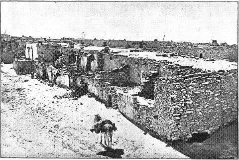
Plate XIX. View of Sichumovi.
SICHUMOVI.
According to traditional accounts this village was founded at a more recent date than Walpi. It has, however, undergone many changes since its first establishment.
The principal building is a long irregular row, similar to that of Hano (Pl. XVIII). A portion of an L-shaped cluster west of this row, and a small row near it parallel to the main building, form a rude approximation to the inclosed court arrangement. The terracing here, however, is not always on the court side, whereas in ancient examples such arrangement was an essential defensive feature, as the court furnished the only approach to upper terraces. In all of these villages there is a noticeable tendency to face the rows eastward instead of toward the court. The motive of such uniformity of direction in the houses must have been strong, to counteract the tendency to adhere to the ancient arrangement. The two kivas of the village are built side by side, in contact, probably on account of the presence at this point of a favorable fissure or depression in the mesa surface.
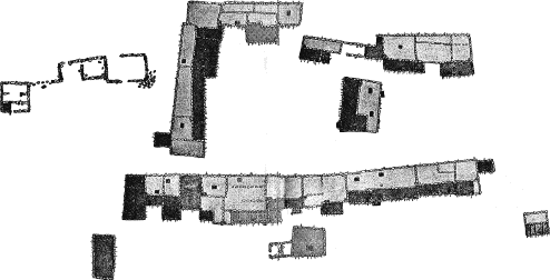
full size Plate XVIII. Plan of Sichumovi.
On the south side of the village are the remains of two small clusters of rooms that apparently have been abandoned a long time. A portion of a room still bounded by standing walls has been utilized as a corral for burros (Pl. XIX).
At this village are three small detached houses, each composed of but a single room, a feature not at all in keeping with the spirit of pueblo construction. In this instance it is probably due to the selection of the village as the residence of whites connected with the agency or school. Of these single-room houses, one, near the south end of the long row, was being built by an American, who was living in another such house near the middle of this row. The third house, although fairly well preserved at the time of the survey, was abandoned and falling into ruin. Adjoining the middle one of these three buildings on
This village, though limited to two stories in height, has, like the others of the first mesa, a number of roof holes or trapdoors in the upper story, an approach to the Zuñi practice. This feature among the Tusayan villages is probably due to intercourse with the more eastern pueblos, for it seems to occur chiefly among those having such communication most frequently. Its presence is probably the result simply of borrowing a convenient feature from those who invented it to meet a necessity. The conditions under which the houses were built have hardly been such as to stimulate the Tusayan to the invention of such a device. The uniform height of the second-story roofs seen in this village, constituting an almost unbroken level, is a rather exceptional feature in pueblo architecture. Only one depression occurs in the whole length of the main row.
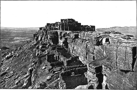
Plate XXI. View of Walpi.
WALPI.
Of all the pueblos, occupied or in ruins, within the provinces of Tusayan and Cibola, Walpi exhibits the widest departure from the typical pueblo arrangement (Pl. XX).
The carelessness characteristic of Tusayan architecture seems to have reached its culmination here. The confused arrangement of the rooms, mainly due to the irregularities of the site, contrasts with the work at some of the other villages, and bears no comparison with much of the ancient work. The rooms seem to have been clustered together with very little regard to symmetry, and right angles are very unusual. (See Fig. 8.)
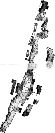
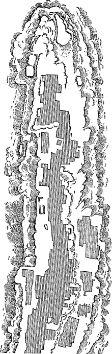
full size Plate XX. Plan of Walpi. Fig. 8. Topography of the site of Walpi.
The general plan of the village of to-day confirms the traditional accounts of its foundation. According to these its growth was gradual, beginning with a few small clusters, which were added to from time to time as the inhabitants of the lower site upon the spur of the mesa, where the mission was established, moved up and joined the pioneers on the summit. It is probable that some small rooms or clusters were built on this conspicuous promontory soon after the first occupation of this region, on account of its exceptionally favorable position as an outlook over the fields (Pl. XXI).
Though the peculiar conformation of the site on which the village has been built has produced an unusual irregularity of arrangement, yet even here an imperfect example of the typical inclosed court may be found, at one point containing the principal kiva or ceremonial chamber of the village. It is probable that the accidental occurrence of a suitable break or depression in the mesa top determined the position of this kiva at an early date and that the first buildings clustered about this point.
A unique feature in this kiva is its connection with a second subterranean chamber, reached from the kiva through an ordinary doorway. The depression used for the kiva site must have been either larger than was needed or of such form that it could not be thrown into one rectangular Pl. XXII. Southeast from the kiva there is a large mass of rocks projecting above the general level, which has been incorporated into a cluster of dwelling rooms. Its character and relation to the architecture may be seen in Pl. XXIII. So irregular a site was not likely to be built upon until most of the available level surface had been taken up, for even in masonry of much higher development than can be found in Tusayan the builders, unable to overcome such obstacles as a large mass of protruding rock, have accommodated their buildings to such irregularities. This is very noticeable in the center cluster of Mummy Cave (in Canyon del Muerto, Arizona), where a large mass of sandstone, fallen from the roof of the rocky niche in which the houses were built, has been incorporated into the house cluster. Between this and another kiva to the north the mesa top is nearly level. The latter kiva is Pl. XXIV).
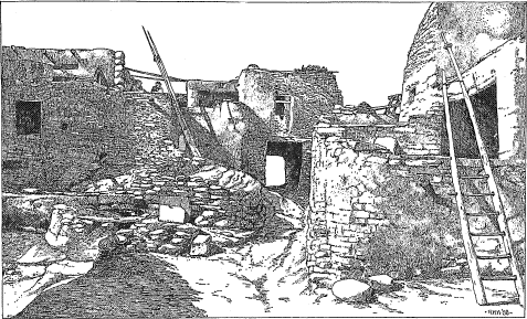
Plate XXII. South passageway of Walpi.
A short distance farther toward the north occur a group of three more kivas. These are on the very brink of the mesa, and have been built in recesses in the crowning ledge of sandstone of such size that they could conveniently be walled up on the outside, the outer surface of rude walls being continuous with the precipitous rock face of the mesa.
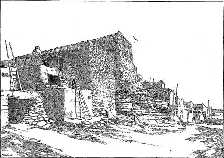
Plate XXIII. Houses built over irregular sites, Walpi.
The positions of all these ceremonial chambers seem to correspond with exceptionally rough and broken portions of the mesa top, showing that their location in relation to the dwelling clusters was due largely to accident and does not possess the significance that position does in many ancient pueblos built on level and unencumbered sites, where the adjustment was not controlled by the character of the surface.
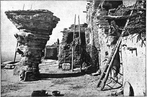
Plate XXIV. Dance rock and kiva, Walpi.
The Walpi promontory is so abrupt and difficult of access that there is no trail by which horses can be brought to the village without passing through Hano and Sichumovi, traversing the whole length of the mesa tongue, and crossing a rough break or depression in the mesa summit close to the village. Several foot trails give access to the village, partly over the nearly perpendicular faces of rock. All of these have required to be artificially improved in order to render them practicable. Plate XXV, from a photograph, illustrates one of these trails, which, a portion of the way, leads up between a huge detached slab of sandstone and the face of the mesa. It will be seen that the trail at this point consists to a large extent of stone steps that have been built in. At the top of the flight of steps where the trail to the mesa summit turns to the right the solid sandstone has been pecked out so as to furnish a series of footholes, or steps, with no projection or hold of any kind alongside. There are several trails on the west side of the mesa leading down both from Walpi and Sichúmovi to a spring below, which are quite as abrupt as the example illustrated. All the water used in these villages, except such as is caught during showers in the basin-like water pockets of the mesa top, is laboriously brought up these trails in large earthenware canteens slung over the backs of the women.
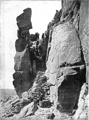
Plate XXV. Foot trail to Walpi.
Supplies of every kind, provisions, harvested crops, fuel, etc., are brought up these steep trails, and often from a distance of several miles, yet these conservative people tenaciously cling to the inconvenient situation selected by their fathers long after the necessity for so doing has passed away. At present no argument of convenience or comfort seems sufficient to induce them to abandon their homes on the rocky heights and build near the water supply and the fields on which they depend for subsistence.
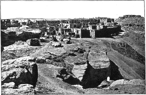
Plate XXVII. Mashongnavi with Shupaulovi in distance.
MASHONGNAVI.
Mashongnavi, situated on the summit of a rocky knoll, is a compact though irregular village, and the manner in which it conforms to the general outline of the available ground is shown on the plan. Convenience of access to the fields on the east and to the other villages probably prompted the first occupation of the east end of this rocky butte (Pl. XXVI).
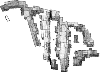
full size Plate XXVI. Mashongnavi, plan.
In Mashongnavi of to-day the eastern portion of the village forms a more decided court than do the other portions. The completeness in itself of this eastern end of the pueblo, in connection with the form of the adjoining rows, strongly suggests that this was the first portion of the pueblo built, although examination of the masonry and construction furnish but imperfect data as to the relative age of different portions of the village. One uniform gray tint, with only slight local variations in character and finish of masonry, imparts a monotonous effect of antiquity to the whole mass of dwellings. Here and there, at rare intervals, is seen a wall that has been newly plastered; but, ordinarily, masonry of 10 years’ age looks nearly as old as that built 200 years earlier. Another feature that suggests the greater antiquity of the eastern court of the pueblo is the presence and manner of occurrence here of the kiva. The old builders may have been influenced to some extent in their choice of site by the presence of a favorable depression for the construction of a kiva, though this particular example of the ceremonial room is only partly subterranean. The other kivas are almost or quite below the ground level. Although a favorable depression might readily occur on the summit of the knoll, a deep cavity, suitable for the construction of the subterranean kiva, would not be likely to occur at such a distance from the margin of the sandstone ledge. The builders evidently preferred to adopt such half-way measures with their first kiva in order to Fig. 9. Mashongnavi and Shupaulovi from Shumopavi. Pl. XXVII shows that the site of this pueblo, as well as that of its neighbor, Shupaulovi, was not particularly defensible, and that this fact would have weight in securing adherence in the first portion Pl. XVIII. This process continued until the last cluster nearly filled the available site and a wing was thrown out corresponding to a tongue or spur of the knoll upon which it was built. Naturally the westernmost or newer portions show more clearly Pl. XXVIII). This village furnishes the most striking example in the whole group of the manner in which a pueblo was gradually enlarged as increasing population demanded more space. Such additions were often carried out on a definite plan, although the results in Tusayan fall far short of the symmetry that characterizes many ruined pueblos in New Mexico and Arizona.
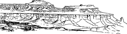
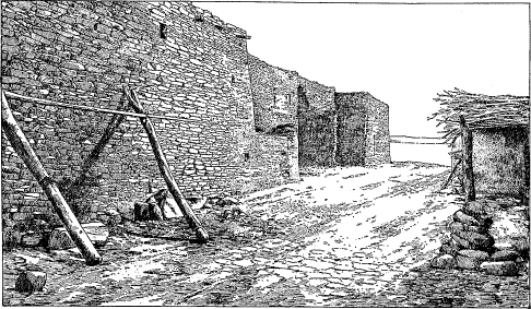
Plate XXVIII. Back wall of a Mashongnavi house-row.
A few of these ancient examples, especially some of the smaller ruins of the Chaco group, are so symmetrical in their arrangement that they seem to be the result of a single effort to carry out a clearly fixed plan. By far the largest number of pueblos, however, built among the southwest tablelands, if occupied for any length of time, must have been subject to irregular enlargement. In some ancient examples, such additions to the first plan undoubtedly took place without marring the general symmetry. This was the case at Pueblo Bonito, on the Chaco, where the symmetrical and even curve of the exterior defensive wall, which was at least four stories high, remained unbroken, while the large inclosed court was encroached upon by wings added to the inner terraces. These additions comfortably provided for a very large increase of population after the first building of the pueblo, without changing its exterior appearance.
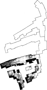
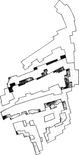
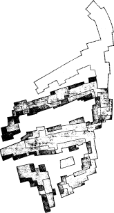
In order to make clearer this order of growth in Mashongnavi, a series of skeleton diagrams is added in Figs. 10, 11, and 12, giving the outlines of the pueblo at various supposed periods in the course of its enlargement. The larger plan of the village (Pl. XXVI) serves as a key to these terrace outlines.
full size full size full size
Figs. 10, 11, 12. Diagrams showing growth of Mashongnavi.
The first diagram illustrates the supposed original cluster of the east court (Fig. 10), the lines of which can be traced on the larger plan, and it includes the long, nearly straight line that marks the western edge of the third story. This diagram shows also, in dotted lines, the general plan that may have guided the first additions to the west. The second diagram (Fig. 11) renders all the above material in full tint, again indicating further additions by dotted lines, and so on. (Fig. 12.) The portions of a terrace, which face westward in the newer courts of the pueblo, illustrated in Pl. XXIX, were probably built after the western row, completing the inclosure, and were far enough advanced to indicate definitely an inclosed court, upon which the dwelling rooms faced.
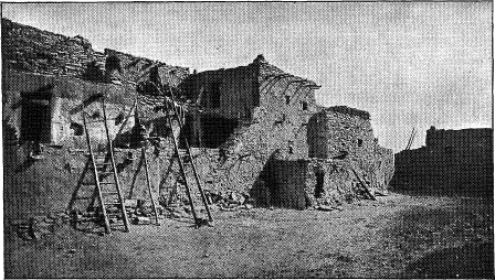
Plate XXIX. West side of a principal row in Mashongnavi.
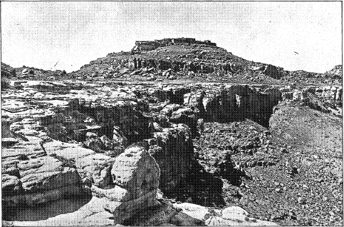
Plate XXXI. View of Shupaulovi.
SHUPAULOVI.
This village, by far the smallest pueblo of the Tusayan group, illustrates a simple and direct use of the principle of the inclosed court. The plan (Pl. XXX) shows that the outer walls are scarcely broken by terraces, and nearly all the dwelling apartments open inwards upon the inclosure, in this respect closely following the previously described ancient type, although widely differing from it in the irregular disposition of the rooms. (Pl. XXXI) A comparison with the first of the series of diagrams illustrating the growth of Mashóngnavi, will show how similar the villages may have been at one stage, and how suitable a nucleus for a large pueblo this village would prove did space and character of the site permit. Most of the available summit of the rocky knoll has already been covered, as will be seen from the topographic sketch of the site (Fig. 13). The plan shows also that some efforts at extension of the pueblo have been made, but the houses outside of the main cluster have been abandoned, and are rapidly going to ruin. Several small rooms occur on the outer faces of the rows, but it can be readily seen that they do not form a part of the original plan but were added to an already complete structure.
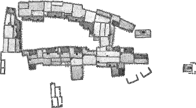
full size Plate XXX. Plan of Shupaulovi.
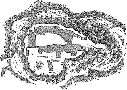
Fig. 13. Topography of the site of Shupaulovi.
In the inclosed court of this pueblo occurs a small box-like stone inclosure, covered with a large slab, which is used as a sort of shrine or depository for the sacred plume sticks and other ceremonial offerings.
The plan of this small village shows three covered passageways similar to those noted in Walpi on the first mesa, though their presence here can not be ascribed to the same motives that impelled the Walpi to build in this way; for the densely crowded site occupied by the latter compelled them to resort to this expedient. One of these is illustrated in Pl. XXXII. Its presence may be due in this instance to a determination to adhere to the protected court while seeking to secure convenient means of access to the inclosed area. It is remarkable that this, the smallest of the group, should contain this feature.
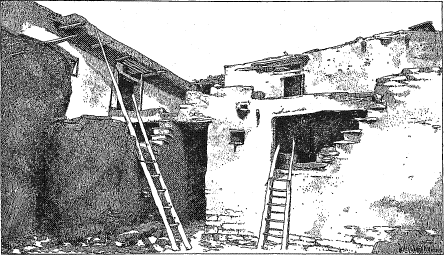
Plate XXXII. A covered passageway of Shupaulovi.
This village has but two kivas, one of which is on the rocky summit near the houses and the other on the lower ground near the foot of the trail that leads to the village. The upper kiva is nearly subterranean, the roof being but a little above the ground on the side toward the village, but as the rocky site slopes away a portion of side wall is exposed. This was roughly built, with no attempt to impart finish to its outer face, either by careful laying of the masonry or by plastering. Pl. XXXIII illustrates this kiva in connection with the southeastern portion of the village. The plan shows how the prolongation of the side rows of the village forms a suggestion of a second court. Its development into any such feature as the secondary or additional courts of Mashóngnavi was prohibited by the restricted site.
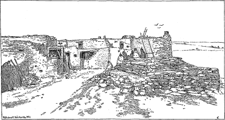
Plate XXXIII. The chief kiva of Shupaulovi.
As in other villages of this group, the desire to adhere to the subterranean form of ceremonial chamber outweighed the inducement to place it within the village, or, in the case of the second kiva, even of placing it on the same level as the houses, which are 30 feet above it with an abrupt trail between them. It is curious and instructive to see a room, the use of which is so intimately connected with the inner life of the village, placed in such a comparatively remote and inaccessible position through an intensely conservative adherence to ancient practice requiring this chamber to be depressed.
The general view of the village given in Pl. XXXI strikingly illustrates the blending of the rectangular forms of the architecture with the angular and sharply defined fractures of the surrounding rock. This close correspondence in form between the architecture and its immediate surroundings is greatly heightened by the similarity in color. Mr. Stephen has called attention to a similar effect on the western side of Walpi and its adjacent mesa edge, which he thought indicates a distinct effort at concealment on the part of the builders, by blending the architecture with the surroundings. This similarity of effect is often accidental, and due to the fact that the materials of the houses and of the mesas on which they are built are identical. Even in the case of Walpi, cited by Mr. Stephen, where the buildings come to the very mesa edge, and in their vertical lines appear to carry out the effect of
Such correspondence with the surroundings, which forms a striking feature of many primitive types of construction where intention of concealment had no part, is doubtless mainly due to the use of the most available material, although the expression of a type of construction that has prevailed for ages in one locality would perhaps be somewhat influenced by constantly recurring forms in its environment. In the system of building under consideration, such influence would, however, be a very minute fraction in the sum of factors producing the type and could never account for such examples of special and detailed correspondence as the cases cited, nor could it have any weight in developing a rectangular type of architecture.
In the development of primitive arts the advances are slow and laborious, and are produced by adding small increments to current knowledge. So vague and undefined an influence as that exerted by the larger forms of surrounding nature are seldom recognized and acknowledged by the artisan; on the contrary, experiments, resulting in improvement, are largely prompted by practical requirements. Particularly is this the case in the art of house-building.
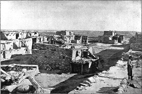
Plate XXXV. View of Shumopavi.
SHUMOPAVI.
This village, although not so isolated as Oraibi, has no near neighbors and is little visited by whites or Indians. The inhabitants are rarely seen at the trading post to which the others resort, and they seem to be pretty well off and independent as compared with their neighbors of the other villages (Pl. XXXIV). The houses and courts are in keeping with the general character of the people and exhibit a degree of neatness and thrift that contrasts sharply with the tumble-down appearance of some of the other villages, especially those of the Middle Mesa and Oraibi. There is a general air of newness about the place, though it is questionable whether the architecture is more recent than that of the other villages of Tusayan. This effect is partly due to the custom of frequently renewing the coating of mud plaster. In most of the villages little care is taken to repair the houses until the owner feels that to postpone such action longer would endanger its stability. Many of the illustrations in this chapter indicate the proportion of rough masonry usually exposed in the walls. At Shumopavi (Pl. XXXV), however, most of the walls are smoothly plastered. In this respect they resemble Zuñi and the eastern pueblos, where but little naked masonry can be seen. Another feature that adds to the effect of neatness and finish in this village is the frequent use of a whitewash of
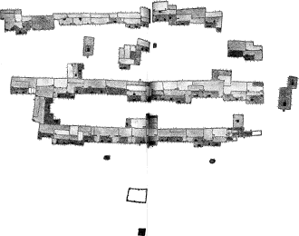
full size Plate XXXIV. Plan of Shumopavi.
Shumopavi, compared with the other villages, shows less evidence of having been built on the open court idea, as the partial inclosures assume such elongated forms in the direction of the long, straight rows of the rooms; yet examination shows that the idea was present to a slight extent.
At the southeast corner of the pueblo there is a very marked approach to the open court, though it is quite evident that the easternmost row has its back to the court, and that the few rooms that face the other way are later additions. In fact, the plan of the village and the distribution of the terraces seem to indicate that the first construction consisted only of a single row facing nearly east, and was not an inclosed court, and that a further addition to the pueblo assumed nearly the same form, with its face or terraced side toward the back of the first row only partly adapting itself by the addition of a few small rooms later, to the court arrangement, the same operation being continued, but in a form not so clearly defined, still farther toward the west.
The second court is not defined on the west by such a distinct row as the others, and the smaller clusters that to some extent break the long, straight arrangement bring about an approximation to a court, though here again the terraces only partly face it, the eastern side being bounded by the long exterior wall of the middle row, two and three stories high, and almost unbroken throughout its entire length of 400 feet. The broken character of the small western row, in conjunction with the clusters near it, imparts a distinct effect to the plan of this portion, differentiating it in character from the masses of houses formed by the other two rows. The latter are connected at their southern end by a short cross row which converts this portion of the village practically into a single large house. Two covered passageways, however, which are designated on the plan, give access to the southeast portion of the court. This portion is partly separated from the north half of the inclosure by encroaching groups of rooms. This partial division of the original narrow and long court appears to be of later date.
The kivas are four in number, of which but one is within the village. The latter occupies a partly inclosed position in the southwest portion, and probably owes its place to some local facility for building a kiva on this spot in the nature of a depression in the mesa summit; but even Fig. 14. The remaining three kivas are more distinctly subterranean, and in order to obtain a suitable site one of these was located at a distance of more than 200 feet from the village, toward the mesa edge on the east. The other two are built very close together, apparently in contact, just beyond the northern extremity of the village. One of these is about 3 feet above the surface at one corner, but nearly on a level with the ground at its western side where it adjoins its neighbor. These two kivas are illustrated in Pl. LXXXVIII and Fig. 21.
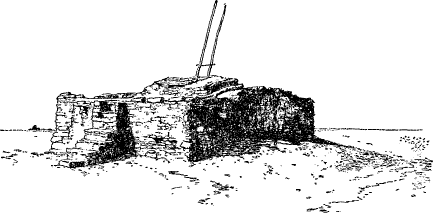
Fig. 14. Court kiva of Shumopavi.
Here again we find that the ceremonial chamber that forms so important a feature among these people, occupies no fixed relation to the dwellings, and its location is largely a matter of accident, a site that would admit of the partial excavation or sinking of the chamber below the surface being the main requisite. The northwest court contains another of the small inclosed shrines already described as occurring at Shupaulovi and elsewhere.
The stonework of this village also possesses a somewhat distinctive character. Exposed masonry, though comparatively rare in this well-plastered pueblo, shows that stones of suitable fracture were selected and that they were more carefully laid than in the other villages. In places the masonry bears a close resemblance to some of the ancient work, where the spaces between the longer tablets of stone were carefully chinked with small bits of stone, bringing the whole wall to a uniform face, and is much in advance of the ordinary slovenly methods of construction followed in Tusayan.
Shumopavi is the successor of an older village of that name, one of the cities of the ancient Tusayan visited by a detachment of Coronado’s expedition in 1540. The ruins of that village still exist, and they formerly contained vestiges of the old church and mission buildings established
ORAIBI.
This is one of the largest modern pueblos, and contains nearly half the population of Tusayan; yet its great size has not materially affected the arrangement of the dwellings. The general plan (see Pl. XXXVI), simply shows an unusually large collection of typical Tusayan house-rows, with the general tendency to face eastward displayed in the other villages of the group. There is a remarkable uniformity in the direction of the rows, but there are no indications of the order in which the successive additions to the village were made, such as were found at Mashóngnavi.
The white strip along the middle of this plan represents the area near a tight fold in the printed original. The width of the unreadable area is conjectural.
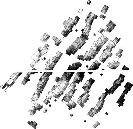
full size Plate XXXVI. Oraibi, plan.
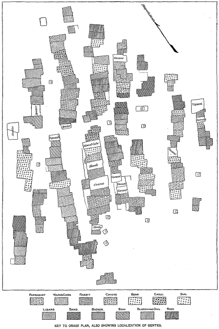
Plate XXXVII. Key to the Oraibi plan, also showing localization of gentes.
The clusters of rooms do not surpass the average dimensions of those in the smaller villages. In five of the clusters in Oraibi a height of four stories is reached by a few rooms; a height seen also in Walpi.
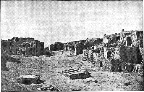
Plate XXXVIII. A court of Oraibi.
At several points in Oraibi, notably on the west side of cluster No. 7, may be seen what appears to be low terraces faced with rough masonry. The same thing is also seen at Walpi, on the west side of the northernmost cluster. This effect is produced by the gradual filling in of abandoned and broken-down marginal houses, with fallen masonry and drifted sand. The appearance is that of intentional construction, as may be seen in Pl. XXXIX.
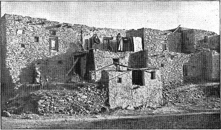
Plate XXXIX. Masonry terraces of Oraibi.
The rarity of covered passageways in this village is noteworthy, and emphasizes the marked difference in the character of the Tusayan and Zuñi ground plans. The close crowding of rooms in the latter has made a feature of the covered way, which in the scattered plan of Oraibi is rarely called for. When found it does not seem an outgrowth of the same conditions that led to its adoption in Zuñi. A glance at the plans will show how different has been the effect of the immediate environment in the two cases. In Zuñi, built on a very slight knoll in the open plain, the absence of a defensive site has produced unusual development of the defensive features of the architecture, and the result is a remarkably dense clustering of the dwellings. At Tusayan, on the other hand, the largest village of the group does not differ in character from the smallest. Occupation of a defensive site has there, in a measure taken the place of a special defensive arrangement, or close clustering of rooms. Oraibi is laid out quite as openly as any other of the group, and as additions to its size have from time to time been made the builders have, in the absence of the defensive motive for crowding the rows or groups into large clusters, simply followed the usual arrangement. The crowding that brought about the use of the covered way was due in Walpi to restricted site, as nearly all the available summit of its rocky promontory has been covered with buildings. In Zuñi, on
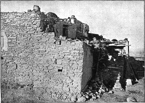
Plate XL. Oraibi house row, showing court side.
A further contrast between the general plans of Oraibi and Zuñi is afforded in the different manner in which the roof openings have been employed in the two cases. The plan of Zuñi, Pl. LXXVI, shows great numbers of small openings, nearly all of which are intended exclusively for the admission of light, a few only being provided with ladders. In Oraibi, on the other hand, there are only seventeen roof openings above the first terrace, and of these not more than half are intended for the admission of light. The device is correspondingly rare in other villages of the group, particularly in those west of the first mesa. In Mashóngnavi the restricted use of the roof openings is particularly noticeable; they all are of the same type as those used for access to first terrace rooms. There is but one roof opening in a second story. An examination of the plan, Pl. XXX, will show that in Shupaúlovi but two such openings occur above the first terrace, and in the large village of Shumopavi, Pl. XXXIV, only about eight. None of the smaller villages can be fairly compared with Zuñi in the employment of this feature, but in Oraibi we should expect to find its use much more general, were it not for the fact that the defensive site has taken the place of the close clustering of rooms seen in the exposed village of Zuñi, and, in consequence, the devices for the admission of light still adhere to the more primitive arrangement (Pls. XL and XLI).
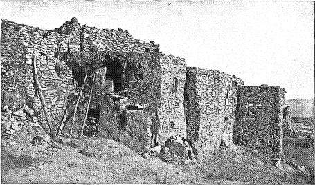
Plate XLI. Back of Oraibi house row.
The highest type of pueblo construction, embodied in the large communal fortress houses of the valleys, could have developed only as the builders learned to rely for protection more upon their architecture and less upon the sites occupied. So long as the sites furnished a large proportion of the defensive efficiency of a village, the invention of the builders was not stimulated to substitute artificial for natural advantages. Change of location and consequent development must frequently have taken place owing to the extreme inconvenience of defensive sites to the sources of subsistence.
The builders of large valley pueblos must frequently have been forced to resort hastily to defensive sites on finding that the valley towns were unfitted to withstand attack. This seems to have been the case with the Tusayan; but that the Zuñi have adhered to their valley pueblo through great difficulties is clearly attested by the internal evidence of the architecture itself, even were other testimony altogether wanting.
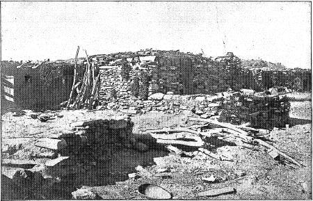
Plate XLIV. Moen-kopi.
MOEN-KOPI.
About 50 miles west from Oraibi is a small settlement used by a few families from Oraibi during the farming season, known as Moen-kopi. (Pl. XLIII). The present village is comparatively recent, but, as is the case with many others, it has been built over the remains of an older settlement. It is said to have been founded within the memory of
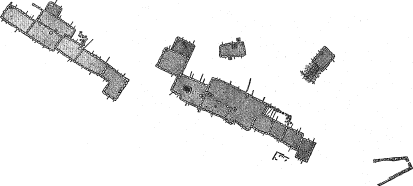
full size Plate XLIII. Plan of Moen-kopi (rotated).
The site would probably have attracted a much larger number of settlers, had it not been so remote from the main pueblos of the province, as in many respects it far surpasses any of the present village sites. A large area of fertile soil can be conveniently irrigated from copious springs in the side of a small branch of the Moen-kopi wash. The village occupies a low, rounded knoll at the junction of this branch with the main wash, which on the opposite or southern side is quite precipitous. The gradual encroachments of the Mormons for the last twenty years have had some effect in keeping the Tusayan from more fully utilizing the advantages of this site (Pl. XLII).
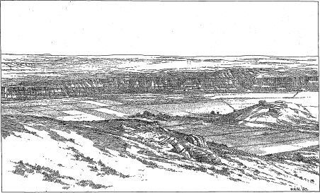
Plate XLII. The site of Moen-kopi.
Moen-kopi is built in two irregular rows of one-story houses. There are also two detached single rooms in the village—one of them built for a kiva, though apparently not in use at the time of our survey, and the other a small room with its principal door facing an adjoining row. The arrangement is about the same that prevails in the other villages, the rows having distinct back walls of rude masonry.
Rough stone work predominates also in the fronts of the houses, though it is occasionally brought to a fair degree of finish. Some adobe work is incorporated in the masonry, and at one point a new and still unroofed room was seen built of adobe bricks on a stone foundation about a foot high. There is but little adobe masonry, however, in Tusayan. Its use in this case is probably due to Mormon influence.
Moen-kopi was the headquarters of a large business enterprise of the Mormons a number of years ago. They attempted to concentrate the product of the Navajo wool trade at this point and to establish here a completely appointed woolen mill. Water was brought from a series of reservoirs built in a small valley several miles away, and was conducted to a point on the Moen-kopi knoll, near the end of the south row of houses, where the ditch terminated in a solidly constructed box of masonry. From this in turn the water was delivered through a large pipe to a turbine wheel, which furnished the motive power for the works. The ditch and masonry are shown on the ground plan of the village (Pl. XLIII). This mill was a large stone building, and no expense was spared in fitting it up with the most complete machinery. At the time of our visit the whole establishment had been abandoned for some years and was rapidly going to decay. The frames had been torn from the windows, and both the floor of the building and the ground in its vicinity were strewn with fragments of expensive machinery, broken cog-wheels, shafts, etc. This building is shown in Pl. XLV, and may serve as an illustration of the contrast between Tusayan masonry and modern stonemason’s work carried out with the same material. The comparison, however, is not entirely fair, as applied to the pueblo builders in general, as the Tusayan mason is unusually careless in his work. Many old examples are seen in which the finish of the walls compares very
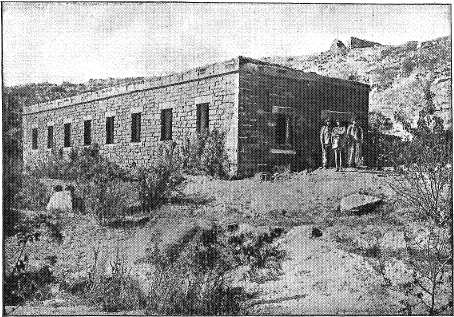
Plate XLV. The Mormon mill at Moen-kopi.