APPENDIX G.
Ernest Georg Ravenstein translation
EARLY MAPS ILLUSTRATING VASCO DA GAMA’S FIRST VOYAGE.
It must ever be matter for regret that none of the sailing charts prepared by Vasco da Gama’s pilots should have reached us. In tracing the progress of his expedition with the aid of charts we are consequently dependent upon compilations which, although contemporary, embody also materials brought home by other navigators.
One great drawback of all the charts available for our purpose is their small scale.457 This compelled their compilers to make a selection from the names which they found inserted upon the larger charts at their disposal, and this selection may not always have been a judicious one. The compilation of a map from discordant materials presents difficulties even in the present day, and these difficulties were much greater at a time when the compiler had not at his command trustworthy observations for latitude which would have enabled him to check the positions of intermediate places, and bring into agreement the records brought home by successive explorers. As an instance, we may mention that in the five maps which we shall bring more fully under notice, the latitude assigned to the Cape of Good Hope varies between 29° and 34° S., its true position being 34° 22´ S. As to longitudes, they had to be determined by dead reckoning, and it need not therefore surprise us if, on the maps referred to, the Cape is placed from 3° 50´ to 10° 20´ too far to the eastward. Nay, this near approach to the truth, in at least one instance, compels our recognition of the skill of the men who piloted the first ships around that long-sought Cabo desejado.
Another difficulty arises from the crabbed characters employed by the map draughtsmen of the early part of the sixteenth century: a difficulty all the more serious when these illegible characters had to be reproduced by Italians having no knowledge of the language of the documents they used, or the meaning of the uncouth names which they were called upon to copy. It is one of the great merits of Mercator to have caused these characters to be banished from the maps of his countrymen; but a second Mercator is still wanted to do the same good work for their printed books.
I now proceed to a consideration of the charts which illustrate more especially Vasco da Gama’s first voyage.
The first of these charts is by Henricus Martellus Germanus. It is one of many in a MS., Insularium illustratum, now in the British Museum (Add. MS. 15760). It is a map of the world, very roughly drawn and without a scale, and is dated 1489, that is almost immediately after the return of Dias in the December of the preceding year. The author, no doubt, was an Italian, and other maps by his skilful hand are known to exist.458 Unfortunately for our purpose, the coast beyond the Cape is very incorrectly drawn, and there are but six names, viz., Golfo dentro delle serre (False Bay), Rio della vacche (Gouritz), Cavo dalhado (talhado, Seal Point), Golfo de Pastori (St. Francis Bay), Padrom de S. George (instead of Gregorio), and Ilha de fonte (instead of infante).459
The first map illustrating, or rather attempting to illustrate, Vasco da Gama’s voyage is that compiled by Juan de la Cosa, the famous pilot of Columbus, in 1500. The author was fairly well informed of the discoveries made by his own countrymen, but knew apparently but little about those of the Portuguese. Thus, although Vicente Yanez Pinzon only returned to Spain on September 30th, 1500, the coast explored by him to the westward of the Rostro hermoso (the Cabo de Agostinho of the Portuguese) is laid down properly; whilst Santa Cruz, discovered by Cabral in April 1500, is incorrectly indicated,460 although Gaspar de Lemos, whom Cabral sent back with the news of his discovery, arrived in Portugal three months before the Spanish navigator. As to two groups of islands in the southern Atlantic, namely, “thebas, yslas tibras etiopicas yn mare oceanum austral” (lat 1° 40´ S.), and “Y. tausens, ylas tausens montises etiopicus oceanas” (lat. 15° S.), they seem to be quite imaginary, and I only refer to them here because they kept their place on later maps, and might be mistaken for the islands discovered by João da Nova in 1501-2. Of the results of Vasco da Gama’s expedition Juan de la Cosa must have been very ill-informed; among the many uncouth and incomprehensible names inserted by him along the Eastern coast of Africa there is not one which can be traced to Gama. Not even such places as Sofala, Quiloa, Moçambique and Mombaça can be identified, whilst Zanzibar and Madagascar lie far out in the Indian Ocean.461
The coastline of the Indian Ocean is Ptolemaic; there is no hint at the peninsular shape of India, the map being in that respect inferior to that of the Catalan, more than a hundred years older, and the only indication of Vasco da Gama’s visit to these seas is the name “Calicut”, placed on the south coast of Caramania (Kerman), with a legend to the east of it: “tierra descubierto por el rey dom Manuel rey de Portugal.”462
Our next chart shows a great advance upon the preceding. It was purchased at a sale in London, and is now the property of Dr. Hamy, who published a description of it, with facsimiles, in his Études historiques et géographiques, Paris, 1896. The author is not known. His chart places on record the discoveries made by Vicente Yanez Pinzon, Cabral, Sancho de Toar, and Cortereal, and by the expedition which King Manuel sent to Brazil in 1501, and which returned at the beginning of September, 1502.463 This expedition, which was accompanied by Vespucci, explored the American coast as far as the Rio de Cananea, in lat. 25° 45´ S. The author knows nothing of the discoveries of João da Nova, who returned to Lisbon on September 11th, 1502. We may therefore safely date his map “1502”, as is done by Dr. Hamy.
One curious feature of this map is its double equator: that for the western half of the map being the ‘new’ equator, to which the recent discoveries of the Spaniards and Portuguese are to be referred, whilst that for the east lies four degrees to the north of the former, and is taken from Ptolemy. Indeed, the outline of the Indian Ocean is Ptolemy’s, and so is the nomenclature, with a few exceptions to be noticed presently. In the south-east, however, the author has broken through Ptolemy’s encircling barrier, and has thus opened a way from the Indicum mare to an outer ocean where room has been found for Seilam, Iava and far Quinsai. The eastern edge of his Oekumene lies 205° to the east of Lisbon (196° E. of Greenwich).464 The only original features within the Indian Ocean are a peninsular India, which is made to project from Ptolemy’s old coastline to the west of Taprobana, with a town, “Colochuti”, and the islands of Madagascar and Tangibar lying far out at sea in lat. 20° S. The only other modern name within this wide area is “Malacha”, which is placed in the Aurea Chersonesus.
The nomenclature along the African coast is fairly full, and evidently taken from original sources,465 but the spelling is so corrupt, and the letters are frequently so illegible, that I failed to make out many of the names, although I had that portion of the map which specially interested me enlarged from Dr. Hamy’s facsimile by photography. An examination of the copy, which I give, will show that the drawing of the coast-line leaves very much to be desired.
A very great advance upon the preceding is shown by a chart which Alberto Cantino, the correspondent of Hercules d’Este, Duke of Ferrara, caused to be specially designed for his patron, at Lisbon, and for which he paid twelve golden ducats. There can be no doubt about the date of this map. It was begun after Cortereal’s return, October 11th, 1501, and had been completed some time before November, 1502. The MS. of this valuable chart is deposited in the Biblioteca Estense at Modena. The American portion of it has been published by Mr. Harrisse (Les Cortereals, Paris, 1888466), and the Indian Section by the Vienna Geographical Society.467 Through the kindness of Signor M. C. Caputo, librarian of the Biblioteca Estense, who procured for me an excellent photograph, I am enabled to publish Africa from the Gulf of Guinea to Makhdesho. An examination of this reproduction will at once establish the superiority of this chart over those already noticed, as also over later charts. The outline of Africa is wonderfully correct, considering the age of the chart, and the broad face presented by that continent to the south is brought out most satisfactorily. Unfortunately, several of the names along the south coast are rendered illegible, even on the original, owing to the coloured Table Mountain, and I have failed to decipher these satisfactorily, notwithstanding the kind help afforded me by Signor Caputo. Along the east coast there is a paucity of names. It should be observed that the padrões and Portuguese flags have been located somewhat at haphazard.
Whilst the African coast is taken exclusively from recent Portuguese sources, that of India and Further India is largely based upon native information. This is proved by some of the legends. At Çatiguam we read “esta em xi pulgados a o norte,” but these “pulgados” or inches are clearly the “isbas” of the “Mohit,” a mode of expressing the latitude which is peculiar to the Indian Ocean and has been explained by me on p. 26, note 4.
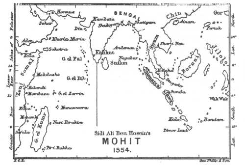
Sidi Ali Ben Hosein’s MOHIT 1554.
In order to enable the reader to judge of the extent to which the compilers of early Portuguese maps were indebted to native sailing directories and charts, and of the judgment exercised by them in their use, I insert here a reduction of Dr. Tomaschek’s elaborate reconstruction of a chart in accordance with the data contained in Admiral Sidi Ali ben Hosein’s “Mohit,” or “Encyclopædia of the Sea,” which, although only written in 1554, embodies the local knowledge gained in the course of centuries, and is not indebted to Portuguese charts for its superiority.468
The next chart to be considered is by Nicolas de Canerio, of Genoa. Its date is undoubtedly the same as that of the Cantino Map, that is, it was drawn before the results of João da Nova’s voyage had become available. This is proved by finding “y. tebas, iste insulle chamada secular” in the mid-Atlantic (9° S.), with a Portuguese flag, for these islands are borrowed from Juan de la Cosa, and have nothing to do with Conceiçao (Ascension) or St. Helena, discovered by João da Nova. It is almost wholly based upon the materials previously utilised by Cantino’s draughtsman, although more detailed in outline and with a more ample nomenclature in some places. The shape of Africa, however, is far more correctly given on Cantino’s chart than on Canerio’s,469 and the technical workmanship of the former is of a superior character. The legends on both maps have evidently been taken from the same source: those on Cantino’s map, as far as I have been able to examine it, appearing to be more numerous and in some cases fuller.
The MS. of this important chart is at present in the Hydrographic Office at Paris. Prof. L. Gallois, whose contributions to the history of geography are highly appreciated by all interested in the subject, has given an account of it in the Bulletin of the Geographical Society of Lyons.470 This account is accompanied by a reproduction of two sections of the map, viz., America and Africa. Prof. Gallois has had the extreme kindness to supply me with a tracing of the Asiatic portion of the map, and has thus enabled me to produce Map VII, illustrating this volume. My reproduction contains all the names of the original to the east of the Cape of Good Hope, whilst the legends for which there was no room upon the Reduction are given at the end of this Appendix.
On examining this chart it will at once be seen that the author—not the Italian copyist, whose name alone appears upon it—drew very largely upon native information. Still, he has not ventured to disassociate himself altogether from Ptolemy. He has, however, made some use of Marco Polo, though he puts the names taken from him—such as Murfulu, Var and Coilu—in the wrong places. The island in the middle of the Indian ocean—Y. rana—is not one of the Mascarenhas, as might be supposed, but the Illa Iaua of the Catalan map, that is, Java. The legend tells us that “In this island is much benjoim, and silk and porcelain.” Still further south there are three islands, representing the Mascarenhas, then known by Malabari names.
A few words remain to be said about the Portuguese maps published in the Strassburg edition of Ptolemy, in 1513. The originals upon which these maps are based were sent to Duke Renée II of Lorraine (died 1508), from Portugal. Uebelin and Essler, the editors of Ptolemy, state that they were drawn by an “admiral” of King Ferdinand. But Lelewel471 points out that the king meant must be D. Manuel of Portugal. They may have been forwarded together with the French translation of Vespucci’s Four Voyages, 1504, and Vespucci may even have had something to do with their compilation, even though not the actual compiler. But however this may be, and whatever the date of actual publication, there can be no doubt that they are identical in all essentials with Canerio’s chart, and must be referred to the same date, that is 1502.472
On placing side by side some of the above charts it almost looks as if they were not merely based upon the same original authorities, but had actually been slavishly copied one from the other, or from some common prototype. On a closer examination, however, this opinion is not sustainable, for the latitudes and longitudes assigned by the authors to the leading points will be found to differ very considerably. The following little table show this as regards the latitudes:—
—— True Lat. Cosa. Hamy. Cantino. Canerio. Strassburg Ptolemy.
Congo 6° 5´ S. 5° 30´ S. 7° 50´ S. 6° S. 10° S. 10° S.
Cape of Good Hope 34° 22´ S. 29° S. 30° 40´ S. 32° 45´ S. 34° S. 33° 40´ S.
Malindi 3° 20´ S. — 3° N. 3° 25´ S. 1° S. 1° N.
Calecut 11° 50´ N. 18° N. 13° N. 10° N. 13° 20´ N. 17° 30´ N.
Malacca 2° 13´ N. — 2° 30´ N. 14° S. 12° 30´ N. 8° S.
The latitudes from Dr. Hamy’s chart are referred to the Western Equator.
I now append the legends to be found in Canerio’s chart, together with a translation. The spelling is that of the original. A few legends from the Cantino chart, not to be found in Canerio’s, have been added. The bold Roman Capitals are references to Map vii. The printer is not responsible for the mistakes of the original copyist.
A. Aqui he amina douro emque dia multra abondancia de la mais que em outro.
(Here is the gold mine yielding greater abundance than any other.)
B. Aqui ha laquar et panos finos de toda sortes et figuos pasados et ubas et ensenso et almizquer et ambre et aljofar que tud bem de demtro pello a sertam da careto [cidade].
(Here are to be found lac, fine cloth of all kinds, corn, food-stuffs, grapes, incense, perfumes, ambergris and seed-pearls, all of which come to this city from the interior.)
C. Aqui he Caliqut he multo noble cidade descoberta pel el muy escarrado prip. Rey dom Manoel Rey de Portugall aqui ay molto menxas [benjoim] desua naturea [de fina natura] e pimenta et outras muitas mercedarias que vem de multas partes, & canella gengiber cravo emcenso sandalos et tode sortes de especiaria pedras de grande vallor et perlas de grande vallor et aliofar.
(This is Caliqut, the most noble city discovered by the most illustrious prince Dom Manuel, King of Portugal. There is here much fine benzoin, pepper, and many other kinds of merchandise coming from many parts, also cinnamon, ginger, cloves, incense, sandal-wood and all kinds of spices; stones and pearls of great value and seed-pearls.)
D. Aqui ha panos muitos finos de reda et dalgodom et aros e azucar et cera, e outras multas mercedarias.
(There are here very fine silk and cotton stuffs, and rice, sugar, wax, and many other kinds of merchandise.)
E. Aqui a sandalos e menxuim e ruibarbo e aiofa.
(Here are sandal-wood, benzoin, rhubarb and seed-pearls.)
F. Em esta cidade ha todas as mercadarias que bem a Caliqut, cravo e benjoym e lenhaloes e sandalos, estoraque, ruybarbo e marfim e pedras preciosas de muyto valor e perlas ed almizquer e porçelanas finas e outras muytas mercadarias. (From the Cantino Chart.)
(In this city are to be found all kinds of merchandise which go to Caliqut: cloves, benzoin, aloes, sandal-wood, storax, rhubarb, ivory, precious stones of much value, pearls, perfumes, fine porcelain and many other kinds of merchandise.)
G. Aqui ha chumbo almizquer e menzoy e sandalos.
(Here are lead [tin], perfumes, benzoin and sandal-wood.)
H. Aqui ha almizquer e sandalos e menioim e estoraque e linolos et chumbo.
(Here are perfumes, sandal-wood, benzoin, storax, aloes and lead [tin]).
I. Esta insulla chamada ataprobana he maior insulla que se en lo mondo et mais richa de todos os cousas s. auro e praia e predas preciosos et perlas et rubis muito grandes et finos et todas sortes de speciaria et sedas et borcados et a gente son idolatres et multo dispostas e tradam com os de fora et achan daqui multas mercedarias per a fora, e trasem outras que [nam] ay em esta insulla.
(This island, called Taprobana, is the largest island in the world, and is very rich in all things, such as gold, silver, pearls, precious stones and rubies of large size and fine quality; all kinds of spices, silks and brocades. The inhabitants are idolators and well disposed, and take much merchandise abroad, bringing back other kinds not to be found in their island.)
K. Aqui naca a canella e muitos sortes de espeçiaria, ed aqui pescam as perlas ed aljofar, sam as gentes de esta ylha idolatres e tratam muito cravo com Caliqut.
(Here grows cinnamon and many kinds of spices, and there they fish pearls and seed-pearls. The people of the island are idolators, and take many cloves to Caliqut.)
L. Em esta ylha ha gente do que comase huum as outras. (Cantino Chart.)
(In this island there are people who eat one another.)
M. Em estas tres ylhas nam ai nada sinam gente nuito pobre a nua (Cantino Chart.)
(In these three islands the people are very poor and naked.)
The following list of place-names includes all names found upon the maps referred to from the Cape of Good Hope to Malindi. Beyond that place the principal names only are given.
In addition to the names to be found on the maps, we have introduced those given in Duarte Pacheco Pereira’s Esmeraldo de Situ Orbis, written in 1505.
LIST OF PLACE-NAMES.
The authorities are referred to by Arabic numerals thus:—
1. Henricus Martellus Germanus. 2. Juan de la Cosa. 3. Dr. Hamy’s Chart. 4. Cantino Chart. 5. Canerio. 6. Strassburg Ptolemy. 7. Duarte Pacheco.
Place-names having an asterisk prefixed to them are mentioned in the Roteiro. The small letters in Italics refer to the Notes.
The Dates, in the first column, are those of the Saints after whom localities have been named.
In Portuguese. Names on the Maps. Modern Names.
*Cabo da boa Esperança 1, Cavo desperanza; 2, C. de boa esperança; 3, Cabo di bona speranza; 4, Cabo de boa esperança; 5 and 6, Cabo di bona speranza Cape of Good Hope
G. dentro das serras (gulf within the mountain ranges) 1, Golfo dnto delle serre; 3, Praia sabio (pablo?) a; 4, abaia False Bay
Ponta espinhosa b (thorny point) 2, Punta espinosa (chrinosa ?) Cape Hangklip
As serras 4, As seia (a serra ?)
Ponta de S. Brandãāo, May 16 2, Mastradios (nutrador ?); 4, S. biado; 7, Ponta de S. Brandam Quoin Point
Cabo das Agulhas Golfo das agulhas (Needle Cape or Bay) Serras seccas (dry ridges) 2, Punta de gra?; 7, Cabo dos agulhos 4. G. das Agullas 2, Sieras secos Cape Agulhas c Struys Bay Bare sandhills to E. of Struys Point
A bahia 2, Abaia dal es ... las Marcus Bay
A praia (shore) 4, Apraia
Cabo de Infante (Cape of João Infante) 3, C. de infante; 4, C. do infante; 5, Cabo donfante; 6, C. do infante; 7, Punta de infante Cape Infanta
—— 4, G. do Coberti St. Sebastian Bay.
Rio de Nazaret 2, R. de nazaren; 3, Croa de nazare; Breede River
Cabo do Salto 4, C. de resunancal ...; 5, Cabo do Ialta; 6, G. de Salco Cape Barracouta
—— 3, Rio de fo...oas Kaffirkuyl River
Rio dos vaqueiros (herdsman river) 1, Rio della vacche; 3, Rio vachoeros Gouritz River
Angra das vaccas 2, Angra das vaccas Flesh Bay
Cabo das Vaccas (Cow point) or C. delgado (slender or cattle cape) 2, C. delgado; 7, Cabo dos vaccas. Cape Vacca
Ponta da estrella (Star point) 2, Punta destrella Cape St. Blaise
Terra de S. João, June 24 and Dec. 27 5 and 6, Terra de S. Joham The country west of Mossel Bay
Golfo dos Vaqueiros (herdsmen bay) or Angra (aguada) de São Braz (bay or watering-place of St. Blasius) Feb. 3 2, G. de baguros; 3, Baia de anguada; 4, G. de Sanbras; 5, G. de Sanbras; 6, G. de Sanbras; 7, Angra or Anguada de S. Braz Mossel Bay d
—— 4, Rio de frung Harten bosch River
Serra de S. Lazaro, Dec. 17 3, Serra de S. Lazaro W. Outeniqua mountains (Brocks Bosch, 5,000 ft.)
Ponta da Pescaria (Fishery Point) 5 and 6, Ponta da pescaria Gerieke Point
Lago cerrado and Angra da lagôa 4, Alago carrado; 5, Lago cairado; 6, Lago cairado; 7, Angra de lagoa Zwarte Vlei
Serra da Estrella 3, M. dastrella; 4 Serra da estrella Outeniqua mountains
Cabo talhado (steep cape) 1, Cavo dalhado; 2, Punta de canar (astar? astros?); 3, C. ta... de 4, C. talhado; 5, Cabo talcado; 6, C. calcado Seal Cape
Bahia das alagoas (Bay of the Lagoons) 4, Abaia das alagoas; 5 and 6, Plaia das alagoas; 7, Angra dos alagoas Plettenburg Bay e
Terra das trovoadas (land of thunderstorms) 2, Montanas; 4, terra dos montes; 3, terra dos trovados Langekloof
Ponta de Ruy Pirez Costa da areia (sandy shore) 4, Punta de Ruyez ... 5 and 6, Costa darea Seal corner
Ponta (golfo) das queimadas f 3, Pta. da semados; 4, Pūta dasqūmadas; 5 and 6, G. dos quemadas Cape St. Francis and Krom Bay
Golfo dos vaqueiros (Herdsmen Bay) g 1, Golfo de pastori; 3, G, vacheoros; 5, Angra St. Francis Bay
Cabo do recife (reef cape) 5, P. do reciffe; 4, C. do arreciffe; 5 and 6, Cabo do recisi; 7, C. de recife Cape Recife
G. da Roca (rock bay) 3, G. do Roca; 4, Baia da Roca; 5, G. do raca; 6, G. daraca Algoa Bay h
Serra branca (white mountains) 3, Serra do blanco Zuurberg, or Addo Heights
Ilhéo da Cruz (Cross Island) 4, Ilheos da Cruz; 5, Ilheos da Cruz; 6, Insule de Cruz; 7, Penedo dos Fontes or I. da Cruz St. Croix Island
Ilhéos chãos (low islands) 4, Ilheoos chaos; 5, Ilheos chaaos; 6, Insule chaaos Bird Islands
Ponta do carrascal i (Green-oak Point) 4, Puta do carascal; 5, Porto de charseal; 6, Porto datharson Woody Cape
Padrão de S. Gregorio, March 12 1, Padrom de S. George; 3, P. de S. Gregorio; 4, Padro de S. Gregorio Cape Padrone
Rio da lagoa (Lagoon river) 3, Rio de lago; 4, Rio de lagoa Kasuga River
Praia das alagôas. 4, Praia das alagoas
Penedo das fontes j (Fountain Rock) 2, Penedos; 4, penedo da ... Ship Rock
Furna (cove) ... 4, Furna ... Port Arthur
Ilha de Infante 1, Ilha de Fonte; 2, Ys de ynfante Three Sisters off Riet Point?
*Rio de Infante 4, Rio do infante; 5 and 6, Rio de infante Great Fish river
—— 5, Cabo
Rio S. Thomé, Dec. 21 5, Rio san tome; 7, R. S. thome Umtata River
Ilha de S. Christovão, July 25 3, Ilha de San Xpistofa; 5, Ilheos San Cristofe; 6, Insule de S. Chrifero; 7, Ilheos de Sanxpono; Keiskamma Point k
Cabo primeiro (first cape) 3, Cabo primero; 4, Cabo primeiro Cape Morgan
Porto de Natal, Dec. 25 5, Gorffo de natal; 6, G. do natal Port Natal
Terra do Natal 3, Terra de Natall
Porto da pescaria 3, Pescarias; 5 and 6, Porto das pescarias Durnford Bay
Porto de S. Lucia, Dec. 13 3, Pr. de S. lucia; 5 and 6, Porto de Sta. lucia St. Lucia Bay
Terra das mesas (land of table-hills) 5, Tierram das mesas; 6, Tiram das mesas Flat hills S. of Cape Vidal
Rio dos medões de Ouro (river of the golden downs) 3, Modosdosoro; 4, Rio dos medos douro; 5 and 6, Rio do medos Kosi River
Serranias (mountain ridges) 5 and 6, Serramas Sandhills N. of Kosi River
Ponta dos medões (point of downs) 5, Ponta de medons Cape Colatto, 250 feet.
Terra dos Fumos n 3, Terra dos Fumos; 5, T. chrimias; 6, T. thrimias
Rio da lagoa o Rio do lagoa; 4, Rio da lagoa; 5 and 6, Rio de lago Umbelasi River, Delagoa Bay
Rio dos reis, Jan. 6 3, Ri do reis; 5, G. de lom raios De Barros confounds the Rio dos Reis and the Rio do Cobre Inkomati River
*Rio do Cobre p and *Terra da boa Gente 3, Agoa de bona passa; 5, Rio d’aguada; 6, Rio dagarda Zavora River
Barreiras 5 and 6, Bariras
Cabo das correntes (Cape of Currents) 3, C. das correntes; 4, Cabo das correntes; 5 and 6, C. das coreateso Cabo das Correntes
Cabo de S. Maria 3, C. de Sta Maria Ponta da Burra
Golfo das Manchas (g. of specks) 5 and 6, Gorffo (b.) das manchas Inyamban
G. de meros (g. of whitings) 5 and 6, Gorffo de meros Cove at Burra falsa
Cabo do Pichel (tankard cape) 3, Cabo de picell; 5 and 6, Cabo de pichel Shivala Cliff
Cabo de S. Sebastian, Jan. 20 4, Cabo de Sam Sebastiam Cape St. Sebastian
Ilha de S. Domingos, ? Aug. 4 3, Igoa decico texoda; 5, Ilha de Sam Domingo; 7, Insule S. Dominico Bazaruto Islands
Ilha de S. Sebastian, Jan. 20 3, Sanustiam; 5, Ilha de Sam Sebastiam; 6, Insule de S. Sebastiam Bazaruto Islands
Çofalla 3, Zafalla, Sofalla; 4, Cafalla; 5 Sofala and 6, flag shown, but name omitted Sofala
Rio de S. Vicente, Jan. 22 3, Rio de Sam Vincenso; 5, Rio de San Vicenso Pungwe River
*Rio dos bons q Signaes 3, Rio de bon signale; 4, Rio das bons sinaes; 5, Rio de bono futaes; 6, Rio de bonsuraes. Kilimani River
*Padrão de S. Raphael, Oct. 24 3, Padro de San Rafaell; 5, Porto de Sam Rafaell
Barreiras 5, Barreiras; 6, bareiras 3, “Questo avemo visto” (this we saw) r
*Ilhas primeiras s 3, Insulas primeras, 4, Ilhas primeras; 5 and 6, Insulla primeras Ilhas primeiras
Cabo das ilhas 5, Cabo dos ilhas; 6, C. insularum Makalanga Cape
Ilhas de S. Maricha 5, Ilhas de Sta maricha; 6, Insule de S. Maricha Angoshe Islands
Aguada do Lago 3, Agea do Lago 5, Ilhetos 5 and 6, Curaes t Angoshe River
*Moçambique 3, Mōsenbichi; 4, Moçambique; 5 and 6, Moncambiqui Mozambe
*Ilhéos de S. Jorge, April 23, p. 31 —— Ilhéo de S. Jorge
3, Monquique (duplication of Moçambique)
Rio de Fernão Veloso u 3, Rio de Fernanesso; 4, Rio de fernam veloso; 5 and 6, Rio do fernam Velloso Mazazima Bay
Furna (cove) 5 and 6, Furna
*Ilha do açoutado v 3, P. asoutado; 5, Ilha de acutado; 7, Insule de amrado Kiziwa Island
Ilha das palmas 5, Ilha das palmas; 6, Insule de palinis Ibo
Ilhas de S. Lazaro, Dec. 17 4, Ilhas de S. Lazaro Kerimba Islds.
Ilhas das cabaças (gourd islands) 3, Cabesa seca; 5, Ilhas das cabecas; 6, Insule das Cabeas Islands S. of Cabo Delgado
Cabo delgado 3, Cavo de Sco Cabo Delgado
Rio de S. Pantaleone July 28 5 and 6, Rio de Sam Pantaleone Lindi River
*Quiloa 3, Quilloa; 4, Quillua; 5, Quiola; 6, Quiloa Kilwa
Ilhas desertas 3, Ilha de sechas; 5, Ilhas desertas; 6, Insule desertas Islands thence to Mafia
—— 3, Ilha de baxo
—— 3, Baxo
Ponta redonda 3, Punta redonda Ras Kimbiji
*Zanzibar 4, Zamzibar
*Tamugata, pp. 33, 92 Mtamgata
*Baixos de S. Raphael w 3, Baxi dop lochio (i.e., farolhos, shoals); 4, 5, and 6, Baixos de Sam Rafaell Mtangata Reefs
*Serras de S. Raphael 3, T ... de Rafael; 5 and 6, Terra de baixos Usambara Mountains
*Mombaça x 3, Mombaça; 4, Mōbaça; 5, Monbacha; 6, Monbacha Mombasa
—— 5, Vutual; 6, butual
*Benapa, p. 40 —— Mtwapa
*Toça (Tocanugua) p. 40 —— Takaungu
*Nuguoquioniete (Quioniete), p. 40 —— Kioni
*Melinde 3, Melindi; 4, 5 and 6, Melinde Malindi
*Pate y 4, Pate; 5, Parte Pata
Bar (Land) Lamu 4, Berrama; 5, Berlama Lamu
*Magadoxo z 4, Mogodoxo; 5, Magadoxo; 6, Magadozo Mukhdisho
Obbia 5, Opim Obbia, 6° 40´ N
—— 5, Animalla, caralla, lacurcella, carapui, gargella (gargeia), cabo d’angra Along coast to Cape Guardafui
Socotora 5, Çacotoia Sokotra
Aden 5, Adam Aden
Mascate 5, Porto dama lemeniaco Maskat
Soar 5, Siffar Sohar
Ormuz 5, Collomoco; 6, Collomoro (Marco Polo’s Cormuso) Hormuz
—— 5, Betras; 6, Bertas Beyt Island, at entrance to Gulf of Cutch
—— 5, Dabo Diu
Cambaia *Cuambey; 4, Combaya; 5, Cambaia Cambay
Surat 5, Cuia; 6, Cura Surat
Baroche 5, paruça; 5, paruca; 6, Parnea Broach
Damão 5, Dema Daman
Canara 5, Canarea 5, Ginia; 6, Binia. The Ras boria of the “Mohit” 5, Meria. The Ras Meria of the “Mohit” Kanara
Ilhéos queimados (burnt islands) 5, Dobascha; 6, Dobastha. Dandabashi of the “Mohit” Vengorla Rocks
Goa 5, A flag, name omitted
Anjediva aa 5, Andegiba Anjediva
Ilhas dos pombos 5, Niture; 6, Nicare Netrani
*Ilhas de S. Maria —— St. Mary’s Islands bb
Onor —— Honowar
Mangalor 5, Māgalor Mangalore
Cananor cc 6, Cananor Cannanore
*Capua, Capocate dd *Capua (Capucate of Castanheda and Barros)
*Pandarani ee *5, Pandarani Pantharini Kollam
*Calecut 2, Calitcut; 3, Colochuti; 4, Caliqut; 5, and 6, Calliqut Calicut
Panane 5, Panade; 6, Panane Ponani
Cranganor 5, Cangalor. *Quorongoliz of the “Roteiro” Kranganur
Cochijn 5, Cochin; 6, Cothim Cochin
Coulãoo 5, Collium; 6, Collum. *Coleu of the “Roteiro” Quilon
Cabo Camorij 4, Comaria; 5, Cano de curiam Cape Comorin
Cael, *Cael 5, Cail. Qail of the “Mohit” Kayal, see p. 98
Mutapili 4, Mutapalay
Masulipatão 5, Tessulpata Masulipatam
Godavari 4, 5 and 7, Gudarim Godavari River
Satigam 4, 5 and 6, Çatiguam, the capital of Bangala. Shadigam of the “Mohit” Satgaon, on Hugli
Chatigam 4, Çatigam Chittagong
Arracam 4, Arecāni; 5, Arcagna Arakan
Pegú 4, Çatimpegno; 5, Carinpaguo Pegu, near the Satam or Sittang
Sadoe 4, Patoo; 5, Facto. Satowahi of the “Mohit” Sandoway
Martabão 4 and 5, Martabane Martaban
Tavai 4, Taoo; 5, Lioa; 6, Taoo Tavoy
Tenaçarij 4 and 5, Danasaguim. *Tenacar of the “Roteiro” Tenasserim
Cara 4, Carza; 5 Carta Kra
Tacoa 4, Tacoaa; 5, Tacoa Takuwa or Takoa
Modobar 4, 5 and 6, Modobar Meduar on Lingga River
Malaca 4, 5 and 6, Malaqua Malacca
Cingapura 4, Bar Singuapura; 5, Bar siniga- pura; 6, Barginigapor Singapore
Os baixos de Padua 4 and 5, Os baixos de Padua Munyal-par
Ilha malique 4, Malaqym; 5, Mallo. Molaki of the “Mohit” Minicoy
Ceylão 4, Cillam Ceylon
Triquinamala 4, Tragonamalay; 5, Traganollaneos; 6, Tragana Trincomali
Andemão 3, Bonae fortunae (Ptolemy); 4 and 5, Indana and Indrona Andaman Islands
Nicovade 4, Nagolarim; 5, Nagolainu Nicobar Islands
Çumatra 4, Ataporbana; 5, Ataprobana; 6, Taprobann Sumatra