CHAP IV.
Reading edition
Bights of Benin and Biafra — Rio de Formosa — Delta of Benin — Innumerable Rivers — Rio Forcados — Gatto Creek — Cape Formosa — Rivers East — New Calabar and Bonny River; their great magnitude — Old Calabar and Cross Rivers — Rio Elrei — Salt Ground — Great Trade in Salt — Face of the Country in the Delta — Trade to these Places — Inundation of the Rivers — Time of ditto — Shews they are different from either the Congo or the Egyptian Nile — Currents in the Sea near the Coast — Number and Magnitude of the Rivers in the Delta — Breadth — Depth — Trade — Natives into the Interior — a Race of People almost White — Leucæ Ethiopians of Ptolemy — General Observations on the N.E. and North parts of Central Africa — Accounts of Travellers — Kong — What it means — Great Magnitude of the Niger, and his Tributary Streams — Length of course — Compared to Magnitude of Bahr-el-Abiad at Shilluk — Cannot be the same Stream — No Connection with that River.
Let us now turn our attention to the rivers which enter the Ocean in the Bights of Benin and Biafra. Of the larger branches the Rio de Formosa, though not the largest, may be considered the parent stream from which all the others are deflections. At its mouth it is three and a half British miles broad, with two bars of mud, on which there is 13 feet water. Besides numerous creeks which issue from it, a very large, deep, and navigable branch flows into the lake Cradoo, which communicates with the Lagos river near its junction with the Sea. The space betwixt them, according to the French maps, drawn for the French Marine service, under the late Emperor, is filled with low islands; and several rivers from the northward fall into the lake, or sound mentioned, betwixt the Rio de Formosa, and the Rio Lagos. The account which Bosman gives of the Rio de Formosa, is the most particular and satisfactory which I have met with. “Upwards,” say she, “it is sometimes broader, and sometimes narrower. It sprouts into innumerable branches, some of which may very well deserve the name of rivers.” About five miles from its mouth, it throws off two branches within two miles of each other. Agatton, the chief place of trade, is situated sixty Dutch miles (220 British,) up the river, and on a Peninsula formed by it. “So far, and yet farther, ships may conveniently come, sailing by hundreds of branches of the river, besides creeks, some of which are very wide. Its branches extend into all the circumjacent countries. The country all about is divided into islands, by the multiplicity of its branches.” The Portuguese, who had settlements inland, and were well acquainted with those parts, affirm that “it was easy, with a canoe, to get from the Rio de Formosa into the circumjacent rivers, viz. the Rio Lagos, Rio Volta, Elrei, New Calabar, Bonny, and other rivers. The Rio de Formosa meanders through a fine fertile country, and brings down innumerable floating islands of considerable extent on its waves. On the north side, the river is joined by the Gatto creek, which may be the termination of a river descending from the north, perhaps the Kakoa heard of by Robertson. The Rio dos Forcados, apparently a mighty stream, no doubt branches off from the Rio de Formosa, after the streams running south-east have separated. South of the Rio dos Forcados, is a lake of considerable magnitude, which communicates with the sea, west of Cape Formosa, and also with the New Calabar river. The number of rivers which enter the sea from the Rio de Formosa to Cape Formosa, is six.
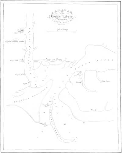
Passing Cape Formosa eastward, besides creeks, we have six rivers, which, at their mouth are all navigable. Beyond these, we come to the great estuary of New Calabar, and Bonny, or Bannee rivers. These streams form a junction near the sea, the one forming an island on the east side of the estuary, and the other an island on the west side thereof. The New Calabar river comes from the N.N.W. and the Bannee from the N.E. apparently at no great distance from each other; but still between them some streams from the north enter the sound formed by their junction. This grand estuary is eleven miles broad, very deep, and navigable for ships of heavy tonnage. On the west side is a bank of sand, thrown up by the action of the river and the sea. In some places it has thirty feet water on it. The New Calabar river, opposite to the town, and 40 miles from the sea, is six fathoms deep. In it, however, are many flats with only 16 feet water. The Bonny river is perhaps the most powerful branch: it divides, and forms an island about twenty five miles long, and twelve broad; the eastern branch, a very considerable stream, entering the sea under the name of Andonny, or St. Anthony’s river. The town of Bonny is situated on this island, which is almost level with the water, and a great part of it is flooded during the inundation. Inland, however, the inhabitants assert that the land becomes more dry, and the country free from those pestilential vapours which are generated amidst the swamps immediately adjoining the sea. The current out of the mouth of the united streams of the Bonny and New Calabar rivers is strong and rapid; and it is asserted that they discharge as much water as the great river Congo.
Thirty-two miles eastward from Andonny river, we come to the estuary of Cross river, and Old Calabar, or Bongo river. This estuary is twelve miles broad; but it may be considered as an arm of the sea rather than the mouth of a river, though the above rivers fall into it. This inlet penetrates into the country nearly 100 miles. At a considerable distance up this inlet, Old Calabar river is found to enter from the east. Its width and magnitude are considerable; but, tracing it eastward and upward on its course, it is, according to some authorities, found to pass over a large cataract which stops the navigation, and which indicates a course not of great length. Cross river is a branch of the Niger: our best charts represent it as coming from the N.E. This evidently is wrong, and should, I apprehend, be from the N.W. This Robertson asserts, and the name seems to bear him out; for it is by this stream that merchandize is transported from Old Calabar river to Bonny river, and the parent stream, the Niger, in order to be carried into the interior. Therefore, perhaps, it is named “Cross river.” In the French maps already mentioned, both these rivers are laid down as coming, the Old Calabar directly from the north, and the Cross river joining it from the N.W. In the latter, they are certainly correct. How far they are so regarding the former, future researches can only determine.
A small peninsula divides the mouth of the latter rivers from the outlet of the Rio Elrei. The estuary, or arm of the sea into which it falls, is ten miles broad. Both estuaries are very deep, and the navigation of either is safe. According to the accounts transmitted to the African Association by Nicholls, the traveller who fell a victim to the climate in endeavouring to explore this river, the Elrei comes from the eastward, and joins the sound, or arm of the sea, north of the high land of Rumby. Advancing up the river to the eastward, the land rises rapidly, and the Elrei becomes full of cataracts and rocks, obstructing the navigation. This shews that the sources both of it and the Bongo, or Old Calabar river, comes from the bosom of that mighty chain of hills which we shall presently see terminate on the coast a little to the southward. These rivers will thus be found to come from the south side of the mount Thala of Ptolemy. For the reasons mentioned, namely, cataracts and rapids, it is obvious that neither of these rivers can be branches of the Niger.
The country round the Rio de Formosa is uncommonly beautiful. Hence the name. It is also very populous; but, from being so low and swampy, it is very unhealthy for Europeans. The same may be said of the whole extent of coast intersected by the above mentioned rivers. The country to the northward, between the Rio de Formosa and Ardrah, is without hills, but, rising in a gentle swell, affords the finest prospect in the world. Inland, the country becomes more healthy, and the climate good. The land is extremely fertile. The trees are uncommonly large and beautiful. Cotton of the finest quality is amazingly plentiful; and indigo and other dye stuffs are to be had in abundance. The feathered tribes are innumerable. Horses, cows, and sheep are seen in great numbers. Weaving, and dressing of leather, are understood and practised. The Jaboos, an industrious people, carry on a great trade in grain, between Benin and Lagos. Benin is about ten miles from the river. Agatton is the port of the city. Benin is still a considerable place, though much decayed. The streets are long and broad; and it has regular markets every morning and evening. The houses, though built of clay, are handsome. Benin, when the Portuguese first discovered this part of Africa, was a powerful empire, extending westward to Elmina, and so far into the interior, as to be known to an empire distant twenty moons journey, in a N.E. direction, whose sovereign, being a Christian, it is supposed could only be Abyssinia. The extent of Benin is still considerable, their dominions extending twenty days’ journey from south to north. It claims sovereignty over New Calabar and Bonny.
The trade to these parts of the coast of Africa is very considerable, and annually increasing. The number of slaves annually exported from Bonny, and Old Calabar rivers, were formerly, and still continue to be, very great. They are chiefly brought from the interior by a water conveyance. The people are every where fond of trade, generally civil and obliging to Europeans who deal honestly; and they are anxious to cultivate commercial connections with them. All around the Delta, the population on the sea coast are busily employed in making salt for the interior market. In the kingdom of Qua, situated between the Andonny and Old Calabar river, this is particularly the case. The land on the coast is called the salt ground, and is, perhaps, the place where Ibn-al-Vardi mentions the numerous salt-pits on the shore of the sea. This salt is carried into the interior, along with other merchandize, in canoes or vessels, built around Bonny river, so large as to contain 200 people, and having a cannon placed on each end. They are covered with hides to keep them dry. (Robertson, p. 308.) Boussa, on the Niger, is a great emporium for this trade, and the place where the people from the sea-coast meet the caravans from Barbary, to exchange their merchandize. (Robertson, p. 301 and 209.) The natives on these coasts also talk familiarly of their trade, intercourse, and communication with Houssa and Timbuctoo. West of the New Calabar river also, is a country famous for the manufacture of salt, and called the brass-pan country, from the great demand for articles of this description from Europeans.
The rivers on the Bights of Benin and Biafra are in flood from May till December, but the height of the inundation is during the months of July and August. Then the Rio de Formosa covers all the land as far as Gatto, forty miles from its mouth, and fifteen from its bed. The inhabitants amongst the islands formed by its numerous branches, erect temporary villages, in which they live during the dry season, but which are all swept away during the rains. Such also is the situation of the country round the mouths of the New Calabar and Bonny Rivers, and, in fact, throughout all these coasts. Inland, the overflow of the river is very great; but we have no accurate account of the height. Shabeeny says, that it is so great that all the sheep, camels, goats, and horses, which feed on the banks of the river when low, are removed to the uplands during the flood. The land is constantly gaining on the sea, from the quantity of alluvial matter brought down by the different streams. Places near the mouth of Bonny River, which, within the recollection of traders of the present day, were stagnant pools, are now become dry and cultivated ground. In this manner, and during a succession of ages, has all the land in the Delta of Benin been formed. Every one of the natives on these coasts agree in stating, that, in the interior, near Benin, a great river from the northward throws off three branches, which pursue a southerly course to the sea, and one branch which runs westward to Lagos.
The time of the inundation of these rivers shew in the clearest manner that they can have no communication with the Congo. Their rise begins in May, and is at the height in July and August. The Congo does not begin to rise at the distance of 200 miles from its mouth, till the beginning of September. The distance from the Bight of Biafra, or the point eastward and inland, over which the Niger, if it flowed south to the Congo, would have to pass to the point where Tuckey first perceived the rise of the latter, is only about 560 miles. The current in flood from six to seven miles per hour, as Park found it in the Niger, (without reckoning any accelerated rapidity from rocks and cataracts) would reach the spot mentioned by Tuckey, in the Congo, in four days, and in six days, allowing one-third more for the turnings and windings of the river. For similar reasons, the Niger cannot be the Nile, because that river reaches its greatest height in Egypt, by the time the flood in the Niger is at its height about Yaoora, which is 4000 miles distant from Egypt, by the supposed course of the river, and one third more, making a moderate allowance for turnings and windings. The height of the flood also in the Bights of Benin and Biafra, being in August, is a most convincing proof that the waters which occasion it, come from places far to the northward and westward of nine or ten degrees of latitude, and in the same meridians, because the rains in the same parallels of latitude as the mouths of these rivers, are greatest in May and June. Their violence is past before August, whereas in the parallels between 10° and 20° north latitude, their violence is greatest in July and August. This being the case, shews that the height of the flood from those waters which pass Timbuctoo, and which come from Dar Saley, cannot be before August in the Bights of Benin and Biafra.
From the immense volumes of fresh water poured into the sea on these coasts, the currents are rendered exceedingly strong, and the swell and agitation of the waves very great and dangerous. The current in the sea sets to the northward, from the Congo along the coast of Africa, till it approaches the Bight of Biafra. Thence it is bent westward, through the Bight of Benin, and along the coast of Guinea. From the mouth of the Rio de Formosa it runs particularly strong to the westward. Bosman describes the excessive roll and turnings of the sea in this part in the strongest language: “The tide, from the eastward,” he says, “is so strong, that no shallop can stem it by rowing.” Having gained the shore through these terribly agitated waters, is, he says, to have “passed from hell to heaven.” Similar tides, swells, and currents, are invariably found off the mouths of large rivers, particularly all such as are flooded by the tropical rains. The mouths of the Maranon, the Orinoco, and the Ganges, have all similar phenomena near them.
CALABAR And Bonny Rivers. Surveyed by Captn. Newton W. H. Lizars Sculpt. Page 139.
When we reflect, for a moment, on the number and magnitude of the rivers which join the sea in the Delta of Benin, we are filled with wonder and amazement. From the Rio Lagos to the mouth of the Cross river inclusive, the number exceeds 20. The breadth of their surfaces connected together, would exhibit an expanse of fresh water perhaps 50 miles broad. Three of these only, viz. the Rio de Formosa, the chief outlet of the Bonny, and the estuary of the Old Calabar and Cross rivers, would make 27 miles. The depth of these rivers greatly exceeds that of other rivers of the first magnitude at their mouths. Thus, the Rio de Formosa has 13 feet water on the bars at its outlet, and deepens to several fathoms as it leaves the coast. The mouth of the New Calabar and Bonny has 7, 8, 10, 12, and, considerably upwards in the Bonny river, 18 fathoms; while the New Calabar, 40 miles from the sea, is six and seven fathoms deep. The chief mouth of the Orinoco has only 17 feet water on the bar, and the navigable part is no more than three miles broad. The Mississippi enters the sea by six channels, the two principal of which have only 12 feet water on the bar in each. Thus the outlets of the Niger greatly exceed either of these mighty rivers in the depth of their mouths. The distance from the source of the Missouri to the mouths of the Mississippi exceeds 4000 miles. The Delta formed by the Niger, exceeds in extent that formed by the Ganges, the Mississippi, the Orinoco, or the Wolga. In difference of longitude the Delta of Benin is nearly 260 miles. That of the Ganges, much larger than any of the others, is 200 miles. The navigation also of the outlets of every one of these mighty rivers is much more obstructed than the navigation in the mouths of the Niger. They have less water, and are more intricate and dangerous than either the Rio Lagos, the Rio de Formosa, the Bonny, and Old Calabar rivers. Of the depth of the Niger in the interior we are wholly ignorant; but, judging by the depth and magnitude of its branches at their mouths, we may form some idea of the depth of the united stream: It must be great. Inland, the Niger, before it is joined by any of the eastern rivers, is represented as two and three miles broad, and in its lower course five miles. (Bowditch, p. 201.) The united stream of the Orinoco at St. Thomas’ is four miles broad, and 65 fathoms deep, when the stream is lowest. The Ganges, inland, is three miles broad, and ten fathoms deep, when in flood. The united stream of the Mississippi, at New Orleans, is nearly one mile broad, and 20 fathoms deep. Higher up its breadth is rather more than a mile in some places, and from 200 feet to 35 feet deep. If we calculate from its breadth, the Niger will yield to none of these rivers in depth. The extent of country from whence it collects its waters, is, in breadth from east to west, greater than that part of South America which forms the immense Maranon; but, except in the meridian of Benin, little more than one-half the extent from north to south. The features, however, throughout the greater part, are of the same stupendous and magnificent description which are met with in those parts of South America. From the sources of the Misselad to the junction of the great eastern river with the Niger, the length of the Gir will, on general bearings, exceed 1600 miles. The Niger itself has a still longer course; and the stream that descends from Dar Kulla will have a course of 1000 miles to the place where it unites its waters with the former streams. Although the clearest information which we can obtain, leads us to fix the junction of these mighty rivers at the point mentioned, yet it is by no means improbable that this junction may take place lower down, or in the alluvial country nearer the sea.
It has been, and at various periods, stated, that vessels of considerable burden, navigated with sails and oars, and some of them manned by white people, came up the Niger from the eastward to Timbuctoo. Mandingo merchants informed de la Brue at Galam, that, some leagues from Timbuctoo, the Niger was navigated by “masted vessels.” Dr. Laidley, who resided long at Pisania, was informed, that vessels of 100 tons burden frequented Houssa, by which might be meant the country as well as the city of Houssa. A priest, who had visited Timbuctoo, informed Mr. Park, that “the canoes on the Niger were large and not made of a single tree, but of various planks united, and navigated by white people.” Major Houghton was informed by a Shereef whom he met with at Medina, and who had formerly known the Major when he was British Consul at Morocco, and who had been at Timbuctoo, that “they had decked vessels with masts, with which they carry on trade from Timbuctoo, eastward to the centre of Africa.” The crews of these vessels have been stated sometimes to exceed 150. These things were considered as fables. Late accounts, however, explain these relations in a satisfactory manner, and also confirm the accuracy of the earliest accounts which we have of Africa. Robertson has informed us of the great magnitude of the canoes or vessels built about Bonny river. We hear of no such vessels employed on either the Rio Grande, the Gambia, or the Senegal. With these vessels they trade up the river into the interior. He also states, that the natives from Tebo to the north of Benin “are whiter than Arabs, but are silky haired; and that the people on the coast give them the same appellation as white men, namely, Evoo.” These people are great traders, and go far into the interior; and there is no doubt but that it has been some of these people, with the large vessels mentioned, which have, at different times, made their appearance at Timbuctoo. It is far from being improbable also, but that they are “the particular kind of people” mentioned by Jackson, and the “white people” who dress in the style of Barbary Moors, and wear turbans, but do not speak Arabic, and who dwell on the borders of that lake into which the Niger discharges itself,” which Barnes heard of. It is very remarkable, that, in these parts of Africa, (for, if we examine his work accurately, we will find that it is hereabouts,) Ptolemy mentions and places a nation of white Ethiopeans, (Leucæ Ethiopeans.) The circumstances which we have mentioned prove the navigation of the Niger to be free and open; and Edrisi distinctly states that the Gir is so also, when he mentions that the vessels with salt from Ulil go up the Nile through the provinces of Ghana, Vancara, and Kaugha. All accounts concur in stating that the canoes which come down the rivers from the interior to the coast, are large and much finer vessels than those generally used on the south or the west coasts of Africa.
Some articles of European manufacture found in the interior also establish the fact of this channel of communication. Thus the schoolmaster at Tripoli informed Mr. Ritchie, that the uniforms of the King’s guards at Timbuctoo were red; and “that they were armed with musquets brought from the great Sea.” This must be the Bight of Benin, to which Europeans carry a great quantity of fire-arms. These articles do not come from the northward, for L’Hage Shabeeny expressly states that the traders from Morocco to Timbuctoo “carry neither swords, musquets, nor knives, except such as are wanted in the caravan.” (Jackson’s Shabeeny, p. 21.) The reason for this is obvious, for, if they carried these articles, they would arm and enable the Negroes to defend themselves, which is not the policy of either Moors or Arabs. Consequently, these articles must come through countries where neither of these nations possess any influence. All these things prove, in the clearest manner, the open, easy, and extensive communication by water, from the coast adjoining Benin, with the interior; a communication only found on this part of the coast.
In the northern, and north-eastern parts of central Africa, from Mourzook, to Darfur, and from the mountains of Eyrè to Timbuctoo, instead of burning deserts, and sterile wastes, and boundless swamps, we now, from good authority, find that there are numerous, powerful, fertile, cultivated, well wooded, watered, populous, and industrious states. Every where mighty rivers, from the east, from the north, and from the west, are found pursuing their course to the ocean, and verging to one grand point. Benin, Bornou, Asben, Bagherme, Dar Saley, Darfur, Kashna, Houssa, Timbuctoo, Sego, and Wassanah, and many others, are populous kingdoms, abounding in metals, minerals, fruits, grain, cattle, animals wild and tame. Kashna comprehends 1000 towns and villages. The population of Timbuctoo is estimated on the lowest scale at 50,000. Houssa is still larger. Wassanah nearly double, and Bornou still more extensive. The sovereign of Houssa, according to Shabeeny, can raise 70,000 horsemen, and 100,000 infantry. I am aware much must be allowed for Negro amplification, but still sufficient remains to shew us the importance of these places. Beyond Kashna, the camel, “that ship of the desert,” is no longer found; thus ceasing to be produced where his labours could no longer be generally useful or necessary, and in countries where he is not calculated to live. After passing Kashna to the southward and south-westward, the face of the country changes greatly. It becomes less open, and more intersected with great rivers, inundated roads, prodigious forests, and stupendous mountains, all the way to the gold coast. All these countries, all Central Africa, abounds with the elements of commerce; and her noble rivers afford the easiest, the safest, the cheapest, and most expeditious roads for the collecting and the conveyance of these. In all things, it is superior to what any portion of America, in the same parallels, or indeed in any parallel, afforded when Europeans first visited that quarter of the globe.
In the course of the Gir, or Nile of Sudan, as delineated on the map accompanying this work, it may be observed, that it is extremely probable the course of the stream in the middle part is still too much (perhaps a degree and a half) to the north. This would bring the lake Fittre into the latitude assigned by Ptolemy to the Nuba Palus. The bend, or angle formed by the river northward of Wara, is also, in all probability, much less acute than is represented on the map; and Wara is perhaps more to the west, and not so much to the north of Darfur. This would give the river, in appearance, a more natural course in those parts, and which the bearings given by the Arabian and native merchants would admit of without unnecessarily wresting their meaning. The rivers that descend from the north would thus have a greater space to traverse before these joined the Gir. On the other hand, the mountains which give these birth, may be more to the southward than I have placed them; and, in this particular, corresponding with the accounts given by Ptolemy more accurately than their position as supported by the testimony of Arab merchants. From 21° to 22° north latitude, there is reason to believe, is the true position of the highest chain of those natural barriers which divide the desert from the fruitful land. Northward, there is no doubt, lesser chains gradually decreasing in height, till these reach the desert. Northward of Ashantee, we have no difficulty in ascertaining the highest land. The magnitude of the rivers which flow S.E. point that out very distinctly. Thus we learn from Bowditch, (p. 171.) that at, and near Boopee, the Adirri and Addifoosoo, the two chief sources of the Rio Volta, are about 120 yards broad. Lower down, and in the route from Coomassie to Sallagha, the rivers Kirradee, and Oboosoom, running S.E. are each about 60 yards broad. These things are sure guides in determining the most elevated parts of the country. Independent of the positive testimony of Sidi Hamed, regarding the very high ridges of mountains in the central parts of Africa, with other concurrent circumstances, we have the positive testimony of various other intelligent Arabian travellers and merchants, that stupendous mountains cover these parts of Africa. Leo informs us that Guber is environed with mountains; and from Cashna, southward to Ashantee, all authorities agree in stating that prodigious high hills raise their lofty heads throughout all the space mentioned. The country northward from Ashantee to Sego and Jinnë is full of exceeding high mountains, which renders commercial communications almost impracticable. On the other hand, merchants and travellers who come from the country of Houssa, to the sea coast at Lagos and Bonny, make no mention of any particular chain of mountains, or inconvenience therefrom to travellers; but speak of heights, and complain chiefly of interruption and difficulties arising from large rivers, lakes, and morasses. This shews the parts of the country where the mountains become less elevated, and the land more open, thus affording an easy passage for the mighty rivers in their course to the ocean.
The word Kong is Mandingo, and signifies a mountainous country, and not one particular ridge. Did an impenetrable ridge, as is imagined, extend from Kong in 10° north latitude to Komri in 7° degrees north latitude, then the distance from its summit to Benin would not exceed 240 geographic miles. In such a distance, it is utterly impossible that so many, or indeed any one of the great rivers which enter the sea through the Delta of Benin, could be formed. From the westward none of them does or can come; and from the east it is equally obvious that they cannot flow. All this portion of Africa is mountainous; but it is evident these mountains admit a passage for the united waters of the Niger and the Gir from the northward, which, emerging from the mountainous districts, flow through a level country, and, in the lapse of ages, have formed the alluvial Delta of Benin.
In the Bights of Biafra and Benin, therefore, is the great outlet of the Niger, bearing along, in his majestic stream, all the waters of Central Africa, from 10° west longitude to 28° east longitude, and from the Tropic of Cancer to the shores of Benin. It is certain it is navigable from Balia, for Park informs us canoes can pass the rapids at Marraboo. This celebrated traveller descended the stream in safety to Boussa, where an accident terminated his life. The traders from the coast go up the river above this place. The course of the Niger will greatly resemble, on the map, that of the Orinoco of South America, and the length from the extreme sources (and those nearest its mouth) will be, on general bearings, 2250 geographic, or about 2600 British miles. The cannon, therefore, which thundered at Aboukir, and made the Nile tremble—those cannon which burst asunder, for ever, the chains of Christian slavery at Algiers, and which bore the fame of Britain[8] into the deepest recesses of Africa, may in safety awaken with their echoes, to obedience and respect, the uncivilized, or half civilized, nations of all Central Africa.
We have noticed, and from sure authority, the magnitude of the Niger at Bammakoo—in flood, one mile broad. At the ferry in the route to Houssa, it is described as two miles broad; at Yaoora, three miles. In other places it is stated by the Moors as five miles broad. We have noticed the magnitude of the Gir, the Shary, and the Tzad, in the early part of their courses—we have noticed the probable magnitude of the Bahr Kulla and the supposed Gulbe, all uniting in the Gir, which, where it passes through part of Kashna, with a rapid current, is twenty-three to twenty-four feet deep, and very wide; and having considered these things minutely, it is obvious that the united flood (making large allowances for African amplification,) must form a river equalled by few, very few, on this globe. The Maranon alone can exceed it. Neither sands can absorb, nor lakes contain, such streams. When Bowditch mentioned to the Arabs whom he met with at Ashantee, the European theory, that the Niger was lost in lakes or sands, they expressed the utmost astonishment. “God,” they said, “made all the great rivers to flow into the sea, and did Europeans think that he made the Quolla (Niger,) the greatest of them all, to be lost in the sands of the desert.”
It has been argued that the diminished size of the Bahr-el-Abiad at Shilluk, compared with that of the Niger at Bammakoo, and more eastward in its course, was easily accounted for by evaporation. This argument might have been allowed some weight, had it been shewn that the supposed course of the Niger from Timbuctoo to Shilluk lay through countries as dry and sandy as those countries are through which the Nile flows from Shilluk to the shores of Egypt. The reverse, however, is, from every information we can receive, the case. The country along the supposed course of the Niger, from Timbuctoo to Shilluk, is all remarkably hilly, woody, mountainous, in many places well cultivated, and abounding with large rivers, which must increase, not diminish, any great river which flowed through it. Again, it is argued that the Bahr-el-Abiad being full all the year, is a proof that it is the Niger. This account, however, proves the very reverse, because the Niger is not full, or in flood, (for so those who reason thus would take the expression used by Bruce,) all the year, but only during a part thereof. The expression, “full all the year,” however, does not mean that the Bahr-el-Abiad is in perpetual flood, but that it does not diminish in size during the dry season so much as the Bahr-el-Azreek, and other streams that flow from the south-eastward. That this is the true meaning of the expression is obvious, for Bruce also expressly states that “all the rivers in these parts fail when the sun goes South of the line.”
This continued fullness, or rather greater copiousness of the stream, during the dry season, in comparison with the eastern branches of the Nile, proves to a demonstration that the chief branches of the Bahr-el-Abiad either spring greatly to the southward, (some of them most probably do,) near the equator, or else considerably to the south-westward of Shilluk, amidst stupendous mountains covered with impenetrable forests, where the sun’s rays, during the dry season, have no influence in lessening the damps and moisture which give vigour to the springs, and where also the height of the mountains may be such, as melting snows may at all times add resources to the stream. From Donga, where the Bahr-el-Abiad is said to rise, to Shilluk, is above 300 miles. In an equal space, and through similar countries and Alpine scenery, the Niger becomes a much larger river than the Bahr-el-Abiad is represented to be at Shilluk. At its junction with the Bahr-el-Azreek it is said to be three times as large as that stream when it is low. At this junction, which is in 16° north latitude, the Bahr-el-Azreek can be crossed on foot, and is only mid-leg deep. The magnitude, therefore, of the Bahr-el-Abiad, calculated by the scale given, it is evident, cannot be very large. Besides, the Bahr-el-Adda intervenes between the Bahr-el-Abiad and the conjectured course of the Niger southward and eastward; and whichever of the former streams may be chosen as the continuation of the latter, still the theory in question exhibits the Niger in its lower course as running, not down from, but up against, the hills and high lands; for such are, and must be, situate about the sources of either the Bahr-el-Adda or the Bahr-el-Abiad. The latter also is represented, not as a still river, but of a current so rapid that a considerable distance is passed over before its waters are mixed with those of the Bahr-el-Azreek.
Considering all these things attentively, it is not possible that the Niger, and its collected waters, can flow to form the Bahr-el-Abiad, or the Nile of Egypt. They may have a communication. That is possible, but not probable. They are certainly distinct rivers. Can a river which is a British mile broad, as the Niger is at Bammakoo, in longitude 4° west, and latitude 13° north, flow through all Central Africa, passing in its progress east the parallel of 16° north latitude, and then returning south to 7° north latitude, through a country filled with stupendous mountains covered with snow, extensive forests, and drenched with tropical rains— Can such a river, receiving, as it does, and must do, mighty streams on either hand, flow again northward to north latitude 14°, and to the eastward as far as east longitude 33°; a distance, upon the general bearings of its course, equal to 2700 geographic (3127 British) miles; and then and there dwindle down to a stream such as the Bahr-el-Abiad is at Shilluk; the breadth of which, according to Browne, is only such that the human features could not be distinguished, but the human voice could be heard, by a person on the opposite bank? This breadth cannot exceed a quarter of a mile. The identity, therefore, of the Niger and the Bahr-el-Abiad, is, for this as well as for many other reasons too tedious to mention, altogether impossible. Swelled by the tropical rains, which make the dry-bedded torrents of the deserts of Africa become mighty streams, the Niger, with his accumulating, accumulated flood, would become a river of such force and magnitude, as would sweep all the cultivated land of Nubia bare as the rocks which there compose the bed of the Nile—bear Egypt and her cities headlong into the Mediterranean Sea, and cover perpetually, with its waters, all her land, fertile and sterile, from Rosetta “to the tower of Seyne.”