LECTURE III THE INDIAN OCEAN
Reading edition
LECTURE III THE INDIAN OCEAN
We leave Aden, with a mixed cargo of camels and Somalis, and steam southward for a hundred and fifty miles across the Gulf to visit the Horn of Africa, a region less known to Europeans, before the present century, than much of the distant interior of the vast Continent. We land 1 at Berbera on the flat coast: behind the little pier are the white houses of the European town, and in the background a long mountain range. Lying off shore at 2 anchor is a vessel which attracts our attention at once, as it reminds us of England; it is a sailing ship of the old type, far more graceful than our steamer, resembling the hulks which may be seen moored in some of our ports, with their sailing days long past. But here it is still in full use; it has lost its English name and become the Shah Jehan, and trades under the Persian flag, bringing dates once a year from Muscat on the Gulf of Oman. The seasonal visit of this ancient ship may serve to remind us that we are merely newcomers in this quarter of the world, and that it had its own busy life long before our arrival or the age of steamships.
In Berbera we find the Somali in his natural state. 3 The native town is a mere collection of primitive huts, made of mats, rags, mud and sticks; it looks like an encampment rather than a town; but we must not be too ready to judge the native by his house, as we shall see later that he has a good reason for not building a more permanent home.
Somaliland is rather larger than England and Wales together, yet a short excursion inland to the mountains will tell us nearly all that we want to know about the country and its inhabitants. Our way lies southward, across a desolate, stony plain, studded with dry thorn bushes; it does not seem an inviting country. The plain is narrow here, but further west towards Zeila it broadens out to over fifty miles. A few miles out, where we touch the foothills, we may be surprised to find springs of warm water, issuing from the limestone rock. On these Berbera depends for its existence, as there is no rainfall on the plain worth considering. Here we see one of these springs and here is the reservoir. Leaving 4,5 the plain we mount a steep slope and come out on a plateau; it is even more bare and stony than the plain 6 below. In front our track leads towards a long ridge, five thousand feet high, the Gorlis Mountains; on our left is the still higher range of Wagga. We cross the plateau and climb up the pass to Sheikh; here we see 7 our path by a rocky torrent bed. We must carry with us our own camp, as we shall find little shelter in this wild country and few inhabitants; though when we have pitched our tent for the night, we 8 have a visit from a native, armed with spear and shield, and curious to make the acquaintance of the white intruder. We notice that he seems very suspicious of the camera. At Sheikh we are in the heart of the mountains. 9 From the bungalow of the political officer we have a fine view down the long, steep pass, and can form some idea of the nature of the rugged country through which 10 we are travelling. Here is another view across the mountain ridges.
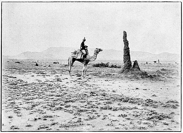
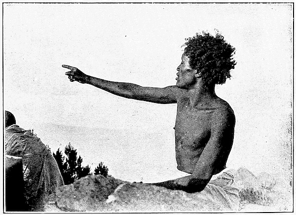
To reach the highest view-point we must ride eastward to Wagga, across another part of the plateau, dry and desolate as before. Dotted here and there are gigantic red pillars; these strange-looking shapes are not rocks 11 but ant hills; they are sometimes large enough to give us a little shade from the burning sun of the desert. We can judge the size of the hill before us by comparison with 12 our camel escort; and here is a closer view of another to help us. Far away in the background we can distinguish 13 the Wagga Mountains. The stony slopes of Wagga are less bare than the plateau, though the vegetation again is mostly thorns and aloes, with here and there a few cedars. After a long scramble we reach the summit, 14 up among the clouds, six thousand feet above the level of the sea. Here are two views from the summit, one 15 towards the east, the other towards the west; and here is our native guide, Giringh by name, pointing northwards 16 to where, over forty miles away, we can just catch a glimpse of the Gulf of Aden.
Let us try to realize where we are standing. If we 17 travel southward from Wagga or from Sheikh, we go downhill, but we find that the dried-up beds of the streams are sloping away from the sea. We have crossed the main water-parting of the country. The mountain ridges which we have scaled are merely the steep broken edges of a great highland block which falls gently southwards to a broad plateau, without hills or streams, a monotony of stones, red earth, dust and dense thorn scrub. In the dry season we may travel for a week or ten days together and find not a drop of water. On the caravan 18 routes are a few wells, such as we see here, but many of these dry up, and we have to dig for a few mouthfuls of warm, dirty water in the liquid mud at the bottom. This is the Haud; it belongs partly to Britain, partly to Italy and partly to Abyssinia, though in such a country boundaries have little or no meaning; they are merely imaginary lines drawn from a few known points through the unexplored area.
On the mountain slopes and on the plains at the foot are the courses of many rivers and streams. These are marked on the map, but few are permanent. In the rains they are rushing torrents, overflowing the channels which are too narrow to contain them and spreading out into wide unhealthy marshes; in the dry season they are mere channels or tugs, with a few stagnant pools in the deepest parts. The rains are of the tropical kind, beginning in April and going on, with one break, through the summer. The winter months are almost rainless, and the smallest annual fall is on the coast.
The peculiarities of the plateau and the seasonal rainfall have been largely responsible for the shaping of the Somali. He is essentially a nomad; all his property is moveable and consists of flocks and herds and camels. It is true that there are remains of stone buildings, and deep wells in the rock, especially further inland; but these are not the work of the present-day Somali; his house is as easily moved as his cattle. In the dry weather 19 we see the herds collected round the permanent wells and on the banks of the few streams where some water and pasture are still to be found. Notice the primitive 20 native method of getting at the water. A man is handing it up in a jar or skin, while another pours it into a trough for the cattle. The summer rains bring vegetation to the dry steppe, and forthwith the people with their animals migrate to the cooler air and fresh pasture of the plateau. Berbera and the coast towns empty themselves in this way in the hot weather, so that there is a great change in the size of the population at different seasons of the year. There is no real agriculture until we reach the borders of Abyssinia and the river valleys in the far south and west.
We can now appreciate the importance of the camel in the life of the Somali. Further inland, towards Harrar, where there is more pasture, the mule is to be found; but for the dry region of the Haud the camel is the only efficient beast of burden. Here we have him carrying 21 all the goods of his owner, fastened not to a saddle but to mats strapped round him. He appears to enjoy feeding on thorns and will travel for days together without water. He is also looked on as a great delicacy to be eaten by those who can afford it.
The natives of Somaliland are very different in race from the African people who live further south. Here 22 is a group of men, posed for the camera, with their little round shields and long, broad-bladed spears; 23 and here are some mounted warriors. The Somali is a born fighter, and his weapons are never very far away from him. The Somalis are an old Hamitic people, akin to the early inhabitants of Egypt and the races of the Mediterranean coasts of Africa. There is also a later admixture of Arab blood, due to the nearness of Arabia and the spread of Arab power in the Middle Ages all along the eastern coast of Africa. They themselves claim Arab descent and show much of the love of independence which is found among the Arabs. In religion, too, they are fanatical Mohammedans, and they have never really been conquered by an invader from without. For a few years the Government of Egypt occupied the coast towns and some posts in the interior in the neighbourhood of Harrar. When the Egyptians retired, in 1884, we at once occupied part of the coast as a dependency of Aden. About the same time the French took the corner opposite Perim, while a long strip of coast on either side fell to Italy. Behind all these is the independent native kingdom of Abyssinia. For a time British Somaliland was governed as a part of Aden; there was good reason for this since the country is of small value except in relation to the control of the Red Sea route, and is also entirely cut off on the land side from the rest of our African territory. It is now under the Colonial Office and is administered by a Commissioner, like so many of our smaller Crown Colonies and Protectorates.
To keep order in the coast towns there is a force of native Civil Police, under a European officer: here are 24 some of the havildars, and here the whole body in review order; but we see that, unlike our own police, they are 25 armed with rifles. Somaliland is not a peaceful country, and police alone are not enough; so a military force is necessary. This consisted formerly of a battalion of the King’s African Rifles, recruited partly from the natives and partly from India. Here are the drummers 26 and buglers, all natives, with a native officer; and here is a whole company of Rifles on parade. They are 27 mounted on mules, and the European officer alone is on horseback. This native force has been disbanded and replaced by a contingent of Indian troops. We have also, in the past, been compelled to employ British and Indian troops for expeditions up country, to deal with the followers of a Mohammedan Mullah who proclaimed a jihad, or holy war, a few years ago, and raided first the Christians of Abyssinia and then the natives in our own territory. The Mullah was only copying on a larger scale the usual methods of the tribes of the interior; since the chief amusement of the Somali consists in annexing the property of his neighbours, whenever and wherever he can find the opportunity. The geography of the country is all in favour of the native raider and against the civilized troops which attempt to catch him. In the dry season, when the Somali is for a time a fixture in the neighbourhood of the wells, it is almost impossible to move a considerable force up country, owing to the want of food and water for men and animals on the march. When the rains come, the whole country is open for the game of hide-and-seek, and in this the white man is no match for the quick-moving native, who is troubled by no problem of transport and is a nomad born and bred. The land itself fights for the Somali; so that effective European control is limited to the coast, except where the French have pushed inland with the railway from Jibouti to the neighbourhood of Harrar. None the less, the occupation of the coast towns, Berbera, Bulhar and Zeila, is not entirely useless, since these are the ends of the caravan routes from Abyssinia and the interior. Here the animals, skins, gums and other wild products of the country are exchanged for the rice of India, the dates of Arabia, and the cottons of Europe and America which form the sole dress of the native. For the rest, the Somali is likely to be left in the undisturbed enjoyment of his native customs; his chief visitor will be the sportsman and the naturalist, as the land abounds in wild game and is the home of many strange plants and animals which are not to be met with elsewhere in Africa.
We have made a brief survey of British Somaliland, and though much is not yet explored, yet it is not likely to differ greatly from the part which we have seen. There will be the same red dust and monotonous stony plain with its thorn bushes and dry stream-beds. In some parts, by way of variety, the thorn will grow so dense as to be impenetrable; in others it will disappear, and we shall find pure desert. Only a Somali or a camel could live and thrive in such a country. So we return to the coast and continue our voyage. Again we must 28 turn aside from the direct road across the ocean to India and follow for a time the long coast of Africa. We round Cape Guardafui, now the extreme tip of the Horn; but the sea here is shallow, and the islands which continue the line of the headland must at some remote time have been joined to the continent. Of these islands, Socotra, long and narrow, about a hundred miles from end to end, alone need be noticed. It is a British Protectorate, controlled from Aden, though nominally dependent on the little Arabian state of Kishin. It is without harbours or trade, and our only interest there is to prevent its occupation by any other Power which might dispute with us the control of the Red Sea entrance. Aden, Somaliland, Perim and Socotra have all the same place in our policy; they have no meaning except in relation to the control of the sea.
We steam onwards, and across the Equator, passing by the coastline of Italian Somaliland and British East Africa, to where, nearly two thousand miles from Aden, and close in to the mainland, are two other islands coloured red on the map, Pemba and Zanzibar. We are a long way off our course to India, yet Zanzibar and the narrow strip of coast behind it belong by history and development to India and Arabia rather than to the neighbouring continent.
The Portuguese, on the way to India, creeping along the coast in their old-fashioned vessels, found here Arab traders and Arab cities with an active intercourse across the Indian Ocean. The periodic Monsoon winds brought the fleets of dhows, with the produce of India and the Persian Gulf, and carried them back with their cargoes of ivory and slaves. The Portuguese occupied the African coast region as part of their Indian Empire; the English and Dutch, at a later time, made straight across the ocean from the Cape or Mauritius and left the Portuguese undisturbed. So, when the rule of Portugal collapsed through its own weakness, the old conditions were restored.
For a long time Zanzibar and the neighbouring coasts were ruled by local chiefs, nominally dependent on the Iman of Muscat in southeastern Arabia; until, early in the nineteenth century, Seyyid Said transferred his court from Muscat to Zanzibar and extended his power over all the neighbouring coast. On his death, in the middle of the century, Zanzibar, largely through the influence of the Viceroy of India, was separated politically from Muscat. It remains to-day in name an independent kingdom, though stripped of its dominions on the mainland and under the Protection of Britain. We became concerned with this region, in the nineteenth century, mainly owing to our efforts to suppress the slave trade of which it was the chief centre. We found it impossible to carry out our policy without some effective control over the native states, and our paramount interests in Zanzibar and the mainland to the north have been recognized in our agreements with France and 29 Germany. To-day the palace of the Sultan still remains, but on the site of the old slave-market stands the Cathedral 30 as a sign of the success of our efforts.
The island of Zanzibar is long and narrow; it measures about fifty miles from north to south, and only twenty-five at its widest in the middle. It is nearly three times the size of the Isle of Man. A long ridge of hills divides it into two distinct parts. The east is largely made up of old coral rock, with a very thin layer of soil; it is not very fertile and is, moreover, exposed to the full force of the Trade winds. Most of the population is on the more sheltered western side, and here are the town and harbour of Zanzibar. The ruling class and original landowners are Arabs; but the mass of the people are Swahili, of mixed African and Asiatic descent, and freed 31 slaves, largely natives of Africa. Here is a typical group of natives. The chief wealth of the island lies in the cultivation of cloves, as a large portion of the world’s crop is grown here; but there are also the coconut palm, the rubber vine and many other tropical plants. A great and interesting change is taking place in the ownership of the plantations: the natives of India, shopkeepers, traders and moneylenders, are steadily ousting the Arabs. The Arab has lost much of his wealth, through the emancipation of his slaves, and is slow to adapt himself to the new conditions; so that the thrifty Indian bids fair to annex the whole island in the near future, and Zanzibar will renew its connexion with the mainland on the other side of the Indian Ocean.
Apart from its agriculture, the chief value of the island is in the sheltered roadstead of the capital, as good harbours 32 are rare in this part of the world. Here we see it from the sea, and here is one of the main streets of the town. In 33 Zanzibar we find all the races of the Indian Ocean represented, and here are collected all the products of the islands and of the coast of Africa, which is only twenty-five miles away. The trade with India still remains, while the steamship has brought also direct intercourse with Europe. In the early days of trade, the security of a position on an island was an important factor in the growth of a seaport; now that Europe is policing both the sea and the mainland, the advantage of the island is less, and Zanzibar has a growing rival a hundred and fifty miles away on the coast of Africa. Mombasa 34 is on a small island, connected with the mainland by a causeway. On the north side is Mombasa harbour, 35 rather shallow and not very convenient for shipping; on the south is the deep Kilindini channel, running for a long distance inland and providing one of the finest harbours on the east coast of Africa. Mombasa is the terminus of the railway which crosses the low coast strip and surmounts the plateau of East Africa. The trade of the port is very old; but only slaves and ivory could be carried in former times over the long and difficult caravan route which ended here. Now, the railway can bring down to the sea all the products of a vast 36 area inland. Here we have a scene on the old road, and here by way of contrast the modern railway. 37 Mombasa, like Port Sudan, will create a new traffic in the future, to join the great stream which moves through the Indian Ocean and the Suez Canal; but the subject of British East Africa and its resources must be left for future treatment; here we are concerned only with its relation to our sea route.
Copyright.]
[See page 40.
Ant Hills, on the road to Wagga.
Copyright.]
[See page 41.
A Somali Guide.
Copyright.]
[See page 56.
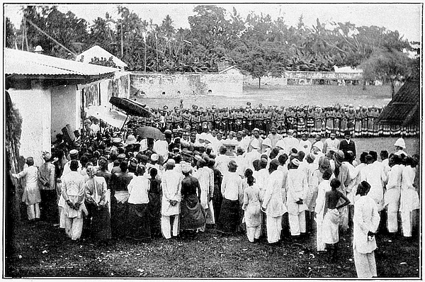
Reception by the Sultan of the Maldives.
Before we turn towards India we have yet another island to visit, an island connected not with the new, but with the old route to the East. This is Mauritius, lying east of Madagascar and well out in the Indian Ocean, about two thousand four hundred miles from Aden and rather less from Ceylon. We shall find it very different from Zanzibar. A French patois is the language commonly spoken; most of the names on the map are French, and the statue of a great Frenchman 38 is one of the first things which we notice on landing at Port Louis. Mauritius was in effect a purely French colony, when it became ours by conquest just a century ago; but the immigration from India is now modifying rapidly the French character of the island.
Before the French were the Dutch: they settled first in the southeast corner, as Grand Port was the last convenient point of call on the way from the Cape to Ceylon, before the long voyage across the open ocean. After a century of partial occupation, the Dutch retired in 1712, leaving behind them the name Mauritius, taken from that of Count Maurice of Nassau, the Stadtholder of Holland. The French, who were already in Madagascar and the neighbouring island of Bourbon, promptly occupied Mauritius, re-naming it Île de France. It was controlled by the French East-India Company and became in a few years very prosperous under the administration of Mahé de Labourdonnais. His name still survives in Mahébourg, and we have already seen his statue in Port Louis. During our war with France at the end of the century, Mauritius, owing to its position on the only route to India, was used as a base for attacking our commerce by the French privateers who swarmed in these seas; so that its capture became necessary for the security of our Indian possessions. Both Bourbon and Mauritius were taken, but the former was restored to France by the peace of 1814.
The island as we found it was a true French plantation-colony. The ruling classes were the Creole landowners, French by descent; while the actual work of the plantations was carried on by slaves imported from Africa. It is still thoroughly French, and the plantation system survives in a modified form as the sole support of the people; but the former importance of the island as a commercial and strategic centre has greatly declined with the opening of the Suez Canal. Mauritius is no longer on a great trade route, but it is well worth a visit in itself and is still closely connected with our final destination, India.
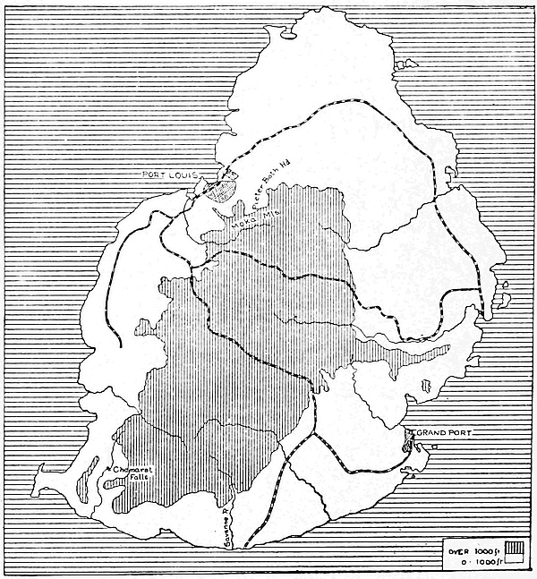
Mauritius.
We must first make a brief survey with the map. The 39 island is in the form of a rough oval, a little over thirty miles long, less than half the size of the county of Kent. Its coasts are fringed with coral reefs, broken here and there by gaps, especially where the streams of fresh water enter the sea. Behind these gaps are the seaports, of which only two are of any size, Grand Port or Mahébourg at the southeast corner, and Port Louis, the capital, in the northwest. Grand Port was occupied first, but 40 it is open to the Southeast Trades; so that Port Louis, like Zanzibar, on the sheltered side, and with a good harbour, has become the chief port for the whole island. In the north and part of the east and the southeast corner the land lies fairly low; here we find the chief towns, the plantations and most of the population. A great deal of the centre and south is filled up with hills and plateaux; some of the peaks rising to over two 41 thousand feet. Here are the Moka Mountains, behind Port Louis, steep and rugged, crowned by a strange peak, Pieterboth Head, which is a useful landmark for 42 sailors. Notice the Dutch name. In the southwest the hills are very near to the sea; the coast plain is narrow, the slopes are steep and the rivers come down in rapids and falls amidst wild and beautiful scenery. 43 Here is the Chamarel fall and here again are the falls on the Savanne River. The railways are a fair guide to 44 the structure of the country, as they keep for the most part to the lowland or the river valleys, except where the main line from Port Louis to Mahébourg is forced to surmount the middle of the plateau; while the Moka branch crosses a steep ridge on its way to the lower country to the east. Here we see one of the curious 45 trains crossing one of the mountain streams at the foot of the bare hill slopes; the picture gives a good idea of the scenery on the railway.
The rainfall in Mauritius is heavy in the summer months, December to March, especially on the east side of the hills, where the wind comes straight in from the warm ocean; and the temperature is high, at sea level, as Mauritius lies on the edge of the Tropics. Heat and rain, together with a rich volcanic soil, have made Mauritius what it is to-day. Agriculture is the only occupation of the people, and the only important crop is the sugar-cane. This was first introduced from the East India Islands by the Dutch, though little progress was made with its cultivation until the time of the French settlement. The forest which then covered the island was cleared away, and the cultivation of the cane, by means of slave labour on large plantations, became the staple industry of the new colonists. Large fortunes were made in the early part of the nineteenth century, but Mauritius, like the West Indies, has suffered greatly from the competition of beet-sugar, and its trade has declined greatly, though it has still a good market in India. Too much dependence on a single product has brought ruin on many of the planters. Here is a picture 46 of one of these large sugar estates. In front of us we see the cane growing and the planter looking over his crops; the ugly building, with the chimney, which spoils the middle of the picture, is the mill where the cane is crushed to extract the juice.
The cultivation of sugar in Mauritius, like that of tea in Ceylon, has produced remarkable changes in the character of the people. When slavery was abolished, in 1835, new sources of labour for the plantations had to be found, and Indian coolies were imported on a large scale. These usually remained when the term of their contract was over; with the result that at the present time about three-quarters of the total population of the island is of Indian descent, the majority having been born in the island. We find them everywhere in 47 the island, living contentedly in primitive huts and cultivating their small patches of land. They are steadily acquiring the land in small plots and manage to exist comfortably even under present conditions. In short, Mauritius is becoming more and more an offshoot of India, since not only the labour but much of the food supply must come from the rice fields of India, so long as nearly all the land under cultivation is given up to a single crop like sugar. The climate, too, is more suitable to the brown than to the white people; malarial fever is always present, and the general conditions have not been improved by the cutting down of the greater part of the forest. Sometimes the weather brings disaster in a swift and sudden form, as Mauritius lies in the track of the cyclones which whirl in from the northeast, especially in March and April, and travel southwards towards Madagascar. In a few hours one of these terrible storms can destroy houses and plantations and undo the work of years. One of the worst of these, in recent years, struck the island in 1892; and here we see some of the 48 damage done at Port Louis. The planter in this beautiful island has truly many difficulties to contend with. It is possible that the growth of trade in Madagascar and on the neighbouring coasts of Africa may bring back a little of its past prosperity to Port Louis; but Mauritius can never regain the position which it enjoyed before the piercing of the Suez Canal.
If we look at the map showing the depths of the Indian (28) Ocean, we notice that Mauritius, with the sister French island of Réunion, rests on a relatively shallow bank, raised above the ocean floor. Following this bank northwards for nearly a thousand miles, we come to a whole group of little islands which are connected by a similar bank with Madagascar. The most northerly of this group are the Seychelles. Another great bank runs southward from India with scores of islets on it. In the north are the Laccadives, close to the coast of India; in the middle are the Maldives; and in the far south, beyond the Equator, right out in the ocean, is the little Chagos Archipelago, including the coral island of Diego Garcia, where at one time there was a small coaling station used by vessels bound to Australia. All these islands are but the fragments of a sunken land-mass which at a very early period of the worlds history joined South Africa to India. They are widely separated if we look only at the surface of the sea, but really joined together if we look below.
Mahé, the largest of the Seychelles, has an area of rather over fifty square miles, a little more than that of the island of Jersey; we could walk from end to end of it in a few hours. A map, showing Zanzibar, Pemba, 49 Mauritius and the Seychelles on the same scale, may perhaps help us to realize their relative size and shape. There is one good harbour in Mahé, on which stands Victoria, the capital, where steamers sometimes call on the voyage from Aden to Mauritius or from India to 50 Mombasa. Here is a general view of the harbour and here is a street in the little town. The whole group was 51 dependent on Mauritius and was given up to us at the same time as that island. The language of the people is still modified French. The Seychelles are fertile and beautiful and not unhealthy, in spite of their nearness to the Equator. They naturally abound in tropical plants, among which the coconut palm is the most valuable to the natives. Here are some of 52 these palms with the mill where the oil is extracted from the nut. Here also we see a species of fan palm, 53 which has a strange history. Centuries ago, the Portuguese found washed up in the Maldives and on the southwest coasts of India a curious double nut, the coco-de-mer. 54 The tree which produced the nut was unknown and could not be discovered in the neighbouring islands, so the fable was invented that it grew in the depths of the sea. The nut was much valued in India as a medicine, but in spite of careful search not until the end of the eighteenth century was the parent tree found in the Seychelles, where alone it grows. The Southwest Monsoon, blowing for months at a time, carried the nut all the way to India, just as it brought the fleets of Arab dhows from the coast of Africa. So we have in this tale of the nut a useful reminder of the climate of the Indian Ocean. We will now leave the Seychelles after a glance at another strange product of a neighbouring 55 island, Aldabra. This is the giant tortoise. It was at one time very common in this part of the Indian Ocean, as we learn from the accounts of early voyagers, but it is now rare.
Mauritius and the Seychelles, with many of the smaller groups and islands in the Indian Ocean, came into our hands in connexion with the development of the old route to India by way of the Cape. There is one group, among the nearest to India, which through all the changes of Portuguese, Dutch and British occupation has succeeded in maintaining a partial independence. The northernmost of the Maldive islands are only about four hundred miles from the coast of Ceylon, within easy reach not only of the road from Africa and the Seychelles to India, but also of the more important road from Arabia, the Red Sea and the Persian Gulf to the Malay Archipelago and the Far East. The language of the people, as we might expect from the near neighbourhood of Ceylon, is closely akin to old-fashioned Sinhalese. We may perhaps regard the people as colonists from Ceylon, with a large mixed element due to the Arab traders who must have visited the islands often in their voyages. The Maldives have always followed the fortunes of Ceylon; they have recognized in turn Portuguese, Dutch and British authority, but have succeeded in avoiding complete annexation. This may be due partly to the fact that there is little in them to attract invaders. The islands which make up the group are mere coral atolls, with no good harbours, a very small supply of good water, and few products for trade. The 56 Maldive trading fleet, which we see here, does not suggest a very heavy traffic. What there is, mostly dried fish, finds its only market in Ceylon, which sends, among 57 other things, fresh drinking water in return. The Sultan is on good terms with our officials: here we see him, 58 with his suite, visiting a British warship, and here he is receiving the return call of the representative of the Governor of Ceylon. The connexion with Ceylon is formally recognized once a year, when a solemn embassy comes from Malé, the chief island of the group, to Colombo, to greet the representative of the Suzerain 59 Power. So we conclude with this embassy, which has finally landed us in Ceylon.
In our voyage from the Gulf of Aden to Colombo we have made a great circuit of the Indian Ocean, yet from beginning to end we have never lost touch with Indian trade and Indian people. The islands and ports which we have visited are only to be understood as parts of a larger whole, united not divided by the sea. We speak rightly of the Indian Ocean, since India is and always has been the central fact in the life of this region, both politically and economically. This was as true in the earliest days of the Arab traders as it is to-day. We have replaced sails by steam, cut the Suez Canal, and changed the direction of the main ocean route; but as soon as we pass the Strait of Bab-el-Mandeb, we find that our route is only one of many. We are in a network of traffic and intercourse which was in existence centuries ago, long before the first European keel broke into the eastern seas.