LECTURE II MALTA TO ADEN
Reading edition
LECTURE II MALTA TO ADEN
On our voyage from the English Channel to Malta we are never out of touch with the countries of Western Europe. Even on the African coast European influence or control is becoming stronger every year. We have seen how our occupation of Gibraltar was incidental to our quarrels with France and Spain, and these same quarrels, in the end, brought Malta into our possession. But Malta is on the edge of the Near East, and in looking at its history in mediæval times we were always concerned with the rivalry of the West with the East, Europe with Asia. So even to-day, though Europe has proved itself the stronger, we shall find that beyond Malta we enter a new world where the relations of West and East are not yet finally settled. This uncertainty is shown alike in our own position and in that of the other great Powers of Europe. The problem of the Near East is still one of the chief worries of diplomats and governments.
From Malta to Aden is perhaps the most important section of the great trade route which we are following; yet right through, from the entrance of the Eastern Mediterranean to the outlet of the Red Sea, in spite of our great commercial and political interests, we shall not find a single acre of British freehold territory. Even as far as Malta we can only claim that part of the road is British, since, in time of peace, the important mail 1 traffic goes through France and Italy, from Calais to Brindisi. In fact, for our complete traffic, in passengers, mails, goods and ships, we might regard Aden as the first British station on the road to India.
So, at the European end of the journey, owing to the modern development of rapid transit, we are more and more dependent on the kindly offices of foreign nations. Beyond Malta conditions are different. Though we have no freehold possessions, the waterway is free to all, and we have agreements and rights of various kinds affecting its use and control. We must learn something of these rights, since Malta and Aden lose half their meaning for us unless we understand the nature of our interests in the intervening links in the long chain of communication.
As we steam eastward from Malta, on our way to Port 2 Said, we may pass within sight of the island of Crete. Here we are entering on the new region, as Crete has relations both with Europe and with Asia, and the ultimate form of these relations is still in doubt. Crete is a debatable ground between Turkey and Greece, and Britain is concerned with three other European Powers in determining its destiny. Further east, in the same latitude as Crete, lies Cyprus, which we must now notice, since its administration is in our hands, although it seems a long way out of our direct course to the East.
The island lies far away from the Greek Archipelago, in the angle formed by the coasts of Syria and Asia Minor, where the Gulf of Antioch runs in between the Taurus mountains of Cilicia and the northern continuation of the coast range of Lebanon. It is a region rich in history. On either side of the Gulf are the ancient sites of Tarsus and Antioch; inland is the commercial city of Aleppo, and beyond it the headwaters of the great river Euphrates. This small corner of the Mediterranean, now comparatively neglected, was of great importance in the ancient world; and some knowledge of its past may help us to appreciate its position at the present day.
The origin of the first inhabitants of Cyprus is doubtful, but we know that in historical times Phœnicians and Greeks were settled here in large numbers. Kitium, near the modern Larnaca, was Phœnician, while Salamis, near Famagusta, was one of the chief centres of Greek influence. These and many other cities, little kingdoms in themselves, were well known to ancient historians; though the whole island is only about twice the size of Lancashire. Cyprus in early times became famous for the worship of the Phœnician goddess Astarte, the Aphrodite 3 of the ancient Greeks. Here we can still see the Phœnician rock tombs, and here are fragments of the 4 marble columns which once supported a great temple of Zeus. Perhaps, too, these vast heaps of slag, relics 5 of the old workings for copper, which took its name from the island, may be due in part to the people who are thought to have reached even our own islands in their search for tin. But for the most part, bombardments, earthquakes, destructive natives and foreign searchers after antiquities have left few remnants of the ancient civilization except such as are buried beneath the earth. The real interest of Cyprus for us lies rather in its political history in mediæval and modern times.
In the ancient world it came under control of one after another of the great Powers ruling the mainland: Egypt, Phœnicia, Assyria, Media; though the control was often nominal, being limited to the levying of tribute, and the little native kingdoms maintained a partial independence. Our own history has shown us the value of a few miles of water as a protection from the great military Powers of the neighbouring continent. As a trading centre and naval base, on a coast where good ports were few, Cyprus was of great value, and we are not surprised to find that sea fights are frequent in its history. The Romans annexed it from Egypt; at the division of the Empire it was attached to Byzantium, and though it was twice conquered by the Arabs it was twice recovered. Here we see it already a bone of contention between East and West. For a few months in the year 1191 Cyprus was even English territory. It was seized by Richard I. on his way to the third Crusade, and in 6 the little town of Limassol which we see here, he was married to Berengaria of Navarre by no less a personage than the Archbishop of York. So we may claim that our connexion with Cyprus is at least seven centuries old. Richard sold his new possession to Guy de Lusignan, a French Crusader, and thus Cyprus like Malta came under the influence of Feudalism and the Latin Church. Its external history, also, like that of Malta, is made up for three centuries of fights and raids of Christian against Mohammedan. Unlike Malta, it was fated in the end to become part and parcel of the East. Towards the end of the fourteenth century the Genoese seized Famagusta, which they retained for many years; and a century later the abdication of its last ruler, a Venetian by birth, gave the whole island to the Republic of Venice. Venice and Genoa were both naval and trading Powers; the island was a good base both for trade in the eastern Mediterranean and for warlike operations against the Turk.
We can still see the lion of Venice and the old inscription 7 on the fortifications of the citadel of Famagusta, and here too is a fragment of the ancient palace of the Lusignan 8 dynasty, which has escaped destruction by the Turk only to be converted into a prosaic police station. Unlike the knights of Malta, the Lusignans made little impression on the natives of the island. They attempted to replace the national Greek Church by the Latin; yet the old Latin cathedral of St. Sophia is now used as a mosque, while, in spite of occasional persecution, the Greek Church still survives as the Church of the majority 9 of the people. Here is the outside of St. Sophia: it is partly ruined, but we can see that it was once a fine building. 10 Inside, it still looks like a church, except for the presence of Mohammedans wearing turbans. Out in the country, near Nicosia, we come on a fine old monastery, 11 still in the possession of the Greek Church. Notice the monks in their curious dress. Not far away is a once-famous 12 abbey, now somewhat decayed, as we may judge from a near view of the cloisters; here again is an ugly 13 modern village church, and here by way of contrast a famous tekkye, or Mohammedan shrine. Everywhere 14 Turk and Cypriote, Mohammedan and Christian, are side by side; and behind all is British power enforcing 15 law and order and compelling the different parties to live at peace with one another.
Cyprus of to-day is what the Turks have made it, since they conquered it from Venice in 1570; we have succeeded to a heritage of mis-government, and the conditions of our tenure hamper us greatly in the task of bringing back prosperity to the people. In 1878, after the treaty of San Stefano had been forced on Turkey by Russia, we agreed to defend the Asiatic dominions of the Sultan against further aggression, on condition first that reforms were introduced for the protection of his Christian subjects, and secondly that Cyprus should be occupied and administered by Great Britain. We added to the agreement an undertaking to pay annually to the Porte the surplus revenue of the Island at the time of the occupation, and to evacuate Cyprus if ever Russia should restore Kars and her other Asiatic conquests to Turkey. This undertaking has retarded the progress of the island under our rule in the past, since this tribute, which now goes to pay the interest on a Turkish loan, represents a steady drain on the revenue, so that it has been found necessary to make an annual grant-in-aid from the British Treasury.
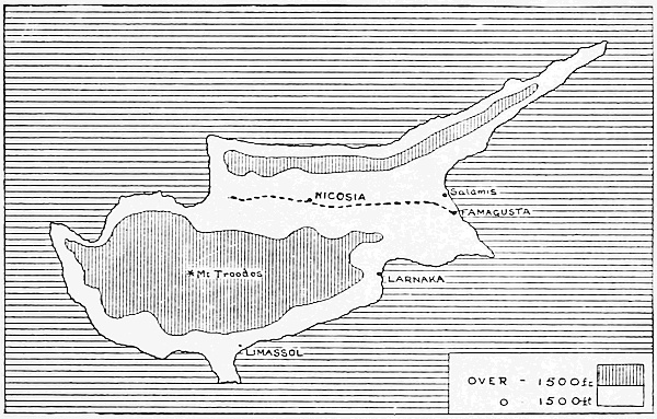
Cyprus.
Yet Cyprus is capable of great improvement. It was famous in the ancient world for its beauty and fertility, and at one time supported a much larger population than at present. Let us get a general view with the 16 help of the map. A broad plain, the Messaoria, stretches for seventy miles from one end of the island to the other. In the midst of it is Nicosia, the capital, and at the eastern outlet is the port of Famagusta. On the north a narrow mountain ridge separates the lowland from the sea. Here is a view of Nicosia across the plain, with the mountain 17 ridges sheltering it on the north; and here is Famagusta as it appears from the roof of St. Sophia. It hardly 18 strikes us as a busy seaport. On the south of the plain a broader and more varied highland, rising to six thousand feet in Mount Troodos, fills the whole corner of the 19 island. Here we see Troodos from the south. The slope on our left is terraced for vineyards. Here is a closer view 20 of one of them. The southern slope of the mountain is the home of the vine, for which Cyprus was famous in antiquity, and all along its foot are the sites of ancient cities. The plain is fertilized by the silt brought down from the mountains by the heavy winter rains; but in the spring and summer the rivers dry up and disappear in the porous soil, and irrigation is necessary to retain the water for the growing crops. The inland plain is not only dry but intensely hot in summer, as the mountains cut off the cool breezes from the sea. Even the natives cannot work in the noonday heat, and we may often in our walks come on the harvesters taking 21 their noonday rest in the shade, as in the picture before us. At one time the climate must have been more equable, when the plain was heavily forested; even to-day it could be much improved by replanting the trees. The Government is undertaking the work, but the people and the goats are most destructive, so forest 22 guards have to be employed, such as the two picturesque figures who are posing here to our artist for their portraits. Time and money, especially money, are needed to repair centuries of neglect, and the natives will do nothing without European control. Here the climate intervenes; in spring and autumn it is not unpleasant for Europeans, but in the summer months, as in India, they take refuge in the hills, unless, as commonly happens, their duties tie them to the plains.
The future of Cyprus depends on its agriculture. The locusts, which at one time threatened to eat up everything, have been almost exterminated by special methods of trapping introduced by the Government; the real trouble arises from the recurrence of drought and from the backward condition of the native peasantry. Only a small part of the land is under cultivation, and the methods of the native are such as might be expected after centuries of misgovernment and excessive taxation. He scratches the surface of the soil with a primitive plough, sows the seed broadcast, regardless of weeds, and reaps the grain with sickles. The threshing is 23 equally primitive. Oxen drag about on the threshing floor a board studded with flints, and the grain is then winnowed by throwing it into the air with shovels when the wind happens to be blowing. We can quite understand that the wheat will not be of the finest quality after these operations. The methods of the peasant are those followed by his ancestors thousands of years ago, and he is slow to learn, though the efforts of the Government to teach him are now showing some good results.
To see the life of the real Cypriotes in its most primitive form we must go to the villages and farms; here 24 we see one of these villages, with its orange orchards; and here is a Turkish villager at the well. In the 25 coast towns we find another type, the Levantine Greek, who meets us everywhere on the shores of the eastern Mediterranean. He is a trader and shopkeeper—not a cultivator of the soil. The true Cypriotes are not modern Greeks, though they speak the Greek tongue and belong to the Orthodox or Greek Church. There are also many Turks settled in the island, but as the native Cypriotes are rather more industrious as well as more numerous, they are gradually regaining possession of the land, and the Turkish influence is growing weaker. But Turks and Cypriotes are alike in their backward methods and reckless waste of the resources of the country. They will cut down a whole tree for the sake of a single plank, and destroy an ancient building to make a stable. In the towns they have completed the work begun by the 26 great stone balls from the old Turkish cannon. Here is one of these old huge weapons which was fished up in Famagusta bay. It has an interesting history, since it is said to have been given by Henry VIII. to the Knights of St. John, to aid them in the recovery of Rhodes from the Turk. Primitive though it looks, such a gun could do a great deal of damage; and the builders completed what 27 the guns began. The ruins of ancient Salamis supplied stones for old Famagusta; of Salamis nothing but a 28 waste remains. Old Famagusta in its turn was dismantled, as we see it here, for the building of the new modern town, while much of the material was even sent by the Turks to Alexandria. It was easier to collect the stones ready made than to dig them from the quarries. We find fragments of ancient temples and monuments built into walls and farmhouses; and it is necessary to set a guard over some of the most interesting of the old ruins, as over the forests, to preserve them from further destruction, though the natives strongly resent this 29 interference with their usual habits. The Cypriotes have little regard for their own past history and its 30 monuments. Here are some of the famous ruins of St. Hilarion, with their guard: we can see how convenient the 31 native would find these ready-hewn stones for his building.
The importance of Cyprus in ancient and mediæval times was due to its position, with its harbours and shipping, between the great Powers to the north, east and south. It commanded the sea-routes which they used in their expeditions one against another. The old harbours are small and silted up, or mere open roadsteads 32 quite unfitted for modern steamships, like the famous Bay of Salamis which we see here. At Famagusta 33 we find a modern harbour, constructed by the Government, and here too the one little railway of the island starts for the interior and the capital. At one of 34 the stations a Levantine Greek brings us refreshments, while close by we see two Turkish women, closely veiled in yashmaks. Except at Famagusta we shall probably anchor off shore, and if the sea is rough we may find some difficulty in landing. Yet with the aid of really good harbours Cyprus might once again become a collecting centre for the trade of the neighbouring coasts, and so regain some of its lost prosperity. Political conditions have changed; the strong British garrison which formerly occupied the island has been withdrawn; but in the near future some of its past strategic importance 35 may return. The great railway, already in progress, from the Bosporus to the Persian Gulf, must approach the sea at one point only in its course, where it comes down over the Taurus range beyond the head of the Gulf of Antioch. The railway, when completed, will provide a route towards India roughly parallel to that through the Suez Canal, and may lead to a revival of agriculture in the rich valleys of the Euphrates and Tigris. The natural approach to this route from the Mediterranean is not by way of the Sea of Marmora but by the Gulf of Antioch, and there will be a branch from the main line to Alexandretta or some other port near. Cyprus will then once again be on the line of a great trade route and must have a share in its prosperity; at present it is side-tracked, and has suffered like an English town avoided by some great line of railway; its importance has declined as that of Egypt has increased. We may realize how far Cyprus is off the main line of traffic by the difficulty of getting back to our route; as it may take us a week to reach Egypt, travelling by slow steamer and touching at ports on the Syrian coast on our way.
We are bound for the Suez Canal and are approaching Port Said at last. The coast ahead looks flat and desolate: on our right a long line of sand and mud banks separates the shallow lake Menzaleh from the open sea; on our left are more mud banks, and beyond them waste marsh and desert. In front, for over a mile, two long piers jut out through the brown water on the shallows; very different it looks from the deep blue of the open Mediterranean. The piers are needed to protect the channel from the silt which is swept along the coast by the currents; within them, on one of the mud banks, stands the town of Port Said, modern, squalid and not specially interesting. We are in the extreme corner of the delta of the Nile, on the edge of the Arabian desert and far away from Egypt proper, with its picturesque life and people. Only commercial necessity could have planted a town on such a site; it is the gateway to the Canal and nothing more.
Our chief recollection of Port Said is likely to be 36 coal and coal dust. No sooner is the anchor down than barges are drawn by tugs up to the side of our vessel. The barges are sunk to the water’s edge with their load of coal, and on them stand crowds of men in dark robes, natives of Africa of every race. Even here, however, we are reminded of home, for the coal has probably been brought all the way from Cardiff and stored here for the supply of our mail boat and others like it which do not carry enough coal for long voyages at high speed. The barges are made fast to the side; gangways are hoisted into place; and then with much bustle and shouting the coal is shovelled into baskets and carried into the steamer’s bunkers by continuous streams of men. The black grit flies over everything, and we may perhaps avoid it by landing for a short glimpse of the town. We can stroll along the 37 front drive or up the main street and look at the bazaar or stalls, where we may bargain for valueless curios; but there is little to attract us here, and we shall be glad to leave the grimy port and, passing the fine buildings of 38 the Canal offices, enter on our ninety-mile journey through the great waterway.
We move slowly, about five miles an hour, with our electric searchlight throwing its beam ahead if it is 39 night. Sometimes we meet a steamer coming north, and must moor in one of the passing stations, as the Canal is too narrow, except at these points, for large vessels to pass one another. All round us is the desert, though here and there we may see a small Arab village or perhaps a string of slow-moving camels, where the caravan route of the desert touches the line of the Canal. Towards the southern end of the waterway we pass 40 through the Bitter Lakes. At some very remote age there must have been a natural channel between the Mediterranean and the Red Sea; of this the lakes are fragments, partly dried up, and the builders of the Canal have only repaired the original work of Nature. On Lake Timsah, halfway across, stands the town of Ismailiya. Here is the real connexion with Egypt, by the railway from Cairo and the sweet water canal from the Nile.
The sweet water canal represents in part the work of 41 various rulers of Egypt from the earliest recorded times. The plan of connecting the two seas directly is modern; it was natural that the earlier route should be by way of the great river of Egypt and the inhabited part of the country. The restoration and extension of this ancient waterway was essential to the scheme for constructing the Suez Canal. A good supply of water was vitally necessary for the vast army of native labourers engaged in the work; the Canal could also be used for small traffic, and for reclaiming the neighbouring desert by irrigation. So here we have a link with the real Egypt, the waters of the Nile, and the great dam at 42 Assuan, far away up the river, which holds up the water and controls the whole system. At both ends of this long chain of water are vast engineering works of the most modern type, designed by Europeans; between 43 are the Pyramids, the greatest triumphs of the engineers and builders of the past, and the representatives of Egypt with all its ancient civilization. It is a strange contrast of the very old with the very new which meets us in this corner of Africa: the present conditions might have been very different if the great route to India and the East had passed elsewhere.
The Suez Canal, though of vital importance to the whole world and especially to the commercial Powers of Europe, is not a national undertaking but private property, constructed under a lease granted by the Egyptian Government. Our own interests in it are curious. The Canal was built through the energy and initiative of the French; it is largely owned in France and controlled from Paris. But the British people are shareholders, since our Government, in 1875, bought up the private shares of the Khedive, and now draws ordinary commercial dividends which appear in our national accounts. The shares originally cost us four millions sterling. They are now returning us as profit over a million every year. British ships, which are the largest users of the Canal, contribute the greater part of these dividends. But the waterway was too important to be left as a mere private undertaking; so, in 1888, all the great Powers of Europe agreed on a Convention to render it free to the ships of all nations in time of peace or war. By the terms of this agreement the Government of the Khedive is entrusted with the task of enforcing neutrality and protecting and maintaining the free use of the Canal, with the assistance if necessary of the Government of the Sultan of Turkey. In the last resort there is an appeal to the Powers signing the Convention. The Powers also agree to maintain the principle of equality in the use of the Canal, and not to attempt to obtain any special political or commercial privileges in regard to it. Thus, so far as documents and safeguards can avail, the Canal is to be maintained, in the interests of the whole of Europe, as an open sea-road to the East.
We steam through the Bitter Lakes and finally reach 44 the southern end of the Canal. The town of Suez lies away to the right, and beyond it the high coast of Egypt. In the distance we can see the steamers at anchor and 45 the Egyptian bumboats plying busily to and fro. But there is nothing to detain us here, so we steam on again through the warm waters of the Red Sea. On either side, for hundreds of miles, stretch the desert coasts of Egypt and Arabia. On our right the sun seems to sink behind a chain of mountains; these are not real mountains, but only the edge of a plateau, for the land ends in a steep brink overlooking the Red Sea, but slopes gently westward to the valley of the Nile. Thus Egypt proper belongs only to the river and turns its back on the sea.
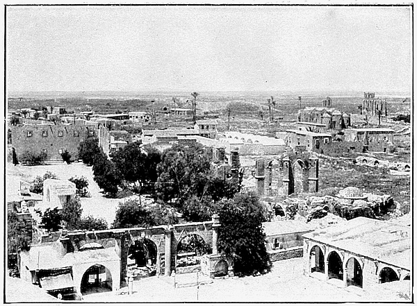
Copyright.]
[See page 25.
Famagusta.
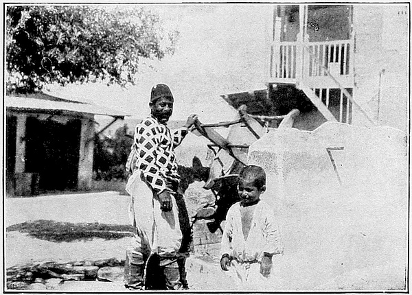
Copyright.]
[See page 27.
A Turkish Villager.
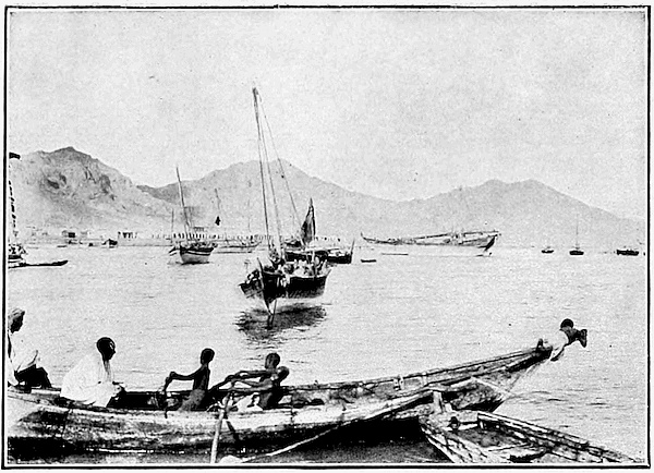
Copyright.]
[See page 34.
Arab Boats, Aden.
Copyright.]
[See page 37.
Camel Market, Aden.
We have no ports of call on these desert coasts, so 46 make straight for the exit into the Gulf of Aden and the wide Indian Ocean. As we near the southern end of the Sea, the water grows shallower, its shores approach again, and we can see bare brown rock on either hand, which makes the blazing sun seem even hotter than before. On our left, off a jutting corner of the Arabian coast, lies a low bare island, Perim. It is without vegetation or water, its sole virtue consisting in a deep harbour, commanding the narrowest part of the outlet, where the channel is only about twelve miles across. We occupied it as a precaution, fifty years ago, and it is now a coaling and cable station, with a small military guard. But it is without fortifications, and in spite of its position it is not the real key to the Red Sea; we must look for this in Aden, a hundred miles further east, just as we found in Gibraltar the control of the strait to the westward.
Aden.
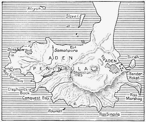
Aden proper is a small peninsula, five miles by three, 47 lying across a narrow isthmus which links it with the mainland. Thus it is not unlike Gibraltar; but one end of the peninsula, instead of jutting into the open sea, stretches westward towards another peninsula, that of Little Aden, which helps to enclose a large bay. Little Aden, the coastline and the mainland for a short distance inland were all obtained by purchase during the latter part of the nineteenth century; and the whole of the country behind, south of a line drawn northeastward from the coast opposite Perim, is a British Sphere of Influence. North of the line is the territory of Turkey. Aden is thus made secure from hostile approach on the land side. If we imagine the area of Gibraltar to be extended all round the bay of Algeciras and inland to the hill country of Spain, the position of the two fortresses would closely correspond.
As we steam towards it, Aden appears as a rugged mass 48 of dark rock, ending in sharp edges and peaks. Along its base runs a narrow strip of level ground, and a row of mean-looking houses faces the bay and shows white against a dark and bare background. There are no trees or vegetation to relieve the gloomy monotony. Here we 49 are at anchor, well out, off Steamer Point, as much of the inner bay is shallow. At once we are surrounded by 50 small boats manned by dark-skinned Somalis from Africa, and bringing a mixed crowd of all races eager to sell us tourists’ souvenirs, skins, horns and feathers, also the product of Africa. Here too are more coaling barges as at Port Said. We land and find that the near view is hardly more attractive than the distant; but this is only an outlying suburb of the real Aden. Let us hire a carriage, as it is far too hot and dusty to walk. Our driver is a Somali, and the animal in the shafts a decayed-looking pony; while the vehicle itself threatens every 51 moment to collapse and leave us in the sandy road. We make our way along the Akaba and through the narrow 52 and rocky Main Pass to the old city. We have passed in our drive through the wall of an old crater and the town lies at the bottom, surrounded on all sides by the broken rim whose jagged edges we noticed from the sea. 53 Here is a general view of Aden from the heights above. The whole peninsula is merely the fragment of an extinct volcano. In the white town, with its straight streets, we meet Arabs, Somalis, Indians, Negroes, Greeks, Jews and British soldiers; their presence here, on a barren rock between the desert and the sea, can be understood only in the light of the past history of Aden.
Here, from the remotest antiquity, was without doubt a great port of exchange for the products of India, Arabia, Africa and the Mediterranean, by way of Egypt and the Nile. In the Middle Ages, when first we hear of it from travellers, Aden was still a strong and important city. The Portuguese, after their discovery of the Cape route to India, saw that the possession of Aden would complete their control of the Indian Ocean; but they failed in their efforts to capture it by open attack. The Turks held it for a time as part of the Yemen, the neighbouring southwest corner of Arabia; then it fell under the rule of various local chiefs or Sultans. So we found it in 1838, when we proposed to buy it from the reigning Sultan. The negotiations failed through treachery and outrages on the part of the natives; so in the following year an expedition from India took forcible possession. As a result of this, Aden is still technically a part of the Presidency of Bombay.
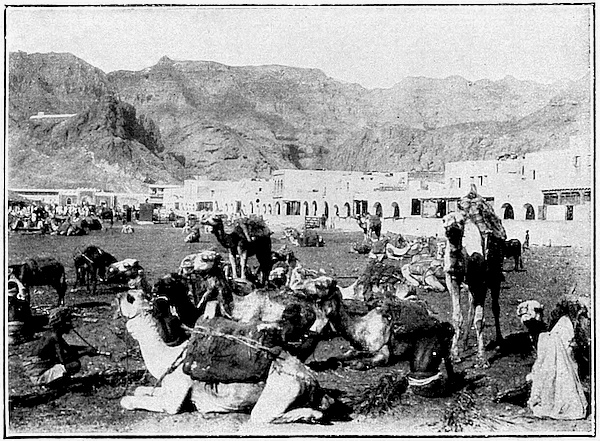
Aden has been occupied continuously for thousands of years, in spite of the fact that it has nothing whatever to recommend it except a harbour and a fine commercial and strategic position. The heat is intense; there is no food produced on the spot for man or beast, and very little water. In some years there is no rain at all; in others a few showers come from the Indian Ocean, with the Southwest Monsoon. The rain falls on the bare rock and runs swiftly away; the lower courses of the streams become rushing torrents for a few hours and then all is parched and dry again. More than a thousand years ago the Persians, who then ruled the city, built a series of huge tanks or reservoirs, often hewn out of the solid rock, to catch the flood-water. We can judge from their size and number that these tanks must have been built 54 to supply a large population. In course of time the tanks were allowed to fall into decay, but some, as we see here, 55 have been restored under British rule; and since the occupation of the district further inland, water has also been brought by aqueduct from the wells at the village of Sheik Othman. Sheik Othman is on the edge of the hills and far more healthy and pleasant than Aden. Here is 56 one of the wells with a camel drawing water, and here we have a typical scene in the village. The trees suggest at 57 once that the climate is different from that of Aden, and this part of the country is likely to be used more and more as a health resort for the troops of the garrison. In building the aqueduct we merely followed the example of earlier rulers, as the ruins of a similar aqueduct, centuries old, are still to be seen. The aqueduct is not enough; water is also brought in skins laden on the backs of camels, and is manufactured in condensers. In fact, water is perhaps the most rare and valuable commodity to be found in Aden. All food, too, must be imported; and here we must look not only to the back country of the Yemen, but across the sea to the neighbouring coast of Africa. Though some supplies are brought in by caravan from the country round, yet Aden could not exist without the regular shipments from Berbera and Zeila on the coast of Somaliland. There is also considerable traffic in coffee, ivory, feathers and skins from this coast, while native Somalis swarm in Aden. So that Aden, by the necessities of its existence, is closely linked with the neighbouring Horn of Africa. With no products of its own, it is a collecting centre for the trade of the coasts of Arabia and the Persian Gulf; while caravans can come in comparative safety from the Yemen country now that the British Sphere of Influence has been extended inland to the line drawn from Perim northeastward. The camel caravan is one of the ordinary sights of the town, and 58 here in the native quarter we see the market for camels, just as our English towns have their markets for horses and cattle. Many of the camels are shipped across to 59 Somaliland, where we shall follow them later; and it is interesting to see them hauled up in slings from barges to the steamer’s deck. The camels, however, do not seem to enjoy the experience.
Aden has had three stages in its history: first, a period of prosperity, in the earliest days of trade between the peoples of the Mediterranean and the East; then a period of partial decay, when the centres of trade were shifted to Western Europe and ships sailed round Africa to India and the East; finally, a revival of its former position as a commercial port of call on the restored Egyptian route, and in addition an ever-growing importance as a coaling point and centre of strategic control for the Indian Ocean. The population is increasing, like that of Gibraltar, beyond the capacity of the little peninsula; this has rendered necessary the expansion of territory inland. Even some of the troops of the garrison are now quartered beyond the isthmus. But expansion of area does not bring a corresponding growth in the supply of food for the cosmopolitan population. A prosperous Aden must in the future depend more and more on imported supplies, and this must involve still closer relations with the nearest source of supplies, the neighbouring coast of Africa.
The resources of Somaliland are not unlimited; while not Aden alone, but the whole Red Sea coast of Arabia is likely in the future to become more dependent on imported food. Let us look back for a moment at these shores, (46) before we leave the Red Sea for the open ocean. We remember that our mail steamer in its voyage found no port of call between Suez and Aden. So we drive along one of our own high roads to-day, with nothing to stop us, through open fields and uninhabited country; yet a few years hence we may find it lined with houses and shops, and with branch roads pouring their traffic into the main stream. It is possible that our sea-road may grow in the same way. Along the eastern shore the Turks are building a railway from Damascus to the sacred cities of Medina and Mecca; it has already reached Medina, and at sometime doubtless it will be continued southward to Hodeida and the towns of the Yemen. For pilgrims, the railway will make easier the journey to Mecca which every good Mohammedan strives to take once in his life. For the Government of Turkey it has another use: it will strengthen their control over the southern corner of Arabia, a control which is never too secure. The result must be more people and more trade on the coast strip of Arabia, and need for supplies of food greater than the neighbouring country can produce. We may see here in the future the problem of Aden on a large scale, and again we must look across the sea.
Jeddah is the port of Mecca; almost opposite Jeddah, on the African coast, is Port Sudan, the gate of the Anglo-Egyptian Sudan, and the terminus of the Sudan Government railway system, which crosses the desert to the Nile and opens up the country from Wadi Haifa in the north to Sennar in the southeast and El Obeid in the west. This great region, with its centre at Khartum, is entirely dependent for the bulk of its trade on the railway and the seaport. As this country develops, it may find a market for part of its products on the coast of Arabia, while the rest will join the main movement through the Canal to Europe. That portion of our high road which runs through the Mediterranean owes much of its importance to the active life of the neighbouring coasts; the Red Sea, by contrast, is a mere passage through the desert which separates Europe from Asia. But the railway is conquering the desert, and in the future this portion also of the chain between West and East will take some share in the busy traffic of the whole.