CONSTANTINOPLE.
Reading edition
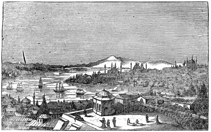
[View of Constantinople from Galata.]
This magnificent city, which, won from the degenerate Greeks of the lower empire, has been for four centuries the capital of the Turkish empire, is situated in 41° 1′ 27″ north latitude, and in 26° 35′ of east longitude.
The ground it occupies is marked out by nature as the site of a great city. A gently declining promontory, secured by narrow seas, at the east of Europe, stretches out to meet the continent of Asia, from which its extreme point is separated by so narrow a strait that in a quarter of an hour a boat can row from one continent to the other. This strait or channel, which is called the Bosphorus, running about fifteen miles from the Black Sea, between the beautiful shores of Europe and Asia, looks like a stately river, until it sweeps by the angle of Constantinople and enters the sea of Marmora. But just before it is lost in that sea, it makes a deep elbow to the right, flowing between the triangle of Constantinople Proper, and its suburbs of Galata and Pera, and forming the port which is called the Golden Horn. This is the most convenient as well as the most beautiful harbour in the world.
A city was built here by a colony of Lacedemonians as early as the year 660 before Christ, or about a century after the foundation of Rome; but this city only occupied the apex of the triangle, or precisely that space now within the enclosures of the Seraglio. It was called Byzantium. The present immense city, called Constantinopolis, or the city of Constantine, after its founder, was built about the year 330 of our era, by the Roman Emperor Constantine, who thought it the best place for the capital of the world.
The triangle which the city now entirely occupies is thus washed on one of its sides (the northern) by the deep waters of the port, and on the other (the south-eastern) by the sea of Marmora. The base of the triangle, or the ground immediately beyond the walls which attaches it to the European continent, is an open elevated flat, with some trifling inequalities of surface. The area of the triangle is occupied by gentle hills, which are highest towards the land side, and gradually decline to the Seraglio point, shelving off on either side to the sea of Marmora and the port. As Rome was built on seven hills, so the Roman founders of Constantinople called these “the seven hills,” though, in fact, if the principal chain only were counted there would be less, and if the minor hills or spurs were taken into the account, there would be more, than seven. On these hills the city stands, presenting on each of the three sides of the triangle the aspect of a stately amphitheatre. The ridge of the first hill, departing from the acute point of the triangle, is occupied by the Seraglio, or vast palace of the Sultan, behind which, a little on the reverse of the hill, the dome of Santa Sophia shows itself. The second hill is crowned by the mosque of the Osmanieh, whose dome is strikingly bold and lofty. The still grander mosque of Soliman the Magnificent towers on the third hill; whilst an ancient aqueduct, whose bold arches have the happiest effect, unites the summits of the third and fourth hills. On the very highest point of the chain there is a lofty tower, built within these few years by the present Sultan, in which a guard is constantly placed to watch the breaking out of fires, which are very frequent and destructive in a city where all the private habitations are built chiefly of wood. Few things are more calculated to make an impression on the mind of the stranger than when an accident of this sort occurs at the dead of night, and the immense drum is beaten at the top of the tower, and the voice of the guard is heard shouting, ‘Vangar’ (fire).
Though there is one principal street, which, with but 194few interruptions, traverses the city from the Seraglio to the inland walls, the houses of Constantinople are not generally massed together, but interspersed with open spaces, gardens, trees, ancient ruins, and isolated mosques,—the tall, slim, arrowy minarets or towers of which, all kept purely white, and tipped with a gilded crescent, contribute greatly to the beauty of the views.
The situation of Constantinople upon hills is not only the cause of its beauty, but of its salubrity and comparative cleanliness. It catches all the pleasant breezes from the Bosphorus, the Marmora, and the adjoining plains of Thrace; and the dirt that might accumulate naturally descends the hills’ sides to the port or the open sea, in both of which it is carried off by a strong current. To this advantage must be added the immense number of fountains and the quantity of flowing water which is always carrying off parts of the dirt; and the heavy rains which, when they fall, so wash the sides of the hills, that nothing can well be cleaner than the greater part of Constantinople at those seasons. Indeed, at any time, the lower edge of the city that touches the port, and the opposite suburb of Galata (the Wapping of the Turkish capital), may be called filthy places, but the term cannot be correctly applied to Constantinople as a whole.
Some ill-natured travellers have said that the only scavengers here are the unowned dogs which roam about in countless thousands; but we believe in all times there were a set of Turks employed to clean the streets, and the present sultan has certainly a regularly organized corps for that service.
Allowing for the empty spaces, which collectively would form a portion by no means inconsiderable, Constantinople occupies the whole of the natural triangle, whose outline is fringed by old walls flanked by towers. These walls and towers on the side of the sea of Marmora and the port, where in old times they were not required to be so strong, are now in a very ruinous state and, in some parts, on the Golden Horn, have entirely disappeared. But on the land side, where the defences of art were more called for, Constantinople presents a treble line of most formidable ancient walls which might easily be repaired; and which, in their more dilapidated parts, offer such magnificent and picturesque specimens of mural ruins as no other city can boast of. The length of this latter line of wall, from the head of the port to the Seven Towers on the sea of Marmora, is above four English miles. The form of the triangle, as may be seen by our little plan, is somewhat irregular, having the side from the Seven Towers to the Seraglio considerably the longest. According to the best calculations the population contained within these walls is about 500,000. If we add to this number, as is usually done, the population of the suburbs of Pera and Galata, of Scutari, which, though in Asia, is so near as to be considered a suburb, and of the numerous villages which closely succeed each other on both sides of the channel of the Bosphorus for several miles, we may arrive perhaps at the number of from 700,000 to 800,000 souls, comprising Turks, Greeks, Armenians, Jews, and Franks.
On whichever side you approach Constantinople,—whether ascending by the Dardanelles and the sea of Marmora, or descending from the Black Sea by the Bosphorus,—whether you arrive by crossing the plains of Thrace, or come in sight from the opposite hills of Asia,—she presents herself indeed like “the Queen of Cities.” The effect of the first view is almost magical.
The preceding sketch will give some idea of the beautiful outline of part of Constantinople. It is taken from the hill side, above Galata. Near this point was an old Genoese tower, burned down within these three years, from which the view of the city was of surpassing beauty.
[To be concluded in our next Number.]
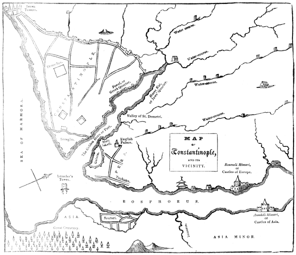
[MAP OF Constantinople, AND ITS VICINITY.]
195