LAKE DWELLINGS. PART II.
Reading edition
DESCRIPTION AND GEOGRAPHICAL DISTRIBUTION OF ALL KNOWN LACUSTRINE SITES IN IRELAND, WITH AN ACCOUNT OF THE ANTIQUITIES DISCOVERED IN OR AROUND THEM.
PROVINCE OF ULSTER.
COUNTY ANTRIM.
Lough Ravel (otherwise Derryhollagh).—This name is but a modern corruption of the ancient form, found in the Inquisition of 1605 to be in the district of the “Feenagh”:—“Est in eodem tuogh quidam lacus vocatus Loughdireare in quo est insula fortificata.” The site of this crannog, lying between Toomebridge and Randalstown, is known to the country people as “the island” in Aghaloughan bog; it seems to have been entirely artificial, constructed on oak piles driven into the bed of the lough, and bound together by horizontal beams of the same timber mortised to the piles. The interior was filled up with wood and earth, thus forming an island of about twenty-eight yards in diameter; and beyond this, at the distance of some six or eight yards, there still remain several oaken piles, probably traces of an outer stockade. On the crannog were stone hearths with marks of fire on them, and partially within the enclosure was a very perfect single-piece canoe of oak, twenty feet nine inches long, by four feet seven inches broad, the sides twenty inches deep. In the island and its immediate vicinity were querns, several wooden and copper dishes, daggers and spear-heads of bronze, iron celts, and stones with holes perforated in them; also some articles seemingly intended for ornamental purposes, and others of strange shape, regarding the use of which no conjecture can be formed. These “finds” have been sold from time to time to various collectors. At a short distance from the island, and twelve feet below the surface of the bog, was brought to light in the summer of 1856, a pan-shaped circular vessel of thin hammered copper, twenty-two inches in diameter, and eight inches in depth; it is now in the Belfast Museum, and a label attached to it states that a few years previously a similar one had been found nearer to the island; and in 1859 another vessel of small size, made of hammered copper, was discovered in the same locality. A bronze needle or bodkin, three inches long, with the eye quite perfect; a narrow iron hatchet, eight inches in length, and one and a-half inches wide at its cutting edge;[185] a bronze pin of unusual form, ornamented with two human heads (ante, p. 109, fig. 126); two bronze fibulæ (ante, p. 118, figs. 147 and 148); undressed flint flakes (ante, p. 58, figs. 12 and 13); the glass beads figured (ante, p. 124, figs. 168 and 169); and a beautifully designed silver brooch (ante, p. 121, fig. 157), were found in this crannog.[186]
Loughmagarry.—The townland of this name is in the parish of Craigs, barony of Toome lower; it contains within it a low-lying piece of land, the former bed of a lake that was drained towards the close of the last century. The present name bears no resemblance to its designation in the Inquisition of 1605,[187] but it has been identified as the same by Dr. Reeves; the large townland which adjoins it on the west, and of which it appears to have been formerly a sub-denomination, is called Feenagh. The Loughinchefeaghny of the deed of 1605 is a compound word, signifying—according to the above authority—“the lake of the island of Feenagh,” but perhaps may be interpreted the island of Fiodhnach, i. e. the wooded place. The crannog stood close to the shore of the lake near its western margin, where the bank rises abruptly from the hollow; it is now a mere gravelly knoll, but the country people recollected seeing it surrounded with an external framing of oak posts, the interior filled in with gravel and clay. Several curiosities (now dispersed) are said to have been found in it.[188]
Loughtamand, or Loughtarmin.—In the townland of Lisnahunshin, parish of Craigs, barony of Toome lower, and four miles N. W. of the village of Ahoghill, a crannog became apparent about 1849, when the lake was drained. According to the description given by labourers employed in the operations, a kind of framework, consisting of oaken beams in a good state of preservation, was discovered, entirely surrounding an island. Local tradition assigns this stronghold to the sept of the Mac Quillans, and being situated on the boundary of the districts of Dalaradia and Dalrieda, it afforded great security as a place of retreat, after marauding expeditions—a recommendation that in ancient times would render it a position of considerable importance. Its site was identified by Dr. Reeves as the “Loughtoman” mentioned in the Inquisition of 1605: “Est in eodem le tuogh quidam lacus sive stagnum vocatum Loughtoman in quo est insula fortificata.” The lough is bordered on the east and south by traces of bog, and enclosed on the north and west by hills three in number, from two of which the country slopes down with a regular fall to the river Bann. Between the hills on the north and north-west there is a considerable depression, and at this point a small stream flowed, carrying off the surface water, and which stream, being deepened, served as a drain for the lough. Before the withdrawal of its contents, about fifty acres were submerged, the water varying in depth from seven to ten feet. In the year 1820 the lough was drained by Lord O’Neil, but from after neglect the water once more accumulated in the hollow; it was, however, again drained, and is now under pasture. On the east side the banks of the bog which formed the margin were from twenty to thirty feet in perpendicular height, the outline of the basin being thus well defined; it was of irregular oval shape, and about a mile in circumference. The island itself, of circular form, and seventy yards in diameter, was situated almost in the centre, though somewhat nearer to the north and east sides; it was visible even before the drainage, and on it was a stone house. In the draining operations the main cut was carried across the long diameter of the lough from south-east to north-west, passing through the middle of the island, where the workmen came upon oak piles. These piles—from seventeen to twenty feet long, and from six to eight inches thick—were driven into the bed of the lough, and projected five or six feet above it; they were bound together at the top by horizontal oak beams, into which they were mortised and secured by stout wooden pegs. Above the top of these piles there was a depth of three or four feet of earth, and it was only when the earth had been removed from time to time that the wooden structure became apparent in its integrity. The piles—twenty-six in number—were arranged in a circle of about fifteen yards in diameter in the centre of the island, and just under where the stone house stood. It was stated that a few feet below the present surface of the bed of the lough a paved causeway of stone, about five feet broad, led from its western margin across to the island, which is now reduced to the level of the surrounding ground from the effects of cattle tramping over it, and persons digging down in search of treasure. The horizontal beams were removed and used for various purposes; the drain formed a tangent to the circle of piles touching it on the east, where some of them were dragged up on being laid bare. A single-piece oak canoe, in tolerable preservation, was discovered about thirty yards from the island on the north-west side, and from time to time the following articles were found in it: metal dishes; small axe-heads; two iron swords; a small anvil; a pair of scale; many small hammers; “several gold pins;” an iron cauldron of low dilated shape, and a stone yellowish-white in colour, beautifully polished, about twelve inches long, three and a-half inches broad, and two inches thick, accurately squared at the sides, having at each end a round hole one and a-quarter inches deep, and a-half inch in diameter, the top surface and one of the sides being covered with carved devices. Lord O’Neil obtained the swords; the anvil, scales, and hammers, were sold for trifling sums to an itinerant dealer; the iron cauldron was in use as a potato pot, and the polished stone was given by the finder to a friend as a “rubbing-stone” for his web.[189]
Kilknock.—In the Ulster Inquisition sped at Antrim on the 12th July, 1605, which still remains of record, it was found, amongst other things, by the jury, “Et quod est infra metas et bundas ejusdem le tuogh quoddam stagnum vocatum Loughernegilly in quo est insula fortificata.” Although that name is now obsolete, yet Dr. Reeves, after careful research, succeeded in identifying it with Kilknock lough situated in the north-west corner of Drummaul, in the townlands of Kilknock, Ballybollen, and Gillistown. In former times this lake covered fifty acres, but it was drained about the close of the last century: by this means the crannog was brought to light, and the oak piles on which it was constructed were exposed to view. It is described as of nearly circular shape, sixty feet in diameter, and on it were the remains of a wooden hut, constructed of oak beams; these timbers were removed, and some of them utilized as roofing material for a neighbouring barn. A canoe was found (at the same time) in the lough. Owing to a dispute, which afterwards arose, as to the ownership of the drained land, the outlets of the water were allowed to close up, and in consequence a considerable portion of the former lake had become again submerged. The island could be reached by wading, but was distinguishable from the rest of the marsh only by its greater firmness. Over the tops of the oak piles—said to be about two feet in diameter—was a considerable depth of soft boggy matter, and a paved causeway, covered eight or nine feet deep, led down to what used to be the edge of the water. The bog around the lake, thickly studded with trunks of oak, varying from one to three feet in diameter, prove it to have been at some remote period the site of an extensive wood.[190]
Randalstown.—The large crannog in this locality appears to have been formed with very heavy beams laid horizontally, but its condition when discovered must render any account of the original construction quite conjectural. The island is said to have been formerly occupied by a sub-chief of the O’Neils; the lake in which it stood was long since drained, and a peat-moss now occupies the place. Many articles discovered in this crannog are now dispersed; they would seem to have been of all ages, and to have been deposited at varying intervals of time: a stone hatchet of rather diminutive size, but in shape neither remarkable nor uncommon, was probably the most ancient relic, and the most modern was a base coin of Philip and Mary. The surrounding bog has yielded up not merely several fragments of canoes, but also some in an entire state. One of large size, and quite perfect, was (in 1860) exhumed from a depth of sixteen feet of peat: when first raised it retained its original shape, but from drying and atmospheric exposure it soon warped and became shapeless. The length of this canoe was about twenty feet by four feet wide at the stern, and three feet at the stem; from thence for about two-thirds of its length it was formed out of a single log, the stern end being composed of thick short planks well fastened with strong wooden pegs. In the bottom was a neatly made paddle of oak, three and a-half feet long (plate XXXIII., No. 3); beside it lay a wooden bowl that would contain about a quart; it had been hollowed out of a single piece of wood, and its sides were thick and rough (plate XXXIII., No. 5). Later on another canoe paddle of oak was discovered measuring three feet in length (plate XXXIV., No. 3). A good idea of the importance of this stronghold may be formed from the number of tools and appliances found in it for carrying on the ordinary business of every-day life, such as the tongs and supposed anvil of the smith—the latter a rough lump of iron somewhat smoothed on one side, and weighing fifty or sixty pounds—many crucibles, one unused, but several greatly worn and burnt, the most perfect specimen being about the size of a hen’s egg; a netting-needle of iron; a battle-axe, such as was borne by the ancient gallowglasses; a very small sock of a plough (plate XXXIII., Nos. 25, 6, 7, 8), and an iron lamp (plate XXXIV., No. 2).[191]
Ballymena.—At a distance of about four miles from this town, and near Cloughwater, the site of a crannog was discovered in the middle of a bog, formerly the basin of a lake, that had been filled up by peat, which had grown to such an extent as to entirely bury the island dwelling until laid bare by turf-cutters. Seemingly the crannog was not of great size, neither did it contain objects of special interest in themselves, their peculiarity being that instruments of iron and stone were found in company, also a bronze pin and several fragments of crucibles, together with remains of the fuel used. A pointed and socketed iron instrument (plate XXXIV., No. 1); two small flint knives; a stone celt; a round flat stone, two inches in diameter, having an oblong indentation on either side; and several pieces of rude pottery, bearing marks of fire, were amongst the articles brought to light.
Lough Guile.—In the parish of same name, and on the site of a crannog situated in a bog, are said to have been discovered two bronze knives, and with them a bronze instrument, six inches long and very sharp in the point (plate XXXIV., figs. 8 and 7); and on the same plate, fig. 6, is a flint knife, the form rather unusual: there were several of the articles commonly called “spindle-whorls,” some of lozenge shape, but most of them round; one was composed of jet, having indentations on it as for a thong or string. No description of the special formation of this crannog is recorded.[192]
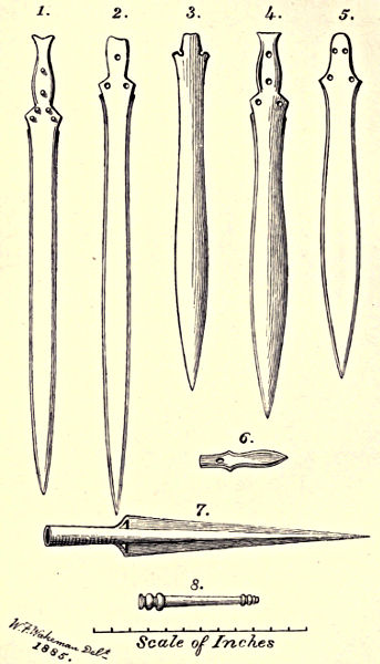
Plate XXXVII.
Bronze Weapons from Crannog sites on Toome Bar.
Toome Bar.—In 1864 Robert Day, junior, gave the following interesting description of sites of crannogs in this neighbourhood. The bridge which spans the river at Toome forms a connecting link between the counties Antrim and Derry. At this place Lough Neagh presents the appearance of a great V, having the space between the points filled with a sand-bank, known as Toome bar, and which is almost invariably covered with from two to three feet of water. Barton, who published a work on Lough Neagh in 1751, states that before the autumnal season the water discharged at Toome was so very inconsiderable as not to afford a depth greater than that which may reach to the ankle or the knee of a person wading, and that on one occasion a man, taking advantage of an inblowing wind, walked over dryshod. Strewn upon the bar, and imbedded in it, were logs and balks of timber, some bearing the marks of fire, while others still retained their upright position. They must have been placed there artificially, as the bar of sand extends a quarter of a mile into the lake, outside of which there is deep water, and if it were by the force of the water they had been thrown up, it is equally probable they would have been swept away by the first flood. From this it may be inferred that there was on the spot, at a very remote period, a crannog or lacustrine settlement. The large number of flint weapons found on the surface, or imbedded in the sandy bottom, renders it more than probable that they had been in use by the dwellers in this island village. Flint is not found within seven miles of Toome, so that it must have been carried to and manufactured in the crannog. The most conclusive proof of their having been made on the site was furnished by the presence of the large cores of flint from which the weapons had been struck. Two rudely-shaped, barbed spear-heads were here obtained, and four celts of the ordinary type, made from the trap rock, two of them polished, but the others were made with less care, the edge alone showing signs of careful working. Antiquities of great variety belonging to the stone and bronze periods were found at the time the river Bann was deepened; these were deposited in the Museum, R. I. A. All the good specimens, evidently designed for special purposes, and to which had been given certain and definite shapes, were made out of rocks characterised by possession of all the essential qualities needful for such articles; whilst the rude, ill-formed implements were composed of shale, slate, schist, grit, or any other stone which presented itself within reach. The greater number of the flint weapons were formed by not more, probably, than three or four skilful strokes, thus: one would strike the fragment from the core, two more would form the mid-rib giving it a leaf-shape, and a fourth stroke would cause the slight depression at the base intended to secure the weapon to its shaft or handle. These opaque flint flakes, of the largest size and honey yellow in colour, were found six feet under the bed of the river Bann, lying with several others and a stone celt “in one mass on the old or former gravel-bed of the river, not far from Toome Castle, on the county Antrim side.” At Toome were found also the bronze weapons figured plate XXXVII., in which No. 1 represents a sword in a perfect state, having the point worked down below the level of the blade, for about four inches; it has a broad handle-plate, cleft for pommel, with six rivets still in position; it is 25⅜ inches long and 1⅛ broad. No. 2 is a complete blade, but the handle-plate is defective; it is brazed in two places, only half an inch asunder, the line of junction being scarcely discernible; it is bevel-edged, has hilt notches, four rivet-holes, and is 26½ inches long, by 1¼ broad. No. 3 is a plain blade, slightly corroded, and wanting part of handle; its length is 19¼ inches, by 1¾ broad. No. 4, ibid., perfect, feather-edged, slight hilt notch, four rivet-holes in handle-plate, 21 inches long, by 1⅜ broad. No. 5 is a leaf-shaped blade, 19 inches long and 1⅞ wide at broadest part: this weapon is from the crannog of Bohermeen, county Meath, and is here given for purpose of comparison. No. 6 is a perfect knife-shaped dagger, grooved in casting; slight raised notch on handle-plate, and 4¾ inches in length. No. 7 is a perfect specimen of the long narrow spear-head; it has straight edges, loops at angle of slender socket, broad bevelled edges, and is 16¼ inches long, by 2 in. broad at base. No. 8 is a thick, short, cast bronze spear-handle, with bulbous extremities, 6¾ inches long, and it “still contains a fragment of the ancient shaft.” This relic points to a close intercourse between the north of Ireland and Scotland, for in their wars against the Romans, A.D. 208, the Caledonians had, amongst other weapons of offence, a spear of peculiar construction, “having a brazen knob at the end of the shaft, which they shook to terrify their enemies.”[193]
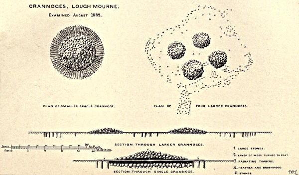
Plate XXXVIII.
CRANNOGES, LOUGH MOURNE.
Examined August 1882.
PLAN OF SMALLER SINGLE CRANNOGE.
PLAN OF FOUR LARGER CRANNOGES.
SECTION THROUGH LARGER CRANNOGES.
SECTION THROUGH SINGLE CRANNOGE.
1. LARGE STONES.
2. LAYER OF MOSS TURNED TO PEAT.
3. RADIATING TIMBERS.
4. HEATHER AND BRUSHWOOD.
5. STONES.
Lough Mourne.—The waters of this small lake, situated upon a hill about 600 feet above the level of the sea, and three miles due W. of Carrickfergus, were temporarily drained off in the summer of 1882, to enable the engineers of the water-works to carry on their operations; and, when the level of the lake had been lowered ten feet, a number of artificial islands were exposed to view. There was a group of crannogs consisting of four islets erected on one common pile foundation, and at some little distance there was a solitary crannog. The group was formed of some hundreds of piles, four or five inches in diameter, with a cross timbering of branches of various sizes upon a thick layer of heather and moss. Upon this the four islets were built of boulder-stones to form the floors of the wooden houses … the piles generally retained their bark, and were mostly of pine, willow, and ash, with occasionally some of oak; they were rudely pointed on one side only. Many of the stones bore traces of fire, and had evidently formed part of the hearth; a piled causeway, one hundred yards long, led part of the way to the shore; the interior was filled with heather and moss. The single crannog lay somewhat farther from the shore, and in deeper water than the others; greater skill, too, appears to have been displayed in its construction. The lowest course (see section, plate XXXVIII.) was composed of large stones, whose exact depth could not be ascertained owing to a strong spring of water which flowed up between them; upon this was a layer, two feet thick, of moss, which time and pressure had converted into peat. Upon the moss were radiating timbers, the outer ends of which rested on and were notched or mortised into piles disposed in several rings round the island; these piles and cross timbers were larger than in the composite crannog, and many of them were of oak. Upon the timbers was a layer of heather and brushwood, upon which rested the stones forming the floor of the hut: in this case there was no causeway to the land. The relics discovered were not numerous, but the soft, almost liquid nature of the mud rendered a thorough search almost impossible. There was found about five feet of the prow of a “dug out,” and, in addition to charcoal and bones in considerable quantity, there were two small stone crucibles, calcined flint flakes, several fossil sea urchins from the chalk, worn smooth by having been carried about as ornaments or charms; a small stone with a hole in it—possibly also a charm—and a pair of “rubbing-stones.”[194] In midsummer, 1884, a very fine canoe of oak, found entire in the bed of this lake, was presented to the Field Club by the Water Commissioners, and has been by them lodged in the Belfast Museum. This canoe appears to have been shaped chiefly by the axe; it is hollowed out of a single trunk, is twelve feet eight inches in length, and two feet six inches in width, the inside depth being nine inches—the same breadth continues throughout—the bottom of the canoe is perforated with six rather cleanly cut round holes, about three quarters of an inch in diameter.

Fig. 198.—Dug-out Canoe found near the Crannog of Lough Mourne.
Lisnacroghera crannog lies at a little distance from Broughshane, in the parish of Skerry, barony of Antrim. About the year 1882, workmen employed in cutting turf—bared by the partial drainage of the lough—came upon oaken timbers laid in regular order; unfortunately nearly all were removed before anyone acquainted with the peculiarities of crannog structure had seen them, and in the autumn of 1883, most of the timbers had disappeared, though a few of the encircling piles remained in position. Some remarkable antiquities, discovered either within or around it, have been rescued from oblivion and destruction. A spear with iron head and butt, and rivets of bronze, and the iron sword-blades enclosed in sheaths of bronze (which are now in Canon Grainger’s museum), seem to call for prominent notice. With regard to these the Rev. James Graves says:—“It cannot be denied that this crannog find is one of the most important and valuable yet recorded in Ireland, especially in its bearing on the style and the chronology of the art of that early period when the bronze and iron eras overlapped. The spears have bronze butts, with terminal iron heads, for such were discovered in the crannog, whilst no spear-heads of bronze—an imperishable metal—were found. The bronze rivets remained in the shafts by which the iron heads had been secured. All this reminded one of the ninth century legend of the armourers of the Tuatha dé Danann when preparing for battle with the Fomorians at the northern Moytura. The mode of workmanship is graphically described:—Goibniu at his forge finishes the spear-heads in three hammer-strokes (probably they went through three processes in their fabrication); so it was also with the work of Luchtiné on the ashen spear-shafts, and Creidné on the bronze rivets. When Goibniu had finished the iron lance-head, he seized it with his pincers and sent it quivering into the door-post. Then Luchtiné launched the finished shaft so surely aimed that it found the socket of the lance-head, and penetrating to the bottom was firmly fixed there: whilst Creidné instantly flung from his pincers the finished bronze rivet with so sure and true an aim that it entered the rivet-holes to the required depth, and so the weapon was completed (Three Irish Glossaries, p. 32, Sanas Cormaic, p. 123). Hence, without assuming that the bronze-iron age should be thrown back to the mythic period of the Tuatha dé Danann and the Fomorians, it is evident that in the ninth century there was a tradition of its characteristics and existence in Ireland, and that of so remote a date as to suit the myth of the contest of the gods of light and life with the deities of darkness and death. The fashion of the spears, of the swords, and of their sheaths, prevailing at this early period, when the use of bronze and iron overlapped, has been hitherto but sparingly revealed to us by finds of weapons in England, Scotland, and Scandinavia. Kemble, in his Horæ Ferales, engraves several examples of short swords or daggers, the fashion of which is identical with that now for the first time so clearly shown us by the Lisnacroghera crannog find.” Professor Anderson, in his Rhind Lectures, has recorded the discovery of a bronze spear-butt, exactly similar, in one of the brochs of Scotland; it is correlated by him with the pagan iron age; and in a recent number of the Proceedings of the Royal Society of Antiquaries of Denmark there is engraved an iron sword-blade, with bronze haft-mountings, nearly identical in form and fashion with those discovered at Lisnacroghera.[195]
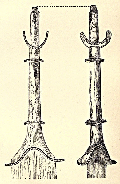
Plate XXXIX.
Haft of Iron Sword, with Bronze Mountings, from Lisnacroghera. Full size.
The antiquities found in this crannog consisted of a plain bronze sheath (plate XII., fig. 1), containing an iron sword (p. 61, fig. 17): the haft is represented full size (plate XXXIX.). One side of ornamented sheath slightly smaller than the former (plate 12, fig. 2): a full-sized representation is given (plate XL.).
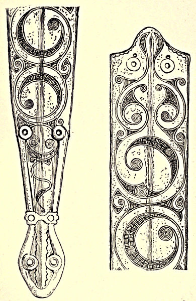
Plate XL.
Upper and lower portions of side of the Bronze Sheath, from Lisnacroghera, full size, of which a half-size representation is given, Plate XII. fig. 2.
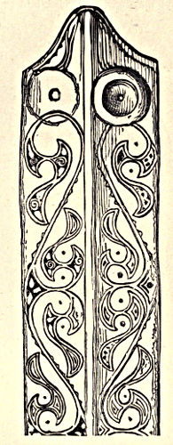
Fig. 199.—Upper portion of Bronze Sheath. Full-size.
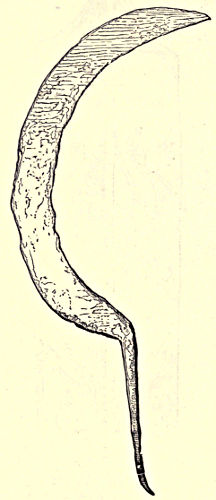
Fig. 200.—Iron Sickle. Eleven inches from point of blade to end of tang.
Another ornamented bronze sheath (plate XII., fig. 3), of which the upper portion is here given, full size. A sword of iron with bronze fittings to the handle: this is not the sword to which the sheath belongs. An iron sickle that had been affixed to its handle by a tang; their usual length was twelve inches—occasionally much smaller—and they may be divided into two classes, bronze and iron. Sickles of iron have been found amongst Roman and Saxon remains in Britain. A spear-head of iron (ante, plate X.). An iron adze (ante, p. 69, fig. 31), and some miscellaneous objects of the same metal (ante, p. 68, figs. 28 to 30). Six butt-ends of spear-shafts formed of bronze: five of these are represented (p. 64, figs. 19 to 23); the sixth is here given (fig. 201). Boss-like objects (six in number) and rings of bronze, supposed to be fragments of defensive armour (plate XV.). A bronze rivet (ante, p. 119, fig. 152). Two hollow penannular rings of bronze (ante, p. 119, fig. 150). An article composed of bronze, probably an amulet (ante, p. 116, fig. 145). An object in bronze, richly decorated (ante, p. 67, fig. 26). Three circlets of bronze (ante, p. 119, figs. 153-5). A small loop of bronze (ante, p. 109, fig. 135). A disc composed of thin bronze (ante, p. 72, fig. 34). A small boss or stud of bronze (ante, p. 119, fig. 151). Portion of an amulet of jet. Three beads of glass (ante, p. 124, figs. 165-7).
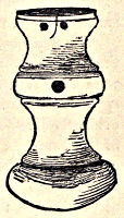
Fig. 201.—Bronze Butt of Spear-shaft. Two-thirds natural size.
Craigywarren.—Ante, p. 110.
Loughavarra.—Ante, p. 153.
Lough Lynch.—Ante, p. 153.
Lough Crannagh (or Lough-na-crannagh).—Ante, p. 28.—Amongst the scientific grants for the year 1885, recommended by the Council, R.I.A., appears the following;—“£20 to Mr. Alexander M’Henry for a report on the animal and other remains found in the sand-hills of Ballintoy and the crannog of Lough-na-crannagh.”
Lough Ronel is a name set down in the MS. register of Irish crannog objects, &c., British Museum. It is most probably an incorrect designation for Lough Ravel.
COUNTY DOWN.
During the working of the Commission for the Arterial Drainage of Ireland, a crannog—no name given—was discovered in this county, and traces of another at Ardbrin (ante, pp. 126-8).
Ballykinler.—In 1860 this crannog was no longer traceable, but fortunately a short description of it had been previously given. The section made through its centre showed it to be of the usual construction—surrounded by a circle of small piles, driven deep into the mud, and secured by cross-beams firmly mortised together, the space so enclosed filled with brushwood, on which was placed a layer of gravel and earth, that process being repeated until the surface became perfectly solid.[196]
Lough Faughan, or Falcon, in the barony of Lecale.—About the year 1845 a crannog was discovered in this lake. “There were large stakes driven into the ground, completely enclosing the space within, and not rising above the surface as a palisade, but evidently for the purpose of keeping in the soil from encroachment of the water. The tradition respecting it is, that there had been a castle on the shore opposite, the chieftain of which caused this island to be made as a place of refuge from the sudden onslaughts of the O’Neils; and to render this retreat more secure he would never allow more than one boat or canoe on the lake.” During drainage operations a “dug-out” of oak was found near this crannog, from which locality were also procured two earthen pitchers (ante, p. 92, fig. 66).
Ballywoolen.—This crannog was entire when seen in 1860, in a lake surrounded by hills, the surface of the island nearly level with the water. At one spot there was a flagging of flat stones where the hearth had been, and near it lay a quern.[197] The discoverer states the site of this crannog to be in the county Down; but the only townland in Ireland named Ballywoolen, is set down in the Ordnance Survey as situated in the parish of Dunboe, barony of Coleraine, county Derry.
COUNTY ARMAGH.
Camlough has a crannog at its north end.
Marlacoo Lough, near Armagh, has another.
Lough Ross, near Crossmaglen, also contains one, stated to have been the place of meeting of the Irish leaders in 1641.[198]
COUNTY TYRONE.
During the working of the Commission for the Arterial Drainage of Ireland, a crannog was discovered in this county, but its exact locality was not defined.
Corcreevy (alias Loch-Laoghaire), by which latter name it is mentioned in the Annals (ante, pp. 155-6).—The site was examined and the following articles brought to light: a pair of bronze and iron manacles; a double comb of bone in a perfect state, length 3 inches, and breadth 2⅜ inches, and having a brass ring attached to one extremity—it is now in the Museum, R.I.A.; parts of a musical instrument; an arrow-head; a spear-head; a sling, or hammer-stone.[199]
Cranny townland in this county possibly derives its name from having been the former site of a lake dwelling.
Clogherny, in the parish of this name, in the barony of East Omagh. The Rev. R. V. Dixon, D.D., thus notices the discovery of a crannog situated in a bog on the borders of the townland of Roscavey. About eight or ten feet below the surface turf-cutters laid bare the tops of a row of oaken planks which described a circle about seventy feet in diameter. These planks were from eight inches to fourteen inches in width, and from three inches to five inches in thickness, roughly split from the log, the lower extremities pointed and driven ten or twelve inches into the ground; their tops were all decayed; the length of the remaining part was about four feet. Each plank was pierced by a square hole, bearing marks of having been made by a blunt tool, and this orifice was narrower at the centre than at the edges. The planks forming the enclosure were placed edge to edge, and several rough logs of alder and birch, from two inches to four inches in diameter, were laid horizontally against the lower part of the planks on the inside of the enclosure, which was floored with oak, and underneath was about two feet of peat. Between the oaken floor and the outer fence were several flag-stones, evidently the old hearths, as shown by the quantity of charred wood that was about them. Southward two square posts were found. This crannog lay in a depression running nearly E. and W. between two sloping hills. “The fall of this hollow is towards the east, where it spreads out and sinks into a large basin, or glen, closed by rising ground of considerable height to the north and east; by a gravel ridge, or ‘esker,’ on the south; and opening on the west into the hollow in which the crannog stood. A considerable mountain stream enters this basin from the east, and after flowing round a conical gravel hill (connected with the esker) which stands in the middle of it, escapes through a deep natural cut or gap in the esker which, as before mentioned, closes the basin on the south. If this cut were closed, the basin would be filled up by the stream which now flows through it, and the level of the water would probably rise sufficiently high to fill the hollow in which the crannog stood, and this hollow would then form a shallow arm of the lake.”[200]
Galbally.—Ante, p. 60, plate VII.
Roughan.—Ante, p. 88.
COUNTY DONEGAL.
Crannog-boy, parish of Inishkeel, barony of Banagh.—Ante, p. 28.
Mongavlin, parish of Taughboyne, barony of Raphoe.—Ante, p. 151.
Lough Veagh.—Ante, p. 154.
Drumkelin, or Drumkeelin, parish of Inver, barony of Banagh.—The account of the crannog-hut here exhumed is given, ante, pp. 39-41.
COUNTY DERRY.
Inishrush.—Ante, p. 152.
Loughshillen.—Ante, pp. 148-9.
Loughan Island.—Ante, pp. 153 and 155.—Six stone celts, two bronze celts, three fibulæ, a bridle-bit, two bronze cheek-pieces (ante, pp. 136-7), an iron spear-head and spike,[201] were found here, and are now in the Museum, R.I.A.
Fort Lough occupies nearly the centre of an extensive bog on the right-hand side of one of the roads leading from St. Johnstown to Burt on Lough Swilly. It is described as about one mile long, and a quarter wide, but was formerly of much greater extent. There was a tradition that formerly a castle erected in the centre of this lake had been submerged by the neglect of a girl in not carefully re-covering a fairy fountain in the vaults, and consequently the waters burst forth in a raging torrent! After drainage operations, when the level of the lough subsided, marks of an island became visible in the centre, and by degrees stonework was observed rising above the surface, proving that the subaquatic castle was not altogether mere visionary fiction. These walls were found supporting a deposit of peat.[202]
COUNTY FERMANAGH.
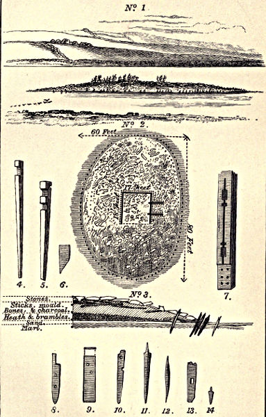
Plate XLI.
ELEVATION, PLAN, SECTION and DETAILS of the BALLYDOOLOUGH CRANNOG, Co. FERMANAGH.
W.F. Wakeman, 1870.
Ballydoolough (the place of the dark lake) is five miles distant from the town of Enniskillen; the expanse of water covers not more than twenty-four acres, and even during times of flood never exceeds twenty feet in depth; at the bottom could be discerned remains of a primæval forest. In June, 1870, from the effect either of drainage or of long-continued drought, a small island became apparent, on which were found fragments of fictile ware, and this led to a careful examination being made. Near the centre was an oaken beam, fifteen feet seven inches long, having evidently formed portion of one side of the lower framework of a dwelling. It was grooved throughout its entire length (plate XLI., No. 7), and had two holes—measuring nine inches by six—that were plainly intended for the reception of upright posts, to which the sheeting or side-boards of the structure were attached. Several oaken slabs, grooved at the sides (plate XLI., No. 9), were discovered in close proximity buried in the sand and mud. Upon clearing the foundation, the framework of the house was shown to be composed of well-squared beams of oak, grooved for the reception of planks, and mortised for the insertion of uprights, the angles dovetailed together, and fastened with wooden pins. The beam forming the eastern foundation of the house rested upon two blocks of dressed oak that projected from it at a right-angle to a distance of seven feet (plate XLI., No. 2), and this foundation may perhaps have supported a landing-stage. The lowest timbers of house and projecting beams were secured in position externally and internally by a row of wooden pegs, or small stakes, which enclosed the entire foundation, and rested against it on the exterior (on the plan these are indicated by a dotted line); the south-western angle of the house was strengthened by a flat block (No. 6). Of the upper work of the edifice no description can be attempted, though several dressed boards (Nos. 4, 5, 8, 9, 10, 13, on a scale of ⅛ inch to a foot), that had evidently formed part of the structure, were found scattered about.[203] On the western side of the island, being the one most exposed to the action of the water, the stakes were in greatest number, placed four, and at one point even five, feet deep. In some instances their upper extremities had been inserted in holes cut for their reception in beams of oak laid horizontally, and although only one such beam was found still in situ, yet an inhabitant of the locality stated that within his memory many of the horizontal timbers could be seen actually resting upon the stakes or piles, just below the surface of the water. The kitchen-midden of the dwelling contained a considerable quantity of bones, intermixed with numerous fragments of pottery. A selection of the bones having been forwarded to Professor Richard Owen for analysis, he pronounced them to be parts of Bos longifrons, Cervus elephas, Sus scrofa, and Equus asinus. In a more or less restored form, characteristic specimens of the pottery are figured (ante, pp. 92, 95, 96, 97). There were not many articles of bronze, but mention may be made of a plate of that metal, oblong in form, about as thick as a sixpenny-piece, and measuring five and a-half inches in length, by four and a-half inches in breadth; it retained a number of rivets, and appeared like a patch off some pan or dish. In Ireland the majority of cauldrons or dishes composed of thin golden bronze are usually found to have been carefully mended. Of wood, a vessel was discovered in an entire state, but from long saturation reduced almost to a pulp (ante, p. 102, fig. 103); and there was a small oaken vessel formed with staves. There were also balls of stone, varying in size from that of an orange to a walnut; several querns, and the inscribed stone described and figured (ante, p. 134).[204]
Coolyermer is the name of a lake four miles from Enniskillen, in the direction of Letterbreen; it contains an island which seemed to be composed entirely of oaken beams; the water, however, was too high to admit of an examination being made.
Drumdarragh, otherwise Trillick, has been recently thoroughly examined by W. F. Wakeman, whose report, accompanied by numerous drawings of remains discovered within the crannog, is prepared for publication in the Journal of the Royal Hist. and Arch. Association of Ireland. To the Museum of that Society the Earl of Enniskillen, in 1875, presented an oak paddle found at Drumdarragh crannog, in company with a single-tree canoe that had been unfortunately destroyed.[205]
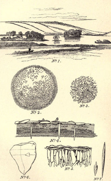
Plate XLII.
DRUMGAY CRANNOGS
W. F. Wakeman, 1870.
Drumgay (the ridge of the geese) lies nearly four miles to the north of the town of Enniskillen, and separated from the northern shore of Lough Erne by a narrow belt of land. This sheet of water is completely land-locked; there are in it three islets, and the south-eastern shore has a projecting point of artificial construction that becomes an island owing to the rise of water in winter time. Plate XLII., No. 1, conveys an excellent idea of the general aspect of the lake, and of the position of the islands; the large wooded one, situated near the centre, and now known as “Bone Island”—although its older appellation appears to have been “Cherry Island”—is constructed of beams of oak, ash, and pine, laid in rough blocks, radiating from a centre to the edge of a circle formed of stakes set in the ground, the diameter from north to south being one hundred and five feet, but from east to west a few feet less (plate XLII., No. 2). When the lake is at summer level the encircling piles are plainly visible; they had been roughly trimmed with an instrument of metal; the longitudinal cuts measured nearly a foot, and some of the piles were of oak (plate XLII., No. 7); they had no slope outward, and only at a few points did the rough wood and small branches usually interwoven with them still remain in position. From a point near the centre of the crannog, in a direct line to the eastern shore, a trench was dug; it commenced in the centre, was cut outwards to the water’s edge, and thus prevented sudden flooding; a similar trench was subsequently made on the opposite shore. As the result of these excavations, a very distinct idea of the internal construction of the work was obtained (plate XLII., No. 4). The old crannog-builders appear to have selected a natural shoal in the lough as the scene of their operations. This shoal consisted of marl covered by a streak of whitish sand about four inches in depth; over the sand, to a height of six or eight inches, was a stratum of yellowish clay, which supported unhewn logs of oak and birch, together with an immense quantity of small branches, twigs, brambles, and small pebbles, all compressed into a peat-like mass about two feet thick; this was covered by two feet of earth, containing here and there layers of burnt clay and bones; the clay was mixed throughout with bones of animals greatly broken, articles of early manufacture, slag or dross iron, charcoal, and rough stones. The surface of the island was in many parts covered with flat stones of considerable size, and stakes larger than those which formed the outer circle, yet of the same character, were found here and there, even in the highest and most central parts; they were designed to stay and prop the work, for their points were deeply imbedded in the marl which formed the bottom of the lough. It was impossible to procure any perfect specimen of these supports, as the wood, softened by saturation, broke off on application of the slightest pressure. Scattered amongst the bones that lay upon the shore of the island, were several fragments of earthen vessels; the one represented (ante, p. 93) was found here. Although search was made, yet comparatively few antiques were brought to light.[206]
In plate XLII. a large island is represented to the extreme left; this is what may be termed a composite crannog. The body of the island, formed entirely of stones, was formerly surrounded by rows of oaken stakes; none, however, are now to be seen; they served as fuel to a man who lived on the shores of the lake. The greatest height of this island above summer level of the water was about five feet, the form an irregular oval, two hundred and seventy feet in length, by one hundred and thirty-eight feet in breadth, and a trench cut through to a depth of five feet reached what seemed to have been the ancient bottom of the lake. The great peculiarity of this structure is that the collection of small flat sandstones of which it was composed had been placed on edge (plate XLII., No. 5). By the country people it is appropriately styled “the quarry.” Close to the north-western extremity of the lake may be seen a small crannog—about thirty feet in diameter—that is all but submerged even in the dryest season; the few oaken timbers that remain seem to radiate from a common centre, and are intermixed with stones, as shown in plate XLII., No. 3. Evidently this islet had originally been strongly staked. The fourth and last crannog is represented at the extreme right of the general view of the lake; but here the crannog wrecker had been at work, and the stakes that formerly entirely surrounded it were pulled up and used as fuel. A curiously sculptured stone (ante, p. 90) was discovered here. The last two crannogs lay at a very low level, owing perhaps to the fact of an unusual quantity of boughs and compressible matter having been used in their construction. Portion of a single-tree canoe of oak was found in the lake, as also two very neatly formed paddles of oak, measuring about two and a-half feet in length.[207]
Gortalough (the field of the lake) is situated near Drumgay, and within three miles of Enniskillen. Here a log-house, or crannog-hut was discovered buried under many feet of peat, but no trace of it now remains.[208]
Drumskimly, near Derrygonnelly.—In this lake, now almost drained, there were formerly two crannogs that are in the present day dry and under cultivation; but there remained a little island surrounded by water and well palisaded in the usual manner; it was circular in form, and about thirty-five feet in diameter; its surface has been converted into a garden. From time to time were here disinterred a spear-head and arrow-head, both of iron; a pair of quern-stones, and many fragments of pottery; one of the latter is figured (ante, p. 100).[209]
Drumsloe.—See ante, pp. 87-88.
Ballaghmore is the name now applied to a lake (about a mile and a-half from Enniskillen) in which was a crannog seemingly composed entirely of earth and stones, in a soft depth of mud, surrounded with a mass of aqueous vegetation. No piles were visible.
Moinenoe (the bog of the yew) is a locality about a mile from Enniskillen, and sometimes called Chanter Hill. It was the former site of a lake which now in summer becomes a soft and treacherous swamp, and such traces of the crannog as yet remain would be difficult to explore. A single-tree canoe was found in the bed of the ancient lough.
Breagho (wolf-field).—Near a place of this name labourers when cutting turf came upon a stockaded enclosure buried some twelve or fourteen feet below the then surface of the bog; the crannog was circular, and about thirty-five feet in diameter. A pair of quern-stones, a large oaken, bowl-shaped vessel, split in several places, and the sawn and perforated bones of a Megaceros hibernicus, were the only “finds” recorded.
Aughlish.—In a lake so called, about five miles from Enniskillen, in the direction of Boho, there is a crannog, but the height of the water precluded an examination. The tops of numerous piles are frequently visible in summer-time.
Killynure (the wood of the yews) is a small lakelet, distant a mile from Enniskillen, on the Tempo road. It contains a crannog which is usually flooded.
Lough Acrussel is situated near Enniskillen. The crannog was found standing in deep water; but after a continuance of dry weather the piling all around could be distinctly seen, and the posts were, as a rule, connected by horizontal beams. Near the centre of the island there was a large flag-stone that had evidently been used as a hearth. Upon sinking shallow trenches through portions of the work, bones and teeth of animals of the usual character were discovered, as also iron slag, wood charcoal in small quantities, and some thin pieces of bronze, seemingly parts of a cauldron or dish. The plan of the crannog was nearly a perfect circle, and its diameter sixty feet.[210]
Lough Yoan.—In the summer of 1883, the crannog in this lake was visited by W. F. Wakeman, who reported that its surface seemed covered with bones of various animals, the larger of them having been broken apparently for extraction of the marrow. There were several whetstones and fragments of querns; but no traces of woodwork remained visible, though possibly by digging through the sand and stones, of which the shoal is chiefly composed, some discoveries might be made.
Lankhill.—In this lake, situated near Enniskillen, a crannog was discovered by W. F. Wakeman, by whom it will be described in a forthcoming number of the Journal Royal Hist. and Arch. Association of Ireland.
Lough Macnean contains four islets, the one lying close to the western shore being appropriately designated “Crannog Island.” Its diameter is about sixty-four feet, and the work, which consists of a cairn of stones—rising to a height of eight or ten feet above the winter level of the water—had been formerly enclosed by a double row of piles composed of oak, yew, and pine. The usual amount of bones, a couple of fragments of pottery, and a large quantity of iron slag and charcoal, alone were discovered, although the shore was carefully searched. The island situated near Belcoo was of the same dimensions and formation; nothing but bones, slag, and charcoal, were found in it. In the crannog at the southern extremity of the lake, digging had to be discontinued in consequence of the percolation of the water. Much of the piling was still visible, although everywhere reduced to a state of pulp. The fourth islet, named Inishee (i. e. fairy island), yielded nothing; it was of natural formation.[211]
Lenaghan.—Here, about three miles from Enniskillen, is a small lake containing a crannog. On it were found immense numbers of animal bones, as also some few antiquities; one of them, a dagger of bone, measured fourteen inches in length.
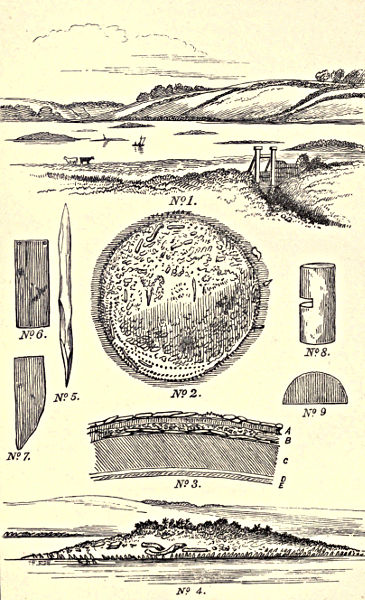
Plate XLIII.
LOUGH EYES CRANNOGS.
Plate 1. W. F. Wakeman 1870.
Lough Eyes is situated two miles north-east of the village of Lisbellaw; it is about two-thirds of a mile long, by less than a quarter of a mile across at its greatest breadth. This lough was not known to possess any manner of interest, scenic or otherwise, except indeed for the disciples of Isaak Walton, who found it well stocked with scaly prey. The Irish name of the lake appears to have been lost, possibly corrupted, or perhaps translated, for near the southern shore a spring called Tobernasoul—“the well of the eyes”—still gives forth water forming a small rivulet that connects the well with the lake, so that in all probability this furnishes a clue to the modern name of the sheet of water. Lough Eyes, like the crannog retreats of Ballydoolough and Drumgay—distant respectively about three miles—was anciently embosomed in a dense primæval forest. The roots and portions of the stems of oak, pine, and alder, of immense size, remained in situ, and were in such close proximity that their foliage must have commingled and formed a canopy impervious to storm. The forest, however, has been “pared to the stump,” as may be seen from the sketch of the locality—taken from the south-east—which conveys a fair idea of the tout ensemble of the scene. In consequence of the exceptional dryness of the summer of 1870, the level of the water was greatly diminished, and the islands (six in number) became exposed to view (plate XLIII., No. 1). Although the elevation of the remains above the surface of the water was unequal, still the rows of piling by which the lake dwellings had been protected and enclosed were on about the same plane. The crannog that was situated in the deepest part of the lake would appear to have sunk, but its subsidence may be attributed to the perishable nature of its component parts—logs and branches. The other habitations were constructed upon shoals—in one instance upon a natural turf-bank artificially strengthened, and then raised to the required height with layers of sticks, brambles, earth, and stones. Plate XLIII., Nos. 2, 3, 4, give the ground-plan, section, and general aspect of the most important crannog of the group; its greatest height above summer level is ten feet, but it is never entirely submerged; it measures two hundred and eight feet in circumference. A trench cut across the island (plate XLIII., No. 3) demonstrated its artificial strata to be as follows:—The surface consisted of a layer—averaging a foot in depth—of stones deposited without any appearance of regularity; these stones rested upon a layer of earth (A) of similar thickness, from which broken bones and small particles of charcoal were disinterred. Underneath was a stratum (B) that had been formed of branches of oak, alder, pine, hazel, &c., roughly thrown together, and with traces of the bark still distinctly discernible, intermixed also with remains of brambles, decayed foliage, small stones or gravel, a little earth and bog mould. Next followed about six feet of a seemingly undisturbed stratum of peat (C), lying upon a deposit of sand and marl (D and E), which probably at some very remote period had formed the original lake bottom. The stockading that originally surrounded the islet still existed. To the west and north the stakes were four deep, driven in close together, and forming an almost solid whole; they were nearly all of oak, roughly hewn, and sharply pointed by a metal instrument (plate XLIII., No. 5). Half buried in the soil were several pieces of oak—one a barrel-shaped block (plate XLIII., No. 8), one foot four inches in length, by one foot ten inches in circumference; the groove cut in one of its sides is two inches deep, by one and a-half inches broad. The other block (plate XLIII., No. 6) measures one foot seven inches, by six inches; another is slightly smaller; and a fourth (No. 9) has all the appearance of having formed portion of the bottom of a wooden vessel; it measures twelve inches across.
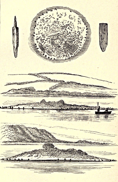
Plate XLIV.
LOUGH EYES.
Plate 2. W. F. Wakeman 1870.
Subsequently, at a season when the water was exceptionally low, the locality was again examined, and a shoal or ridge, evidently the remains of a piled causeway by which the islands in Lough Eyes had been connected together, was then discovered. In the neighbourhood a tradition existed that in ancient times “a road passed through Lough Eyes.” This lingering belief would be fully explained by the existence of a kesh or causeway—and upon this, as well as upon the main crannog, was found a quantity of bones of the Bos longifrons, red deer, ass, sheep, goat, and pig. Mixed with the animal remains was an extraordinary collection of broken earthen vessels like those in the Drumgay and Ballydoolough sites. The fragments were nearly all more or less ornamented with indented patterns, sometimes arranged simply in lines, in other cases presenting chevron designs. The illustrations (ante, pp. 93, 94) represent two of these vessels restored. Fig. 71 is a flat disc, seemingly a cover or lid. Figs. 72, 73, 98, 99, and 100, were also found in this locality. Second in position from the left side of the general view of Lough Eyes (plate XLIII.), a very small island (No. 2 crannog) may be discerned in the distance: this is a sunken crannog; its appearance is shown in the lowest sketch (plate XLIV.). To the right, in the general view (plate XLIII.), is the most northern crannog (No. 3) of the group; its general plan and details form the three upper sketches of plate XLIV. The shape was circular, the diameter about fifty feet, the piles stood almost as originally driven, but the horizontal timbers of the interior had disappeared. A cruciform section demonstrated that the island consisted of a low mound formed of sand, earth, and stones, which had settled down into their then position. A whetstone, and portion of a highly decorated quern (ante, p. 88), rewarded the search. Bones lay scattered along the beach, as well as over the surface of the islet, and pottery was found in abundance (see ante, plate XVIII.). The fourth island (No. 4) from the left of the view is represented in the sketch second from the bottom (plate XLIV.). It was similar to the last described: a cruciform section of considerable depth threw little light on the internal construction; there were only layers of earth, sand, and sticks. The result of a search and digging along the shore brought to light a portion of the upper stone of a quern, fractured bones, and small fragments of pottery. The fifth crannog was of the sunken class, although some of the stakes were still in situ. It was low and narrow, seldom above water, therefore its exploration was practically impossible. Some bones and fragments of pottery (ante, plate XIX.), a whetstone, and pieces of a jet bracelet, were the sole mementoes discovered. The sixth, and last crannog is to the extreme right of the general view (plate XLIII.). In summer-time, during low water, it was a peninsula. Many of the stakes retained their position, but a section made into it presented nothing of importance. From about the group of crannogs, fragmentary specimens of what had probably been bracelets of jet were discovered, and the axe-head of deer’s horn figured and described (ante, p. 59) was dug up in this locality. The bones, pottery, and other debris, seemed to be distributed pretty equally all around. Copper vessels had been found in connexion with these lake dwellings, but attracted no attention as they were supposed to be part of the “plant” of poteen distillers.[212] In the neighbourhood small mounds—consisting chiefly of heaps of burnt sandstone—were very common; these stones were easily pulverised.
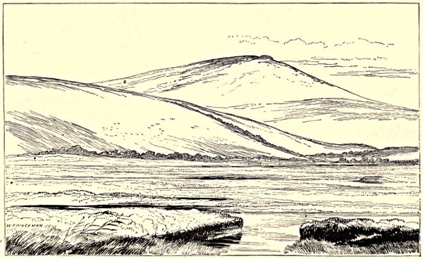
Plate XLV.
General View of the half-drained Lake of Loughavilly.
Pad, or Boat Lough, close to Lough Eyes, is a very small lake, in which is the site of a crannog, not yet explored on account of the depth of the water.
Monea.—See ante, pp. 69-70.
Wolf Loch.—There is said to have been formerly a crannog in this lake.
Loughavilly (the lake of the old tree), now nearly drained, is represented (plate XLV.) as seen from the south, with Topped Mountain in the background. The piled mound visible in the middle distance, to the right, is the remains of a crannog that appeared to belong to an age when stone implements were in use, judging from the character of the few antiquities found within it. In the summer of 1871 there was still observable a small portion of the original lake dwelling. “This consisted of a roughly squared block of oak, measuring four feet three inches in length, by one foot in breadth. It was nine inches in thickness, and exhibited upon what appeared to have been its upper surface two quadrangular mortise-holes, one of which was a square, six inches by six inches, and four inches in depth; the other, an oblong, six inches by five inches, and somewhat shallower than the former. They were placed at a distance of one foot three inches apart, and presented all the appearance of having been fashioned by a rude stone instrument.” The mortise-holes were not deeply sunk in the two logs remaining on this crannog; they are represented (plate XLVI., figs. 14 and 15). Fig. 16, a rudely-shaped stone axe-head or chisel, four and a-half inches in length by two and a-half inches in extreme breadth, was also discovered here.
Kilnamaddo.—For description of this crannog, see ante, pp. 37-39. Amongst the “finds” were an ordinary whetstone, a couple of hammer-stones, some flint-flakes, a large tray-like vessel composed of oak, some fragments of rude pottery, and a pair of rubbing-stones. Plate XLVI., figs. 5 and 9, are angle-posts of the second hut, they measure respectively three feet eleven inches, and four feet nine inches. Figs. 6, 7, and 8 (about one foot four inches in length), are pegs used probably to secure the lower logs in position; these pegs varied in size, and bore the marks of being cleanly cut by a sharp metallic instrument.
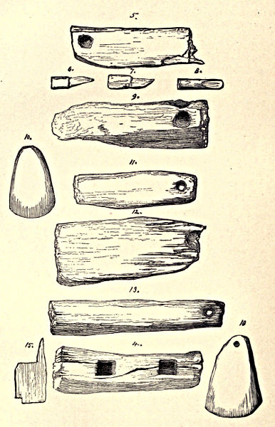
Plate XLVI.
Remains, &c., found at Loughavilly, Kilnamaddo, and the Miracles.
The Miracles.—At a place bearing this singular name, and situated near the village of Monea, turf-cutters in the year 1875 came upon the remains of a hut occupying the centre of an artificial island which stood in the middle of what had formerly been a small lake. Unfortunately the timbers and beams with which it was constructed were carried off before anyone skilled in archæological matters had seen them in situ; but the posts represented (plate XLVI., figs. 11, 12, and 13) were evidently angle-posts, resembling those in Kilnamaddo, and, like them, not exhibiting the bruised appearance produced by stone hatchets. There were pieces of iron slag, quantities of burnt wood, a well-formed crucible, sharpening and grinding stones, a stone or pounding instrument (ante, p. 74), and a beautifully-formed, highly-polished, axe-head, and a chisel of stone. Amongst the “finds” were numerous articles of bronze, which are now dispersed, and cannot be traced; but from the description given of them by the workmen they were probably fibulæ. There were also several oaken paddles, of which one is now in the Museum, R. I. A.; the dimensions of another were seven and a-quarter inches in length, the breadth of the blade being three inches; the handle terminated in an oval expansion measuring two and a-half inches across. Single-piece canoes have, from time to time, been discovered in the neighbourhood.[213]
Rossole Lake.—In the neighbourhood of this sheet of water (ante, p. 49) there lingers a tradition of a “buried city” lying in its depths; therefore, in the event of drainage, it is more than probable a crannog site might be disclosed to view.
COUNTY MONAGHAN.
During the working of the Commission for the Arterial Drainage of Ireland, six crannogs were disclosed in this county; four of these sites have not been identified.
Lough Fea.—A stockaded island in this lake (discovered in 1843) is described in Shirley’s Dominion of Farney.
Aghnamullen.—Ante, p. 135.
Lough Ooney.—Ante, p. 156.
Ballyhoe Lake, distant about five miles from Carrickmacross, was described by G. Morant as situated on the southern verge of the county Monaghan, the greater part of it being in Meath. The lake, of horse-shoe form, is of tolerable extent; the river Glyde, or Lagan, runs through it, and by this stream it is connected with several lakelets lying more northward in the county Monaghan; at the toe of the horse-shoe, owing to the large deposit of mud brought down by the river, the water is very shallow. In this lake were two artificial islands, one of great extent, the other much smaller. In the larger island, to which a causeway led from the mainland, were numerous mounds which had been partially excavated, and here were found two fine specimens of bronze pins, other articles of lesser interest in lead and iron; also a flint spear-head. The shores of the lake were for the most part boggy and full of large timber, stumps and stems appearing in great quantities, both above and below the level of the water, which was reduced several feet by the drainage of the river. The centre of the horse-shoe was occupied by a peninsula of bog-land with a coating of grass: this tract also abounded with timber, the stumps in many places projecting above the soil. In August, 1864, on the east shore of this peninsula, were observed two chert spear-heads lying just beneath the water at its lowest summer level, and a few yards further along the beach was a rude stone hatchet, about six inches long and two inches deep in its broadest part. The following spring, when the winter floods had subsided, measures were taken to search very carefully, and the result was the collection of a great many flint implements of various types, the greater number of which were lying only a few inches below the surface of the soil, and generally ashes were found with them. In one place a dark-coloured glass bead of barrel-shape was with the flint-flakes, and close to the stump of a large tree was a very fine polished stone hatchet with squared sides, the edge sharp and quite uninjured. In one of the holes made in the bog by the feet of cattle lay a beautiful little arrow-head of dark flint, triangular in shape, chipped to an exquisite sharpness, and curved inwards at the base to form the barbs. With the flakes, knives, scrapers, arrow and spear-heads of flint, were also many specimens in chert or Lydian stone. Near the exit of the river from the lake two different types of light-coloured flint arrow-heads were discovered, the one barbed, and about one and three-quarter inches, the other two inches in length, and of peculiar form; the latter lay where a deep cutting had been made during the drainage works, and near this spot was anciently a ford, the scene of several encounters between the Danes and Irish, and where in later times the forces of Elizabeth, and the Irish under Tyrone, met in battle array. In a field on the Meath side of the river, stood a castle of which no vestige now remains above the ground: the foundation may, however, still be traced, and many articles have, from time to time, been ploughed and dug up about the site of this old fortalice of the Pale. A fine silver coin of Mary, and a good specimen of a pin-brooch in bronze, with red enamel setting, were found there.
The larger crannog, separated from the mainland by a shallow channel, was in summer accessible by a narrow causeway. In one of its mounds—principally composed of ashes—were leaden bullets, sharpening-stones, and implements of iron; on its shores a flint spear-head and bronze pins; on the edges of the lake close by, flint arrow-heads, hatchets, &c., all of which, found at about the same level, were certainly submerged until the drainage works permanently reduced the height of the lake by several feet. Bullets discovered in these crannogs prove that they were occupied up to a comparatively late date.[214]
Cargaghoge.—Ante, p. 42.
Glaslough, or Erny Lough.—Ante, p. 151.
Lisanisk.—Ante, p. 151.
Lough-na-glack.—Ante, p. 81. Two bronze instruments, supposed to have been used for piscatory purposes, were found in connexion with this crannog, also several beads of amber and blue glass; a comb and three pins made of bone; an iron dagger fifteen inches in length; several primitive iron plough-coulters; fragments of iron instruments (use unknown); a long gun-barrel, or caliver; part of the lock of a pistol, and many bullets of lead.[215]
Lough Mucknoe.—Ante, p. 151.
Lough Monnachin.—Ante, p. 151.
Lough Rouskey.—Ante, p. 151.
Monalty (near Lisanisk).—The first mention of the discovery of various ancient relics in a small artificial island in this lake was made by Mr. Shirley. There was a canoe (hollowed out of a single piece of oak), measuring twenty-four feet in length, also stone and bronze celts, spear-heads, needles, pins, &c., from all which it would seem that here had been one of the strongholds of the chiefs of the district. This crannog—afterwards explored by G. Morant—is situated close to the shore, and during the low state of the water in the year 1863, it became accessible by wading over a few yards of mud. When searching on the exposed side of the island a jewelled ornament was perceived, slightly projecting above the gravel, stones, and mud of which the beach was composed. This proved to be a rock crystal, oval in shape, and set transparently; the crystal, with its silver setting, measured two and a-half inches in length, by one and three-quarter inches across, and was much corroded on the front; the little points were surrounded with a cable-twist, as was also the setting. It was pronounced by a competent authority to be a work of the fourteenth or fifteenth century. Lying on the surface of the boggy soil was another antique, considered to be a harp-pin; it was of highly-finished work in bronze, the barrel having within it indications of rust.[216] The crannog had been searched long previously by a man who made a trade of selling antiquities, so that the good fortune of discovering these curiosities must be attributed to the fact of the water-level having been so exceptionally low in the year 1863.
Rahan’s Lake is situated near Carrickmacross, and here in 1863 the hearth of a crannog was uncovered; on it were found a quantity of ashes, together with five Queen Mary shillings, fused into a mass, probably by the conflagration which had consumed the dwelling. A bronze pin, a flat spear-head, and stone celt, were also brought to light.[217]
Leesborough Lake.—An iron skean, seventeen inches long including the tang, the blade thirteen inches, one and a-quarter inches wide at the handle, and one-quarter inch thick, tapering to the point, was found here.
Kilmore Lake.—Two crannogs are known to have existed in this sheet of water.[218]
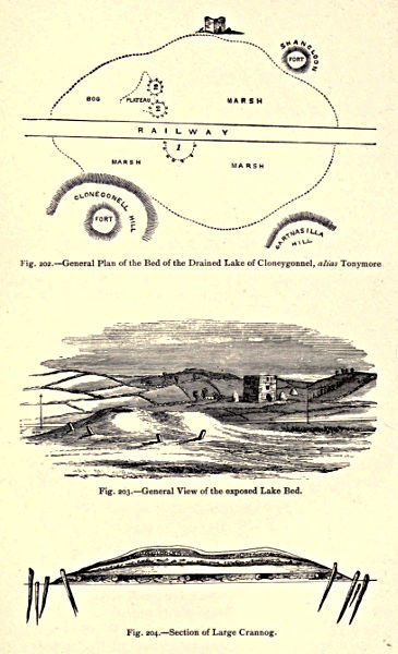
Plate XLVII.
Fig. 202.—General Plan of the Bed of the Drained Lake of Cloneygonnel, alias Tonymore.
Fig. 203.—General View of the exposed Lake Bed.
Fig. 204.—Section of Large Crannog.
COUNTY CAVAN.
Cloneygonnell (otherwise Tonymore)—a townland in the parish of Kilmore, barony of Lower Loughtee—contained three crannogs that became exposed when the waters of Tonymore Lough had been run off by arterial drainage. Although the tops of the outer row of piles could be seen projecting above the surface, yet the real nature of the largest of these islands—a green oblong mound—was not suspected until after the railway had passed through a portion of it. The land was described as rising, in a succession of low hills, from what had been the ancient margin of the lake; on the north and south sides were the raths of Shancloon and Cloneygonnell, as shown (plate XLVII., fig. 202), and there were several raths of minor importance. In 1862, Dr. Malcomson of Cavan, carefully examined the locality, and made a sketch of the general appearance of the ancient lake bed and neighbourhood (fig. 203), as well as a representation of the section of the larger crannog where cut by the railway (fig. 204). The piles or stakes were arranged in two circles, one within the other, the diameter of the greater one being one hundred and twenty feet, and that of the other ninety feet. The piles in the outer circle were very numerous, and in some instances driven in close proximity to each other; a few appeared about three feet above the surface, and upon being withdrawn and examined were found to have been carefully pointed. The stakes in the inner row were not so numerous; some of them were of oak, others being of sallow or other soft wood. Within the stockade were observed two small mounds, one at the north, the other at the south. Corresponding with the depression between these, and three feet under the soil, was discovered during the excavation a flat stone four feet square and three inches thick, resting on a number of upright blocks of oak; this, no doubt, was a hearthstone. The most elevated point of the mound, towards the south of the island, had a crater-like appearance. Besides the wooden stakes which entered into the formation of the circles, others appear to have been laid horizontally, their beam-like ends showing at that part of the enclosure which was disturbed by the passage of the railway. On exploring the crannog, and when the excavations had been carried to the centre, the cut surface presented from above, downwards—
1st. Clay.
2nd. Black and grey ashes, with small stones and sand.
3rd. Bones and ashes, with lumps of blue and yellow clay.
4th. A quantity of grey ashes, and
5th. The horizontal sleepers, or stretchers, and hazel branches resting on the peat bottom. (Plate XLVII., fig. 204.)
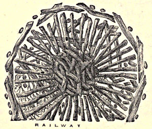
Fig. 205.—Plan of Crannog, showing the radial arrangement of the timbers.
The superficial soil was gradually removed in order to expose the original flooring and examine its peculiar arrangement. During the removal of this stratum the workmen turned up a few antique specimens, amongst them portion of a glazed crucible, and a large mass of brownish metallic dross, quite convex on one surface. The principal stretchers—about forty in number—which composed the flooring were of black oak, in a tolerable state of preservation; each plank was from six to twelve feet in length, and from six to twelve inches square. They were laid down so as to extend lengthways from the circumference towards the centre, forming a number of radiæ somewhat like the spokes of a wheel; their outer ends were kept in position by slender crooked trunks of oak-trees forming a kind of circle, these again being fixed into their places by the outer row of stockades. The planks were not in close apposition, and the spaces so left were filled with thick branches of sallow, deal, and hazel, with the bark on; many of the branches extended underneath the sleepers, thus separating them from the peat bottom. The branches were for the most part rotten, and easily broken down. Hazel nuts were found here hard and brown, as if but just fallen from the tree. When the peat was removed to a depth of two feet near the outer part of the enclosure, the space so left was immediately filled up with bog water. A similar examination made near the centre exposed a hard foundation of blue clay. The timbers composing the crannog appeared to have been roughly hewn, and were not joined together by nails or mortises; two of the stretchers, however, had mortises. This site was most thoroughly examined. In the same marsh, but nearer to the ruin of Tonymore Castle, there were traces of two other stockaded dwellings (plate XLVII., fig. 202), an elevated causeway leading from them to what had been formerly the mainland.[219]
Cornagall.—Ante, p. 67.
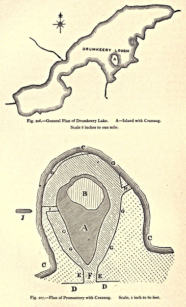
Plate XLVIII.
Fig. 206.—General Plan of Drumkeery Lake. A—Island with Crannog. Scale 6 inches to one mile.
Fig. 207.—Plan of Promontory with Crannog. Scale, 1 inch to 60 feet.
Drumkeery Lough is situated two and a-half miles north of Bailieborough. In 1863 the level of this lake having been lowered, the fact became apparent that it had been, in olden times, the abode of a lacustrine population. Plate XLVIII., fig. 206, shows the former extent and shape of the lake. Near its southern margin there was an oval-shaped island, converted into a peninsula by the change in the water-level. The aspect of the locality is described, and also represented in an outline sketch, by Professor Harkness, the original island being shown (plate XLVIII., fig. 207) by the portion marked A, including the area B, while the present peninsula is indicated by the letters CCC. The crannog was situated on the peninsula, and the approach to it had been from the south, as indicated by remains of a stockade of birch piles, DD, extending from both sides of the entrance, whilst at the eastern corner of the latter was a large oak pile with a four-sided hole cut through it. Large vertical oak slabs, with interspaces of three feet between each pile, formed the sides of the entrance EE, the interspaces filled in with smaller slabs of oak inclined outwards; the strong vertical piles had been well secured; on examination it was found that about nine feet of their length lay below the then surface. The floor of the entrance F was formed of large flat stones, and underlying this rude pavement were pieces of cleft oak. The area occupied by the crannog was an Irish acre—the longer axis being nearly north and south—and it was enclosed by piling composed principally of birch, retaining the bark. These birch poles, on the end inserted into the ground, had usually a wedge-shaped outline; some of the smaller trees seem to have been cut down by a single blow, and driven into the ground without further sharpening. Piles of oak which also occurred in the crannog were much better pointed, tapering regularly in some cases from their extremity for four feet upwards. Round oak piles were found in several parts of the stockade; whilst cleft oak was observed only at the entrance in one or two parts of the stockade, and in single piles here and there in the crannog. It has been computed that the number of piles used in forming and strengthening the construction must have exceeded 30,000. The stockade was composed of piles placed in close contiguity, without interspaces; and in the interior, near the piling, there was a layer of gravelly clay and large stones, varying from two inches to two feet in thickness, its object being to give a uniform level; and this comparatively narrow space was the only artificially elevated portion of surface in the crannog, which differed from most others previously met with in Ireland, in apparently not having required to be raised above the water; but there is evidence of the level having risen five and a-half feet since the period of its occupation. At the northern extremity of what had been the crannog was a space about a rood and a-half in size, B, occupied by fragments of burnt bones and charcoal—the kitchen midden of the place. This deposit, nine inches in thickness, rested upon the natural surface of the island, of which the entire area AB was flat, and before the lake was lowered stood two and a-half feet above the ordinary level. On the north side the supports for a landing-stage, H, were composed of two rows of piles that ran obliquely outwards from the girdle of piling G; and on the east side was another series of double piling, I, the piles about three and a-half feet apart, and they differed from the formation on the N.W. in extending inwards from the main stockade. Opposite to this, and firmly embedded in the oozy bottom of the lake, was seen a single-piece canoe, J, formed out of an oak trunk; the double row of piling extending inwards doubtless enclosed a “dock” destined to receive and secure the canoe when not in use.[220]
On the north side of the lough, nearly opposite this crannog, there were traces of another of smaller size. Birch and round piles of oak were distinctly recognizable; these occurred also at various intervals along the margin of the water, indicating the former existence of several lake dwellings. Along the shore have been discovered traces of many ancient fireplaces[221] more than six inches above the present surface of the lake, but five and a-half feet below its level previous to drainage; the largest of these consisted of a heap, thirteen feet in diameter, of small flattish, angular-shaped stones resting on peat; the small stones had a reddish colour, and consisted of fragments of greywacke shale. Immediately contiguous to this heap of small stones was another, about four feet in diameter, made up of large stones, some a foot and a-half in breadth. These larger blocks exhibited no trace of the action of fire which had given to the smaller fragments their red colour.[222]
Lough Ramor.—There are numerous islands on this lake, which is five miles in length, and from a mile to a mile and a-half in breadth. In the Irish Annals this sheet of water is said to have burst forth A.M. 2859, and in A.D. 845, King Malachy is reputed to have here attacked and destroyed an island on which rebels had fortified themselves after joining with the Danes, and from whence they continued to commit depredations on the neighbouring districts. On its shores was found the curious stone mould figured ante, p. 73; a bronze vessel like a modern pot, eleven and a-half inches high, and the same wide, with small handles attached below the rim, and one foot wanting; another bronze vessel in a perfect state, with three transverse raised lines on sides, trident-shaped ornaments spring from the base of each leg, angular handles attached between junction of rim and conical pot, fifteen and three-quarter inches high, twelve across mouth. These latter articles were both found in Lough Ramor, and in Museum, R. I. A. they appear as Nos. 40 and 43.
Lough Crannog.—Judging from the name, there was formerly an artificial island in this lake.
Lough Aconnick and Derreskit Lough.[223]
At a meeting of the Royal Historical and Archæological Association of Ireland, held at Portrush, July, 1885, a paper on the crannogs of the county Cavan was read by Mr. Seaton Milligan of Belfast, who stated that he had at various times visited several of those structures, which he considered to be more numerous in Cavan than in any other county in Ireland, owing perhaps to the great number of lakes scattered over its surface. He described some eleven sites that lay within a radius of seven or eight miles from the town of Cavan; and was of opinion that their outer row of piling was generally formed of oak, and the inner circles of smaller stakes of hazel and sallow. A looped spear-head of bronze was shown by him, and he minutely described two canoes dug out of a bog on the shores of a lake containing a crannog, and situated near Heath Lodge. A bronze rapier found near a crannog in Lough Oughter was also exhibited by him, and a description given of the castle of the same name, where Bishop Bedell was protected by the Irish during the troublous times of 1641. This castle stands on an island surrounded by piling, and bearing the impress of having been an ancient crannog whereon the more modern structure was erected (ante, p. 155).
The exact locality of two sites in the province of Ulster still remains undefined, i.e. Loch-da-damh (ante, p. 158), and the crannog attacked by Sir Henry Sidney in 1566 (ante, pp. 146-8).
PROVINCE OF LEINSTER.
COUNTY MEATH.
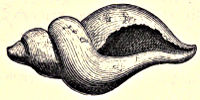
Fig. 208.—Fusus antiquus.
Lagore, otherwise Dunshaughlin. (See ante, pp. 23-5, 157, for the discovery and historical account of this celebrated crannog.)—In the kitchen midden were bones of the Bos longifrons, Bos frontosus, four-horned goat, wolf, dog, bear,[224] red deer, wild boar, sheep, fox, horse, &c.; also a sea-shell (Fusus antiquus), here figured one-third its real size. This relic is preserved in the Petrie Collection, R. I. A. It is curious to find a shell of any marine species within the bounds of a crannog situated many miles inland; and with it were shells of limpets and baccinums, together with numerous portions of fictile ware.[225] Around the crannog were several single-tree canoes, and near the centre there were two human skeletons lying at full length; the country people would not allow them to be removed; one specimen was, however, secured, and deposited in the Museum, R. I. A.[226]
Bohermeen.—Ante, pp. 82 and 171.
COUNTY WESTMEATH.
During the working of the Commission for the Arterial Drainage of Ireland a crannog was discovered in this county, but its site is unidentified.
Joristown.—In this townland, parish of Killucan, there would seem to have been formerly a crannog in the river Deel, for when deepening the bed of the stream a bronze spear-head was found five feet below the surface, and in the immediate neighbourhood of an artificial island, which is described upon the label attached to this weapon in the R. I. A. as “a little mound, formerly an island, which contained a quantity of bones and some iron spears.”[227]
Ballinderry, in the parish of Kilcumreragh, barony of Clonlonan, is situated not far from Moate. When, as the result of drainage, the water of this lake fell, it was discovered that it had formerly contained a large crannog surrounded by a stockade of oak piles, around and on which was an immense quantity of the antlers of red deer, and fractured bones of deer, oxen, sheep, and other mammalia, all afterwards sold as manure. Many objects of archæological interest found here were obtained by various collectors—some are in the Museum, R. I. A., and others have been figured in the Journal of the Royal Historical and Archæological Association of Ireland. The first notice of the crannog occurred in 1844, when Mr. Hayes forwarded to Sir W. Wilde a description of it, together with a plan and map of the locality. Two single-piece canoes were disinterred from this site, and portion of an ancient harp of wood. The pendent amulet of stone, figured p. 115, was found here.[228]
Ballinacarriga.—Ante, p. 136.
Lough Owel.—A canoe was here found, and a crannog is said to exist beneath the waters of this lake, opposite Portlenon. It is situated on a shallow, still called by the fishermen “the Old Crannog.”
COUNTY LONGFORD.
Castle Forbes.—Ante, p. 33.
Aughamore, near Granard.—At this place was said to have been discovered a curious wooden hut, constructed of black bog-oak, which lay under water in an exhausted bog at considerable depth beneath the surface. It measured twenty-three feet by ten, and had eight very strong beams supported by cross-beams firmly jointed; the side-beams mortised, as if intended for uprights. It was taken asunder in the process of raising, and as far as can be ascertained it has never been viewed by any person competent to form an opinion on the matter, so that no conjecture can be hazarded regarding the age or purpose of this so-called hut.
COUNTY LOUTH.
Iniskeen.—Ante, p. 158.
Ballyhoe Lake.—A stone pestle, an amulet made of black stone, and a flat circular stone, were here found,[229] and from the bed of the river Glyde were obtained a portion of a double comb and two beads of bone, the one seven-eighths of an inch in diameter, the other one-half inch wide.
KING’S COUNTY.
During the working of the Commission for the Arterial Drainage of Ireland, a crannog was discovered in this county, locality not mentioned.[230] “Just above the Pass Bridge, at the east end of Droughtville demesne, is a marsh, called the ‘Muddy Lake’ on the Ordnance Map, but by the people, the ‘Island Lough.’ On the north side of this marsh there is a small island, on which are the remains of Kiltubrid Castle. Between the castle and mainland, on the north side, there is an ancient causeway about one hundred yards in length.” A new channel made by the Drainage Commissioners in 1852, crossed this causeway within thirty yards of the castle. In the excavation several large pieces of oak were found, having evidently formed portion of a framework, as the mortises were tolerably perfect. Here also were discovered an article formed of wood, a pan of white bronze or findruin, three coins of the reign of Charles I., two of Elizabeth, and numerous others worn and defaced.[231]
QUEEN’S COUNTY.
Grantstown.—About the year 1860, the permanent water-level of this lake being lowered six feet, disclosed an artificial island; the stakes forming the enclosure were very sharply pointed; those laid horizontally in the centre were grooved and nailed together. R. Langrishe—who had visited Grantstown, and was often on the lake—states that the country people spoke of these remains as “the castle”: they said “it had sunk.” No canoe was found, the water in the immediate vicinity of the crannog being upwards of eighty feet in depth. The only relics discovered were an iron hasp, two nails with large heads, an arrow or spear of charred wood, a polished piece of bone resembling a pin for the hair, having grooved circles all round it at top, an enormous quantity of animal bones and charred timber, a lump of gypsum, also a rude box, about four and a-half feet in length, which contained two small bones.[232]
Lough Annagh, situated in the barony of Tinnehinch, separates the King’s from the Queen’s County; it is three miles in circumference, and the waters abound with pike, roach, and perch. In the middle of this lake, where most shallow, oak framing was visible, and a tradition existed that “in the war of 1641 a party of insurgents had a wooden house erected on this platform, whence they went out at night in a boat and plundered the surrounding country.” The site was suitable for such a retreat, the lake having formerly been embowered in forest. Queen Elizabeth thanked one of her commanders for conducting a detachment of horse in safety through the surrounding woods of the district. T. Stanley, who visited the place in 1868, observed an island-like patch rising a little above the water-level; of piles then visible he counted upwards of one hundred and twenty, arranged in lines, with spaces of two feet between the alignments, the average diameter being about five inches. The island sloped down gradually in every direction, and the piles—apparent only on one side—accommodated themselves to the slope, and were in general only a few inches above the surface of the water. Four piles had been uprooted, and thus showed that originally they were pointed with a sharp instrument, possibly with small iron hatchets similar to those found on the spot a few days previous to T. Stanley’s visit. Between the island and the shore there was a half-submerged space, about thirty feet in diameter, strewn with stones and broken querns; a few piles appeared among this debris. There was a lesser tract closely adjoining, where well-burnt brick, both whole and broken, were mingled with the stones. On the mainland, near the crannog were traces of a curious bog-pass, made like an American corduroy road, and there can be little doubt of this being “the tougher of Malahone,” mentioned by Major Edward Wood in his despatch, giving an account of an action fought by him on the 4th May, 1691,[233] when he defeated a portion of the Irish army on a hill above the lough. It is more than probable that the crannogs in question had either been the head-quarters of the Irish force, or that after their defeat the fugitives took refuge on the islands, for in the year 1868, the Rev. J. Graves saw at Tullamore articles purchased from the men who had picked them up near the crannog. The items first named seem to tell their own story.[234]
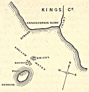
Fig. 209.—Part of Lough Annagh, enlarged from the Ordnance Survey six-inch Map, showing Sites of Crannogs.
During the progress of drainage operations, five canoes became exposed to view; they lay at the bottom in the same part of the lake, with their bow in a north-westerly direction, all having the same inclination or dip in the sandy or muddy deposit. A drawing was made, with measured plans and sections of the most perfect of the “dug-outs”; it was, however, split or fissured from starboard right through to the stern; it measured twenty-two feet seven inches over all, its greatest beam being thirty-one inches. It was formed out of one large trunk of oak, and appeared to have been hollowed by means of fire; close inspection showed that edged tools had been used in finishing it. The bottom (two inches thick) was perfectly flat, and without keel, and its perfectly smooth sides inclined outwards from the bottom. Two stout ridges of solid timber, one near either end of the “dug-out,” served to prevent the sides from collapsing, and between them and the bow and stern cavities had been hollowed out of the solid trunk, seemingly for the purpose of rendering the craft more buoyant. The port side was several inches lower than the starboard—manifestly the effect of accident. There were no traces of thwarts or benches; the sides had neither row-locks nor thole-pins; the canoe must therefore have been intended for propulsion by paddles. A horizontal hole, about one and a-half inch in diameter, had been bored in the most forward and highest part of the stern.
This entire fleet of ancient boats, together with several querns and bones found in the locality, were, in 1868, at Brittas, the residence of the Right Hon. General Dunn.[235]
Cullina.—Mr. Louis Orr states that in 1872 he saw exposed by turf-cutters in the bog of Cullina, about three miles from Maryborough, the remains of a primitive wooden dwelling. “The building lay from ten to twelve feet beneath the original surface of the bog, and consisted chiefly of four upright posts, which formed the angles of a square of six or seven feet across. These posts were about six feet in height. A quantity of timber, consisting of planks and trunks of trees, principally oak, lay scattered around, and some of the woodwork appeared to have been charred by fire. Within what had been the area of the hut was a trough made of oak, measuring three feet in length by two in breadth.” A piece of thin metal (whether bronze or iron is not stated), very much corroded, was also discovered. It was supposed to have been a sword.
PROVINCE OF MUNSTER.
COUNTY TIPPERARY.
Annagh, in the parish of Kilbarron.—There is here (as stated by the Rev. James Graves) a piled crannog, situated at the extremity of a shallow spit—submerged except when the river Shannon is very low—and at the outlet of a great circular spring or small lake, six or seven hundred yards in diameter, which runs into Lough Derg. This site has not yet been examined, but a map of the locality is here given.
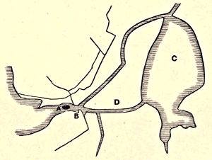
Fig. 210.—General Plan of the neighbourhood of the Crannog of Annagh. A. Piled Crannog. B. Shallow Spit, usually submerged. C. Spring, or Lough. D. Outlet into Lough Derg.
Monaincha (the island of the bog) is—as stated by W. F. Wakeman—an artificial construction, on which had been subsequently erected a church in the Hiberno-Romanesque style. It is to the present day surrounded by bog.
Lough Nahinch (the lake of the island).—In the year 1810 the waters of this lake, situated near Roscrea (at the junction of King’s County and Tipperary), having been lowered four feet by drainage, a considerable portion of the land it once covered (fig. 211, b b b b b) was laid bare, and the site of a crannog became apparent. The lake is now much reduced in dimensions, but the surrounding ground being low, its expanse in winter (a a) is greater than in summer. Mr. Trench of Cangort Park—although at the time of its discovery unaware of the real nature of the construction—gave the following graphic description of it:—“The bottom (of the lake) consists of blue shelly marl, which seems to extend to a great depth, and when dry it is exceedingly light. In the highest part of this reclaimed land, which is about the middle of the old lake, there is seen a circular part resembling in shape the top of an immense tub, about sixty feet in diameter. The large planks which form the staves are from one to ten feet (?) broad, and six inches thick, quite straight as far as it has yet been possible to trace them downwards; none of them have been raised without cutting them.” There was no appearance of either axe or saw having been used in their formation.[236]