NEW YORK TO ALBANY. (continued 4)
Reading edition
Castleton, a pleasant village on the eastern bank, with[page 177] main street lying close to the river. The cliffs, a few miles to the north, were known to the Indians as Scoti-ack, or place of the ever-burning council-fire, which gave the name of Schodack to the township, where King Aepgin, on the 8th of April, 1680, sold to Van Rensselaer "all that tract of country on the west side of the Hudson, extending from Beeren Island up to Smack's Island, and in breadth two days' journey."
No spot in all the world where poetry and romance are so closely blended with the heroic in history as along the banks of our Hudson. Wallace Bruce.
Map of Hudson River from Cocksackie to Laningsburgh.
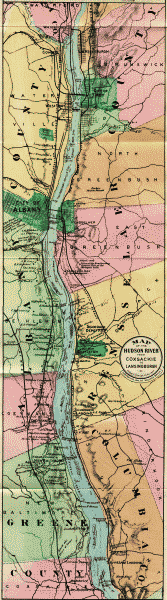
The Mahican Tribe originally occupied all the east bank of the Hudson north of Roeliffe Jansen's Kill, near Germantown, to the head waters of the Hudson; and on the west bank, from Cohoes to Catskill. The town of Schodack was central, and a signal displayed from the hills near Castleton could be seen for thirty miles in every direction. After the Mahicans left the Hudson, they went to Westenhook, or Housatonic, to the hills south of Stockbridge; and then, on invitation of the Oneidas, removed to Oneida County, in 1785, where they lived until 1821, when, with other Indians of New York, they purchased a tract of land near Fox River, Minnesota.
Domestic clans or families of the Mahicans lingered around their ancient seats for some years after the close of the Revolution, but of them, one after another, it is written, "They disappeared in the night." In the language of Tamerund at the death of Uncas, "The pale-faces are masters of the earth, and the time of the red men has not yet come again. My day has been too long. In the morning I saw the sons of Unami happy and strong; and yet before the night has come, have I lived to see the last warrior of the race of the Mahicans."
Autumn had given uniformity of coloring to the woods. It varied now between copper and gold, and shone like an infinitely rich golden embroidery on the Indian veil of mist which rested upon the heights along the Hudson. Harriet Martineau.
According to Ruttenber, the names and location of the Indian tribes were not ascertained with clearness by the early Dutch settlers, but through documents, treaties and information, subsequently obtained, it is now settled that the Mahicans held possession "under sub-tribal organizations" of the east bank of the river from an undefined point north of Albany to the sea, including Long[page 178] Island; that their dominion extended east to the Connecticut, where they joined kindred tribes; that on the west bank of the Hudson they ran down as far as Catskill, and west to Schenectady; that they were met on the west by the territory of the Mohawks, and on the south by tribes of the Lenni Lenapes or Delawares, whose territory extended thence to the sea, and west to and beyond the Delaware River. The Mahicans had a castle at Catskill and at Cohoes Falls. The western side of the Hudson, above Cohoes, belonged to the Mohawks, a branch of the Iroquois. Therefore, as early as 1630, three great nations were represented on the Hudson—
The Mahicans, the Delawares and the Iroquois. The early French missionaries refer to the "nine nations of Manhinyans, gathered between Manhattan and the environs of Quebec." These several nations have never been accurately designated, although certain general divisions appear under the titles of Mohegan, Wappinger, Sequins, etc. "The government of the Mahicans was a democracy. The office was hereditary by the lineage of the wife; that is, the selection of a successor on the death of the chief, was confined to the female branch of the family." According to Ruttenber, the precise relation between the Mahicans of the Hudson and the Mohegans under Uncas, the Pequot chief, is not known. In a foot-note to this statement, he says: "The identity of name between the Mahicans and Mohegans, induces the belief that all these tribes belonged to the same stock,—although they differed in dialect, in territory, and in their alliances." The two words, therefore, must not be confounded.
Round about the Indian village Spread the meadows and the cornfields, Stood the groves of singing pine trees, And beyond them stood the forest, Henry W. Longfellow.
It is also pleasant to remember that the Mahicans as a tribe were true and faithful to us during the war of the Revolution, and when the six nations met in council at Oswego, at the request of Guy Johnson and other officers of the British army, "to eat the flesh and drink[page 179] the blood of a Bostonian," Hendrick, the Mahican, made the pledge for his tribe at Albany, almost in the eloquent words of Ruth to Naomi, "Thy people shall be our people, and whither thou goest we will be at your side."
The Mourdener's Kill, with its sad story of a girl tied by Indians to a horse and dragged through the valley, flows into the Hudson above Castleton. Two miles above this near the steamer channel will be seen Staats Island on the east, with an old stone house, said to be next in antiquity to the old Van Rensselaer House, opposite Albany. It is also a fact that this property passed directly to the ancestors of the present family, the only property in this vicinity never owned by the lord of the manor. Opposite the old stone house, the point on the west bank is known as Parda Hook, where it is said a horse was once drowned in a horse-race on the ice, and hence the name Parda, for the old Hollanders along the Hudson seemed to have had a musical ear, and delighted in accumulating syllables. (The word pard is used in Spenser for spotted horse, and still survives in the word leopard.)
The Castleton Bar or "overslaugh," as it was known by the river pilots, impeded for years navigation in low water. Commodore Van Santvoord and other prominent citizens brought the subject before the State legislature, and work was commenced in 1863. In 1868 the United States Government very properly (as their jurisdiction extends over tide-water), assumed the completing of the dykes, which now stretch for miles along the banks and islands of the upper Hudson. Here and there along our route between Coxsackie and Albany will be seen great dredges deepening and widening the river channel. The plan provides for a system of longitudinal dykes to confine the current sufficiently to allow the ebb and flow of the tidal-current to keep the channel clear. These dykes are to be gradually brought nearer together from New Baltimore toward Troy, so as to assist the entrance of the flood-current and increase its height.
Where Hudson winds his silver way And murmurs at the tardy stay, Impatient at delay. William Crow.
[page 180]
The engineers report that the greater part of the material carried in suspension in the Hudson river above Albany is believed to come from the Mohawk river, and its tributary the Schoharie river, while the sands and gravel that form the heavy and obstinate bars near Albany and chiefly between Albany and Troy, come from the upper Hudson.
The discharge of the Hudson between Troy and Albany at its lowest stage may be taken at about 3,000 cubic feet per second. The river supply, therefore, during that stage is inadequate in the upper part of the river for navigation, independent of tidal flow.
The greatest number of bars is between Albany and Troy, where the channel is narrow, and at least six obstructing bars, composed of fine and coarse gravel and coarse and fine sand, are in existence. In many places between Albany and Troy the navigable depth is reduced to 7½ feet by the presence of these bars.
From Albany to New Baltimore the depths are variable, the prevailing depth being 10 feet and over, with pools of greater depth separated by long cross-over bars, over which the greatest depth does not exceed 9 or 10 feet. Passing many delightful homes on the west bank and the mouth of the Norman's Kill (Indian name Ta-wa-sentha, place of many dead) and the Convent of the Sacred Heart, we see Dow's Point on the east and above this the—
Van Rensselaer Place, with its port holes on either side of the door facing the river, showing that it was built in troublesome times. It is the oldest of the Patroon manor houses, built in 1640 or thereabouts. It has been said that the adaptation of the old tune now known as "Yankee Doodle" was made near the well in the grounds of the Van Rensselaer Place by Dr. Richard Shuckberg, who was connected with the British army when the Colonial troops from New England marched into camp at Albany to join the British regulars on their way to[page 181] fight the French. The tune was known in New England before the Revolution as "Lydia Fisher's Jig," a name derived from a famous lady who lived in the reign of Charles II, and which has been perpetuated in the following rhyme:
Lucy Locket lost her pocket, Lydia Fisher found it; Not a bit of money in it, Only binding 'round it.
The appearance of the troops called down the derision of the British officers, the hit of the doctor became known throughout the army, and the song was used as a method of showing contempt for the Colonials until after Lexington and Concord.
When life is old And many a scene forgot the heart will hold Its memory of this. Fitz-Greene Halleck.
Rensselaer, on the east bank of the river, was incorporated in 1896 by the union of Greenbush and East Albany. The old name of Greenbush, which still survives in East Greenbush, four miles distant, was given to it by the old Dutch settlers, and it was probably a "green-bushed" place in early days. Now pleasant residences and villas look out upon the river from the near bank and distant hillsides. Two railroad bridges and a carriage bridge cross the Hudson at this point. During the French war in 1775, Greenbush was a military rendezvous, and in 1812 the United States Government established extensive barracks, whence troops were forwarded to Canada.
Albany, 144 miles from New York. (New York Central & Hudson River Railroad, Boston & Albany, West Shore, Delaware and Hudson, the Hudson River Day Line and People's Line.) Its site was called by the Indians Shaunaugh-ta-da (Schenectady), or the Pine Plains. It was next known by the early Dutch settlers as "Beverwyck," "William Stadt," and "New Orange." The seat of the State Government was transferred from New York to Albany in 1798. In 1714, when 100 years old, it had[page 182] a population of about 3,000, one-sixth of whom were slaves. In 1786 it increased to about 10,000. In 1676, the city comprised within the limits of Pearl, Beaver and Steuben streets, was surrounded by wooden walls with six gates. They were 13 feet high, made of timber a foot square. It is said that a portion of these walls were remaining in 1812. The first railroad in the State and the second in the United States was opened from Albany to Schenectady in 1831. The pictures of these old coaches are very amusing, and the rate of speed was only a slight improvement on a well-organized stage line. From an old book in the State Library we condense the following description, presenting quite a contrast to the city of to-day: "Albany lay stretched along the banks of the Hudson, on one very wide and long street, parallel to the Hudson. The space between the street and the river bank was occupied by gardens. A small but steep hill rose above the centre of the town, on which stood a fort. The wide street leading to the fort (now State street) had a Market-Place, Guard-House, Town Hall, and an English and Dutch Church, in the centre."
I wandered afar from the land of my birth, I saw the old rivers renowned upon earth, But fancy still painted that wide-flowing stream With the many-hued pencil of infancy's dream. Oliver Wendell Holmes.
Tourists and others will be amply repaid in visiting the new Capitol building, at the head of State Street. It is open from nine in the morning until six in the evening. It is said to be larger than the Capitol at Washington, and cost more than any other structure on the American continent. The staircases, the wide corridors, the Senate chamber, the Assembly chamber, and the Court of Appeals room, attest the wealth and greatness of the Empire State. The visitor up State Street will note the beautiful and commanding spire of "St. Paul." The Cathedral is also a grand structure. The population of Albany is now 100,000, and its growth is due to three causes: First, the Capitol was removed from New York to Albany in 1798. Then followed two great enterprises, ridiculed at the time by every one as the Fulton Folly and Clinton's Ditch—in other words, steam navigation, 1807, and the[page 183] Erie Canal, 1825. Its name was given in honor of the Duke of Albany, although it is still claimed by some of the oldest inhabitants that, in the golden age of those far-off times, when the good old burghers used to ask the welfare of their neighbors, the answer was "All bonnie," and hence the name of the hill-crowned city.
Canals, long winding, ope a watery flight, And distant streams and seas and lakes unite; From fair Albania toward the fading sun, Back through the midland lengthening channels run. Joel Barlow.
To condense from H. P. Phelps's careful handbook of "Albany and the Capitol:" in 1614 a stockaded trading-house was erected on an island below the city, well defended for trading with the Indians. In 1617 another was built on the hill, near Norman's Kill. The West Indian Company erected a fort in 1623 near the present landing of the Day Line. In 1664 the province fell into the hands of the English and the name was changed to Albany. In 1686 it was incorporated into a city. It was the meeting place of the Constitutional Congress 1754, the proposed Constitution of which, however, was never ratified. Washington visited it in 1783. The Erie Canal was opened in 1825, a railroad to Schenectady in 1832, the Hudson River in 1851, a consolidated road to Buffalo in 1853, and the Susquehanna Railroad to Binghamton in 1869. State Street at one time was said to be the widest city thoroughfare in the country, after Pennsylvania Avenue in Washington. The English and Dutch Churches and other public buildings, once in the midst of it, but long since removed, account for its extra width. The State Capitol has a commanding site. The old Capitol building was completed in 1808. The corner-stone of the present building was laid June 24, 1871, and it has been occupied since January 7, 1879. According to Phelps, "the size of the structure impresses the beholder at once. It is 300 feet north and south by 400 feet east and west, and with the porticoes will cover three acres and seven square feet. The walls are 108 feet high from the water-table, and all this worked out of solid granite brought, most of it, from Hallowell, Me.
The impression produced varies with various persons.[page 184] One accomplished writer finds it "not unlike that made by the photographs of those gigantic structures in the northern and eastern parts of India, which are seen in full series on the walls of the South Kensington, and by their barbaric profusion of ornamentation and true magnificence of design give the stay-at-home Briton some faint inkling of the empire which has invested his queen with another and more high-sounding title. Yet when close at hand the building does not bear out this connection with Indian architecture of the grand style; it might be mere chance that at a distance there is a similarity; or it may be that the smallness of size in the decorations as compared to the structure itself explains fully why there is a tendency to confuse the eye by the number of projections, arches, pillars, shallow recesses, and what-not, which variegate the different facades. The confusion is not entirely displeasing; it gives a sense of unstinted riches, and represents the spirit that has reared the pile."
Nor let the dear love of its children grow cold Till the channel is dry where its waters have rolled. Oliver Wendell Holmes.
The Governor's room, the golden corridor, the Senate staircase, the Senate chamber, the Assembly chamber, and the Court of Appeals room are interesting alike for their architectural stone work, decorations and general finish. The State Library, dating from 1818, contains about 150,000 volumes. The Clinton papers, including Andre's documents captured at Tarrytown, are the most interesting of many valuable manuscripts. Here also are a sword and pistol once belonging to General Washington. The Museum of Military Records and Relics contains over 800 battle flags of State regiments, with several ensigns captured from the enemy. Near the Capitol are the State Hall and City Hall, and on the right, descending State Street, the Geological Hall, well worthy an extended visit. The present St. Peter's Episcopal Church, third upon the site, is of Schenectady blue stone with brown trimmings. Its tower contains "a chime of eleven bells and another bell marked 1751, which is used only to ring in the new year." Washington Park, consisting[page 185] of eighty acres and procured at a cost of one million dollars, reached by a pleasant drive or by electric railway, is a delightful resort. It is noted for its grand trees, artistic walks and floral culture. Several fine statues are also worthy of mention, notably that of Robert Burns (Charles Calverley, sculptor), erected by money left for this purpose by Mrs. McPherson, under the careful and tasteful supervision of one of Albany's best-known citizens, Mr. Peter Kinnear. A view from Washington Park takes in the Catskills and the Helderberg Mountains.
No wonder that his countrymen today, led by the Congress of this great Republic, celebrate the transaction and the scene where Washington refused to accept a crown. William M. Evarts.
And now, while waiting to "throw out the plank," which puts a period to our Hudson River division, we feel like congratulating ourselves that the various goblins which once infested the river have become civilized, that the winds and tides have been conquered, and that the nine-day voyage of Hendrick Hudson and the "Half Moon" has been reduced to the nine-hour system of the Hudson River Day Line.
Those who have traveled over Europe will certainly appreciate the quiet luxury of an American steamer; and this first introduction to American scenery will always charm the tourist from other lands. No single day's journey in any land or on any stream can present such variety, interest, and beauty, as the trip of one hundred and forty-four miles from New York to Albany. The Hudson is indeed a goodly volume, with its broad covers of green lying open on either side; and it might in truth be called a condensed history, for there is no other place in our country where poetry and romance are so strangely blended with the heroic and the historic,—no river where the waves of different civilizations have left so many waifs upon the banks. It is classic ground, from the "wilderness to the sea," and will always be the poets' corner of our country: the home of Irving, Willis, and Morris,—of Fulton, Morse, and Field,—of Cole, Audubon, and Church,—and of scores besides, whose names are household words.
The Hudson's cable-tow of yore Bound gallant sire and sturdy son With hearty grasp from shore to shore Robert Burns and Washington. Wallace Bruce.
[page 186]