REMARKS ON The LETTER of Admiral DE FONTE. (continued 3)
Reading edition
As to the Cod and Ling in Lake de Fonte, or as to Salmon, it is not known that there are either Cod, Ling or Salmon in Hudson's Bay: Neither have there been found Shoals or Banks to which the Cod could repair; nor is it known that any Cod have been catched beyond Latitude 57; an Article to which Davis was particularly attentive: Therefore it is not probable that they should come from the North Sea through Hudson's Bay to Lake de Fonte. De Fonte mentions Shoals in the North-east Part of the South Sea, which he passed up. And in Vizcaino's Voyage there is an Account that, off the Island Geronymo on the Coast of California, the Ships Companies supplied themselves with Cod and Ling; which shews there are Cod and Ling in those Seas. It was reasonable for de Fonte to suppose that the Cod and Ling came from the Eastward from the Baccaloos, neither could he otherwise suppose, as the contrary is only known from Observations made much later than that Time.
Fox had advanced in 1635, when he published the Account of his Voyage, that there was a free and open Communication of the Western Ocean with Hudson's Bay: Which was looked on as an incontestable Fact until the Voyage of Captain Middleton. What Fox said was consistent with the Opinion which all the Discoverers had of the Proximity of the Western Ocean; who therefore judged of the Probability of their Success in the Parts they went into, from the Course of the Tides, which if there was no Western Tide there was no Passage. This probably prevented that Success, as to a Discovery of a Passage, which through their Assiduity might otherwise have been obtained, had they not paid such a Regard to the Tides, but made a due Survey of the Inlets and Openings of the Coast, which on their not finding that a Western Tide came from thence they deserted, which was also the Case as to Captain Moor in the Search of Pistol Bay as called, to Southward of Lord Southwell's Isles, there was no Western Tide; therefore a compleat Discovery of that Part was not made.
It is to be considered that the Northern and Eastern Parts of America, are more intermixed with Waters than the Parts to Southward are, being a high mountainous Country. The Mountains chiefly consisting of a brown rocky Substance, not penetrable by the melting Snows or Spring Rains, which therefore run off into the Levels and Valleys, and form inland Seas, great Lakes, and Inlets, which vent their Waters into the Ocean, necessary for carrying off that great Quantity and vast Bodies of Ice which are formed in the Winter in those Parts, not to be dissolved, as the greater Part is which is formed to the Southward, by the Influence of the Sun. The Northern and Westward Part of America is also mountainous, and high Ridges of Mountains were seen from the Head of Wager Bay on the opposite Shore of what appeared to be a Lake; therefore there must be Lakes and Seas to Westward, Reservoirs for the melting Snows and Rains, also some Outlet or Channel to carry off the great Quantities of Ice also formed in those Parts; and with which Barnarda's Account is consistent, and the greatest Reservoir and Discharge seems to be to the Northward by that North-east Part of the Tartarian Sea. The Lake Velasco, Lake Belle, Lake de Fonte, may be all supposed to proceed from the same Cause, the melting Snows and Rains, receive the Ice from the Waters which run into them, which, from the Strength of the Currents and Tides, is soon shot from the Shores of such Lakes, broken to Pieces and carried off into some Passage or Inlet into the South Sea; and such a Vent or Channel to carry off such Bodies of Ice must necessarily be, agreeable to what is known by Observation in other Parts. The Objection of the great Distance it is between the Ocean and the Sea at the Back of Hudson's Bay, and where Shapley was met, will appear of no Validity when we consider the Distance between the Streights of Gibraltar and the Northern Part of the Black Sea. Between the Entrance of the Sound to the Entrance of the White Sea, between which there is Communication of Waters, or very nearly so. And from Point Comfort in Hudson's Bay to Alderman Smith's Sound in Baffin's Bay, between which there is a Communication of Waters without entering into the Ocean or Davis Streights. From Lake Superior to the Streights of Belle Isle at the Back of Newfoundland, or to Cape Breton, is near forty Degrees of Longitude, or equal to 390 Leagues. And Lake Superior hath a Communication with Hudson's Bay.
This great Afflux of Waters form such Meanders and Labyrinths, as it is impossible to say whether there is a Communication of Waters, or whether the Waters are divided by smaller or larger Tracts or Slips of Land, without an absolute Survey. The Lands so double or fold one within the other, that unless you get a proper Sight of such Lands so as to distinguish this, to discover the Opening that is between them, there is an Appearance of a Continuance of the Land, and consequently of a Termination of the Waters. So long as the Tide Argument prevailed it was not thought necessary to be so accurate in the Searches. A Sight of the Land trending a Course contrary to that Course which the Discoverers were to pursue to make a Passage, and the Tide coming from the Eastward, rendered a Search any further in those Parts unnecessary: and it may be owing to the great Impropriety of adopting a particular System, more than to any other Cause, that the Discovery of a North-west Passage was not made by those brave industrious Discoverers, who in a Series succeeded each other from Frobisher to James and Fox.
This seems to be certain, that there must be one great Channel, as Hudson's Streights are to Eastward, also to Westward though intricate by which the Waters to Westward pass into the South Sea, and as that to Northward, the North-east Part of the Tartarian Sea. We already know there is not a Communication by Hudson's Bay, thro' any Inlet by which the Waters do come in there or sufficient for that Purpose; neither round the Head of Repulse Bay, for then the Current would have been met coming from Westward. Therefore such Channel must be to Southward and Westward, consistent with de Fuca's Account of a Streight, in some such Manner as is represented in the Map annexed. Which Account also agreeable to that of Peche.
De Fuca says, he sailed twenty-six Days up such Streight before he entered the Sea; that the Streight grew wider before he entered the Sea. If we allow him fifteen Leagues a Day, from the Entrance of such Streights out of the South Sea to where he entered the Sea, by him supposed the North Sea, the Distance is 390 Leagues. As he mentions that he found it wide enough every where, this Expression shews that he did not suppose himself in the Ocean, but in a Gulph of the Ocean. And Martin Chacke expresses himself, that after he overshot the Gulph, he set no more Sight on any other Land. Therefore the Distance is agreeable to that Distance which de Fuca must have gone to come into that Sea where de Fonte met Shapley; the Description that he saw both Shores, makes a Consistency also in those Accounts. Before de Fonte's Expedition, Hudson's Bay had been discovered, yet that Discovery made no Alteration as to the Accounts of de Fuca and Chacke, as Fox said beyond Lat. 64, round that Land there was incontestably a Communication with the Western Ocean. Here is an Agreement in three Accounts, by separate Persons at a Distance of Time, who had no Intelligence of what had been done by each other; for Chacke was a Portugueze; and as de Fuca had made his Report to the Viceroy of New Spain of what he had done, and what he had done seems to be mostly accounted of by himself, therefore no Regard might be had to it in drawing de Fonte's Instructions: All which three Accounts agree in there being a Sea to Westward of Hudson's Bay.
De Fuca mentions he was ashore; saw Marks of Gold and Silver; Marquisates the same which was made such an Account of after Frobisher's return from his first Voyage, and from which it may be inferred it was a barren mountainous Country which de Fuca passed through. He was afraid of the Natives, who were clad in Beast Skins; and from whose Behaviour he must have had some Apprehension that they would cut him off, as he mentions that he was not armed against them. De Fonte is very express as to the civil Behaviour of those Indians he met with, so contrary to the Character of those whom de Fuca saw. Therefore those whom de Fuca saw were the Eskemaux, who frequent the mountainous and desolate Parts, and near to the Salt Waters where they can catch Fish, also the Seal and the Whale, from which they get many Conveniencies besides what is necessary for their Subsistance; who are mentioned to be also on other Parts of the Coast of California; are represented as a fierce and barbarous People, who hold no Treaty or Amity with their Neighbours, who are always in Fear of them.
That de Fonte should not pass up the North-east Part of the South Sea, but go through Land, must have been, that the North-east Part of the South Sea was represented as a Gulph, not a Streight, from some Observations made prior to that Expedition, as to which the Observers might be deceived, by its taking a Southerly Course through some Inlet or Opening obscured by Islands, or the Entrance narrow, that they concluded it only to be some small Branch which soon terminated; having, at the same Time, a large open Channel before them, which they finding afterwards surrounded with Land, concluded there was no Communication with any other Waters, but that they had seen the Extremity of these Waters to Eastward. That these Waters took a Course through that desert mountainous Country, until they joined with the Waters of the Streights that de Fuca came up, the People of Conosset might not be able to give a just Account of, as they lived so far to Northward and Eastward. Though they, as the Natives of Conibasset also came occasionally into the North-east Part of the South Sea; the one mostly frequented to Northward and Eastward, the other to Northward and Westward, as is apparent from de Fonte's Account; where they had level and fruitful Tracts, as they produced so much Maiz; a hunting Country, as there were three Sorts of Deer; also Fish in their Waters. Whereas the Country on the opposite Shore of the North-east Part of the South Sea, as is apparent from being the Resort of the Eskemaux, would be rugged, rocky, and remarkably barren, with little Intermixtures of level and fruitful Spots. Therefore the People of Conosset, or Conibasset, would have no Inducements to go into those Parts. May be supposed the opposite Coast was the Limits of their Enemy's Country, with whom if they went to War, and knew that the Waters of the North-east Part of the South Sea did communicate to Southward with other Waters; yet it cannot be imagined that they went up those Waters so far in their Enemy's Country of so wild a Disposition, where they were always in Danger of being surprized, as to know whether those Waters joined with the Sea in which Shapley was met. Might also be jealous if the Jesuits, or Parmentiers, or others who came there, were very particular in their Enquiries, that they intended to go and reside amongst their Enemies, which, as the Nature of Indians is, would cause them to be on the Reserve, and slack in their Informations, as to those Parts.
That those Persons who were in those Parts before this Expedition of de Fonte, got no Information of this Streight, or of the Waters, as to the Course of them to Southward, there must be a considerable main Land to Southward of Lake Belle and Lake de Fonte, as is expressed in the Map, and as to the Sea to Eastward, that Part of it which was to Southward of Ronquillo, no more would be apprehended of it, being unacquainted as to the Streight, than that it was a Part of that Sea contiguous to Hudson's Bay; and it not being known at that Time but the Tides came from the Eastward, would have no Reason to infer, from the Sea running to Southward, that it communicated with a Streight there.
To take away the Improbability of what is here advanced, we should reflect what Assurances former Discoverers gave, that had but the Season permitted to proceed, they should certainly have made a Passage; though when an Attempt was again made they found their Mistake; and from Observations then made, they saw good Reason to have a different Opinion as to the Nature of the Passage from what they had before, and very reasonable, as their Searches were made in Parts entirely unknown; and as to the Appearance of the Land, the Course of the Waters, and the Set of the Tides, the most judicious might be deceived.
The Spanish Nation had not been able to make out a Passage by their various Attempts, agreeable to the Accounts of private Persons, which probably might give an Opportunity for the Representations of the Jesuits to be attended to, who would urge every Argument in Behalf of their Discovery, and endeavour to invalidate the former Accounts as to a Passage; which by that Time, from the ill Success as to discovering a Passage, might not be at that Time so much thought of; and as Difference in Time produces a Change in Opinions, whatever makes for the reigning Opinion is adopted, as every Thing that is contradictory is depreciated. The Arguments for the Opinion which prevailed before for a navigable Passage might be treated as fallacious and insignificant, and the Instructions for the Expedition of de Fonte might be drawn agreeable to the Jesuits Plan, whom it is evident knew nothing of a Streight, but considered the Land of America as one continued Continent to Latitude 66. And whatever Weight this Conjecture may have, it is apparent from the Consideration of de Fonte's Letter, that the Instructions were drawn from the Information of some who had been before in those Parts: And by whom can it be supposed more properly that the Court received the Information which they had than from the Jesuits, whose Understanding and Character would admit them to a free Converse with the Minister on a less Occasion than they would now have, to give an Account of those Parts they had been in.
The Court of Spain does not seem, from the Proceedings, to be of the same Opinion with the Jesuits, or de Fonte after his return. As the Governor of Cinoloa is immediately ordered to take a Survey of the Coasts and Harbours of California. And the next Year Admiral Cassanate is sent from Old Spain; and it is probable the Court was not of the Opinion of the Jesuits when they gave this Information, but formed the Instructions for de Fonte agreeable thereto. As the most expedient Method, at that Time, for intercepting the People from Boston, was to go the Way they gave an Account of with the Boats through Land, as the Ships might meet with Difficulties and Delays in passing up the Streights, also ran great Hazard; the Boston Ship might pass them unperceived. Whereas, on the Plan which was pursued, if they heard by the Natives that the Boston Ship had passed, and taken her Course further to Southward or Westward, de Fonte would have repaired aboard his Ship, proceeded down Los Reyes, and with the Diligence which he would have made Use of, fell in with the Boston Ship either in such North-east Part of the South Sea, or on the Coast of California, leaving Orders for Barnardo how to act in this Respect on his return. From which Conduct, and the Look-out that was kept on the Coast of Mexico and Peru, it would have been also impossible for the Boston People, unacquainted with these Parts, and not expecting such a Diligence was used to intercept them, to have made a successful Voyage.
That there is a Sea to the Westward of Hudson's Bay is reported by the Indians, and is represented to have Ice in it like Hudson's Bay.
Governor Dobbs, in his Account of the Countries adjoining to Hudson's Bay (P. 19.) mentions from Joseph le France, that their Savages reported that in the Bottom of the Northern Bay there is a Streight, they can easily discover Land on the other Side: They had never gone to the End of that Streight. They say there is Ice there all the Year, which is drove by the Wind, sometimes one Way sometimes another.
The Indians, who are called Northern Indians, having their Habitations to North-west of Churchill, mention a Sea to the Westward of them, and which is from Churchill Factory in Hudson's Bay twenty-five Days Journey, not a direct Course, but from the round they are obliged to take. They speak of the Eskemaux Indians to Eastward of them, but never give an Account of any other Nations to Northward or Westward of them. Mr. Scroggs, who was sent out by the Hudson's Bay Company in 1722, had two Northern Indians, whom he carried with him, when he was in about Lat. 62. knew the Country very well, and had a great Desire to go home, saying they were but two or three Days Journey from their Family. And the Northern Indians who were with Captain Middleton, were desirous of his going near the Shore, between Lat. 62 Deg. and 64. In Lat. 63° and 14´, Captain Middleton put two of the Indians ashore, who were desirous of returning to their own Country. And the Author saw an Indian, whose Daughter had married a Northern Indian and been home with her, direct his own Son to sketch out on a Board with a burnt Stick, the Coast of that Sea, which his Son did, and the Father afterwards took and corrected it where he said the Son had mistook.
Governor Dobbs, in the Account mentioned P. 45, mentions, 'that Joseph le France was acquainted with an Indian, who lived at some Distance from Nelson River in Hudson's Bay, who, about 15 Years before that Time, went to War against a Nation living Northward on the Western Ocean of America. When they went they carried their Families with them, and hunted and fished from Place to Place for two Winters and one Summer, having left their Country in Autumn, and in April following came to the Sea Side, on the Western Coast, where they immediately made their Canoes. At some little Distance they saw an Island, which was about a League and a Half long when the Tide was out, or Water fell, they had no Water betwixt them and the Island, but when it rose it covered all the Passage betwixt them and the Island, as high up as the Woods upon the Shore. There they left their Wives and Children, and old Men, to conduct them home and provide them with Provisions, by hunting and shooting for them on the Road; and he, with thirty Warriors, went in Quest of their Enemies the Tete Plat. After they parted with their Families they came to a Streight, which they passed in their Canoes. The Sea Coast lay almost East and West; for he said the Sun rose upon his Right Hand, and at Noon it was almost behind him as he passed the Streight, and always set in the Sea. After passing the Streight they coasted along the Shore three Months, going into the Country or Woods as they went along to hunt for Provisions. He said they saw a great many large black Fish spouting up Water in the Sea. After they had coasted for near three Months, they saw the Footsteps of some Men on the Sand; then judged they were near their Enemies, quitted their Canoes, went five Days through the Woods to the Banks of a River, found their Enemy's Town, made an Attack, the Enemy rallied and put them to flight.' Then proceeds, 'upon which they fled to the Woods, and from thence made their Escape to their Canoes before their Enemies overtook them, and after a great deal of Fatigue got to the Streight; and, after getting over, they all died one after the other, except this old Man, of Fatigue and Famine, leaving him alone to travel to his own Country, which took him up about a Year's Time.' When he reached the River Sakie he met his Friends again, who relieved him.
The Indians that this antient Indian went to War against, (and this Indian was living at York Fort in Hudson's Bay in 1746) are mentioned to be the Tete Plat, or Plascotez de Chicus. The Part which they inhabit is variously laid down by the Geographers; by some in Lat. 67, Long. 265 East from Ferro, which is the extremest Longitude that their Country is laid down in. Mons. de Lisle and others place them in Lat. 63, and Long. 280 East from Ferro, so their true Situation is uncertain. Yet it is apparent that they do not live near to or on the Coast of the South Sea, or Western Ocean. For what Joseph le France in this Account, and so of all Indians, meant by the Word Sea is any Mass or Collection of Salt Waters which have a Tide. P. 38, in the same Work, giving an Account of the Indians passing down to York Fort. 'The River de Terre Rouge, and from that Place they descend gradually to the Sea.' By which Joseph le France means Hudson's Bay. Governor Dobbs mentioning the Western Ocean of America is a Mistake, which he was led into as having a Consistency with the System which he had adopted. These Warriors left their own Country in Autumn, are said to have lived near Port Nelson or York Fort, and were at the Sea Side in April. Their not being sooner is not to be attributed to the Length of the Journey but to the Season of the Year. The old Indian was a Year returning to his own Country; but he was fatigued and almost famished, so labouring under a great Debility, and had his Food to seek in whatever Manner he could procure it. The Winter also came on soon after his return from the Enemy. They were on the Western Side of the Land, which separates Hudson's Bay from that Sea, where they saw so great a Tide. Afterwards passed a Streight, which Streight lay North and South. The Sea they came from and the Sea they passed into after such Streight, laid East and West. They continually kept the Western Shore, as that was the Side on which their Enemy lived; and though they were so long as three Months in their Passage, they were obliged to go every Day ashore to hunt, being thirty in Company, required a pretty considerable Subsistance. Their Canoes can bear no Serge or Wave when the Wind blows, therefore are obliged to keep close to the Shore, and must go to the Bottom of each Bay.
This Account agrees both with that of de Fonte and de Fuca. The Sea they imbarked on was that at the Back of Hudson's Bay, and the Streight might be formed by some Island, or both the Shores approach each other, tho' the Account is not sufficiently intelligible to make any Description of it in the Map. De Fuca says the Streight grew wider when he entered such Sea, which seems to imply it had been narrow. And the Indians, as before-mentioned, said there was a Streight, and they can perceive the Land on the other Side. De Fuca also mentions he went ashore, and found the Land fruitful, and rich of Gold and Silver and Pearls, and other Things, like Nova Hispania. Which shews it was a mixed Country; for a fruitful Country and a Produce of Gold and Silver is not a Description compatible with one and the same Part. The one we may suppose the Description of the Parts nearer the Ocean, the other of the Parts where the Tete Plat live: But the old Indian seems also to make a Distinction; for he says they went to hunt in the Country and the Woods. When they had passed the Streight, they came into the broader Part of the Streight of Anian, which appeared to them to be a Sea. As to the Place of their Imbarkation, they would be directed by where they could procure Birch to make their Canoes.
The true Situation of the Part they went to, nor where they imbarked is not to be determined with any Certainty; but it doth not carry the least Probability that they went to War with a People more than a thousand Miles distant. It is scarce probable they had ever heard the Name of the Inhabitants of those Parts, much more so acquainted with their Situation as to be able to form a Plan of going to conquer them. There must have been some particular Cause for their going to War with a People so far off; what that was it would be difficult to imagine; if it was only to shew their Prowess, they must have had Enemies nearer home, against whom there was a greater Probability of succeeding. Neither could it be at that Distance, as they had one continued Scene of Fatigue until they reached the Streights; their Hearts broken by Reason of the Disappointment, the Heat of Summer, no venturing ashore but for a very short Time, either for Food or Refreshment, as they expected the Conquerors to follow them with Canoes, it would have been impossible for them to have reached the Streight. If they had a hundred Leagues a direct Course until they attained the Place of their Imbarkation, and by going round the Bays, might be near twice that Distance, the Current also against them, it would be sufficient, stout young Fellows, and full of Blood as they were, for what they underwent to be fatal to them. It is evident the Streight was not far from where they imbarked, and the Relation seems to express it so, as they had such a Fatigue in attaining to it. Allowing the Tete Plat to be in Long. 108 Degrees from London, and the true Course was W. S. W. or E. N. E. on their return, with a Distance of a hundred Leagues, they would alter their Latitude 114 Miles, and make 277 Miles Departure, which, with 27 Miles to a Degree, would make the Place of their Imbarkation to be in Longitude 98 from London, about the Longitude of Ronquillo. As to the Latitude where the Tete Plat Indians live, and as to the Longitude it is but conjecture; there is such a Discordancy and Contradiction in the Maps, there is such Uncertainty, that the North-west and West Parts beyond Hudson's Bay in the Latitude of Churchill, seem to be entirely unknown. But this is to be observed, and which has been my Direction in these Observations, the Northern Indians and the Home Indians about the Factory of York Fort, mention these Tete Plat Indians, and speak of them as their Enemies, therefore they cannot be at so great a Distance as the Western Ocean, neither further than where I have supposed their Country to be. For as the Time the Indians were going there three Months, that is not to be considered so much with respect to the Distance, as they would choose a proper Season, when there were the fewest Indians in the Towns, and were mostly engaged abroad in their Summer hunting. Perhaps there are no People who plan better in the Partizan Way, and execute with more Success. They fix the Time they intend to make their Attack before they set out, then proceed easily and gradually towards their Enemy's Country, allowing a Sufficiency of Time in which they may recover any Accident by which they might be delayed, as unseasonable Weather, Difficulty and Disappointments as to procuring Subsistance, or any Indisposition, that they go to Action in their full Strength and Vigour; as an Indian who conducts an Expedition would be as much contemned for Want of Prudence, on his Return to the Towns, as he would for his Want of Conduct in leading his People to an Attack, and when the Enemy was too powerful not bringing them off without the Loss of a Scalp. In either of which Cases the young People, who observe freely the most exact Discipline, and implicitly obey what he orders, would not go any more to War with him.
Which Way the Boston Ship made this Passage is uncertain. Gibbons was acquainted with Bylot, was Shipmate with him in Sir Thomas Button's Voyage. Bylot was also with Gibbons the Time he lost his Season, by being detained in the Ice. Bylot made an Expedition for Discovery of a Passage in the Year 1615, on Sir Thomas Button having at a Trial of a Tide off the Island of Nottingham, in Hudson's Streights, found it came from the North-west, and to be from an Opening at the Back of Cary's Swans-nest, this Tide he went in Pursuit of; and was as far up as Lat. 65 Deg. 26 Min. then supposed where he was was nothing but a Bay, but could not (he had gone up the East) return down the West Shore. Whether Gibbons took his Information from Bylot, and pursued his Plan, is uncertain, and found his Way round the Head of Repulse Bay. He was also acquainted with what Fox had done, who went into Lat. 66 Deg. 5 Min. so further than Bylot, who did not return down the Western Shore; but his People being indisposed, and not finding a North-west Tide, he hastened home. These Parts, therefore, were not properly searched, the Conclusion drawn for there not being a Passage there, being that the Tide came from the Eastward.
Or whether Gibbons went through Hudson's Bay is equally uncertain. The undiscovered Parts of which Bay, or the Openings that were not determined in the Expedition in the Year 1747, are in a Map hereto annexed. But the Termination of Chesterfield's or Bowden's Inlet hath been since searched by the Direction of the Hudson's Bay Company, and a Plan made of it, which I have not seen. Their Design was to go as far up such Inlet until it terminated, or there was a Passage into another Water. But as it is terminated by Land, and if there is no Inlet or Opening left on the North or South Shore unsearched, or a Survey taken from the Heights, by which they could be satisfied there was no Communication with any other Waters by which there could be a Passage, it is to be concluded that Chesterfield Inlet is no Streight or Passage as was expected, and it appeared to be as far as the Californias Boat went up, according to the Report made at that Time. The People who had been in the Boat belonging to the California, when the Ship was going up Wager Bay, where, from the Depth of the Water, the Breadth between both Shores, the high mountainous Land, there was great Reason to believe there was a Streight or Passage: Those People declared, if there was a Streight they were assured that Chesterfield Inlet was a Streight also.
There remains then to be searched for the Discovery of a Passage, the Opening called Pistol Bay, in Hudson's Bay. That Part which Bylot and Fox left undetermined, along the Coast to Southward of Baffins Bay called Cumberland Isles, which entirely consists of large Inlets and broken Lands. We may be too premature in our Conclusions as to the Impracticability of such a Passage from the high Latitude and the Shortness of the Season, as we have the Instance of the Boston Ship, which was so far advanced in the Sea to Westward of Hudson's Bay in the Month of August; and some Time would be taken up in finding out the Way. The strong Tides that set in, and the Current when to Westward, which there is apparently in the other Sea, may give an Expedition that may compensate against the Shortness of the Season. It is but a short Time that would be required to pass that Part of the Passage which lies in those high Latitudes, as the Course would be soon altered to the Southward.
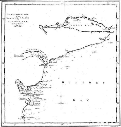
The Discoveries made in the North West Parts OF HUDSONS BAY. By Capt. Smith in 1746 & 1747.
Seyxas y Lovera, in his Theatro Naval Hydrographico, in the seventh Chapter, P. 426, says, 'North-east of America there is the Coast of Greenland, from sixty to sixty-eight Degrees, where there is to the East the Entrance of the Streight of Frobisher. North-west in the different Islands which compose the Northern Parts of America, there is the Entrance of the Streight of Hudson, where the North Sea communicates with the South Sea, passing out of the Entrance of the Streight of Anian, which runs North-east and South-west to the Northward of the Island of California, which Streight is hid by great Gulphs on the Part that is North of America, which contain such great Islands, as Cumberland (or Estoliland) that are more than one hundred Leagues in Length from North-east to South-west, and their Extremity from East to West more than seventy Leagues.'—Page 44. 'Some hold it for certain that you can sail from Spain to China through those Streights, or to Japan, or to the Lands of Eso, in three Months. As says also Doctor Pedro de Syria; but it is the Opinion of D. T. V. Y. Author of the History of the Imperial States of the World, that he holds it for uncertain whether there is such Streight by which you can pass from the North to the South Sea.—P. 45. There were some of the Subjects of the King of France, who offered themselves, if they could get his Majesty's Licence, to perform that Voyage in four Months; entering the Canal de Hudson from out of the Ocean, with a Course North-west or West North-west, taking always a Sight of the Coast at Noon, they should attain to the Height of the Arctic Circle, or one Degree more, as in making that Voyage they will be favoured in that Part by the Currents and Winds from the East and South-east, and afterwards in their Passage by the Streight of Anian, the Winds and Currents would be from the North.—It is said that some Strangers (on what Occasion is not said) have gone that Rout; and that there is in the Archives of the Admiralty of Lisbon, and of the Contratacion at Seville, a Copy of such Rout; what I here observe is the same with what Don Francisco de San Millan observes, from which or from the Copy of which Rout to be seen in various Languages, or the Disposition of the said Streights, he holds it for certain that there is such a Course, and relates, That a Hollander, on the Evidence of a Spaniard who was aboard his Ship, from the North of California, forced by the Winds from South-west, attained to sixty-six Degrees North-east, afterwards took a Course East, and East South-east, came into fifty-eight Degrees, when he entered the North Sea to Northward of Terra Nova, from thence to Scotland, and from Scotland to Lisbon, in less than three Months from the Port of Nativadad to Lisbon, of which Voyage he makes no Doubt.' And Seyxas observes, he hath seen many other Accounts of Voyages made from Holland, also from England, to the South Sea in three or four Months, which he much doubts, from the Shortness of the Time; also as in the Spanish Historians they have an Account of what passes in the several Parts of the South Sea, in Cathay, and China, and no such Thing is to be found in the Bibliotheca of the Licentiate Antonio de Leon, which sets forth all the Discoveries and Voyages which have been made from any Region from the Year 1200 in America.
It is plain from the Account of Seyxas, he doth not determine absolutely for a Passage, but that there is a Passage is his Opinion. His chief Objection is to the Accounts from the Brevity of the Time in which the Voyages were said to be performed, and there being no Account in a careful Writer of the Discoveries made in those Parts. He doth not confine the Passage to Hudson's Bay, as I understand him, but to the Streight and the other Openings to Northward through Cumberland Isles, and that they go up into as high a Latitude as the Arctic Circle. Which is agreeable to Acosta's Account, and gives a further Explanation to his Meaning than I have already done. As to which Isles, and to the Northward and Eastward of Cary's Swans-nest, it is apparent, from the Perusal of the Voyages, there hath been no certain Account on a compleat Discovery as to those Parts. What he says as to the Voyage of the Hollander, it must be observed it was while Holland was under the Spanish Government in the Reign of Philip the Second, and seems to be the same Voyage, of which Mention hath been made that an Account was found amongst the Papers of that Prince.
It hath been shewn to have been the constant Opinion of there being a North-west Passage, from the Time soon after which the South Sea was discovered near the Western Part of America, and that this Opinion was adopted by the greatest Men not only in the Time they lived, but whose Eminence and great Abilities are revered by the present Age. That there is a Sea to Westward of Hudson's Bay, there hath been given the concurrent Testimony of Indians; and of Navigators and Indians that there is a Streight which unites such Sea with the Western Ocean. The Voyage which lead us into these Considerations, hath so many Circumstances relating to it, which, now they have been considered, shew the greatest Probability of its being authentick; which carry with them as much the Evidence of a Fact, afford as great a Degree of Credibility as we have for any Transaction done a long Time since, which hath not been of a publick Nature and transacted in the Face of the World, so as to fall under the Notice of every one, though under the Disadvantage that the Intent on one Part must have been to have it concealed and buried in Oblivion. Transacted also by Persons in a private Part of the World, who only spoke of it amongst their Friends at home, being themselves Strangers to what they had effected, and made little Account of their Voyage. Besides the Chagrin of their Disappointment, and the illnatured Reflections it might subject them to, they might think it also best not to communicate it to the Publick, as it might encourage others to the like Undertaking, and so they fall into the Hands of the Spaniards, not only at the Hazard of their Ship, but their Lives, or at least subject them to many Hardships such as they had sustained to no Purpose. Therefore they thought proper to say little about their Discovery, as it might only be a Means of entrapping some brave Adventurers, who might be animated by their Example to a like Undertaking. These would be and were, by its being so little published on their Parts, (and no Accounts of it in England, which shews their Friends were under an Injunction not to make it publick) the Resolutions of such sensible and sagacious Men as Gibbons and Shapley were agreeable to which they acted. All which Circumstances considered, what Degree of Evidence can be required more than hath been given to authenticate this Account of de Fonte?
Those who argue against a North-west Passage have no better Foundation for their Arguments, Than that there is no Tide from Westward. Which is arguing only for the Truth of a System, and hath nothing to do with the Reality of a Passage, and in all Probability hath been the principal Occasion that a Passage hath not been compleated: For a different Course of the Land, and no Tide from Westward, concluded any further Searches in such Part, but on a due Survey made of the Map, as the Tide will enter up the Streight of de Fuca, and probably other contiguous Entrances which are not yet known, besides the North-east Branch of the South Sea, which we suppose to join with such Streight; the Tide would fill that Sea on the Back of Hudson's Bay, and the Openings but be checked to the Northward by the Current; and may be hindered from coming into Hudson's Bay through the Inlet from Causes not known, or there being great Indraughts on the opposite Shore, which may take off the Force of the Tide, and cause it to come but a small Way up such Inlet. There is Reason to believe the proper Passage is up the Streight of de Fuca, therefore that is the proper Streight of Anian, as de Fonte proceeded no further than Los Reyes, and declared there was no North-west Passage; but the North-east Part of the South Sea hath a Communication, as is expressed in the Map, in describing which a Certainty cannot be expected, or an Exactness but what may be contradicted if a Discovery be made. The Design of the Map, besides what relates to the Expedition of de Fonte, is to shew there is a Streight, called the Streight of de Fuca. A Sea at the Head of that Streight, at the Back of Hudson's Bay, from which Sea there is a Passage either by an Inlet into Hudson's Bay, or by a Streight at the Head of Repulse Bay, and so to Northward of Hudson's Bay; from which Streight there is a Passage into the North Sea, either to Eastward of the Land of Cary's Swans-nest into Hudson's Streight, or by Cumberland Isles, and expressed in the Map in the Manner that the respective Accounts represent, according to our Understanding of them, with a Submission to Correction and superior Judgment. But an absolute Contradiction without invalidating the Accounts on which such Map is constructed, or to say there is no North-west Passage, which it is impossible should be determined until a Search is made in the Parts which remain to be searched, are no Objections, are only Opinions, without any Authority to support them, which Time must rectify.
To make an Expedition to discover whether there is a Passage by those Parts which remain unsearched, purposely from England, is what I think an honest, disinterested, or impartial Person cannot recommend, as such Expeditions might be repeated with great Expence, and the Event uncertain. The Government gave their Assistance, and the Generosity of the Merchants hath been sufficiently experienced, both in England and America: Therefore it becomes every one whose Intention it is solely that such a beneficial Service should be done to avoid proposing what, might, in the Consequence, be an unnecessary Expence to Government, and abuse the Generosity of the Merchants.
The Ships which went on these Expeditions, after they left the Orkneys, had no Place to put into, neither could they there Wood or Water, or conveniently repair a Damage. If they met with a Delay in passing Hudson's Streights, they were obliged, from the small Part of the Season that was remaining, to go to the Hudson's Bay Factories to winter; that they might have the more Time the next Year; were obliged to go to the Factories earlier than they were necessitated on Account of the Weather, in order to get their Ships laid up, and every other Convenience for wintering prepared before that the Winter set in. The Hudson's Bay Company, jealous of a Design to interfere with their Trade, probably their Fears not ill grounded, the Consequence was, there was no Cordiality between the Factors and the Captains. The Ships People, by wintering, suffered in their Health, great Wages going on, a Consumption of Provisions, a Spirit of Discontent and Opposition amongst the inferior Officers, which obstructed the Success of the next Summer. To obviate all which in any future Proceedings, a Discovery was undertaken on the Coast of Labrador, to find Harbours on that Coast which Ships; could repair to if necessary on their Voyage out, or to repair to on their return, which they could be at sooner than at the Factories, stay longer on Discovery, and return the same Year to England. How well this Attempt answered the Design, may be collected from the Extract from a Journal of a Voyage hereunto annexed, performed in the Year 1753, giving an Account of the Coast of Labrador. As what is now to be done in the Discovery of a Passage in Hudson's Bay may be effected in a Summer, and if there is the desired Success, an Inlet found by which there is a Passage into the Sea adjacent out of that Bay, the Vessel which makes such Discovery, and all Ships at their return by such Inlet, will have no Occasion to go to the Southern Part of the Bay, it will be out of their Course, but proceed through the Streights to Labrador, there Wood and Water, get fresh Fish, and other Refreshments; can repair any Damage either as to their Masts, or their Hull, and return the same Year to England by the common Tract of the Newfoundland Ships, and not to go to the Orkneys.
That there was a good fishing Bank, a Coast convenient for carrying on a Fishery, a Fur Trade, also for Whalebone and Oil with the Eskemaux Indians, was a Discovery the Consequence of that Attempt from America. To take the Benefit of which Discovery seems now to be the Intention of the Publick. And a Survey of such Coast being ordered to be made by the Government, if such Survey is extended so far as to those Parts, in which as already mentioned such Passage must be, and without it is so far extended, the Design of attaining a true Geographical Account of the Northern Coasts of America would be incompleat. By this Means it must be known whether there is such a Passage, the Probability of which is unquestionable. Also by such Survey a better Account will be got which Way the Whales take their Courses, and consequently where it is best to go in Pursuit of them. Also as to those Eskemaux who frequent to Northward of Hudson's Streights, where they retire to, and a proper Place be found to keep a Fair with them. As these Eskemaux as well as those on Greenland Side, who have not come into those Parts any long Duration of Time, being the same Kind of Indians with those in the South Sea, and as they transport themselves and Families from one Part to another by Water, it seems highly probable that it is by such a Passage or Streight that they have got so far to Eastward. This Discovery of a Passage can be made without any additional Expence, wove in with other Services, as was in the Discoveries which were ordered to be made by the King of Spain on the Coasts of California. The Propriety of a Vessel to make such a Survey, and the Abilities and Fidelity of the Persons will be undoubtedly taken Care for. The Run from Labrador, let it be from any Harbour, will be but small to any where, where it is necessary to make the Survey. The Persons sent will go fresh out of Harbour, whereas, with a Run from the Orkneys, the People are fatigued; will now be refreshed as if they had not come from Europe. Will be out from such Harbour but a few Weeks, in a fine Season of the Year, no Way debilitated by the Scurvy, and in a few Summers will be enabled to compleat their Survey of that Coast; using such an Assiduity as they proceed as not to leave any Part on Supposition or Trust, but being assured where any Inlet or Opening determines. A Person who understands Eskemaux, and one or more Eskemaux to be procured, would be of Service as Pilots, and to give an Account of the adjacent Country. And there is no Vessel (it is mentioned as perhaps it is not so very well known) so proper and serviceable for this long-shore Work as a Marble-head Schooner, about sixty Tons, fortified as to the Ice, and would be at all Times a useful Tender, and a proper Boat if necessary to be left at the Labrador. What would give due Force to such Expeditions, would be the Commodore of the Man of War being so near, under whose Eye the Whole would be done, who would direct their fitting out, receive their Report on their return, order a Review if necessary, and be the Occasion of that due Subordination and Obedience both of Officers and Men, which it is often very difficult to effect on such Voyages. Merit will then be distinguished, and the Credulity of the Persons at home will not be imposed on, and no Discouragement of those who distinguish themselves in the Execution of such laudable Attempts. Such a Passage being discovered, and the Sea entered to Westward of Hudson's Bay, the Manner of proceeding afterwards must be left to superior Judgment.