Chapter XII · Otis and the War (Continued)
Reading edition
And now, a man of head being at the centre of it, the whole matter gets vital.—Carlyle’s French Revolution.
There can surely be little doubt in any quarter that Mr. Root is, in intellectual endowment and equipment at least, one of the greatest, if he is not the greatest, of living American statesmen. Mankind will always yield due acclaim to men who, in great emergencies, see the essentials of a given situation, and at once proceed to get the thing done that ought to be done. Whether the war in the Philippines was regrettable or not, it had become, by midsummer of 1899, supremely important, from any rational and patriotic standpoint, to end it as soon as possible.
It was the purpose of this government at last to demonstrate conclusively to the Filipino people that the representative of the United States at Manila was “the boss of the show,” and that Aguinaldo was not—a demonstration then sorely needed by the exigencies of American prestige. The purpose can readily be appreciated, but to understand the plan of campaign, and the method of its execution, somewhat of the geography of Luzon must now be considered. Before we approach the shores of Luzon and the city of Manila, however, let us consider from a distance, in a bird’s-eye view, as it were, the relation of Luzon to the rest of the archipelago, so as to know, in a comprehensive way, what we are “going out for to see.” We may as well pause at this point, long enough to learn all we will ever need to know, for the purposes of the scope of this narrative, concerning the general geography of the Philippine archipelago, and the governmental problems it presents. (See folding map at end of volume.)
The political or governmental problem being now reduced from 3141 islands to eleven, the last three of the nine contained in the above table may also be eliminated as follows: (See map at end of volume.)
Paragua, the long narrow island seen at the extreme lower left of any map of the archipelago, extending northeast southwest at an angle of about 45°, is practically worthless, being fit for nothing much except a penal colony, for which purpose it is in fact now used.
Masbate—easily located on the map at a glance, because the twelfth parallel of north latitude intersects the 124th meridian of longitude east of Greenwich in its southeast corner—though noted for cattle and other quadrupeds, is not essential to a clear understanding of the human problem in its broader governmental aspects.
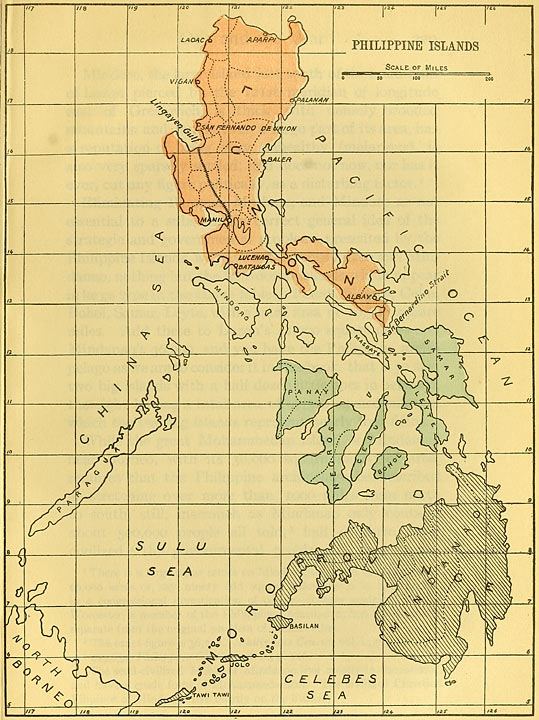
Bird’s-eye view of the Philippine Archipelago, showing the preponderating importance of Luzon.
For greater details, see folding map at end of volume.
Eliminating Paragua, Masbate, and Mindoro as not essential to a substantially correct general idea of the strategic and governmental problems presented by the Philippine Islands, we have left, besides Luzon and Mindanao, nothing but the half-dozen islands which appear in large type in the above table: Panay, Negros, Cebu, Bohol, Samar, Leyte, with a total area of 20,500 square miles. Add these to Luzon’s 41,000 square miles and Mindanao’s 36,000, and you have the Philippine archipelago as we are to consider it in this book, that is to say, two big islands with a half dozen little ones in between, the eight having a total area of 97,500 square miles, of which the two big islands represent nearly four-fifths.
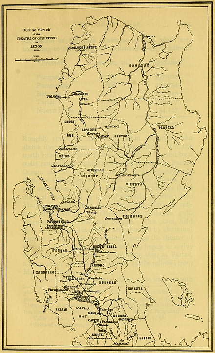
Outline sketch of the theatre of operations in Luzon, 1899.
Roughly speaking, the central plain comprising the above five provinces is bounded as follows: On the north by mountains and Lingayen Gulf, on the east by a coast range of mountains separating it from the Pacific Ocean, on the west by a similar range separating it from the China Sea, and on the south by Manila Bay and mountains. The Rio Grande de Pampanga flows obliquely across it in a southwesterly direction into Manila Bay, and near its western edge runs the railroad from Manila to Dagupan on Lingayen gulf. Dagupan is 120 miles from Manila. This plain, held by a well-equipped insurgent army backed by the moral support of the whole population, became the theatre of war as soon as the volunteers of 1899 began to arrive at Manila, the insurgent capital being then at Tarlac, a place about two-thirds of the way up the railroad from Manila to Dagupan.
Of course the first essential thing to do was to break the backbone of the insurgent army, and scatter it, and the next thing to do was to capture Aguinaldo, the head and front of the whole business, the incarnation of the aspirations of the Filipino people. The operations to this end commenced in October, and involved three movements of three separate forces:
(1) A column under General Lawton, proceeding up the Rio Grande and along the northeastern borders of the plain, and bending around westward along its northern boundary toward the gulf of Lingayen, garrisoning the towns en route, and occupying the mountain passes on the northeast which give exit over the divide into the great valleys beyond.
(2) An expedition under General Wheaton, some 2500 in all, proceeding by transports to the gulf of Lingayen, the chief port of which, Dagupan, was the northern terminus of the railroad; the objective being to land on the shore of that gulf at the northwest corner of the plain, occupy the great coast road which runs from that point to the northern extremity of the island, and also to proceed eastward and effect a junction with the Lawton column.
(3) A third column under General MacArthur, proceeding up the railroad to the capture of Tarlac, the third insurgent capital, and thence still up the railroad to its end at Dagupan, driving the enemy’s forces before it toward the line held by the first two columns.
On October 12th, General Lawton moved up the Rio Grande from a place called Aryat, a few miles up stream from where the railroad crosses the river at Calumpit, driving the insurgents before him to the northward and westward. His command was made up mainly from the 3d Cavalry and the 22d Infantry, together with several hundred scouts, American and Maccabebee. On the 20th San Isidro was again captured. That was the place Lawton had evacuated in May previous. Arriving in the Islands with Colonel E. E. Hardin’s regiment, the 29th U. S. Volunteer Infantry, on November 3, 1899, the writer was immediately detailed to the Maccabebee scouts, to take the place of Lieutenant Boutelle, of the regular artillery, a young West Pointer from Oregon, who had been killed a day or two previous, and reported to Major C. G. Starr, General Lawton’s Adjutant-General in the field (whom he had known at Santiago de Cuba the previous year) at San Isidro on or about November 8th. Major Starr said: “We took this town last spring,” stating how much our loss had been in so doing, “but, partly as a result of the Schurman Commission parleying with the insurgents General Otis had us fall back. We have just had to take it again.” General Lawton garrisoned San Isidro this time once for all, and pressed on north, capturing the successive towns en route. Meantime, General Young’s cavalry, and the Maccabebee scouts under Major Batson, a lieutenant of the regular army, and a medal-of-honor graduate of the Santiago campaign, were operating to the west of the general line of advance, striking insurgent detachments wherever found and driving them toward the line of the railroad. By November 13th, Lawton’s advance had turned to the westward, according to the concerted plan of campaign above described, garrisoning, as fast as they were taken, such of the towns of the country over which he swept as there were troops to spare for. We knew that Aguinaldo had been at Tarlac when the advance began, and every officer and enlisted man of the command was on the qui vive to catch him. By November 18th, General Lawton’s forces held a line of posts extending up the eastern side of the plain, and curving around across the northern end to within a few miles of the gulf of Lingayen.
After General Lawton had finished his part of the round-up, he had a final conference with General Young on November 18th at Pozorubio, which is near the northeastern border of the plain, bade him good-bye, and soon afterward went south to dispose of a body of insurgents who were giving trouble near Manila. It was in this last expedition that he lost his life at San Mateo about twelve miles out of Manila on December 19, 1899.
The first of the two purposes of the great Wheaton-Lawton-MacArthur northern advance, viz., the dispersion of the insurgent army of northern Luzon had been duly accomplished. The other purpose had failed of realization. Aguinaldo had not been captured. He escaped through our lines.
This had been the plan from the beginning, the council of war simply determining that the time to put the plan into effect had arrived. Accordingly, the uniformed insurgent battalions and regiments broke up into small bands which maintained a most persistent guerrilla warfare for years thereafter. During those years they seldom wore uniforms, disappearing and hiding their guns when hotly pursued, and reappearing as non-combatant peasants interrupted in agricultural pursuits, with invariable protestations of friendship. Hence all such came to be known as amigos (friends), and the word amigo, or friend, became a bitter by-word, meaning to all American soldiers throughout the archipelago an enemy falsely claiming to be a friend. And every Filipino was an “amigo.”
It is gratifying to know that as our troops got away from the immediate vicinity of Manila they found the natives of the country exceedingly friendly * * *. This was doubtless due in some measure to the fact that the Pampangos, who inhabit the provinces of Pampanga and Tarlac, and the Pangasinanes, who inhabit Pangasinan, as well as the other more northerly tribes, are unfriendly to the Tagalogs, and had simply submitted to the military domination of that tribe, from which they were glad to be relieved.
In characterizing this as nonsense no disrespect is intended to Mr. Root. He did not know any better. He was relying on General Otis. But it is sorely difficult to convey in written words what utter nonsense those expressions about “the Pampangos” and “the Pangasinanes” are to any one who was in that northern advance in the fall of 1899. Imagine a British cabinet minister making a report to Parliament in 1776 couched in the following words, to wit:
The Massachusetts-ites, who inhabit Massachusetts, and the Virginia-ites who inhabit Virginia, as well as most of the other inhabitants are unfriendly to the New York-ites, and have simply submitted to the military domination of the last named,
and you have a faint idea of the accuracy of Mr. Root’s report. It is quite true that the Tagalos were the prime movers in the insurrection against us, as they had been in all previous insurrections against Spain. But the “Tagalo tribe” was no more alone among the Filipino people in their wishes and views than the “unterrified” Tammany tribe who inhabit the wilds of Manhattan Island, at the mouth of the Hudson River, are alone in their views among our people.
General Gregorio Pilar, killed at the battle of Tila Pass, December 2d, 1899, commanding Aguinaldo’s rear-guard. An officer and a gentleman. (Signed) D. P. Quinlan, 2d Lieutenant, 11th Cavalry.
The brief incident over, Quinlan hurried on, rejoined the column, and resumed the work of Benevolent Assimilation and the war against Home Rule with all the dauntless ardor of his impetuous Irish nature. Whatever the ultimate analysis of the ethics of this scene—Quinlan at the grave of Pilar—clearly the Second Lieutenant Quinlan of 1899 would hardly have agreed with the vice-presidential candidate of 1900, Colonel Roosevelt, that granting self-government to the Filipinos would be like granting self-government to an Apache reservation under some local chief.
The area and population of the territory occupied by General Young, the “First District of the Department of Northern Luzon,” was, according to the Census of 1903, as follows:
The rest of the story of the northern campaign of 1899–1900 immediately following Aguinaldo’s escape into the mountains through General Young’s and General Lawton’s lines, being a necessary part of the American occupation of the Philippines, may also serve as a text for further acquainting the reader with the geography of Luzon. War is the best possible teacher of geography, and it may be well to communicate in broken doses, as we received them, the lessons on the subject which the 8th Army Corps learned in 1899 and the subsequent years so thoroughly that we could all pronounce with astonishing glibness, the most unpronounceable names imaginable.
Having now followed the “far-flung battle line” of the volunteers of ’99 and their comrades in arms, the regulars, from Manila northward across the rice paddies of central Luzon and over the mountains to the northern extremity of the island, let us return to the central plain, for reasons which will be stated in so doing. Between the China Sea and the coast range which forms the western boundary of the central plain of Luzon, there is a long strip of territory—a west wing of the plain, as it were—about 125 miles long, with an average width of not more than twenty miles, stretching from Manila Bay to Lingayen Gulf. This is divided, for governmental purposes into two provinces, Bataan on the south, whose southern extremity lay on Admiral Dewey’s port side as he entered Manila Bay the night before the naval battle of May 1, 1898, and Zambales on the north. The area and population of this territory are as follows:
Province Area (sq. m.) Population
Bataan 537 46,787
Zambales 2,125 104,549
2,662 151,336
General Smith’s district, the Third, comprised the provinces of
Province Area (sq. m.) Population
Zambales 2,125 104,549
Pangasinan 1,193 397,902
Tarlac 1,205 135,107
4,523 637,558
Pangasinan with its near 400,000 people is the largest, in point of population, of the twenty-five provinces of Luzon, and the third largest of the archipelago.
General Funston’s district, the Fourth, comprised the provinces of
General Grant’s district, the Fifth, comprised the provinces of
Province Area (sq. m.) Population
Bataan 537 46,787
Pampanga 868 223,754
Bulacan 1,173 223,742
2,578 494,283
2,500 150,000
Totals, 4th and 5th Districts: 5,078 644,283
It will be seen from the foregoing that the Third District was nearly equal in area to the Fourth and Fifth added together, and that the same was true as to its population figure.
State Area (sq. m.) Population
Ilocos 6,500 650,000
Cagayan 12,000 300,000
Pangasinan 4,500 625,000
Pampanga 5,000 650,000
28,000 2,225,000
It may surprise the reader after all the blood and thunder to which his attention has hereinabove been subjected, apropos of northern Luzon and the winter of 1899–1900, to know that the insurgents were still bearding the lion in his den, i. e., General Otis in Manila, by operating in very considerable force in the village-dotted country within cannon-shot of the road from Manila to Cavite in January, 1900. Nevertheless such was the case.
On the 4th of January, 1900, General J. C. Bates was assigned to the command of the First Division of the Eighth Army Corps, General Lawton’s old division, and an active campaign was commenced in southern Luzon. The plan adopted was that General Wheaton with a strong force should engage and hold the enemy in the neighborhood of Cavite, while General Schwan, starting at the western horn of the half moon to which the great lake called Laguna de Bay has already been likened, should move rapidly down the west shore of the lake, and around its south shore to Santa Cruz near its eastern end, or horn, garrisoning the towns en route, as taken, instead of leaving them to be re-occupied by the insurgents. Santa Cruz is the same place where General Lawton had “touched second base,” as it were, with a flying column in April, 1899.
This plan was duly carried out. The Schwan column started from San Pedro Macati, the initial rendezvous, a few miles out of Manila, on January 4, 1900, now garrisoning the towns en route, instead of leaving them to be fought over and captured again as heretofore. The first stiff fight we had in that campaign was at Biñan, on January 6, 1900, one of the places General Lawton’s expedition had taken when he fought his way over the same country the year before. O. K. Davis and John T. McCutcheon, who were in that fight and campaign—in fact one of them had the ice-cold nerve to photograph the Biñan fight while it was going on, as I learned when we all went down to the creek near the town, after we took it, to freshen up—can testify that we did not then hear any nonsense about a “Tagal” insurrection, such as Secretary of War Root’s Report for 1899, published shortly before, is full of, and that on the contrary the whole country was as much a unit against us and as loyal to the Aguinaldo government as northern Luzon had been. And inasmuch as I am doing some “testifying” along here myself, and assuming to brush aside without the slightest hesitation, as wholly erroneous, information conveyed to the American public at the time in the state papers of President McKinley and Secretary of War Root, it is only due the reader, whose attention is being seriously asked, that “the witness” should “qualify” as to the opportunities he may have had, if any, to know whereof he speaks, concerning the character of the opposition. To that end, the following document, which General Schwan was kind enough to send me afterwards, is submitted as sent:
EXTRACT COPY.
Headquarters Detachment Macabebe Scouts. The Adjutant General, Schwan’s Expeditionary Brigade:
Sir: I have the honor to submit the following report of the operations of the Detachment of Macabebe Scouts, under my command, while forming a part of your Brigade.
The Detachment, consisting of five (5) officers and one hundred and forty (140) men, was divided into two companies, commanded by 1st Lt. J. Lee Hall, 33rd Inf., and 1st Lt. Blount, 29th Inf., left San Pedro Macati the afternoon of Jan. 4th, 1900 * * *.
I wish to invite your attention, especially, to the good work done in the fight at Biñan by Lieut. Blount, 29th Inf., who led the line by at least twenty-five yards * * *.
Very Respectfully, Wm. C. Geiger, 1st Lt. 14th Inf., Com’d’g Det.
I hereby certify that the above is a true copy of extracts from the report of the operations of the Detachment of Macabebe Scouts forming part of an Expeditionary Brigade under my command, in the months of January and February, 1900.
Theo. Schwan, Brig. General, U. S. Vols. Aug. 16, 1900.
The activities of Generals Bates and Wheaton, and the Schwan Expedition of January-February, 1900, extended the American occupation, so far as there were troops enough immediately available to go around, over the lake-shore portions and the principal towns of the two great provinces of southern Luzon bordering on the Laguna de Bay, viz., Cavite and Laguna; and over parts of the two adjacent provinces of Batangas and Tayabas.
Batangas bounds Cavite on the south, and is itself bounded on the south by the sea, where a fairly good port offered a fine gateway for smuggling arms into the interior from abroad. Tayabas province adjoins Laguna on the southeast. Cavite province has always been, since the opening of the Suez Canal, about 1869, and the agitations for political reform in Spain which culminated in the Spanish republic of 1873, quickened the thought of Spain’s East Indies, the home of insurrection, the breeding place of political agitation. Aguinaldo himself was born within its limits in 1869. Laguna province comprehends most of the country lying between the southern and eastern lake-shore of the Laguna de Bay and the mountains which skirt that body of water in the blue distance, all parts of it being thus in easy and safe touch by water transportation by night with Cavite, the home and headquarters of insurgency.
Province Area (sq. m.) Population
Cavite 619 134,779
Batangas 1,201 257,715
Laguna 629 148,606
Tayabas 5,993 153,065
8,442 694,165
For convenience of subsequent allusion, this group of provinces may be treated as representing roughly 8500 square miles of territory and 700,000 people. These four provinces group themselves together naturally from a military standpoint. As physical force is the final basis of all government, these four provinces constitute a logical administrative governmental unit, as shown by the action of our military authorities in their extension of the American occupation. It would seem therefore that if there should ever be a Philippine republic, they would probably constitute one of its states—the State, let us say, of Cavite.
For convenience of subsequent allusion, these three provinces of the hemp peninsula which constituted the Third Military District of the Military Department of Southern Luzon in 1900, may be regarded as comprising, roughly, 6000 square miles of territory and 600,000 people. If the Philippine republic of the future which is the dream of the Filipino people, prove other than an idle dream, the hemp peninsula will probably some day constitute a state of that republic, an appropriate and probable name for which would be the State of Camarines.
In volume i., part 5, War Department Report, 1899, at pages 5 et seq., may be found a journal illustrating the nature of the “police” work done by the volunteers of 1899, in 1900, and at pages 5 et seq. of the same report for 1900 (volume i., part 4) may be found a similar diary carried up to June 30, 1901. Throughout the period covered by those reports, scarcely a day passed without what the military folk coolly call “contacts” with the enemy.
The Visayan Islands were in course of time duly organized, as Luzon had previously been, departmentally and by military districts. The Visayan Islands became the Department of Visayas, divided into districts commanded either by regimental commanders having a regiment or more with them, or by general officers. For a long time no attempt to make military occupation effective in these various islands, save in the coast towns, was attempted. However, the indicated disposition of troops completed, technically at least, the American occupation of the Visayan Islands.
Pursuant to the plan followed, as we have hitherto followed the army in our narrative, first throughout northern Luzon and later through southern Luzon, some data are now in order concerning the Visayan Islands.
Island Area (sq. m.) Population
Panay 4,611 743,646
Negros 4,881 460,776
Cebu 1,762 592,247
Leyte 2,722 356,641
Samar 5,031 222,090
Bohol 1,441 243,148
Whenever, if ever, an independent republic is established in the Philippines, the six islands above mentioned could and should constitute self-governing commonwealths similar to the several States of the American Union. The rest of the islands lying between Luzon and Mindanao could easily be disposed of governmentally by being attached to the jurisdiction of one of the said six islands.
Mindanao and the adjacent islets called Jolo were organized as the Department of Mindanao and Jolo, under General Kobbe, with the 31st Volunteer Infantry, Colonel Pettit’s regiment, the 40th Volunteer Infantry, Colonel Godwin’s regiment, and the 23rd Regular Infantry. Thus the archipelago was completely accounted for, for the time being, just as all the territory of the United States was long accounted for by our military authorities at home, with the Department of the East, headquarters Governor’s Island, New York; the Department of the Lakes, headquarters Chicago; the Department of the Gulf, headquarters Atlanta, etc. In this state of the case, General Otis re-embraced his early pet delusion—if it was a delusion, which charity and the probabilities suggest it should be called—about the insurrection having gone to pieces; and decided to come home. Possibly, also, he was homesick. General Otis was a very positive character, a strong man. But even strong men get homesick after long exile. When you hear the call of the homeland after long residence “east of Suez,” you must answer the call, duty not forbidding. General Otis had stood by his ink wells and the Administration with unswerving devotion for twenty months, and was entitled to come back home and tell the public all about the fighting in the Philippines, and how entirely over it was, and how wholly right Mr. McKinley was in his theory that the visible opposition to our rule and the seeming desire to be free and independent did not represent the wishes of the Filipino people at all, but only the “sinister ambitions of a few unscrupulous Tagalo leaders.” Accordingly on May 5, 1900, he was relieved at his own request, and departed for the United States. He was succeeded in command by a very different type of man, Major-General Arthur MacArthur, upon whom now devolved the problem of holding down the situation and of actually getting it stably “well in hand” by June 30, 1901, the date of expiration of the term of enlistment of the twenty-five volunteer regiments organized under the Act of March 2, 1899.