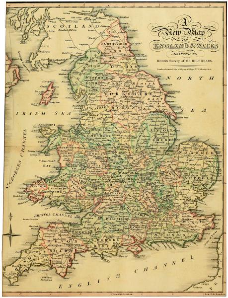
Survey of the High Roads of England and Wales. Part the FirstA New Map OF England & Wales ADAPTED TO Mogg’s Survey of the High Roads. London, Published May 1st. 1817 by E. Mogg. No. 51, Charing Cross.Reading editionChapter navigation12 reading sectionsGo to chapterChoose a chapter…Front matterSURVEY OF THE HIGH ROADS OF England and Wales.ADVERTISEMENT.TABLE OF ROUTES.INDEX TO THE COUNTRY SEATS.INDEX TO THE COUNTRY SEATS. (continued 2)GENERAL AND TOPOGRAPHICAL INDEX TO THE DIRECT AND CROSS ROADS CONTAINED IN THIS WORK. COMPREHENDING ALL THE CITIES, BOROUGHS, MARKET TOWNS, VILLAGES, POST STAGES, AND OTHER REMARKABLE OBJECTS, WHETHER SITUATED ON, OR CONTIGUOUS TO, THE ROAD, WITH A DESCRIPTION OF EACH, TOGETHER WITH THE DISTANCE OF THE SAME FROM LONDON.GENERAL AND TOPOGRAPHICAL INDEX TO THE DIRECT AND CROSS ROADS CONTAINED IN THIS WORK. COMPREHENDING ALL THE CITIES, BOROUGHS, MARKET TOWNS, VILLAGES, POST STAGES, AND OTHER REMARKABLE OBJECTS, WHETHER SITUATED ON, OR CONTIGUOUS TO, THE ROAD, WITH A DESCRIPTION OF EACH, TOGETHER WITH THE DISTANCE OF THE SAME FROM LONDON. (continued 2)GENERAL AND TOPOGRAPHICAL INDEX TO THE DIRECT AND CROSS ROADS CONTAINED IN THIS WORK. COMPREHENDING ALL THE CITIES, BOROUGHS, MARKET TOWNS, VILLAGES, POST STAGES, AND OTHER REMARKABLE OBJECTS, WHETHER SITUATED ON, OR CONTIGUOUS TO, THE ROAD, WITH A DESCRIPTION OF EACH, TOGETHER WITH THE DISTANCE OF THE SAME FROM LONDON. (continued 3)DIRECTIONS TO THE BINDER.A New Map OF England & Wales ADAPTED TO Mogg’s Survey of the High Roads. London, Published May 1st. 1817 by E. Mogg. No. 51, Charing Cross.Transcriber’s NotesPrevious chapter ←DIRECTIONS TO THE BINDER.Next chapter →Transcriber’s NotesAll chapters and sections (12)Opening pagesFront matterOther sectionsSURVEY OF THE HIGH ROADS OF England and Wales.ADVERTISEMENT.TABLE OF ROUTES.INDEX TO THE COUNTRY SEATS.INDEX TO THE COUNTRY SEATS. (continued 2)GENERAL AND TOPOGRAPHICAL INDEX TO THE DIRECT AND CROSS ROADS CONTAINED IN THIS WORK. COMPREHENDING ALL THE CITIES, BOROUGHS, MARKET TOWNS, VILLAGES, POST STAGES, AND OTHER REMARKABLE OBJECTS, WHETHER SITUATED ON, OR CONTIGUOUS TO, THE ROAD, WITH A DESCRIPTION OF EACH, TOGETHER WITH THE DISTANCE OF THE SAME FROM LONDON.GENERAL AND TOPOGRAPHICAL INDEX TO THE DIRECT AND CROSS ROADS CONTAINED IN THIS WORK. COMPREHENDING ALL THE CITIES, BOROUGHS, MARKET TOWNS, VILLAGES, POST STAGES, AND OTHER REMARKABLE OBJECTS, WHETHER SITUATED ON, OR CONTIGUOUS TO, THE ROAD, WITH A DESCRIPTION OF EACH, TOGETHER WITH THE DISTANCE OF THE SAME FROM LONDON. (continued 2)GENERAL AND TOPOGRAPHICAL INDEX TO THE DIRECT AND CROSS ROADS CONTAINED IN THIS WORK. COMPREHENDING ALL THE CITIES, BOROUGHS, MARKET TOWNS, VILLAGES, POST STAGES, AND OTHER REMARKABLE OBJECTS, WHETHER SITUATED ON, OR CONTIGUOUS TO, THE ROAD, WITH A DESCRIPTION OF EACH, TOGETHER WITH THE DISTANCE OF THE SAME FROM LONDON. (continued 3)DIRECTIONS TO THE BINDER.A New Map OF England & Wales ADAPTED TO Mogg’s Survey of the High Roads. London, Published May 1st. 1817 by E. Mogg. No. 51, Charing Cross.Transcriber’s NotesLarger map (600 kB)◇← DIRECTIONS TO THE BINDER.Transcriber’s Notes →