Introductory material (continued 5)
Reading edition
The only explanation which can be given for this manner of building is, that most boatmen have their own tow horses, for which a stable is placed at the centre of the boat, so that they do not notice the additional costs of towing which they have to pay.
The dimensions of Tournai boats and of the chalands are the same; their length varies from 37.50 m. to 39 metres, not counting the rudder, and their breadth goes from 5.00 m. to 5.05 m.; they draw empty, on an average, 0.28 m., and when loaded from 1.80 m. to 2.30 m., with a tonnage of 300 to 370 tons.
By comparing the bélandres and pointus with these boats, it can be seen that the latter can carry less than the former on account of their finer bow, whence their name of Pointu or Spits.
The essential difference between the “bélandre”, called in Flemish Bijlander, and the “pointu” lies in this, that the bottom of the former connects with the forward face by means of a curved surface, whereas the bottom of the latter remains flat up to the nose. The two types differ little in other respects. They are rarely built now. It is true that new “pointus” are still met with, but they should be considered rather as bastard “péniches”. Here again is seen a fusion of different forms accompanying an increase in the size of the boats.
The “bélandres” are 28 to 34 metres long, 4.60 m. to 5 metres broad and draw 0.30 m. to 0.40 m. light and up to 2 metres loaded.
The “pointu” is 20 to 30 metres long and generally 3.50 m. broad (never reaching 5 metres); it draws light, on an average, 0.35 m., and 1.80 m. when loaded. Its tonnage is from 100 to 200 tons.
The largest pointus measure 32 metres in length and 4.90 m. in breadth; they gauge at most 250 tons on a draught of 2.15 m.
Many of the types just mentioned are now often built of steel.
The “Prij” should also be mentioned in the chapter relating to these boats; it is a “spits” made in two distinct parts, each of which can be loaded separately.
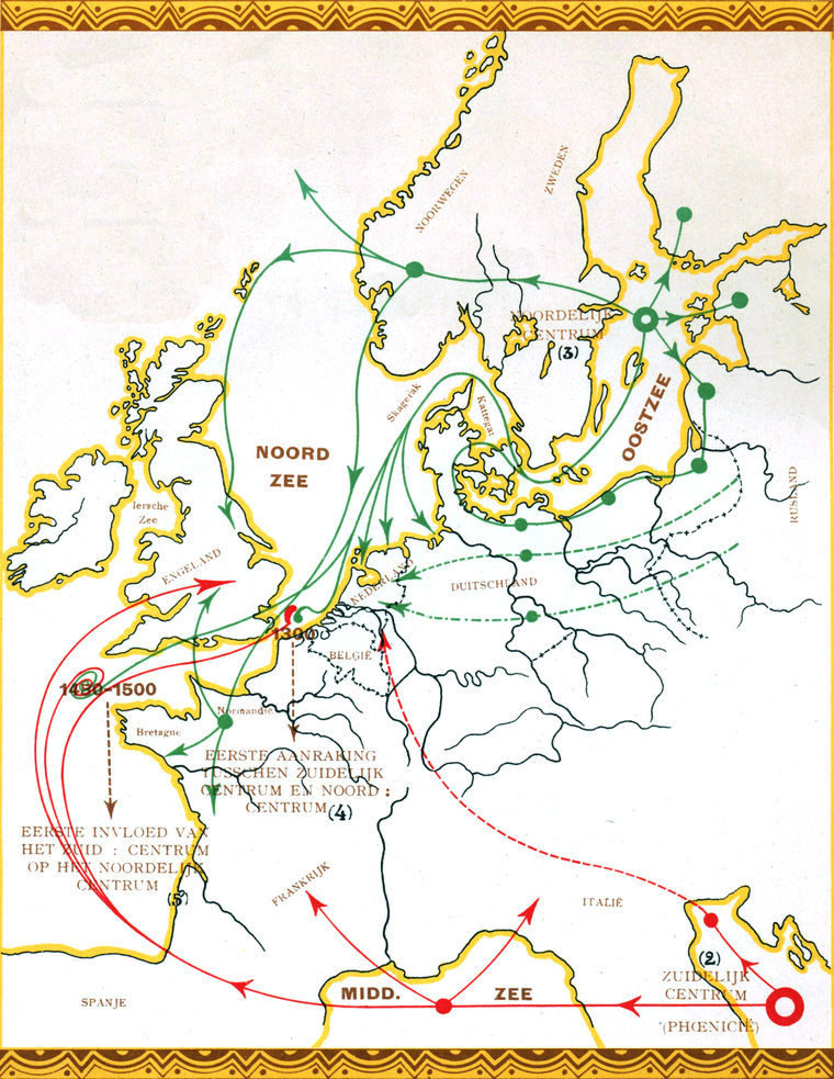
Shipbuilding in Europe developed around two centres which came into contact in the neighborhood of 1300. The fusion of the two zones took place only between 1450 and 1500.
The Northern centre, that of the Baltic Sea, which had its origin in Sweden and Norway, only reached its full expansion in the time of the Vikings. The types of boats of the various nations along the shores of the seas of the North of Europe show undeniable analogies both in form and in mode of construction.
Going further into the continent, the same striking analogies still appear, so that the likeness of forms is further strengthened along the East-West line.
Map No 1 herewith shows in green the sphere of the Northern centre; the probable direction of the movement of the rounded Frisian types being given by a full line, the direction of the finer types by a dotted line and that of the types of the Lower Rhine by a broken and dotted line.
The Southern centre, situated in the Mediterranean, and originally from Phœnicia, is marked in red. There too, shipbuilding developed along an East-West line. Although it may not be certified, from the nautical standpoint or with the data at hand, that the Southern centre was under the influence of Asia, it can be observed, however, that many forms and processes of construction noted in old engravings are still found in the Arab, Indian and Chinese vessels.
Hence it follows that it is all the more necessary to carry on our investigations in that direction because the old methods of propulsion and of steering have been relatively well preserved in Asia rather than in Europe.
There is no doubt that relations in connection with this subject will be found between the Southern centre and a part of Asia.
Shipbuilding, which came to us from the Baltic Sea, was first put to use for fishing, that undoubted cradle of every great maritime race. The gradual growth of this industry widened the field of action and favored trade as it did in the Flanders. Hence, there will be no cause for astonishment in finding that the oldest memories of Holland in reference to shipbuilding are those of the herring fishery.
The birth of the cog, for example, is due to the rise of this kind of fishing; then this type of vessel led to that of the “Egmonderpink”, and afterward to that of the “Bom”, which will very soon have disappeared and of which it may be said that it will have formed the last vestige of the “Cog”.
The whole evolution of the ship is founded, furthermore, on tradition. This, however, did not lie alone in servile imitation of all that our ancestors had turned out, but in yielding to new demands which the special conditions of the period brought with them.
The evolution of the ship, like that of its size, has been gradual. So the ships of antiquity were smaller than those of the Middle Ages, and these in their turn were smaller than the vessels of modern times.
Neither the compass, the adoption of the rudder nor even the invention of gunpowder were able to bring about sudden changes in naval architecture. It was only gradually, and through improvements in artillery, that ships became heavier; so that at the beginning of our war for independence the distinction had begun to be made between war vessels and merchantmen, which until then had both been equally used for military purposes.
It was after the discovery of America and of the route to the East Indies, two events of the greatest importance for the evolution of the peoples of Europe, that the commerce of the world left the Mediterranean and moved toward the North Sea. Then it was that our country woke up and soon surpassed all others in shipbuilding. The Netherlands then carried naval construction back toward the Baltic.
France also borrowed from us the elements of shipbuilding. The province of Holland was at the head of this branch of construction from 1500 to 1700; France then took Holland’s place and, from the middle of the XVIIIth century, had its own separate construction. It was the keen French mind which guided all countries in the systematic construction of ships.
England, always practical, has ever done her best to keep up with the country which turned out the largest ships. HOLMES’s work shows this tendency clearly. After 1800, England outstripped her rivals and set the pace for naval architecture. Numerous improvements were carried out under the influence of that country.
The continental blockade dealt our shipbuilding a mortal blow. It was only through the initiative and the energetic backing of King William I that the industry revived in the first half of the XIXth century and reached, in the second half, a new period of prosperity. Japan’s first modern war vessels were built in Holland.
The coming of steel opened a new era for our naval architecture and our worthy shipbuilders have been able to do honor to the traditions of our race by proving themselves now, as formerly, economical architects with the ability to give a pleasing appearance and an irreproachable finish to a solid construction.
The distribution of the groups of the various types of boats is shown on map 3, while map 4 gives the subdivision of these groups in the Netherlands.
The Frisian types appear on both these maps in blue; the types of the Lower Rhine, which penetrated into the North-West of Brabant and into the heart of South Holland, are given in brown; the types of the Upper Rhine are in violet, those of the Lower Meuse in red and those of the Upper Meuse in green. The types with finer lines of Overijssel, surrounded by those from Friesland and the Lower Rhine, and which are also met with on the Ems, the Weser, the Elbe, the Havel and the Spree are shown with a paler shade.
Chart No. 4 shows the zone of the fishing boats which frequent the North Sea. These last, except the “Lugger” and the “Sloop”, belong to the Friesland type. It is curious to bring the boundaries of charts 5, 6 and 7 together, containing, as they do, the results of the patient researches of the late Professor Dr. Gallée, so well known and esteemed for his vast learning as well as for his great kindness, when, some time ago, he was so good as to place copies of these charts at the author’s disposal.
A mere glance is sufficient to show that the limits of costumes have been most changed; but, on the contrary, there is a striking resemblance from the point of view of the distribution of languages and, especially, from that of the kind of dwellings.
The Frisian and Saxon influences agree on the different charts, while the types of the Upper Meuse are found everywhere that the architecture of the Roman villas has been preserved. Hence it is not astonishing that these types of the Meuse resemble those found in the valley of the Po and on the Adriatic Sea.
These observations agree with the historical researches which, have established the fact that the countries bordering on the North Sea were inhabited by the Celts who came from the East to Central and Western Europe several centuries before our era. The Celts drove out the Mongols, who were already settled there; but they, in their turn, were driven from the West by the Germans. This is what caused the Romans to say that, north of the Rhine, the Celts had already been driven out everywhere by the Germans. The Rhine was at that time the general boundary line between the two peoples. South of this river there only a few German out-lying positions, like those of the Eburones at Maestricht and Roermond, and of the Condrosii near Liége. The Germans and Celts are confounded along the Meuse. The Celts in North Brabant had already become very much germanized, while the Menapii, the Morini and the Nervii of Flanders and Zeeland also felt this influence. All these germanized Celts were called Gauls by the Romans. The Germans penetrated several times into Gaul, they even came as far as the Menapian country in the valley of the Scheldt; but Cæsar succeeded in driving them back, in the year 55 B. C. After the latter’s conquests, the Rhine became the frontier of Roman domination and so remained until about the IXth century. The Gauls quickly became latinized. North of the Rhine, the Roman influence made itself felt on the Batavi, the Chamavi and the Frisians. Still, this influence was not very strong, especially on the last-named tribe. From the moment that the Roman power began to weaken, the Germans reappeared, and it was especially the Franks who proved to be the stronger. These latter, who inhabited the region of the Lippe, the Ruhr and the Upper Ems, were probably being pushed out already at this time by the Saxons. The Franks were again driven beyond the Rhine by the Emperor Probus, in 280, but they advanced again toward the South after the death of Constantine the Great (337). Cologne fell into their hands and they appeared in front of Treves. Julian prevented, however, their entering Taxandria, the present North Brabant.
The Salians, the strongest of the Franks, remained in the country of the Batavi while the Chamavi, another of their tribes, settled on the North of the Rhine. The Salians and Batavi soon consolidated into a single tribe. Then when the Romans retired in 402, during the reign of the Emperor Honorius, the Francs started again on their route toward the South and invaded North Brabant.
The Saxons who, as already mentioned, had probably started the Franks, inhabited the country lying between the Ems and the Elbe, consequently the North of Germany. They settled in the East of our country and, later, extended their influence northwardly.
The Frisians, who are generally spoken of in connection with the Saxons, were able to hold their ground between the Weser and the Zwin (Zeelandisch Flanders). Their King, Radbout, carried their domination to the South of the Rhine and pushed on even so far as Cologne where he was defeated by Charles Martel.
If Holland was called Frisia (or Friesland) in the Middle Ages, only as far as the mouth of the Meuse, it is related, on the other hand, that Saint Amand preached the Gospel to the Frisians of Zeeland. This tradition is confirmed by Prof. FOCKEMA ANDREA, who has shown that the Frisian law of 800 was applied from the Weser to the Zwin and the Frank law as far as the Ems, that is to say: the Chamavi inhabited the Veluwe to the East of this river; consequently Utrecht belonged to Frisia.
It is also said, in connection with the struggle of the Frisians against the Franks, that Utrecht was situated on the frontier of Frisia.
In a word, the Netherlands were inhabited originally by Celts whom the Germans drove toward the South. Later, they were able, with the assistance of the Romans, to hold their ground to the South of the big rivers of the country. The first Germans in Holland were the Frisians. They occupied the coast from the Weser to the Zwin and, at a few points, established themselves among the Celts.
Thus it is that Frisian types of vessels are found from Denmark to Flanders and that they penetrated as far as Utrecht and along the tidal rivers.
The Chamavi, the first Franks, very probably occupied the Veluwe and the Betuwe as for as the Singe and the Ems.
Later, the Franks, settled North Brabant and penetrated into Zeeland, Utrecht and South Holland. As a matter of fact, we have already been impressed at meeting, in our country, with types of boats of the Lower Rhine not only along the Rhine and its tributaries, but even in the heart of South Holland and in the North-West of North-Brabant.
The Saxons, who were the last to arrive, settled in the East of the country and spread gradually into Groningen and Friesland. It is there that the slender Overijssel or Saxon types are met with.
Types of vessels, just like the styles of dwellings, languages and costumes, have certain relationships with the first inhabitants of countries.
This explains why types of different boats are found along the same river and the same country.
So, old forms and old customs last through the ages and our country can pride itself not only on a glorious past but also on its ability to maintain so enviable a place in the domain of naval architecture, for the words that WITSEN wrote in 1671:
“In ’t overleg van een zuinig meester bestaet al ’t geheim van goedkoop bouwen.”[27]
can always be applied to our able builders of ships.
KAART No 1 Tafel No 1 — Carte No 1 Plate No 1 OP WELKE WIJZE DE SCHEEPSBOUW ZICH HEEFT VERPLAATST VOOR 1500(1) ⇒ LARGER IMAGE (1) Wie sich der Schiffbau vor 1500 bewegt hat. Evolution de l’architecture navale avant 1500. Way in which shipbuilding moved before 1500. (2) Südlicher Mittelpunkt. Centre méridional. Southern Centre. (3) Nördlicher Mittelpunkt. Centre septentrional. Northern Centre. (4) Erste Berührung zwischen dem südlichen und nördlichen Mittelpunkt. Premier contact entre le centre méridional et le centre septentrional. First contact between the Southern centre and the Northern centre. (5) Erster Einfluss des südlichen auf den nördlichen Mittelpunkt. Première influence du centre méridional sur le centre septentrional. First influence of the Southern centre on the Northern centre.
KAART N
o
2
Tafel N
o
2 — Carte N
o
2
Plate N
o
2
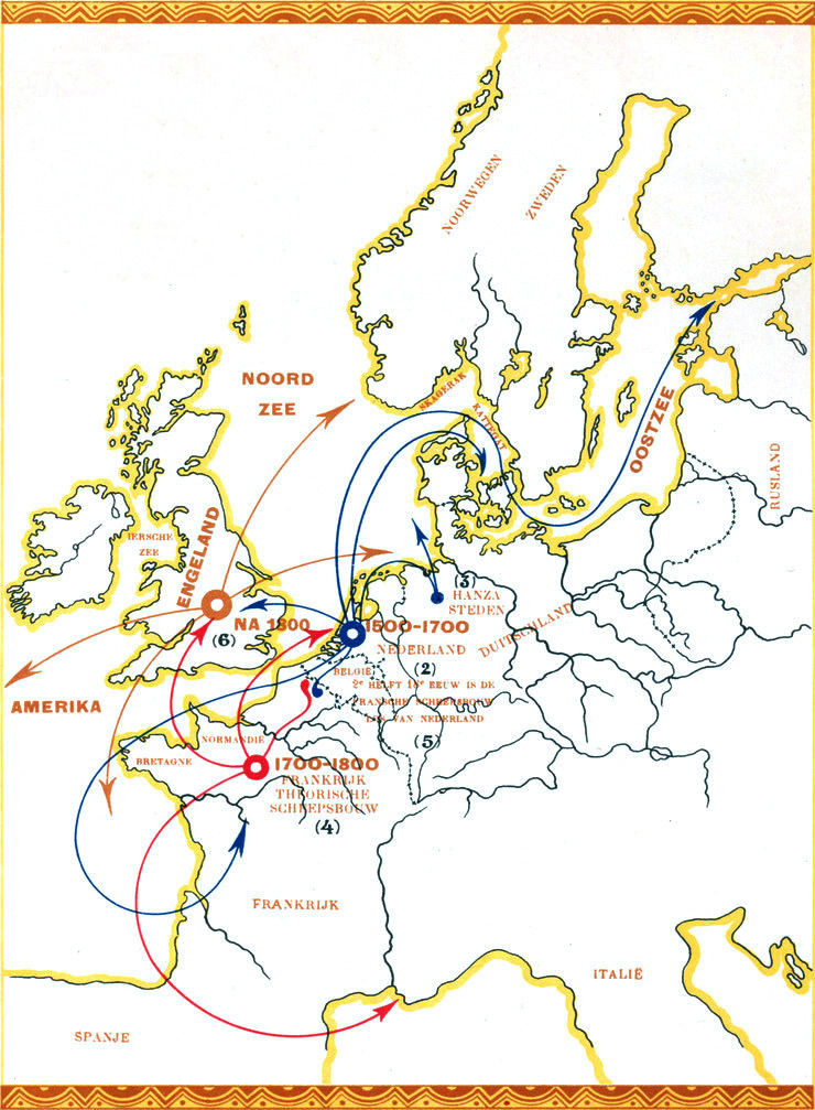
OP WELKE WIJZE DE SCHEEPSBOUW ZICH HEEFT VERPLAATST NA 1500(1)
⇒ LARGER IMAGE
(1) Wie sich der Schiffbau nach 1500 bewegt hat. Evolution de l’architecture navale après 1500. Way in which shipbuilding moved after 1500.
(2) 1500-1700. Niederlande. 1500-1700. Pays-Bas. 1500-1700. Netherlands.
(3) Städte des Hansabundes Villes de la ligue hanséatique. Cities of the Hanseatic League.
(4) 1700-1800. Frankreich. Der theoretische Schiffbau. 1700-1800. La France. L'architecture navale théoretique. 1700-1800. France. Theoretical shipbuilding.
(5) Die französische Bauweise trennt sich von der der Niederlande. L’architecture navale française se sépare de celle des Pays-Bas. French shipbuilding withdraws from that of the Netherlands.
(6) Nach 1800. England. Après 1800. L'Angleterre. After 1800. England.
KAART N
o
3
Tafel N
o
3 — Carte N
o
3
Plate N
o
3
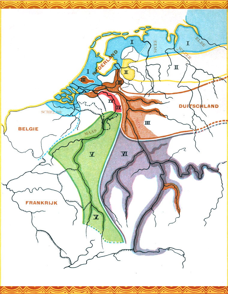
KAART DER SCHEEPSMODELLEN Tafel der Schiffstype. Carte des type de navires. Plate showing types of vessels.
⇒ LARGER IMAGE
Friesche modellen. (Smak, enz.) Friesische Type. (Smacken, u. s. w.) Frisons. (Semaque, etc.) Frisian types. (Smack, etc.)
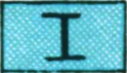
Overijselsche modellen. (Somp, pegge, enz.) Type von Overysel. (Somp, Pegge, u. s. w.) Types de l’Overysel. (Somp, pegge, etc.) Overysel types. (Somp, pegge, etc.)
(1) Rijn (Dorstensche aak). (2) der Rhein (Aak von Dorsten). (3) Le Rhin (l’Aque de Dorsten). (4) The Rhine (Ake from Dorsten).


Maas (Hedelsche aak). die Maas (Aak von Hedel). La Meuse (l’Aque de Hedel). The Meuse (l’Aque de Hedel).
Maas (Whale majol). die Maas (Whale majol). La Meuse (le Whale majol). The Meuse (The Whale majol).
Boven Rijn (Keen). der Oberrhein (der Keen). Le Rhin supérieur (le Keen). The Upper Rhine (Keen).
(1) Bovenlanders (2) Oberländer (3) Bovenlanders (4) Bovenlanders
KAART N
o
4
Tafel N
o
4 — Carte N
o
4
Plate N
o
4
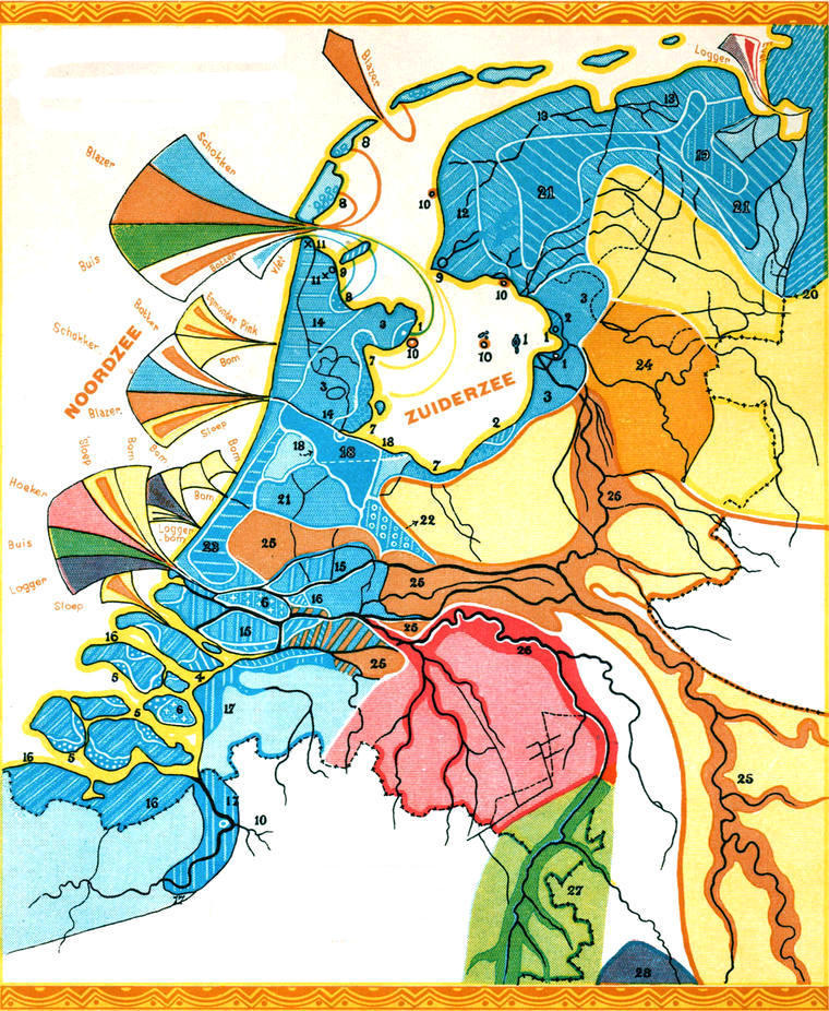
KAART DER SCHEEPSMODELLEN TAFEL DER SCHIFFSTYPE. CARTE DES TYPE DE NAVIRES. PLATE SHOWING TYPES OF VESSELS.
⇒ LARGER IMAGE
1 Fischereifahrzeuge Fishing boats Schokker, Schocker
2 Haringschuit, Heringschute Herring boat
3 Punter Gondel, etc.
4 Steekschuit, Steekschute Hengst
5 Hoogars
6 Tholensche Schouw, Tholensche Schauwe
7 Visschersvartuigen, Bateaux de pêche Botter
8 Blazer, Blaser
9 Stavorensche Jol, Stavorensche Jolle
10 Lemmerjacht, aak, Lemmeryacht, aak, Lemmerjacht, aque, Lemmerjacht, ake
11 Vlet, Flette
12 Smak, Schmacke, Semaque, Smack Smakgroup, Schmacken, Groupe de le Semaque, Smack group Binnenschiffe, Inland boats Binnenschepen, Bateaux d’intérieur
13 Tjalk, Tialque, Hoy
14 Yacht, Yacht
15 Schuit, Schute
16 Poon
17 Pleit
18 Kraak, Galleon
19 Kof, Koff, Koftjalk
20 Mot, Motte
21 Bok, etc.
22 Utrechtsche Praam, Praam von Utrecht, Prame d’Utrecht, Utrecht Pram
23 Westlander, Bok, etc.
24 Scherp model, Spitziger Typ, Type effilé, Tapered type Somp, Pegge, etc.

25 Rynmodel (Dorstensche aak), Rheintyp (Aak von Dorsten), Type rhénan (Aque de Dorsten), Rhenish type (Ake from Dorsten
26 Maasmodel (Hedelsche aak), Maastyp (Aak von Hedel), Type mosan (Aque de Hedel), Meuse type (Ake from Hedel)
27 Maasmodel, Maastyp, Type mosan, Meuse type Whalemajol
28 Maas-Rijnmodel, Maas-Rheintyp, Type mosan-rhénan, Meuse-Rhenish type Keen

De vaartuigen voor de grootvisscherij zijn in de teekening aangegeven.
Die Seefischereitype sind in der Tafel angedeutet.
Les type de la pêche maritime sont indiqués sur la carte.
This plate also shows the types for deap sea fishing.
KAART N
o
5
Tafel N
o
5 — Carte N
o
5
Plate N
o
5
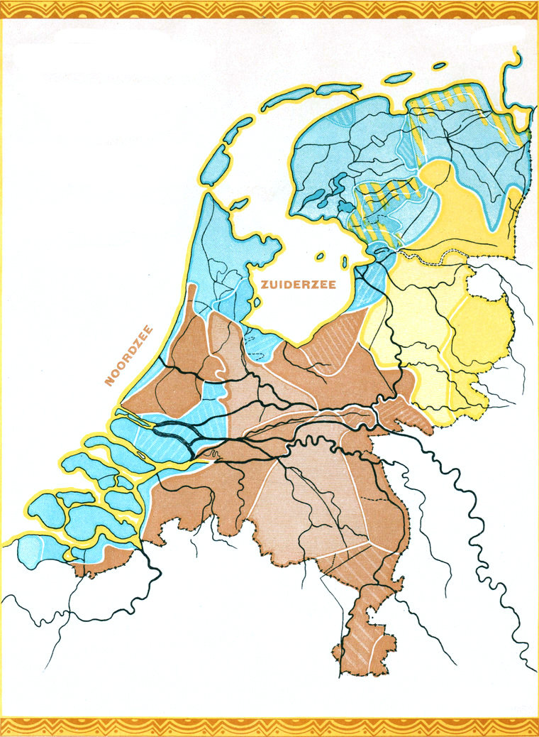
KAART DER DALECTEN. NEDERLAND. Dialecttafel. Niederlande. Carte des dialectes. Pays Bas. Dialect Chart. Netherlands.
Naar Prof. Dr Gallée
⇒ LARGER IMAGE
Friesche dialecten. Friesische Dialekte. Dialectes frisons. Frisian dialects.
Saksische dialecten. Sächsische Dialekte. Dialectes saxons. Saxon dialects.
Frankische dialecten. Fränkische Dialekte. Dialectes francs. Frankish dialects.
KAART N
o
6
Tafel N
o
6 — Carte N
o
6
Plate N
o
6
VOKLSKLEEDERDRACHTEN. Tafel der Volkstrachten. Carte des costumes nationaux. Plate of national costumes.
Naar Prof. Dr Gallée
⇒ LARGER IMAGE
Ooryzer en Friesch-Zeeuwsche knoop en slot. Ohrringe und Schliesshaken, friesisch-niederländisch. Boucle d’oreille et fermoir frison-zélandais. Dutch-Frisian earring and clasp.
Idem. Idem. Idem. Idem.
Utrechtsche muts. Haube von Utrecht. Bonnet d’Utrecht. Utrecht cap.

Kornet. Vroeger Twentsche muts. Haube, früher Haube von Twente. Cornette, jadis bonnet de Twenthe. Hood, formerly Twenthe cap.
Vlaamsche muts Keltisch ornament. Flämische Haube Keltischer Schmuck. Bonnet flamand Ornement celtique. Flemish cap Celtic ornament.
Brabantsche muts Brabanter Haube Bonnet brabançon Brabantine cap
Limburg. Limburg. Limbourg. Limbourg.
KAART N
o
7
Tafel N
o
7 — Carte N
o
7
Plate N
o
7
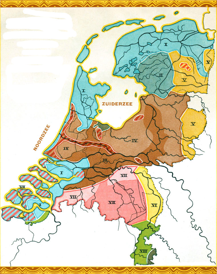
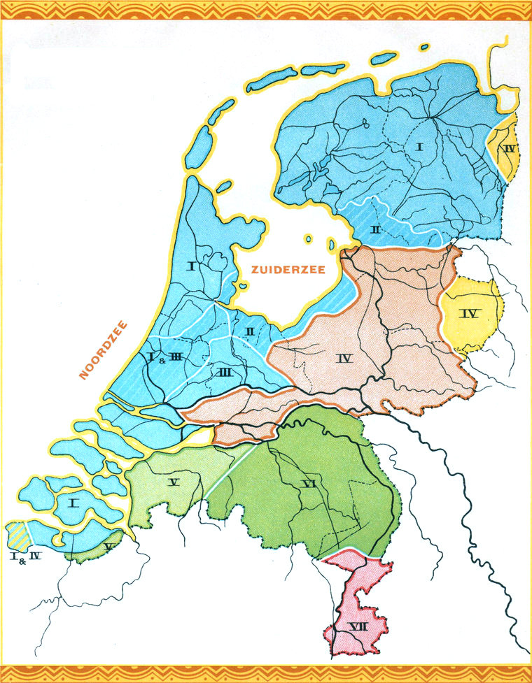
KAART DER BOERENWONINGEN. Tafel der ländlichen Wohnhäuser. Carte des habitations rurales. Country homes.
Naar Prof. Dr Gallée
⇒ LARGER IMAGE
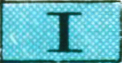
Friesch. Friesische. Frisonnes. Frisian.

Langhuis met Fr. hooiberging. Langhaus mit friesischem Heuboden. « Langhuis » avec grenier à foin frison. « Langhuis » with Frisian hayloft.
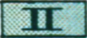
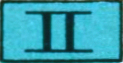
Rijn en Yssel ― Rhein-Yssel ― Rhin-Yssel ― Rhenish-Yssel ―
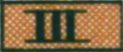

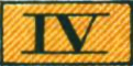
T. huis, vermengd met IV. Haus in T-Form verbunden mit IV. Maison en forme de T combinée avec IV. T-shaped house combined with IV.
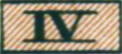
Twentsch. Haus von Twente. Maison de Twente. Twenthe house.
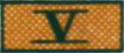
Langhuis met hooiberging boven in de schuur. Langhaus mit Heuboden über der Scheune. « Langhuis » avec grenier à foin au-dessus de la grange. « Langhuis » with hayloft above the barn.
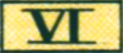
Brabantsche huis. Brabanter Haus. Maison brabançonne. Brabantine house.
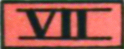
Romeinsche villabouw. Typ der römischen Villa. Type de la villa romaine. Type of Roman villa.
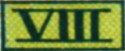
Idem naast het duitsche huis. Idem neben dem deutschen Wohnhause. Idem à côté de l’habitation allemande. Idem alongside of German dwelling.