PART II Main Thoroughfares
Reading edition
Width of Thoroughfares
In considering the economical widths for the main thoroughfares of a city, so many complex factors are involved that no exact and indisputable conclusions can be reached; but there are certain facts and principles that ought to remove such decisions from the realm of purely arbitrary whim and custom by which they are now generally settled. Practically every normal main thoroughfare, even of the most compact type, must provide for car tracks in the middle. On straight runs, according to the present practice and with the new cars in Pittsburgh, the width occupied from the outside of one car to the outside of the other is 17 feet 8½ inches. At that, the cars are narrower than the modern standard in some other American cities, and the clearance between the cars is reduced to less than a reasonable requirement for safety. On curving roads, such as the Pittsburgh topography often imposes, the space occupied is greater. Without allowing any clearance on the outside, a space not less than 18 feet, and preferably more, should be allowed for the actual cars on straight runs.
In Pittsburgh, the gauge of the car tracks was originally made to conform to the prevailing local gauge of other vehicles, on the mistaken theory that it was desirable to have the smooth tracks used by wagons; and this has resulted in the almost invariable conformity of the wagon gauge to that of the tracks, regardless of the size or character of the vehicle. With the added fact that Pittsburgh pavements are prevailingly bad, and that the form of rail is such that it is very difficult for a wagon to turn out when it has once got into the track, the teamsters in Pittsburgh are more inveterate in the habit of driving in the car tracks, and less ready to turn aside for cars or other vehicles, than in most cities. The severe and constantly repeated strain of the horses, which is required to wrench heavily-loaded wagons free from the tracks, is, in the aggregate, a serious economic loss; and the delays not only to the street cars but to all forms of wheeled traffic, caused by the conditions described, are incalculably great. But even good pavements and the use of a grooved rail would not cure the trouble in Pittsburgh streets as now laid out, because, almost universally, there is not sufficient room for a vehicle to pass between the cars and another vehicle standing or slowly moving next the curb.
In every street, vehicles must be free to stop for loading and unloading, and on a busy thoroughfare the space next the curb is so much used in this manner as to become merely a series of sidings into which slow-moving vehicles can turn from time to time in order to clear the main passageway. The result of the conditions above described is that practically the whole wheeled traffic in Pittsburgh streets is inevitably concentrated on the eighteen-foot width where the cars run. The extent to which this reduces the average speed of travel and the total capacity of the thoroughfare has been strikingly illustrated for Pittsburghers by the contrast of the former sluggish congestion of traffic on Smithfield Street with the sparse appearance and rapid movement of the same traffic since the "one-way" regulations have made it possible to get one free line in each direction for moving vehicles separate from the cars. The same striking increase in capacity is to be secured, without the grave inconveniences and drawbacks of the "one-way street" regulations, where the space between the cars and the curb can be made wide enough for two lines of vehicles, instead of just enough for one or for one and a half, as is usual in Pittsburgh.
It is very difficult to determine just what is the most economical allowance of width. There is much variation in the widths of the vehicles themselves, and the necessary amount of clearance varies with the average skill of the drivers and with the effectiveness of the police control. The width of the line is plainly determined by the widest vehicles in it rather than by the narrowest. In Pittsburgh the customary width of the heavier and wider wagons is now controlled by the practical necessity of fitting the wheels to the railway gauge of 5 feet 2½ inches, and the widths are considerably less than prevail in New York, Boston, and other reasonably well-paved cities where the wagons are not fitted to the car tracks. About 7 feet over all is now the ordinary maximum in Pittsburgh, a few auto trucks and delivery vans exceeding that figure slightly, and an occasional three-horse team occupying over 8 feet. In New York and Boston, wagons measuring from 7 to 8 feet from hub to hub are common, and they sometimes considerably exceed 8 feet.
Just as in the case of steam and electric railway equipment, the tendency is constantly in the direction of heavier, longer, wider vehicles, for the sake of the operating economy due to large units; and, with the steady increase in the use of motor vehicles for business purposes, this tendency is likely to be greatly accelerated. There is every reason to expect that motor trucks will gradually increase in size until a limit is fixed by the public authorities in order to protect the pavements, and for the sake of standardizing the lines of travel in relation to the street widths. But, in the interests of economy of operation, the limit should be as high as practicable, probably not less than 8 feet.
If 8 feet be allowed for each vehicle, plus only a foot of clearance, the cars and one row of vehicles on each side, between them and the vehicles standing at the curb, would require 54 feet between curbs. A wagon backed up to the curb on a busy street will seriously discommode travel at that, and the clearance allowed is very small. A width of 54 to 60 feet between curbs is, therefore, highly desirable in the main thoroughfares.
As a matter of fact, with the widths of vehicles which now prevail in Pittsburgh, if standing and slow-moving vehicles are compelled to keep in contact with the curb, it is possible to keep open a line of travel on each side of the car tracks, with only occasional blockades, where the width between curbs is 50 feet, or, at a pinch, even 48 or 47 feet. That is to say, the difference in traffic capacity between a thoroughfare 50 feet from curb to curb and one 45 feet is enormous; while the difference between 45 feet and 40 feet is very slight.
Since a main thoroughfare is apt in time to become a retail trading street, wide sidewalk space is important. It is a common rule to make the distance of the curb from the property line one-third the width of the roadway.
A total width of 90 feet, with a 54-foot roadway and 18-foot sidewalks, is a satisfactory minimum for meeting the practical requirements of an ordinary main traffic street; a width of 100 feet is preferable, and 80 feet may be regarded as a rather niggardly irreducible minimum.
In this connection it is interesting to note the standard widths adopted in European cities. The standard in London is 48 feet[5] between curbs and 80 feet between buildings for secondary avenues, and 100 feet over all for principal arteries; and 140 feet over all is proposed for two great main arteries, the cutting of which, through the midst of the city, is being considered. In German cities of the second size, such as Leipzig, Frankfort and Hanover, the standards are as follows: for strictly local streets, 33 to 47 feet; for secondary thoroughfares, 50 to 80 feet, and for main thoroughfares, 85 to 118 feet. A Prussian law, in force since 1875, and apparently drawn up to meet the requirements of Berlin with its heavier traffic, requires the following dimensions for the laying out of new streets and for the alteration of old ones: local streets, 40 to 65 feet; secondary thoroughfares, 65 to 95 feet; main thoroughfares, over 95 feet.[6]
Special Types of Thoroughfares
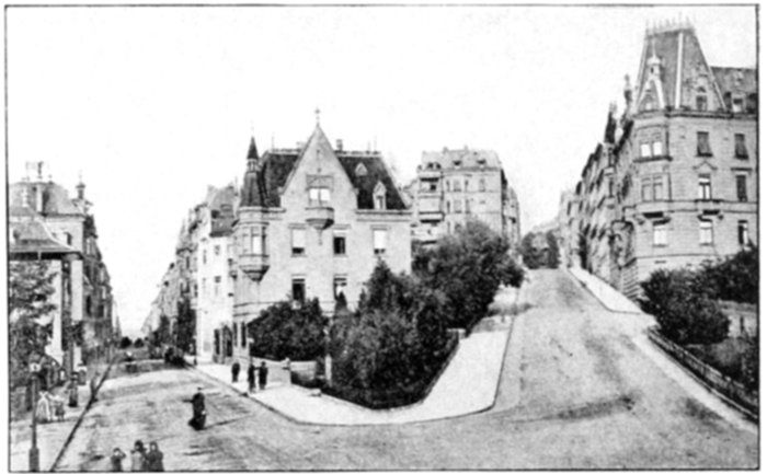
Park treatment of hillside street junction at Stuttgart
The above considerations apply only to the ordinary main thoroughfares of normal character. In most of the great cities of the world, there has been a considerable development of special thoroughfares of much greater width, including, for example, locations for transportation lines (surface or elevated), on separate rights of way decorated with trees; and including tree-shaded promenades and garden strips. These have usually been laid out in suburban sections before they were much built up; or, if within the built-up districts, on the sites of old fortifications, canals, or other abandoned engineering works. The latter opportunities are lacking at Pittsburgh, except in connection with the river banks. In the suburban localities of Pittsburgh, so much of the available building land is topographically divided into narrow strips that it would be cut to pieces in an exceptionally uneconomical manner by any boulevards, of the type usual in flatter cities, where a substantially uniform width of 150, or 200, or 300 feet is not infrequently carried through for considerable distances. As a general rule, any width to be secured for esthetic purposes in connection with Pittsburgh suburban thoroughfares, over and above that needed for handling the expectable future street traffic, must not be in the form of a general and continuous widening. But occasional pieces here and there may be taken for park purposes, as, for instance, a steep sidehill adjacent to the line and unavailable or difficult for building. Or a narrow ridge, on which the thoroughfare runs, may have at some point so little available building land fronting upon it that the whole can reasonably be parked for a short distance, thus keeping open the distant views.
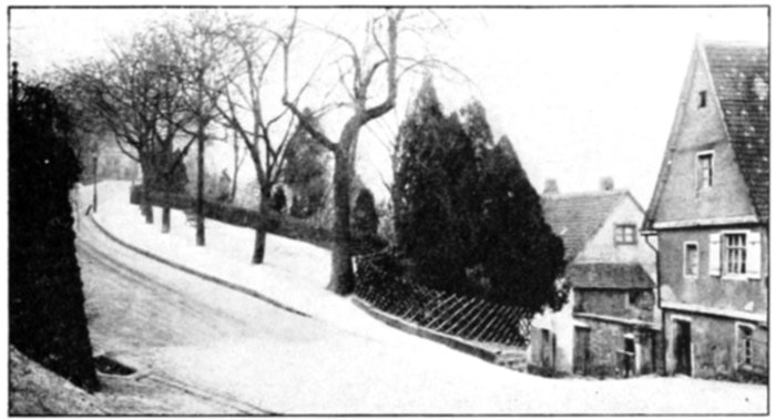
Public resting place and outlook spot on a one-sided hillside street in Heidelberg
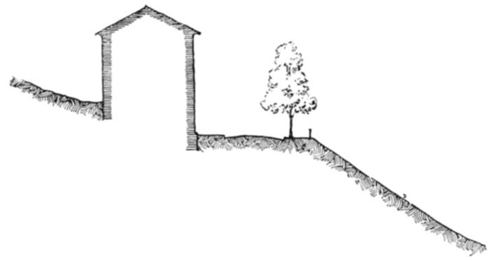
Section showing one type of hillside street
There are two special forms of street, developed here and there in hilly cities all over the world, of which Pittsburgh needs to take account in its suburban development. In many instances, and for long distances, existing suburban thoroughfares that must be enlarged and improved, and others that must be laid out, are compelled to run along the face of hills so steep that a street of level cross section, even though limited to 80 feet, would leave the land on one or both sides so far above or below the grade as to destroy its value for building purposes. In such cases it is often practicable to make use of one-sided streets or two-level streets. The former are designed to give accessible frontage on one side only, usually the uphill side. The property on the opposite side is reached by the next street, which is laid out correspondingly nearer in order not to make the lots too deep. The width of such a one-sided street may be curtailed without reducing its thoroughfare capacity because it is freed from local business all along one side. Bluff Street, though not a thoroughfare, is an excellent Pittsburgh example of the one-sided street, and illustrates the great attractiveness which such streets often possess. In a two-level street a longitudinal bank, or retaining wall, is introduced in the middle so as to adapt it to the topography and bring each half of it nearer to the natural surface where the abutting property fronts upon it. Such a street must normally be wider than a single thoroughfare of the same capacity, the saving in construction and in the development of abutting land more than counterbalancing the cost of extra width.
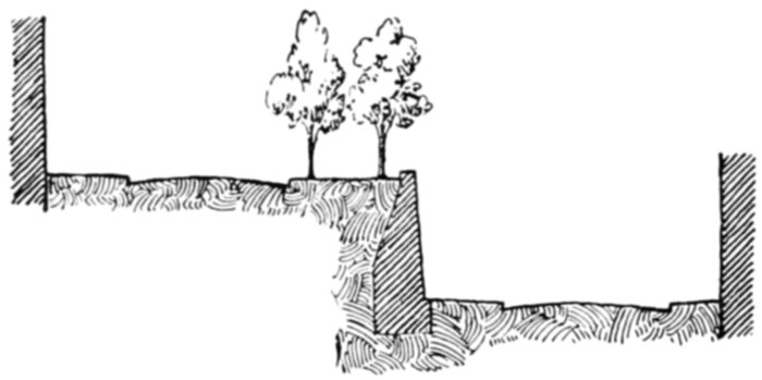
Section of a two-level street at Zurich, Switzerland.
Widths for outlying thoroughfares in a district like Pittsburgh, therefore, cannot be determined by any general rule. Each must be laid out as a problem by itself, the principal objects in each problem being to select a tolerably direct line on reasonable gradient, and so to fix the side lines of the location that it shall be possible to meet the immediate needs by constructing an economical suburban road, where it does not already exist, and ultimately to convert it into an ample urban thoroughfare with the minimum of cost and inconvenience.
Widening Old Streets
Whatever radical changes may be made to improve the present or safeguard the future condition of the thoroughfare system in regions that are now rural, there remains a huge problem within the district where the street system has already crystallized into substantially its final form. Here increased capacity can, for the most part, be secured only by local improvements and widenings of existing thoroughfares.
Fortunately, the building up of the street frontage with solid blocks of stores, apartments, and business structures, has at most points followed rather slowly after the earlier wave of detached dwelling houses, and a large proportion of the streets which are destined to be the main arteries of the huge future city are still lined by buildings which are set back at various distances from the street, leaving front dooryards between them and the sidewalk. Outside of the down town district, and a limited area in East Liberty, it is possible, therefore, to provide for the ultimate widening of these streets without the destruction of many valuable structures, provided the preliminary steps are promptly taken.
As traffic increases and the lots come to be used for business purposes, such a set-back becomes inconvenient and undesirable, and one by one the buildings are either extended to the sidewalk by new additions, or new buildings are erected on the sidewalk line. The reason for this change is not usually that additional lot depth is required, for often considerable yards are left unoccupied at the rear, but is simply that on a commercial street the buildings need to be as close to the stream of traffic as possible; and since the individual lot owner cannot move the street as a whole up to his building, he has to extend or move his building to the street. His immediate purpose is thus served, and ultimately the whole row of buildings is similarly advanced in response to changed conditions. But at just about the time when this process is fully completed, the volume of traffic flowing over the street is apt to have become so great that everybody recognizes the street to be too narrow for the increased traffic it has now to carry. If the case is a bad one, the inconvenience due to overcrowding the traveled way will in time reach a point where, in spite of the great cost of such an operation, the buildings all along one or both sides of the street have to be destroyed and a new building line established—it may be on the very line where most of the original buildings stood before increasing traffic began to offer inducements to move them forward to the sidewalk. Indeed, it may be said as a general rule that on any street where the buildings are set back from the sidewalk line the very advancement of a few buildings to the sidewalk line is a sign which points directly to the growth of travel and indicates that ample width will soon be needed in that thoroughfare.
As soon as these conditions appear, it is time to act. As already noted, it is not, in most cases, the desire to utilize a greater depth of lot which leads to the change, but the desire to get next to the sidewalk and to do away with a front yard which has served its purpose and is not wanted under the new conditions. If the street is one likely to have a considerable amount of through travel, it would be reasonable at once to lay it out wide enough to handle such travel; and the cost of the land taken for the widening would be charged, at least in part, to the abutters, for they get, by the change, what many of them already want and what the rest will soon be wanting—direct frontage on a busy sidewalk.
A still wiser course of procedure would be to determine on the widening of these future main thoroughfares before any buildings have been advanced to the sidewalk line, and to establish building lines far enough apart to leave room for all probable future requirements; but to make no physical widening of the street until the growth of travel—or the demands of the abutters—call for shifting the sidewalks over to the established building line and enlarging the roadway to correspond. This is the invariable practice in Washington and in most well-conducted European cities. It is the plan to some extent in New York, where just recently the sidewalks of Fifth Avenue have been moved back against the building line on the space formerly occupied by stoops, areaways, and dooryards. Pennsylvania Avenue and Sixteenth Street, in Washington, are both laid out 160 feet wide from building line to building line, although Pennsylvania Avenue is an important business artery and Sixteenth Street is a residence street without heavy traffic and with no commercial business. On the former, the wide sidewalks are in immediate contact with the fronts of the buildings, as is proper for a business street, and the roadway, with car tracks in the middle, is more than wide enough to carry all traffic that can ever be concentrated upon it. Whereas, on Sixteenth Street, the traveled portion of the street, including sidewalks and the space for sidewalk trees, is only 80 feet wide; and the remainder is occupied by front dooryards 40 feet deep, which the householders are at liberty to fence and use almost as freely as if they owned them in fee simple. At the same time all the householders are protected against the premature action of any individual lot owner who might see a possible advantage in being among the first to bid for a commercial business by building a flat-house with stores under it out upon the sidewalk line 40 feet in advance of the other houses. This is the sort of thing that is happening every now and then in Pittsburgh on streets where the great majority of the owners would prefer to have the set-back continued for some years longer. In Washington this crowding forward cannot be done; but when a reasonably large proportion of the owners on any street, or any block of a street, are ready for the change, the front yards are abolished and the sidewalk is moved over into contact with the buildings. If a single owner wants to put in a store long before his neighbors are ready to give up their front yards and long before the City is ready to widen the street to increase its traffic capacity, he is of course at liberty to do so; but he must not move forward of the general building line. What he usually does is to abolish his own front dooryard and substitute an extra wide piece of sidewalk paving in place of it, sometimes using the space for outdoor stands, or show cases, to attract trade. He may even be permitted to erect light temporary structures, such as awnings, on the space between his main building and the present sidewalk line, under which, in good weather, he can do a very good business.
There is, then, one course of action which overshadows, in permanent importance and in urgency, all other things that Pittsburgh could do at the present time for the improvement of its main thoroughfare system. That is to establish new building lines, at a suitable distance apart, along all of its present and prospective main thoroughfares which there is any prospect of being able to widen.
Pittsburgh, in common with other cities in Pennsylvania, has a remarkable power, which is of the utmost importance in connection with the intelligent control of its street development, but of which it has not hitherto taken adequate advantage; a power that appears to be denied to the cities of every other state in the Union, although effectively used in some other countries. Pittsburgh may legally lay out a street in anticipation of a future need, and yet postpone entering upon the land for construction or for opening it to the public. Until the city legally enters on the street, the owner of the land has the free use thereof, and he receives payment only when the opening takes place; but if, in the interim, he shall have erected any structure within the limits of the proposed street, he will receive no compensation therefor when the street is opened. Although similar laws have been declared unconstitutional in other states, this provision has been sustained in Pennsylvania, and the power has been effectively exercised in numberless cases since the middle of the last century.
Philadelphia has applied the same principle to street widenings, as for example in the case of Chestnut Street. The procedure is to define a building line, set back a certain distance from the street line, and to permit no new buildings to be erected in front of that line, but to pay damages only when the power to prevent the erection of a new building is actually exercised.
The Chestnut Street widening was authorized by legislation which provided merely that the street should be widened ten feet, without specifying the procedure or method of awarding damages.[7]
The procedure used in the widening, as above described, had apparently no other authority than the general acts under which Pittsburgh has proceeded in laying out new streets.[8] This application of those acts has been sustained by the courts. If it is held that a specific extension of the principle of the Act of 1871 to the widening of Chestnut Street was implied in the ordinance of 1874, under authority of the Act of April, 1870, and that it is not generally applicable to widenings, a general act so intending ought to be secured from the legislature.
In the Chestnut Street case existing buildings covered most of the space between the building line and the street line, and the exercise of the power, with the consequent accruement of damages, occurred in each case only when the original building was torn down by the owner and he was required to set the new building back to the new building line.
The same principle is equally applicable to those cases where the existing buildings are mostly or wholly back of the new building line; the damages becoming due in such a case only when a building permit for the erection of a new structure encroaching on the designated open space is actually withheld.
The advantages of such a method of procedure, in the case of those highways where all, or nearly all, of the buildings are now set back from the street and where a widening will ultimately be needed, are obvious and very great. In a large percentage of cases, where the street is still mainly residential, the majority of the abutters would welcome the establishment of a building line for their own protection from inconsiderate neighbors; just as the majority of people will pay higher prices for lots in a neighborhood that is protected by properly drawn restrictions for setbacks, etc., imposed by a land company. In a great many such cases abutters could be induced to waive any claims for damages on condition that the building line should be applied to the whole street. Furthermore, the actual net damages to be paid would be distributed over a long period, and a considerable proportion of them, in many cases, could properly be assessed on adjacent benefited property owners.
When the actual physical widening of the street takes place, through absorbing the restricted zones on each side of it, the damages for land taking will be comparatively small, because at that time most of the abutters will want nothing so much as that very widening, if only to bring the sidewalks in contact with the fronts of their buildings. But regardless of its clear financial advantages to the City, in reducing its total payments for street widening and especially in distributing the burden of that cost over a long period without running up a large bonded indebtedness and interest charges, the fundamental argument for this method of procedure is that it avoids the absolute dead loss to the whole community resulting from the destruction of valuable buildings. It is not practicable to avoid this in any other way and still accomplish the result of widened thoroughfares. Theoretically, it could be done by a direct widening of all the highways in the ordinary manner, if it were to be done promptly; but there are comparatively few cases in which there would be enough immediate advantage in the increased width to make the proposition attractive; and it is obvious that any such wholesale immediate action would involve a sudden and enormous financial burden which it is utterly impracticable for the City to assume.
If, after the gradual piecemeal process of widening at moderate and distributed expense has been begun, the City thinks it would prefer to have the process over and done with promptly, it is just as able to complete the widening immediately, by wholesale condemnation, as if the gradual process had never been entered upon. If the City begins on the gradual process, it can always change to the other when it feels rich enough, or when the buildings on the old lines have become few enough; and in the meantime the erection of new and costly buildings, obstructive to the proposed widening, has been prevented at comparatively slight expense. If the City does nothing, pending such time as it can afford to make the widening at a single operation, the cost of the operation is liable to mount at least as fast as the City's ability to pay for it.
While the method proposed is peculiarly adapted to handling the problem of a thoroughfare along which the majority of the frontage is not yet occupied by buildings standing on the street line, it may be objected that it is not suitable for widening one that is built up, like Forbes Street. It is true that the patchwork appearance of such a street during the process of gradual reconstruction is somewhat unsightly,—with here and there a wide place where new buildings have gone up, and between them narrow parts, thus exposing the blank side walls of old buildings projecting beyond the new ones. Yet in cities where the sense of civic beauty is far more acute than it generally is in America, this temporarily ragged condition is accepted as a small price to pay for the economical and certain accomplishment of a great permanent improvement.
Unified Procedure For City, County and Borough
It is obvious that the flow of traffic moves regardless of the artificial boundaries of the city and the surrounding boroughs, and that if an efficient system of thoroughfares is to be involved for the Pittsburgh Industrial District it will be necessary to disregard those boundaries in planning it. This has been done in the preliminary studies which have resulted in this report, and the necessity for it must control the form of any permanent organization for preparing final plans and executing them. If these duties are to be entrusted to officers of the City, and the city boundaries remain unchanged, those officers must have authority from the legislature to deal with territory beyond the boundaries of the city, as is the case in a limited way in Wisconsin cities.[9]
The simplest and most logical procedure, if the boundaries of the city and of the boroughs are to remain substantially unchanged, would be to establish a common agency for dealing with the general problems of city planning for all of the municipalities and the related parts of the country outside of them. The Constitution of Pennsylvania apparently prevents the formation of a special metropolitan board for the Pittsburgh Industrial District, but general authority might be obtained under which the County could establish such a board. If the difficulty should be met simply by extending the boundaries of the city, it is important that the new boundaries should include not merely those areas which are now seen to have close physical relations with the city, but a great extent of territory within which the beginnings of urban or suburban growth have started, or are likely to start, during the next generation.
Whether the duty of planning and providing for the main transportation lines is made a city affair or a county affair, those who are charged with it should be free to go as far in any given direction as the demands of the traffic lead them. They should neither be limited by arbitrary boundaries in those directions where scattering but connected urban development may reach out furthest from the center, nor compelled to extend their operations to an arbitrary boundary in those directions where such development falls short.
SPECIFIC RECOMMENDATIONS MAIN ARTERIES
Penn Avenue Artery
As noted earlier in this report, one of the two main eastward thoroughfare routes, from the Point District, must lie along the flat land between the Allegheny River and the bluff southeast of the Pennsylvania tracks. Through this bottle-neck must pass the trunk line (or lines) of one of the largest thoroughfare systems leading from the down town district of Pittsburgh. At the foot of the Lawrenceville hill the system branches into two main lines of extension. On the one hand are Penn and Liberty Avenues, extending, by different routes, through the Garfield, Bloomfield, Friendship and Shadyside Districts to East Liberty; and from there connecting directly to Squirrel Hill, Highland Park, Homewood, Brushton, Wilkinsburg and all points further east. On the other hand is Butler Street, following the low land along the river through Lawrenceville to Morningside and Highland Park. Via the Forty-third Street bridge, this line reaches Millvale and the country north thereof; via the Sharpsburg and Aspinwall bridges it reaches Etna, Sharpsburg, Aspinwall, and Shaler and O'Hara townships, and connects directly with the Freeport Road, the only thoroughfare leading up the Allegheny River. The trunk line of this system is composed of two narrow streets, Penn Avenue and Liberty Avenue, the one 60 and the other 50 feet in width. Even now this accommodation is inadequate, and, considering the extent of territory served and the increase of through traffic to be expected as the city grows and the outlying lands develop, a much greater capacity for general traffic through this throat will very soon be needed.
There are four different ways in which this greater capacity might be realized.
In the first place, a new street might be cut through north of Penn Avenue. Smallman Street, from Twenty-first to Thirty-sixth Street, already forms a good sized piece of such a thoroughfare. Pike Street would be its normal extension in town to Eleventh Street, but, like Try Street near Second Avenue, it has been surrendered to the Pennsylvania Railroad for a connecting line and spur tracks. Furthermore, it is very narrow (not over 40 feet) and is difficult to widen on account of the many industrial plants abutting thereon. The connections from such a thoroughfare with Penn Avenue, Liberty Avenue and Butler Street at one end, and with the down town thoroughfares at the other, are quite indirect; and they could be improved only at great expense.
The only other place for a new thoroughfare is along Spring Alley, between Penn and Liberty Avenues. As this whole block is only 220 feet wide, including the alley, it is obvious that a broad avenue through the middle of it would leave the abutting property in very uneconomical shape.
As a modification of this plan, the widening of Spring Alley entirely on the south side was considered. As this would leave lots 40 feet or less in depth between the new street and Liberty Avenue, it would mean the practical destruction of the half-block from Spring Alley to Liberty Avenue. The remaining strip could be taken as a central parking space in a wide boulevard thoroughfare, extending from Spring Alley to the railroad; or Liberty Avenue could be abandoned, and the space, left between the new street and the railroad, could be used for warehouses or for business wanting direct railroad connections; or it might be sold in whole or in part to the Pennsylvania Railroad, for additional track space. It is obvious that each of these plans cuts up the property undesirably: the first is not only costly but is extravagantly wasteful of land in a region where available land is strictly limited and should therefore be put to its most efficient use: and the other plans both involve an entire redistribution of the land south of the new street. They could hardly be executed without powers of "excess condemnation" for which constitutional authority is lacking.
A third plan would be to widen Liberty Avenue on the north side. There is no special difficulty in the way of this scheme, and it could certainly be more easily carried out, and at less cost, than any of the Spring Alley plans. Merely as a traffic way between two points, Liberty Avenue widened would be perfectly satisfactory, but several incidental considerations must be borne in mind. First, the lots on the north side of the street would be cut at least to 70 and probably to 50 feet, neither of which is a desirable depth for lots on a main thoroughfare; and second, the street would have business frontage on one side only. The latter is an uneconomic arrangement from the point of view both of the real estate owner and of the City, and the street would be much less agreeable than if it were separated from the railroad.
The fourth plan would be to widen Penn Avenue. This street is now 60 feet in width, and most of the lots on each side are 100 feet deep, except for several blocks on the north side where they are about 120 feet. The street is built up solidly on both sides, but scarcely any of the buildings are new or costly. The property values are almost uniformly a little higher than on Liberty Avenue. If Penn Avenue were widened 10 feet on each side, making an 80-foot thoroughfare, the abutting lots would still be 90 feet or over in depth; and if the street were made 100 feet wide, the lots would still be 80 feet deep. Though it might cost somewhat more to widen Penn Avenue than Liberty Avenue, it is evident that the abutting property would be left in far better shape, and the benefit to be had from increased frontage value would be much greater.
After due consideration of each of the above plans, bearing in mind the cost, the difficulty of carrying it out, and the value of the result, both as an important main thoroughfare artery and as a local improvement, it is recommended that Penn Avenue be widened to 100 feet. If the widening is to be accomplished by the gradual process,[10] that is by merely establishing the new building lines at the present time, and by paying damages only when new buildings are set back to this line, the widening should probably be made on both sides: for in this way the minimum set-back will be required for individual new developments and the lots will be left of a good depth on both sides of the street. But if the widening is all to be made at once, it will be less costly to make it entirely on the south side. In either case, the lots remaining will be none too deep, and it is suggested that ultimately Spring Alley may be abandoned and the opportunity furnished for deep lots for warehouses and similar purposes, fronting on a large thoroughfare and having direct railroad connections over Liberty Avenue in the rear.
Forbes Street Artery
The other eastward thoroughfare system lies south of the Hill District. From Soho eastward there are two main branches to the system: on the one hand are Forbes Street and Fifth Avenue, leading through Oakland to Bellefield, Shadyside, East Liberty, Squirrel Hill, and all points east; on the other hand is a possible and much-needed thoroughfare reaching Greenfield, Hazelwood, Glenwood, and Hays, and from there, by branches and extensions, connecting to Homestead, Duquesne, McKeesport, and points up the Monongahela and Youghiogheny Rivers, as well as to the country south in Baldwin, Mifflin, Snowden, and Jefferson townships.
At present the trunk-line of this system (from the Point District past Soho hill) is composed of three narrow streets, Second Avenue, Forbes Street, and Fifth Avenue, which all together are no more than adequate to accommodate the present surface travel. Future developments in the East End, up the Monongahela, and in the country south of Homestead, and improved thoroughfare connections with the two latter regions, will undoubtedly increase the through traffic on these streets to such an extent that their capacity will soon be taxed beyond its limit. There can be no doubt that more accommodations will be needed in the near future.
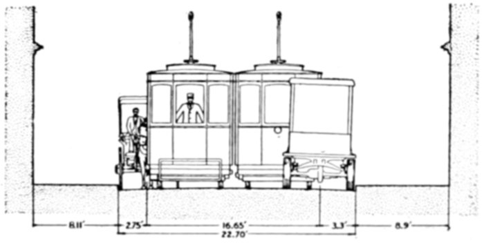
Section of Second Avenue between Try Street and Tenth Street Bridge
At first thought it was hoped that Second Avenue might be improved to accommodate a reasonable increase in east and west traffic; but the Baltimore & Ohio Railroad on one side, and several large industrial plants on the other, present serious obstacles to widening it. A plan to exchange locations with the railroad was considered, but it did not appear to offer sufficient advantage to the railroad to tempt them to cooperate in the matter.
Incidentally, Second Avenue can and should be widened to 80 feet, from Ross Street to the Tenth Street bridge, thus making a good connection between the Point District and the South Side.
It remained then to secure the desired street capacity, in some way, through the valley now occupied by Forbes Street and Fifth Avenue. To avoid the higher land values on these streets, various schemes were tried to get a third thoroughfare in this valley, first on the south and then on the north side, but without success. The indirectness of line and the seriousness of grade difficulties, coupled with cost of cutting new connections at either end, more than outweighed the advantages offered by the cheaper land.
One proposition, however, is worthy of special remark. That was to cut a new street from Fifth Avenue, near Sixth Avenue, to the end of Colwell Street, widen the latter, carry it over the Moultrie Street valley on a high viaduct, skirt around Soho hill, partly above and partly below Beelen Street, and either join Fifth Avenue at Robinson Street, or, going over this street, follow along the hillside and meet the southerly end of Bayard Street. The cost of constructing this line, the complication of grades with cross-streets (owing to the width of the new street), and the difficulty of getting good connections with any thoroughfares leading up the Monongahela, practically put it out of the question as a solution of the main problem in hand. But it offers many advantages as a specialized thoroughfare for fast-moving automobiles for the East End. It is well up on the hill, furnishing, at times, fine outlooks over the river; the gradient need nowhere be over 4 per cent, and the line could be easily laid out so as to have very few grade crossings with other important streets. It is urged that this route be borne in mind when the demand is felt for another "Grant Boulevard," south of the Hill.
It remained, then, to consider adequate widenings of Fifth Avenue or Forbes Street. The former is now 60 feet wide throughout; it is by far the more important thoroughfare at present, land values are much higher than on Forbes Street, and new and somewhat costly buildings are already crowding out the cheap houses of an older generation. Forbes Street is also 60 feet in width, except near its westerly end where it is only 50 feet, but the buildings, on the whole, are much less valuable than those on Fifth Avenue. Lot depths are practically the same, and so are the street gradients. It is evident, therefore, that the widening of Forbes Street should be a far less costly undertaking than the widening of Fifth Avenue.
A thorough study of the possible eastward extensions of Forbes Street has developed no obstacles to using it as the principal thoroughfare. By referring to "Outlying Thoroughfare Improvements" below (Sections 11, 14, 15, 16, 17 and 19), it will be seen that a cross connection can easily be secured at Brady Street to Fifth Avenue—the latter being the easier street to widen beyond this point, as well as offering somewhat better gradients. It will also be seen that the thoroughfare extension to Greenfield, Hazelwood, Glenwood, and eastward, can branch from Forbes Street (just east of Brady) more easily and cheaply than it could from Fifth Avenue. Forbes Street, moreover, enters the down town district at a slightly more central, and, considering the proposed improvements in the down town district, a more advantageous point.
It is recommended, therefore, that Forbes Street be made the main artery of this eastbound thoroughfare system, and that it be widened to 100 feet. As in the case of Penn Avenue, the widening should be made on both sides if done by the gradual process; but if done all at one time, it should be made entirely on the south side.
South Hills Artery
Between the Point District and the South Hills there is now urgent need for a thoroughfare connection of adequate capacity and on reasonable gradients. At present the only access for surface traffic—except electric cars—is via the Brownsville Road, or South Eighteenth Street, or the inclines. The two roads are steep, from 7 to 8 per cent, and the inclines are expensive and of very limited capacity. The South Hills country is sparsely developed as yet, but, being comparatively free from smoke and very near to the business district, it offers unusually desirable opportunities for homes, and it must soon be thickly settled. The need for a good thoroughfare to this region will then be of far greater importance even than now.
Only two reasonable ways of securing such a thoroughfare appear. One is by a new slanting road up the hillside south of the river, much longer, and so on an easier gradient, than Brownsville Road; the other is by some high-level bridge and tunnel scheme, such as that proposed by residents of the South Hills.
The opportunities for a hillside road have been studied with some care, but the excessive length required to get a reasonable gradient, and the difficulties and high cost of constructing a wide thoroughfare on the steep hillside, have proved to be serious drawbacks to all possible plans for such a street.
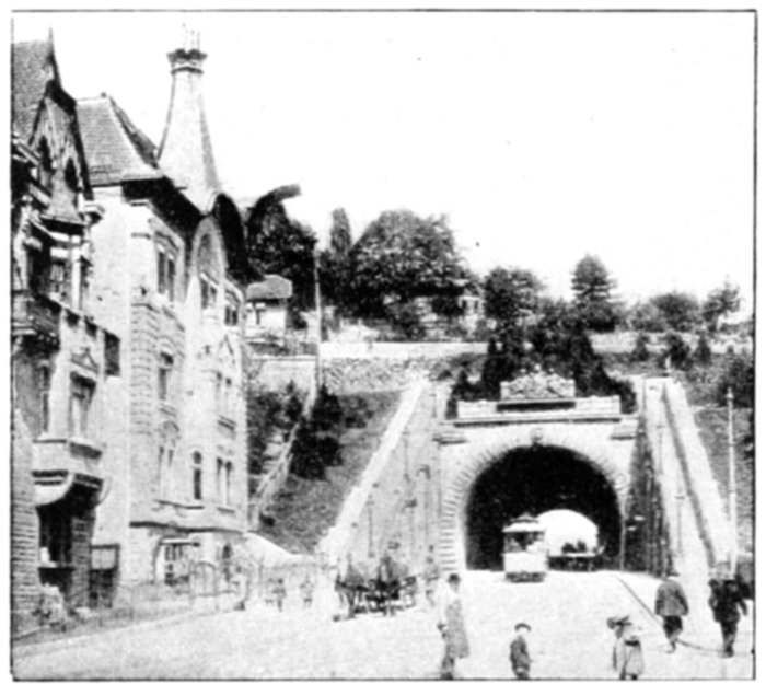
Entrance to a thoroughfare tunnel, Stuttgart
In any thoroughfare scheme to the South Hills, it is reasonably clear that the end to be attained is the most direct access possible on easy gradients to the higher levels of the South Hills country. For it is on the upper levels, the hilltops and the upper slopes, that most of the present development has taken place; and there can be little doubt that in the future, even when building space is at a much higher premium than it is now, the overwhelming majority of the population will be found on the hills rather than in the narrow valleys.
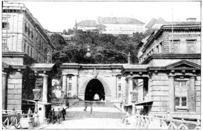
Thoroughfare tunnel at Budapest
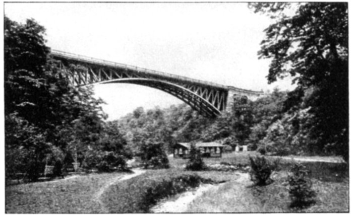
Panther Hollow bridge—a good-looking viaduct in Pittsburgh
There are certain general tendencies which are observable, both in America and in Europe, in cities which have a large area of hilltop land separated by deep valleys. The hills are generally preferred for residential purposes, and the earliest roads or trails often follow the ridges, plunging down and climbing up again steeply to get from one ridge to another. The main roads in the second stage of development are apt to seek the valleys for the sake of good gradients, with a corresponding development of the most active urban growth in the valleys and on the lower slopes; the hilltop development being retarded by lack of transportation facilities. Nevertheless the continued attractiveness of the uplands slowly builds them up, and as the wealth of the community grows there is an inevitable tendency to reduce the obstacles to ready connection between one hill district and another by raising the levels of the bridges which cross the intervening valleys. Bolder and bolder viaducts are built, until finally there is a complete and more or less independent highway system on the upper levels, and the major part of the residential district comes to be there too.
Obviously, therefore, every opportunity should be utilized to gain grade, in the approach to the South Hills District, by starting at a high elevation and wasting no distance in level stretches, if the most efficient thoroughfare artery to this district is to be secured.
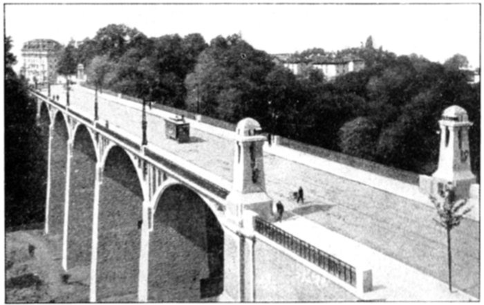
A viaduct in Lausanne, showing how the valleys are spanned by the main traffic ways
The bridge and tunnel plan, proposed by residents of the South Hills, is briefly as follows: to start from Forbes Street, at Sixth Avenue, and rise steadily to the bluff north of Second Avenue; from here to rise on a bridge over the river, at a uniform gradient, to the opposite hill; to pierce the hill by a tunnel, at the same gradient, and reach the level of the present highways at the junction of Washington Avenue and Haberman Street. It is proposed also to have a lower deck on the bridge, which would connect East Carson Street with Second Avenue and an extension of Sixth Avenue.
This plan has the obvious advantage of starting some 40 feet higher than any of the present bridge approaches in the down town district, and at a point from 500 to 1000 feet north of any other feasible point of departure. Considerable gain is thus made at the very start. A uniform, uninterrupted gradient is proposed, from Forbes Street to Washington Avenue, in order to climb the maximum amount possible with a given distance and gradient. Information furnished us through the office of Edwin K. Morse shows that the horizontal distance from Forbes Street to Washington Avenue is 6800 feet and the difference in elevation between the two points is 260 feet. It follows that a uniform gradient, from one end to the other would be 3.82 per cent; this could be reduced to 3.74 per cent by raising the grade of Forbes Street about 6 feet, a change which is to be desired in connection with the down town thoroughfare improvements and the Civic Center. At first sight this gradient seems good for Pittsburgh; but bearing in mind the distance—over a mile and a quarter—for which this gradient is maintained without a break, considerable hesitancy is felt about recommending it for the main artery of a large thoroughfare system. A gradient of 3.5 per cent should probably be considered a maximum for such a long climb on a main thoroughfare, and 3 per cent would be far better. The former gradient could be secured by dropping the southern end of the tunnel about 16 feet, the latter by dropping it about 50 feet. In either case, the southern end of the tunnel, or its approach, would be bent westward and extended a little down the valley, north of Washington Avenue, toward the mouth of the street car tunnel. The exact amount of reduction to be desired in the tunnel gradient must be finally determined in conjunction with a careful study of its southerly extensions based on complete and accurate surveys of the possible routes. There is no advantage in lengthening one portion of a thoroughfare to get a 3 per cent gradient if nothing better than 3.5 or 4 per cent can be secured on the rest of the route. The surveys made for the County Commissioners, under the direction of E. M. Bigelow, and courteously shown to representatives of the Civic Commission, unfortunately fail to furnish the needful data, as they do not extend to the upland districts which are the ultimate objective of the proposed route.
ROUGH PROFILES OF SOUTH HILLS TUNNEL AND THOROUGHFARE ROUTES
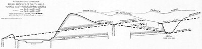
The high-level tunnel reaches existing streets at Washington Avenue. From this point is planned a system of thoroughfares, which, if constructed, would reach all parts of the South Hills. These thoroughfares are indicated by dashes beyond the junction of the tunnel with Washington Avenue.
The Bell House, or low-level tunnel is indicated by a dotted line. It is an approach to the West Liberty Road and would give easy access only to the territory reached by that road and to other territory in the nearby valley bottoms.
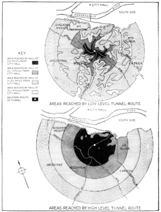
The above diagrams show the areas that can be reached via the low-level and high-level tunnel routes to the South Hills, on a maximum gradient of 3½ per cent, by hauls of various lengths from City Hall. The areas are given in the following table:
Length of haul from City Hall Total area reached Amount of land sloping over 25 per cent Remaining land available for use
Low-level route High-level route Low-level route High-level route Low-level route High-level route
2½ miles 156 acres 1091 acres 86 acres 373 acres 70 acres 718 acres
3 miles 672 " 2710 " 293 " 848 " 379 " 1862 "
3½ miles 2763 " 4877 " 1053 " 1617 " 1710 " 3260 "
4 miles 6329 " 7408 " 1935 " 2449 " 4394 " 4959 "
But even without precise data, it is clear that the best permanent means of reaching those upland districts, whether on one side of Sawmill Run or on the other, is not by a tunnel debouching in the bottom of the valley—say at the Bell Tavern. This follows from the fact that the tunnel can reach a much higher level at a good gradient and with a shorter distance. And from this higher outlet point a viaduct high in the air above the Bell Tavern would give direct access to the uplands of Beechview and Mt. Lebanon and southward, while streets of easy gradient would reach the uplands east of Sawmill Run. The high level tunnel, furthermore, will reach all the areas served by the low level, or Bell Tavern, route, and in addition can reach the other and more important lands on the hills which cannot be reached via the Bell Tavern route within a reasonable distance.
The thoroughfare extensions from the southern end of the tunnel are briefly discussed under "Outlying Thoroughfare Improvements" below. At its northern end the new bridge would fit admirably into the proposed thoroughfare system of the Down Town District, main wide streets extending directly from the end of the bridge approach to the north, south, east, and west.
Owing to the importance of the South Side as a point for the delivery of freight, a reasonably direct and easy approach from there to the new tunnel seems desirable. Freight to be teamed to the South Hills District seems likely to originate either near the Smithfield Street bridge, or east of South Seventeenth Street. From the former point, it is almost out of the question to get an approach of easy gradient to the mouth of the tunnel, on account of the lack of distance; but it must be remembered that the inclines will still be available, greatly relieved by the new tunnel from their present congestion, and further that freight for the South Hills could easily be shipped to points from which access to the new tunnel would be easy and direct. From the latter point, the connection can be secured by climbing over the railroad on a viaduct, probably along South Twelfth Street, and thence following the hillside westward on a more or less uniform gradient to the mouth of the tunnel. An examination of the hillside below the Brownsville Road indicates that such a street, though somewhat costly, is not in the least impracticable. It might be best to construct it with a minimum of cutting by the use of a sidehill viaduct of reinforced concrete.
With the modifications above suggested the plan proposed by the residents of the South Hills, for a bridge and tunnel to the South Hills District, is eminently desirable. It is, therefore, urgently recommended as the best method of securing an adequate main thoroughfare artery to this region.
OUTLYING THOROUGHFARE IMPROVEMENTS
The following recommendations are in no sense the result of an exhaustive study of the main thoroughfare system of the Pittsburgh District. They comprise only the most desirable improvements noted during a general study of the outlying branches and connections of those thoroughfares which concentrate upon the down town district. The fact that a study undertaken with such a point of view has led so far afield that it has compelled the investigation of existing and probable connections so remote as some of those noted below, is, in itself, evidence of the complexity of the highway problem, and of the fact that it cannot be dealt with locally, in a piecemeal manner, without great sacrifice of opportunity.
The improvements are designated in the following text by numbers which correspond with those on the accompanying folded map of the Pittsburgh District.[11]
1. Sixteenth Street Bridge.—The first thoroughfare branch of the Penn Avenue artery is the Sixteenth Street bridge. Because of its physical unfitness, and because it is, at present, an unreasonable interference to navigation, it must soon be rebuilt.[12]
At the time of reconstruction, the railroad grade crossing on each approach should be eliminated, probably by carrying the street over the tracks. At the southern end, the grades make such a change very simple. At the northern end, the separation of grades will be facilitated if the tracks of the Pittsburgh and Western Division of the Pennsylvania Railroad can be lowered a few feet. No physical objection to such a change of track grade is apparent.
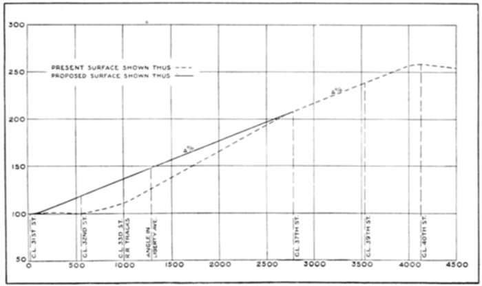
Diagram No. 1. Thirty-third Street improvement. Profile of Liberty Avenue
2. Twenty-eighth Street Grade Crossings.—Near Twenty-eighth Street the tracks of the Allegheny Valley Railroad cross both Liberty and Penn Avenues at grade. These grade crossings should be eliminated, the railroad tracks being raised to go over both streets.
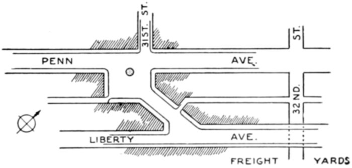
Diagram No. 2. Penn-Liberty connection at Thirty-first Street
3. Thirty-third Street Improvement.—At Thirty-third Street on Liberty Avenue there is a railroad grade crossing. The street should be lifted over the tracks and the filling extended west to Thirty-first Street and east to Thirty-seventh Street; in this way the gradient of the steep portion of the Lawrenceville hill can be reduced from 5.6 per cent to 4 per cent, which is the present gradient on the rest of the hill. (Diagram No. 1.) An easy connection should be made with the Penn Avenue artery at about Thirty-first Street. (Diagram No. 2.) With these changes the Penn-Liberty line would provide a thoroughfare from the down town district to the East End with a 4 per cent maximum gradient, which is easier than can be reasonably obtained on any other line. The northern end of the Thirty-third Street bridge and the west end of Ligonier Streets should be raised to meet the new grade of Liberty Avenue; the bridge will then be about level, and Ligonier Street will slope between 6 and 7 per cent down to Thirty-fourth Street.
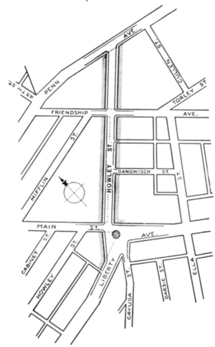
Diagram No. 3. Penn-Liberty Connection at Howley Street.
4. Sassafras Street Outlet.—Raising the grade on Liberty Avenue will seriously interfere with the western outlet of Sassafras Street. But if this street becomes of sufficient importance—and its location in the valley close to the railroads suggests a considerable development of its frontage for freight houses, warehouses or manufacturing—it will be simple and satisfactory to bring the western outlet to the junction of Penn Avenue and Butler Street by means of a short tunnel under Thirty-fourth Street from the south side of Liberty Avenue to the northwest side of Ligonier Street.
5. Penn-Liberty Connection at Howley Street.—A connection northeast from the junction of Liberty Avenue and Main Street to Penn Avenue will be needed. (Diagram No. 3). This can be secured by widening and extending Howley Street. Thereby traffic bound for the Garfield District and east thereof can climb the Lawrenceville hill by the comparatively easy gradient (4 per cent) on Liberty Avenue, avoiding the steeper hill (about 5 per cent) on Penn Avenue. This will also connect with the proposed Bloomfield bridge to Grant Boulevard.
6. Forty-third Street Bridge.—Butler Street is the main extension of the Penn Avenue artery up the Allegheny River, and its first branch thoroughfare is at Forty-third Street. The Forty-third Street bridge, like the one at Sixteenth Street, must soon be rebuilt.[13] This bridge connects Millvale and large sections of Shaler and Ross townships with the Point District via the Penn Avenue artery. The new bridge should be of ample width and should be high enough so that the approaches can be carried over the railroad tracks at either end.
7. Sharpsburg Bridge.—The Sharpsburg bridge is the next important branch of the Butler Street thoroughfare. It forms the most direct connection from Pittsburgh proper to the boroughs of Sharpsburg and Etna and to large portions of Shaler and O'Hara townships. The bridge should be widened—the present roadway being only 21 feet including car tracks—and the northern approaches should be improved. (Sections 60 and 61 following.)
8. Butler Street Improvement.—From a point nearly opposite the western end of Baker Street east to Haights Run, there is no property of value for manufacturing, or for dwellings, or stores, between Butler Street and the railroad which runs below it on the river bank. The same is true east of Haights Run as far as the Brilliant pumping station or the present beginning of Beechwood Boulevard. It seems very desirable that these portions of Butler Street, instead of being widened merely enough for traffic accommodation, be developed as a picturesque riverside parkway—a fitting approach to Highland Park and a continuation of Beechwood Boulevard. This involves the control of the narrow strip of property between Butler Street and the railroad; though occasional houses might be allowed to remain therein without detriment to the effect as a whole. The Bureau of Parks is working along these general lines, and has already bought many parcels of the land north of Highland Park between Butler Street and the railroad.
9. Haights Run Bridge.—The present Butler Street bridge over Haights Run is of light construction and has a total width of only 17 feet; this should be rebuilt of ample strength and capacity.
10. The Aspinwall Bridge.—The Aspinwall bridge, crossing the river at Six Mile Island from Butler Street to the eastern portion of Sharpsburg, is narrow (36 feet over all) and is of light construction. It is so important that it will some day need to be rebuilt of ample width and strength for main thoroughfare use. At its southern end it connects (1) with the Butler Street thoroughfare, of which it forms the northeastern extension, and (2) with a proposed cross-town line (Section 25 following) up the Haights Run Valley to East Liberty. On the north it connects directly with Guyasuta and Aspinwall, with most of the country in O'Hara township, and with the Freeport Road leading to Claremont, Montrose, Oakmont and all points up the Allegheny River. This Freeport Road is destined to become the main thoroughfare up the Allegheny because the precipitous character of the south bank of the river, and the consequent almost total absence of land suited to residential or commercial development between Highland Park and Verona, make the direct extension of Butler Street, as a riverside thoroughfare, both expensive and impracticable.
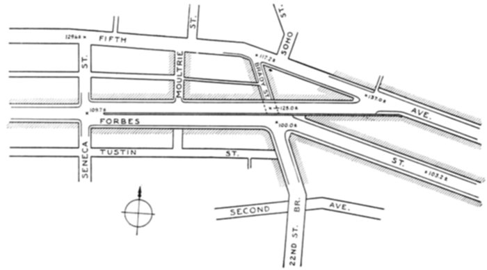
Diagram No 4. Forbes Street—Fifth Avenue connection at Soho
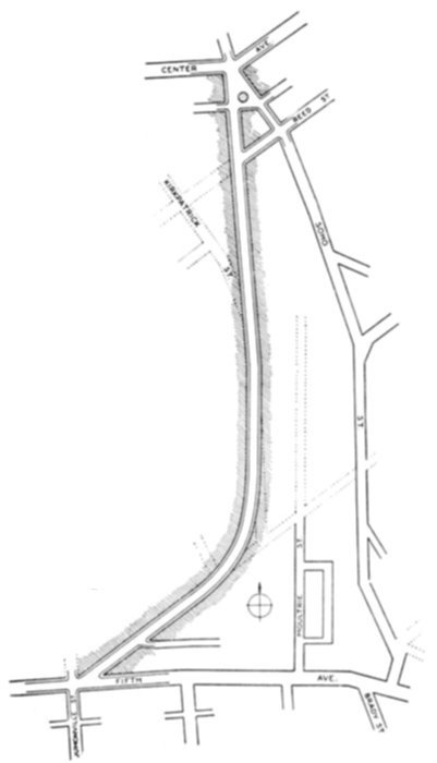
Diagram No. 5. Fifth Avenue—Center Avenue connection at Soho
11. Forbes Street—Fifth Avenue Connection at Soho.—At Soho the connection between the Forbes Street artery and Fifth Avenue—the principal thoroughfare to Bellefield and all points to the east thereof—is most simply accomplished by splitting the Forbes Street artery at Seneca Street into two levels, the upper, on the north side, running on nearly a straight line and gradient to Fifth Avenue, joining it just west of the school house. (Diagram No. 4.) The lower portion would become the continuation of Forbes Street, and should be raised at Brady Street about 17 feet, or so much that the gradient on Brady Street, up from Forbes Street under the proposed high-level street to Fifth Avenue, will not be over 6 or 7 per cent. A good gradient will still be possible on the approach from Forbes Street to the Twenty-second Street bridge; and the Forbes Street gradient, down from Seneca Street, will be much reduced. These changes will greatly improve the means of access to the Twenty-second Street bridge.
On Forbes Street, just west of Craft Avenue, there is a bad gradient for a main thoroughfare (about 6½ per cent) which is not easy to improve; but the above cross connection at Brady Street will give a through line to the East End via the Forbes Street artery and Fifth Avenue, with a maximum gradient of about 4½ per cent (on the Soho hill).
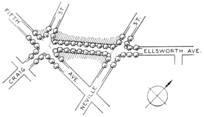
Diagram No. 6. Ellsworth Avenue extension
12. Fifth Avenue—Center Avenue Connection at Soho.—As a main thoroughfare feeding Minersville and the northern part of the Hill District, either from the South Side via the Twenty-second Street bridge, or from the Point District via Fifth Avenue or Forbes Street, a connection is needed on a reasonable gradient from Fifth Avenue to Center Avenue through the valley south of Soho hill. Such a street (Diagram No. 5) could leave Fifth Avenue at Jumonville Street, start along the location of Wyandotte Street, then curve around the nose of the hill and follow the hillside on the west of the valley; thus, by cutting away some of the recent filling at the upper end of the valley, it could reach Center Avenue at the corner of Soho Street with a uniform gradient of about 3 per cent. At present there is no way of reaching this high land on a gradient less than 7 per cent.
The new street shown on the diagram is preferred to the improvement and extension of Moultrie Street because (1) it gives a better gradient, (2) it is a more direct approach from the down town district, and (3) it leaves the bottom of the valley available for enlarging the Moultrie Street playground.[14]
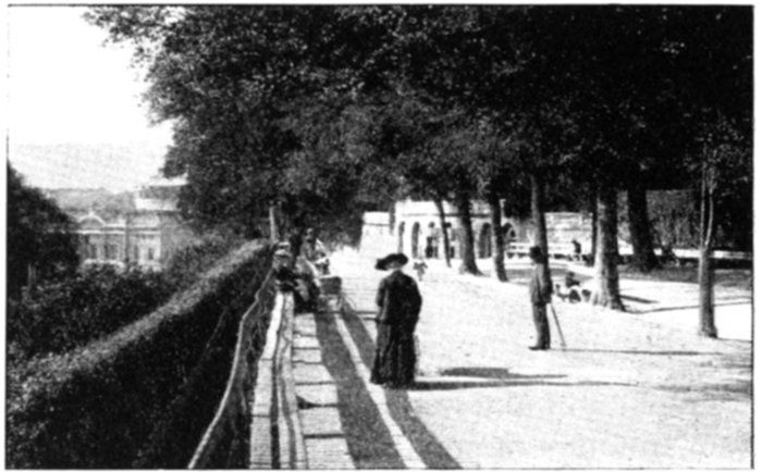
A one-sided hill-street in Geneva, possessing an incidental recreative value
13. Ellsworth Avenue Extension.—As Fifth Avenue is the principal thoroughfare to Bellefield, so Ellsworth Avenue becomes its main branch or extension from Bellefield to East Liberty. This street should not end at Neville Street, as at present, but should be extended to the corner of Craig Street and Fifth Avenue. (Diagram No. 6.)
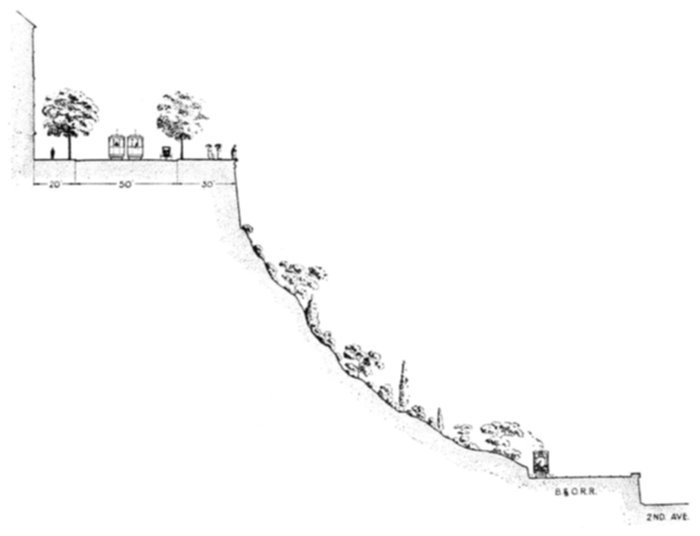
Diagram No. 7. Monongahela hillside thoroughfare—a typical section
14. Monongahela Hillside Thoroughfare.—The thoroughfare requirements from the Forbes Street artery up the Monongahela River can best be met by a hillside street, partly new and partly following existing streets, running substantially parallel to Second Avenue but along the hillside above the railroad tracks. This thoroughfare would leave Forbes Street at the bend about 1200 feet east of Brady Street, cross the little valley (which should be filled north of the new street) and extend eastward, crossing Bates Run on a viaduct, and using, where possible, parts of Lawn and Frazier Streets, to the mouth of Four Mile Run. Thence, by another viaduct, it would connect with Sylvan Avenue, on the north side of the valley, and follow this street widened to Hazelwood Avenue; by another viaduct it would cross the Flowers Avenue valley to Glenwood Avenue and follow the latter widened and partially regraded to Mansion Street. There it would bend to the northeast, cut through the plateau land to the next ravine, cross this on a viaduct and, bending southward again, descend around the nose of the hill to the Glenwood bridge. So easy a gradient can be obtained on this new street that it may reasonably be expected to carry nearly all the through traffic. With proper connections (the most important of which are described below), it will also take most of the travel to and from the residential districts lying above it to the northeast.
The location of this street, high on the hillside above the Monongahela River, presents unusual opportunities incidental to serving its primary purpose as a main thoroughfare. With an ample roadway for all kinds of traffic, with trees for shade and decoration, with a broad promenade overlooking the river and the hills to the south, it would furnish rare and much-needed facilities for recreation; and, further, it would have a distinctive character most appropriate to the rugged topography of the Pittsburgh District. (Diagram No. 7.)
15. Bates Run Connection.—Starting from the western end of this new street, the first important transverse street connection would be at Bates Run. Here a street should be run up the east side of the valley, not far from the present location of Romeo Street, to the intersection of Wilmot and Bates Streets, thus reaching the Oakland District.
16. Greenfield Avenue Connection.—On the southeast side of Four Mile Run the new thoroughfare will pass over Greenfield Avenue. But a connection should be made therewith by running a practically level street, from about the junction point of Sylvan Avenue and the new thoroughfare, northeast along the hillside adjacent to Greenfield Avenue until it meets the Greenfield Avenue grade.
17. Greenfield and Squirrel Hill Extension.—From this point on Greenfield Avenue a new street should be built running to the northeast. It would cross the first little ravine on a viaduct, thence follow the south bank of the Four Mile Run valley, climbing at a uniform gradient, and join Beechwood Boulevard at the southern end of the bridge into Schenley Park. This will furnish a direct connection from the new hillside thoroughfare to the eastern portion of the Greenfield District and to Squirrel Hill; the maximum gradient will be only about 3½ per cent instead of about 7 per cent as at present on Greenfield Avenue.
This new street could be extended, from the point where it joins the boulevard, underneath the Greenfield Avenue viaduct, along the side of the valley to the south and up to the higher portions of the Greenfield District. The gradient of such a street need not exceed 5 per cent.
18. Hazelwood Grade Crossing.—Although the construction of the hillside thoroughfare (Section 14 above) does away with the necessity for widening Second Avenue east of the Tenth Street bridge, Second Avenue is still an important main line, and all feasible improvements should be made thereon. One of these is the elimination of the grade crossing at Hazelwood, and here Second Avenue should probably be carried under the tracks.
19. Glenwood Bridge.—The Glenwood bridge becomes a most important link in the thoroughfare system; it connects Second Avenue and the proposed hillside line at one end, with Eighth Avenue in West Homestead and with the mouth of Streets Run at the other. Eighth Avenue leads up the Monongahela to Homestead, Munhall, Rankin, Braddock, Bessemer, Duquesne and McKeesport; Streets Run is the starting point of several important thoroughfare lines into the country south and east. One of these thoroughfares will undoubtedly be a main line from the city proper to Dravosburg and points above on the Monongahela River. The bridge should certainly be widened and the gradients of the approaches improved, especially that from Second Avenue.
20. Baum Street Improvement.—Grant Boulevard will always be an important line to the East End, especially for fast-moving travel. To improve its outlet eastward from Herron Hill, Baum Street and South Atlantic Avenue should be connected and extended west to Craig Street. The connection between the two streets is easily made by cutting through the corner between Liberty Avenue and Rebecca Street, leaving a small triangular park. The extension of South Atlantic Avenue will require a bridge over the Pennsylvania Railroad just east of Morewood Avenue, a bridge over the Baltimore & Ohio tracks, and the grading and paving of the street already located west to Melwood Avenue and Craig Street.[15]
At its eastern end the outlet into Penn Avenue should be improved by widening Whitfield Street on the east side and by rounding back the corner of Baum Street and South Highland Avenue.
21. Center Avenue Improvement.—The junction of Center, Ellsworth and South Highland Avenues at East Liberty is certain to become a congested point and to require more ample outlet into Penn Avenue. Several possible solutions have been considered, but the simplest plan, and probably in the end the most economical and satisfactory, is to widen Center Avenue on the south side from South Highland Avenue to Penn Avenue, cutting off the jog at the latter end. This improvement will give ample connection with Penn Avenue and the more important streets radiating from East Liberty. (Diagram No. 9.)
22. Hamilton Avenue Extension.—The proposed extension of Hamilton Avenue from Fifth Avenue west to Penn Avenue is certainly desirable. The western end, however, should not be located adjacent to the Pennsylvania Railroad tracks (as planned by the Bureau of Surveys) but should join Frankstown Avenue at Station Street. (Diagram No. 9.) This location provides a more economical arrangement of streets and lots because it avoids (1) constructing a main thoroughfare with business frontage on only one side, and (2) leaving a building block only 100 feet in total depth between two main streets. The plan necessitates widening Frankstown Avenue, but this street is an important thoroughfare much in need of widening on its own account and a few additional feet to accommodate Hamilton Avenue traffic will not materially affect the cost.
At its eastern end the Hamilton Avenue extension should connect more directly with Kelly Street. This connection can be secured by widening and constructing Kelly Street, as located, from Fifth Avenue to Julius Street, and from there building a short diagonal to Hamilton Avenue. (Diagram No. 8.)
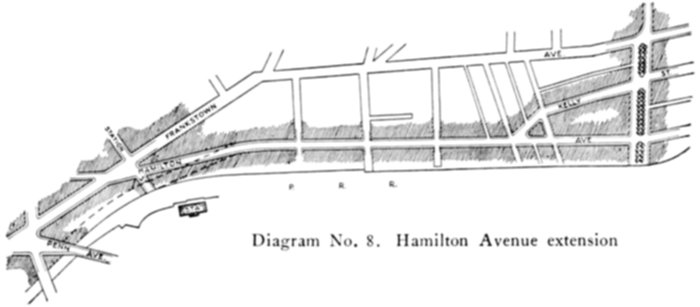
Diagram No. 8. Hamilton Avenue extension
23. Negley Run Boulevard.—East Liberty is so important a junction point of main thoroughfares, a distributing point as it were, that good connections to all localities are important. One of these is a boulevard, or street, chiefly for pleasure vehicles, down Negley Run to Beechwood Boulevard. It could practically follow the lines of Princeton Place and Butler Street. By widening and regrading these streets and by acquiring and controlling the ravine and its banks a very attractive boulevard may easily be secured. Incidentally an extremely unattractive and undesirable Negro and Italian settlement, in this valley, will be cleared out.
24. Larimer Avenue Extension.—Princeton Place, or the boulevard just proposed, and Larimer Avenue, a thoroughfare leading into the Lincoln District, both dead-end at Broad Street. A connection for both should be made through to Penn Avenue. (Diagram No. 9.)
When this change is made and Frankstown Avenue is widened (Section 22) the eastern corner of Frankstown and Penn Avenue should be cut back to aid general traffic circulation.
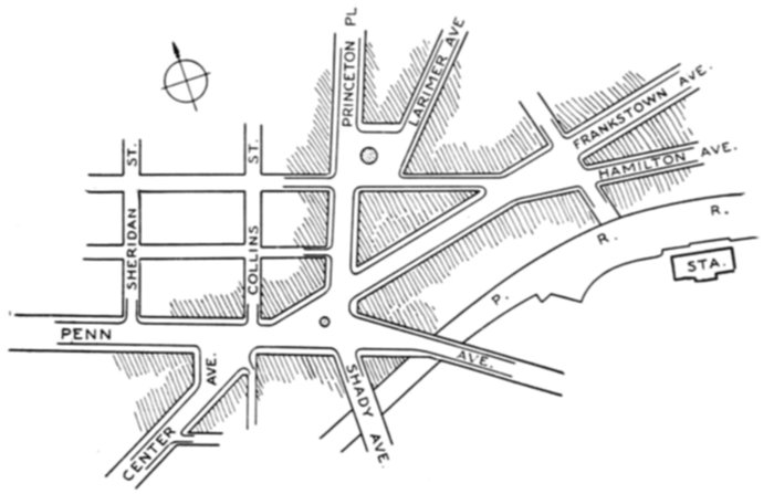
Diagram No. 9. East Liberty Improvement
25. Haights Run Thoroughfare.—Another connection to be desired is from the East Liberty center to the Aspinwall bridge. The needed link is from Stanton Avenue to Butler Street. Following Haights Avenue for two blocks the new street should extend down the west bank of the Haights Run valley, with a maximum gradient of about 3½ per cent, to Butler Street. This new street would be used for both business and pleasure traffic, and its location on the steep side of a beautiful valley, much of which is already park land, will greatly enhance its value as a pleasure drive.[16] West frontage on this street, where the bank is not too high for use, will have a peculiar value for residential purposes owing to the permanence and beauty of an unobstructed outlook toward the park.
A branch connection might easily be secured (at a somewhat steeper gradient) between this new street and the table land of the Morningside District by winding up the side of the branch valley and joining Chislett Street four or five hundred feet south of Martha Street.
26. Meadow Street Connections.—Stanton Avenue is already an important thoroughfare feeding the high sections of Morningside and cross-connecting many radial streets especially in the Highland Park District. Meadow Street is its logical extension to the southeast, and by an approach from Stanton Avenue to the new Meadow Street bridge over Negley Run these two streets can and should be connected. It is understood that this connection is already being made.
Unfortunately on the east Meadow Street comes almost to a dead-end a block or so before reaching the junction of Frankstown and Fifth Avenues. Owing to the location of the Pittsburgh Hospital, the direct extension of Meadow Street is impracticable and the outlet to Frankstown Avenue can best be secured by widening Finley Street.
27. Stanton Avenue Connection to the Lincoln District.—A viaduct should be built from Stanton Avenue, at substantially the point where it enters Highland Park, running over Beechwood Boulevard and the Brillant Cutoff tracks to that portion of Highland Park lying east of the railroad and now practically unused because of its inaccessibility.
Furthermore, if it shall be possible to acquire a considerable portion of the Highland Cemetery property (still vacant) for residential or other taxpaying use, or if simply a right-of-way can be secured through the cemetery property, a combined thoroughfare and boulevard should be built from the viaduct above proposed, running about as shown on the map and connecting with Lincoln Avenue at the top of the hill. By this line the steep gradients on Lincoln Avenue can be avoided and the high country to the east reached on a gradient of not over 4¾ per cent.
28. Beechwood Boulevard Connection.—Chiefly for pleasure traffic more street accommodation is needed between the ends of Beechwood Boulevard, at Frankstown Avenue and at Fifth Avenue. As the Pennsylvania Railroad freight yards practically prevent linking the ends of the Boulevard by a new street west of Fifth Avenue, the best plan would be to widen Fifth Avenue, from boulevard to boulevard, enough for two roadways, one for pleasure vehicles and the other for business traffic. (Diagram No. 10.) The west roadway would be best suited for pleasure travel because more than half of the west frontage is occupied by freight yards requiring access at only one or two fixed points.
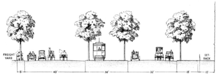
Diagram No. 10. Beechwood Boulevard connection. A possible section
29. Boundary Street Improvement.—The plan to relocate and lower the Baltimore & Ohio Railroad tracks in Junction Hollow and to construct a cross-town thoroughfare on the present railroad site, is advantageous to all concerned and, it is hoped, will soon be carried out. The new street (Boundary Street relocated), at its southern end, should connect both with Second Avenue and the proposed hillside thoroughfare (Section 14); with the former by following the present line of Forward Avenue south to Greenfield Avenue, and with the latter by going over the Baltimore & Ohio tracks just north of the present Sylvan Avenue viaduct, and extending west along the bank up to the new hillside street. At its northern end the new Boundary Street would bend to the east, after passing under Forbes Street, and, following the side of the ravine to get an easy gradient, curve westward again and join Fifth Avenue at Clyde Street. A branch to the west could connect with Boquet Street at Joncaire and with Forbes Street at the Schenley Park entrance. (See Bellefield Improvement, Plans A and B, Part IV, pages 102 to 104.)
The new Boundary Street line should further be extended from Clyde Street north to Millvale Avenue at Center Avenue. This will give a continuous cross-town thoroughfare—the first one on a good gradient east of the down town district—from Second Avenue on the south to Penn Avenue on the north, tapping, en route, practically all the radial thoroughfares in the East End.
30. Murray Avenue Extension.—Murray Avenue, in Squirrel Hill, is of secondary importance as a thoroughfare, owing to its steep gradients: but its usefulness can and should be increased by extending the street south along the line of the street railway from Forward Avenue, over Beechwood Boulevard on a viaduct or bridge, to Hazelwood Avenue.
Practically as a continuation of this line and of the Boulevard, the present roadway to Brown's bridge, now maintained by the Street Railways Company, should be widened and improved as a city street.
31. Beechwood Boulevard Re-alignment.—Beechwood Boulevard at Monitor Street makes two uncomfortably sharp bends to skirt a ravine. The ravine should be filled out two or three hundred feet from the upper end, and the Boulevard should be carried across on an easy curve at the eastern edge of the fill.
32. Second Avenue Extension.—From the Glenwood bridge to the mouth of Nine Mile Run, the old location of Second Avenue, between the Baltimore & Ohio tracks and the river, presents a first-rate opportunity for a riverside street or boulevard. There are practically no buildings or industries requiring river frontage for commercial purposes, and yet there is sufficient room for a riverside thoroughfare of ample width without encroaching too much upon the flood section of the river. In a city where rivers play so vital a part in the commercial development, and form a most telling and characteristic element in the landscape, every opportunity should be seized to enjoy as well as utilize them.
To be well above a maximum flood line, a boulevard along the water's edge would have to be nearly as high as the railroad grade; but to avoid the large cost for river walls and filling, which such a construction would imply, the road could be built at a level only rarely flooded without sacrificing an appreciable amount of its essential value for recreative purposes. At its southern end it would rise over the Baltimore & Ohio tracks, a short distance east of the Glenwood bridge, to connect with the proposed hillside thoroughfare (Section 14); and at its northern end it would rise to connect with Brown's bridge, and from there could extend into the Nine Mile Run valley. A parallel location for this street, on the hillside above the railroad, has been suggested and carefully considered; but it is believed that, owing to the large amount of retaining wall required, the cost of construction would be almost, if not fully, as great as in the other location, and, other things being equal, it is a very real disadvantage to have a railroad between the river and a road which would otherwise have so much value as a pleasure drive. In either location, however, this street would form an attractive and important link in a hoped-for park and parkway development.[17]
33. Batavia Street.—Frankstown Road is the principal thoroughfare feeding large portions of Penn township and country to the east. The importance of this line means inevitably the concentration of much traffic at the junction of Frankstown Avenue and Oakwood Street where the Frankstown Road begins. Some relief can and should be afforded by improving portions of Batavia Street and extending it to Frankstown Road at Blackadore Avenue. Batavia Street should also be extended across Oakwood Street to Kelly Street, thus encouraging the use of the latter as an approach to the Frankstown Road thoroughfare.
34. Wilkinsburg Grade Crossings.—In Wilkinsburg three important streets,—Rebecca Avenue, South Avenue and Penn Avenue,—cross the Pennsylvania Railroad tracks at grade. Although plans for separating these grades must depend on the general plan of the Railroad for improvements in this region, it seems that the best solution, both for the Railroad and for the people, will probably be to raise the tracks as much as possible and to carry them over the streets. It is supposed that a plan to raise their tracks is now under consideration by the Railroad.
35. Wilkinsburg-Edgewood Connection.—Improved thoroughfare connections from Wilkinsburg through Edgewood to Swissvale, Rankin and beyond are much needed. Pennwood and Edgewood Avenues offer perhaps the most promising route. By sufficiently widening the former from Hampton Avenue to Hutchinson Avenue it can be divided, the east half remaining as at present, and the west half rising gradually to an overhead railroad crossing at Hutchinson Avenue. East of the tracks the street would descend gradually to the south over Race Street to the junction of Swissvale and Edgewood Avenues, forming practically an extension of the latter.
Pennwood Avenue should also be extended along the railroad from Rebecca Avenue to Penn Avenue. If possible, the small freight yard now in the way should be removed, perhaps to the other side of Penn Avenue, but if this proves to be impracticable it will not be unreasonably indirect to carry Pennwood Avenue around and simply cut back the southerly corner of the freight yard.
36. Braddock Avenue—Northerly End.—Braddock Avenue should be an important thoroughfare, cross-town from Frankstown Avenue to Forbes Street, and radial from Forbes Street southeast. North of Penn Avenue it is only located; this portion should be constructed and the railroad grade crossing eliminated.
37. Braddock Avenue Viaduct.—To avoid the two, long, bad gradients on Braddock Avenue, crossing the Nine Mile Run valley, a diagonal connection should be made from Henrietta Street and Braddock Avenue to Hutchinson and Laclaire Streets. From the southern end of Laclaire Street a viaduct should be built across the valley, and connections should be made to South Braddock Avenue at the top of the hill and to Monongahela Street at Euclaire Street.
38. Rankin Improvement.—Miller Avenue and Fifth Avenue extension continue the Monongahela Street thoroughfare in Rankin. The sharp cramped corners at Harriet Street should be eliminated by cutting a diagonal from Miller Avenue at Gas Alley to Fifth Avenue extension at Harriet Street.
The steep gradients and cramped turns from Hawkins Avenue to Braddock Avenue, at the Braddock borough line, should be short-circuited by extending Fifth Avenue eastward from Hawkins Avenue to Kenmawr Avenue, lowering the grade of the latter or even running under it if necessary to get an easy gradient, and thence running southward along the side of the valley to Braddock Avenue.
The portion of Braddock Avenue north of the Pennsylvania Railroad should connect with this new street by bending sharply to the west, after crossing the tracks, descending on a gradient of 4 or 4½ per cent, and joining the Fifth Avenue extension at about Antisbury Street.
39. Forbes Street Extension.—Kelly Avenue is the best extension of Forbes Street from East End Avenue, under the Pennsylvania tracks, to the eastern portion of Wilkinsburg. The two streets do not connect easily at Peebles Street, and a diagonal should be run through the Pittsburgh Field Club grounds from East End Avenue to Kelly Avenue.
From Trenton Street to West Street, Kelly Avenue is quite steep; but the gradient can easily be reduced by filling 10 or 12 feet at West Street.
40. Woodstock Avenue Extension.—Woodstock Avenue is probably the most important thoroughfare from Swissvale to Braddock, East Pittsburgh, and points up Turtle Creek; but it connects very indirectly at Swissvale with Edgewood and Braddock Avenues, its main feeders. From Rosslyn Street it should be extended to Center Street at the end of the Washington Avenue bridge over the railroad, and from there curve around parallel to the railroad, descending gradually past the Swissvale station to Braddock Avenue. The corner of Noble and Orchid Streets could be lowered to meet the grade of the new street, and the connection with Edgewood Avenue would be via Orchid Street as at present.
41. Bell Avenue Extension.—Hawkins and Bell Avenues form the natural extension of the Woodstock Avenue thoroughfare through North Braddock. The connection between these two, however (west of Jones Avenue), is indirect and cramped. Fortunately it can easily be improved; Bell Avenue should be extended northwest along High Street (by widening the latter on the south side), thence, by a viaduct or filling, across the ravine to join Hawkins Avenue at the bend by Penn Street.
42. Ardmore Thoroughfare.—The route of the Ardmore car line offers a first-rate opportunity for a direct thoroughfare from Wilkinsburg to East Pittsburgh and thence up Turtle Creek. Such a thoroughfare is much needed, partly because it will open up for development large areas of the back country in Wilkins and Braddock townships and partly because, owing to the already dense development in Rankin, Braddock and Bessemer, efficient thoroughfare widenings between the steep hills and the river would be so expensive as to be hardly justified and very difficult of attainment. The need for extensive street widenings through these districts will be practically eliminated by a thoroughfare of easy gradient along the Ardmore route. It is understood that the County has already begun the construction of this street.
43. Wilkins Township Thoroughfares.—From Wilkinsburg, Penn Avenue is the chief thoroughfare approach to most of the hilltop country in Wilkins township, feeding it via the Greensburg Pike and another highway to the east. Its gradient is very bad. A new approach can be made to the high land on an easy gradient by branching to the north from the proposed Ardmore thoroughfare (Section 42 above) about 3,000 feet east of Franklin Avenue, crossing the mouth of the first valley and following up the side of the eastern valley to the hilltop roads.
As a further improvement, opening up this high land and connecting the important radial thoroughfares, this new street should be extended north along the hilltop to Frankstown Road.
44. Greensburg Pike.—From the northwest the Greensburg Pike (or Penn Avenue) descends into Turtle Creek with many sharp angles and a very steep gradient. A new hillside street descending the west side of the hill, rounding the nose thereof, and thence extending northward down to the valley level at Turtle Creek, is not an impossible solution of the present difficulties.
45. Greensburg Pike South of Turtle Creek.—South of Turtle Creek the Greensburg Pike again ascends the hill on a pretty steep gradient. In part at least this gradient can be improved by making the route somewhat more circuitous.
46. Streets Run.—From the Glenwood bridge one thoroughfare, destined to be of importance, follows the valley of Streets Run to Miller's Grove, branching there into lines feeding Snowden, Jefferson and the southern portions of Baldwin and Mifflin townships. The street needs, in addition to widening, some re-alignment and regrading. At several points where it crosses the Run, the fords should be replaced by bridges.
47. Dravosburg and Mifflin Township Thoroughfares.—Going south from the Glenwood bridge the first valley branching eastward from Streets Run leads to the high land at Lincoln Place. Irwin Street is the present thoroughfare in this valley, but towards its upper end it becomes rather steep for main thoroughfare purposes. The most feasible plan to reach the southern highlands of Mifflin township and to connect with Dravosburg and thence up the Monongahela, is probably to follow up the south fork of the Irwin Street valley, climbing gradually but steadily along the hillside, and reaching the high land above the head of Thompson Run. From this point branch roads can tap much of the hilltop land of the township. Extending southeast the main road would cross the ridge south of Thompson Run, and descend gradually along the south side of the ridge to Dravosburg; there it would connect with lines up the Monongahela River.
The high land between Streets Run and Whitaker Run can probably be best served by a hillside road following up the valley between Homestead and West Homestead.
48. Eighth Avenue Improvement.—The Eighth Avenue extension, from Munhall to Duquesne, has for the most part a satisfactory gradient for a main thoroughfare; but just south of Green Spring it is unnecessarily steep. The road can easily be shifted a little down the hill, and the climb lengthened enough to get a very easy gradient.
The location of this thoroughfare high on a precipitous hillside overlooking the river and the enormous industrial plants at Braddock and Bessemer, vital elements in the development of the Pittsburgh District, presents an opportunity for scenic value which should not be overlooked. The natural beauty of the hillside and the interesting outlook over the river should be preserved.
49. Eighth Avenue Branch Westward.—The best way to reach the high land west and northwest of Duquesne is from the Eighth Avenue thoroughfare. A branch could easily wind up the hill from the vicinity of Kennywood Park, and thence cross the hilltops forming a main east and west thoroughfare.
50. Eighth Avenue Branch to Dravosburg.—From the next plateau south of Kennywood Park a branch could be extended southwest across Thompson Run (on a viaduct) and along the high land south of the Run. By branches, very little steeper than the main road, good connections can be secured with Duquesne and Dravosburg.
51. Duquesne Bridge.—The bridge from Duquesne to McKeesport has cramped and dangerous approaches at both ends. The northern approach should be widened and made less abrupt. The southern end of the bridge should be lifted and the bridge extended over all the railroad tracks.
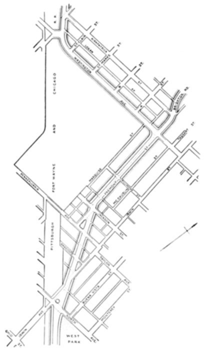
Diagram No. 11. Connection from West Park, north side to California Avenue and Brighton Road.
52. California Avenue and Brighton Road Extension.—Coming now to the North Side, one of the most important thoroughfare routes runs northwest through Bellevue, Avalon, Ben Avon, Emsworth and down the Ohio River to Sewickley, Leetsdale and points beyond. California Avenue in Allegheny, Lincoln Avenue in Bellevue, California Avenue again in Avalon, then either Brighton Road in Ben Avone, and the old Beaver Road in Emsworth, or the route followed by the street-car line through these two boroughs, and the Beaver Road again beyond, practically comprise this thoroughfare.
Connecting with Stockton and Marion Avenues, a street should be cut through West Park, North Side, adjacent to the east side of the railroad from Ohio Street, to the junction of Irwin and North Avenues. Thence a diagonal should be cut through to the corner of Pennsylvania Avenue and Fremont Street. (Diagram No. 11.) These changes, together with the widening of Fremont Street and Washington Avenue, will give a proper and sufficient outlet (and inlet) for both the California Avenue and the Brighton Road thoroughfares.
California Avenue should also be cut through, adjacent to the railroad, from the corner of Sedgwick and Kirkpatrick Streets to Wolf Alley.
53. Brighton Road Viaduct.—In Ben Avon, Brighton Road makes a steep and circuitous dip into the Spruce Run valley. This may be avoided by carrying the street across the ravine on a viaduct from about Park Street on one side nearly to Dickson Avenue on the other.
54. East Street.—On account of its steepness, and the difficulty of improving the gradient, Perrysville Avenue will never be a main thoroughfare except to the high country immediately north of the down town North Side. East Street, therefore, must eventually become the principal thoroughfare leading north. Its gradient is easy and it needs only widening. Throughout much of its length (except at the southern end) the widening can now be done, mostly on the east side, with comparatively little expense for building damage. The physical widening, however is most urgently needed from Third Street to Madison Avenue, where the thoroughfare is only 40 feet wide and is closely built up.
Spring Garden Avenue is a thoroughfare; but as practically all the territory which might be reached thereby, except the narrow valley in which the street runs, can be served perfectly well from East Street and from other lines, the expense of widening Spring Garden Avenue and its approaches seems scarcely justifiable.
55. Troy Hill Road.—Troy Hill Road is the thoroughfare to Troy Hill and the ridge to the north in Reserve township. From Ohio Street up to the plateau level it is quite steep, about 8 per cent. The only feasible improvement is to run a new hillside street from Vinial Street at Wooster around the west nose of the hill and up the north side to Lowry at Gardener Street. The gradient can thus be reduced to about 5 per cent. But because of the somewhat limited area to be served by this thoroughfare, and the considerable expense of constructing such a road, this improvement is not urged as of special importance.
56. Lowry's Lane.—From Ravine Street north to the county road, Lowry's Lane, a link in the Troy Hill Road thoroughfare, is very steep (about 10 per cent). From the foot of the hill a street can easily be run around the west side of the hill, reaching the county road at its southern end. By this short detour the gradient will be reduced at least one half. It is understood that the County has already started an improvement of this nature.
57. East Ohio Street.—East Ohio Street with its extensions—Butler Street, Main Street, Freeport Street and the Freeport Road—forms the only thoroughfare from the North Side through Millvale, Etna, Sharpsburg and Aspinwall up the Allegheny River. Most of the way from Troy Hill Road to Etna, the street is in sore need of widening and paving. Where it is adjacent to the railroad one sidewalk can be omitted and that much width saved.
At Millvale the grade must be raised to meet a new approach over the railroad to the Forty-third Street bridge. (Section 6.)
58. Millvale Thoroughfare.—Girty Run valley, at the mouth of which is Millvale, must inevitably be the route of the trunk line for a most important northern thoroughfare system. Thoroughfares following Girty Run and its numerous branches can reach Westview, Perrysville and all parts of Ross and McCandless townships and points north, on reasonable gradients.
From the mouth of the valley up to Evergreen, the present thoroughfare, comprising Grant Street, North Avenue, Klopfer Street, and the Evergreen Hamlet Road, is narrow and in some cases very crooked, and is more or less closely lined with buildings. Improvements on this line have not been studied in detail but much widening and some re-alignment is urgently needed. Probably the widening of Grant Street will be more satisfactory than paralleling it with a new street.
59. Etna Improvement.—Etna is at the mouth of the Pine Creek valley, the route of another very important thoroughfare system. Butler Pike, the Middle Road, Kittanning Pike and the three valley roads following Pine Creek and the two Little Pine Creeks, reaching all available country to the north on easy gradients, converge at Etna.
To avoid the bottle neck at the Spang-Chalfant mills a new street should be run west of the mills from Bridge and Butler Streets over the creek and the railroad, joining Butler Street again a little west of the Kittanning Pike. A branch should descend from this overhead street westerly to the street which parallels the railroad tracks on the south and connects directly with the Butler Pike and the line up Little Pine Creek west.
Further improvements on these thoroughfares have not been studied in detail, but numerous widenings and re-alignments are needed, especially in the Pine Creek thoroughfare.
60. Sycamore Street Grade Crossing and Bridge Street Improvement.—Bridge, Freeport and Main Streets should be lifted over the Baltimore & Ohio tracks at Sycamore Street. Bridge Street had best be kept up, probably on a viaduct, clear to the Sharpsburg bridge. The South Main Street approach to this bridge will thus be cut off, but another eastern approach will be provided. (Section 61 below.)
61. Allegheny River Boulevard.—From the Sharpsburg bridge up the river to Hoboken and possibly to Montrose, a first-rate opportunity is presented for a riverside thoroughfare or boulevard. Such a line will have rare scenic value and will also take much traffic from Main Street and the Freeport Road. It is understood that the Pennsylvania Railroad owns all the land from the Sharpsburg bridge to Aspinwall between the river and Main Street, but as no railroad development has yet taken place it seems not unlikely that sufficient land can be obtained next the river for the boulevard.