PART II Main Thoroughfares (continued 2)
Reading edition
At its western end this new street would connect by a viaduct directly with the Sharpsburg bridge.
62. Main Street Grade Crossing.—The railroad grade crossing on Main Street (Sharpsburg), near North Canal Street, is peculiarly dangerous because the sudden angles in the street interrupt all view of the crossing until one is almost upon the tracks. No better way of separating the grades appears than to raise Main Street and carry it over the railroad. The railroad grade might be lowered somewhat but probably not enough to materially reduce the grade damages for filling on Main Street.
A connection should be made from the bend just east of this crossing out to the riverside boulevard proposed above. (Section 61.)
63. Squaw Run Thoroughfare.—North from Claremont is the valley of Squaw Run with its branch Stonycamp Run. The thoroughfare in this valley should be extended south to the Freeport Road and the proposed riverside boulevard. (Section 61.)
64. Carson Street.—South of the Ohio and Monongahela Rivers, Carson Street is a continuous thoroughfare from Ormsby, on the east, to McKees Rocks and points down the Ohio River, on the west. All thoroughfare lines from the south and west feed into Carson Street and are thence distributed to the bridges leading into the city proper. This street is of varying width, nowhere (except for ten blocks east of South Seventeenth Street) more than 50 feet and often much less.
(a) From Brownsville Avenue to South Seventh Street the vehicle capacity of the street can be somewhat increased by removing the south sidewalk which is next to the railroad. This improvement, however, would not obviate the need for a general widening of the whole street. The gradient from South First to South Fourth Street should be reduced by filling at the former end and cutting slightly at the latter.
(b) From the Point bridge to Main Street (West End) West Carson Street is most in need of improvement and is at the same time most difficult to improve. Though much study has been put upon this problem, no plan has been hit upon less expensive or less difficult of accomplishment than a generous widening accompanied by slight re-alignment. By widening entirely on the south side most of the property between the street and the Panhandle Railroad would be taken and what is left could be used for warehouses, coal pockets and the like. The manufacturing property north of Carson Street would thus be undisturbed.
(c) From the West End to Corliss Street, Carson Street is confined between two railroads. As there is no abutting property available for buildings, one sidewalk is sufficient and that could be reduced to a minimum width of 8 or 10 feet. Furthermore, as the street is for the most part well above the Pittsburgh and Lake Erie tracks the sidewalk might be bracketed out over the tracks, thus leaving a clear roadway of at least 48 feet.
(d) From Corliss Street to McKees Rocks, West Carson Street can readily be widened on the southwest side. One sidewalk will still be sufficient.
65. Chartiers Avenue Grade Crossing.—Chartiers and Island Avenues are the main connections from West Carson Street through McKees Rocks. Close to the junction of these streets, where the Pittsburgh, Chartiers & Youghiogheny Railroad crosses Chartiers Avenue at grade, the street should be raised and the tracks somewhat lowered to separate the grades.
66. Wind Gap Road.—The Wind Gap Road is the present thoroughfare from McKees Rocks to Ingram and Crafton. The connection with Chartiers Avenue should be improved by carrying the street on a viaduct over the creek and both the railroads in the valley, and then cutting an approach through, running about north, from Caughey Street to Chartiers Avenue.
67. Corliss Street.—With the improvement of West Carson Street, its connection with Corliss Street becomes important. Corliss Street should be carried underneath both the Panhandle and the Pittsburgh, Chartiers & Youghiogheny tracks to West Carson Street. Charters Avenue and Corliss Street will thus form a short line of fair gradient to the high portions of Sheraden and Esplen.[18]
68. Crafton Hillside Thoroughfare.—From Main Street (West End) the Noblestown Road is a main thoroughfare on reasonable gradients to Carnegie and points south and east. From the sharp turn near Stratford Avenue (Chartiers township) a main branch into Crafton should follow the present street railway line. On the steep hillside it should be constructed as a three-level street, cars in the middle and a roadway on either side.
69. Crafton-Carnegie Connection.—There is no direct connecting highway between Crafton and Carnegie. A street should be constructed from Ridge Avenue to Idlewood Avenue along the street car line just north of the Panhandle Railroad.
70. Washington Road.—Washington Road through Greentree borough is an important hilltop thoroughfare feeding into West Carson Street through the West End. From the hilltop down to Woodville Avenue it is undesirably steep. A new road should be built from the top of the hill running northward down the west bank of the valley, rounding the nose of the hill and running west about a thousand feet, then crossing the ravine on a viaduct and joining the Noblestown Road just west of West End Park. The gradient on such a road would not be over five per cent.
71. Sawmill Run Thoroughfare.—Sawmill Run valley offers a splendid opportunity for a connecting and radial thoroughfare from the West End to Bell Tavern and thence south to Fairhaven, Castle Shannon, and points beyond in Bethel, Snowden and Jefferson townships. Branching to the southwest would be at least two important valley thoroughfares, the Banksville and West Liberty Roads. Woodville Avenue, from the West End through Shalerville, is the start of such a thoroughfare. It should be improved and extended up the valley, past the Bell Tavern, to Oak Station and the Library Road. Such a thoroughfare should be designed as part of a boulevard system.[19]
The proposed traffic tunnel to the South Hills will come out in the valley between Mt. Washington and Beltzhoover, probably a little east of the south portal of the present street car tunnel. To serve its best purpose this traffic tunnel must have thoroughfare connections on reasonable gradients to all available land south of Mt. Washington and Allentown and east of Little Sawmill Run. The more important thoroughfare extensions from the tunnel are noted below, Sections 72 to 75 inclusive.
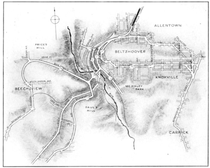
A plan showing the thoroughfare extensions from the proposed South Hills tunnel. Figures refer to the descriptive paragraphs in the text
72. (a) Washington Avenue Improvement.—Washington Avenue forms too steep a line up to the tunnel from the valley thoroughfares—the West Liberty Road and the Sawmill Run Road proposed above (Section 71). A reasonable gradient can be secured by raising the grade of the West Liberty Road north from the West Side Belt railroad bridge to Kaiser Avenue, thence running a bridge north across the valley, then climbing gradually northward along the hillside and joining Washington Avenue just below the Castle Shannon railroad bridge. Above this point Washington Avenue should be regraded by cutting at the top of the steep portion, thus getting an easy gradient to the new tunnel.
(b) Southern Avenue Connection.—From a point just below the Castle Shannon railroad bridge a branch connection should be run west across the valley to Boggs Avenue, about at Minsinger Street, thus connecting the new tunnel with Boggs and Southern Avenues leading to Mt. Washington.
73. (a) Beechview Thoroughfare.—The higher lands to the south, upon which most of the future development will take place, can best be reached by a street around the west end of the Beltzhoover ridge at, or slightly above, the level of the Castle Shannon railroad, about the location of the present Boggstown Avenue. From a point two or three hundred feet east of Sylvania Street a sloping viaduct should be run southwest up over the street railway bridge and the West Side Belt tracks to the nose of the opposite hill. From here a new street should be run west climbing gradually along the north slope of the hill to the high land at the northern end of Beechview. An extension of this line should then be made from Crane Street and Center Avenue southerly along the west side of the Beechview ridge joining Seventh Avenue just south of South Sharon Avenue. Beechview and the West Broadway thoroughfare, running south along the ridge, can thus be reached on a gradient under 4 per cent instead of 6½ or 7 per cent along the present street car right-of-way, or considerably more than that on the present streets. The viaduct from Southern Avenue to Price's Hill, proposed in the recent bond issue program, has been studied with some care, but the steep gradients it would require—6 per cent or over—to reach the hilltop land have led to its abandonment in favor of the plan just proposed.
(b) West Broadway Extension.—West Broadway should be extended along the present street car route from Snyder Street south to the junction of the Banksville and West Liberty Roads.
(c) Lang Avenue Connection.—Starting again from the southerly end of the above proposed viaduct over Sawmill Run, a street should be built running south over the West Liberty road and striking the opposite hillside at or just above Lang Avenue. Southwest from here, nearly to Summerhill Street, Lang Avenue should be shifted slightly down the hillside to reduce its gradient from about 12 to 4 or 5 per cent.
(d) Sawmill Run Hillside Thoroughfare.—Returning now to the northerly end of the proposed viaduct over Sawmill Run, the thoroughfare from Washington Avenue should be extended south along the Castle Shannon railroad to the Library Road at Oak Station. The road should be built on the uphill side of the tracks to facilitate running branch roads to the high country east thereof. If the Sawmill Run valley shall become park land[20] this new street will be a border drive with a commanding location overlooking the park.
74. Fairhaven County Road.—Just south of Fairhaven the county road climbs the hill to the Brownsville Road on a 10 per cent gradient. This can easily be reduced one half by shifting the road a little west, down the hillside, and reaching the high land twelve hundred feet farther south.
75. Carrick Connection from the South Hills Tunnel.—Perhaps the most important district to be reached, via the proposed South Hills tunnel, is that tapped by the Brownsville Road, i. e. Mount Oliver, Lower Saint Clair, Carrick and most of Baldwin township. To serve this district requires a thoroughfare connection past the bad gradients of the Beltzhoover ridge, to Brownsville Road at or beyond Charles Street.
There appear to be two possible routes for such a connection.
The shorter is as follows: along Washington Avenue east to Curtin Avenue, thence diagonally southeast to Climax Street, along Climax Street widened to a point about 200 feet east of Allen Street and thence diagonally southeast and through a short tunnel under the ridge to the corner of Charles and Amanda Streets. Amanda Street connects south to the Brownsville Road; and Charles Street, if widened straight through to the Brownsville Road, would furnish a reasonably direct connection with Arlington Avenue leading along the ridge to the east. This route could probably be brought to a very reasonable gradient, say 3½ per cent as a maximum.
The other route is by a new street rising around the northerly end of the Beltzhoover ridge and connecting with Michigan Street. The latter would be widened and regraded, cutting through the two narrow ridges over which it now humps at Gearing Street and Estella Avenue. These streets would be carried over it by bridges at the present grade. The improved Michigan Street would be connected with Charles Street; and the latter would be widened and improved in gradient, with another separation of grades at Knox Avenue where there is now a sharp hump in the Charles Street profile. Instead of following Charles Street through to a right-angle corner at Amanda, the thoroughfare might curve at the end so as to join Amanda Street a block or two farther south. This route is at least two thousand feet longer than the other, but if the mouth of the tunnel is not dropped too low, it can probably be brought to a maximum gradient of not over 3¼ per cent.
In the absence of complete and accurate information as to grades and distances throughout these two routes, it is impossible to say which is to be preferred. If, upon further study on the basis of reliable topographical data, it should develop that a materially better gradient can be secured by the longer route, that line would be the more desirable. But if the saving in gradient should prove to be very slight, perhaps not more than a third or a half of one percent, it is believed that the shorter route, that via Climax Street, should be adopted.
76. Arlington Avenue and Washington Avenue Connection.—Arlington Avenue is the direct road east from the junction of Washington Avenue and the Brownsville Road, but between this point and South Eighteenth Street it has two bad gradients, 7 per cent and over. To get a good cross-town connection without such gradients and at the same time to give better access to the Mount Oliver incline, Washington Avenue should be widened east from the Knoxville incline to Amanda Street,[21] and thence cut through on a curve to the corner of Angelo and Mount Oliver Streets. By widening Mount Oliver and Freeland Streets, by rounding off the east corner of Amanda and Freeland Streets and by cutting back the southwest corner of Freeland and South Eighteenth Streets, a nearly level, though somewhat circuitous, connection can be secured between Washington Avenue on the west and Arlington Avenue on the east.
77. South Eighteenth Street.—Plans have been proposed, by the Bureau of Surveys, to widen, pave and otherwise improve South Eighteenth Street from the South Side up the hill to Arlington Avenue. The gradient, which is now about 7 per cent, cannot be improved without very radical and costly changes in the street location; and since the proposed South Hills tunnel will reach, on easy gradients, practically all the hilltop territory now served by South Eighteenth Street, the trouble and cost of materially reducing the South Eighteenth Street gradient seems hardly justified.
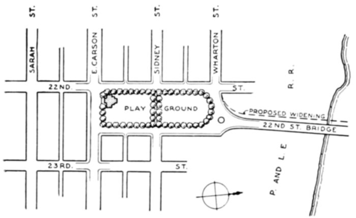
Diagram No. 13. Twenty-second Street bridge approach—South Side
The plans of the Bureau of Surveys propose a roadway width of 40 feet with two sidewalks each 10 feet wide in some places and in others 7½ feet. This means a widening of from 5 to 20 feet. As this entire section of South Eighteenth Street is on a hillside mostly steeper than one in three, such widening will require from 2 to 7 feet of additional retaining wall, or excessive cutting and filling, which means large damage to property in the vicinity. Furthermore, the adjacent hillsides are so steep that no extensive development of abutting property is likely to take place.
In consideration of all these points it is urged that a width of not less than 45 feet nor more than 50 feet be adopted in the improvement plans. This will give a roadway 35 feet and one sidewalk 10 feet or more in width.
78. Brownsville Road.—The Brownsville Road, climbing the hill from Carson Street, is similarly situated. Any improvements which may be contemplated therein should be governed by the same considerations as those cited above in connection with South Eighteenth Street.
79. South Tenth Street.—From the south end of the Tenth Street bridge to Muriel Street, South Tenth Street is cramped down to a total width of 45 feet, with a roadway only 26½ feet wide, because of a freight area 10 or 12 feet wide next to the Oliver Iron and Steel Company building. This area should be covered and the street widened.
80. Twenty-Second Street Bridge Approach—South Side.—The approach from East Carson Street to the Twenty-second Street bridge is cramped and crooked. The corner from the bridge into Wharton Street should be rounded back and an additional approach should be run along the east side of the playground. Some additional playground space can be secured by closing Sidney Street, between South Twenty-second Street and South Twenty-third Street, except for pedestrians. (Diagram No. 12.)
Several other changes in the outlying thoroughfares are marked in red on the accompanying plan but are not specifically noted in this report. They are suggested changes to improve certain steep gradients but have not been thoroughly studied on the ground.
SUBJECT INDEX TO OUTLYING THOROUGHFARE IMPROVEMENTS
Section Page
Allegheny River Boulevard 61 79
Ardmore Thoroughfare 42 73
Arlington Avenue and Washington Avenue Connection 76 85
Aspinwall Bridge 10 59
Batavia Street 33 71
Bates Run Connection 15 63
Baum Street Improvement 20 65
Beechview Thoroughfare 73a 83
Beechwood Boulevard Connection 28 68
Beechwood Boulevard Re-alignment 31 70
Bell Avenue Extension 41 73
Boundary Street Improvement 29 69
Braddock Avenue—Northerly End 36 72
Braddock Avenue Viaduct 37 72
Brighton Road Viaduct 53 76
Brownsville Road 78 86
Butler Street Improvement 8 59
California Avenue and Brighton Road Extension 52 75
Carrick Connection from the South Hills Tunnel 75 84
Carson Street 64 79
Center Avenue Improvement 21 65
Chartiers Avenue Grade Crossing 65 80
Corliss Street 67 80
Crafton-Carnegie Connection 69 81
Crafton Hillside Thoroughfare 68 81
Dravosburg and Mifflin Township Thoroughfare 47 74
Duquesne Bridge 51 75
East Ohio Street 57 77
East Street 54 76
Eighth Avenue Branch to Dravosburg 50 75
Eighth Avenue Branch Westward 49 75
Eighth Avenue Improvement 48 75
Ellsworth Avenue Extension 13 62
Etna Improvement 59 78
Fairhaven County Road 74 84
Fifth Avenue—Center Avenue Connection at Soho 12 61
Forbes Street Extension 39 72
Forbes Street—Fifth Avenue Connection at Soho 11 60
Forty-third Street Bridge 6 59
Glenwood Bridge 19 64
Greenfield and Squirrel Hill Extension 17 64
Greenfield Avenue Connection 16 64
Greensburg Pike 44 74
Greensburg Pike South of Turtle Creek 45 74
Haights Run Bridge 9 59
Haights Run Thoroughfare 25 67
Hamilton Avenue Extension 22 65
Hazelwood Grade Crossing 18 64
Lang Avenue Connection 73c 83
Larimer Avenue Extension 24 66
Lowry's Lane 56 77
Main Street Grade Crossing 62 79
Meadow Street Connections 26 68
Millvale Thoroughfare 58 78
Monongahela Hillside Thoroughfare 14 62
Murray Avenue Extension 30 69
Negley Run Boulevard 23 66
Penn-Liberty Connection at Howley Street 5 58
Rankin Improvement 38 72
Sassafras Street Outlet 4 58
Sawmill Run Hillside Thoroughfare 73d 83
Sawmill Run Thoroughfare 71 81
Second Avenue Extension 32 70
Sharpsburg Bridge 7 59
Sixteenth Street Bridge 1 56
South Eighteenth Street 77 85
Southern Avenue Connection 72b 82
South Tenth Street 79 86
Squaw Run Thoroughfare 63 79
Stanton Avenue Connection to the Lincoln District 27 68
Streets Run 46 74
Sycamore Street Grade Crossing and Bridge Street Improvement 60 78
Thirty-third Street Improvement 3 57
Troy Hill Road 55 77
Twenty-eighth Street Grade Crossings 2 57
Twenty-second Street Bridge Approach—South Side 80 86
Washington Avenue Improvement 72a 82
Washington Road 70 81
West Broadway Extension 73b 83
Wilkinsburg-Edgewood Connection 35 71
Wilkinsburg Grade Crossings 34 71
Wilkins Township Thoroughfares 43 73
Wind Gap Road 66 80
Woodstock Avenue Extension 40 73
NUMBER INDEX TO OUTLYING THOROUGHFARE IMPROVEMENTS
Section Page
1 Sixteenth Street Bridge 56
2 Twenty-eighth Street Grade Crossings 57
3 Thirty-third Street Improvement 57
4 Sassafras Street Outlet 58
5 Penn-Liberty Connection at Howley Street 58
6 Forty-third Street Bridge 59
7 Sharpsburg Bridge 59
8 Butler Street Improvement 59
9 Haights Run Bridge 59
10 Aspinwall Bridge 59
11 Forbes Street—Fifth Avenue Connection at Soho 60
12 Fifth Avenue—Center Avenue Connection at Soho 61
13 Ellsworth Avenue Extension 62
14 Monongahela Hillside Thoroughfare 62
15 Bates Run Connection 63
16 Greenfield Avenue Connection 64
17 Greenfield and Squirrel Hill Extension 64
18 Hazelwood Grade Crossing 64
19 Glenwood Bridge 64
20 Baum Street Improvement 65
21 Center Avenue Improvement 65
22 Hamilton Avenue Extension 65
23 Negley Run Boulevard 66
24 Larimer Avenue Extension 66
25 Haights Run Thoroughfare 67
26 Meadow Street Connections 68
27 Stanton Avenue Connection to the Lincoln District 68
28 Beechwood Boulevard Connection 68
29 Boundary Street Improvement 69
30 Murray Avenue Extension 69
31 Beechwood Boulevard Re-alignment 70
32 Second Avenue Extension 70
33 Batavia Street 71
34 Wilkinsburg Grade Crossings 71
35 Wilkinsburg-Edgewood Connection 71
36 Braddock Avenue—Northerly End 72
37 Braddock Avenue Viaduct 72
38 Rankin Improvement 72
39 Forbes Street Extension 72
40 Woodstock Avenue Extension 73
41 Bell Avenue Extension 73
42 Ardmore Thoroughfare 73
43 Wilkins Township Thoroughfares 73
44 Greensburg Pike 74
45 Greensburg Pike South of Turtle Creek 74
46 Streets Run 74
47 Dravosburg and Mifflin Township Thoroughfare 74
48 Eighth Avenue Improvement 75
49 Eighth Avenue Branch Westward 75
50 Eighth Avenue Branch to Dravosburg 75
51 Duquesne Bridge 75
52 California Avenue and Brighton Road Extension 75
53 Brighton Road Viaduct 76
54 East Street 76
55 Troy Hill Road 77
56 Lowry's Lane 77
57 East Ohio Street 77
58 Millvale Thoroughfare 78
59 Etna Improvement 78
60 Sycamore Street Grade Crossing and Bridge Street Improvement 78
61 Allegheny River Boulevard 79
62 Main Street Grade Crossing 79
63 Squaw Run Thoroughfare 79
64 Carson Street 79
65 Chartiers Avenue Grade Crossing 80
66 Wind Gap Road 80
67 Corliss Street 80
68 Crafton Hillside Thoroughfare 81
69 Crafton-Carnegie Connection 81
70 Washington Road 81
71 Sawmill Run Thoroughfare 81
72a Washington Avenue Improvement 82
72b Southern Avenue Connection 82
73a Beechview Thoroughfare 83
73b West Broadway Extension 83
73c Lang Avenue Connection 83
73d Sawmill Run Hillside Thoroughfare 83
74 Fairhaven County Road 84
75 Carrick Connection from the South Hills Tunnel 84
76 Arlington Avenue and Washington Avenue Connection 85
77 South Eighteenth Street 85
78 Brownsville Road 86
79 South Tenth Street 86
80 Twenty-second Street Bridge Approach—South Side 86
LOCATION MAP FOR 80 IMPROVEMENTS IN THE OUTLYING THOROUGHFARES
(ATTACHED OPPOSITE THIS PAGE 92)
MAP OF THE PITTSBURGH DISTRICT