Chapter II · (continued 3)
Reading edition
Some idea of the magnitude of the changes wrought in Mount Mazama by the events recorded in its geology and topography may be obtained from the following facts: Crater Lake has a surface elevation of 6,239 feet above the sea, and is nearly 2,000 feet deep in its deepest part; the precipices surrounding it are from 520 to 1,987 feet high. The whole depth of the depression is therefore 4,000 feet. This caldera, as such basins of volcanic origin are termed, is nearly circular, with an east and west diameter measuring 6 miles, and a north and south diameter of 5 miles. The volume of the pit is nearly 12 cubic miles.
Not only is Mount Mazama with its wonderful lake one of the most unique natural features of North America, but it has its full share of the artistic details of lake and mountain scenery which appeal so forcibly to the finer instincts within us. The outer slopes of the mountain are clothed with the all-embracing coniferous forests which cover the Cascades as with a mantle throughout their entire extent, while the precipitous inner slopes are for the most part bare precipices of angular and extremely rugged rock. The lake itself is of the most marvellous blue, in which the encircling cliffs, the crater-island, and the sky above are reflected.
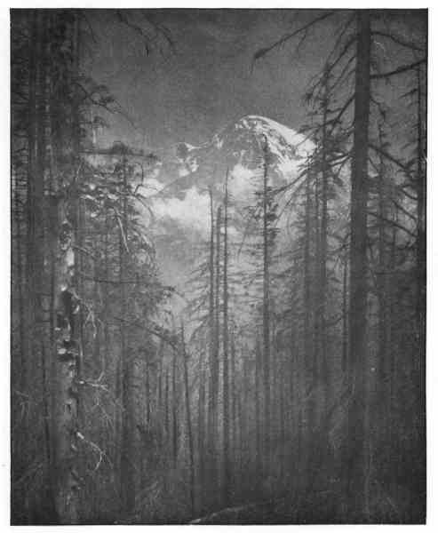
Fig. 22.—Mount Rainier, Washington.
Other peaks along the crest-line of the Cascades to be numbered by the score, although with less romantic histories than Mount Mazama, have instructive answers to give when properly questioned. Among the remarkably picturesque summits rising above the dark coniferous forests of western Oregon are the following, with their respective heights above the sea expressed in feet: Mount Pitt, 9,760; Mount Mazama, 8,228; Mount Union, 7,881; Mount Scott, 7,123; Three Sisters, Mount Jefferson, 10,200; and Mount Hood, 11,225. Of these peaks, the best known, on account of its proximity to the city of Portland, and at the same time one of the most picturesque and beautiful, is Mount Hood, situated about 25 miles south of the Columbia River. The concave slopes so characteristic of volcanic cones are no longer conspicuous on the sides of this once symmetrical mountain, and only remnants of its crater remain. The part it played as a safety-valve for the pent-up energy beneath was long since finished, although heated vapours still escape from an opening near the summit. Similar manifestations of heat have also been observed about several other ancient craters in the Cascades, but these occurrences are not considered as indicating that actual connections still exist with reservoirs or bodies of molten rocks below the surface: they are evidently due to the residual heat of the once molten rock in the conduits of the now extinct or dormant volcanoes.
The lava-flows and volcanic mountains typically displayed in the Cascades throughout the breadth of Oregon continue northward and form at least the surface portion of the same range in Washington as far as the Northern Pacific Railroad, or about 100 miles north of the Columbia. The more important volcanic mountains in western Washington are, in their order from south to north; as follows, the height of each being given in feet: Mount Adams, 9,570; Mount St. Helens, 9,750; Mount Rainier, 14,525; Glacier Peak, 10,436; and Mount Baker, 10,877. Only two of these ancient volcanoes, namely, Mount Adams and Glacier Peak, are situated on the crest-line of the Cascade Mountains; the others are to the westward and more or less completely detached from the main range.
The Cascade Mountains are in general parallel with the shore of the Pacific, and rise as a prominent barrier athwart the path of the prevailing westerly winds. Precipitation on their seaward slopes is copious, but their landward sides overlooking the arid plains of central Washington are far less humid. The westward, or rainy slope, is clothed with a magnificent forest of giant trees, while the eastward, or sunny side, is largely without forests, but abounds in natural meadows and pastures. Large portions of the mountains are still almost entirely unknown, and retain their primitive wildness, except that forest fires, particularly near the international boundary, have in places made desolate the once beautiful valleys and precipitous slopes. Elk, deer, bear, the mountain-goat, and mountain-sheep still roam the forests. The large streams abound in salmon, and each cool, clear brook and rushing creek is a favourite haunt of the trout. No more delightful camping-ground for lovers of nature and searchers for recreation can be found than the grassy, park-like valleys on the sunny side of these magnificent mountains.
Many of the details in the scenery of the Cascades are due to the work of ancient glaciers. Numerous lakes, held in rock-basins in the higher portions of the mountains, and many still larger sheets of water retained by morainal dams in the lower valleys, give a superlative charm to many a wild and rugged landscape. The largest and most interesting lake in the entire Cascade region is Lake Chelan, situated in a deep valley on the eastern side of the mountains in north-central Washington. This beautiful sheet of water, a mile or two wide, extending like a placid river for some 70 miles into the mountains, resembles in many of its features the far-famed lakes of northern Italy. The mountains inclosing this hidden gem of the Cascades rise abruptly from the water's edge to great heights, and with one exception are unbroken by deep side-valleys. For fully 50 miles the blue plain of water is overshadowed on each side by crags and precipices from 5,000 to 6,000 or more feet in height. The lower slopes are dark with forests of pine and fir, and the bare serrate spires above are white with snow long after the spring flowers have faded in the lower vales. The water of the lake is clear and sparkling, and has the deep-blue colour of the open ocean. The sounding-line has shown a depth of 1,400 feet, and the bottom is about 300 feet below sea-level. This wonderful lake, clasped in the embrace of the eastward extended arms of the Cascades, is but 2 or 3 miles from the Columbia River, into which it discharges its surplus waters through Chelan River, and may be easily reached from Wenachee, on the Great Northern Railroad, by steamers on the Columbia. Although at present scarcely known to the world of tourists, Lake Chelan is destined to take as an important place in the lives of those who seek rest and recreation as does Lake George in northern New York at the present day.
Before attempting to trace the Pacific mountains northward through Canada and Alaska, let us glance at the leading geographical features to the west of the Sierra Nevada-Cascade uplift.
THE GREAT VALLEY OF CALIFORNIA AND THE PUGET SOUND BASIN
To the west of the Sierra Nevada-Cascade Mountains, and bordered on the west by another and very nearly parallel series of elevations, known in a general way as the Coast Mountains, there is a succession of long, relatively narrow basins, situated end to end, and constituting what may be termed a valley-chain. This series of basins extends from southern California northward far into Canada, and includes, in their order from south to north, the great Valley of California, the Willamette and Cowlitz Valleys in Oregon and Washington, and the Puget Sound basin, together with its great but indefinitely defined northward extension.
The Great Valley of California has a length of about 500 miles and an average width of approximately 40 miles, and is greater in area than either Belgium, Denmark, or Switzerland. It is divided in reference to drainage into two portions, the San Joaquin Valley at the south and the Sacramento Valley at the north, named respectively after the rivers that drain them. These two streams unite and discharge into San Francisco Bay, the outlet of which is through the Golden Gate to the Pacific. This central basin of California has a generally flat bottom composed of a great depth of unconsolidated gravel, sand, and clay, which are believed to owe their deposition mainly to the streams flowing from the bordering mountains, although in part they may have been deposited when the land was more depressed than now and the basin was a great sound, connected with the ocean by a single narrow opening. The rock-waste swept into the valley served not only to add to the accumulations forming its floor, but to give the bottom some irregularities. A portion of its southern end, shut off by alluvial deposits brought down from the Sierra Nevada, is occupied by the shallow alkaline waters of Tulare Lake. When the great valley was first visited by white men it was without trees, except along the immediate borders of some of the streams, and for the most part was a luxuriant meadow of wild grasses and flowers. On the uplands oak-trees grew in scattered park-like groves with gorgeously flower-decked hills and vales between. This favoured land, clothed in its natural beauties, came as near being an Eden as perhaps any portion of the continent. The changes that have followed the settlement and cultivation of this great mountain-inclosed basin are simply marvellous. Cities and villages have been built, orchards and vineyards planted which yield most bountiful harvests, and the once grass-covered plains are now seemingly boundless wheat-fields. The unkept natural garden of half a century ago has become a granary not only for the people of America, but for those of Asia as well.
To the north of the Klamath Mountains, which shut in the central Valley of California at the north, lies the beautiful Willamette Valley, about 150 miles long, drained by the northward-flowing river of the same name, which joins the Columbia where the thriving city of Portland now stands. The depression between the mountains of which the Valley of the Willamette forms a part, extends north of the Columbia, and is there drained by the southward-flowing Cowlitz River. The relation of these two valleys is much the same, although on a smaller scale, as that existing between the San Joaquin and Sacramento Valleys, except that the Columbia, after passing through the Cascade Mountains, receives the Willamette and Cowlitz rivers as tributaries, one from each side of its course. This Willamette-Cowlitz depression is surrounded by densely forested hills and the snow-capped summits of ancient volcanoes. The soil was originally highly fertile, and although now somewhat impoverished, still furnishes a substantial basis for agriculture, and renders the region one of the most productive as well as most beautiful in the United States.
To the geographer the Willamette-Cowlitz Valley seems scarcely distinct from the great depression farther north in the same valley-chain, which now holds the waters of Puget Sound, except that there is a low water-parting between. This divide, as previously suggested, is thought to be due largely to stream and glacial deposits, which have been laid down in the previously nearly level-floored intermontane trough.
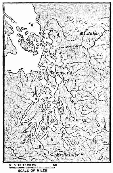
The Puget Sound basin has a length from south to north of about 150 miles, and extends from the Olympic Mountains on the west to the Cascade Mountains on the east, a distance of some 60 miles. The sound terminates at the north at the Strait of Fuca (at Port Townsend, in Fig. 23), but the depression in which it lies continues northward, with similar geographical and geological characteristics. In a general way the same depression may be said to extend northward to southeastern Alaska, but is there deeply water-filled, and its western border is discontinuous and broken into many islands.
There are several features in the Puget Sound basin which especially impress the traveller: Next to the magnificence of the lofty volcanic cones that stand like Titan watch-towers along the western slope of the Cascades and the dense forest of gigantic firs and cedars, the most conspicuous feature of the region is the extreme irregularity of the sound itself. Even such general maps of Puget Sound as are usually available indicate that it is exceptional and different from all other water bodies on the continent, not including the extension of the same series of basins northward. Not only is Puget Sound extremely irregular, and inconsistent with any theory that would ascribe its origin to the subsistence and drowning of stream-eroded valleys, but its waters are deep and the channels narrow. The uplands between the waterways are low plateaus composed of clay, gravel, and glacial moraines. The explanation of these unique conditions is that glacial ice formerly occupied the basin and deposited moraines and gravel-plains and clay-plains about its margins; when the branching and irregular sheet of stagnant ice melted its place was taken by the waters of the sea. This simplified outline of the later history of Puget Sound has many modifications, the most important being that there were at least two periods of ice occupation, with an intervening stage of mild climate between, during which the previously formed glacial deposits were forest covered and thick beds of peat formed.
Fig. 23.—Puget Sound.
The ice which occupied Puget Sound was the extreme southern portion of a great but irregular Piedmont glacier which fringed the rough and ragged coast of the continent all the way to southern Alaska. A remnant of this former ice body still exists near Mount St. Elias, and constitutes the very instructive Malaspina glacier.
THE MOUNTAINS BORDERING THE PACIFIC
In a preceding chapter the rugged topography of the western margin of the continent has been briefly described, and a general explanation given of the contrasts which it presents to the coastal plains and plateaus on the Atlantic border.
The long, narrow peninsula known as Lower California, as yet unstudied in the light of modern geography, is known to be mountainous throughout. Although nearly surrounded by the waters of the ocean, the climate of the peninsula is hot and arid and its surface desert-like. The Gulf of California, which separates such a large portion of the Pacific border of Mexico from the main body of the republic, has the characteristics of a drowned intermontane or orogenic valley. But whether the great depression was ever dry land or not is unknown. The waters of the gulf are shallow, however, and a moderate upward movement of the earth's crust in that region would transform it into a great valley similar in its general features to the central basin of the State of California.
What are frequently designated collectively as the Coast Mountains begin at the south and adjacent to the shore of the Pacific, in the vicinity of Santa Barbara, Cal., and extend northward along the immediate seaboard far into British Columbia. A continuation or branch of this series of elevations follows the south coast of Alaska, and is prolonged so as to form the Aleutian Islands. The length of the mountain system or succession of ranges referred to is between 3,500 and 4,000 miles. The detailed study of this long, narrow, and in many parts excessively rugged region is as yet in its infancy, and only a brief account of its salient features can be attempted at present.
In southern California the structure of the mountains and the deep stream-deposited gravel, etc., in the intervening valleys, as well as the aridity of the climate and character of the vegetation, correspond closely with the similar conditions in the Great Basin. In fact, the Great Basin region, as the term has been used on a previous page, there meets the Pacific, and the islands rising from the adjacent portion of the ocean seem to be the summits of mountains of the Basin Range type. Owing to the dryness of the climate in southern California and adjacent portions of Mexico, the deeply alluvial-filled valleys are treeless, and agriculture is only possible with the aid of irrigation. Where water can be had, however, there are wonderfully productive orchards, vineyards, and gardens, in which the fruits and flowers of both the temperate and torrid zones flourish side by side with marvellous luxuriance. The palm there casts its shadow on fragrant bowers of the most superb roses. The grass-clothed mountain slopes are either bare of trees or but scantily forested, while the upland valleys produce a dense jungle of native trees and shrubs.
To the north of the irregular and diversified portion of southern California, where the Great Basin region extends southwestward to the Pacific, rises the southern Coast Range of California. The indefinite beginning of this range is in the neighbourhood of Point Conception, to the north of Santa Barbara, and its northern terminus is at the Golden Gate. The same belt of mountains extends northward, however, and forms the northern Coast Range, which extends to the Klamath Mountains in northern California. The coast ranges of California as a whole are about 500 miles long and from 30 to 40 miles broad, and comprise several seemingly distinct uplifts, some of which have culminating peaks from 4,000 to about 7,000 feet high. In general this elevated region is conspicuously sculptured, and in part at least has the characteristics of an eroded plateau. The suggestion has been offered that the northern portion of the Coast Range is a dissected peneplain.
The Coast Ranges, although generally bare of trees to the south of the Golden Gate, become more and more densely forested when followed northward. It is in this northern division that the great forests of redwood occur, now so largely used for lumber. Reference is here made not to the "big trees," which grow in certain restricted areas on the west slope of the Sierra Nevada, but to the far more extensive forests of a related species.
Considering mountain forms simply, it is difficult if not impossible to determine where the Coast Mountains of California terminate at the north, but, as has been shown especially by J. S. Diller, there are reasons based on geological structure for separating them from the irregular group of ranges and peaks in northern California and southern Oregon recently named the Klamath Mountains. The coast system is continued north of the Klamath Mountains by the Coast Mountains of Oregon, which extend to the Columbia River, and consist of irregular ridges or series of ridges, with bold lateral spurs, especially on the ocean side. It varies conspicuously in height from place to place, yet nowhere attains a great altitude. The elevations of the bolder summits, although not accurately measured, seldom exceed 3,000 feet.
The Coast Mountains of Oregon are considered as terminating at the northern boundary of the State, there defined by the Columbia River, but no reason is apparent, however, for not including in the same group the elevated land lying in southwestern Washington and adjacent to the Pacific coast. Between the Columbia and Chehalis River in Washington there is a rugged region which attains an elevation of over 4,000 feet, and is separated from the Olympic Mountains to the northward by Chehalis Valley. Although the geology of this group of ridges and peaks is entirely unknown, its position and general appearance, when seen from a distance, suggest that it might properly be considered as a direct extension of the Coast Mountains of Oregon.
Following the general belt of the Coast Ranges still farther northward, we come to the splendid group of forest-clothed mountains, with usually snow-covered summits, situated to the west of Puget Sound, and known as the Olympic Mountains. This magnificent range is in full view from Victoria, Seattle, and Tacoma, and would be far-famed for its grandeur were it not for its near rival, the still more lofty Cascade Range.
There are several fine, sharp peaks in the Olympics that have never been scaled, the highest of which, Mount Olympus, rises 8,150 feet above the sea. Owing to the excessive humidity and other favourable climatic conditions, these mountains are clothed with magnificent forests up to an elevation of about 7,000 feet. On account of the ruggedness of the country, the extreme density of the tangled undergrowth, and the obstructions formed by the fallen moss- and lichen-covered trees, this region is extremely difficult to traverse, and to-day is the least known of the continental portion of the United States. On the north the excessively rugged Olympic peninsula is bordered by a deep, broad fiord known as the Strait of Fuca. To the north of this formerly ice-filled channel lies Vancouver Island, the central and northern portion of which is mountainous. The highest summit on the island rises about 7,500 feet above the sea, and a considerable area in its central part has an elevation of over 2,000 feet.
The Olympics, together with the mountains of Vancouver and Queen Charlotte Islands, and the northern extension of the same belt, embraced in part within the mainland of British Columbia and southeastern Alaska, have been termed the "Vancouver Mountains" by Canadian geographers. The northern boundary of this mountain system, justly named in honour of the celebrated English explorer who mapped large portions of the northwest coast about a century since, remains indefinite, and cannot be determined until geologists have made more thorough explorations of the land it occupies. The leading geographical features of this region, as remarked in a preceding chapter, are due to the deep dissection, by streams and glaciers, of an elevated table-land. When the ice-streams melted, the sea was permitted to enter the valleys, so as to form numerous deep, narrow, steep-walled fiords (Fig. 11). The coast is, in fact, the most ragged of any portion of the border of the continent. All but the higher summits are clothed with a dense mantle of vegetation, the upper limit of which decreases in elevation when followed northward, from about 7,000 feet in the Olympics to approximately 2,500 feet in southern Alaska. Perennial snow exists in the higher valleys and amphitheatres of the Olympics, but the presence of true glaciers in that group of peaks has not been demonstrated. When followed northward the snow-line becomes lower and lower, and well-defined alpine glaciers are known to exist in many of the valleys, more especially on the mainland of British Columbia and southeastern Alaska. There streams of ice descend lower and lower with increase in latitude, and to the north of Stickeen River, in a number of instances, enter the fiords which connect with the ocean and become tide-water glaciers.
To the west of Lynn Canal, and extending to beyond Copper River, is the most rugged portion of North America, and contains also some of the highest mountain-peaks on the continent thus far measured.
The region of high mountains in Alaska and the adjacent portion of Canada begins on the east in the group of magnificent peaks which cluster about Mount Fairweather as a centre and extend westward, with a breadth of some 80 miles, to beyond Mount St. Elias. Farther westward, beyond Copper River, other great mountains are known to exist. One of these, Mount McKinley, has an elevation of 20,400 feet, and so far as now known is the highest peak in North America.
The highest summit to the east of Copper River is Mount Logan, 19,500 feet. This superb ice-sheathed peak is situated in Canada about 40 miles from the coast and 12 miles east of the one hundred and forty-first meridian. Second in rank is Mount St. Elias, 18,070 feet, situated close to the one hundred and forty-first meridian, and within the territory belonging to the United States. These two summits are the highest in a land of lofty snow-covered mountains, and for this reason have claimed a large share of attention. There are many neighbouring peaks, however, that are wonderfully magnificent, but only a few of them have been measured and many of them are still unnamed. Only one of the high mountains of Alaska, namely, Mount St. Elias, has been climbed. This splendid feat of mountaineering was accomplished by Prince Luigi, of Savoy, in 1899.
In southern Alaska the snow-line is only about 2,500 feet above tide, and a large number of magnificent glaciers descend to sea-level, and many of them actually enter the ocean. All of the valleys and basins among the higher summits are occupied by snow-fields and glaciers. The general covering of ice and snow as well as the ruggedness of the land makes this the most difficult of all the mountainous portions of North America to traverse.
In the St. Elias region the mountains have been produced by upheaval, and are not volcanic in their origin. The frequently repeated statement that Mount St. Elias is a volcano is incorrect. Although igneous rocks occur near its summit, they are of the nature of dikes or intrusions, probably of ancient date, and not lava-flows. The principal volcanic mountains of Alaska are farther west in the region of the Alaskan peninsula and the Aleutian Islands. This western extension of the continent is excessively rugged, but the mountains rise directly from the ocean and in part form a chain of precipitous islands with irregular topographic forms.
There are mountain ranges also in the central and northern portions of Alaska and the adjacent part of Canada, but this region awaits exploration, and but little accurate information concerning its topography is on record.
The Mountains of Western Canada.—Reference has already been made to the differences in the nomenclature applied to the portions of the Pacific mountains on opposite sides of the United States-Canadian boundary, and at present this lack of harmony cannot be adjusted. As is well known, the great Pacific cordillera crosses the boundary nearly at right angles, and there is no abrupt change in the topography of the land. From the western border of the Great plateaus to the Pacific, between the forty-fifth and fifty-sixth parallels, as stated by the Geological Survey of Canada, the cordillera has an average breadth of about 400 miles, and is composed of four great mountain chains, named in their order from east to west, the Rocky, Gold, Coast, and Vancouver Mountains. These four great chains are nearly parallel and have irregular northwest and southeast trends.
The Canadian Rockies rise abruptly from Great plateaus in which the rocks are nearly horizontal, and have a complex structure, due to the folding and other disturbances that have affected the strata. Deep dissection by stream erosion has occurred, as is the case generally throughout the Pacific cordillera, and the peaks and ridges remaining are remarkable for their grandeur. Although less elevated than the higher portions of the same great belt in the United States, many of the summits are from 8,000 to 10,000, and, as reported, in a few instances reach 13,000 feet in height, while the passes range is elevated from about 4,000 to 7,000 feet. The western border of the Rocky Mountain range is well defined for a distance of some 700 miles to the northward of the international boundary by a remarkably straight, wide valley, which is occupied by the head waters of several large rivers, namely, the Kootenay, Columbia, Fraser, Parsnip, and Findley. To the west of the great valley just referred to rises the Gold system, composed principally of the Selkirk, Purcell, Columbia, and Caribou Ranges. It is in this rugged region that some of the most remarkable of the splendid scenery of western Canada occurs.
To the west of the Gold system is a broad region of valleys and lesser mountains, known as the interior plateau of British Columbia, which is a northward extension of the Great Basin region of the United States. The breadth of this belt of comparatively low country is about 100 miles. Like the similar region in Washington and Oregon, it is without forests, but favourable as a grazing country. In part it is occupied by extensive lava-flows, similar to the Columbia River lava of the northwestern part of the United States.
The Coast Mountains of Canada, although stated by geologists to be distinct from the Cascade Mountains, are in part at least, as determined by the present writer, a direct northward extension of that range. The average elevation of the higher peaks in the Canadian Coast Range, as it is termed, is between 6,000 and 7,000 feet, while the culminating points reach an elevation of about 9,000 feet. How far northward the nomenclature applied to the Pacific mountains in southwestern Canada will be found applicable can not be stated, as the region to the north of the fifty-sixth parallel is almost wholly unknown.
THE ANTILLEAN MOUNTAINS
As has been clearly pointed out by R. T. Hill, the Pacific cordillera ends at the south in south-central Mexico, while the Andean cordillera at its northern end terminates in the rugged mountains of Venezuela to the south of the Caribbean Sea. These two great cordilleras do not overlap, but there is a difference of about 10 degrees of latitude between them, and if extended they would pass each other at a distance of nearly 1,000 miles. In the space thus indicated, measuring some 600,000 square miles, is included the southern portion of Mexico, Central America, and the West Indies. The rocks in these countries present a great series of folds which trend in an easterly and westerly direction, and thus present a conspicuous exception to the major structural features of both North and South America. To this newly recognised division of the larger geological and geographical characteristics of the New World the name Antillean mountains has been given.
The folds or corrugations in the rocks of the Central American and Caribbean region extend in an east and west direction along the seaward margin of Venezuela and Colombia from the Orinoco westward to the Isthmus of Panama, and thence continue westward through Costa Rica, the eastern portions of Nicaragua, Guatemala, and Honduras, and reach southern Oaxaca in Mexico. The same system of plications is revealed also on the larger West India islands. The rocks of this great region include granite and allied metamorphosed terranes, old lavas, and sedimentary beds.
One of the most conspicuous features of this region with a structure and relief commonly found in mountains is that to a great extent it is depressed beneath the sea, and only the higher summits are in view. Some of the larger inequalities of the rock surface have been discovered by means of the sounding-line. By referring to Fig. 3, it will be seen that two submarine ridges extend in an east and west direction beneath the Caribbean Sea, from the West Indies to the Central American coast, and are separated by Bartlett Deep. These ridges correspond in trend with the longer axes of the folds in the Antillean mountains, and suggest a common origin for the leading geographical features of the land and of the still more remarkable topography of the sea-floor.
In addition to mountains produced by corrugation and upheaval, there are also in the middle American region numerous volcanic mountains. Of these there are two well-defined belts, each trending in general north and south, or directly across the longer axes of the folds of the Antillean mountains. One of these belts of volcanic cones and craters is situated on the Pacific coast of Central America and Mexico, and includes some 25 active volcanoes, and the other is defined by the numerous volcanic islands of the Lesser Antilles. The association of these belts of fracture through which molten rock has been extruded and where earthquakes are of common occurrence, with the junction of the east and west belt of plication to which the Antillean mountains are due, with the north and south belts of mountains forming the Pacific and Andean cordilleras, is significant in connection with the study of the origin of the larger features of the relief of the solid earth.
Varied as is the relief of North America when studied in detail, an outline sketch of its major features may be readily retained in mind. On the east side of the main continental area are the Atlantic mountains, extending from near the Gulf coast northward to beyond Hudson Strait; in the central part is the broad continental basin, a vast region of low relief reaching from the Gulf of Mexico to the Arctic Ocean; west of the continental basin are the Pacific mountains, the greatest of all the elevations on the continent, which begin abruptly in south-central Mexico and extend northward, expanding to a width of about 1,000 miles in the United States and reach the Arctic Ocean and Bering Sea. The movements in the earth's crust, which blocked out these major physiographic features, were produced by forces acting in east and west directions, and gave origin to folds and faults with their longer axes trending north and south. To the south of the main body of the continent, in middle America, are situated the Antillean mountains, also a cordillera comparable with the Atlantic and Pacific cordilleras, in which the longer axes of the folds and faults trend east and west, and are due to forces acting in north and south directions. The Antillean mountains in a general way connect or intervene between the Pacific and the Andean cordilleras. Where the Antillean mountains cross the axes of the Pacific and Andean cordilleras are situated the volcanoes of southern Mexico and Central America, and those of the Lesser Antilles.
Geographers will recognise that this outline is drawn boldly, but although it will no doubt have to be modified as detailed studies progress, it should serve to emphasize the leading geographic divisions of the North American continent when viewed as a whole.
LITERATURE
The following list of publications relating to the physiography of North America is here presented largely because the books mentioned contain bibliographies or references which indicate sources of more special information:
American Geographical Society, Bulletin. Published annually.
Canadian Geological Survey, Ottawa, Canada. Index to reports from 1863 to 1884, published in 1900.
Darton, N. H. Catalogue and Index of Contributions to North American Geology, 1732 to 1891. United States Geological Survey, Bulletin No. 127, Washington, 1896.
Davis, W. M. Physical Geography. Ginn & Co., Boston, 1898. Contains a valuable bibliography.
Dryer, C. R. Lessons in Physical Geography. American Book Company, New York, 1901. Contains a valuable bibliography.
Geological Society of America, Bulletin. Published annually since 1890 at Rochester, N. Y. Index to vols. i-x, published in 1900.
International Geography. Edited by H. R. Mill. D. Appleton and Company, New York, 1900. Contains several chapters on North America by various authors.
Journal of Geology. Edited by T. C. Chamberlin and published at the University of Chicago, Chicago, Ill.
Merrill, G. P. Rocks, Rock-Weathering, and Soils. The Macmillan Company, New York, 1897.
National Geographic Magazine. Washington, D. C.
National Geographic Monographs. American Book Company, New York, 1895. One volume published.
Powell, J. W. Exploration of the Colorado River of the West. Published by the Smithsonian Institution, Washington, 1875.
Powell, J. W. Cañons of the Colorado. Flood & Vincent, Meadeville, Pa., 1895.
Russell, I. C. Lakes of North America, Ginn & Co., Boston, 1895; Glaciers of North America, Ginn & Co., Boston, 1897; Volcanoes of North America, The Macmillan Company, New York, 1897; Rivers of North America, Putnam's Sons, New York, 1898; The Names of the Larger Geographical Features of North America, in Bulletin of the Geographical Society of Philadelphia, vol. ii, 1899, pp. 55-68.
Shaler, N. S. Nature and Man in America. Scribner's Sons, New York, 1891.
Stanford's Compendium of Geography and Travel. North America: Canada and Newfoundland, by S. E. Dawson; United States, by H. Gannett; Central America and West Indies, by A. H. Keane. Published by Edward Stanford, London.
Tarr, R. S. Elementary Physical Geography. Macmillan & Co., 1895.
United States Geological Survey. Bibliography and Index, contained in Bulletins No. 100, 127, 177, 188, and 189, issued by the Survey. The reader is referred especially to the Geological Atlas and the Topographic Atlas, published by the Survey.
Warman, P. C. Bibliography and Index to the Publications of the United States Geological Survey. United States Geological Survey, Bulletin No. 100, Washington, 1893. (Relates to publications of the United States Geological Survey issued previous to 1892; continued in Bulletin No. 177 by the same author.)
Warman, P. C. Catalogue and Index of the Publications of the United States Geological Survey, 1880 to 1901. United States Geological Survey, Bulletin No. 177, Washington, 1901.
Weeks, F. B. Bibliography of North American Geology, Paleontology, Petrology, and Mineralogy for the Years 1892-1900, inclusive. United States Geological Survey, Bulletins No. 188 and 189, Washington, 1902.
Whitney, J. D. The United States. 2 vols. Little, Brown & Co., Boston, 1889 and 1894.