Chapter I · (continued 2)
Reading edition
Changes in the Coast-Line due to Ice.—It is now well known that glacial ice many hundreds of feet thick formerly covered the northern half of North America and flowed outward across the present position of the coast-line throughout all of the northern border of the continent from Staten Island in the east and Puget Sound in the west, with the exception of the Arctic and Bering Sea coasts of Alaska.
The effects of this outward-flowing ice on the topography of the continental border crossed by it were in general in two directions. Where the land was rough or moderately so previous to the coming of the ice-sheets the inequalities of surface were increased; but where the land was smooth or but gently undulating its elevations were planed away by the glaciers and made still more smooth. The reason for these differences is that when the land from which the ice flowed was rugged or had previously been deeply trenched by streams, the valleys gave direction to the ice currents and the margins of the continental ice-sheets became divided into separate ice-streams, as is the case in Greenland at the present day. This localization of the ice currents served to deepen and broaden the pre-existing valleys, and especially on the bold coast of Alaska and British Columbia increased in a marked way the inequalities of the surface and favoured the production of a ragged coast-line when the ice melted and was replaced in part by the sea. When, however, the topography of the land was not sufficiently accented to cause the ice flowing over it to gather into well-defined currents the general surface was worn down, thus favouring the production of an even coast-line after the melting of the ice-sheets.
Where the coast-lands were high and rugged, the deepening and broadening of the valleys led to the origin of deep, narrow, canal-like waterways termed fiords (fjords), when the ice withdrew from the partially submerged land or when subsequent depression carried the glaciated troughs below sea-level. On the Atlantic coast from Maine to Labrador, and thence northward to the Arctic Ocean, there are numerous examples of fiords, as is also the case on the Pacific coast from Mount St. Elias to Puget Sound. At the present time the localized ice-streams from the great central ice-sheet of Greenland are continuing this process of fiord excavation. The same is true also, but on a much smaller scale, of the tide-water glaciers of southern Alaska.
The shores of the northern portion of the continent from New England to the Aleutian Islands are now being modified by the grinding of ice-floes, which are driven against the land by the wind. This process, however, although locally important, need claim but little attention in a general view of the geography of the continent.
Changes in the Coast-Line due to the Deposits made by Streams.—The visible loads of silt and sand in suspension carried to the ocean by streams, as well as the material the streams roll and push along their bottoms, is delivered to the waters of the ocean and deposited in various ways. Much of this material, notably the coarser portion, is dropped near land and the finer portion floated far out from the coast before settling to the bottom. Two classes of deposits made in this way may be recognised, namely, those laid down by the streams themselves as they drop their loads on entering still water, or delta deposits; and those spread over the sea-floor by waves and currents after receiving the débris brought from the land. Which of these two modes of deposition will prevail depends on whether the waters of the ocean at the localities where the streams deliver their loads are essentially still or are affected by strong currents. In the former instance all but the finer of the débris derived from the land is quickly dropped and deltas are formed; and in the second instance the currents bear the material away and deposit it either in the shallow water adjacent to the neighbouring shore, forming shoals, bars, embankments, spits, etc., or spread it in a sheet over the sea-floor. The most notable changes in the coast-line resulting from this general process occur where silt-laden streams enter still water and form deltas.
On the coast of North America many of the streams which enter estuaries deliver their loads to waters which are agitated, especially by tidal currents, and ill-defined shoals, sand-banks, etc., are produced. In three conspicuous instances, however, large rivers are engaged in building deltas, and thus producing well-marked changes in the coast-line.
At the north, the Mackenzie enters the nearly tideless Arctic Ocean, where floating ice almost completely counteracts the tendency of the wind to produce currents, and a great delta is being extended seaward. The river divides on its delta into many distributaries and enters the sea by several mouths. The sea near the mouths of the river is reported to be shallow, and obstructed by many sand-banks and islands. No survey of the Mackenzie delta has as yet been made, and but little definite information concerning it is available.
The Yukon on entering the shallow eastern portion of Bering Sea, where the influence of the tides is small and floating ice is present throughout about nine months each year, is also engaged in building a great delta which projects into the sea and gives the coast-line a bold outward curve. The Yukon begins to divide into separate channels, several of which enter the sea as independent distributaries at a distance of about 150 miles from the outer border of its delta. The distance between the outer finger-like division of the stream is about 90 miles. The Yukon is a graded stream—i. e., is able to carry material in suspension, but not to deepen or fill its channel—in the lower portion of its course, and is making an important addition to the land owing to the dropping of its burden of silt as soon as the still water into which it flows is reached. The stream is thus being extended, and in order to enable it to continue its task of transportation and the delivery of its load to the sea, the extended portion of its channel is built up so as to give a slope down which the waters can flow—that is, the beds of the distributaries are raised, and they also shift their positions from time to time and make additions to the entire surface of the delta. This extension of the stream and deposition of silt by its distributaries have added about 1,000 square miles to the land. Although the delta of the Yukon presents an admirable example of the change in a coast-line produced by the sediment dropped by a great river, the partial surveys of it that have been made are not as yet available for study.
Fully as characteristic of the modification of coast-lines made by a stream as any in the world is the well-known example of the delta of the Mississippi. This classical instance illustrates not only the manner in which coast-lines are modified, but the behaviour of a large silt-laden stream which has reduced its valley to a low gradient, and throughout hundreds of miles of its lower course is spreading out a wide flood plain. The extension seaward of this flood plain forms the broad delta at the river's mouth.
Fig. 12.—Delta of the Mississippi. After United States Coast and Geodetic Survey.
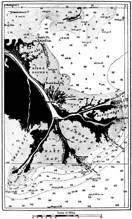
During high-water stages the Mississippi widely over-spreads its banks and during such inundations of its valley drops much of the silt it previously held in suspension. The material deposited is laid down most abundantly on the immediate border of its low-water channel. Each side of the channel is thus raised so as to form what is termed a natural levee. During this process also the bed of the stream is raised by the deposition of sediment upon it, thus tending to cause the stream to flow on a raised ridge and producing an unstable condition which from time to time enables the river to break across its confining levees and divide into two or more separate channels. In the lower portion of the river some of the new channels thus formed reach the sea and furnish independent outlets for its waters. The first of these distributaries now departs from the main channel at a distance of 200 miles from the Gulf of Mexico, and farther seaward several other divisions occur (Fig. 12). The area of the delta is about 1,230 square miles. Each distributary is engaged in building a pair of embankments, or natural levees (although this process in recent years has been modified by the construction of artificial embankments for the sake of improving navigation), and each subdivision of the river is also building a delta. Each of the finger-like extensions of the delta, shown on the accompanying map, is due to the prolongation of a pair of embankments into the Gulf by each distributary and the growth of a secondary delta at its mouth. The river is thus building a highly compound delta, composed of the secondary deltas formed at the mouth of each of its distributaries. A conspicuous modification of the otherwise generally evenly curved border of the Gulf of Mexico is thus produced, a result that could only be reached in a water body but little disturbed by wind or tidal currents.
ESTUARIES AND HARBOURS
The features of a coast of greatest importance to civilization are its harbours. A coast without harbours is like a Chinese wall, and tends to isolate a people inclosed by it. An indented coast with numerous havens for the shelter of vessels fosters the interests of navigation, including sea fisheries, invites commerce from other lands, and stimulates its inhabitants to explore and travel. A diversity of industries is thus favoured and the people adjacent to an indented coast with good harbours tend to become more progressive and more cosmopolitan than if intercourse with other communities is confined to overland routes.
The Atlantic border of North America is abundantly supplied with fine harbours, which not only favour communication with distant countries, but are within easy reach of agricultural and forest lands and important coal and other mineral deposits adjacent to the coast or in the interior, and are near extensive and valuable fishing grounds. The best of these harbours are at the mouths of rivers which have been depressed so as to form estuaries with wide entrances. These sea-gates, however, are frequently contracted, owing to the presence of sand-bars and spits deposited by shore currents.
The great St. Lawrence estuary reaches to Montreal, and beyond lie the Great Lakes, the rich lands of Ontario and New York, and the now highly productive States of the Middle West. Two geographical features in this basin detract from the conditions otherwise highly favourable to commercial development, namely: the rapids in the St. Lawrence between Montreal and Lake Ontario and the fall in the Niagara, and the winter climate of Canada, which causes the rivers and estuaries to be ice-bound for a considerable part of each year. To obviate the first of these unfavourable conditions far-reaching plans for a deep waterway between the Great Lakes and the Atlantic are now being matured. The splendid harbours from Nova Scotia southward are never seriously obstructed by ice, and south of Virginia ice is practically unknown.
The estuaries at the mouth of the Hudson, Delaware, Susquehanna, Potomac, James, and the Alabama, together with the distributaries of the Mississippi (which is not a partially drowned river, but one that is building up and extending its channel), are the natural outlets of portions of the continent of great fruitfulness. When other, and especially climatic, conditions are considered, it will be seen that to the geographer the Atlantic sea-border from the Gulf of St. Lawrence to the Gulf of Mexico seems destined to be the next great commercial centre in the succession from Greece to Britain. An important adjunct to the present highly favourable geographical conditions pointing to a great future for civilization on the Atlantic coast is the construction of a ship-canal across the isthmus uniting North and South America. This step must soon be taken.
A glance at a map of North America must impress one with the belief that the Pacific coast with its great extent of harbourless water-front is far less favourable to the growth or ideas, institutions, and industries than the deeply indented Atlantic shore-line. From the Isthmus of Panama to the State of Washington there is, as we have seen, but one harbour of the first class, the estuary of the Sacramento, and one of the second or third class, the estuary of the Columbia. From Puget Sound northward harbours are numberless. There are two important geographical reasons, however, why the general absence of good harbours to the south of Puget Sound is not so serious as it perhaps might seem. First, the mountain ranges run north and south parallel with the coast, and the natural lines of interior travel lead to the outlets through the Coast Ranges traversed by the Sacramento and the Columbia. The second and more general reason is that, owing to the warm currents in the Pacific, the portion of the west coast most favourable for a high degree of civilization is situated farther north than the similar belt on the Atlantic border.
By way of a summary of this chapter, the reader is asked to bear in mind the fact that the land forming North America, as is the case with all continents, is not at rest, but is subject to movements which cause elevations and depressions of various portions of its area with reference to sea-level. These movements have been in progress since the birth of the continent, and still continue. An upward movement of the earth's crust where the land and ocean meet causes a portion of the sea-floor to emerge and an addition usually of the nature of a coastal plain to be made to the border of a continent; while a reverse movement enables the sea to advance on the land and to flood the low-grade valleys opening to the ocean.
In a generalized view of the recent history of the coast-line of North America the dominant fact is that to the north of the latitude of the north shore of the Gulf of Mexico the resultant of the later movements of the continent is downward; the amount of the depression thus caused increases in a general way with increase in latitude on both the Atlantic and Pacific coasts. This downward movement has permitted the sea to encroach on the land and to flood many pre-existing valleys. On the Atlantic coast it produced such estuaries as Chesapeake and Delaware Bays, the tide-water portions of such rivers as the Hudson and the St. Lawrence, and farther north, where the submergence was greater, permitted the sea to invade the continental basin and form Hudson Bay. To this same wide-reaching cause is due also the bold ragged coast-line of the Atlantic from New England northward. On the Pacific border the downward movement is recorded by the tide-water portions of the Sacramento, Columbia, etc., and the deep picturesque fiords of the Canadian and Alaskan coasts. The most decided influence of these changes in the geography of the continent's margin on the affairs of men resulted from the production of numerous fine harbours and the extension of estuaries far inland, thus favouring commerce and fisheries in a high degree.
As a result of the oscillations just referred to, the sea has gained important characteristics as well as the land. The broad submerged shelf fringing the continent furnishes conditions highly favourable to both plant and animal life, and affords some of the most valuable fishing-banks of the world.
The Caribbean region is a marked exception to the broader changes that have affected the coast-line throughout the central and northern portions of the continent, and stands by itself as a conspicuous illustration of more localized earth movements which produced a remarkable submarine topography.
LITERATURE
In continuation of the studies outlined in this chapter the following books, most of which contain more special references, will be found of assistance:
Agassiz, A. Three Cruises of the Blake. 2 vols. Houghton, Mifflin & Co., Boston, 1888.
Gilbert, G. K. The Topographic Features of Lake Shores. In United States Geological Survey, Fifth Annual Report, 1883-'84, pp. 69-123.
Gulliver, F. P. Shoreline Topography. In Proceedings of the American Academy of Arts and Sciences, vol. xxxiv, 1899, pp. 151-258. Contains a valuable bibliography.
Hill, R. T. The Geological History of the Isthmus of Panama and Portions of Costa Rica. Bulletin of the Museum of Comparative Zoology at Harvard College, vol. xxviii, 1898, pp. 151-285.
Hill, R. T. Cuba and Porto Rico with the Other Islands of the West Indies. The Century Co., New York, 1899.
Shaler, N. S. Seacoast Swamps of the Eastern United States. In United States Geological Survey, Sixth Annual Report, 1884-'85, pp. 353-398.
Shaler, N. S. The Geological History of Harbors. In United States Geological Survey, Thirteenth Annual Report, Part II, 1891-'92, pp. 93-209.
Shaler, N. S. Sea and Land. Scribner, New York, 1894. United States Coast and Geodetic Survey. Annual Reports, Coast Pilot, Tide Tables, etc.
CHARTS AND MAPS
To the student of the geography of the coast and submerged border of North America, the extensive series of charts published by the United States Coast and Geodetic Survey supply a vast amount of accurate information. A catalogue of these charts, with prices, etc., is issued by the Survey. Many of the charts issued by the United States Hydrographic Office, and a large number of the topographic maps published by the United States Geological Survey, are of value in this same connection. An account of these charts and maps, with instructions as to methods of obtaining them, etc., is given in Government Maps for Use in Schools, by Messrs. Davis, King, and Collie, published by H. Holt & Co., New York, 1894.