Chapter II · (continued 2)
Reading edition
El Llano Estacado, or the Llano, as it is frequently termed, is about 500 miles across from north to south, and 280 miles wide from east to west. It is bordered on nearly all portions of its periphery by descending escarpments which lead down to the adjacent valleys. Its surface, although appearing horizontal, in reality slopes eastward at the rate of about 20 feet per mile, and on its highest, northwest border, has an elevation of 5,500 feet above the sea. This great table-land has a smooth floor, and, as reported by recent explorers, is clothed with an abundance of bunch-grass, which formerly furnished sustenance to herds of antelope and deer. It was in this general region also that some of the immense herds of buffalo which once inhabited the broad plateaus found a winter range.
The Llano, together with its southward extension, having the same characteristics and known as the Edwards plateau, is bordered on the west by the deep and broad valley of the southward-flowing Pecos River, and on the north by the equally deep and broad valley carved in the plateau country by the eastward-flowing Canadian River. The eastward slope of the surfaces of the two plateaus is continued throughout the region bordering them on the east all the way to the shore of the Gulf of Mexico. The streams originating on the eastern border of the eastward sloping plateaus and flowing to the Gulf of Mexico, represented at the present time by the Colorado (of Texas), the Brazos, Trinity, and Red Rivers, extended their trunks by head-water corrasion and developed numerous branches so long as the rainfall was sufficient to maintain a surface drainage. But as the streams were lengthened they cut farther and farther westward and into a region that became drier and drier, until finally they reached a land in which all of the scanty rain that fell was absorbed by the thirsty soil. The drainage from this higher and drier region is subterranean, and reaches the head waters of the streams to the eastward to a considerable extent as springs. The streams which lowered the country to the eastward of the Llano developed many branches, some of which were extended westward into the drier plateau country in such a manner as to give the eastern margin of the remaining upland a scalloped and irregular border.
In travelling westward up the courses of the rivers of eastern Texas, one passes from a low region of old topography to one where the head branches of the streams flow in cañons, and the relief has the ruggedness of youth; on gaining the western border of the belt of country having surface streams one ascends to the smooth surface of the high plateau, which is young as regards stream development, although in years older than the country with a deeply eroded surface to the eastward. The Llano and Edwards plateau present us with examples of perpetuated topographic youthfulness.
The Llano, although dreaded by early explorers and shunned so far as possible even by experienced plainsmen, on account of a lack of water, has in recent years become more favourably known. It is crossed at present by two railroads. Water has been found beneath the surface in numerous localities, and the desert-like region now bids fair to become a favourable cattle-raising country. It is not to be expected, however, that all the glowing predictions which have been published concerning this and neighbouring table-lands will be more than partially fulfilled through the use of the subsurface waters.
The Arkansas Plateau.—To the north of the Canadian River the region termed above the Great plateaus is less deeply dissected than in the portion of which the Llano is typical, and the streams from the mountains flow through shallow valleys with less rugged and less picturesque borders than those of the deep wide valleys of western Texas and eastern New Mexico. The broad plateau surfaces adjacent to the valleys of the Arkansas and Platte Rivers probably come nearer to the popular idea of the essential characteristics of the "Great plains" than any other of the larger divisions of the region under review. The most conspicuous geographic features of the Arkansas plateau have been described by W. D. Johnson as consisting of an assemblage of low and broad table-lands separated by shallow erosion valleys. The plateaus are immense unsculptured remnants in light relief of an older and originally perfect plain. The few long and feeble streams, wide apart and flowing eastward from the distant mountains in parallel courses and without tributaries, have blocked out by dissection the larger features of the broad landscape which in future ages will be slowly etched into a multitude of details. The scenery of these featureless plains is ordinarily depressing when once the novelty of being adrift on a sea of grass has passed away. There is nothing that can be termed scenery except that which once a year for a brief period the sky affords when clouds of extraordinary grandeur darken the air. Throughout nearly the entire annual course there is no material for landscape effect except the straight line of the horizon with a featureless breadth of sun-faded brown below it and above a merely broader space of faded blue. There is nowhere a curved line, and though as a scientific fact there is vast expanse of flat plain, there is little to suggest it when the sky is empty of clouds. In June the clouds come with a gradual maturing at some point along the even sky-line, and increase rapidly until the heavens are filled with magnificent vapour banks; but the display is simply spectacular, and passes away in a few hours as quickly as it came, with only local showers to refresh the land.
The one industry that can thrive on the Arkansas plateau, which was formerly at certain seasons blackened by herds of bison, is stock-raising. Wells from which water is pumped by windmills furnish sufficient water for herds of cattle and horses, but not for irrigation.
Bad Lands.—In the northern portion of the Great plateaus within the United States the surface rocks over great areas are soft or but irregularly hardened sediments of ancient lakes and streams and have been sculptured by rain, wind, and ephemeral rills into a most marvellous array of monumental and castellated forms. Localities where this minute dissection of the soft horizontal strata is especially well marked over hundreds of square miles occur in South Dakota and Montana, and especially on the borders of the valleys carved by the Loup Fork, Niobrara, White, Yellowstone, and Missouri Rivers. In this region the rainfall is light, the mean annual precipitation being in the neighbourhood of 15 inches, and occurs mostly during the winter months. In the summer season the lands far out on the plateaus are dry and hot, and all but the larger streams disappear. The rocks, consisting mostly of unconsolidated clays and soft sandstones, with occasional hard layers and irregular concretions, have been cut into innumerable channels, leaving steep-sided remnants of the former plain between. The maze of trench-like valleys, the similarity of the sculptured land-forms one to another, and the absence of water, make these desert regions excessively difficult to traverse. The Canadian-French who explored the north-central portion of the Great plateaus in early days of American settlement termed these tracts of country, so difficult to cross, Mauvaises Terres, a name now seldom used, but replaced by the English name Bad Lands. Although bad to the hunter and the plainsman, these desert regions are of fascinating interest to men of scientific training. The intense heat, the choking alkaline dust, the absence of water, and the danger of being lost and of perishing of thirst in these wild silent regions, have not checked the ardour of explorers. Not only do the Bad Lands present a most attractive field to the student of erosion and of the origin of earth forms, but their deathlike solitudes have been made to yield the most wonderful procession of strange extinct animals yet unearthed by geologists. They are vast cemeteries in which are interred the skeletons of many genera and hundreds of species of animals which lived in the ancient lakes or wandered through the almost tropical forest that in distant ages clothed the adjacent country. The great lesson to be learned by the geographer in these uninviting regions as they seem to most people relates to the way in which the rocks have been eroded. The prevailing softness of the beds with occasional hard layers, the scarcity of vegetation, the occasional heavy rains, and the considerable height of the country above the master streams combine to favour rapid and deep sculpturing. The precipitous slopes of the small mesas and castle-like rock forms destitute of all vegetation excepting succulent cacti and scattered clumps of bunch-grass, reveal a multitude of sunken lines and raised edges, produced by the ephemeral streams, and a less complex series of horizontal ledges due to the prominent edges of hard layers. The steep slopes are worn into alcoves and irregular recesses by the transient rills, and smoothed or etched by the wind-driven sands. The result is an assemblage of architectural forms such as only the most fantastic dream pictures or the strange tricks of the mirage on northern ice-fields can simulate. Nor are the wonderfully intricate topographical forms the sole attraction. The rocks are variously coloured, and present endless combinations of yellow, red, green, purple, etc., in many tints and shades, rendered seemingly brilliant by contrast with the gray of shales and the blackness of occasional coal-seams. Owing to the burning of coal-beds, the rocks are sometimes altered over broad areas and given unusually striking colours, among which various shades of red predominate. Standing on some commanding crag in the Bad Lands in the early morning or when the purple shadows of evening fill the gorges and ravines, the most unimaginative traveller sees in the silence about him the ruins of a vast city, with cathedrals, temples, and palaces of varied colours and weird designs such as no mortal hand ever fashioned. It is at such times that the picturesque and gorgeous, although desolate, landscape kindles the fancy and suggests day dreams which distract one's attention from the more prosaic study of these earth ruins.
The best developed portions of the strange region here referred to occur on the borders of the uplands overlooking the larger valleys, excavated by the rivers flowing eastward from the mountains, and are simply larger examples of erosion, such as may be seen in many bluffs and valley-sides in nearly every country, but rendered conspicuous by their size, extent, endless variety, and unusual colours.
Sand-Hills.—The sands winnowed by the winds from the bare plains and steep bluffs are in certain places on the Great plateaus gathered into dunes which cover great areas with a succession of low dome-shaped hills. On the borders of the Niobrara River there is a detached area of about 20,000 square miles, which has been covered in this manner with loose sands. This region, as described by F. V. Hayden, presents a succession of round-topped hills, some of them scooped out by the swirling winds so as to resemble volcanic craters. These sand-hills were formerly a favourite resort of the bison, which fed upon the scanty but very nutritious grasses in the little valleys and intervals among the mounds and ridges. There is, for the most part, an abundant supply of water in the lakelets scattered through the region, and fed by the seepage from the porous sands, which drink in all the water that falls upon them and allow it to percolate slowly into the adjacent depressions. Some of the lakelets and ponds are highly alkaline, while others are fresh; the former can be easily distinguished from the latter by the absence of vegetation about their borders. The hills, although seemingly utterly desolate, on a nearer view sometimes reveal considerable vegetation, including yuccas or "Spanish needles," which shelter the sands from the winds.
Many other regions on the western border of the Great plateaus, in the valleys of the Rocky Mountains and on the desert plains of Utah, Nevada, and California, are buried beneath drifting sands, which have the characteristic features of a dune-covered seacoast. The sources of the sands in these interior plains are usually to be found in the disintegration of the rocks under the action of the dry air with its many and sudden changes of temperature, but occasionally they come from desiccated lake beds not yet clothed with vegetation.
Central Portion of the Great Plateaus.—The State of Nebraska, about 400 miles in length from east to west, and extending across the Great plateaus to within some 60 miles of the mountains bordering them on the west, furnishes a typical example of the west-central portion of the interior Continental basin. As described by Hayden, this State may be divided into two portions, one agricultural and the other pastoral. The eastern part, included in the Prairie plains, contains some of the most beautiful, gently rolling, and fertile agricultural lands in America. But the western part is a treeless, almost waterless plain; yet thick, low, sweet, nutritious grasses cover the entire surface, and render it well adapted for the raising of large numbers of horses, cattle, and sheep. Over western Nebraska not more than 15 or 20 inches of moisture fall annually; the snows of winter are very light and soon pass away, the winds rapidly gathering them into the valleys and gorges, leaving vast areas entirely bare. The grasses, instead of decaying, as in all temperate countries with a humid climate, slowly wither, retaining all their nutritious qualities, and thus continue until April or May, when the fresh shoots spring up, so that all kinds of stock thrive throughout the winter on the open plains without artificial shelter. In this account, however, the author cited fails to note that the winters are frequently marked by exceedingly severe storms termed blizzards, during which gales blow while the temperature is far below freezing, and that at such times cattle have been known to perish by thousands.
In late summer and autumn the streams in this portion of the plateau region for the most part become dry, although water may usually be discovered at long intervals in pools in their beds. In ascending the valleys the water appears and disappears as if by magic. Here one finds a swift-running stream several yards broad, and then for a considerable distance nothing is to be seen but a dry and dusty creek bed, resembling a sunken roadway. Even the broad Platte has so far forgotten itself for several seasons as to cease to be a running stream. It is not uncommon for a river originating in the mountains on the west to be considerably larger towards its source than near its mouth. Many of the important streams that flow from the Black Hills towards the Missouri are lost on their way through the plains. The Yellowstone and the Missouri, the two most important rivers crossing the Great plateaus in the northern portion of the United States, retain their existence throughout the year, although becoming greatly shrunken in autumn, and send eastward a never-ceasing tribute to the Mississippi.
Northern Extension of the Great Plateaus.—The Great plateaus cross the United States-Canadian boundary and extend northwestward through the western portion of Assiniboia and Saskatchewan, and embrace nearly the whole of Alberta and western Athabasca. At the international boundary the plateau region is about 470 miles broad, and extends from longitude 103° 30' westward to the foot-hills of the Rocky Mountains, and in this region embraces what is frequently termed the third prairie steppe, known in part as the Missouri Coteau. The east border of this high plateau throughout much of its extent is well marked by an escarpment which descends some 300 or 400 feet to the second prairie steppe, which together with the first or most easterly of the series, embracing the Red River Valley, is usually considered as belonging to the Prairie plains. The third steppe in the series, or the one extending from the Red River to the Rocky Mountains, has an elevation along its eastern border of about 2,000 feet, rises gradually to the westward, and attains a general elevation of over 4,000 feet on its western border. All of the region of the Great plateaus north of the international boundary, with the exception of about 20,000 square miles tributary to the Missouri, is drained by rivers flowing eastward to Hudson Bay or northward to the Arctic Ocean. It is thus a portion of the northern or arctic slope of the Continental basin. The eastern border of the plateau country trends northwestward, and finally reaches the Rocky Mountains in the vicinity of the head waters of the Mackenzie, but as this region is but imperfectly explored, our knowledge of the boundaries of the natural division of the continent we have been endeavouring to trace there becomes indefinite. The Great plateaus in Canada merge into the Prairie plains bordering them on the east, and in large part the position of the dividing line between the two is arbitrary.
The portion of the Great plateaus in Canada, like the similar region to the south, is covered with bunch-grass, which dries as it stands and forms highly nutritious self-cured hay. Formerly this region was the winter feeding-ground for vast herds of bison. The winters, although cold, are not characterized by a heavy snowfall, and even in midwinter the warm dry chinook winds, as they are termed, similar to the foehn winds of Switzerland, frequently cause the snow to disappear and leave the brown plateau surfaces free for grazing. Now that the bison has disappeared, this immense region is favourable in many ways for stock-raising, but, unlike the lower prairies to the east with their rich black soil and long hot summers, is not suitable for agriculture. The main difficulties in the way of successful farming lie in the dryness of the summers, and the scarcity of water available for irrigation. The rivers flow in valleys several hundred feet below the general plateau surfaces, and hence cannot be made available for irrigating the uplands without too great an expense. In the bottoms of the valleys, however, adjacent to the stream, limited areas are now under cultivation, and it is to be expected that the wheat-fields of the prairie region will be gradually extended into the valley to the westward, and perhaps even to the eastern margin of the plateaus. A greater extension of the wheat-belt to the north and west than is now thought practicable has been predicted, but what the ultimate limit will be cannot be told.
The Black Hills of Dakota.—As stated in the brief account already given of the Prairie plains, their monotony of surface and of geological structure is broken by a single area of disturbance termed the Ozark uplift. Similarly, the vast generally level expanse of the Great plateaus is broken by a single rudely circular region of elevation, the Black Hills of Dakota, which has been sculptured by atmospheric agencies and given a diversified topography, in striking contrast with the even monotony of the country surrounding it.
This protuberance on the surface of the Great plateaus is situated in the southwest portion of South Dakota, and embraces also a part of Wyoming, and about 140 miles east of the nearest range—the Big Horn Mountains—of the Rocky Mountain chain. It rises from the surrounding plateau to a height on an average of about 2,000 to 2,500 feet; the highest summit, Harney Peak, is 3,000 feet above the plain, and 7,216 feet above the sea. The uplift is elliptical in ground plan, with a northwest and southeast axis measuring about 120 miles, and a transverse diameter of 40 to 50 miles. Its area is in the neighbourhood of 6,000 square miles.
While the generally level plateau surface about the Black Hills is treeless, except for the scattered groves of wide-spreading cottonwoods along the immediate banks of the larger streams, the central and higher portions of the elevation itself is clothed with an open but abundant forest, consisting principally of pines. The evergreen forests give to the hills a nearly black colour when seen from a distance, and have gained for them the name they bear.
The rocks which have been forced upward so as to form the Black Hills dome were previously like those in the surrounding plain, quite horizontal, and had a vertical thickness of at least 5,000 feet. The uplift, if uneroded, would rise from the surrounding plain as a flat-topped dome about 6,600 feet high, as is suggested by the highest dotted line in the following diagram. In reality such a dome never existed, for the reason that its growth was slow, and perhaps is not completed even at the present day, and as soon as the rocks began to rise, the rain, wind, streams, etc., commenced their task of destruction. The higher the rocks were elevated the more powerfully those agencies acted. The top of the dome was soon broken and its internal structure revealed.
Fig. 18.—Ideal east-and-west section through the Black Hills. The vertical scale is about six times the horizontal. The dotted lines indicate the portion of the uplift removed by erosion. After Henry Newton. 1. Archean slates and schists. 2. Granite. 3. Potsdam, sandstone, resting unconformably on 1 and 2. 4. Carboniferous, mostly limestone. 5. Red Beds (Trias), sandstone with included limestone. 6. Jura, shales. 7. Cretaceous, shales. 8. White River Tertiary, shales, resting unconformably on 7.
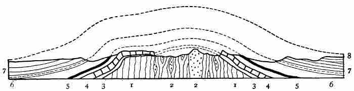
By reference to the accompanying generalized section through the Black Hills, which as the uplift is rudely circular would be essentially the same if taken in any direction through the elevated region, it will be seen that there is a central core of slate, schists, and granite which has been forced upward so as to stand in its present eroded condition; it rises well above the surface of the adjacent plateau. About this central core the upturned edges of the sedimentary rocks form concentric zones, the oldest in the series being next the schists, and the youngest 10 to 40 or 50 miles distant. It is the presence in the central part of the hills of an area of resistant crystalline rocks which have weathered into rugged forms, and the series of encircling and concentric belts of rock of varying degrees of hardness and solubility, that has given to the uplift its present peculiar relief and its generally beautiful scenery. The edges of the harder belts form bold hills and ridges, while the softer belts have been eroded into valleys. This series of sharp-crested ridges and intervening valleys forms concentric circles completely surrounding the central group of rugged mountains. The largest and most interesting of the ring-like valleys is underlaid by red sandstone, and is remarkable for its flaming colour as well as for its exceptional form. In this Red Valley one may ride entirely around the rugged central mass of the hills, on a generally level surface, which is inclosed on its outer border by a precipitous wall of yellowish sandstone and shale 300 or 400 feet high. The distance about this "race-course," as it is sometimes termed, is about 200 miles. This series of concentric ridges and intervening valleys, surrounding a high and rugged region of more resistant rock, furnish an admirable illustration of the influence of rock texture, hardness, etc., on topography.
Another instructive geographical lesson afforded by the Black Hills is the manner in which the portion of the dome rising above the level of the rivers which flow across the surrounding plain has been dissected by stream erosion. The streams originating in the central portion of the uplift flowed outward in all directions, and have cut deep narrow gorges through the ridges of hard rock in the base of the truncated dome. Some 20 streams originating in the central portion of the uplift cross Red Valley and escape through notches in its outer wall, about 16 of which are well-defined gateways leading to the encircling plateau. This is one of the most beautiful and most instructive examples of consequent drainage—that is, of streams whose direction has been determined by the inclination of the surface over which they flow—thus far discovered. Still another feature of much geographical interest is furnished by the rivers on the adjacent plain, two of which, branches of the Cheyenne River, cross the north and south extensions, respectively, of the Black Hills dome. These streams flow directly across the arched strata, in cañons of their own making, and, as explained by G. K. Gilbert, are illustrations of superimposed drainage—that is, the portions of the dome crossed by the branches of the Cheyenne after the rocks were upheaved were covered by soft horizontal lake beds, over which the water flowed as consequent streams. The rivers deepened their channels and cut through the soft cover of horizontal rock and into the arched beds beneath. The course of the streams initiated on the covering of soft beds were maintained, as the flowing water charged with sand cut downward into the harder, upturned beds beneath, and now, the covering of soft beds having been eroded away, the rivers flow directly across (or through) the flanks of the great arch, but are not deflected by it.
In the neighbourhood of the Black Hills, and especially about their northern and northwestern border, there are secondary hills formed by the upward protrusion of molten rocks into the generally horizontally stratified rocks underlying the plateau. These intrusions did not reach the surface in such a way as to form volcanoes, but were forced upward, raising domes above them, in which the structure is similar to that in the great Black Hills dome. These secondary domes have been eaten away by erosive agencies in varying degrees. In some of them, as the Little Sundance Hill, near the town of Sundance, Wyoming, the dome of stratified rock is unbroken, and no igneous rock is to be seen; other neighbouring domes in which the plutonic magmas rose higher have been eroded so as to expose the summit portion of the inner core; and in one instance, known as Mato Tepee, the uncovering of the plug of plutonic rock which caused the uplift is so complete that it now forms a prominent fluted column over 600 feet high above its immediate base.
Volcanic Mountains and Table-Lands.—In the south-central portion of the Great plateaus in southwestern Colorado and eastern New Mexico, there are several typical cinder cones with lava-flows associated with them, which impart novel topographic forms to the general monotony of the broad plateau surfaces. The highest of the extinct volcanoes in this region is Mount Capulin, situated in northeastern New Mexico, about 200 miles east of the Rocky Mountains, which rises 2,750 feet above the surrounding plain, and has an elevation of about 9,000 feet above the sea. At the summit of this conical mass there is a well-defined crater a mile in diameter. In the same region there are several other similar volcanic cones, from which lava streams have descended. As has been pointed out by R. T. Hill, these are the most easterly volcanoes of recent geological age in North America. They were formed after the Tertiary rocks of the Llano were laid down.
The Raton Mesa, situated between Mount Capulin and the front range of the Rockies, is capped by a lava flow of more ancient date than the volcanoes just referred to, which has protected the softer rocks beneath from erosion, and now stands as a prominent table-land with precipitous borders.
THE PACIFIC MOUNTAINS
To the west of the Continental basin is a vast cordillera composed of numerous mountain chains which extends from south-central Mexico northward to the Arctic Ocean, and in its broadest part is about 1,000 miles wide. As already explained, we speak of this region in its entirety as the Pacific cordillera, or less technically as the Pacific mountains. It is a highly complex group of mountain chains, each of which contains two or more distinct mountain systems; each system, again, is usually composed of many ranges, and each range is frequently made up of a multitude of ridges, peaks, buttes, mesas, etc.; there are also many plateaus more or less completely dissected by erosion, and broad valleys, as well as numerous cañons, gulches, ravines, arroyas, and other secondary topographic forms. This vast cordillera not only contains mountains produced by the folding of the rocks of the earth's crust, in a general way similar to the Appalachians in structure, but also upturned blocks many miles in extent, bounded by breaks or faults, and volcanic mountains, vast lava-flows, and elevations due to the injection of molten rock into the earth's crusts so as to elevate domes. In fact, scarcely any topographic form and no important geological structure that is known is lacking in this great family of mountains which dominates the western portion of the continent.
The Pacific mountains begin abruptly at the south, along a generally east and west line passing some 75 miles south of the City of Mexico, where the precipitous border of the table-land of central Mexico overlooks a lower region to the south which is diversified by many volcanic mountains. But little accurate information is available concerning the geology and geography of Mexico, but in general, as is well known, there are three main mountain belts which traverse that republic. One of these mountain belts is adjacent to the Gulf of Mexico, and another is situated near the Pacific coast of the main portion of the republic, while the third forms the rugged and irregular axis of the peninsula of Lower California. Between the leading mountain belts of the mainland there are numerous short ranges and many nearly level-floored valleys. The general level of this inland region is in the neighbourhood of 6,000 feet, while the more prominent peaks and crests attain elevations of from 10,000 to 12,000 feet. The general trend of the main mountain belts, and of the numerous subordinate ranges, is about northwest and southeast. For this reason, and also because the valleys have become deeply filled with débris from the mountains, travelling in directions leading north and south is facilitated by the topography, while in passing from one coast of the republic to the other the rugged bordering mountain belts have to be crossed and detours made in order to pass around the central mountain ranges.
The more elevated portion of central and northern Mexico, together with the peninsula of Lower California, has an arid climate, to which many of the conspicuous features in the geography of the land are due. The precipitation over large areas is insufficient to maintain permanent streams, the vegetation is nearly all of a desert-like character, and several basins exist which do not drain to the sea. In the interior basins there are saline and alkaline lakes, and numerous dry lake beds or playas, which are whitened by saline efflorescences. The rocks exposed in the mountains are largely of sedimentary origin, but a characteristic feature is the geology, especially to the west, in the presence of extensive volcanic areas and lofty mountains of igneous rocks.
The Pacific cordillera begins in southern Mexico with a width of some 300 miles and broadens when traced northward. At the boundary between Mexico and the United States it has a width of fully 700 miles, but reaches its greatest breadth in the latitude of San Francisco and Denver, where it is about 1,000 miles across. In its better known, but as yet incompletely studied portion embraced within the boundaries of the United States there are several important subdivisions, such as the Rocky Mountain belt on the east; a less lofty, but yet rugged central region, termed the Great Basin, characterized by having a dry climate and by the fact that the streams do not reach the ocean; and a western mountain chain which includes the Sierra Nevada and Cascade Ranges. To the west of the mountains just named lies the great valley of California, and similar regions in Oregon and Washington occupied in part by Puget Sound. To the west, again, are the several ranges bordering the Pacific coast from Lower California to Vancouver Island, and termed in a general way the coast mountains. Each of the great divisions of the Pacific mountain region has its indefinitely known southern terminus in Mexico, and extends northward to beyond the Canadian boundary. As this central portion of the most westerly of the larger geographical divisions of the continent is well developed in the United States, and has there been more carefully explored than elsewhere, a review of its leading features will serve to give as good an idea of the entire Pacific mountain region as is now practicable.
The Rocky Mountains.—The limitations to the north and south of the region to which this name is more or less specifically applied are not well defined. Perhaps the most accurate statement at present permissible is that the Rocky Mountains begin at the south, in northern Mexico, and extend northward across the United States and Canada to near the shore of the Arctic Ocean. On the east it is sharply defined by its junction with the Great plateaus. Its western border, although less definite than the eastern, is easily traced, at least across the greater portion of the United States, by the marked contrast it presents to the geographical conditions characteristic of the Great Basin region, but owing to the many difficulties met with in attempting to adjust and make use of the current nomenclature in classifying geographical regions more or less artificial boundaries have to be accepted. The Great Basin is so designated because it is a region of interior drainage—that is, it does not send any tribute to the sea. Its boundaries are therefore the crest-lines of the surrounding divides or water-partings. The Rocky Mountains, on the other hand, are defined as an elevated region, the boundaries of which are determined by relief and not by drainage. The basis of classification in these two instances is not the same, and one province overlaps the other. The streams flowing westward from the Rocky Mountains into the Great Basin—such, for example, as Bear, Provo, and Sevier Rivers in Utah—have their sources well within the Rocky Mountain province as defined by uplift, but yet lie wholly within the Great Basin province as defined by drainage. In spite of this inconsistency, geographers recognise as the western border of the Rocky Mountains the irregular and in part indefinite line where the elevated region breaks down and meets the broad level-floored valleys characteristic of the Great Basin. This line, or more properly belt of country, although indefinite at the south, may for convenience be taken as beginning at the head of the Gulf of California, and extending up the Colorado River for about 300 miles, to where that river makes an abrupt bend, turning southward after a westerly course through the Grand Cañon. From the locality indicated, the boundary passes through central Utah, and is sharply defined for most of the way by the bold western escarpment of the Wasatch Range. In the neighbourhood of Great Salt Lake the border of the mountain belt trends more and more to the northwest, crosses Idaho diagonally, and in northern Washington merges with or closely approaches the Cascade Mountains. In this northern region the border of the Rocky Mountains is again indefinite, and until the geological structure of western Canada is more thoroughly studied can only be located provisionally.
The unsatisfactory condition of the nomenclature at present applied to the larger topographic features of North America is illustrated by the fact that to the north of the United States-Canadian boundary the term Rocky Mountains is much more restricted than is the custom in the United States. In Canada this name is applied to the most easterly of the ranges or chains of the Pacific cordillera. This difference in the significance of the name referred to on the opposite sides of the international boundary is unfortunate, but is due in large part to our ignorance of the geography and geology not only immediately along the boundary line, but generally throughout the rugged region of the northwest portion of the continent.
One of the most important geographic features in the central part of the United States is the presence in Wyoming of a broad, generally flat, region known as the Laramie plateau (plains) and its extension westward across nearly the entire width of the Rocky Mountains. The general elevation of these "plains" is about 7,000 feet, or approximately 1,000 feet greater than that of the western border of the Great plateaus. The Laramie plateau and country to the west having a similar topography, furnished a convenient pass for the Union Pacific, the oldest of the transcontinental railroads, and divides the Rocky Mountain belt into two portions, which may be termed in a general way the northern and southern Rocky Mountains respectively.
To the north of the Union Pacific Railroad there are several important mountain groups, termed collectively the Stony Mountains by Lewis and Clark in the report of their bold explorations across the continent in 1804, but not generally used since that time. This name has recently been revived by J. W. Powell as a convenient term by which to designate this large division of the Rocky Mountain belt, but unfortunately is not recognised and has no significance to the north of the international boundary. What the natural limitations of the Stony Mountains may be in Canada remains to be determined.
The Stony Mountain system includes the Big Horn Mountains in north-central Wyoming, the sharp and lofty Teton Range to the south of the Yellowstone National Park, and several other rugged uplifts of great extent in Montana and Idaho, and should the name be extended to the north of the international boundary until a natural limit is reached, it will include the Rocky Mountains of Canadian geographers (the most eastern of the great uplifts constituting the Rocky Mountain belt), together with the several ranges of the Gold Mountains. These several mountain ranges and groups of ranges appear to have diverse geological structure, but their histories are by no means thoroughly understood. Some of them, as stated by Powell, are carved out of broad folds, and involve both originally deeply seated igneous and metamorphic rocks and upturned and folded sedimentary beds; while others are due to movements along lines of fracture and in part of overthrust.
The Stony Mountains form a portion of the continental divide which parts the waters flowing to the Pacific from those that find their way to the Atlantic. The thousands of streams tributary to the Missouri head against the equally numerous fountains supplying the westward-flowing Columbia. The broad valleys between the several ranges have a general elevation of between 7,000 and 8,000 feet, and the bold, massive mountains rise from 10,000 to over 13,000 feet above the sea. Owing to the considerable elevation even of the valleys, and the northern position of the region here considered, as well as its distance from the equalizing influence of the sea, the extremes of climate are strongly marked. The summer season is comparatively short, and in the valleys the heat is intense (ranging from 90° to 112° F.) and the rainfall small or none at all, while the winter season is cold (temperatures of from -15° to -30° F. being frequent) and accompanied by an abundant snowfall, especially on the mountains. Agriculture, although carried on in the valleys, is of comparatively small importance, and is usually dependent on irrigation. The mountains are snow-covered through much of the year, and small glaciers occur about the lofty summits of the Teton Range and on the mountains near the international boundary and in Canada. The valleys are generally destitute of trees except along the streams, where white-trunked cottonwoods spread their green leaves in summer and become a tracery of golden yellow in the autumn, marking the courses of the life-giving waters. The lower mountain slopes are covered with dark forests of pine, spruce, and juniper, which increase in density and extent as one follows the ranges northward until the influence of the high northern latitude is felt, and in northern Canada the zone of the subarctic forest is reached.
In the central part of the Stony Mountains is situated the justly famed Yellowstone National Park, which is truly remarkable for its fine scenery, its deeply carved and gorgeously colored cañons, and most of all for its numerous hot springs and spouting geysers. This is the only geyser region on the continent, and the most extensive of the three now existing in the world.
The finest scenery of the northern division of the Rocky Mountain belt lies to the north of the international boundary, and within recent years has been rendered accessible by the building of the Canadian Pacific Railroad. It is in this region that the mountains are highest, most rugged, and clothed most completely with the dark, sombre, evergreen northern forests. Here, too, high up among the bare serrate mountain tops, and mostly above the timber-line, are found the largest of the glaciers in the Rocky Mountain belt. This wonderful region of rugged mountains, deep and formerly glacier-filled valleys, impetuous rivers, and dense forests has only recently become known to the world at large. Vast areas, no doubt as attractive as those about Banff, Lake Louise, Glacier House, etc., already famous, remain to be discovered and described.
In the fastnesses of these wild northern Rockies moose, elk, deer, bear, mountain-sheep, and mountain-goat still abound. The buffalo (bison) is protected in the Yellowstone National Park, and will probably be preserved from extinction. A small herd also survives in Canada. The streams, except those flowing from glaciers, are bright, clear, and swift, and are well stocked with fish. The trout, represented by several species, there finds the cool retreats so essential to its life. To the sportsman and skilled angler the northern Rockies are a paradise. Among the lofty mountains and in the larger valleys there are many lakes, more especially in northern Idaho and Montana and in Canada. Many of these, and particularly those near the heads of the valleys and about the more lofty peaks, are true rock-basin lakes, worn out by the grinding of sand-charged glacial ice when the glaciers were far more extensive than now. The large lakes situated in the trunk portions of the broad-bottomed valleys are in many instances retained by dams of glacially deposited detritus and record the changes in the aspect of the land inherited from the Glacial epoch. These numerous lakes present a vast variety of scenery, and in many instances reflect from their placid mirror-like surfaces as beautiful and inspiring pictures of rugged grandeur as can be found in the world. The natural beauties of the classical lakes of Switzerland and Italy are rivalled by many of the charming water bodies of the northern Rockies, which but few men appreciative of the beauties of nature have ever seen.
To the south of the Laramie plateau the mountains of the Rocky Mountain system are more irregular and more lofty than those to the north of that break. The many rugged ranges in southern Wyoming, Colorado, and northern New Mexico form a great group, to which the name Park Mountains has been applied by J. W. Powell. The several ranges composing this group have a general north and south trend, to which, however, an exception is furnished by the Uintah Mountains in southwestern Wyoming and eastern Utah, which consists of a deeply dissected east and west fold or broadly uplifted plateau. Intervening between several of the adjacent ranges there are wide, nearly flat-bottomed valleys, which owe their leading characteristics to the deep filling of depressions by débris carried from the bordering mountains by the wind and streams. These broad valleys surrounded by rugged peaks are known as parks, and the numerous ranges among which they are situated are hence designated the Park Mountains. The term by which the valleys are known is in some respects misleading, as the word park usually carries the idea of a diversified and in part forested region, with mild, picturesque scenery. Perhaps a city park or the beautiful rural estates of England are most usually brought to mind when the term referred to is mentioned. But in the great mountains of the central portion of the continent one's idea must expand to keep in harmony with his surroundings. The natural parks of that region are broad, generally treeless, valleys with winding streams, the uplands are grass-covered and rolling, and in distant views the courses of the streams are marked by narrow belts of verdure. The picture is framed by a succession of mountain domes and embattled cliffs. Over all arches the dark blue, cloudless sky of a nearly rainless region. In the clear air distances are deceptive, and what appear to be miles to the novice must be extended to leagues in order to acquire adequate conceptions of the magnitude of the scene.
The most famous of the great tracts of generally level land surrounded by the high ranges of the Park Mountains is San Luis Park, situated in southeastern Colorado and extending southward into New Mexico, which has a length from north to south of about 130 miles, and is from 20 to nearly 40 miles wide. Its general elevation is between 7,000 and 8,000 feet. This great valley, level-floored with soft deposits swept in from the bordering highlands, and almost completely surrounded by rugged mountains, although more desolate than the majority of the numerous similar valleys in the same region, is typical of its class. The Rio Grande winds through its entire length and many streams rising in the bordering mountains flow to the valley during the winter season, but in summer, owing to the high temperature, active evaporation, and small rainfall, only a few of the larger of these mountain-born torrents reach the main, southward-flowing river. In the southern portions of the valley large areas are covered with drifting sand, which is fashioned by the winds into ever-changing dunes of a creamy whiteness. Some of the streams from the mountains expand on the plain and form the San Luis lakes, from which the water escapes by evaporation, thus causing them to become alkaline. The land bordering the lakes is whitened as with snow by saline incrustations. On the lower portion of the rim of this mountain-inclosed basin there are scattered groves of pines and junipers, and at higher elevations the mountains are dark with forests. The more lofty peaks, however, rise far above the upper limit of the forests and are rugged and magnificent even under the glare of a cloudless sky.
To the east of the San Luis Park, and rising about 7,000 feet over it, and over 14,000 feet above the sea, stands Sierra Blanca, one of the finest of the many majestic mountains of Colorado. In summer immense cloud banks frequently gather about this cold, isolated peak, and local storms, accompanied by fierce lightning and echoing thunder, beat upon its shrouded sides. These tempests raging on the mountain top, while the adjacent valleys are flooded with sunlight, recall the scriptural accounts of the storms of Mount Sinai. In fact, the southwestern portion of the United States and the adjacent region in Mexico, so far as scenery and climatic peculiarities are concerned, have much in common with Palestine.
The other great parks in Colorado, which have suggested a name for the group of mountains in the midst of which they are sheltered, are less arid and less desert-like than the one just described; but like it, derive their magnificence and fascination from their vast extent, the sublimity of the bordering mountains, and the wonderful transparency of the air above them, rather than from the topography of their nearly level floors or the vegetation that strives ineffectually to clothe their nakedness.
The individual summits as well as the separate ranges composing the Park Mountains are remarkable for their massiveness and the great height of their bare rounded summits rather than for picturesque details. Several of the peaks are among the highest in the United States. One conspicuous feature is the considerable elevation of the valleys, usually over 7,000 feet, and the large number of lofty summits. Of the peaks that have been measured, over 30 exceed 14,000 feet in height. The portion of the Park Mountains above an elevation of 10,000 feet, as is indicated on the map reproduced on page 65, is far greater in area than any other region of similar altitude on the continent.
In the Park Mountains, and generally throughout the southern Rockies, even to central Mexico, the forms that meet the eye are the remnants of vast upheaved folds and domes of the earth's crust sculptured and degraded by erosion. The nearly horizontal rocks of the Great plateaus on meeting the eastern border of the mountains are bent abruptly upward, and in many places stand on edge or have been overturned so as to dip westward. This abrupt upward bending and the presence of remnants of the same beds on the summits of some of the higher mountains shows that the strata have not been simply folded into anticlinals and synclinals, but that there has been a thickening and upswelling of the rocks beneath.
In the northern Rockies, except in western Idaho and adjacent portions of Washington and Oregon, evidences of recent volcanic activity are rare, although igneous rocks cover great areas, and in the Yellowstone Park numerous geysers and hot springs bear evidence to the presence of abnormal heat in the earth's crust. In the southern Rockies, however, volcanic mountains which still preserve their forms are numerous in certain regions, and in Mexico there are mighty volcanic piles and many lesser elevations built up by extrusion of molten material, some of which are still active. Examples are furnished of volcanic mountains ranging from perfect cones with curved slopes typical of the forms produced by the piling up of various sized fragments about the vents from which they were extruded, to irregular serrate peaks which reveal the anatomy of the dissected volcanic masses, and even the dikes which remain after the surface elevation of a volcano has been removed. The most modern volcanoes in this great group of mountains are situated in central Mexico, but others nearly as perfect in form occur in New Mexico and Arizona, and in the plateaus to the east of the Park Mountains. The Spanish peaks in southeastern Colorado are instructive illustrations of the topographic forms produced when a volcanic mountain has been deeply dissected.
In the formation of volcanic mountains there is an extrusion of molten and fragmentary material accompanied by an escape of great volumes of steam at the surface. Closely related to this phase of vulcanism is the injection of molten material into the earth's crust from below, so as to force its way between stratified beds and produce intruded sheets. In this latter process the sheets of injected material may be thin in comparison to their lateral extent or thick lens-shaped masses. In the production of either of these forms of intrusion the cover above the injected material is lifted and a change is made in the topography of the surface. The intrusions, which are thick in comparison to their lateral extent, are known as laccoliths. At times intrusions of this nature are of such thickness that they produce true mountain forms. If unmodified, these elevations would be domes, but when their surfaces are broken by erosion and their dissection and removal progresses they frequently assume rugged, serrate forms.
The type of laccolithic mountains made known some years since by the studies of G. K. Gilbert is furnished by the Henry Mountains, in southern Utah. More recently it has been found that this interesting phase of mountain building is illustrated by many other examples in the Rocky Mountain region and elsewhere.
The rocks exposed at the surface in the southern Rockies, as in the northern division of that great chain, embrace almost every variety which enters into the composition of the earth's crust. The central cores of many of the now deeply eroded ranges consist of granite and other similar rocks, and are surrounded by sedimentary beds which range in age from the oldest stratified rocks now known to the youngest. Igneous rocks in great variety and in all forms incident to an extruded or volcanic and intruded or plutonic origin are present. The many disturbances that have occurred have led to the formation of mineral veins and the impregnation of rock masses with ores of various kinds—such as gold, silver, lead, copper, etc.—which have been mined with great success at many localities.
The High Plateaus.—To the west and south of the Park Mountains, and situated in the western portions of Colorado and New Mexico, eastern and southern Utah, and northern Arizona, there is an extensive region having a general surface level of 6,000 to 7,000 feet above the sea, known as the High plateaus. This region has suffered great erosion and is deeply trenched by stream-carved cañons. Although not mountainous in the ordinary acceptance of the term, its surface is rugged and difficult to traverse, particularly on account of the deep cañons that intersect it in every direction.
The High plateaus are a part of the Rocky Mountain region and bear a somewhat similar relation to the Park Mountains that the Alleghany plateau does to the Appalachian Mountains. Streams flowing westward from the Park Mountains and from the southwestern portion of the Stony Mountains unite to form the Colorado River—the one great drainage channel of the region. The importance of this remarkable river in the history of the land has led to the adoption of the name Colorado plateau by Powell and others for the region under consideration. As with so many of the grander geographical units of the continent, the precise limits of the one here considered are difficult to define; but in spite of this uncertainty as to meets and bounds, the now classical writings of Newberry, Powell, and Dutton especially have shown that a strange and wonderful land exists in the southwest part of the United States, which is of unusual interest to geologists and geographers.
The High plateaus are underlaid by nearly horizontal rocks. The larger elements in the structure are great blocks of the earth's crust measuring some 60 to 100 miles on their various borders, which are bounded by breaks (faults), or by what are termed monoclinal folds or a change from one plateau to another by a single bend in the strata. The rocks in each of the separate plateaus are usually gently tilted. Their eroded edges stand as lines of massive, gorgeously coloured, and frequently fantastically sculptured cliffs. These cliffs, when seen from below, appear as rugged mountain ranges, but to an observer standing on their deeply sculptured crests are easily recognised as the upturned edges of large gently tilted blocks of the earth's crust.
The basement rocks beneath the High plateaus are very ancient granites, schists, etc., which formed a land surface and were greatly eroded before the first of the superimposed stratified beds were deposited upon them. The first of the sheets of sediment laid down by the primeval ocean belong to the oldest rocks containing records of life that have as yet been recognised—the Algonkian (pre-Cambrian) terranes of modern geology. Above these come other deposits of sandstone, shales, limestone, etc., representing a wide range of geological history, and including as the upper member of the series the sediments of large Tertiary lakes. This vast succession of stratified rocks, some 13,000 feet in thickness, has been upraised in a broad way, without the crumpling and folding, but broken, as stated above, into great blocks which are now variously inclined, but still preserve a plateau-like character.
Besides the movements in the earth's crust which raised the plateaus and caused fractures and simple or monoclinal folds in the rocks of which they are composed, there occurred volcanic eruptions which produced numerous cinder cones, extensive lava-flows, and widely spread sheets of comminuted material known as lapilli, dust, and so-called ashes.
Although the history recorded in the rocks forming the High plateaus is one of fascinating geological interest, the easier and more obvious lesson that the region has to offer, more especially to the geographer, has been engraved and etched on its surface by streams and wind-blown sand.
On the High plateaus the rainfall is comparatively small, and the streams originating there mostly ephemeral. But on the mountains to the east and north the precipitation is more abundant and rivers are formed which flow across the plateau region. The Green and Grand Rivers, fed by many tributaries, unite to form the Colorado, which flows southwestward for some 700 miles and discharges its muddy waters into the Gulf of Lower California. This great river year by year and century after century has deepened its channel through the plateau region where the rainfall is small, more rapidly than the general surface has been lowered by erosion. The main conditions are a broad area of nearly horizontal rocks, raised high above the sea or above the base level of erosion, and an arid climate; crossing this region is the ever-flowing river, which, acting like an endless saw, cuts deeper and deeper into the blocks of the earth's crust which have been raised athwart its course. Resulting from these conditions is a mighty trench or cañon, which is by far the most magnificent of its kind in North America, if not in the world. Not only has the main river sunken its channel into the earth to a depth of more than a mile throughout a large portion of its course, but each tributary stream has been engaged for a long period of time in a similar task. Although most of the streams originating on the surface of the plateaus are ephemeral, they work rapidly when the occasional heavy rains flood their channels. This deepening of the stream channels, while their borders and the intervening portions of the plateau surface suffered but comparatively slight erosion, has produced a wonderful system of deep steep-sided trenches in the borders of which the edges of the dissected rocks are exposed in nearly vertical precipices.
Fig. 19.—Grand Cañon of the Colorado River. After W. H. Holmes.
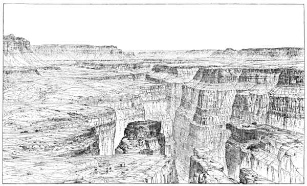
Aside from the lessons of interest to the geologist and geographer so plainly engraved on the surfaces of the plateaus crossed by the Colorado, the region has a wonderful fascination for the purely æsthetic feelings more or less latent in every human breast. To one traversing the open pine forests, in places clothing the plateaus and inclosing many grassy glades and flower-decked parks, in which timid deer may frequently be seen feeding in the early morning, and emerging on the brink of the Grand Cañon, the scene that meets the eye is marvellous beyond all description. C. E. Dutton, to whom we owe some of the most graphic and inspiring descriptions of natural scenery ever written, states that those who have long and carefully studied the Grand Cañon of the Colorado do not hesitate for a moment in pronouncing it the most sublime of all earthly spectacles. "If its sublimity," writes Dutton, "consisted only in its dimensions, it could be sufficiently set forth in a single sentence. It is more than 200 miles long, from 5 to 12 miles wide, and from 5,000 to 6,000 feet deep. But it is not magnitude alone that gives this marvellous cañon its prominence; it is the gorgeous and varied colouring of its mighty walls, the endless details in the sculpturing of its battlements and towers, the ever-changing atmospheric effects of its profound depths, and the wonderful stimulus to the imagination with which it feeds the mind. Standing on the brink of the Grand Cañon, the prosaic search for causes and effects for a time at least must be laid aside, and give place to the emotions."
Wonderfully grand as are the scenes beheld in traversing this region of high plateaus, with its magnificent cliffs and profound cañons, one is constantly reminded that it is an arid land. The higher portions of the plateau, it is true, are in places forested, but over vast areas the rocks are bare. Water is everywhere scarce except in the bottom of the larger excavations. Thirsty, and perhaps perishing, the traveller, Tantalus like, looks down on the shining silvery threads of water in the cañons, hundreds and even thousands of feet below, but separated from them by impassable barriers. To the south the plateaus descend to the desolate valleys of southern Arizona, where strange gigantic cactus-plants and scattered clumps of thorny shrubs alone break the dreary monotony of the hot gravelly deserts. Agriculture is there impossible without irrigation, but where the life-giving waters can be utilized, as in the Gila Valley, marvellous productiveness follows.
THE GREAT BASIN
To the west of the Rocky Mountain belt in the United States there exists a region embracing about 210,000 square miles, which sends no stream to the ocean. This vast and in large part desert tract is known as the Great Basin. The climate is characterized by its aridity. The annual precipitation is small and evaporation active. All the water reaching the land is returned to the air by evaporation, either directly or from the streams and lakes. Many of the lakes do not overflow and are more or less alkaline and saline, while some of them, as Great Salt Lake, Utah, and Mono and Owens Lakes, California, are dense with mineral matter in solution.
Fig. 20.—The Great Basin. Click image to enlarge.
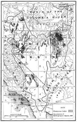
The Great Basin is not a single level-floored depression, as one might infer from its name, but is traversed by rugged mountain ranges, which divide it into a large number of minor valleys. Some of these secondary basins have lakes and streams which escape from them into lower depressions, but in many instances under present climatic conditions they have no surface water, all the moisture that reaches them being absorbed by the thirsty soil or evaporated without forming lakes. The Great Basin proper, as it may be termed, embraces nearly the whole of Utah and Nevada, together with small portions of the southern parts of Idaho and Oregon and a large area in southeastern California. While the drainage conditions limit the application of the name to this group of associated basins which send no tribute to the sea, the climatic and to a less extent the topographic and geological conditions that characterize it have much wider, although indefinite boundaries. This wider region which resembles the Great Basin proper, extends from British Columbia southward to beyond the city of Mexico, and includes the eastern half of Washington and Oregon, a large part of Idaho, and much of Arizona, New Mexico, and western Texas. In this outer region both to the north and south of the Great Basin proper there are drainless valleys, as those of central Mexico, in which the conditions characteristic of the desert valleys of Utah and Nevada are repeated.
The greater region of arid valleys and desolate mountains surrounding the Great Basin proper is crossed at the north by the Columbia and in the central part by the Colorado. Each of these large rivers has its source in the Rocky Mountains and flows to the Pacific.
The most obvious features of the Great Basin and of the northward and southward extensions of the belt of country having much in common with it, depend on climatic conditions. The rainfall is small throughout the entire belt from the Canadian boundary to south-central Mexico. The average mean annual precipitation, judging from such observations as are available, is probably less than 15 inches, but this broad statement does not truly represent the diverse conditions. The rainfall is confined almost entirely to the winter season, and frequently comes in short heavy downpours. During the summer season, the valleys especially, become so parched that only such plants can grow as are adapted to long-continued droughts. The topography is rough and diversified by many mountain ranges, and the precipitation is more abundant on the uplands than in the valleys. Over large areas in Nevada and southeastern California the mean annual rainfall is less than 5 inches. The author, while carrying on geological work in this region, was informed by some of the older settlers that at times for fully eighteen consecutive months no rain whatever fell in certain of the valleys. From the accounts of travellers in central Mexico, it seems as if some of the interior basins in that region must be fully as arid as those just referred to.
One conspicuous result of the lack of moisture is the absence of forests. Except on the mountains mainly at the north the Great Basin and its extensions, as defined above, is nearly destitute of trees. The valleys are in many instances thickly covered with desert shrubs, notably the sage-brush, but the floors of the driest basins are in many instances almost absolutely without vegetation, and are frequently white with saline incrustations.
Many of the depressions in the Great Basin, as well as some of the outlying valleys referred to, have rivers and lakes which exhibit certain interesting features that are unfamiliar to people dwelling in humid lands. The streams are fed in part by the small precipitation on the desert valleys, and by springs, frequently of heated water, but mainly by the rain and melting snow on the mountains. Many rills and rivulets are born on the valley sides of a single storm, but are absorbed by the thirsty soil or evaporated during the succeeding hours of sunshine. Other streams have a greater lease of life and flow down to valleys and basins, suffering evaporation and absorption as they progress, which cause them to diminish in volume, and finally to vanish. The stronger streams, such as Sevier and Bear Rivers in Utah, the Humboldt River in Nevada, and the Truckee River in California, maintain their existence throughout the year, and expand into lakes in which the inflow is balanced by evaporation.
The lakes of the Great Basin present even greater diversity than the streams. Some of those situated principally in the mountains are of pure, limpid, wholesome water, supplied by cool, sweet brooks and rills or by the melting of the winter's snows, and overflow throughout the year. These lakes, usually of small size, are similar in all respects to the ordinary lakes of humid lands. In eastern Utah, adjacent to the west base of the Wasatch Mountains, the Provo River and other streams supply Utah Lake, the outlet of which, the Jordan River, empties into Great Salt Lake. Utah Lake is well within the Great Basin, and situated at a low elevation for the region, namely, 4,500 feet, or about 280 feet (in 1873) above the level of lake of brine into which it discharges. This is the largest of the fresh lakes in the valleys of the Great Basin, and owes its existence to the fact that a depression there occurs which is filled to overflowing by the streams from the mountains. Bear Lake, in northeastern Utah, is another exceptional example of a fresh lake of considerable size at a comparatively low altitude, in the same region. On the western rim of the Great Basin, at an elevation of 6,247 feet, and surrounded by the forested peaks of the Sierra Nevada, lies Lake Tahoe, "the gem of the Sierra," a water body of remarkable purity, which discharges through Truckee River into Pyramid and Winnemucca Lakes. These lower lakes, situated in desert valleys at an elevation of 3,780 feet above the sea, are without outlets and alkaline and bitter. The most characteristic lakes of the Great Basin, however, are those that do not overflow, and on account of concentration by evaporation are more or less highly charged with mineral matter in solution. These saline and alkaline lakes may be divided into two classes, in reference to their duration, but the line of separation is indefinite. Certain of them have maintained their existence for many years, and probably have not been evaporated to dryness for several centuries, and may be classed as perennial lakes; others are evaporated to dryness each year, or during certain exceptionally dry and hot seasons, and may be termed ephemeral lakes. In many instances the beds of the ephemeral lakes are normally in a state of desiccation, and appear as broad, level, mud plains, usually with a white fringe of saline matter. Frequently these mud plains, or playas, as they are termed, are transformed into shallow lakes during a single storm, but the waters are absorbed by the clays beneath or evaporated within a few days or perhaps a few hours after the rain ceases. The largest and most characteristic of the perennial saline water bodies is Great Salt Lake, the counterpart in many ways of the Dead Sea. The streams discharging into this salt sea have the usual purity of river-waters, and carry but a small fraction of one per cent of saline matter in solution. The lake is supplied also in part, but to an unimportant extent, by springs, the most of which are of essentially fresh water. The source of the salts which make the waters of the lake a brine is evidently, therefore, the small percentage of mineral material brought in by the tributary streams. After reaching the lake these fresh waters, in the ordinary meaning of the term, are concentrated by evaporation. This is the explanation of the leading facts in the chemistry of all of the saline and alkaline lakes of the Great Basin region, such as Pyramid, Winnemucca, and Walker Lakes in Nevada, Mono and Owens Lakes in California, and the saline lakes of Mexico.
The volume of a lake without an outlet, or an "inclosed lake," is determined mainly by the ratio of the inflow (including the rain falling directly on its surface and the tribute from springs) and evaporation. Its volume, and consequently its area, fluctuates from season to season, and frequently varies also during periods embracing several years. With variations in volume there are fluctuations in the percentage of saline matter in solution, even if precipitation of one or more of the contained salts does not take place during the periods of more than usual concentration. In most instances inclosed lakes are concentrated by evaporation in summer seasons, and perhaps become nearly saturated solutions, but are diluted during the rainy winter seasons. Fluctuations in volume, area, depth, salinity, etc., are thus characteristic of inclosed water bodies. They are sensitive to climatic changes which ordinary weather records fail to detect, and are modified in a conspicuous manner when the country about them becomes inhabited and irrigation is practised.
Some of the lakes of the Great Basin are dense brines from which various substances are being precipitated. The economic importance of these natural reservoirs of brine and of various soda salts is great, and will become more and more important as transportation facilities increase. Great Salt Lake, it has been estimated, contains 400,000,000 tons of common salt and 30,000,000 tons of sodium sulphate in solution. During the past ten years about 40,000 tons of common salt have been harvested from it annually. Mono Lake contains some 245,000,000 tons of saline matter in solution, of which about 92,000,000 tons are sodium carbonate and bicarbonate. Owens Lake is similar to Mono Lake in composition, and is now the basis of a large soda industry.
A marked difference between a region which drains to the ocean and one where the streams enter inclosed basins where their waters are evaporated is that in the former the waste from the land carried by the streams as an invisible load in solution or as a visible load consisting mainly of silt and sand in suspension is contributed to the ocean and widely distributed before being deposited—much of the material in solution, in fact, may be said to be a permanent contribution to the salinity of sea-water; but in most instances where streams enter inclosed basins all of the material contributed both in solution and suspension is sooner or later precipitated. The area within an inclosed basin, on which the inflowing streams lay down their loads, is as a rule less extensive than the area that is being denuded to supply the material. The receiving basins are thus filled in or aggraded, and there is a concentration both of the mechanical wash from the land and of the substances taken in solution by the waters of streams and springs. A marked result of this process of concentration, particularly of the fine waste of the uplands and mountains, is seen in the approximately level floors of inclosed valleys. Throughout the Great Basin the valleys have been filled to a depth in many instances of hundreds of feet. Some of the lower mountain ranges in Utah have been so nearly buried beneath these valley deposits that only their summits, termed lost mountains, appear above the even surface of the desert plains. This débris, deeply filling the valleys referred to, is usually a fine yellowish dust-like material, similar in many ways, and probably in mode of origin, to the loess of China in which geologists have taken much interest. With the concentration and deposition of the fine mechanical wash of the uplands there has also been a concentration of the more soluble saline constituents of rocks, which causes the soils of arid regions to differ in an important way from those of humid lands. The leached and characteristically red-tinted soils of warm humid countries, consisting of the oxidized residue of deeply weathered rocks, are absent from arid regions; in their place we find minutely disintegrated, usually light-coloured, and not chemically impoverished soils. In warm humid regions chemical decay of the rocks is the conspicuous feature; in equally warm arid lands mechanical disintegration is carried to an extreme, without the removal of the more soluble constituents. In fact, concentration of saline matter, notably common salt, sodium sulphate, gypsum, etc., is one of the functions, so to speak, of arid climates, when the requisite evaporation basins are present. Among the important industries of the Great Basin region is the gathering and purifying of the various salts contained in the existing water bodies and in the basins of desiccated lakes.
In addition to the characteristics of the region referred to above, which are mainly the result of climatic conditions, the Great Basin has certain geological features, in the main, so far as North America is concerned, peculiar to itself. The leading structural features of the rocks, so far as they find expression in the surface relief, is the presence of a large number of extensive faults trending in general about northeast and southwest. These faults are breaks or cracks along which the rocks have been moved up and down. One side of a fault sometimes stands higher than the opposite side, and forms a narrow and frequently high and rugged mountain range. The number of these faults within the Great Basin is as yet unknown, but they certainly number many hundreds. In a cross profile of the region between the Wasatch Mountains on the east and the Sierra Nevada on the west the number of mountain ridges due to faulting is at least a score. The precipitous western border of the Wasatch Mountains is itself a great fault scarp, as is also the eastern border of the Sierra Nevada. The faults that determine the steeper sides of these mountain ranges are not to be considered as single clean-cut gashes, but as irregular and intersecting fractures traversing a narrow belt of country. The faults referred to divide rocks of all ages, and are evidently due to the most recent disturbances that have affected the region. It is not probable that the break in any given instance was formed all at once. Such vast convulsions would be out of harmony with the rules of nature. But rather many small movements and adjustments of pressure have occurred along the same belt of fracture. This conclusion is sustained by the fact that many of the faults have experienced movements in very recent times. In places fault scarps a score or more feet in height cross the alluvial cones at the mouths of the small high-grade valleys in the mountains. These scarps in loose unconsolidated gravel and similar material, even under an arid climate, could not be expected to preserve their freshness for many years. At times the breaks cross the courses of streams and cascades, and rapids are formed by the waters flowing down escarpments thus produced in loose material. One characteristic fault scarp in Inyo Valley, California, is known to have been formed during an earthquake that shook that portion of the country in 1872. The many small earthquakes that have been felt in the Great Basin region are believed to have been caused by slight movements along the breaks that traverse the region. This and other evidence indicates that the faults to which so much of the characteristic scenery of the Great Basin is due have grown by repeated minor displacements, and that such movements are a common cause of earthquakes.
The most conspicuous topographic features of the better known portion of the Great Basin are long, narrow, and frequently sharp-crested ridges, with a gentle slope on one side and a steep escarpment on the other. The steeper side in a large number of instances is known to be the upraised side of a fault. Each of these basin ranges, as they are termed, may be considered as the upturned edge of a block of the earth's crust, in general from 60 to 100 or more miles long, and 10 to perhaps 20 miles wide. The crest-lines of the tilted blocks are frequently serrate, on account of differences in the hardness and texture of the rocks and the effects of weathering. There is frequently, however, an older structure revealed in them, showing that the region was folded and otherwise disturbed previous to the later movements which produced the leading features in the present topography. It is probable that this older structure in some instances has had an important bearing on the forms of some of the ranges, but our knowledge in this direction is too limited to warrant presentation in a popular treatise.
Many of the basin ranges are imposing on account of their height and ruggedness, when seen from the adjacent, deeply filled valleys, although scarcely more than half of their actual elevation above the sea is revealed from such points of view. Exceptions to this general statement occur, however, in southeastern California, where, in Death Valley, the land is 480 feet below sea-level. This is the only region in North America which, like the basin of the Dead Sea, is below the level of the ocean's surface. On the border of Death Valley the mountain ranges rise from 6,000 to 10,000 feet, and the highest summit, known as Telescope Peak, is reported to have an elevation of nearly 11,000 feet above the sea. In the central and northern portions of the Great Basin the valley floors have a general elevation of from 5,000 to 6,000 feet. The mountains rise from these valleys to a height of from a few hundred to 4,000 or 5,000 feet. Among the highest, if not actually the culminating peaks well within the Great Basin are White Mountain, on the California-Nevada boundary, about 30 miles southeast of Mono Lake, which has a summit elevation of 13,000 feet, and Jeff Davis Peak, in eastern Nevada, which rises 13,100 feet above the sea and 8,000 feet above the adjacent valleys.
The numerous sharp-crested ranges of the region under review are frequently remarkable for the richness of the colours of the naked rocks. The mountain slopes and towering angular summits when outlined against the morning or evening sky are frequently as brilliantly dyed as are the New England hills when clothed in the harlequin foliage of autumn. Before sunrise and after sunset each serrate crest-line is the sharply cut border of a silhouette of the deepest and richest purple. The diversity of scenery in the Great Basin is increased by mountains of volcanic origin, including several modern craters, some of which hold lakes, and by lava-flows of recent date, and by great alluvial fans or detritus cones which stream out into the valleys from the mouths of gorges in the bordering mountains.
The Great Basin proper, with its rugged topography and arid climate, is not an agricultural region. Small portions of it, however, when water can be had for irrigation, have been transformed into fruitful farms and gardens which yield bountiful returns. But even a century hence, when all has been accomplished in the way of reclaiming the arid valleys that can be done by utilizing the available water for irrigation, only a small per cent of the whole will be under cultivation.
SIERRA NEVADA AND CASCADE MOUNTAINS
To the west of the Great Basin, and extending from southern California northward to beyond the United States-Canadian boundary, there is a lofty and extremely rugged belt of mountains consisting of two ranges—the Sierra Nevada at the south and the Cascade Mountains at the north. Topographically, these two ranges form a single elevated belt of country, but custom, and as is now generally understood the geological structure and history, draws a dividing line between them in northern California. The Sierra Nevada-Cascade range extends far into Canada, and is there known as the Coast Range. No adjustment of the nomenclature in use on the two sides of the international boundary has been made, and in order to conform with current usage, it is necessary to consider separately the two portions of the range on opposite sides of the forty-ninth parallel.
The Sierra Nevada has its southern terminus at Tejon Pass, in southern California, and extending from there northward to Lassen Peak, in the northern part of the same State. With the exception of a small area to the east and north of Lake Tahoe, the entire range is included within the boundaries of California. This is geographically one of the best defined of the larger mountain ranges in the United States. Its eastern border especially is easy to trace, as for the most part it is determined by a great escarpment, corresponding to the fault scarp which borders one side of so many of the basin ranges. The Sierra Nevada, in fact, may be considered as one of the basin ranges of great size and forming the western wall of the region of interior drainage lying to the eastward. This abrupt eastward-facing mountain slope is in reality a great fault scarp, formed mainly by the upheaval of the west side of an intersecting system of fractures. It is not known, however, how much of the escarpment is due to the upheaval of the west side of the belt of fracture, or how much to the sinking of the eastern side. There have no doubt been many up and down movements along this belt, of which the present mountain wall is the algebraic sum. The escarpment rises in general from 5,000 to 6,000 feet above the desert valleys to the eastward, and reaches a maximum of about 14,000 feet in the vicinity of Death Valley. It is exceedingly precipitous and rises to an irregular serrate crest-line, from which the general slope westward to the Great Valley of California is gentle.
The best idea of the generalized topographic form as well as of the origin of the Sierra Nevada, which the reader may be asked to hold in mind, is that the range consists of a block of the earth's crust about 500 miles long and from 70 to 100 miles broad, which has been upraised along its eastern edge so as to give its surface a westward inclination. From this vast monolith the profound cañons and multitude of sharp tapering spires which give to the range its magnificent scenery have been sculptured. Like most generalized pictures of great geographical features, however, this outline of the form and structure of the great mountain range of California has to be modified when studied in detail. From extensive and most painstaking studies by H. W. Turner, of the United States Geological Survey, the conclusion is reached that "the Sierra Nevada may be described as a monogenetic range, composed of highly compressed schists and slates with large areas of associated igneous rocks, chiefly granite and diabase, upon which lie uncomfortably a series of later Cretaceous and Tertiary sediments and volcanic rocks."
Could the profound valleys carved in the long western slope of the Sierra Nevada be filled so as to restore the conditions as they existed when the mountain block was first upraised and tilted, we would have an inclined plane in which the edges of previously folded rocks would be exposed. In other words, the western slope is a tilted peneplain, bearing on its surface remnants of older uplands. High up on the range there are detached areas of well-worn gravel, which were deposited when the slopes were less inclined than at present, and before the existing peaks and cañons came into existence. Certain of the valleys carved during a portion of the earlier stage of erosion were subsequently filled by lava-floods, which buried gold-bearing gravel beneath thick layers of basaltic rock. Erosion has since cut away the softer beds bordering these ancient lava-sheets, and left them in bold relief as table mountains, underneath which miners have excavated tunnels in order to reach the stream-deposited gravels of the ancient cañons. In these instances valleys have been changed to uplands, owing to the resistance to erosion afforded by the volcanic rocks discharged into them.
The long gentle slope on the west side of the Sierra Nevada has been dissected by westward-flowing rivers, which have sunk their channels 2,000 or 3,000 feet or more into the rocks. Other streams having much shorter courses flow down the steep eastern slope of the range and have also excavated cañons. These two systems of drainage, one leading westward to the Great Valley of California and the other eastward to the valleys of the Great Basin, extended their head branches until they came into rivalry with each other, and cut deep notches in the crest of the range. During a late stage in its history the higher portions of the mountains were covered with a great field of perennial snow, from which glaciers flowed both eastward and westward. These ice-streams, by deepening and broadening the previously water-cut channels, still further increased the diversity of the topography and impressed upon it characteristics such as only glaciers can produce.
The highest and most typical part of the Sierra Nevada is in its south-central portion, and is known as the High Sierra. This region, although at present not accurately defined, is well worthy of recognition. Throughout its entire extent, from the neighbourhood of Lake Tahoe on the north to Tehichipe Pass at the south, a distance of about 240 miles, it is diversified by rugged serrate peaks and narrow stream-cut valleys of great depth. Many of the mountains attain elevations of from 12,000 to over 13,500 feet. The highest summit is Mount Whitney, in the southern part of the range and near its eastern border, which rises 14,522 feet above the sea and has the added distinction of being the highest mountain in the United States, exclusive of Alaska. It is a notable fact that this great mountain-peak should be situated only about 100 miles from Death Valley, the lowest depression on the continent.
Another of the remarkable features of the Sierra Nevada is the great depth and the wonderfully precipitous walls of some of the valleys carved by the westward-flowing rivers. The most famous of these is the sublime Yosemite Valley, now world-renowned. This cleft as it appears in solid light-coloured granite, over a mile deep, is believed by Turner, the last of several geologists to discuss its origin, to be due to stream erosion. The fact seems well established, however, that glacial ice has assisted in the great task. The Yosemite is not such an unique feature as was at one time supposed, but is approached if not equalled in depth and magnificence by Hetch Hetchy Valley, through which flows the Tuolumne River, and is duplicated, in part at least, by other similar stream-cut gulfs.
Among the chief elements in the glorious scenery of the Sierra Nevada is the multitude of lakes left as a rich inheritance by the departed glaciers. These occur not only high up amid the bare peaks where their basins were excavated by the flowing ice, but also in the lower valleys where the ancient ice-streams built morainal dams.
The High Sierra was swept nearly clean of soil and débris by the ancient glaciers, and the hard rocks thus exposed were rounded and burnished by the ice that flowed over them. But little disintegration or decay of the rocks has taken place since an amelioration of climate changed the drainage from a solid to a liquid form. On account mainly of the general absence of soil the forests are less dense than might be expected from the height of the regions where they occur and its general climatic conditions. The more lofty peaks reach far above the forests and are riven and shattered by frost. The crests and cliffs at somewhat lower altitudes are also bare, but in the cañons and on the meadow-like valley bottoms smoothed by the glaciers, open park-like groves of pine and spruce grow in picturesque disorder. On the ledges of the great precipices, and on many of the secondary summits, gardens of alpine flowers blossom in late summer, and at times impart a rich warm glow to the heights that support them. The views of nature, unmarred by the hand of man, which reward the persistent mountaineer in this silent wonderland of the upper world, are not only grand beyond all description, but beautified by a delicacy of decoration where snow-fields and alpine gardens meet, that is undreamed of by the dwellers in the denser air of the plains and seaside. Lovers of nature who are unable to climb the towering summits of the High Sierra and see for themselves the marvellous beauty there so lavishly displayed can at least find a glowing pen picture of it in John Muir's fascinating book The Mountains of California. On the lower western slope of the Sierra Nevada the forests become continuous and luxuriant, the trees are of large size, and the lovely flowers carpeting the valleys and hillsides take on a more familiar appearance than the gorgeous blossoms of the alpine meadows. It is in this region that the gigantic Sequoia still lingers as a remnant of a nearly extinct flora.
Statements of heights and depths, of geological structures, and of topographic forms are perhaps necessary to enable one to form a mental picture of a snow-crowned mountain range which will bear some faint resemblance to the mighty original; but when one threads his way through the resinous forests on the lower slopes of the Sierra Nevada, ascends some one of the profound water-cut rifts in its side, scales the steep cliffs, traverses the crystal surfaces of the small glaciers, and finally stands on a spire-like summit covered only by the dark blue of the dome above, all thoughts of the arches and walls that support the mighty cathedral are lost in wrapt wonder and admiration of the magnificent scene about him. It is this intense feeling for the sublime and beautiful in nature that the student of geography should strive to cultivate, as well as to acquire skill in reading the prosaic history written everywhere on the mountains. This important lesson can seldom be studied to greater advantage than amid the silent awe-inspiring peaks of California.
The Cascade Mountains, as previously stated, are a direct continuation, so far as the relief is concerned, of the Sierra Nevada. The geological structure of the region in northern California, where the two ranges approach each other, has been studied by J. S. Diller, of the United States Geological Survey, who concludes that they present characteristic differences. In the Cascade Mountains in northern California, Oregon, and southern Washington the rocks exposed at the surface are mainly, if not entirely, of volcanic origin, and were poured out in a molten condition as lava-flows, or as fragmental ejections from volcanoes, and in part rose through fissures and formed what are termed fissure eruptions. The rocks thus extruded are mainly composed of dark, heavy basic material, such as basalt and andesite. These outpourings of molten rocks were on a grand scale, and a large number of volcanic mountains were formed which still remain as the dominant peaks of the rugged and densely forested Cascade Range. Although the evidence now available seems to show that there is a striking difference between the Sierra Nevada and the Cascade Mountains, another significant change occurs when one follows the Cascade Mountains into northern Washington. Where the Northern Pacific Railroad crosses the range the volcanic rocks are succeeded northward by granites, schists, serpentine, etc., and Cretaceous and Tertiary sedimentary beds of much the same character as those in the Sierra Nevada.
The study of the Sierra Nevada-Cascade region has not progressed far enough to warrant a decision, but the fact referred to above strongly suggests that the two ranges, as we now term them, are essentially a single uplift, a large portion of which, extending from Lassen Peak, in California, northward across Oregon and into Washington as far as the Northern Pacific Railroad, is buried beneath a great blanket, so to speak, of lava-flows. The tract of elevated and rugged country in northern Washington embraced in the Cascade Mountains, as has been observed by the writer, passes into Canada without a marked change in either its geology or geography, and there is no occasion for a change of name when the international boundary is crossed.
The Cascade Mountains in Oregon and southern Washington, where the surface rocks are mainly and perhaps wholly of volcanic origin, are rugged for two principal reasons: First, volcanic energy has built up great individual peaks; and second, erosion has carved deep valleys and numerous ravines and gorges. The volcanoes are now extinct, or have long been dormant, and their cold summits are in several instances crowned with perennial snow and small glaciers. The forms given to the more prominent elevations by the eruptions which built them have to a great extent been defaced by erosion. As they stand to-day they furnish an instructive series of more or less deeply dissected volcanic mountains.
Fig. 21.—Crater Lake in the summit of Mount Mazama, Oregon.
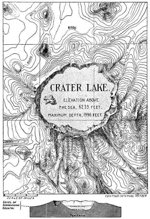
Not only has erosion changed the characteristic slopes of the peaks built of lava-flows and ejected fragments, but in at least one remarkable instance the volcanic energy itself greatly altered the structure it had previously raised. Mount Mazama, situated in southern Oregon in the summit region of the Cascades, is a truncated volcanic cone in the top of which there is an immense depression now partially filled by the waters of Crater Lake (Fig. 21). The main features in the history of this unique mountain with a lake in its summit, as interpreted by Messrs. Dutton and Diller, of the United States Geographical Survey, are as follows: It once stood as a conical peak, similar to several other mountains of volcanic origin in the same region, some 15,000 feet in height; it was then an active volcano with a summit crater filled with lava, but subsequently, for a time at least, became dormant and was occupied by glacial ice. At a later period an escape for the lava was furnished by a fissure or other opening which admitted of a surface discharge at a more or less distant locality, in a manner similar to the escape of the molten rocks from the great volcanoes of the Hawaiian Islands within historic times. This drawing off of the lava from the crater removed the support afforded its walls from within, and the summit portion of the mountain, embracing about three-fourths of its height above the adjacent valleys, fell in and was engulfed. The mountain was thus truncated, and presents the general appearance of similar cones the upper portions of which are known to have been blown away by explosions. But in the case of Mount Mazama, the hypothesis of truncation by explosion seems to be disproved by the absence of the fragments of the portion removed on the slopes remaining or on the surrounding region. After the falling in of the summit of the mountain comparatively mild volcanic explosions followed which built a cone within the great pit or caldera in the summit of the truncated mountain, but without filling it. The space left vacant is now occupied by water, and thus transformed into a lake. The cone built after the catastrophe referred to now forms Wizard Island, near the southwest border of Crater Lake.