Chapter VI · SOME REMARKS ON THE COMPARATIVE GEOGRAPHY OF THE WESTERN AND NORTHERN PARTS OF ASIA MINOR.
Reading edition
Principal places in Peræa Rhodia—in Doris—in Caria—in the valley of the Mæander—in the valley of the Caystrus—on the coast of Ionia—in the valleys of the Hermus and Caicus, and in the adjacent country—in Troas—in Bithynia—in Paphlagonia.
It remains to submit to the reader some observations in justification of the ancient names in the western and northern parts of the map which accompanies the present volume. It will not be necessary to enter into this part of the subject so fully as into those which have already been under consideration. The western provinces, in consequence of their celebrity and greater advantages of climate, soil, and situation, have been more fully described, both by ancient and modern writers; so that, in conducting the reader to the results recorded on the map, a general reference on the one hand to the travellers whose routes are there marked, and on the other to the ancient historians, geographers, and itineraries, will be sufficient. In those instances only, it may be necessary to be more particular, where the ancient positions are determined by less obvious authorities or by unpublished documents, or where the question is rendered doubtful by deficient or conflicting evidence. As to the north-eastern part of the peninsula, we must be contented with a brief notice of its geography, for a reason the reverse of that which induces me to abridge the geographical notice of the provinces bordering on the Ægæan sea. The distance of Paphlagonia and Eastern Bithynia from the centre of Grecian civilization, and the little attention which those countries have received from ancient history, have hardly tempted a single traveller to trust himself among their barbarous tribes, or to explore their mountains and forests; and hence the evidences of the geography of that country, both ancient and modern, are extremely imperfect.
I shall begin from the western extremity of Captain Beaufort’s Survey, and shall proceed to the westward and northward from the same point at which the remarks of the preceding chapter set out in the opposite direction. It so happens that Dædala is precisely the point at which Strabo also changes the course of his observations; and from which, after describing the coast of Caria with the adjacent islands and continent in a western direction, he proceeds, as we have seen in the translated extract at the beginning of the last chapter, to direct his description of Lycia, Pamphylia, and Cilicia, from west to east.
Captain Beaufort not having surveyed any part of the coast between Telmissus and Halicarnassus, excepting that near Cnidus; and no traveller having pretended to publish a delineation of it, except M. de Choiseul Gouffier, whose map is too obviously incorrect, both in construction and in detail, to merit much attention; this part of the coast-line of Asia is more subject to a suspicion of inaccuracy than any other. The important positions of Rhodus, Cnidus, Cos, and Halicarnassus, are indeed ascertained by the observations of Captain Beaufort, and I have derived some assistance from a few measurements taken with the compass and sextant from the same places, by Sir William Gell; but no reliance can yet be placed on the outline of the gulfs of Syme and Kos: even the extent of those magnificent bays is very uncertain, and nothing is known of the situation of the numerous towns and islands placed in them by the ancient authors, especially by Pliny: in short, the exploring of these two gulfs with that of the coast in the vicinity of Caunus, is now one of the most interesting desiderata in the geography of Asia Minor.
Strabo[300] describes Peræa as beginning at the fort and mountain Dædala, near Telmissus, and as ending at mount Phœnix, both places included. “Next to the gulf Glaucus occurs the cape and temple Artemisium, and then the grove of Latona; above which, 60 stades inland, is the city Calynda, then Caunus, a city with docks and a closed port; and near it the Calbis, navigable by boats. Between Caunus and the Calbis is Pisilis; and on a height above Caunus is a fort named Imbrus. The next place on the coast to Caunus is Physcus, a small city which has a harbour and a grove of Latona; then the rugged coast of Loryma, the highest mountain above which is named Phœnix, and has a castle of the same name on its summit. Before this coast lies Elæussa, 4 stades from the sea, 8 stades in circumference, and 120 stades distant from Rhodus. Beyond Loryma is the cape Cynossema and the island Syme.”
As it appears from another passage in Strabo[301], where he cites Artemidorus, that the common road from this coast to the northward, was from Physcus by Alabanda and Tralles, there seems little doubt that Physcus was at Mármara, which is still the usual place of debarkation from Ródos to those going towards Ghiuzel-hissár and Smyrna.
The distances of Elæussa and port Cressa from Rhodus, as given by Strabo and Pliny[302], are sufficiently accurate to identify those two places. The excellent harbour of Cressa is now called Aplothíka by the Greeks, and Porto Cavaliere by the Italians, and on its western shore are the ruins of a Hellenic fortress and town, which are undoubtedly those of Loryma; for Loryma is called a city by Seneca[303] and Stephanus, although not so designated by Strabo or by Pliny; and port Loryma is described by Livy as being opposite to Rhodus[304], at a little more than the distance[305] which Pliny assigns to Cressa. The order of names on this coast in Ptolemy[306] is in exact agreement with the other authorities which I have cited in proof of their position, as marked on the map, if we suppose his cape Onugnatus to be the same as the Cynosema of Strabo.
Although Choiseul Gouffier must have nearly crossed the sites of Dædala and Calynda, he did not ascertain the position of either of them: nor has that of Caunus, the chief city of Peræa, yet been explored. The promontory called by Strabo Artemisium, from the temple of Diana which stood upon it, appears to have been the same as the Pedalium of Pliny and the Stadiasmus, and to be the cape now called Bokomadhi.
The Clydæ, which the Stadiasmus[307] names between Pedalium and Crua (Crya) is evidently the same as the Chydæ, which Ptolemy places a little to the westward of Crya, and Crya is undoubtedly the Cryassus of Stephanus and Plutarch[308]. We are not surprised at finding in the modern town of Ródos an inscription[309], in which Cryassus and Chalce (the island still called Khalki) are alluded to, both these places having been dependencies of the Rhodian republic. The islands off the coast of Dædala and Crya are noticed by Pliny[310], who says there were two belonging to the Dædalenses; and three, two of which are by Stephanus[311] named Alina and Carysis, belonging to the Cryenses.
In consequence of our ignorance of the actual topography of the gulfs of Doris and Ceramus, I have not attempted to place any of their towns, even conjecturally, except Euthenæ, which is stated by Mela[312] to have been in a bay between Cnidus and the Ceramic gulf: Bargasa and Ceramus are described by Strabo[313] as being near the sea, between Cnidus and Halicarnassus; and Passala, an island in the same gulf, was the port of the Mylassenses[314]. The modern name Kéramo, which, if it exists, identifies the site of Ceramus, rests, I believe, solely upon the authority of D’Anville.
The Dorian colonies from the Peloponnesus, which settled in Halicarnassus, Cnidus, Cos, and in the three cities of Rhodus, introduced the use of Doric architecture, and of the Doric dialect, into this angle of Caria. Remains of Doric buildings are found at Lindus, Cnidus, and Halicarnassus[315]; and inscriptions in the Doric dialect have been found in most of the cities of the Hexapolis. It appears that they had not neglected the latter mark of their origin in the early ages of the Roman empire[316].
The conversion into a peninsula of the island on which Strabo and Stephanus represent Jasus (now Asýn Kale) to have stood, is probably a remote effect of the encroachments of the Mæander upon the sea. We find another instance of the same kind at Caryanda: for there can be little doubt that the large peninsula, towards the western end of which is the fine harbour called by the Turks Pasha Limáni, is the ancient island of Caryanda, now joined to the main by a narrow sandy isthmus. Pasha Limáni (the port of the Pasha) is the harbour of Caryanda, noticed by Strabo, Scylax, and Stephanus; its position according with that of the other places along this coast, as described by Strabo. “Next to Halicarnassus,” he says, “is Termerium, a cape of the Myndii, opposite to cape Scandaria of Cos.... Proceeding towards Myndus are the capes Astypalsæa and Zephyrium; and immediately beyond the latter, the city Myndus, with a harbour; then Bargylia, also a city, between which and Myndus is the harbour and the island of Caryanda[317]. Near Bargylia is the temple of Diana Cindyas. Next occurs Iasus.”
We can hardly doubt that Myndus stood in the small sheltered port of Gumishlú, where Captain Beaufort remarked the remains of an ancient pier at the entrance of the port, and some ruins at the head of the bay. The cape to the southward of this port will consequently be Zephyrium; and it is not improbable that the ruins which the same traveller observed at Kadí Kálesi, in a bay on the south side of that cape, are those of a small ancient town of the same name, which has not been noticed by the ancient authors.
Such having been the situation of Myndus and of Caryanda, Bargylia (called Andanus[318] in the Carian language) should be sought for on the coast between Pasha Limáni and Asýn Kálesi: this position, it may be added, agrees with that which Mela[319] ascribes to Bargylia, as well as with the fact that the gulf of Iasus was often called the gulf of Bargylia[320].
Of the interior cities of Caria, Stratoniceia is shown to have been at Eski-hissár, by the important ruins which have given rise to the modern name, in conjunction with an inscription[321] found there, which relates to Jupiter Chrysaoreus, the deity particularly worshipped at Stratoniceia.
The names of Lagina and Mylasa still subsist, slightly corrupted. Of the latter city there are many remains; but that which constituted its most remarkable antiquity in the time of Pococke, the temple of Rome and Augustus, was destroyed about the middle of the last century by the Turks, who built a new mosque with the materials[322].
The situation of Alabanda is still doubtful; and the ancient testimony on that of Labranda is so much connected with it, that the same uncertainty prevails as to the site of the latter. The following is the substance of what Strabo says of these places:
Labranda was a dependency of Mylasa, distant from thence 68 stades, and situated in the mountain over which lay the route from Mylasa to Alabanda. As far as Labranda there was a paved road, which, as leading to the temple of Jupiter Stratius, (otherwise named Labrandenus,) was called the Sacred Way[323]. Alabanda stood at the foot of a hill with a double summit, which resembled an ass bearing a pack-saddle. It was situated near a very winding river, and its territory was separated by a ridge of hills from that of Mylasa[324].
Pococke and Chandler supposed Alabanda to have been at Karpúsli, where they found sepulchres and the remains of public buildings, of a theatre, and of town walls; and Chandler was the first to describe the ruins (at Iakli, not far to the southward of Kizeljik or Mendeliat,) of a small fortified town containing a theatre, and a ruined temple of the Corinthian order, of which 16 columns of 2½ feet in diameter, with a part of the entablature, were standing in the year 1776. This, Chandler supposed to have been the temple of Jupiter of Labranda[325]. M. de Choiseul Gouffier[326] and M. Barbié du Bocage[327] were of a different opinion. Without pretending to determine the position of Alabanda, they agreed in thinking that the ruins at Iakli are those of Euromus, which we know from Polybius and Livy[328] to have been one of the most important places in this part of the country, at the time of the Roman wars; and from Strabo, to have been situated, as the ruins at Iakli are, near the eastern extremity of Mount Grium[329]. It appears, moreover, from a coin of the emperor Caracalla[330], that the Jupiter of Euromus had considerable celebrity; to him, therefore, the existing temple may have been sacred, and not to Jupiter of Labranda: in favour of which opinion, it may be added that the temple of Labranda was noted for its antiquity, whereas the architecture at Iakli is of Roman times.
On the other hand, it may be remarked that the distance of Iakli from Mylasa agrees tolerably with the 68 or 70 stades between that place and Labranda; that supposing Alabanda to have been at Karpúsli, the direction of Iakli from Mylasa is not much to the left of a line drawn from thence to Karpúsli: and that the deviation is a natural consequence of the projection westward of the range of hills, a part of which overhangs the temple at Iakli.
There are some reasons, however, for thinking that Alabanda was not at Karpúsli, but at Arabissár. 1. Pococke describes the ancient remains at Arabissár as consisting of town-walls, a theatre, and a large oblong Roman building with windows, which appeared to him to have been intended for public assemblies: he adds that the city occupied the slope and foot of two hills. Now the two hills accord with Strabo’s description of Alabanda; and the oblong building may have belonged to the Roman conventus of which Alabanda was the chief town[331]. 2. The river Tshina, near Arabissár, accords extremely well with the river upon which Alabanda was situated; as do the mountains which separate its valley from the plain of Mylasa, with the geographer’s words, ἡ μεταξὺ ὀρεινὴ, relating to the mountain between Mylasa and Alabanda.—3. The other words of Strabo, descriptive of the situation of the temple, ἐν τῷ ὄρει, and of the road which led to Labranda from Mylasa, tend to show that the temple was on a mountain, and that the road thither did not lead through a plain like that from Mylasa to Iakli. It may be added, 4. that the ancient gate at Mylasa, upon which Chandler observed the figure of a hatchet, the symbol of Jupiter Labrandenus, and from which he inferred that it was the gate leading to Labranda, does not open towards Iakli, but faces the east towards the mountain and Arabissár[332]. Upon the whole, therefore, I am inclined to think that Alabanda was at Arabissár, and Euromus at Iakli; and that the vestiges of Labranda will hereafter be found on the mountain to the north-eastward of Mylasa. The ancient remains at Karpúsli are perhaps those of Orthosia. This was a place of some importance; and we know that it was situated in the country to the southward of the Mæander, opposite to Tralles and Nysa; that it was not far from Coscinia[333], and that Coscinia was upon the same river as Alabanda[334].
If Alabanda was at Arabissár, Tshina, where Pococke[335] found considerable remains, may be the site of Coscinia, and its modern name may possibly be a corruption of the ancient.
M. Barbié du Bocage[336] has with great reason supposed that the river of Tshina was the branch of the Mæander called Marsyas by Herodotus[337]. The historian describes the Marsyas as flowing from the country of Idrias into the Mæander; and he relates that the Persians under Daurises having met the revolted Carians not far from the junction of the two streams, the Carians were defeated, and retired to Labranda, where they took up a position in the sacred grove, and were joined by the Milesii and others of their allies. They were defeated a second time, and the Persians continued to advance into Caria, until the Carians, attacking the invaders by night on the road to Pedasus, were in their turn victorious, and slew Daurises and several others of the Persian leaders. It is evident that the Marsyas of which the historian here speaks was a Carian river, totally different from the stream or fountain of the same name at Celænæ, the course of which was not longer than that city itself[338]. Idrias was one of the earlier names of the city, which under the Macedonians assumed the name of Stratoniceia, and its territory included Lagina, celebrated for a temple of Hecate[339]. The latter place still preserves its ancient name, and not far from it are the sources of the Tshina. It may be further observed, in confirmation of the identity of this river with the Marsyas of Herodotus, that the retreat of the Carians from its valley into the hills to the westward was a very natural movement, and perfectly conformable with the other circumstances of these transactions.
In opposition to the placing of Alabanda at Arabissár will perhaps be adduced the distances on the road which led from Physcus by Tralles to Smyrna, as stated by Artemidorus, and preserved by Strabo[340]. These distances are from Physcus to Lagina 850 stades, to Alabanda 250, to the Mæander, which was the boundary of Caria, 80, to Tralles 80, to Magnesia 140, to Ephesus 120, to Smyrna 320,—total from Physcus to Tralles 1260, from Tralles to Smyrna 580. The numbers from Tralles to Smyrna agree tolerably well with the reality: but it is sufficient to refer for a moment to the map, to perceive how totally unworthy of credit those on the road from Physcus to Tralles must be, both in the aggregate and in detail. The 1260 stades are represented on the map by only 60 geographical miles in direct distance, making more than 20 stades to a mile. Instead of 850 stades from Physcus to Lagina, there could not have been with all the windings of the road more than 300; nor are there more than 50, instead of 80, from the Mæander to the ruins of Tralles. The evidence of position derived from this passage may therefore be rejected, except inasmuch as it shows that Alabanda lay in the road from Physcus to Tralles.
The second-rate places of Caria, dependent upon the chief cities of the coast, or upon the three great towns of the interior, were Euromus, Chalcetor, Heracleia, and Amyzon[341].
As Mount Grium extended from the Milesia eastward to Chalcetor and Euromus[342], Chalcetor would perhaps be found, supposing Euromus to have been at Iakli, at the foot of the mountain which lies between that place and Asýn Kálesi.
The Heracleia mentioned by Strabo among the four smaller towns of the interior of Caria, is not the same as the Heracleia under Mount Latmus which he describes elsewhere, for this was a maritime town. It must therefore be the same which Ptolemy distinguishes from Heracleia of Latmus (πρὸς Λάτμῳ) by the name of Heracleia of Albanum (πρὸς Ἀλβάνῳ). Whether Albanum was the name of a river or mountain it is difficult to say;—but the traveller might perhaps seek for the site of this Heracleia, with some prospect of success, in the situation in which it stands in the enumeration of the towns of this country by Pliny[343], namely, between Euromus and Amyzon.
The ruins of the citadel and town-walls of Amyzon are to be seen on the eastern side of Mount Latmus on the road from Bafi to Tchisme, one hour short of the latter, and a little above some villages called Kafaslár. Mr. Hamilton here copied an inscription in a very defective state of preservation, of which however some of the expressions are distinguishable. Towards the beginning I observe ΑΜΥΤΟΝΕΩΝ and ΧΑΙΡΕΙΝ. When the letters of the inscription were perfect, the former word was undoubtedly , and it proves that these remains belonged to Amyzon[344]. Mixed with Hellenic ruins, there are others at this place, of the date of the Byzantine empire,—a circumstance which agrees with the mention made of Amyzon among the places of Caria in Hierocles, and in the list of Greek bishoprics.

The city of Latmus or Heracleia at Mount Latmus has preserved considerable remains of its walls, together with many sepulchres and a small temple. These ruins are found at the foot of a rocky mountain, the ancient Latmus, on the shore of a lake, which takes its name from the village of Báfi near the eastern extremity. This lake is the Latmic Gulf described by Strabo[345], but which since his time has been separated from the sea by the new plain formed at the mouth of the Mæander. Chandler, not adverting to this remarkable change, mistook the lake of Báfi for that of Myus, and consequently the ruins of Heracleia for those of Myus—an error which was corrected by M. de Choiseul Gouffier. With this adjustment, and the undoubted landmarks afforded by the fine ruins of Priene at Samsún[346], and by the theatre of Miletus at Palátia, we have accurate data for judging of the progress of the encroachments of the Mæander upon the sea, as well as for determining the sites of the two towns of Pyrrha and Myus, the situation of which relatively to Miletus is accurately described by Strabo[347].
The reader has perceived that in the question concerning the site of Alabanda, that of Tralles has been assumed to have been at Ghiuzel-hissár. It is now time to show that Smith, as well as Pococke and Chandler, who too blindly followed the opinion of Smith, were wrong in supposing that town to stand on the site of Magnesia—an error which infallibly led to others of equal importance. M. Barbié du Bocage in the notes to his translation of Chandler gave convincing reasons for thinking that Ghiuzel-hissár occupied the position of Tralles: but it was not until Mr. Hamilton explored the ruins of Magnesia at Inekbazar[348], and discovered the ruins of the celebrated temple of Diana Leucophryene, (which has since been measured and drawn by the Mission of the Society of Dilettanti,) that the question could be considered as satisfactorily determined. The decisive reasons in proof of the positions of Magnesia, Tralles and Nysa, as marked on the map at Inekbazar, Ghiuzel-hissár and Sultan-hissár, respectively, shall here be stated as briefly as possible.
1. Magnesia was according to Pliny 15 miles[349], and according to Artemidorus 120 stades[350] from Ephesus. This is about the real distance of Inekbazar, and not half that of Ghiuzel-hissár, from the ruins of Ephesus at Aiasolúk.
2. Tralles was on the road from Physcus to Ephesus[351]. But had Magnesia been at Ghiuzel-hissár, Tralles, which was 18 miles according to one author[352], or 140 stades according to another[353], to the eastward of Magnesia, must have been about Atshá, which is very much out of the direction from Mármara to Ephesus.
3. We are told by Strabo, that to the traveller going from Magnesia to Tralles, with Mount Messogis on his left hand, the plain on his right belonged to the Magnetes, and to the people of Myus and Miletus[354]. But the two last places were too distant to have possessed any part of the plain opposite to Ghiuzel-hissár and Atshá.
4. Strabo describes Magnesia as situated in a plain at the foot of a mountain called Thorax, not far from the Mæander, but nearer the Lethæus a stream flowing from Pactyas a mountain of the Ephesii[355]. This description agrees precisely with Inekbazar, in face of which are two insulated hills, which, when all the plain of the Mæander below Inekbazar was sea, were two islands called Derasidæ and Sophonia[356]. Besides the town-walls, theatre, stadium[357], and other indications of the site of a great city, are the vast prostrate fragments of an octastyle Ionic temple, the peristyle of which was near 200 feet in length, and was formed of columns more than 4 feet and a half in diameter. It agrees perfectly with the description given of the temple of Diana at Magnesia by Vitruvius[358] and Strabo[359]; the former of whom informs us that this building was a pseudodipterous octastyle of the Ionic order, and the latter that it was larger than any temple in Asia except those of Diana Ephesia and of Apollo Didymeus, and that it surpassed even the Ephesian temple in harmony and in the construction of the cell (τῇ εὐρυθμίᾳ καὶ τῇ τέχνῃ τῇ περὶ τὴν κατασκευὴν τοῦ σηκοῦ πολὺ διαφέρει). Among the ruins are seen inscribed pedestals which formerly supported statues of Nerva and Marcus Aurelius; one of these is dedicated by a high priest and scribe of the Magnetes; and on another fragment were found the names of some priestesses of Artemis Leucophryene[360].
5. The ruins of Tralles are found above the modern town of Ghiuzel-hissár, in a situation such as Strabo[361] has described—a table summit strong by nature (ἵδρυται ἐπὶ τραπεζίου τινὸς, ἄκραν ἔχοντος ἐρυμνήν). The only ruin well defined is that of the theatre and stadium, which formed one building. The Ionic temple of Æsculapius built by Argelius, which Vitruvius mentions[362], as well as the other works of the purer times of Grecian art, seem to have been buried by earthquakes beneath the ruins of later buildings; among which are many remains of the architecture of the Lower Empire, vestiges of the restoration of Tralles by Andronicus Palæologus[363]. Pococke copied a Latin inscription at Ghiuzel-hissár in which the name of Tralles occurs, but without having observed it. It is found also in two inscriptions copied at Ghiuzel-hissár by Sherard. The site of Tralles is traversed by a torrent answering to the ancient Eudon.
6. At Sultán-hissár, not far to the westward of Nasli, are the remains of a large city, corresponding with the description which Strabo has given of Nysa. Nysa was situated for the greater part on the slope of Mount Messogis, and was divided by a torrent so as to appear like two separate towns—a bridge traversed this torrent in one place, and in another the valley was occupied by an amphitheatre, beneath which flowed the torrent[364]. Chandler’s account of the ruins at Sultan-hissár is exactly conformable with this description of Nysa,—so perfectly in regard to the remark of Strabo on the appearance of a double city, that Chandler supposed the western division to be Tralles, and the eastern Nysa. Pococke has reported an inscription found at Nasli, which contains the words ΝΥΣΑΕΙΣ and ΜΑΣΤΑΥΡΕΙΤΟΥ. Possibly Nasli may have been the site of Mastaura.
The situation of the other dependencies of Nysa,—namely Briula, Aromata, celebrated for its vines, and Acharaca where was a Plutonium and cavern,—have not yet been discovered. The latter was not far from Nysa on the road to Tralles[365].
It may be inferred from Strabo that Hydrela also was in this part of the valley; and notwithstanding his remark[366]—that when the three towns founded by Hydrelus and his two brothers fell into decay, their united population formed the single one of Nysa,—Hydrela appears to have flourished at the time of the Roman wars in Asia[367].
To the eastward of the Marsyas, or river of Tshina, several other smaller streams join the Mæander on its southern bank. That which is nearly opposite to Nasli may perhaps be the Harpasus, which flowed near the town of Harpasa[368]; for we learn from Pococke[369], that some ruins in this situation are called Arpás-Kálesi. Not far to the eastward of this stream is another, which descends from Gheira and Karajasu. On the eastern side of its junction with the Mæander are the remains of an ancient city. This was probably Antiocheia, which stood at the junction of the Mosynus with the Mæander; having a bridge over the latter river, and a fertile territory on either bank[370]. At this bridge it appears that the great eastern road from Ephesus to Mazaca—which passed through Magnesia, Tralles, and Nysa—crossed the river, leading afterwards from Antiocheia along the left bank to Carura and Laodiceia[371].
Other ancient sites were observed in this region by Sherard[372] and Pococke: but all the ancient geography of the country to the southward of the Mæander is still involved in great uncertainty, there being no points absolutely certain except Laodiceia ad Lycum, Aphrodisias, and Mount Cadmus, now called Baba-dagh.
Aphrodisias is proved to have been at Gheira, by the numerous remains of antiquity still to be seen at that place. Among these are several inscriptions containing the name of the people; and ruins still exist of the temple of Venus[373], from whose worship was derived the name by which the city was most commonly known[374].
There can be little doubt that the hot springs observed by Pococke[375] and Chandler[376] on the south bank of the Mæander, about 12 miles west of Denizlú, mark the site of Carura, which was celebrated for its hot baths in the time of Strabo, and was then the boundary of Caria and Phrygia. It was the same place, probably, as the Cydrara of Herodotus; for either here, or at no great distance, must have been the meeting of the three great roads which the historian mentions[377], one leading into Lydia through the opening of Mount Messogis by Tripolis to Philadelphia; a second down the valley of the Mæander into Caria; and the third into Phrygia by the valley of the Lycus and Celænæ. Cydrara, in the time of Herodotus, was near the frontier of the three provinces.
Smith, in his Journey to the Seven Churches in 1671, was the first to describe the sites of Laodiceia, Hierapolis, Tripolis, and Colossæ. In all these places, except Tripolis, he has been followed by Pococke, or by Chandler; and at Hierapolis, recently, by Mr. Cockerell: the general topography and the antiquities which exist in these places are therefore known, although they have not yet been described to the public with sufficient accuracy or detail[378].
Laodiceia[379] preserves great remains of its importance as the residence of the Roman governors of Asia under the emperors; namely, a stadium in uncommon preservation, three theatres, one of which is 450 feet in diameter, and the ruins of several other buildings[380].
There are few ancient sites more likely than Laodiceia to preserve many curious remains of antiquity beneath the surface of the soil: its opulence, and the earthquakes to which it was subject[381], rendering it probable that valuable works of art were often there buried, beneath the ruins of the public and private edifices[382]. And a similar remark, though in a smaller degree perhaps, will apply to the other cities of the vale of the Mæander, as well as to some of those situated to the north of Mount Tmolus: for Strabo informs us that Philadelphia, Sardes, and Magnesia of Sipylus were not less than Laodiceia and the cities of the Mæander, as far as Apameia at the sources of that river, subject to the same dreadful calamity[383].
Hierapolis, now called Tabúk-Kale or Pambúk-Kale, owed its celebrity, and probably the sanctity indicated by its name, to its very remarkable sources of mineral water, the singular effects of which, caused by the rapid accumulation of its deposit, are shown by the narratives of Pococke and Chandler[384] to have been accurately described by Strabo[385]. A great number and variety of sepulchres are found on the different approaches to the site, which is a commanding hill overlooking the valleys of the Lycus and Mæander, and terminating on that side in a precipice. The town-walls are seen on the other sides, and the main street is traced in its whole length, bordered by three Christian churches, one of which is upwards of 300 feet long. About the middle of the street, just above the mineral sources, Pococke, in 1740, thought that he distinguished some remains of the temple of Apollo, which according to Damascius, quoted by Photius, was in this situation[386]. Chandler distinguished the area of a stadium in a recess of the mountain. But the principal ruins are a theatre and gymnasium, both in a state of uncommon preservation; the former 346 feet in diameter, the latter nearly filling a square space of 400 feet the side.
Of Tripolis we have a very imperfect description by Smith. Chandler saw at a distance the theatre which Smith mentions. Lucas, the only other traveller who has visited the site, was incompetent to give a description of its antiquities; and all that can be understood from his narrative is, that he really did pass by Tripolis, though he writes Kosh-Yenije, a village near the ruins of Tripolis, Kashashead, and Pambúk-Kálesi, Bambour-quezer.
The remains of Colossæ were found by Smith and Pococke below the modern Khónas; which name serves to identify the site, as we learn from Constantine Porphyrogennetus[387] that Colossæ was in his time called Chonæ (Χῶναι). Herodotus[388] mentions a subterraneous course of the Lycus for about half a mile near this place; but no traveller has yet verified this observation of the historian, or has ascertained the existence of the salt lake of Anava between Colossæ and Apameia[389].
M. Barbié du Bocage, in his notes to the French translation of Chandler’s Travels, has justly remarked that Chandler very improperly blames Pococke for having misunderstood the geography of this part of the country. It was Chandler himself who erred, in mistaking the river Caprus for the Lycus, and the Lycus for the Mæander. But although Pococke was right, he did no more than follow Smith, who clearly saw that the river which he crossed between Kosh-Yenije and Tabúk-Kálesi is the Mæander; that the stream between Tabúk-Kálesi and Eski-hissár (Laodiceia) is the Lycus; and that the small rivers which meet at the site of Laodiceia are the Caprus and the Asopus.
The valleys of four parallel rivers with the interjacent ridges of mountains, form the leading features of that beautiful and fertile country in the middle part of the western extremity of Asia Minor, which comprehended the ancient provinces of Ionia, Lydia, and Mysia.
The Mæander and Hermus, which (in proceeding from south to north) are the first and third of those rivers, are nearly equal as well in magnitude as in the length of their course, which is between two and three hundred miles. The fourth or northernmost river, the Caicus, although not so celebrated as the Caystrus, which is the second in the above-mentioned order, is much more considerable in size. Deriving its origin from the same mass of Olympene mountains which give rise to the Hermus and the Rhyndacus, it is formed of two large branches, either of which is as long in its course as the Caystrus. But the latter, although little more than 70 miles in length, collects all the waters from the adjacent slopes of the great mountains Tmolus and Messogis; and thus becomes a stream of considerable magnitude at Ephesus, where it joins the sea.
There is very little certainty as to the names and positions of the ancient cities which occupied the valley of the Caystrus. The evidences of ancient history are so scanty with regard to them, that it is only from the discovery of their ruins, and of ancient inscriptions, that we can hope to ascertain either their situations or their names.
The remains of antiquity at Beréki, on the southern side of Tmolus, seem from Strabo and Ovid to have belonged to Hypæpa[390]; and it is not improbable that, in the fertile and delightful region on the summit of the mountain between Beréki and Sart (Sardes), a part of which is occupied by a large lake, there might be found some remains of the city Tmolus; which, together with many of the surrounding places, was destroyed by an earthquake in the fifth year of the reign of Tiberius[391].
From the many remains of antiquity at Tyre, it appears that this large and advantageously-situated modern town is the successor of the chief Grecian city of that part of the country. It is known from Strabo and Pliny[392], that the valley of the Caystrus was divided into that of Ephesus towards the sea; the plain properly called Caystrian; and the Cilbian plain: above the last were the Cilbian mountains, in which the Caystrus had its sources. We find that the Caystriani, the lower Cilbiani, and the upper Cilbiani, coined each their own money, with the name of the people inscribed[393]; and they had undoubtedly each a chief town in which the coinage took place. As Tyre stands in the central part of the Caystrian valley, it probably occupies the site of the city of the Caystriani: whether this place had any other name cannot be discovered in ancient history. Larissa Ephesia, which possessed a temple of Apollo Larissenus, and was supposed to have been anciently a city of much greater importance than it was in the time of Strabo, stood in another part of the Caystrian plain, 180 stades from Ephesus, towards Mount Tmolus[394]. There was another Larissa, 30 stades distant from Tralles, on the road leading from thence across the Messogis into the plain of Caystrus, from whence the worship of Jupiter Larissius at Tralles had its origin[395].
Although the remains of Ephesus are still very considerable and of easy access, they have hardly yet been sufficiently explored, or at least they have not yet been described to the public with the accuracy and detail which they merit. The temple of Diana Ephesia, the largest and most celebrated of the Asiatic Greek buildings, is the only one of the great examples of the Ionic order, of which we do not now possess particulars more or less satisfactory. The temples at Samus, Branchidæ, Priene, Magnesia, and Sardes, have been measured and drawn by experienced architects;—but not a stone has yet been discovered that can with certainty be ascribed to the Ephesian temple, although very little doubt remains as to its exact situation[396].
There has been some difference of opinion with regard to the ancient maritime sites between Ephesus and Cape Trogilium, which was the extreme point of Mount Mycale. Strabo[397] describes this coast in the following terms: “Beyond the strait formed by Samus and Mycale, in sailing towards Ephesus, a part of the coast on the right hand belongs to the Ephesii and a part to the Samii;—the first place is Panionium, situated three stades above the sea. Here is held the common festival of the Ionians, who sacrifice to Neptune Heliconius; the priesthood belongs to the people of Priene. Next occurs Neapolis, which the Ephesii exchanged with the Samii for Marathesium, the latter being nearer to them; then Pygela, a small city; then the port Panormus, and the temple of Diana Ephesia.”
The uninhabitable aspect of the rocks and forests of Mycale from Cape Trogilium to the modern Tshanglí, is such as make it impossible to fix upon any spot, either on the face or at the foot of that mountain, at which Panionium can well be supposed to have stood. Tshanglí, on the other hand, situated in a delightful and well watered valley between two projecting points of the mountain, was admirably suited to the Panionian festival: and here Sir William Gell found, in a church on the sea-shore, an inscription in which he distinguished the name of Panionium twice. I conceive, therefore, that there can be little doubt of Tshanglí being on the site of Panionium.
Several travellers in passing from Ephesus to Skalanóva have remarked the ruins of a small town near the sea, at about one-third of the distance from the former place to the latter. These are probably the remains of Pygela; though I am not aware how far the neighbouring coast will answer to Livy’s description of Pygela as a harbour[398]. Between this spot and Tshanglí there are only two places which we can suppose to have been anciently occupied by towns: one is Skalanóva; the other is half-way between Skalanóva and Tshanglí; where, in a valley watered by a stream, is a source of hot water, near the ruins of a fortress, which, although it appears to have been a work of the Lower Greek Empire, contains some remains of an earlier age. This latter I take to be the site of Neapolis, which the Ephesii built, and afterwards exchanged with the Samii; and Skalanóva stands probably on the ancient Marathesium.
The survey by Captain Beaufort of the coast between Skalanóva and the canal of Khio, illustrates ancient history in the most satisfactory manner. There still exist on this coast some remains of two celebrated buildings—the Ionic temple of Bacchus at Teos, and the temple of Jupiter Clarius at Notium, the port of Colophon[399]. The chief written evidence is supplied by Livy and Strabo; and upon this the map will be found a sufficient commentary.
Although the ancient names to the westward of Teos are not so certainly fixed as those to the eastward of that place, one can hardly doubt that the harbour of Sykiá, on the west side of Cape Corycus, now Kóraka, was the port called Corycus; for Livy describes Corycus both as a promontory of the Teii and as a harbour. In the war between Antiochus and the Romans, in the year B.C. 193[400], Polyxenidas, commander of the fleet of Antiochus, hearing that the Roman fleet was approaching from Delus, and being desirous of coming to an engagement with them before they should be joined by Eumenes and the Rhodii, sailed from Phocæa with a hundred vessels of a small class, of which seventy were covered. Having passed through the channel of Chius, he anchored in Cyssus, a port of the Erythræi. The Romans sailed from Delus to Phanæ in Chius, and from thence, after taking in provision at the city of Chius, they proceeded to Phocæa; where they were joined by Eumenes from Elæa, the port of Pergamum, with twenty-four covered, and many open vessels. The combined fleet, amounting to 200 ships, (a fourth of which were uncovered,) then sailed along the shore, with the view of passing into port Corycus, which was beyond Cyssus. Polyxenidas, when he saw the enemy approach, advanced against them, and was defeated. Cyssus, from this transaction, seems to have been the harbour now called Latzáta, the largest on this part of the coast; and it is probably the same which Strabo calls Casystes[401]. Tshisme, noted for more than one Turkish disaster, seems to be the port Phœnicus of the Erythræi, in which the Romans anchored after the action, on their way to the city of Chius. The remains of Erythræ are found considerably to the northward of Tshisme, in a port sheltered by the islands, anciently called Hippi[402].
As Strabo[403] states the entrance into the canal of Chius on this side, between Cape Argennum of the main land and Cape Poseidium of Chius, to have been sixty stades in breadth, these two capes could be no others than the promontories marked with those names in the map; the real distance agreeing exactly with the ancient number.
The next place to Poseidium, in coasting the island with the shore on the light hand, was Phanæ[404], which is described by Livy as a harbour turned toward the Ægæan (portum Chiorum in Ægeum mare versum), and in another place as a promontory (promontorium Chiorum). We have already seen that it was the place at which the Roman fleet touched in proceeding from the isle of Delus to the Pergamenian coast; on another occasion they assembled at Phanæ, previously to their sailing to the same island[405]: it seems therefore to have been in the bay on the western side of the southernmost cape of Chius.
The other ancient names of this island have been placed on the map, as well as the information afforded by the ancient authors[406] compared with the blind accounts of the modern travellers Pococke and Heyman would admit.
The rivers Hermus and Caicus, each of which is formed by the union of two branches meeting at thirty or forty miles above the mouth, water two extensive valleys equal in natural advantages to those of the Mæander and Caystrus, and not exceeded in beauty and fertility by any in the world. Sardes was the chief city of the valley of the Hermus, and Pergamum in that of the Caicus. Both have retained the ancient name a little corrupted by the Turks: but while Pergamum continues to be the capital of the surrounding country, Sardes has yielded to Magnesia of Mount Sipylus, and has dwindled to a small village. This village however and its vicinity have to boast of two of the most interesting remains of antiquity in Asia; the colossal tumulus of Alyattes near the lake Gygæa[407], and the vast Ionic temple of Cybebe[408] or the Earth, on the bank of the Pactolus[409]. Here is also a theatre connected with a stadium, and the ruins of a large church, perhaps the only one of the Seven Churches of Asia of which there are any distinguishable remains.
Pergamum retained under the Romans that superiority over all the cities of Asia which it had acquired under the successors of Philetærus: and it still preserves many vestiges of its ancient magnificence. Remains of the Asclepium and of some other temples; of the theatre, stadium, amphitheatre, and several other buildings, are still to be seen[410].
There is a confusion of names in regard to the two branches of the Hermus, similar to that which I have already had occasion to notice in the instances of the Sangarius and Mæander. It seems clear from Homer[411] and from Strabo[412], that the branch of the Hermus which waters the plain of Ak-hissár, and which joins the main stream not far from Magnesia, is the ancient Hyllus, which in the time of Strabo was called Phrygius; for we find no mention in ancient history of any other tributary stream of the Hermus, with the exception of the Cogamus near Philadelphia, that of Sardes the famed Pactolus, and a third the Cryus, obscurely named by Pliny, and which was probably of no greater magnitude than the other two just mentioned. Nor in fact is there any stream of importance joining the main river now called Kodus or Ghedis, in the lower part of its course, except the river of Ak-hissár. The course of the main stream, moreover, agrees exactly with the description which Strabo has given of the Hermus. “It rises,” he says, “in the sacred mountain Dindymene, flows through the Catacecaumene into the district of Sardes, and from thence through the subjacent plains into the sea[413].”
From Livy however, in his narrative of the transactions which preceded the decisive victory gained by the Romans over Antiochus at Magnesia, it seems evident that Phrygius was the name by which the southern or main branch of the Hermus was better known to the Romans. Antiochus had collected his forces at Thyateira, when his opponent the Consul Lucius Cornelius Scipio crossed the Hellespont, and moved in six days from Ilium to the sources of the Caicus. Here he was joined by Eumenes from Elæa; and from hence, on the supposition that the king was still near Thyateira, he marched to meet him, and moved in five days into the Hyrcanian plain. But Antiochus in the mean time had quitted Thyateira, and after having crossed the river Phrygius, had entrenched himself at Magnesia. The Consul followed on the opposite side of the river, until he arrived in the enemy’s presence. When the armies had remained in this position, with the river between them, for two days, the Romans crossed it and took up a position with their left to the stream, consequently to the westward of the position of Antiochus, which was probably done for the sake of securing a communication with the fleet at Elæa, and a retreat in that direction in case of necessity. After his defeat Antiochus fled to Sardes and Apameia.
From these transactions it cannot well be doubted that Livy applies the name of Phrygius to the southern or main branch of the Hermus, in contradiction to Strabo, who identifies it with the northern. And in this the historian agrees with Pliny[414], who by distinguishing the Phryx from the Hyllus, and by observing that the Phryx gave name to Phrygia, and that it separated that province from Caria, shews clearly that he applied the name Phryx to the largest, and at the same time to the southernmost branch. This instance serves, like that of the Sangarius, to prove how easily a confusion of names occurs in regard to the branches of a river.
From the direction of Scipio’s route from Troy to the Hyrcanian plain, and from the proportion of his marches, it may be inferred that the north-eastern branch of the river of Bergma, which flows by Menduria and Balikesri, is that which was anciently called Caicus;—of the name of the southern branch I have not found any trace in ancient history.
Strabo[415] informs us that the Caicus was joined by the Mysius flowing from Temnum; and that this mountain separated the valley of the Caicus from the plain of Apia, which bordered on Thebe and Adramyttium. Such is our ignorance of the real structure of this part of the country, that it is only from the ancient geographer that we have any knowledge either of the mountain or the river.
Notwithstanding the facilities which were so long given to the researches of travellers by the favourable disposition of the ruling Turkish family of Kara-Osmán-Oglu, added to the influence of the European factories at Smyrna, even the most accessible parts of the valleys of the Hermus and Caicus and of their interjacent ridges are still very insufficiently explored. It seems strange to say, that of a coast so near to Smyrna as that between the mouths of the Hermus and Caicus, we possess no delineation that can be relied on; and consequently no satisfactory information upon the very interesting positions of Leucæ, Phocæa, Cyme, Ægæ, Neontichus, Myrina, and Grynium; the latter noted for a magnificent temple of Apollo, of white marble[416].
In short, with the exception of Temnus, which appears from the Peutinger Table to have been at Menimen; and of Nacrasa, which an inscription mentioned by Chishull[417] shews to have been at Bakír,—we have no accurate information on the sites of any of the second-rate towns of this part of Asia Minor—and all to the east and north of Philadelphia, Thyateira and Pergamum, as far as the Thymbres, Mount Olympus, and the coast of the Propontis, is little better than an unknown land, in which there are very few ancient names that I have been able to place with any degree of certainty.
The site of Cyzicus has been visited and imperfectly described by Pococke and Sestini, and Miletopolis appears from Chishull’s description of the neighbouring lake to have been at Miniás[418]. And hence we have two lines in the Table of which the extremities are known—namely, that leading from Pergamum to Miletopolis, and that leading from Pergamum to Cyzicus. On the former was Hadrianotheræ[419], for such undoubtedly is the correction that should be made of the corrupted name in the Table, though the distance there assigned to it of 8 M. P. from Pergamum cannot be implicitly relied on, as the 41 M. P. which forms the whole interval between Pergamum and Miletopolis is not half the reality. On the road from Pergamum to Cyzicus we find two names in the Table, which do not occur elsewhere in ancient history—Phemeneo—Argesis. The distance of Phemenium from Cyzicus is omitted in the Table: but if the other two distances on this line are correct, the mines of Ergasteria mentioned by Galen were between Phemenium and Argesæ[420].
The name of Kesri or Balikesri seems to be a corruption of Cæsareia[421]. It is the chief town of the Turkish district of Karasi, and is situated on the Caicus, near the great road from Smyrna to Constantinople: it is probably the site of one of the numerous places which under the Romans changed their more ancient name to Cæsareia.
In some part of Mount Olympus, to the westward of Brusa, we find mention made by the Turkish geographer Abubekr, of a town called Edrenús. There can be little doubt that this is the ancient Hadriani ad Olympum or in Olympo, of which coins inscribed with this local distinction are still in existence[422]. Edrenús is no other than Ἀδριανούς, a slight corruption of Hadriani in the usual modern Greek form of the accusative, like Kodus for Cadi.
The geography of the western side of the Idæan range, which slopes to the Ægæan sea and the Hellespont, is in a very different state from that of the country to the eastward of that mountain. The natural beauties of the Troas, its accessibility by sea, but above all its celebrity as the scene of the Ilias, have attracted a greater number of travellers to it, than to any other part of Asia Minor[423].
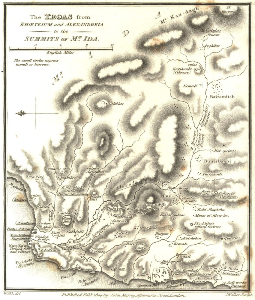
The Troas from Rhœteium and Alexandreia to the Summits of Mᵗ. Ida.
W.M.L. del. Published Febʸ. 1824 by John Murray Albemarle Street London. J. Walker Sculpt.
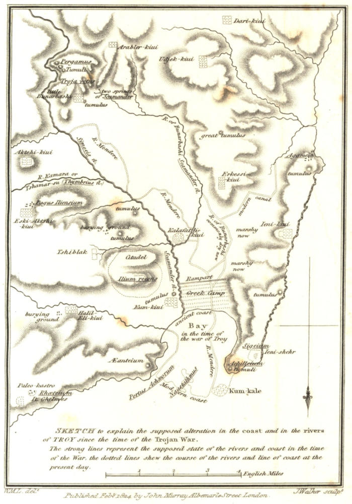
Sketch to explain the supposed alteration in the coast and in the rivers of TROY since the time of the Trojan War.
The strong lines represent the supposed state of the rivers and coast in the time of the War. The dotted lines shew the course of the rivers and line of coast at the present day.
W.M.L. delᵗ. Published Febʸ. 1824 by John Murray Albemarle Street London. J. Walker sculpᵗ.
The most remarkable places in the Troas were Assus, Lectum, Hamaxitus, Larissa, Colonæ, Alexandreia, Cebrene, Neandria, Cenchreæ, Scamandria, Sigeium, and New Ilium.
The two most important, and to which the greater part of the population of the others was drawn as early as the time of the successors of Alexander, were Alexandria and New Ilium; and these continued to be the chief towns under the Roman emperors. Alexandria has preserved considerable remains to this day. Of New Ilium only the foundations of the walls with a few other fragments are to be seen.
As Hamaxitus, Larissa, and Colonæ, were from their proximity to Alexandria absorbed by that city at the time of its foundation[424], we are not surprised that no remains of them have been remarked by travellers. Some circumstances, however, mentioned by Strabo[425], are sufficient very nearly to fix their positions. Hamaxitus in particular is determined by the salt-works of Tragasæ, which are still in a state of operation on the sea-coast near the mouth of the river of Tuzla. This river (perhaps the ancient Satnioeis) does not, however, take its name, which means salt, from the maritime salt-works alone: there are other salt-works at some very copious sources of hot salt water, at a considerable distance from the sea, on the northern side of the valley, where is a village called Tuzla, and where the neighbouring hills are composed of rock salt. This curious fact accounts for the name Halesium, anciently applied to the district[426].
As it appears from Strabo that Cebrenia bordered on the territories of Antandrus, Hamaxitus, Neandria, New Ilium, and Scepsis[427], and that the Scepsia was on the Æsepus[428], consequently on the eastern side of the summit of Ida,—Cebrenia seems to have occupied the higher region of Ida on the western side, and its city very probably stood at Kushunlú Tepe, not far from Bairamitsh, where Dr. E. D. Clarke, proceeding from the latter place towards the sources of the Mendere and the summit of Ida, found very considerable remains of antiquity. The fine valley which extends from thence to the modern town of Ene, seems to answer in its upper part to the level country of Cebrenia, mentioned by Strabo[429]; and in its lower or western to the plain called Samonium, which belonged to Neandria[430]: for Neandria being described by the geographer as inland from Hamaxitus towards New Ilium, and as 130 stades distant from the latter[431], corresponds exactly in position with Ene.
In the plain of Troy, or region watered by the lower course of the Mendere and its branches, the only positions proved to be ancient sites, by remains of buildings existing in their original places, are—
1. That of New Ilium on a hill which rises to the eastward of the villages of Kum-Kiúi and Kalafátli, about 5 miles to the S.E. of Kum-Kalé or the lower castle of the Dardanells, and three miles from the nearest shore. The vestiges of the walls of the citadel are to be traced on the summit of the height; and some of the buildings of the town, on the western slope and at the foot of the hill: but very little now remains in its place, the site being resorted to (as it probably has been ever since its abandonment), as to a stone-quarry, for the materials of modern constructions—whence we find all the villages, farms, and particularly the Turkish cemeteries of the surrounding country, full of the inscribed or decorated marbles of New Ilium. 2. Paleó Aktshi Kiúi. This, by its direction and distance from New Ilium, corresponds exactly with the Ἰλιέων κώμη, or village of the Ilienses, described by Strabo[432] as being 30 stades eastward of New Ilium towards Ida and Dardania. 3. Paleó-Kastro, near the Turkish village of It-ghelmés, on a height overlooking the Bosphorus. This is probably the site of the town Rhœteium, on a part of the sea-shore of which was the Æanteium or tomb of Ajax[433], still existing. 4. Yenishehr, the ancient Sigeium. 5. Another Paleó-Kastro, near the mouth of the small river which receives the canal derived from the river of Bunárbashi. This has been supposed, with great probability, to have been a small town and port called Agameia[434]. 6. The hill which rises above the less or lower Bunárbashi to the S.E., and which is bounded in the same direction by the deep valley of the Mendere. This, it is not improbable, was the site of Scamandria; for it may be presumed that Scamandria being named by Pliny together with New Ilium[435], was in some part of the lower plain of the Scamander, near that river; and there is no site on the Mendere so remarkable as that of Bunárbashi. Pliny describes Scamandria as a small town: but it seems from an extant inscription to have been of sufficient importance to make a recorded treaty with New Ilium concerning the sale of corn[436].
The same heights are by many persons supposed to have been in an earlier age the position of the renowned capital of Ilus and his successors: indeed, so many of the most intelligent travellers[437] in the Troas are agreed in placing the Homeric Ilium at Bunárbashi, that I should have been satisfied on the present occasion with stating my concurrence with their opinion, and with referring to the arguments of such of them as have supported it by their publications, had not some adverse systems been recently maintained with great learning and ingenuity; though chiefly, it must be admitted, by those who have considered the question in the closet only. I shall here offer, therefore, a few observations on this subject; first stating what appear to me to be the strongest grounds for thinking that Bunárbashi was the site of Troy, and then the principal objections that have been made to that opinion, together with the arguments which occur in reply to them[438].
As even the identity of the country on the Asiatic side of the entrance of the Hellespontine strait with the scene of the Ilias has been doubted, it may not be useless to premise, that if the war of Troy was a real event, having reference to a real topography (and to doubt it would shake the whole fabric of profane history), no district has yet been shown that will combine even a few of the requisite features of the plain of Troy, except that between Kum-Kalé and Bunárbashi: whereas in that district, and in the surrounding country by land and by water, we find the seas and mountains and islands in the positions which the poet indicates, and many of them with the same or nearly the same names. The features which do not accord so well with his description are those which are the most liable to change in the lapse of ages,—the course and size of the rivers, and the extent and direction of the low coast where these waters join the sea. Instead of a river with two large branches, which Homer seems to describe, we find on one side of the plain a broad torrent, reduced in the dry season to a slender brook, and a few stagnant pools; and on the other side a small perennial stream, which instead of joining the former is diverted into an artificial channel, and is thus carried to a different part of the coast. But the diminutive size of some of the most celebrated rivers of antiquity is well known to those who have travelled in Greece; and it must be considered that a poet writing of a real scene is obliged to magnify those features, which without exaggeration would be beneath the dignity of his verse. In regard to the course of the streams, it seems sufficient still to find, at the end of three thousand years, two rivers which, if they do not now unite, evidently did so at a former period of time: and for the sources of that stream which Homer describes as rising under the walls of Troy, to find some very remarkable springs, not very different in their peculiarities from the poet’s description, and rising at the foot of a commanding height on the edge of the plain.
For poetry this coincidence appears sufficient: and in regard to the position of Troy itself, it seems enough to find a hill rising above the sources just mentioned, not only agreeing in all particulars with the kind of position which the Greeks[439] usually chose for their towns, but the only situation in this region which will combine all the requisites they sought for; namely, a height overlooking a fertile maritime plain,—situated at a sufficient distance from the sea to be secure from the attacks of pirates, and furnished with a copious and perennial supply of water,—presenting a very strong and healthy position for the city; and for the citadel a hill beyond the reach of bowshot from the neighbouring heights, defended at the back by steep rocks and precipices, surrounded by a deep valley and broad torrent, and backed beyond the river by mountains which supplied timber and fuel. That it was precisely such a situation as the inhabitants of Greece and Asia in remote ages preferred, might be shown by a great variety of examples: and it can hardly be doubted that a person totally unacquainted with the Ilias, but accustomed to observe the positions of ancient Greek towns, would fix on Bunárbashi for the site of the chief place of the surrounding country.
It is a necessary consequence of placing Troy on the heights to the S.E. of Bunárbashi, that the river flowing from the sources which give that village its name (meaning Spring-head), is the Scamander of Homer: that the large torrent which flows through a deep ravine on the eastern side of the heights, is the Simoeis: and that notwithstanding the much greater magnitude of the bed of the latter and occasionally of that stream itself, the united river after the junction in the plain was called by the name of the former, Scamander. In support of this opinion, it has been justly observed by Lechevalier, that Homer’s description, allowance being made for poetical exaggeration, is correct, both as to the springs themselves, and as to the very different character of the two rivers: nor can it be denied that the two hills, that of Bunárbashi and the higher eminence behind it, correspond to the mention by Homer of Ilium and its citadel Pergamus. The termination of the slope towards the springs accords also with the idea which we receive from the poet of the extent of the city on that side, and of the position of the gate Scææ or Dardaniæ, which was near the sources of the Scamander, and was the principal outlet towards the plain[440]. But if these assumptions are not unreasonable, it cannot be denied on the other hand that in attempting to identify such objects as the tombs of Ilus, Myrinna, and Æsyetes, Lechevalier has exposed himself to reasonable objections from his opponents, and has rather injured than strengthened his cause. For it is not certain that all the monuments mentioned by Homer were tumuli; and it is very possible that if they were, several of them have been obliterated by time. Nothing can be more likely than that the real history of the monuments should have been forgotten in the interval between the destruction of Troy and the foundation of New Ilium, and that names should have been ascribed to them by the inhabitants of the latter place, suited to their own system of Trojan topography, and favourable to the pretensions which they held, that their city stood upon the ancient site. With regard to the existing barrows, it seems incontrovertible only that those which stand in conspicuous situations on either side of the mouth of the Scamander, are the tumuli, supposed in the time of the Romans, and probably with reason, to have been the sepulchres of Ajax, Achilles, and some other chieftains; and these monuments are so far important, as they prove the identity of the plain of the Mendere with the scene of the Ilias[441].
It is objected to the springs of Bunárbashi, that instead of being only two,—one hot and the other cold, as described by Homer[442],—they are in one place so numerous as to have received from the Turks the name of Kirk-Ghiuz, (the Forty Fountains), and that they are all of the same temperature.
But viewing them as the springs of a river, they may in poetical language, or even in common speech, be considered as two, since they arise in two places, distant from each other about 200 yards: in one the water appears in a deep basin, which is noted among the natives for being often covered with a thick vapour like smoke: in the other place, there are numerous rills issuing from the rocks, into a broad shallow piece of water, terminating in a stream which is joined by that from the smoking spring. As to the temperature of the water, the observations of travellers give various results. Some have observed a difference: according to others, it would appear that being all deep-seated springs, their temperature is the same at all seasons, or about 60° of Fahrenheit at their eruption from the ground; consequently that they will feel cold when the air is at 70° or 80°, and warm when it is at 40° or 50°[443]. But even in this case it is obvious that there will be a real difference between the heat of the shallow recipient of the springs called the Forty Fountains, and that of the single deep pool. It seems sufficient to justify Homer’s expression, that a difference of temperature was believed, and that an occasional appearance of vapour over one source was often observed by the natives: for the poet would probably flatter the local prejudices, even if he had examined the fountains so attentively as to be convinced that the warmth of all the sources was the same.
Another and a more weighty objection to the placing of Troy on the heights of Bunárbashi, is that the much greater magnitude of the river, which flows on the east side of those heights, concurs with its modern name Mendere in showing it to be the Scamander of Homer; and that such was evidently the opinion of several authors of antiquity, particularly of Demetrius, a native of Scepsis in the Troas, from whom Strabo principally derived his information on the geography of this district. In fact there can be no doubt, that in the time of Demetrius, who wrote in the second century before Christ[444], the Mendere from its source in Mount Kazdagh to its junction with the sea was called Scamander. But was it so in the time of the Trojan war? In this inquiry we have nothing to do with any authority but that of the Ilias itself: for it is evident from the remarks of Demetrius and Strabo, that the topography of the poem and the site of Troy were as much a subject of doubt and dispute in their time as they are at present. Nor is this surprising. The result of the Trojan war was the subversion of Ilium and the extinction (with the exception of a single branch of the royal family) of the colony which had settled in this part of Phrygia[445]. Strabo repeatedly remarks that the revolutions following the Trojan war were the great cause of the difficulty which he experienced in adjusting the Homeric chorography. The barbarous people of Thrace, called Treres, who then established themselves in the Troas, could not have taken much interest in any thing relating to the former colony, to whose language they were strangers, and whose history was recorded only in the songs of an Ionian stranger. It was not till long afterwards that the Æolian Greeks of Lesbus extended their settlements into the Troas. It was not even by them that New Ilium was founded, but by a Lydian, and consequently a semibarbarous colony[446], about the eighth century before Christ; and it was not till a taste for the poems of Homer having begun to prevail in European Greece, and the Athenians having taken possession of Sigeium[447] and a part of the Chersonesus, that their enlightened sovereigns Pisistratus and his sons[448], if they were not the first to collect, arrange, and edit the Ilias,—were at least the first to bring it into notice among the most lettered of the European Greeks[449]. We cannot wonder that the Homeric topography should at that time have become subject to the same kind of uncertainty now found to prevail in regard to such places as Athens, Rome, Jerusalem, Alexandria of Egypt, and even many cities much more modern.
For the New Ilium founded by the Lydians, colonized afterwards by the Æolians, and augmented and first fortified with a circuit of forty stades by Lysimachus[450], a situation was chosen which, being nearer to the sea than that of the ancient city, was better adapted to the more advanced state of commerce and civilization[451]. It was very natural that its inhabitants the Ilienses[452] should pretend that their town stood on the site of the ancient city[453]; and no less so, that a historian of a neighbouring and kindred race should flatter them by concurring in their opinion[454]. That the conquerors of Asia likewise, and so many other illustrious visitors of Ilium from Xerxes to the Cæsars, when they found it useful to their purposes or grateful to their vanity to sacrifice to Minerva Ilias, should have willingly followed the guidance of the priests to the temple in New Ilium, and should have admitted without inquiry that it stood on the site of the Pergamus of Priam—is nothing more than we should expect under such circumstances. But we know that the claim of the Ilienses was strongly contested during the whole period in which their city flourished. Demetrius of Scepsis and Hestiæa of Alexandria Troas opposed it about the time of the Antiochian war, and Strabo subscribed to their opinion in the Augustan age[455].
Although Demetrius found it impossible to assent to the claim of the Ilienses in this respect, and seems to have been far from implicitly believing in the identity of all the Homeric places pointed out by them[456]; he appears never to have suspected that the Scamander was any other than the large torrent, to which he found that name then applied from its mouth in the Hellespont to its distant source in the summit of Ida called Cotylus[457]. It was a necessary consequence (as all those who have concurred in the same belief have experienced) to identify the Simoeis with one of the branches of the Mendere flowing from the eastward. The Ghiumbrek-su, the most important of the Trojan streams after the Mendere and Bunárbashi river, seems to have been that which Strabo (probably following Demetrius[458]) supposed to be the Simoeis, as may be inferred from his observation that the site of Troy, which he places at the Pagus Iliensium (Paleó Aktshi), was near the river Thymbrius; and that the temple of Apollo Thymbræus at the junction of this river with the Scamander, was 50 stades from New Ilium[459]; for these data concur in showing that the Kamára-su[460] was the Thymbrius, and consequently that the Ghiumbrek-su was the Simoeis of the geographer.
But although a site had been found for Troy at Pagus by those who did not subscribe to the claims of the Ilienses in favour of their own site, neither Demetrius nor Strabo was able to discover any springs corresponding to the Scamandrian sources of Homer. Demetrius, having observed how utterly irreconcileable the single source of the Scamander in the distant summit of Mount Ida is with Homer’s description of the Scamandrian springs, was under the awkward necessity of imagining that those fountains, wherever they might be, were called the springs of Scamander, not as being in reality the sources, but only because they were near the Scamander, or because they afforded a stream which joined that river[461]. And as the valley and river of Ghiumbrek do not unite with the plain and river of the Mendere till very near the sea, Demetrius distinguishes the Simoeisian from the Scamandrian plain[462]—a distinction, it may be observed, which no where occurs in Homer, and is in fact inconsistent with his topography.
There seems no other mode of obviating these difficulties, inevitably attendant upon taking the Mendere in its whole course for the Homeric Scamander, but to suppose that the river of Bunárbashi was the ancient Scamander, that it gave name to the united stream, and that the part of the Mendere above the junction was the Simoeis. The latter name appears to have become obsolete during the ages in which the events of the war of Troy had been almost forgotten on the scene itself, and in the time of Demetrius and Strabo to have been known only to antiquaries inquiring into the topography of the Ilias. The name of Scamander on the other hand, being the more illustrious of the two, and a name apparently of familiar import in Asia Minor[463], was retained in use: but as the river of Bunárbashi had lost much of its local importance, and had now become of inferior consideration, the name of Scamander before attached to the united stream and to the Bunárbashi-su, was after the revival of New Ilium by Lysimachus (and perhaps long before that time) applied to the united stream and to the whole course of the Mendere.
In some of the preceding pages we have had occasion to remark in the instances of the Sangarius, Mæander, and Hermus, how easily the names of two branches of a river are confounded with one another or with the united stream, and how readily they are transferred from the one to the other. In addition to these examples, it may be observed that a similar transmutation of name in two branches of the same river, under circumstances which cannot so easily be accounted for as in the Trojan rivers, is to be found in Thessaly, where the river called by Herodotus and Thucydides Apidanus, is undoubtedly the same as the Enipeus of later writers, whose Apidanus is at twelve miles distance, and joins the other branch not far from the confluence of the united stream with the Peneus.
The principal causes of the obscurity into which the Homeric Scamander (or river of Bunárbashi) had fallen at the time of Demetrius, are sufficiently manifest. When Troy stood at Bunárbashi, it was natural that the river which had its sources under the walls should be one of the deified rivers of the district. In the climate of Greece a perennial fountain, however small, was held in at least equal honour with a large torrent affording only water that was either turbid or stagnant: and we find many proofs in ancient history, and upon ancient monuments, especially coins, of the importance often attached to streams, however diminutive, which flow near the sites of large cities. It is not surprising, therefore, that the river, which from the position of its sources and from its utility was more peculiarly the river of Troy, should, while Troy flourished, have had a preference over the broad torrent in giving name to the united stream; or that its local importance should have ceased when the capital of the district was removed to a situation nearer the sea.
But besides these accidental causes, there were others arising from physical changes which tended to destroy the importance of the river of Bunárbashi. The Mendere and its tributary streams, which flow from Aktshi-Kiúi, from the Kamára valley, from Tshiblak and from Ghiumbrek, being all torrents descending from lofty mountains, bring down with them a great quantity of stones, earth, and other matter: while the Bunárbashi stream, deriving all its water from pure deep-seated veins, has little or no deposit. Hence during the ages which have elapsed since the Trojan war, the eastern side of the plain has been gradually rising; the course of the Mendere has been gradually receding from that side[464], and the western side has become more and more marshy; until at length the Bunárbashi, instead of uniting with the Mendere about the middle of the plain, as in the time of the Trojan war, is now forced to find its way through the marshes on the western side, and from those marshes into the Mendere by two exits not far from Kum-Kale, or towards the ancient Sigeium. Its waters in the plain have been still further diminished by a canal, which carries off a large portion of them into another stream, which joins not the Hellespont, but the Ægæan, at a part of the coast situated not less than seven miles from the ancient mouth of the Scamander. Whether this canal is the remains of an ancient work made for the purpose of draining the plain, when it became marshy by the operation of the causes above stated, or whether it was formed by the Turks merely for its present use, of turning some mills, may be doubtful: its effect has been to cut off in summer all communication between the Bunárbashi springs and the marshy ground on the western side of the plain; so that it is only in rainy seasons that the old bed of the river, which is still very traceable, is now filled with water. I shall here take occasion to remark, that the manner in which the alluvion collects in this plain, as already described, will account for an apparent difficulty in regard to those passages of the Ilias which shew that the Scamander (the united stream) flowed on the left of the Grecian encampment, or toward Rhœteium[465], instead of towards Sigeium, as might be inferred from Strabo[466] and present appearances: for it is evident from the causes mentioned, that the altered course of the river would be to the westward of the former course; and consequently that when there was a bay at the mouth of the Scamander, the river probably issued into that bay, not towards its western, but towards its eastern side[467]. No appearance of a bay indeed is now visible; but its former existence is undoubted, as well from the testimony of Homer as from the physical structure of the land. Instead of two promontories with a beach between them, as described by the poet, there is now only one low point of land, which has been formed between the two ancient capes by the soil brought down from the upper country by the river, and deposited at its mouth in the course of ages. The rate at which the new land has accumulated may be inferred from Strabo and Pliny, from whom it appears that in their time New Ilium was distant about a Roman mile and a half from the nearest shore[468]. Now it appears from the existing vestiges of New Ilium, by those of its citadel on the summit of the hill of Paleó Kastro, which rises behind Kalafatli, and Kum Kiui, and by other remains on the western slope of that hill,—that the lower part of the town reached nearly to the position of Kum Kiui, which is three miles from the shore, or more than double the distance assigned by Strabo. Allowing therefore the same rate of accumulation between the Trojan war and the Augustan age, as since that period, it becomes probable that in the former age the sea reached to about half a mile below the position of Kum Kiui: and consequently that Hestiæa of Alexandria was nearly correct in supposing that all the plain below the hill of New Ilium had been gained from the sea since the time of the Trojan war[469],—the sandy ground at the extremity of the slope of that hill, which gives name to Kum Kiui (Sand-village), marks perhaps what was at one period the sea beach. To those who may think this formation of new land over-rated[470], it is to be observed, that in every instance in which the history of Greece has left us the means of comparison, the same phenomenon has occurred in the maritime plains; and that in the instances of the Spercheius and Mæander, but particularly of the latter, the soil has been formed in the same period of time with a much greater rapidity.
From all these considerations, therefore, it seems highly probable that the mouth of the Scamander in the time of the Trojan war was not far from the situation now occupied by the village of Kum Kiui, and that the river of Bunárbashi or Scamander, instead of then creeping along the foot of the southern and western heights, crossed the plain from near Erkessi in the direction of Kum Kiui, and that it joined the Mendere or Simoeis towards the middle of the plain, perhaps not far from the present village of Kalafatli. The passages of the Ilias in which the πόρος, or ford of the Scamander is mentioned, tend to show that such must have been the course of the river, if Troy stood at Bunárbashi; and we have seen that the nature of the plain, and the manner in which the alluvion has been accumulated, render such a state of the river in ancient times highly probable.
A third objection to Bunárbashi as the site of Troy is, that its distance from the Grecian station at the mouth of the Scamander is so great as to render impossible some of the events of the Ilias. In considering this distance, however, we must first deduct from the actual distance of Bunárbashi from the nearest shore, the new land formed since the Trojan war, together with the depth of the Grecian encampment, which in length extended from the foot of the hill of Achilleium on the right, to the mouth of the Scamander on the left. The new land we have already seen to have been nearly all that which now lies below Kum Kiui. The following are the only circumstances upon which we may build a judgement as to the extent of the Grecian encampment.
According to the poet, the bay was too narrow to contain the whole fleet, which was therefore arranged in several lines[471]. Although nothing but necessity could have made the Greeks submit to having any of their vessels at a distance from the sea, and that we may therefore suppose the number of lines to have been as few as possible, the poet’s expression will hardly allow the supposition that there were fewer than four or five lines. And this number agrees very well with the dimensions of the ground: for if we allow 25 feet for the breadth of each ship, added to the interval between it and the next, we shall find that about one-fifth of 1200, which is the amount of Homer’s enumeration[472], would have been sufficient to occupy the space of one mile and a quarter, to which the rear of the Greek encampment was confined by the hill of Achilleium on the right, and by the river on the left, supposing its mouth to have been near Kum Kiui[473].
For the breadth or depth of the encampment it would not be necessary to assign more than three or four hundred yards, if it were measured only by the length of the ships, added to the necessary interval between the rows: but it is obvious that a large space must, either in the length or depth of the encampment, have been required for the tents of the leaders, for the chariots and horses, for the market, and for the places to contain the cattle and other commodities which the Greeks collected for provisions, or to be exchanged for wine[474]. In short, for a permanent encampment of between 50,000 and 100,000 men[475], with a front of a mile and a quarter, a depth of not less than half a mile would be necessary. Such a space would not be greater than was required by the Romans for their encampments[476]; in which, although there was ample accommodation for the several departments of the army, there was no necessity for the space required in the camp before Troy, for the ships, and for some of the other incumbrances incidental to its permanence. On the one hand we can hardly restrict the Greek camp to a smaller space than I have mentioned, because it would have been insufficient to contain the ships and tents: on the other, a much larger can hardly be assigned; because the inconvenience of having any of the ships at a distance from the sea-shore would be a powerful motive for contracting the space towards the plain, and because the poet expressly states that the army was crowded[477].
In considering, therefore, the transactions of the Ilias, the present distance of Bunárbashi from the mouth of the Scamander must be diminished about three miles and a half, in order to give the distance between Troy and the Grecian rampart, which will thus be reduced to about six miles.
The events which have been considered most inconsistent with the distance of Bunárbashi from the Hellespont, are those occurring on the days called by Pope the 23d and 28th; the former day occupies the 2d, 3d, 4th, 5th, 6th, and the greater part of the 7th books of the poem; the 28th day extends from the beginning of the 11th to the middle of the 18th book.
On the 23d day the Greeks are drawn out, after their forenoon’s repast, in the plain lying between the rampart and the Scamander; and from thence they advance to the city, where, after the duel between Menelaus and Paris, the armies join battle with alternate success. At one time the Trojans have so far prevailed as to have approached the Greek camp[478]; and at another, the Greeks are again near the city[479]. Hector then rallies his army; a duel ensues between him and Ajax, which is put an end to by the approach of night[480], and the Greeks retire to their encampment. It does not seem necessary to suppose that the ground passed over by the Greeks on this day is more than 20 or 22 miles; six of which were performed after the close of day.
On the 28th day the two armies drawn out in the plain before the Greek encampment, fought only with the light troops until the hour of the woodman’s meal[481], which, to judge by modern customs, was about 9 or 10 o’clock in the forenoon. The charioteers of the two armies having then come to action, the Greeks had the superiority, and beat back the Trojans quite to the walls of Troy[482], where Agamemnon being wounded, Hector in turn leads the victorious Trojans to the Grecian rampart, forces it, and fights at the ships. Patroclus then advances to battle in the armour of Achilles, and drives the Trojans back to the city. Here he is slain, and the Trojans again advance near to the Greek camp before the day closes[483]. As the movements on this day carry the parties quite up to the hostile fortifications, the distance passed over is in so much, but no more, greater than on the 23d day; and 24 miles seems to be the utmost distance that we are obliged to suppose the Greeks to have passed over on this day.
In considering the probability of these exploits, we must take into consideration that whatever may have been the proportion of the infantry to the chariots, the extreme distances appear to have been performed only by the latter; for Homer, in all the great movements from the Greek camp to Troy, and from Troy to the Greek camp, as well as in all the principal actions, notices the chariots only. Even in the assault of the wall, in the beginning of the 12th book, Hector descends from his chariot; and all the other Trojans, adds the poet, follow his example.
Not much argument, however, seems necessary against objections which, when allowed in their fullest force, are founded only on the exaggerations of a poet, to whom, however accurate as a geographer and historian when it was his object to be so, we cannot refuse the usual poetical liberties in some of the most animated descriptions which his work contains. If the labours of the Trojan and Grecian heroes in the two days the events of which are thought to disprove the position of Troy at Bunárbashi, were too great for ordinary men; they were not beyond the power of heroes who could hurl such rocks as two men in the time of the poet were unable even to lift[484]; who could make their voices heard from the centre to either extremity[485], or even from the one end to the other[486] of an encampment of sixty or eighty thousand men; and who could see so clearly, that Helen is able from the walls of Troy to point out and minutely describe all the leaders of the Grecian host, when the whole Trojan army lay between[487]. It is evident that these are fictions which the Muse allows and encourages; and instances of them are so frequent throughout the poem, that it cannot be necessary to make any more particular reference to them. At one time the poet found it convenient to magnify beyond probability, or even beyond possibility, the common occurrences of war; at another, to bring together the actions of an extensive field, in order to present them to view in one continued scene.
A fourth objection which has been made against the site of Bunárbashi is, that in this position it would have been impossible for Achilles to have pursued Hector three times round the walls of Troy, as Homer relates. But does Homer really so relate? It cannot be denied that many interpreters, ancient and modern, have understood the poet in this sense; and it is perhaps the most obvious meaning to a cursory reader, who does not particularly consider the fact described, or who has not, by a view of the site of Troy, been convinced of its extreme improbability. Virgil, however, who in the latter part of the 12th book of the Æneis, has very closely imitated every part of Homer’s description of the encounter between Achilles and Hector, seems to have understood his prototype very differently. He does not represent Turnus as pursued by his adversary round the walls of Laurentum, but as forming a circle in a plain which was bounded by those walls, by a marsh, and by the Trojan army. In like manner the pursuit of Hector by Achilles occurred in sight of the Trojans, collected on the ramparts on one side, and of the Grecian army drawn out in the plain on the other. And the poet, in describing the action, mentions no objects passed by Hector and Achilles, except the Scæan or Dardanian gate, the carriage-way under the walls, the Erineus, and the source of the Scamander[488]; all places which we know to have been on the side of the city towards the plain. Can it be supposed that Homer intended to describe the heroes as following such a track as must have concealed them entirely from the view of both armies, except in a small portion of the circle?
It has justly been observed by Lechevalier and Choiseul Gouffier that the word περὶ, which has given rise to the erroneous interpretation of this passage, means, in other passages[489] perfectly similar, near or before the city, and not around it. To this I may add, that no supposed situation of the city, which is not entirely in the plain, will suit the idea of a course round the entire circuit of the walls; and that such a situation would be totally unadapted to the description which Homer has given of Troy, as windy[490], lofty[491], and as surmounted with a citadel bordered by precipices[492]. Strabo in fact, following Demetrius, makes use of this very argument to prove that the ancient city did not stand at New Ilium; round which, he remarks, it would have been impossible for Achilles to have pursued Hector[493]. It would seem, therefore, that the poet, as a keen observer of nature, intended to describe that circular course, which a person invariably takes when he runs from another, and finds no shelter or advantageous position for defending himself. The track of the two heroes was from the Scæan gate, along the road under the walls, by the Erineus, and by the fountains of the Scamander back again to the Scæan gate. Ὣς οἳ τρὶς Πριάμοιο πόλιν περὶ δινηθήτην[494].
It remains to offer a few remarks in justification of the north-eastern portion of the map which accompanies the present volume. This part of Asia Minor was called Pontus by the Romans, from its bordering on the Euxine sea: though it still retained the divisions of its ancient inhabitants, the Bithyni, Maryandini, Caucones, and Paphlagones. Here, as in many other parts of the peninsula, modern travellers have not yet afforded us sufficient information to enable us to make the best use of the evidence of ancient history. The astronomical observations of M. Beauchamp and Capt. Gauttier have been of great importance in giving the correct length of the coast, its general outline, and the exact position of the principal places: but it requires such a careful survey as that of the southern coast by Capt. Beaufort, to illustrate fully the three ancient Periplus of the Pontic coast[495], and to correct the numerical errors which their disagreement with one another proves to exist in them.
On the sea-coast all the most important sites of antiquity are determined by the actual names.—These sites are Rhebas, now Ríva; Calpe, Kerpe; the river Sangarius, Sakaría; Heraclia, Erégri; the river Parthenius, Bartan, in Greek Parthéni; Amastris, Amásera; Cytorus, Kídros; Thymena, Temena; Carambis, Kerempe; Abonuteichus, afterward Ionopolis, Aináboli; Cinolis, Kinóli; Stephane, Istefán, in Greek Stéfanos; Sinope, Sinub, in Greek Sinópi; Carusa, Kerze; Amisus, Samsun. With these data it will not be difficult for the future traveller to fix the intermediate names of the three Periplus: especially as existing vestiges of antiquity, and the rivers which form a large proportion of the ancient names, will greatly facilitate the task.