GRAVEL AND SAND
Reading edition
Some 225,000 years ago, most of what is now Illinois was buried under the ice of the Illinoian glacier. Two earlier glaciers had covered large parts of Illinois, and another, known as the Wisconsinan glacier, came into the state later, about 50,000 to 70,000 years ago (fig. 16).
26
The relatively small glaciers in the United States today, such as those in the northern Rocky Mountains, are concentrated in valleys and are called valley glaciers. The glaciers that covered Illinois were parts of huge ice sheets that extended over much of the North American continent and are called continental glaciers. They spread over most of Canada, then pushed southward to bury New England and a great area in the north-central part of the United States north of the Ohio and Missouri Rivers.
Formation of Gravel and Sand Deposits
As the glacial ice edged slowly southward from Canada, it froze fast to and picked up soil and loose pieces of rock, with enormous force tore away huge chunks of bedrock, and mixed and ground these materials together (fig. 17).
Into Illinois the glacier carried rock materials from Canada, Wisconsin, Minnesota, and Michigan; other rock fragments were picked up in Illinois as the ice front advanced. When the glacier melted, it left behind its load of rock flour and rock fragments, much of it as a gray clay containing pebbles, cobbles, and boulders. Geologists call such deposits glacial till.
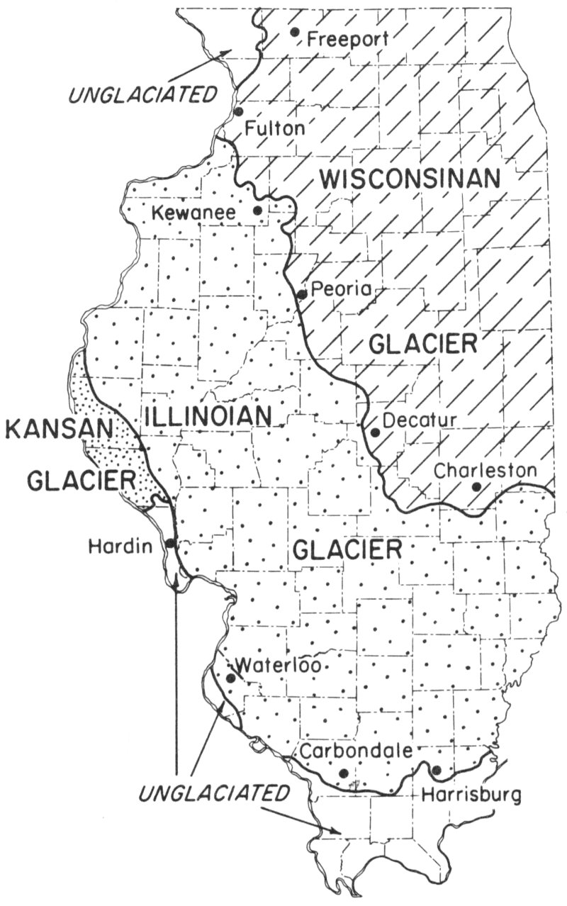
Figure 16—Extent of the exposed deposits of the Wisconsinan, Illinoian, and Kansan glaciers in Illinois, and the unglaciated areas of the state.
UNGLACIATED
WISCONSINAN GLACIER
Freeport
Fulton
Peoria
Decatur
Charleston
ILLINOIAN GLACIER
Kewanee
Waterloo
Carbondale
Harrisburg
KANSAN GLACIER
UNGLACIATED
Hardin
The ice in the continental glaciers usually crept forward, sometimes slowly, sometimes more rapidly. Whether the front of a glacier moved forward or back depended on the balance between the rate of forward motion of the ice and the rate of melting. When the ice advanced faster than it melted, the front of the glacier moved forward. 27 When the glacial ice melted faster than it moved forward, the front of the glacier receded. When the rates of melting and advance were about equal, the front of the glacier stood still or moved back and forth in a narrow zone.
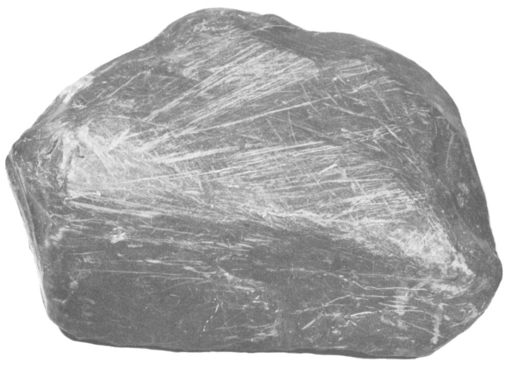
Figure 17—Striated boulder. Scratches and flattened surfaces were caused by abrasion by other rocks while boulder was embedded in glacial ice.
When such a more or less stationary front existed, an enormous amount of clay, silt, sand, pebbles, and boulders was deposited in a belt only a few miles wide along the front of the glacier, creating a line of hills and ridges that extended for many miles. Such belts, called end moraines, can be seen today in many parts of Illinois.
The building of end moraines often was accompanied by the release of great quantities of water (meltwater) from the melting ice. The water, laden with rock debris, flowed from the front of the glacier in many streams.
As the meltwater flowed away from the glacier it sorted its load, although the sorting was rarely perfect. The heavy boulders and pebbles usually were dropped first, then the sand, next the silt, and finally the clay. In general, the farther the deposits 28 were from the glacier the finer they were. The major streams frequently carried pebbles 50 to 100 miles from the glacier and it was many more miles before all the sand was dropped. They carried some of the fine silt and clay as far as the Gulf of Mexico.
Sometimes the floods of glacial water were greater and flowed faster than usual and so were able to carry coarse rock materials farther. As a result, gravel was laid down on top of earlier sand deposits. Later there may have been further sand deposition.
The debris-laden meltwater that flowed into valleys often deposited in them a considerable filling of sand and gravel. Some valleys were filled to a depth of as much as 100 feet. Such deposits are called valley fills or valley trains. Modern streams have cut their courses into many of these fills and even worn away large parts of them. Remnants of valley train deposits are now large terraces or benches along streams, many of them well above the present stream channels.
Where many small streams flowed from the glacier, they deposited sand and gravel as a large apron in front of the glacier. Such deposits are called outwash plains and many of them extend for miles.
Two other types of sand and gravel deposits made by glacial meltwaters also are significant. One was formed where water issued from the front of a glacier or poured into holes or crevasses in the ice. The sand and gravel in the water formed a deposit that now appears as a rounded hill associated with a terminal moraine and is called a kame. The second type of deposit was laid down in beds of streams flowing under, through, or on the glaciers and was left as a more or less continuous ridge of sand and gravel when the ice melted. Such a deposit is called an esker. Some eskers in Illinois are about a quarter of a mile wide and several miles long. Typical are the Kaneville Esker northwest of Aurora, the Adeline Esker south of Freeport, and the Exeter Esker west of Jacksonville.
The deposits of both the Illinoian and Wisconsinan glaciers are widely distributed throughout the state. Melting of the Illinoian glacier caused comparatively little flooding; consequently, extensive gravel deposits were formed in only a few places. The ice of the Wisconsinan glacier, however, melted rapidly and produced great floods laden with sand and gravel. Thus, most major gravel deposits in Illinois are related to the Wisconsinan glacier.
Wind sweeping across the sand and gravel deposits blew the sand into hills or sand dunes near such places as Havana, Prophetstown, Kankakee, and Watseka. Even today the wind shifts sand of long-forgotten glacial floods.
29
Studies of Glacial Deposits
The foregoing discussion of glaciers and their deposits is greatly simplified. For some time geologists of the Illinois Geological Survey have been mapping the moraines, valley trains, outwash plains, and other glacial deposits of the state. Because the Illinoian and Wisconsinan glaciers advanced and retreated several times, they built many moraines. The Survey has made a map (fig. 18) that shows the complexity of the moraines left by the Wisconsinan glacier. They are roughly concentric, indicating that the general shape of the glacier front remained about the same.
Principal Commercial Sources of Sand and Gravel
The sand and gravel industry is widely distributed throughout Illinois. The principal commercial sources of sand and gravel are valley trains and outwash plains. The Fox, Rock, Illinois, Mississippi, and Wabash Rivers and many smaller streams have terraces in their valleys that are parts of valley trains. In these deposits are some of the largest sand- and gravel-producing operations in the state.
Composition
An examination of glacial gravel deposits in Illinois reveals pebbles and larger pieces of many kinds of rock. Some are gray, others white, pink, brown, or black. They commonly include limestone, dolomite, granite, and many rocks with less common names such as quartzite, schist, and basalt. The limestone and dolomite were picked up by the glaciers from outcrops in northern Illinois, Wisconsin, and Michigan. Some of the granite pebbles resemble outcrops in Wisconsin; others look like granite that crops out in Canada. The quartzite probably came from Wisconsin, and black shale fragments found in some gravel deposits came from the floor of Lake Michigan or from western Michigan. Occasionally pieces of metallic copper are found that probably had their source in the Lake Superior copper-bearing area.
In addition to the sand associated with gravel deposits, extensive deposits of sand alone are found at many places in Illinois. Most of the sand grains are pieces of minerals that were constituents of rocks until weathering, the grinding action of the glaciers, and other erosive agencies broke the rocks into sand. The principal mineral in glacial sand is quartz, but many others occur in lesser amounts, including calcite, dolomite, feldspar, pyroxene, tourmaline, garnet, magnetite, and hornblende. Most of these are foreign to Illinois, although the calcite and dolomite may be native.
30
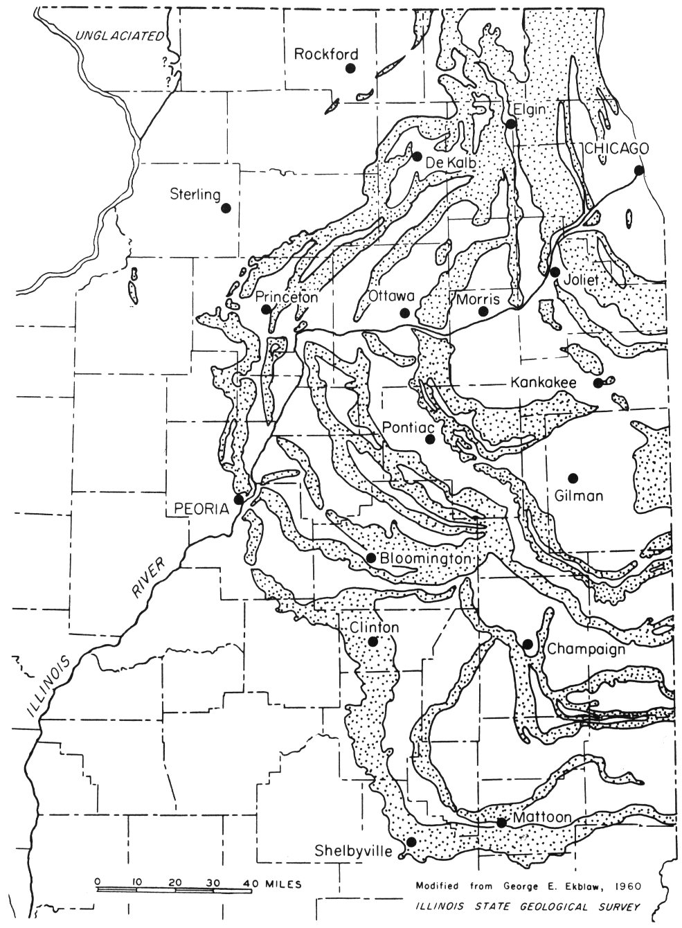
Figure 18—Moraines left by Wisconsinan glacier.
Modified from George E. Ekblaw, 1960
ILLINOIS STATE GEOLOGICAL SURVEY
31
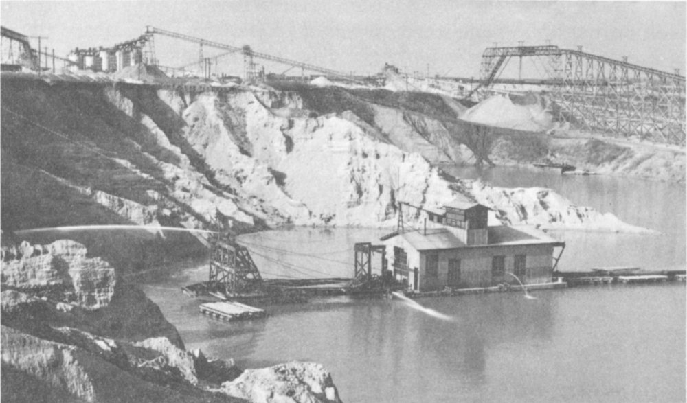
Figure 19—Gravel dredge, with plant for processing the gravel in background.
Uses of Sand and Gravel
In 1963 more than 27 million tons of sand and gravel, directly or indirectly of glacial origin, was sold by Illinois producers for almost 25 million dollars. The sand alone would have filled a child’s sand box, with an area of 8 square miles, to a depth of 1 foot. The gravel would have covered an even larger area.
The gravel was used in making concrete for roads and buildings, for surfacing roads, for ballast for railroad tracks, and for other purposes. The sand found its way into plaster, mortar, concrete, and a variety of other products and uses. Some of it was produced for use as molding sand.
Production of Sand and Gravel
The production of sand and gravel from its deposits may be a relatively simple operation or one of considerable complexity. Gravel for surfacing a road may be dug from a conveniently located pit and loaded mechanically into trucks that haul it to the road. A large sand- and gravel-producing operation, however, may include not only mechanical equipment to load and transport the material but also a processing plant where it can be washed if necessary and screened to various sizes.
32
In a “dry pit” operation, mechanical cranes or shovels pick up the gravel and sand and load it into trucks, railroad cars, or conveyor belts to be transferred to the processing plant. There clay and dirt may be washed out and the sand and gravel is sized by screens. Conveyor belts carry sand and gravel to the various processing operations and to storage bins or piles on the ground.
A “wet pit” operation produces sand and gravel from an artificial pond or lake. In some operations the sand and gravel is mined by a dredge that floats on the water (fig. 19). In some pits, a stream of water is directed from the dredge against the bank of gravel to wash the gravel into the lake. A large metal pipe at the front of the dredge slants down into the water and sucks up the sand and gravel from the underwater part of the deposit. The gravel, sand, and water is then pumped through a pipe at the rear of the dredge to the processing plant on the shore.
In some types of wet pit operations a large scoop or bucket operated from a crane on the shore, or by cables fastened to the shore, is used to dig sand and gravel from beneath the water.
Dredges are used to pump up sand and gravel from the beds of Illinois rivers, especially the Mississippi, Ohio, and Wabash.
The sand and gravel resources of many parts of the state have been mapped and studied by the Illinois Geological Survey, and work of this kind is continuing.