Chapter XIII
Arthur G. Chater translation
THE NORTH IN MAPS AND GEOGRAPHICAL WORKS OF THE MIDDLE AGES
At the beginning of the Middle Ages and down to the fifteenth century the cartography of the Greeks, which had reached its summit in the work of Ptolemy, was entirely unknown in Europe; while the early Greek conceptions (those of the Ionian school) of the disc of the earth or “œcumene” as a circle (called by the Romans “orbis terrarum,” the circle of the earth) round the Mediterranean—and externally surrounded by the universal ocean—had persisted through the late Latin authors, and probably also through Roman maps. At the same time Parmenides’ doctrine of zones (cf. vol. i. pp. 12, 123) remained prevalent owing to its enunciation by Macrobius, and maps exhibiting this doctrine were common until the sixteenth century. These two conceptions became the foundation of the learned view and representation of the world, and consequently also of the North, throughout the greater part of the Middle Ages. It was the age of speculation, not of observation. The Scandinavians were the first innovators in geography, by going straight to nature as it is, unfettered by dogmas. The Italian and Catalan sailors followed later with their portulans (sailing-books) and compass-charts.
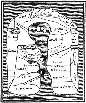
Map of the world from Albi in Languedoc, also called the Merovingian map (eighth century). The east is at the top,the Mediterranean in the middle, and the universal ocean outside, with its three bays: the Caspian Sea, the Persian Gulf and the Red Sea
Oldest mediæval maps The wheel-map type
We find what is perhaps the oldest known Christian map of the world (cf. vol. i. p. 126) in the “Christian Topography” of Cosmas Indicopleustes.[162] An attempt is made to combine the Roman classical view of the world, as lands grouped round the Mediterranean, with Cosmas’s pious conception of it as formed on the same rectangular plan as the Jews’ tabernacle. A map of the world of somewhat similar form is found in a MS. (by Orosius and Julius Honorius) of the eighth century, preserved in the library at Albi in Languedoc. But these attempts must be regarded as accidental. Typical of that time were the so-called wheel- or T-maps, the shape of which was due especially to Isidore Hispaliensis (cf. vol. i. pp. 151, ff.). The circular Roman maps of the world seem already to have had a tendency to a tripartition of the world: Europe, Asia and Africa. Sallust (in the “Bellum Jugurtinum”) indicates something of the sort, and Orosius’s geographical system seems to be founded upon a map of this kind. In St. Augustine we first find the division of the T-map clearly expressed. This dogmatic-schematic form was fixed by Isidore, according to whom the round disc of the earth surrounded by the outer ocean was to be compared to a wheel (or an O), divided into three by a T.[163] Mechanical map-forms after this prescription (cf. vol. i. pp. 125, 150) were common during the whole of the first part of the Middle Ages until the fourteenth century; indeed they circulated and exercised influence far into the sixteenth; but sometimes, in accordance with the four corners of the earth in the Bible, the maps were given a square form instead of a round. In spite of the fact that most authors, among them Isidore himself, expressly declare that the earth had the form of a globe, this does not seem to have been anything more than a purely theoretical doctrine, for in cartographical representations, through the whole of the Middle Ages to about the close of the fifteenth century, there is never any hint of projection, or of any difficulty in transferring the spherical surface of the earth to a plane, which had been so clearly present to the minds of the Greeks.
Larger Image
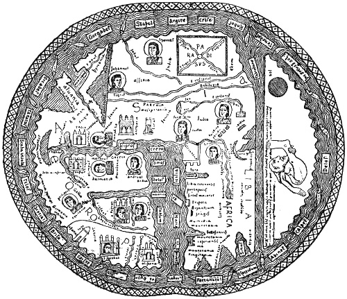
Beatus map, from Osma, 1203. The east is at the top
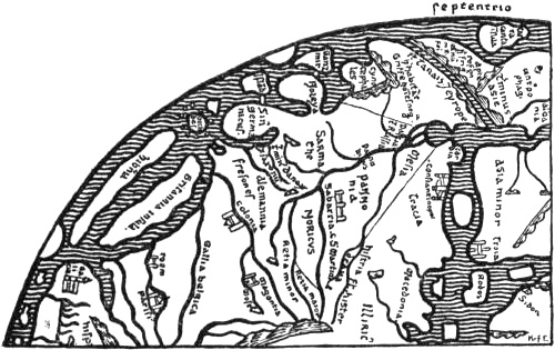
Northern Europe on Heinrich of Mainz’s map, at Cambridge (1110)
The Beatus map Sallust-maps
The wheel-maps were, as we have said, from the first purely formal; but by degrees an attempt was made to bring into the scheme real geographical information, although the endeavour to approach reality in the representation is scarcely to be traced. To this type of map belongs the so-called Beatus map, which the Spanish monk Beatus (ob. 798) added to his commentary on the Apocalypse, and which was reproduced in very varying forms, ten of which have been preserved. The original map, which is not known, was probably round, but in the reproductions the circle of the earth is sometimes more or less round (as in the illustration, p. 184), sometimes oblong (cf. vol. i. p. 199), and sometimes four-sided with rounded corners [cf. K. Miller, ii., 1895]. Jerusalem was frequently placed in the centre of the wheel-maps, Paradise (often with Adam and Eve at the time of the Fall, or with the four rivers of Paradise) in the extreme east of Asia, which is at the top of the map, and the Mediterranean (Mare magnum), which forms the stem of the T, pointing down (cf. vol. i. p. 150). The cross-stroke of the T was formed by the rivers Tanais (with the Black Sea) and Nile. In the band of ocean surrounding the disc of the earth the oceanic islands were distributed more or less according to taste, and as there happened to be room. Thus in the version of the Beatus map here given, from Osma in Spain (of 1203), Scandinavia appears as an island (“Scada insula”) by the North Pole, as in the Ravenna geographer (cf. the map, vol. i. p. 152), and the “Orcades” (the Orkneys) and “Gorgades” (the fabulous islands of the Greeks to the west of Africa) are placed on the north-east of Asia. The so-called Sallust-maps, drawn up from Sallust’s description of the world in the Bellum Jugurtinum [cf. K. Miller, iii., 1895, pp. 110, ff.], were another type of very formal wheel-maps that were still current in the fourteenth century.
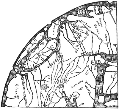
Northern Europe on the Hereford map (circa 1280)
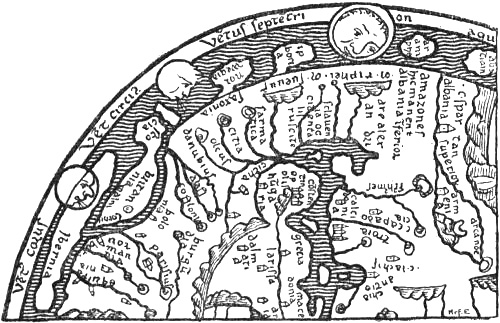
Northern part of the Psalter map (thirteenth century)
The North on known wheel-maps of the Middle Ages
But by degrees many changes were introduced into the strict scheme. The outer coast-line of the continents was in parts indented by bays and prolonged into peninsulas, and the islands were given a less formal shape. Such attempts appear, for instance, in Heinrich of Mainz’s map, which is taken to have been drawn in 1110 [cf. K. Miller, iii., 1895, p. 22], and the closely related “Hereford map” of about 1280 by Richard de Holdingham [cf. K. Miller, iv., 1896; Jomard, 1855]. Some resemblance to these maps is shown by the “Psalter” map in London, of the second half of the thirteenth century, and the closely related “Ebstorf” map of 1284 [cf. K. Miller, iii. pp. 37, ff.; iv. p. 3; v.]; and it is quite possible that they may all be derived from the same original source; there is in particular a great resemblance in their representation of Britain and Ireland. On the first three of these maps Scandinavia or Norway (“Noreya” or “Norwegia”) forms a peninsula with gulfs on the north and south sides. On Heinrich’s map there is beyond this an island or peninsula, called “Ganzmir,” a name which occurs again on the Hereford map (cf. vol. i. p. 157); Miller explains it as a corruption of Canzia, Scanzia (Scandinavia). On the “Lambert” map in the Ghent codex of before 1125 [cf. K. Miller, iii., 1895, p. 45], “Scanzia,” also with the name “Norwegia,” is represented as a peninsula with narrow gulfs running up into the continent on each side. “Island” (or “Ysland”) appears on Heinrich’s and the Hereford maps as an island near Norway. On the Ebstorf map “Scandinavia insula” and “Norwegia” are also shown as islands. Many fabulous countries, such as “Iperboria” (the land of the Hyperboreans), “Arumphei” (on the Psalter map, i.e., the land of the Aremphæans, cf. vol. i. p. 88), etc., appear as peninsulas or islands in the northern regions on several of these maps; on the other hand, neither Greenland nor Wineland occurs on any of them.
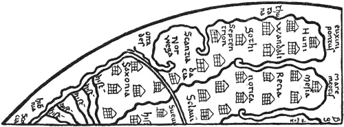
Northern Europe on the Lambert map at Ghent (before 1125)
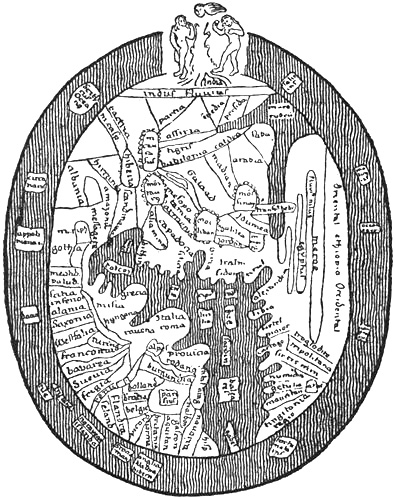
Ranulph Higden’s map of the world, in London (fourteenth century)
Higden’s work and the Geographia Universalis
Ranulph Higden’s map of the world, which accompanied his already mentioned work, “Polychronicon” (of the first part of the fourteenth century), is more fettered by the scheme of the wheel-maps in the form of the outer coast-line and of the islands. He took his vows in 1299, was a monk of St. Werburg’s Abbey at Chester, and died at a great age in 1363. Various reproductions of his map are known, but they display little sense of realistic representation. “Scandinavia” is placed in Asia on the Black Sea, together with the Amazons and Massagetæ, and to the north of it “Gothia” (Sweden ?). Islands in the ocean off the coast of northern Europe are called “Norwegia,” “Islandia,” “Witland” (or “Wineland,” etc.), with “gens ydolatra,” “Tile” (Thule) and “Dacia” (Denmark) with “gens bellicosa” somewhere near the North Pole. In spite of this representation on the map, the Polychronicon (cf. above, p. 31) contains various statements about the North, which may point to a certain communication with it, or may be echoes of Northern writers. Higden to a large extent copied an earlier work, the “Geographia Universalis,” a sort of geographical lexicon by an unknown author of the thirteenth century,[164] which is for the most part based on earlier writers, especially Isidore. Both works are practically untouched by the knowledge of the North that had already appeared in King Alfred and in Adam of Bremen, and show how much ignorance could still prevail in learned quarters on many points connected with these regions. The “Geographia” speaks of “Gothia,” or lower Scythia, as a province of Europe, but obviously confuses Sweden (the land of the Götar) and Eastern Germania (the land of the Goths). Norway (“Norwegia”) was very large, far in the north, almost surrounded by the ocean; it bordered on the land of the Goths (Götar), and was separated from Gothia (Sweden) on the south and east by the river Albia (the Göta river). The inhabitants live by fishing and hunting more than by bread; crops are few on account of the severity of the cold. There are many wild beasts, such as white bears, etc. There are springs that turn hides, wood, etc., into stone; there is midnight sun and corresponding winter darkness. Corn, wine and oil are wanting, unless imported. The inhabitants are tall, powerful and handsome, and are great pirates. “Dacia”[165] was divided into many islands and provinces bordering on Germania. Its inhabitants were descended from the Goths (Götar ? cf. Jordanes, vol. i. p. 135), were numerous and finely grown, wild and warlike, etc. “Svecia” (the land of the Svear) is also mentioned. That part of it which lay between the kingdoms of the Danes and of the Norwegians was called Gothia. Svecia had the Baltic Sea on the east and the British Ocean on the west, the mountains and people of Norway on the north, and the Danes on the south. They had rich pastures, metals and silver mines. The people were very strong and warlike, they once ruled over the greater part of Asia and Europe.
“‘Winlandia’ is a country along the mountains of Norway on the east, extending on the shore of the ocean; it is not very fertile except in grass and forest; the people are barbarously savage and ugly, and practise magical arts, therefore they offer for sale and sell wind to those who sail along their coasts, or who are becalmed among them. They make balls of thread and tie various knots on them, and tell them to untie three or more knots of the ball, according to the strength of wind that is desired. By making magic with these [the knots] through their heathen practices, they set the demons in motion, and raise a greater or less wind, according as they loosen more or fewer knots in the thread, and sometimes they bring about such a wind that the unfortunate ones who place reliance on such things perish by a righteous judgment.”
It is possible that the name “Winlandia” itself is a confusion of Finland (i.e., the land of the Finns [Lapps], Finmark) with Vinland (cf. above, p. 31); although the description of the country must refer to the former. It may be supposed that a misunderstanding of the name was the origin of the myth of selling wind being connected with it. The idea persisted, and the same myth is given so late as by Knud Leem [1767, p. 3] from an anonymous book of travels in northern Norway.
Of Iceland the “Geographia” says:
“‘Yselandia’ is the uttermost part of Europe beyond Norway on the north.... Its more distant parts are continually under ice by the shore of the ocean on the north, where the sea freezes to ice in the terrible cold. On the east it has Upper Scythia, on the south Norway, on the west the Hibernian Ocean.... It is called Yselandia as the land of ice, because it is said that there the mountains freeze together to the hardness of ice. Crystals are found there. In that region are also found many great and wild white bears, that break the ice in pieces with their claws and make large holes, through which they plunge down into the water and take fish under the ice. They draw them up through the said holes, and carry them to the shore, and live on them. The land is unfertile in crops except in a few places.... Therefore the people live for the most part on fish and hunting and meat. Sheep cannot live there on account of the cold, and therefore the inhabitants protect themselves against the cold and cover their bodies with the skins of the wild beasts they take in hunting.... The people are very stout, powerful, and very white (‘alba’).”
In Higden’s Polychronicon Gothia is also spoken of as lower Scythia, but among the provinces of Asia, although it is said that it lies in Europe; it has on the north Dacia and the Northern Ocean. But the geographical confusion in this work is greater; as already mentioned (p. 31), the countries of the Scandinavians are described together with the Insulæ Fortunatæ, Wyntlandia, etc., as islands in the outer ocean. The disagreement between Higden’s text and his map gives us an insight into how little weight was attached at that time to the relation between maps and reality; they are for the most part merely graphic schemes. Probably Higden’s map was partly copied from an older one, and the desirability of bringing it into better agreement with his text did not occur to him.
The Cottoniana map
The so-called “Anglo-Saxon mappamundi” or “Cottoniana” (reproduced vol. i. pp. 180, 183), which is in the British Museum, occupies a position of its own among early mediæval maps. Its age is uncertain; it may at the earliest date from the close of the tenth century, but possibly it is as late as the twelfth [cf. K. Miller, iii., 1895, p. 31]. It exhibits no agreement with the text of Priscian (Latin translation of Dionysius Periegetes, see vol. i. p. 114), to which it is appended. Many of the names might rather be derived from Orosius, there is also great resemblance to Mela (cf. vol. i. pp. 85, ff.), and in some ways to the mediæval maps already mentioned, although the representation of the North is different. Probably an older, perhaps Roman (?) map formed the basis of it. Name-forms like Island, Norweci[166] (Norwegia), Sleswic, Sclavi, may remind us of Adam of Bremen, but they may also be older. This map is doubtless less formal than the pronounced wheel-map type, but it does not bear a much greater resemblance to reality, although the form of Britain, for instance, may show an effort in that direction. The peninsula which has been given the name of Norweci (Norway) has most resemblance to Jutland, and the name seems to have been misplaced. No doubt it ought rather to have been attached to the long island lying to the north, which has been given the names Scridefinnas and Island. The representation has great resemblance to Edrisi’s map (cf. p. 203), where Denmark forms a similar peninsula, and Norway a similar long island, with two smaller islands to the east of Denmark, which is also alike. The “Orcades Insule” are given a wide extension on the Cottoniana map, and Tyle (Thule) lies to the north-west of Britain, as it should do according to Orosius. This map does not therefore indicate, any more than the others, any particular increase of knowledge of the North, and compared with King Alfred’s work it is still far behind in the dark ages.
Macrobius’s zone-maps
The zone-maps, already alluded to, which are derived from Macrobius (cf. vol. i. p. 123), gave a formal representation of the earth of a peculiar kind, which was common throughout the whole of the Middle Ages; they may be regarded as mathematical geography more than anything else. The earth is divided in purely formal fashion into five zones, two of which are habitable: our temperate zone and the unknown temperate zone of the antipodes (in the southern hemisphere); and three uninhabitable: the torrid zone with the equatorial ocean, and the two frigid zones, north and south. These conceptions also reached the North at an early time, and are mentioned in the “King’s Mirror,” amongst other works, although its author thought that the inhabited part of Greenland really lay in the frigid zone. A zone-map from Iceland is also known of the thirteenth century. Another of the fourteenth century and a kind of wheel-map of the twelfth century, but with geographical names only without coast-lines, are also found in Icelandic MSS., besides a small wheel- and T-map.[167] Otherwise it is not known that maps were drawn in the North during the Middle Ages. A purely formal wheel- and T-map is known from Lund before 1159 [see Björnbo, 1909, p. 189]. Another Danish wheel-map of the sixteenth century is known [see Björnbo, 1909, p. 192], and Björnbo reproduces [1909, pp. 193, ff.] two wheel-maps of 1486 from Lübeck, belonging to Professor Wieser, where the lands and islands of the North are drawn as round discs (with names) in the outer universal ocean.
THE ARAB GEOGRAPHERS OF THE MIDDLE AGES
The Arabs’ many connections
If we turn now from the intellectual darkness of Christian Western Europe in the early Middle Ages to contemporary Arabic literature, it is as though we entered a new world; not least is this shown in geographical science, where the authors follow quite different methods. Through their contact with the intellectual world of Greece in the Orient, the Arabs kept alive the Greek tradition; they had translations in their own language of Euclid, Archimedes, Aristotle, the now lost work of Marinus of Tyre, and others, and of special importance to their geographical knowledge was their acquaintance with Ptolemy’s astronomy and geography, which had been forgotten in Europe, and which first became known there through the Arabs (cf. vol. i. p. 116). They were also acquainted with Greek cartography. To this education in Greek views and interests was added the fact that they had better opportunities than any other nation of collecting geographical knowledge; through their extensive conquests and through their trade they reached China on the east—where for a considerable time their merchants had fixed colonies, first in Canton (in the eighth century), and later, in the ninth century, even in Khânfu (near Shanghai)[168]—and the western coasts of Europe and Africa on the west, the Sudan and Somaliland (and even Madagascar) on the south, and North Russia on the north. In spite of the religious fanaticism which in the seventh century made them an irresistible nation of conquerors, they had civilisation enough to remember that “the ink of science is worth more than the blood of martyrs,” and there flourished among them a remarkably copious literature, with an endless variety of works, from the ninth century through the whole of the Middle Ages.
The Arabs’ sense for geography
Although the Arabs never attained the Greeks’ capacity for scientific thinking, their literature nevertheless reveals an intellectual refinement which, with the dark Middle Ages of Europe as a background, has an almost dazzling effect. The Arab geographers have a special gift for collecting concrete information about countries and conditions, about peoples’ habits and customs, and in this they may serve as models; on the other hand sober criticism is not their strong side, and they had a pronounced taste for the marvellous; if classical writers, and still more the learned men of the European Middle Ages, had blended together trustworthy information and fabulous myth more or less uncritically, the Arabs did so to an even greater degree, and we often find in them a truly oriental splendour in the mythical; thus it must not surprise us to hear of whales two hundred fathoms long and snakes that swallow elephants in the same author (Ibn Khordâḏbah) who says that the earth is round like a sphere, and that all bodies are stable on its surface because the air attracts their lighter parts [thus we have the buoyancy of the air], while the earth attracts towards its centre their heavy parts in the same way as the magnet influences iron [a perfectly clear description of gravitation].
Chiefly on account of the language the new fund of geographical knowledge, which, together with much that is mythical, is contained in the rich literature of the Arabs, did not attain any great importance in mediæval Europe; on the other hand the Arabs exercised more influence through the geographical myths and tales which they brought orally from the East to Europe, and, as we have seen, the world of Irish myth, amongst others, was influenced thereby.
The Arabs’ connection with the North
The ideas of the Arabs about the North are, in most cases, very hazy. Putting aside the partly mythical conceptions that they had derived from the Greeks (especially Ptolemy), they obtained their information about it chiefly in two ways: (1) by their commercial intercourse in the east with Russia—chiefly over the Caspian Sea with the towns of Itil and Bulgar[169] on the Volga—they received information about the districts in the north of Russia, and also about the Scandinavians, commonly called Rûs, sometimes also Warank. (2) Through their possessions in the western Mediterranean, especially in Spain, they came in contact with the northern peoples of Western Europe, the Scandinavian Vikings (“Maǵûs”) in particular, and in that way acquired information.
“Maǵûs”[170] means in the west the same northern people, the Scandinavians, whom in the east the Arabs called Rûs or Warangs, which word they may have got from the Greek “Varangoi” (Βάραγγοι) and the Russian “Varyag.”
All that the Arab authors of the oldest period have about the North, and that is not taken from the Greeks, they got through their commercial connections with Russia; but it is not until the ninth century and later that anything worth mentioning appears, and even in the tenth and eleventh centuries their ideas on the subject are very much tinged with myth. Professor Alexander Seippel in his work “Rerum Normannicarum fontes Arabici” [1896], printed in Arabic, has collected the most important statements about the North in mediæval Arabic literature, and has been good enough to translate parts of these, which I give in the following pages. I have also made some additions from other sources. In an earlier chapter (pp. 143, ff.) several Arabic authors have already been quoted on the connection with Northern Russia.
The imperfection of Arabic script and its common omission of vowels easily give rise to all kinds of corruptions and misunderstandings; this is especially fatal to the reproduction of foreign words and geographical names, which explains the great uncertainty that prevails in their interpretation.
Ibn Khordâḏbah, A.D. 885
In the oldest Arab writers, of the ninth century and later, there is little or no knowledge of the North. We are only told in some of their works that furs come from there, and that the ocean in the north is entirely unknown. Abu’l-Qâsim Ibn Khordâḏbah (ob. 912), a Persian by descent and the Caliph’s postmaster in Media, thus relates in his “book of routes and provinces” (completed about 885):[171]
“As concerns the sea that is behind [i.e., to the north of] the Slavs, and whereon the town of Tulia [i.e., Thule] lies, no ship travels upon it, nor any boat, nor does anything come from thence. In like manner none travels upon the sea wherein lie the Fortunate Isles, and from thence nothing comes, and it is also in the west.” “The Russians,[172] who belong to the race of the Slavs [i.e., Slavs and Germans], travel from the farthest regions of the land of the Slavs to the shore of the Mediterranean (Sea of Rum), and there sell skins of beaver and fox, as well as swords” (?).
The Russian merchants also descended the Volga to the Caspian Sea, and their goods were sometimes carried on camels to Bagdad.[173]
Ibn al-Faqîh, 900 A.D. Ibn al-Bahlûl, 910 A.D. Qodâma
There was no great change in knowledge of the North in the succeeding centuries. Ibn al-Faqîh, about 900 A.D., has nothing to say about the North. He mentions in the seventh climate women who “cut off one of their breasts and burn it at an early age so that it may not grow big,”[174] and he says that Tulia (Thule) is an island in the seventh sea between Rumia (Rome) and Kharizm (Khwarizm in Turkestan), “and there no ship ever puts in.” Ibn al-Bahlûl, about 910 A.D., gives information after Ptolemy about the latitudes of the northern regions and mentions two islands of Amazons, one with men and one with women, in the extreme northern ocean [Seippel, 1896]. Qodâma Ibn Ǵafar (ob. 948 or 949 A.D.) says of the encircling ocean (the Oceanus of the Greeks) in which the British Isles lie that
“it is impossible to penetrate very far into this ocean, the ships cannot get any farther there; no one knows the real state of this ocean.” [Cf. De Goeje in Ibn Khordâdhbeh, 1889, p. 174.]
Ibn Ruste, 912 A.D.
Abû ‘Alî Ahmad Ibn Ruste, about 912 A.D., says of the Russians (“Rûs,” that is, Scandinavians, usually Swedes) that they live on an island, which is surrounded by a sea, is three days’ journey (about seventy-five miles) long, and is covered with forest and bogs; it is unhealthy and saturated to such a degree that the soil quakes where one sets foot on it. They come in ships to the land of the Slavs and attack them, etc. They have neither fixed property, nor towns, nor agriculture; their only means of support is the trade in sable, squirrel and other skins, which they sell to any one who will buy them. They are tall, of handsome appearance, and courageous, etc.[175] Probably there is here a confusion of various statements; the ideas about the unhealthy bog-lands are doubtless connected with northern Russia, and the trade in sables can scarcely be referred to the Swedes on the Baltic.[176]
Al-Mas’ûdî, before 950 A.D.
The well-known historian, traveller and geographer, Abu’l Hasan ‘Alî al-Mas‘ûdî (ob. 956), in his book (allegorically entitled “Gold-washings and Diamond-mines”) repeats certain Arab astronomers who say
“that at the end of the inhabited world in the north there is a great sea, of which part lies under the north pole, and that in the vicinity of it there is a town [or land] which is called Tulia, beyond which no inhabited country is found.” He mentions two rivers in Siberia: “the black and the white Irtish; both are considerable, and they surpass in length the Tigris and Euphrates; the distance between their two mouths is about ten days. On their banks the Turkish tribes Kaimâk and Ghuzz have their camps winter and summer.”
He also states that the black fox’s skin, which is the most valuable of all, comes from the country of the Burtâsians (a Finnish people in Russia, Mordvins ?), and is only found there and in the neighbouring districts. Skins of red and white foxes are mentioned from the same locality, and he gives an account of the extensive trade in furs, whereby these skins are brought to the land of the Franks and Andalusia [i.e., Spain], and also to North Africa, “so that many think they come from Andalusia and the parts of the land of the Franks and of the Slavs that border upon it.”[177] He also has a statement to the effect that before the year 300 of the Hegira [i.e., 912 A.D.] ships with thousands of men had landed in Spain and ravaged the country.
“The inhabitants asserted that these enemies were heathens, who made an inroad every two hundred years, and penetrated into the Mediterranean by another strait than that whereon the copper lighthouse stands [i.e., the Straits of Gibraltar]. But I believe (though Allah alone knows the truth) that they come by a strait [canal] which is connected with Mæotis [the Sea of Azov] and Pontus [the Black Sea], and that they are Russians [i.e., Scandinavians] ... for these are the only people who sail on these seas which are connected with the ocean.”[178]
This is evidently the ancient belief that the Black Sea was connected through Mæotis with the Baltic.
Al-Bîrûnî, 1030 A.D.
The celebrated astronomer and mathematician, Abu-r-Raihân Muhammad al-Bîrûnî (973-1038, wrote in 1030),[179] a Persian by birth, is of interest to us as the first Arabic author who uses the name “Warank”[180] for Scandinavian, and mentions the Varangians’ Sea or Baltic.
In his text-book of the elements of astronomy he says that from “the Encircling Ocean” [the Oceanus of the Greeks], out into which one never sails, but only along the coast, “there proceeds a great bay to the north of the Slavs, extending to the vicinity of the land of the Mohammedan Bulgarians [on the Volga]. It is known by the name of the Varangians’ Sea (‘Baḥr Warank’), and they [the Varangians] are a people[181] on its coast. Then it bends to the east in rear of them, and between its shore and the uttermost lands of the Turks [i.e., in East Asia] there are countries and mountains unknown, desert, untrodden.”
Al-Bîrûnî also has a very primitive map of the world as a round disc in the ocean, indented by five bays, of which the Varangians’ Sea is one [cf. Seippel, 1896, Pl. I]. The peoples who are beyond the seventh climate, that is, in the northernmost regions, are few, says he, “such as the Îsû [i.e., Wîsû], and the Warank, and the Yura [Yugrians] and the like.”
Al-Ġazâl’s voyage to the Maǵûs
The Arabs of the West came in contact with the North through the Norman Vikings, whom they called Maǵûs (cf. p. 55), and who in the ninth century and later made several predatory expeditions to the Spanish Peninsula. Their first attack on the Moorish kingdom in Spain seems to have taken place in 844, when, amongst other things, they took and sacked Seville. After that expedition, an Arab writer tells us, friendly relations were established between the sultan of Spain, ‘Abd ar-Raḥmân II., and “the king of the Maǵûs,” and, according to an account in Abu’l-Khaṭṭâb ‘Omar Ibn Diḥya[183] (ob. circa 1235), the former is even said to have sent an ambassador, al-Ġazâl, to the latter’s country. Ibn Diḥya says that he took the account from an author named Tammâm Ibn ‘Alqama (ob. 896), who again is said to have had it from al-Ġazâl’s own mouth. It is obviously untrustworthy, but may possibly have a historical kernel. The king of the Maǵûs had first sent an ambassador to ‘Abd ar-Raḥmân to sue for peace (?); and al-Ġazâl accompanied him home again, in a well-appointed ship of his own, to bring the answer and a present. They arrived first at an island on the borders of the land of the Maǵûs people.[184] From thence they went to the king, who lived on a great island in the ocean, where there were streams of water and gardens. It was three days’ journey or 300 [Arab] miles from the continent.
“There was an innumerable multitude of the Maǵûs, and in the vicinity were many other islands, great and small, all inhabited by Maǵûs, and the part of the continent that lies near them also belongs to them, for a distance of many days’ journey. They were then heathens (Maǵûs); now they are Christians, for they have abandoned their old religion of fire-worship,[185] only the inhabitants of certain islands have retained it. There the people still marry their mothers or sisters, and other abominations are also committed there [cf. Strabo on the Irish, vol. i. p. 81]. With these the others are in a state of war, and they carry them away into slavery.”
This mention of many islands with the same people as those established on the continent may suit the island kingdom of Denmark; but Ireland, with the Isle of Man, the Scottish islands, etc., lies nearer, and moreover agrees better with the 300 miles from the continent.
We are next told of their reception at the court of the king and of their stay there, and especially how the handsome and wily Moorish ambassador paid court in prose and verse to the queen,[186] who was very compliant. When Ibn ‘Alqama asked al-Ġazâl whether she was really so beautiful as he had given her to understand, that prudent diplomatist answered: “Certainly, she was not so bad; but to tell the truth, I had use for her....” When he was afraid his daily visits might attract attention, she laughed and said:
“Jealousy is not among our customs. With us the women do not stay with their husbands longer than they like; and when their consorts cease to please them, they leave them.” With this may be compared the statement for which Qazwînî gives aṭ-Ṭartûshi (tenth century) as authority, that in Sleswick the women separate from their husbands when they please [cf. G. Jacob, 1876, p. 34].
After an absence of twenty months, al-Ġazâl returned to the capital of the sultan ‘Abd ar-Raḥmân. In the excellence of its realistic description and the introduction of direct speeches this tale bears a remarkable resemblance to the peculiar method of narration of the Icelandic sagas.
Al-Idrîsî, 1154 A.D.
The best known of the western Arab geographers is Abû ‘Abdallâh Muḥammad al-Idrîsî (commonly called Edrisi), who gives beyond comparison the most information about the North. He is said to have been born in Sebta (Ceuta) about 1099 A.D., to have studied in Cordova, and to have made extensive voyages in Spain, to the shores of France, and even of England, to Morocco and Asia Minor. It is certain that in the latter part of his life he resided for a considerable time at the court of the Norman king of Sicily, Roger II., which during the Crusades was a meeting-place of Normans, Greeks and Franks. According to Edrisi’s account, Roger collected through interpreters geographical information from all travellers, caused a map to be drawn on which every place was marked, and had a silver planisphere made, weighing 450 Roman pounds, upon which were engraved the seven climates of the earth, with their countries, rivers, bays, etc.[187] Edrisi wrote for him his description of the earth in Arabic, which was completed in 1154, and was accompanied by seventy maps and a map of the world. Following the Greek model, the inhabited world, which was situated in the northern hemisphere, was divided into seven climates, extending to 64° N. lat.; farther north all was uninhabited on account of the cold and snow. Edrisi describes in his great work the countries of the earth in these climates, which again are divided each into ten sections, so that the book contains in all seventy sections.[188]
Larger Image
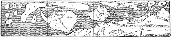
Edrisi’s representation of Northern Europe, put together, and much reduced, from eight of his maps. (Chiefly after Seippel’s reproduction [1896] and after Lelewel [1851].) Some of the Arabic names are numbered on the map and given below according to Seippel’s reading
(1) “Khâlia” (empty); (2) the first part of the 7th climate; (3) “ǵazîrat Birlânda” (the island of Birlânda, by a common error for Ireland); (4) “kharâb” (desert); (5) the island of “Dans” or “Vans” (Seippel reads Wales); (6) “ǵazîrat Angiltâra” (the island of England); (7) “ǵazîrat Sqôsia” (the island, or peninsula, of Scotland); (8) “al-baḥr al-muslim ash-shamâlî” (the dark northern ocean); (9) “ǵazîrat Islânda” (the island of Iceland); (10) “ǵazîrat Dânâmarkha” (the island, or peninsula, of Denmark); (11) “Hrsns” (Horsens); (12) “Alsia” (Als ?); (13) “Sliaswiq”; (14) “Lundûnia” (Lund); (15) “sâḥil arḍ Polônia” (the coast of Poland); (16) “Derlânem” (Bornholm ?); (17) “Landsu(d)den” (in Finland); (18) “Zwâda” (Sweden); (19) “nahr Qutalw” (the Göta river); (20) “ǵazîrat Norwâga” (the island of Norway); (21) may be read “Trônâ” (Trondheim); (22) “‘Oslô” (Oslo); (23) “Siqtûn”; (24) “bilâd Finmark” (the district of Finmark); (25) “Qalmâr”; (26) “Abûda” (Åbo ?); (27) “mabda’ nahr D(a)n(a)st” (the beginning of the river Dniestr ?); (28) “arḍ Tabast” (the land of Tavast); (29) “Daġwâda” (Dagö ?); (30) “ǵazîrat Amazânûs er-riǵâl al-maǵûs” (the island of the male heathen Amazons); (31) “ǵazîrat Amazânûs an-nisâ” (the island of the female Amazons)
On the outside of all is the Dark Sea [i.e., Oceanus, the uttermost encircling ocean], which thus forms the limit of the world, and no one knows what is beyond it. After describing Angiltâra [England] with its towns, Edrisi continues:
“Between the end of Sqôsia [Scotland], a desert island [i.e., peninsula],[189] and the end of the island of Irlânda is reckoned two days’ sail to the west. Ireland is a very large island. Between its upper [i.e., southern, as the maps of the Arabs had the south at the top] end and Brittany is reckoned three and a half days’ sail. From the end of England to the island of Wales (?)[190] one day. From the end of Sqôsia to the island of Islânda two-thirds of a day’s sail in a northern direction. From the end of Islânda to the great island of Irlânda one day. From the end of Islânda eastward to the island of Norwâga [Norway] twelve miles (?).[191] Iceland extends 400 miles in length and 150 in breadth.”
Dânâmarkha is described as an island, round in shape and with a sandy soil; on the map it is connected with the continent by a narrow isthmus. There are “four chief towns, many inhabitants, villages, well protected and well populated ports surrounded by walls.” The following towns are named: “Alsia” [Als ?], “Tordîra” or “Tondîra” [Tönder], “Haun” [Copenhagen], “Horsnes” [Horsens], “Lundûna” [Lund], “Slisbûlî” [Sliaswiq ?]. From “Wendilskâda,” written “Wadî Lesqâda” [Vendelskagen], it is a half-day’s sail to the island of “Norwâġa” [Norway]. An island to the east of Denmark and near Lund is called on the map “Derlânem” [Bornholm ?].
On the continent to the south of Denmark is the coast of “Polônia” [Poland], and to the east of it, also on the continent, is “Zwâda” [Sweden], and a town “Gûta” [Götaland], also “Landsu(d)den” [in Finland]. We have further the river “Qutelw” [the Göta river], on which is the town of “Siqtun.” There is also “Qîmia” [Kemi ?]. Farther east is “bilâd Finmark” [the district of Finmark],[192] where we still find the river Qutelw with the town of “Abûda” [Åbo ?] inland, and “Qalmâr” on the coast near another outlet of the Göta river. These two towns are
“large but ill populated, and their inhabitants are sunk in poverty; they scarcely find the necessary means of living. It rains there almost continually.... The King of Finmark has possessions in the island of Norwâġa.”
Next on the east comes the land of “Tabast” [Tavast] with “‘Daġwâda’ [Dagö ?], a large and populous town on the sea.” In the land of Tabast
“are many castles and villages, but few towns. The cold is more severe than in Finmark, and frost and rain scarcely leave them for a moment.”
Farther east Esthonia and the land of the heathen are also mentioned.
“As regards the great island of Norwâġa [Norway], it is for the most part desert. It is a large country which has two promontories, of which the left-hand one approaches the island of Dânâmarkha, and lies opposite to the harbour that is called Wendilskâda, and between them the passage is short, about half a day’s sail; the other approaches the great coast of Finmark. On this island [Norwâġa] are three inhabited towns,[193] of which two are in the part that turns towards Finmark, the third in the part that approaches Dânâmarkha. These towns have all the same appearance, those who visit them are few, and provisions are scarce on account of the frequent rain and continual wet. They sow [corn] but reap it green, whereupon they dry it in houses that are warmed, because the sun so seldom shines with them. On this island there are trees so great of girth as are not often found in other parts. It is said that there are some wild people living in the desert regions, who have their heads set immediately upon their shoulders and no neck at all. They resort to trees, and make their houses in their interiors and dwell in them. They support themselves on acorns and chestnuts. Finally there is found there a large number of the animal called beaver; but it is smaller than the beaver [that comes] from the mouth of Russia” [i.e., no doubt, from the mouths of the Russian rivers].
“In the Dark Sea [i.e., the outer encircling ocean] there are a number of desert islands. There are, however, two which bear the name of the Islands of the Heathen Amazons. The western one is inhabited solely by men; there is no woman on it. The other is inhabited solely by women, and there is no man among them. Every year at the coming of spring the men travel in boats to the other isle, live with the women, pass a month or thereabouts there, and then return to their own island, where they remain until the next year, when each one goes to find his woman again, and thus it is every year. This custom is well known and established. The nearest point opposite to these islands is the town of Anhô (?). One can also go thither from Qalmâr and from Daġwâda [Dagö ?], but the approach is difficult, and it is seldom that any one arrives there, on account of the frequency of fog and the deep darkness that prevails on this sea.”
Edrisi says that there are many inhabited and uninhabited islands in the Dark Sea to the west of Africa and Europe; indeed, according to Ptolemy “this ocean contained 27,000 islands.” He mentions some of them. There is an island called “Sâra,” near the Dark Sea.
“It is related that Ḏu’l-Qarnain (Alexander the Great ?) landed there before the deep darkness had covered the surface of the sea, and spent a night there, and that the inhabitants of the island attacked him and his companions with stones and wounded many of them [cf. the Skrælings’ attack in Eric the Red’s Saga, and the island of smiths in the Navigatio Brandani, vol. i. p. 328; vol. ii. p. 9]. Another island in the same sea is called the Isle of Female Devils (‘ǵazîrat as-sa’âlî’), whose inhabitants resemble women more than men; their eyeteeth protrude, their eyes flash like lightning, their cheeks are like burnt wood; they speak an incomprehensible language and wage war with the monsters of the ocean....”
He also mentions the Isle of Illusion (“ǵazîrat khusrân” == “Villuland,” cf. vol. i. p. 377), of great extent, inhabited by men of brown colour, small stature, and with long beards reaching to their knees; they have a large (broad)[194] face and long ears [cf. the ideas of the Pygmies, dwarfs, underground people and brownies], they live on plants that the earth produces of itself. There was a further large island “al-Ġaur,” with abundance of grass and plants of all kinds, where wild asses and oxen with unusually long horns lived in the thickets. There was the Isle of Lamentation (“ǵazîrat al-mustashkîn”), which was inhabited, and had mountains, rivers, many trees, fruits and tilled fields; but where there was a terrible dragon, of which Alexander freed the inhabitants. On the island of “Kalhân” in the same sea the inhabitants have the form of men but animal heads; another island was called the Isle of the Two Heathen Brothers, who practised piracy and were changed into two rocks. He also names the Island of Sheep and “Râka,” which is the Island of Birds (cf. pp. 51, 55).
“To the islands in this sea belongs also the island of ‘Shâsland’ [presumably Shetland, perhaps confused with Iceland], the length of which is fifteen days’ journey, and the breadth ten. It had three towns, large and populous; ships put in and stayed there to buy ambra (amber ?) and stones of various colours; but the majority of the inhabitants perished in dissensions and civil war which took place in the country. Many of them removed to the coast of the European continent, where large numbers of this people still live....”
What is here said about this island is approximately the same as Edrisi elsewhere states about the island of Scotland, following the “Book of Wonders,” which is attributed to Mas’ûdî.
It will be seen that he has a very heterogeneous mixture of islands in this western ocean. Some of them, like the Island of Sheep and that of Birds, as already suggested (p. 55), probably came from Ireland, and this whole archipelago is evidently related to the numerous islands of Irish legend, and points to an ancient connection, which may have consisted in reciprocal influence; while many of these conceptions travelled from the east through the Arabs to western Europe and Ireland, the Arabs again may have received ideas from the Irish and from western Europe and carried them to the east. Thus Edrisi relates that, according to the author [Mas’ûdî] of the “Book of Wonders,” the king of France sent a ship (which never returned) to find the island of Râkâ; we may therefore conclude that the Arabs had this myth from Europe. That many of these islands are inhabited by demons and little people, who resemble the northern brownies and the Skrælings, is interesting, and shows that whether the myths came from the Irish to the Arabs or vice versa, there were in this mythical world various similar peoples who may have helped to form the epic conceptions of the Skrælings of Wineland (cf. pp. 12, 75).
Edrisi’s map of the world is to a great extent an imitation of Ptolemy’s, but shows much deviation, which may resemble the conceptions of Mela, for instance. It might seem possible that Edrisi was acquainted with some Roman map or other. In his representation of the west and north coast of Europe, for instance, there are also remarkable resemblances to the so-called Anglo-Saxon map of the world (cf. vol. i. p. 183; vol. ii. p. 192); this may point to both being derived from some older source, perhaps a Roman map (?).[195]
Ibn Sa’îd, thirteenth century
Abu’l-Hasan ‘Alî Ibn Sa‘îd (1214 or 1218-1274 or 1286) says (in his book: “The extent of the earth in its length and breadth”)[196] of Denmark (the name of which he corrupts to “Ḥarmûsa”) that from thence are obtained true falcons (for hunting):
“Around it are small islands where the falcons are found. To the west lies the island of white falcons, its length from west to east is about seven days and its breadth about four days, and from it and from the small northern islands are obtained the white falcons, which are brought from here to the Sultan of Egypt, who pays from his treasury 1000 dinars for them, and if the falcon arrives dead the reward is 500 dinars. And in their country is the white bear, which goes out into the sea and swims and catches fish, and these falcons seize what is left over by it, or what it has let alone. And on this they live, since there are no [other] flying creatures there on account of the severity of the frost. The skin of these bears is soft, and it is brought to the Egyptian lands as a gift.”
He speaks of the women’s island and the men’s island which are separated by a strait ten miles across, over which the men row once a year and stay each with his woman for one month. If the child is a boy, she brings it up until it reaches maturity, and then sends it to the men’s island; the girls stay on the women’s island.
“To the east of these two islands is the great Saqlab island [i.e. the Slavs’ island, which is Edrisi’s Norwâġa], behind which there is nothing inhabited in the ocean either on the east or north, and its length is about 700 miles, and its width in the middle about 330 miles.” Then he says a good deal about the inhabitants, amongst other things that they are still heathens and worship fire, and on account of the severity of the cold do not regard anything as of greater utility than it. This is evidently the same error as in Ibn Diḥya, due to the designation of “Maǵûs” (== Magian) for heathen (cf. p. 201).
Qazwînî, thirteenth century
Zakarîyâ Ibn Muḥammad al-Qazwînî (ob. 1283) has in his cosmography[197] several statements about the North, some of which have already been referred to (vol. i. pp. 187, 284; vol. ii. p. 144). Of the northern winter he has very exaggerated ideas. Even of the land of “Rûm” [the Roman, especially the Eastern Roman Empire; in a wider sense the countries of Central Europe] he says that winter there has become a proverb, so that a poet says of it:
“Winter in Rûm is an affliction, a punishment and a plague; during it the air becomes condensed and the ground petrified; it makes faces to fade, eyes to weep, noses to run and change colour; it causes the skin to crack and kills many beasts. Its earth is like flashing bottles, its air like stinging wasps; its night rids the dog of his whimpering, the lion of his roar, the birds of their twittering and the water of its murmur, and the biting cold makes people long for the fires of Hell.”
He says of the people of Rûm [i.e., the Germanic peoples of Central Europe] that “their complexion is for the most part fair on account of the cold and the northern situation, and their hair red; they have hardy bodies, and for the most part are given to cheerfulness and jocularity, wherefore the astronomers place them under the influence of the planet Venus.”
Of the cold in “Ifranǵa” [the land of the Franks, Western Europe] he says that it
“is quite terrible, and the air there is thick on account of the excessive cold.”[198]
“‘Burǵân’ [or ‘Bergân,’ as the first vowel is doubtful] is a land which lies far in the north. The day there becomes as short as four hours and the night as long as twenty hours, and vice versa [cf. Ptolemy on Thule, vol. i. p. 117]. The inhabitants are heathens [‘Maǵûs’] and worshippers of idols. They make war on the Slavs. They resemble in most things the Franks [West Europeans]. They have a good understanding of all kinds of handicraft and ships.”
Professor Seippel considers it not impossible that there may here be a corruption of the Arabic Nurmân [== Normans] to Burǵân, and to a layman this looks probable. In any case Burǵân cannot here, as elsewhere in Arab authors, be Bulgar [the Bulgarians]; on the other hand it might be the Norwegian town of Bergen. In any case the description seems to suit the Norwegians best, and the mention of Ptolemy’s latitude for Thule (the longest night of twenty hours) also points to this. That they are said to be heathens is due again to the name “Maǵûs” (cf. pp. 201, 209).
Qazwînî also[199] tells us that
“Warank is a district on the border of the northern sea. For from the ocean in the north a bay goes in a southerly direction, and the district which lies on the shore of this bay, and from which the bay has its name, is called Warank. It is the uttermost region on the north. The cold there is excessive, the air thick, and the snow continuous. [This region] is not suited either for plants or animals. Seldom does any one come there, because of the cold and darkness and snow. But Allâh knows best [what is the truth of the matter].”
As mentioned above (p. 199), elsewhere in Arab writers the Varangians’ Sea undoubtedly meant the Baltic; but here, as is also suggested by Professor Seippel, one might be tempted to think that it is Varanger or the Varanger-fjord in Finmark that is intended.[200] It may also be recalled that Edrisi already knew the name of Finmark. But as Qazwînî has such exaggerated ideas of the cold in Rûm and in Ifranǵa, he may also be credited with such a description of the regions on the Baltic.[201] No importance can be attached to the statement that the bay proceeds from the northern ocean in a southerly direction, as ideas of that kind were general.
‘Ash-Shîrazî circa 1300
Mahmûd ibn Mas ûd ‘ash-Shîrâzî (ob. 1310) has the following about the northern regions:[202]
“Thus far as regards the islands: you may know that in that part [of the sea] which goes into the north-western quarter [of the earth] and is connected with the western ocean there are three, whereof the largest is the island ’Anglîsî‘ [or ’Anglisei‘ (-island), probably England], and the smallest the island Irlânda. The most handsome of hunting-birds—those that are known by the name of ’sunqur‘ [hunting-falcons]—are only found on it [this island]. The middlemost of them is the island of Orknia.” Probably Ireland and Iceland are here thrown together under the name of Irlânda, as elsewhere falcons are especially attributed to the latter. “The longest day reaches twenty hours where the latitude is 63° [cf. Ptolemy, vol. i. p. 117]. There is an island that is called Tûlê. Of its inhabitants it is related that they live in heated bathrooms [literally, warm baths] on account of the severe cold that prevails there. This is generally considered to be the extreme latitude of inhabited land.” It appears to be Norway that is here meant by Thule.
Shîrazî says that “the sea that among the ancients was called Mæotis is now called the Varangians’ Sea, and these are a tall, warlike people on its shore. And after the ocean has gone past the Varangians’ country in an easterly direction it extends behind the land of the Turks, past mountains which no one traverses and lands where no one dwells, to the uttermost regions of the land of the Chinese, and because these are also uninhabited, and because it is impossible to sail any farther upon it [the ocean], we know nothing of its connection with the eastern ocean.”
Dimashqî, circa 1300
Shams ad-dîn Abû ‘Abdallâh Muḥammad ad-Dimashqî (1256-1327) in his cosmography has little of interest about the North, and his ideas on the subject are obscure.
“The habitable part of the earth extends as far as 665⁄12°;[203] the regions beyond, up to 90°, are desert and uninhabited; no known animals are found there on account of the great quantity of snow and the thick darkness, and the too great distance from the sun.... It is the climate of darkness.” It lies in the middle of the seventh climate, which surrounds it as a circular belt, and “around it the vault of heaven turns like the stone in a mill.”
“The sea beyond the deserts of the Qipdjaks [southern Russia, Turkestan and western Siberia] in latitude 63° has a length of eight days’ journey, with a breadth varying to as little as three. In this sea there is a great island [probably Scandinavia], inhabited by people of tall stature, with fair complexions, fair hair and blue eyes, who scarcely understand human speech.[204] It is called the Frozen Sea because in winter it freezes entirely, and because it is surrounded by mountains of ice. These are formed when the wind in winter breaks the waves upon the shore; as they freeze they are cast upon the icy edges, which grow in layers little by little, until they form heights with separate summits, and walls that surround them.”[205]
He has besides various strange fables about the northern regions and the fabulous creatures there. Of the sea to the north of Britain he says that its coasts
“turn in a north-westerly direction, and there is the great bay that is called the Varangians’ Sea, and the Varangians are an inarticulate people who scarcely understand human speech, and they are the best of the Slavs, and this arm of the sea is the Sea of Darkness in the north.”
Afterwards the coasts extend farther still to the north and west, and lose themselves in the climate of Darkness, and no one knows what is there.
Of the whales he says that in the Black Sea a kind of whale is often seen which the ignorant assert to have been carried by angels alive into Hell, to be used for various punishments, while others think it keeps at the bottom of the sea and lives on fish;
“then Allâh sends to it a cloud and angels, who lift it up out of the sea and cast it upon the shore for food for Yâǵûǵ and Mâǵûǵ. The whales are very large in the Mediterranean, in the Caspian Sea(!) and in the Varangians’ Sea(!), as also off the coasts of Spain in the Atlantic Ocean.”
Book of Wonders, tenth century
There is preserved an “abstract of wonders” (oldest MS. of 1484),[206] by an unknown Arab author, which gives a picture of the Arabs’ mythical ideas in the tenth century. It also tells of islands in the west, which are of interest to us on account of their resemblance to many of the mediæval mythical conceptions of Western Europe.
“In the great ocean is an island which is visible at sea at some distance, but if one tries to approach it, it withdraws and disappears. If one returns to the place one started from, it is seen again as before. It is said that upon this island is a tree that sprouts at sunrise, and grows as long as the sun is ascending; after midday it decreases, and disappears at sunset. Sailors assert that in this sea there is a little fish called ‘shâkil,’ and that those who carry it upon them can discover and reach the island without its concealing itself. This is truly a strange and wonderful thing.”
This is evidently the same myth as that of the Lost Isle, already referred to (Perdita, cf. vol. i. p. 376), and of the Norwegian huldrelands, etc. It also bears resemblance to legends from China and Japan. The tree is the sun-tree of the Indian legends, which was already introduced into the earliest versions of the Alexander romance (Pseudo-Callisthenes, circa 200 A.D.), and which is met with again in the fairy-tales and mythical conceptions of many peoples.[207] Possibly it is this same tree that grows on the mountain Fusan in the Japanese happy land Horaisan, and which is sometimes seen over the sea horizon (see p. 56).
“The island of ‘as-Sayyâra.’ There are sailors who assert that they have often seen it, but they have not stayed there. It is a mountainous and cultivated island, which drifts towards the east when a west wind is blowing, and vice versa. The stone that forms this island is very light.... A man is there able to carry a large mass of rock.” This floating island resembles those met with in tales from the Faroes and elsewhere (cf. vol. i. pp. 375, f.). Even Pliny [Nat. Hist., ii. c. 95] has statements about floating islands, and Las Casas, in 1552-61 [Historias de las Indias in “Documentos ineditos,” lxii. p. 99], says that in the story of St. Brandan many such islands (?) are spoken of in the sea round the Cape Verde Islands and the Azores, and he asserts that “the same is mentioned in the book of ‘Inventio fortunata,’” that is, by Nicholas of Lynn [cf. de Costa, 1880, p. 185].
“‘The Island of Women.’ This is an island that lies on the borders of the Chinese Sea. It is related that it is inhabited only by women, who become pregnant by the wind, and who bear only female children; it is also said that they become pregnant by a tree, of which they eat the fruit.[208] They feed on gold, which with them grows in canes like bamboo.” This myth, as will be seen, resembles Adam of Bremen’s tale of the land of women, Kvænland (vol. i. p. 186). Myths of women’s islands are, moreover, very widespread; they are found in various forms in classical authors (p. 47), in Arab writers (cf. above, pp. 197, 206), in Indian legends, among the Irish (vol. i. pp. 354, 357), among the Chinese, etc. It is partly the Amazon idea that appears here, partly the happy land desired by men.
The Arabs and the compass
Through an apparently small thing the Arabs possibly exercised more than in anything else a transforming influence upon the navigation, geography and cartography of Europe; for it was probably they who first brought to Europe the knowledge of the magnetic needle as a guide. We know that the Chinese were acquainted with it, at any rate in the second century A.D., and used it for a kind of compass for overland journeys. Whether they also used it at sea we do not know, but it may readily be supposed that they did. That the Arabs through their direct commercial intercourse with the Chinese became acquainted with this discovery at an early date seems probable; but curiously enough we hear nothing of it in Arabic literature before the thirteenth century. As the Arabs and Turks after that date used the Italian word “bossolo” for compass (bussol), it has been thought that they may have derived their knowledge of it, not from China, but from Italy; but it seems more reasonable to suppose that, while they had their first knowledge of the magnetic needle from China, they obtained an improved form of the compass from Italy, and with it the Italian word.
COMPASS-CHARTS
Oldest authorities on the compass in Europe
We do not know how early the magnetic needle’s property of pointing to the north became known in Europe and used for finding the way at sea. The first mention of it is found at the close of the twelfth century in the works of the Englishman Alexander Neckam, professor in Paris about 1180-1190, and of the troubadour Guyot de Provins from Languedoc. The latter, in a satirical poem of about 1190, wishes the Pope would imitate the immutable trustworthiness of the polar star by showing the steadiness of the heavenly guide; for sailors come and go by this star, which they are always able to find, even in fog and darkness, by a needle rubbed with the ugly brown lodestone; stuck in a straw and laid upon water, the needle points unfailingly to the north star. As late as in 1258 Dante’s teacher, Brunetto Latini, saw as a curiosity in the possession of Roger Bacon at Oxford a large and ugly lodestone, which was able to confer on an iron needle the mysterious power of pointing to the star; but he thinks that it cannot be of any use, for ship-masters would not steer by it, nor would sailors venture to sea with an instrument which was so like an invention of the devil. As always when the progress of humanity is at stake, orthodoxy and religious prejudice raises its head. It is certain that the use of the compass-needle must have been known in the Mediterranean at the beginning of the thirteenth century, and probably even in the twelfth. It has been alleged that the compass was known long before that time, even in the eleventh and tenth centuries; but no proof of this has been found, and it does not appear very probable.[209] How early the compass, or lodestone, was known in the North is uncertain. We only know that when the Hauksbók was written, at the beginning of the fourteenth century, it was at any rate known in Iceland (cf. vol. i. p. 248); but it may of course have been known before that time, and it does not appear that any long time elapsed between the instrument’s being known in the Mediterranean and its reaching the Scandinavians.
Oldest sea-charts
When the compass came into general use on Italian ships in the thirteenth century, it naturally led to the development of an entirely new type of map, the Italian sea-charts or compass-charts, which were to be of fundamental importance to all future cartography. The mediæval maps of the world already mentioned were learned representations which were of no practical use to the navigator. The Greeks had drawn land-maps which were also of no great use at sea, and we do not know that they had sea-charts. On the other hand sailing-books (“peripli”), which gave directions for coasting voyages, were in use far back in antiquity. In the Middle Ages sailing-books, called “portolani,” which gave information about harbours, distances, etc., were an important aid to the navigator, especially in the Mediterranean. It was the Italians before all others who at that period developed navigation. When coasting was to some extent replaced by sailing in open sea, after the compass came into use, sea-charts became a necessary adjunct to the written sailing-books or portolani. How early they began to be developed is unknown; we only know that charts were in use on Italian ships in the latter half of the thirteenth century;[210] and we must suppose that they were employed long before that time. Whether, as some have maintained, there was a connection between these charts and the maps of the Greeks is doubtful, though there may indeed have been an indirect connection through the Arabs, among whom Edrisi, for instance, seems perhaps to have exercised some influence. But in any case it is certain that the Italians of the Middle Ages were not acquainted with Greek cartography, and this may in a way be regarded as an advantage; for they were thus obliged to invent their own mode of representation. For Greek thought the chief thing was to find the best expression for the system of the world and the “œcumene,” to solve problems such as the reduction of a spherical to a plane surface by projection, etc.; while the sense of accurate detail was less prominent. The Italian sailor and cartographer went straight to nature, unhindered by theory, and to him it appeared a matter of course to set down on the map coasts and islands as accurately as possible according to the course sailed and the distance, without reflecting that sea and land form a spherical surface.
The Italian sea-charts seem especially to have been developed in the republics of northern Italy, Genoa and Pisa, and to some extent Venice. Later the Catalans of the Balearic Isles and of Spain (Barcelona and Valencia) also learned the art, probably from Genoa. The charts have been justly admired for their correct and detailed representation of the coasts known to the Italians and the seamen of the Mediterranean; the world had never before produced any parallel to such a representation. It shows that the sailors of that time were masters in the use of their compass,[211] and in making up their reckoning. The remarkable thing is that the first known compass-charts, of the beginning of the fourteenth century, were already of so perfect a form that there was little to add to or improve in them in later times. It looks as though this type of chart suddenly sprang forth in full perfection, like Athene from the brain of Zeus, without our knowing of any forerunner; it held the field with its representation of the coasts of the Black Sea, the Mediterranean, and Western Europe almost unaltered through three centuries. There is something puzzling in that. We must suppose in any case that these charts were developed through many smaller special charts throughout the whole of the thirteenth century, but even that seems a short period for the development of a representation so complete as this, which thenceforward became almost stereotyped. It is principally the coasts that are represented, with many names, while inland there are comparatively few, which of course is natural in sea-charts.
Extent of the compass-charts
As Italian trade did not extend farther north than Flanders and England (from whence came wool), it is also characteristic of the compass-charts that their detailed representation of the coast extends to the south of England and to Sluis in Flanders, and to the mouth of the Scheldt. Farther than this the Italian ships did not sail; beyond this boundary began the commercial domain of the Hanseatic League. The delineation on the compass-charts of the greater part of Ireland, northern England, Scotland, the north coast of Germany, Denmark, the Baltic and Scandinavia has an entirely different character from that of the more southern coasts. The coast-lines are there evidently drawn in a formal way, and more or less hypothetically; the names (chiefly those of a few ports, bishops’ sees and islands) are also strikingly few. It is clearly seen that these coasts cannot have been drawn from actual compass courses and reckonings; they are sketches based on second- or third-hand information. For this reason too the shape of the northern countries may be subject to considerable variation in the different types of compass-charts.
We know little of the sources from which they may have obtained their delineation of the North; probably they were many and of different kinds. A glance at the maps reproduced (pp. 226, 232) will convince one that their image of the North differed greatly from that which we find on the wheel-maps, and from that which was probably shown on the maps of antiquity. It is a decisive step in the direction of reality, although the representation is still imperfect. In a whole series of these charts the image of the North shows certain typical features. The coast of Germany and Jutland goes due north from Flanders, thus coming much too near Britain, and the North Sea becomes nothing but a narrow strait. Even on the earliest charts (Dalorto’s chart, p. 226) the shape of Jutland is quite good. Norway, the coasts of which are indicated by chains of mountains, is placed fairly correctly in relation to Jutland, but is put too far to the west and too near to England. It is also made too broad. The Skagerak appears more or less correctly, but the Danish islands, including Sealand, usually as a round island, are placed in the Cattegat to the north-east of Jutland. This greatly distorts the picture. Sweden is much too small, and is given too little extension to the south; the Baltic has a curious form: it extends far to the east and has a remarkable narrowing in the middle, through the German coast making a great bend to the north towards Sweden. Gotland lies in the great widening of its inner portion. The Gulf of Bothnia seems to be unknown. The islands to the north of Scotland: Shetland (usually called “scetiland,” “sialanda” or “stillanda”), the Orkneys, and often Caithness as an island, come to the west of Norway, frequently placed in a somewhat arbitrary fashion, and in the wrong order. “Tille” (Thule), the round island off the north-east coast of Scotland, is a characteristic feature on many compass-charts. Its origin is uncertain, but possibly it may be connected with the Romans having thought they had seen Thule to the north of the Orkneys (?) (cf. vol. i. p. 107). The names in the North are in the main the same on most of the compass-charts,[212] and one cartographer has copied another; by this means also many palæographic errors have been introduced, which are afterwards repeated. As an example: the Baltic is originally called “mar allemania,” this is read by Catalan draughtsmen as “mar de lamanya,” also written “de lamãya,” and thus we get “mar de la maya” (cf. pp. 231, 233). Another example: Bergen is originally called “bergis” (cf. p. 221), a draughtsman corrupts this to “bregis,” and that becomes the name of the town in later charts (cf. p. 232). Whence these names first came we do not know; partly, no doubt, from sailors, and partly from literary sources. The latter must be true of names in the interior. There are also various legends or inscriptions on these charts, e.g., in Norway, in Sweden, in the Baltic, on the islands in the Northern Ocean, and in Iceland. Many of these legends can be certainly proved to have a literary origin. Some of them (e.g., that attached to Norway) may be derived in part from the Geographia Universalis. Others are connected with such authors as Giraldus Cambrensis, Higden, and others. Certain resemblances to Arabic writers, especially Edrisi, might also be pointed out; but it is uncertain whether these are not due in part to their being derived from a common source.
Carignano’s chart, circa 1300
The first known compass-chart, the so-called “Carte Pisane,” of about 1300,[213] goes no farther north than to the coast of Flanders and southern England. But the compass-chart[214] drawn by the Genoese priest Giovanni da Carignano (ob. 1344), evidently a little after 1300, already gives a delineation of Great Britain, Ireland, the Orkneys and Scandinavia, with the Baltic. That these regions are only represented hypothetically, and do not belong to the compass-chart proper, is also indicated by their partly lying outside the network of compass-lines. It is in the main a land map, with many names in the interior of the continents, but the delineation of the known coasts (to the south of Flanders) is evidently taken from the sea-charts. The representation of the British Isles and of the North reminds one a good deal of the Cottoniana map (cf. vol. i. p. 183), and of Edrisi’s representation (cf. p. 203);[215] as an example: it is difficult to suppose that the western inclination of Scotland should have come about independently on each of the three maps. There is also considerable resemblance to Edrisi in the names on other parts of the chart; but Carignano has no hint of Edrisi’s “Island,” nor of the Cottoniana’s island of Tylen (Thule). Whether his Scandinavia is a peninsula, as usually asserted, and not rather a long island, as on the two maps in question, is uncertain, since the delineation has suffered a good deal and is indistinct in the inner part of the Baltic. To judge from a photograph of the chart [Ongania, Pl. III.] it appears to me most probable that it was an island, which then has considerable resemblance to the island of Norwâġa [Norway] in Edrisi. Names that are legible on this island or peninsula are: “noruegia,” “finonia” [Finmark or Finland], “suetia”; also “bergis” [Bergen], “tromberg” [Tönsberg], “uamerlant” [Vermeland], “scarsa” [Skara on Lake Vener], “kundgelf” [Kungelf], “scania” [Skåne], “lendes” [Lund], “stocol” [Stockholm], etc. On the two islands in the Baltic there are “scamor” [i.e., “scanior” ? Skanör] and “gothlanda” [Gotland]. Many of these names appear here for the first time in any known authority. Carignano may have taken them from older unknown maps, but he may also in some way or other have received information from the North; possibly, for instance, he may have had the names of ports, etc., from sailors. His representation of the western part of Scandinavia, with three long peninsulas (cf. Saxo), is curious; of these the eastern, with “scania,” might be south Sweden with Skåne; the central one with “tromberg” [Tönsberg] might be Vestfold and Grenmar, and the western with Bergen might be western Norway. The smaller peninsula to the north might be Tröndelagen [the district of Trondhjem] (cf. also Historia Norwegiæ, below, p. 235).
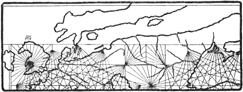
Northern portion of Carignano’s chart (a few years later than 1300)
Sanudo’s work and Pietro Vesconte’s charts, circa 1320
Between the years 1318 and 1321 the Venetian Marino Sanudo wrote a work, “Liber secretorum fidelium crucis” (the Book of Secrets for Believers in the Cross), to rouse enthusiasm for a new crusade, and himself presented a copy of it with a dedication to the Pope at Avignon, which is probably one of the two now preserved at the Vatican. The work is accompanied by several charts which must have been drawn by the well-known cartographer Pietro Vesconte in 1320, since an atlas bearing his name has been found in the Vatican with charts that completely correspond.[216] Among them is a circular map of the world of the wheel type, but on which the forms of the coasts from the compass-charts are introduced. Scandinavia is there represented as a peninsula with a mountain chain (Kjölen ?) along the middle (see map, p. 223), and the names “Gotilandia,” “Dacia,” “Suetia,” “Noruega” may be read. On the continent is written “Guenden [Kvænland, or else == “Suenden” == Sweden ?] vel Gotia”; and on the coast to the north of the peninsula is “Liuonia” and to the south of it “Frixia” [Friesland]. As Kretschmer has shown, Scandinavia was originally drawn (in both atlases) as an island, but was afterwards connected with the continent by a narrow isthmus. This representation of Scandinavia as a peninsula resembles that on many of the wheel-maps mentioned above (see pp. 185, ff.). It also bears a strong resemblance to the view of Saxo (beginning of the thirteenth century), who says:[217]
“Moreover the upper arm of the ocean [i.e., the southern arm, the Baltic, as the south is supposed to be at the top of the map], which cuts through and past Dania, washes the south coast of Gothia [Götaland, i.e., Sweden] with a bay of fair size; but the lower [northern] branch, which goes past the north coast of Gothia and Noruagia, turns towards the east with a considerable widening, and is bounded by a curved coast. This end of the sea was called by our ancient primæval inhabitants Gandvicus. Between this bay and the southern sea lies a little piece of continent, which looks out upon the seas washing it on both sides. If nature had not set this space as a limit to the two almost united streams, the arms of the sea would have met one another, and made Suetia and Noruagia into an island.”
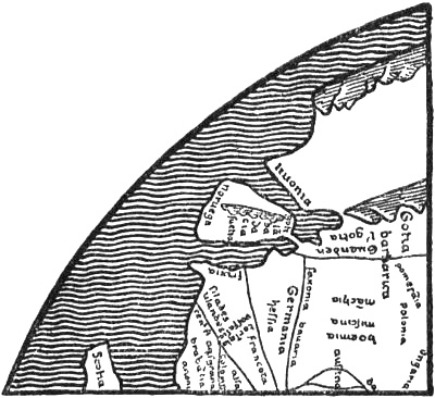
Northern Europe in Vesconte’s mappamundi (1320) in the Vatican (Kretschmer, 1891)
It seems not improbable that the delineation on Vesconte’s map may have a connection with this description; it has also very nearly the same forms of names. The regions far in the north and east on his map are pure fancy, and the “rifei montes” are still found there.
Eight other MSS. (in various libraries) of Sanudo’s work are known, accompanied by maps, and six of them have the circular mappamundi; but the reproductions differ considerably one from another, especially in the representation of the northern coast of Europe.[218] The mappamundi in the MS. in Queen Christina’s collection in the Vatican (Codex Reginensis, 548), and the exactly similar map in the MS. at Oxford, have a remarkably good delineation of the Scandinavian Peninsula (see map, p. 224), with the names “Suetia” [Svealand], “Gotia” [Götaland], and “Scania” on the east, “Noruegia” on the west, “Finlandia” and “Alandia” [Åland, or perhaps Hallandia ?] in the extreme north-east. On the continent is written “Kareli infideles,” “Estonia,” “Liuonia,” etc. In the Baltic are two islands, “Gotlandia” in the middle, and “Ossilia” [Ösel] farthest in. The shape of Jutland [with the names “Dacia” and “Jutia”], the direction of the coast of northern Europe and the Baltic, with Scandinavia parallel to it, remind one a good deal of Edrisi’s map, of the Cottoniana and also of Carignano’s map. Evidently there is here new information which Vesconte did not possess when he drew the map previously mentioned; the correct placing of the names in Sweden and Norway is especially striking. These names, as also “Jutia,” occur in Saxo in approximately the same forms (cf. also Historia Norwegiæ). Marino Sanudo, according to his own statement, had himself sailed from Venice to Flanders, and had also travelled in Holstein and Slavonia. He was thus able to collect geographical information, and, as suggested by Björnbo [1909, pp. 211, f.], may have received communications from North German priests whose picture of the North had been formed by the study of Adam of Bremen and Saxo; but there does not appear to me to be any necessity for such a hypothesis, he may just as well have received direct information from people who knew the localities, while doubtless the names are to a great extent literary. If we suppose that it was Pietro Vesconte who drew all the maps, he may have derived his information about the North through Sanudo himself; but in that case it would be strange that he did not use it for his first map. We must therefore suppose that it was after this that their real collaboration began.
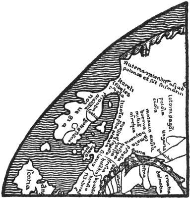
Northern Europe in the mappamundi in the MS. of Sanudo’s work at Oxford (Björnbo, 1910, p. 123)
But here we come upon another difficulty, and this is the third entirely different form of the delineation of the North that is found in the corresponding mappamundi in the MS. of Sanudo at Paris. There the Scandinavian Peninsula is divided in an unaccountable way into several islands, the largest of which bears the name “scania de regno dacie” or “scãdinaua.” To the north of it is a long island, “gotlandia,” which has been read by some “yrlandia” or “yslandia,” and made into Iceland [as in Thoroddsen, i., 1897, p. 84]. “Noruegia” is written outside the border of the map to the north of Jutland [called “dacia”], and the name “prouincia noruicie” is placed on the west coast of Jutland, which has been given a fantastic extension towards the north with many bays. An island in the ocean to the north of Russia [“rutenia”] is marked “kareli infideles.” The whole of this representation is in complete disagreement with the other Sanudo maps, and it is difficult to understand that Vesconte can have also drawn this one, although in other respects it may bear much resemblance to the rest from his hand. One might be inclined to think that some other man had tinkered at this part of the map, introducing ideas which he entirely misunderstood.
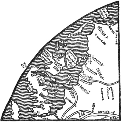
Northern Europe in the mappamundi in the Paris MS. of Sanudo’s work (Björnbo, 1910, p. 123)
A remarkable thing about it is that it is, perhaps, the first that has a legend about the North. For on the large island in the Baltic (?) we read: “In hoc mari est maxima copia aletiorum” [in this sea is the greatest abundance of herrings ?]. In the opinion of Björnbo this may allude to the herring fishery in the Sound.[219]
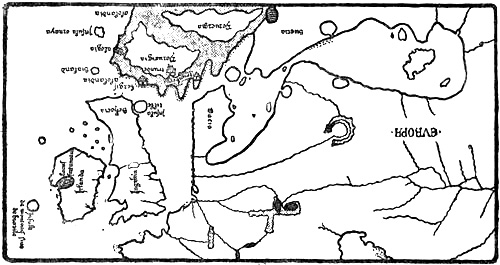
The North on Dalorto’s map of 1325. The network of compass-lines is omitted for the sake of clearness. Only a few of the names are given
Dalorto’s map, 1325
The type which is first known from Angellino Dalorto’s map of 1325 (or 1330 ?), and from that of 1339 signed Angellino Dulcert, which is undoubtedly by the same man, was of fundamental importance to the representation of the North on the Catalan compass-charts. It has been thought that he belonged to a well-known Genoese family named Dalorto, and that the first map was drawn in Italy, while the latter was certainly drawn in Majorca, either by a copyist who corrupted the name of Dalorto to Dulcert, or by himself, who in that case must be supposed to have given his name a more Catalan sound on settling in Majorca. But in any case these maps had Italian models; this appears clearly in the form of the names [cf. Kretschmer, 1909, pp. 118, f.].
The two maps are much alike. The oldest, of 1325 (1330 ?),[220] gives a more complete representation of the North and of the Baltic than any earlier map known (see illustration). In its names it shows a connection both with Carignano’s map and with Marino Sanudo, but new names and fresh information have been added, the delineation of Great Britain and Ireland is more correct, and there is also a more reasonable representation of Scandinavia and of the extent of the Baltic than on Carignano’s map. Amongst new names in the North may be mentioned “trunde” [Trondhjem, cf. “Throndemia” in the Historia Norwegiæ], and “alogia” for a town on the west side of Norway; this is evidently Halogia [Hálogaland], a form of the name which was used, for instance, in the Historia Norwegiæ and by Saxo. Another name in the far north, and again at the south-western extremity of Norway, is “alolandia” (see illustration, p. 226). One might suppose that the form of the name and its assignment to these two places are due to a confusion of the name Hálogaland with Hallandia (in Saxo) and “alandia” on the Sanudo-Vesconte map (see p. 224).
It will be seen that Norway, which is represented as a pronouncedly mountainous country,[221] has on this map been given a great increase of breadth, so that its west coast is brought to the same longitude as the west coast of Great Britain. In the legends attached to Norway we read that from its deserts are brought “birds called gilfalcos” (hunting falcons), and in the extreme north is the inscription:
“Here the people live by hunting the beasts of the forest, and also on fish, on account of the price of corn which is very dear. Here are white bears and many animals.”
The substance of this may be derived in the main from the Geographia Universalis (cf. pp. 189, f.; see also p. 177). Islands in the ocean to the west of Norway are: farthest north, “Insula ornaya” [the Orkneys]; farther south, “sialand” [Shetland, “Insula scetiland” on the map of 1339, and “silland” or “stillanda” on later maps]. The resemblance to “shâsland,” the name of an island in Edrisi (cf. above, p. 207), is great, but it cannot be supposed that we have here a corruption of Iceland. At the north-eastern corner of Scotland is the round island, “Insula tille” (cf. p. 219).
The Isle of Brazil
In the ocean to the west of Ireland we find for the first time on this map an island called “Insula de montonis siue de brazile.” This island is met with again on later compass-charts under the name of “brazil” as late as the sixteenth and seventeenth centuries.[222] It is evidently the Irish fortunate isle “Hy Breasail,” afterwards called “O’Brazil,” that has found its way on to this map, or probably on to the unknown older sources from which it is drawn. On this and the oldest of the later maps the island has a strikingly round form, often divided by a channel.
The Irish myth of Hy Breasail, or Bresail,[223] the island out in the Atlantic (cf. vol. i. p. 357), is evidently very ancient; the island is one of the many happy lands like “Tír Tairngiri” [the promised land]. In the opinion of Moltke Moe and Alf Torp the name may come from the Irish “bress” [good fortune, prosperity], and would thus be absolutely the same as the Insulæ Fortunatæ. The Italians may easily have become acquainted with this myth through the Irish monasteries in North Italy, unless indeed they had it through their sailors, and in this way the island came upon the map. The form “brazil” may have arisen through the cartographer connecting the name with the valuable brazil-wood, used for dyeing. The channel dividing the island of Brazil on the maps may be the river which in the legend of Brandan ran through the island called “Terra Repromissionis,” and which Brandan (in the Navigatio) was not able to cross. It is probably the river of death (Styx), and possibly the same that became the river at Hop in the Icelandic saga of Wineland (see vol. i. p. 359). We thus find here again a possible connection, and this strengthens the probability that Brazil was the Promised Land of the Irish, which on the other hand helped to form Wineland.
On later compass-charts several isles of Brazil came into existence. As early as in the Medici Atlas (1351) an “Insula de brazi” appears farther south in the ocean, to the west of Spain, and on the Pizigano map (1367) and the Soleri map (1385) there is to the west of Brittany yet a third “brazir,” afterwards commonly called “de manj,” or “maidas,” etc.[224] The name “Insula de montonis” is difficult to understand. If we may believe it to be an error for “moltonis” (or perhaps “moutonis,” a latinisation of the French “mouton” ?), it might mean the sheep island of the Navigatio Brandani, which was originally Dicuil’s Faroes (cf. vol. i. p. 362). Thus this name also carries us to Ireland.[225]
At the same time another Irish mythical conception has found its way on to the map of 1325, and faithfully attends the isle of “Brazil” on its progress through all the compass-charts of later times; this is the fortunate lake, “lacus fortunatus,” with its islands, “insulle sc̄i lacaris” [Lough Carra or Lough Corrib ?], which were so numerous that there was said later to be one for every day of the year. On Perrinus Vesconte’s map of 1327 the same lake with its many islands is found, and as far as I can read the greatly reduced reproduction in Nordenskiöld’s Periplus (Pl. VII.) the words are: “gulfo de issolle CCCLVIII.[226] beate et fortunate” (the gulf of the 358 blessed and happy islands), as also found on some later maps.[227] I have not had an opportunity of examining the map of the British Isles in the same draughtsman’s atlas of 1321, to see whether this happy lake and the isle of Brazil are given there; the gulf with the 358 islands is stated to be on Vesconte-Sanudo maps [cf. Harrisse, 1892, pp. 57, f.], which I have also had no opportunity of consulting.
Dulcert’s (Dalorto’s) map of 1339
Angellino Dulcert’s (Dalorto’s) map of 1339[228] differs somewhat from the map of 1325 (1330 ?) in its delineation of the North, in that Norway is given a narrower and more rectangular form, with only those four headlands on the south side which are largest on the map of 1325, while the country with the smaller headlands to the west of these is cut away, whereby the narrower shape is brought about.[229]
Dalorto’s maps of 1325 and 1339 furnish the prototype for the representation of the North in later compass-charts; and this persists without important alteration until well into the fifteenth century. But while later Italian charts (cf. Pizigano’s of 1367) more closely resemble the Italian Dalorto map of 1325, the Majorca map of 1339 represents the type of the later Catalan charts. In the one preserved at Modena, and dating from about 1350,[230] the Catalan compass-chart is combined with the representation of the world of the wheel-maps. We find the picture of the North to be the same in all its main outlines; but here a new feature is added, in that Iceland appears as a group of eight islands in the far north-west, out on the margin of the map, with the note: “questas illes son appellades islandes” (these islands are called Icelands). The southernmost island is called “islanda,” the others have incomprehensible names (“donbert,” “tranes,” “tales,” “brons,” “bres,” “mmau...,” “bilanj” [?]); but the name of Greenland is not found. In the ocean to the north of Norway there is “Mare putritum congelatum” [the putrid, frozen sea]. This is evidently the idea of the stinking Liver Sea (as in Arab myths, cf. p. 51), combined with that of the frozen sea. On the approximately contemporary Catalan compass-chart (see the reproduction, pp. 232-233), preserved in the National Library at Florence (called No. 16), we find the same group of islands called “Island,” with a long inscription (see p. 232; cf. also Björnbo and Petersen, 1908, p. 16), which is partly illegible, but wherein it is stated that “the islands are very large,” that “the people are handsome, tall and fair, the country is very cold,” etc. The name of Greenland does not occur on this chart either.[231]
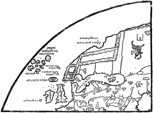
North-western Europe on the wheel-shaped compass-chart at Modena (circa 1350). The network of compass-lines, names and legends omitted. Mountains indicated by shading
Larger Image
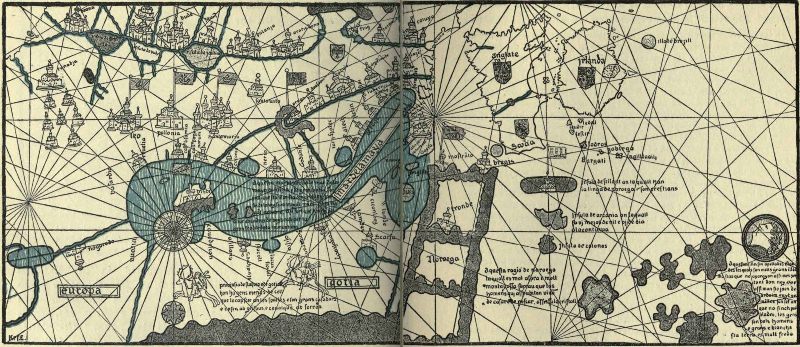
North-western Europe on the anonymous Catalan mappamundi of the middle of the fourteenth century, in the National Library at Florence. Reproduced mainly from a tracing of the original made by Dr. A. A. Björnbo. The text of the names and legends has been somewhat enlarged to render it legible in the reduced reproduction. In the legend on the Baltic the erroneous “gronlandia” is given, while the original has “gotlandia” (according to O. Vangensten)
Viladeste’s chart of 1413
The same type of Catalan charts includes Charles V.’s well-known mappamundi, or “Catalan Atlas,” of 1375, as well as Mecia de Viladeste’s chart of 1413,[232] and many others.[233]
The Medici Atlas, 1351
We find a different representation of the North, especially of the Scandinavian Peninsula, in the anonymous atlas of 1351, preserved at Florence and commonly called the “Medicean Marine Atlas,”[234] which is an Italian, probably a Genoese, work. The North is here represented on a map of the world and on a map of Europe (reproduced pp. 236, 260). The representation to a great extent resembles the Dalorto type. Its division of western Scandinavia into three great promontories no doubt recalls the Carignano map to such an extent that one may suppose it to have been influenced by some Italian source of that map; but in the names it shows more resemblance to the Dalorto maps: the delineation of the Baltic and of the peninsula corresponding to Skåne is practically the same, it perhaps resembles in particular the Modena map and the anonymous map at Florence (cf. pp. 232, 233). Jutland, on the other hand, has been greatly prolonged and given a different shape. The three great tongues of land in Norway, with a smaller one on the east near Denmark, may correspond to the four headlands on the south coast of Norway on the Dalorto maps (cf. especially that of 1339). Through these being considerably increased in size, and the bays between them being enlarged, the west coast of Norway has been moved even farther to the west than on the map of 1325, and has been given a somewhat more westerly longitude than Ireland. On the map of Europe “C. trobs” [“capitolum tronberg” ? i.e., Tönsberg] is written on the first bay [like “trunberg” on the Dalorto map], “c. bergis” [“capitolum bergis,” i.e., the see of Bergen] and “c. trons” (?) [the see of Trondhjem] on each of the two other bays. Finally, “alogia,” which on the Dalorto map is marked as a town on the northern west coast of Norway, to the north of Nidroxia [Nidaros], has followed the west coast and is placed on the westernmost tongue of land. How the whole of this delineation came about is difficult to say. One might be tempted to think that it was through a misunderstanding of a description of Norway, like that we find in the Historia Norwegiæ, where the country is described as divided into four parts, the first being the land on the eastern bay near Denmark, the second “Gulacia” [Gulathing], the third “Throndemia,” the fourth “Halogia.”[235] The map of the world in the Medici atlas is drawn in the same way as the compass-charts. It has no names of towns in Scandinavia, and the westernmost tongue of land is without a name (see the reproduction). On the other hand, the name “alolanda” occurs inland in eastern Norway, and is there obviously a corruption of “Hallandia” (cf. p. 227). This mappamundi is interesting from the fact that it makes the land-masses of the continent extend without a limit on the north, whereas Africa is terminated by a peninsula on the south.