Chapter XIII · (continued 2)
Arthur G. Chater translation
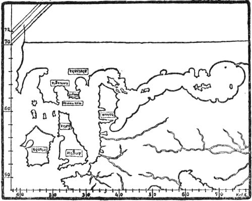
The north-western portion of the mappamundi in the Medicean Marine Atlas (1351). The degrees are here inserted after the maps of Ptolemy
Pizigano’s map, 1367
The map of the Venetian Francesco Pizigano, of 1367, resembles Dalorto’s of 1325 in its delineation of the North; the south side of Norway has somewhat the same rounded form with seven headlands, and “Alogia” is a town on the west coast.

From the Bayeux tapestry, eleventh century
VIEWS OF THE NORTH AMONG THE NORTHERN PEOPLES
Scandinavian view of Greenland as mainland
It has been already pointed out that, while the oldest northern authority, Adam of Bremen, regarded the countries of the North, outside Scandinavia, as islands in the ocean surrounding the earth’s disc (in agreement with the learned view and with the wheel-maps), the Scandinavians, unfettered by learned ideas, assumed that Greenland was connected with the continent, for the reason, amongst others, that, as the author of the “King’s Mirror” expresses it, continental animals such as the hare, wolf and reindeer could not otherwise have got there. But, as we have seen, this land communication could only be supposed to exist on the far side of Gandvik (the White Sea) and the Bjarmeland (Northern Russia) that they knew, and to go round the north of the sea that lay to the north of Norway. Thus the sea came to be called Hafsbotn (i.e., the bay or gulf of the ocean). We find the clearest expression of this view in the Icelandic geography already referred to, which may in part be attributed to Abbot Nikulás Bergsson of Thverá[236] (cf. vol. i. p. 313; vol. ii. pp. 1, 172), and where we read:
“Nearest Denmark is lesser Sweden [so called to distinguish it from ‘Sviþjóð it Mikla,’ Russia], there is Öland, then Gotland, then Helsingeland, then Vermeland, then two Kvænlands, and they are north of Bjarmeland. From Bjarmeland uninhabited country extends northward as far as Greenland. South of Greenland is Helluland,” etc. [cf. the continuation, above, p. 1]. In a variant of this geography in an older MS. we read: “North of Saxland is Denmark. Through Denmark the sea goes into ‘Austrveg’ [the countries on the Baltic]. Sweden lies east of Denmark, but Norway on the north. To the north of Norway is Finmark. From thence the land turns towards the north-east, and then to the east before one comes to Bjarmeland. This is tributary to the Garda-king [the king of Gardarike]. From Bjarmeland the land stretches to the uninhabited parts of the north, until Greenland begins. To the south of Greenland lies Helluland,” etc.
We have yet a third, later and more detailed variant in the so-called “Gripla,” given in vol. i. p. 288.
The belief in this land connection with Greenland may have originated in, or at any rate have been considerably strengthened by, the discovery of countries such as Novaya Zemlya, Svalbard (Spitzbergen ?), and the northern uninhabited parts of the east coast of Greenland[237] (cf. above, pp. 165, ff.). In addition to this, those sailing the Polar Sea came across pack-ice wherever they went in a northerly direction, closing in the sea and making it like a gulf, and it must therefore have been natural to believe in a continuous coast which connected the countries behind the ice, and which held this fast. The belief in a land connection seems to have been so ingrained that it can scarcely have rested on nothing but theoretical speculations, but must rather have been supported by tangible proofs of this kind.
Saxo on the far North
It was to be expected that the countries on the north of Hafsbotn should become fairylands in popular belief, Jotunheimr and Risaland, inhabited by giants. Even Saxo (beginning of the thirteenth century) says that to the north of Norway
“lies a land, the name and position of which are unknown, without human civilisation, but rich in people of monstrous strangeness. It is separated from Norway, which lies opposite, by a mighty arm of the sea. As the navigation there is very unsafe, few of those who have ventured thither have had a fortunate return.”
As it can hardly be the Christian settlements in Greenland that Saxo refers to as a land without human civilisation, we must doubtless suppose that his land in the north is a confusion of the eastern uninhabited tracts of Greenland with Jotunheimr, as in Icelandic ideas. For Adam of Bremen already had giants (Cyclopes) on an island in the north, and we have seen that there were similar conceptions in the Historia Norwegiæ (cf. p. 167).
The tale of Halli Geit
A mediæval Icelandic tale [inserted in Björn Jónsson’s Greenland Annals] says of Halli Geit that
“he alone succeeded in coming by land on foot over mountains and glaciers and all the wastes, and past all the gulfs of the sea to Gandvik and then to Norway. He led with him a goat, and lived on its milk; he often found valleys and narrow openings between the glaciers, so that the goat could feed either on grass or in the woods.”
From the Bayeux tapestry, eleventh century
Land at the North Pole
Ideas of this kind led to the view held by some that there was land as far as the North Pole, which appears in an Icelandic tract, included in the “Rymbegla” [1780, p. 466]. Of a bad Latin verse, there reproduced, it is said:
“Some will understand this to mean that he [i.e., the poet] says that land lies under ‘leidarstjarna’ [the pole star], and that the shores there prevent the ring of the ocean from joining [i.e., around the disc of the earth]; with this certain ancient legends agree, which show that one can go, or that men have gone, on foot from Greenland to Norway.”
The Outer Ocean
But the mediæval learned idea of the Outer Ocean surrounding the whole disc of earth also asserts itself in the North, and appears in Snorre’s Heimskringla and in the “King’s Mirror,” amongst other works. This ocean went outside Greenland, which was connected with Europe, and made the former into a peninsula. In the work already referred to, “Gripla” (only known in a late MS. in Björn Jónsson of Skardsá, first half of the seventeenth century), we read, in continuation of the passage already quoted (p. 35): “Between Wineland and Greenland is Ginnungagap, it proceeds from the sea that is called ‘Mare oceanum,’ which surrounds the whole world.” Since Wineland [i.e., the Insulæ Fortunatæ], as already stated (pp. 1, ff.), was by some, evidently through a misunderstanding, made continuous with Africa,[238] it is clear that the Outer Ocean must be supposed to go completely round both Greenland and Wineland (cf. the illustration, p. 2). Thus it was also natural to suppose that there was an opening somewhere between these two countries, through which the Outer Ocean was connected with the inner, known ocean between Norway, Greenland, etc.[239]
Ginnungagap
At least as old as the Norsemen’s conceptions of countries beyond the ocean in the North was probably the idea of the great abyss, Ginnungagap, which there forms the boundary of the ocean and of the world, and which must be derived from the Tartarus and Chaos of the Greeks (cf. p. 150). When the Polar Sea (Hafsbotn) was closed by the land connection between Bjarmeland and Greenland, it was natural that those who tried to form a consistent view of the world could no longer find a place for the abyss in that direction; and G. Storm [1890] is certainly right in thinking that it was for this reason that Ginnungagap was located in the passage between Greenland and Wineland; since, no doubt, the idea was that this “gap” in some way or other was connected with the void Outer Ocean. But this view is first found in the very late copy (seventeenth century) of “Gripla,” and of the somewhat older map of Gudbrand Torlaksson [Torlacius] of 1606 [Torfæus, 1706; Pl. I., p. 21], where “Ginnunga Gap” is marked as the name of the strait between Greenland and America. What Ginnungagap really was seems never to have been quite clear, different people having no doubt had different ideas about it; but when, as here, it is used as the name of a strait through which the Outer Ocean enters, it cannot any longer be an abyss; at the most it may have been a maelstrom or whirlpool, which, indeed, is suggested by the whirlpool on Jón Gudmundsson’s map (cf. p. 34). But even this interpretation of the name became effaced, and in another MS. of the seventeenth century (see p. 35) it is simply used as a name for the great ocean to the west of Spain (that is, the Atlantic).
From an Icelandic MS. of 1363
On the other hand we have seen (pp. 150, ff.) that ideas of whirlpools in the northern seas appear to have been widely spread in the Middle Ages. There is a possibility, as already hinted (vol. i. p. 303), that when in Ivar Bárdsson’s description of the northern west coast of Greenland “the many whirlpools that there lie all over the sea” are spoken of, it was thought that here was the boundary of the ocean and of the world, and that it was formed by the many whirlpools, or abysses in the sea. In that case these cannot be regarded merely as maelstroms like the Moskenström, but more like the true Ginnungagap. But this is extremely uncertain; it may again have been one of those embellishments which were often used in speaking of the most distant regions.
Saxo
Saxo Grammaticus (first part of the thirteenth century) in the preface to his Danish history gives geographical information about Scandinavia and Iceland, to which we have already referred several times. He does not mention Greenland. He says himself that he has made use of Icelandic literature to a large extent; but he has also mingled with it a good deal of mythical material from elsewhere.
The King’s Mirror, circa 1240 ?
Beyond comparison the most important geographical writer of the mediæval North, and at the same time one of the first in the whole of mediæval Europe, was the unknown author who wrote the “King’s Mirror,”[240] probably about the middle of the thirteenth century.[241] If one turns from contemporary or earlier European geographical literature, with all its superstition and obscurity, to this masterly work, the difference is very striking. Even at the first appearance of the Scandinavians in literature, in Ottar’s straightforward and natural narrative of his voyage to King Alfred, the numerous trustworthy statements about previously unknown regions are a prominent feature, and give proof of a sober faculty of observation, altogether different from what one usually meets with in mediæval literature. This is the case to an even greater degree in the “King’s Mirror,” and the difference between what is there stated about the North and what we find less than two hundred years earlier in Adam of Bremen is obvious. Apart from the fact that the whole method of presentation is inspired by superior intelligence, it shows an insight and a faculty of observation which are uncommon, especially at that period; and in many points this remarkable man was evidently centuries before his time. Although well acquainted with much of the earlier mediæval literature, he has liberated himself to a surprising extent from its fabulous conceptions. We hear nothing of the many fabulous peoples, who were still common amongst much later authors, nor about whirlpools, nor the curdled and dark sea, but instead we have fresh and copious information about the northern regions, and it comes with a clearness like that which already struck us in Ottar. We have a remarkably good description of the sea-ice, its drift, etc. (cf. vol. i. pp. 279, f.); we have also a description of the animal world of the northern seas to which there is no parallel in the earlier literature of the world (cf. pp. 155, ff.). No less than twenty-one different whales are referred to fully. If we make allowance for three of them being probably sharks, and for two being perhaps alternative names for the same whale, the total corresponds to the number of species that are known in northern waters. Six seals are described, which corresponds to the number of species living on the coasts of Norway and Greenland. Besides these the walrus [“rostung”] is very well described. But even the author of the “King’s Mirror” could not altogether avoid the supernatural in treating of the sea. He describes in the seas of Iceland the enormous monster “hafgufa,” which seems more like a piece of land than a fish, and he does not think there are more than two of them in the sea. This is the same that the Norwegian fishermen now call the krake, and certainly also the same that appears in ancient oriental myths, and that is met with again in the Brandan legend as the great whale that they take for an island and land on (cf. p. 234). In the Greenland seas the “King’s Mirror” has two kinds of trolls, “hafstrambr” [a kind of merman], with a body that was like a glacier to look at, and “margygr” [a mermaid], both of which are fully described. There is also mention in the Greenland seas of the strange and dangerous “sea-fences,” which are often spoken of in the sagas [and about which there is a lay, the “hafgerðinga-drápa”]. The author does not quite know what to make of this marvel, for “it looks as if all the storms and waves that there are in that sea gather themselves together in three places, and become three waves. They fence in the whole sea, so that men cannot find a way out, and they are higher than great mountains and like steep summits,” etc. It is probable that the belief in these sea-fences is derived from something that really took place, perhaps most likely earthquake-waves, or submarine earthquakes, which may sometimes have occurred near volcanic Iceland. But it is curious that in the “King’s Mirror” these waves are connected with Greenland. They might also be supposed to be connected with the waves that are formed when icebergs capsize.
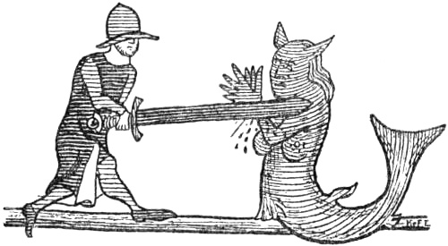
Marginal drawing in the Flateyjarbók (1387-1394)
The principal countries described are Ireland, Iceland and Greenland; but it is characteristic of the author that the farther north he goes, away from regions commonly known, the freer his account becomes from all kinds of fabulous additions. In Ireland he is still held fast by the superstition of the period, and especially by the priests’ fables about themselves and their holy men, and by the English author Giraldus Cambrensis.[242] In Iceland, as a rule, he is free of this troublesome ballast, and gives valuable information about the glaciers of Iceland, glacier-falls, boiling springs, etc. In his opinion the cold climate of Iceland is due to the vicinity of Greenland, which sends out great cold owing to its being above all other lands covered with ice; for this reason Iceland has so much ice on its mountains. Although he thinks it possible that its volcanoes are due to the fires of Hell, and that it is thus the actual place of torment, and that Hell is therefore not in Sicily, as his holiness Pope Gregory had supposed, he nevertheless has another and more reasonable explanation of the origin of earthquakes and volcanoes. They may be due to hollow passages and cavities in the foundations of the land, which by the force either of the wind or of the roaring sea may become so full of wind that they cannot stand the pressure, and thus violent earthquakes may arise. From the violent conflict which the air produces underground, the great fire may be kindled which breaks out in different parts of the country. It must not be thought certain that this is exactly how it takes place, but one ought rather to lay such things together to form the explanation that seems more conceivable, for
Fire derived from force (labour)
“we see that from force [‘afli’] all fire comes. When hard stone and hard iron are brought together with a blow, fire comes from the iron and from the force with which they are struck together. You may also rub pieces of wood together until fire comes from the labour that they have. It is also constantly happening that two winds arise from different quarters, one against the other, and if they meet in the air there is a hard shock, and this shock gives off a great fire, which spreads far in the air,” etc.
This idea of a connection between labour (friction) and force (motion), and this explanation of the possible origin of volcanoes are surprising in the thirteenth century, and seem to bring the author centuries in advance of his time; we here have germs of the theory of the conservation of energy.
The inland ice of Greenland
His statements about Greenland are remarkable for their sober trustworthiness. He gives the first description of its inland ice:
“But since you asked whether the land is thawed or not, or whether it is covered with ice like the sea, you must know that there are small portions of the land which are thawed, but all the rest is covered with ice, and the people do not know whether the country is large or small, since all the mountains and valleys are covered with ice, so that no one can find his way in. But in reality it must be that there is a way, either in those valleys that lie between the mountains, or along the shores, so that animals can find a way, for otherwise animals cannot come there from other countries, unless they find a way through the ice and find the land thawed. But men have often tried to go up the country, upon the highest mountains in various places, to look around them, to see whether they could find any part that was thawed and habitable, but they have not found any such, except where people are now living, and that is but little along the shore itself.”
Norwegian MS. of the Gulathings law. Fourteenth century
This, as we see, is an extremely happy description of the mighty ice-sheet. He also describes the climate of the country, both the fine weather that often occurs in summer, and its usually inclement character, which causes so small a proportion of the country to be habitable.
The glaciers of Greenland a pole of maximum cold
“The land is cold, and the glacier [i.e., the great ice or inland ice] has this nature, that he sends out cold gusts which drive away the showers from his face, and he usually keeps his head bare. But often his near neighbours have to suffer for it, in that all other lands which lie in his neighbourhood get much bad weather from him, and all the cold blasts that he throws off fall upon them.”
Though in simple and everyday words, this really expresses the idea that Greenland and the neighbouring regions are disproportionately cold, and that, in part at any rate, this is due to the glaciers of Greenland, which have a refrigerating effect (as an anticyclonic pole of maximum cold). This is to a certain degree correct. In crossing Greenland in 1888 we found that a pole of cold [anticyclone] lies over the inland ice, which gives off cold air. Scientific greatness does not always depend on erudition or acute learned combinations; it is just as often the result of a sound common-sense.
The allusion in the “King’s Mirror” to the Norse inhabitants of Greenland and their life has already been quoted in part (vol. i. p. 277); curiously enough the Skrælings are not mentioned. The author gives a graphic description of the aurora borealis, and attempts to explain its cause. As already noted (p. 155), it is curious that he should speak of it as something peculiar to Greenland, when he must of course have known it well enough in Norway.
The cosmography of the “King’s Mirror” is based on older mediæval writers, especially Isidore. The spherical form of the earth and the course of the sun are mentioned, as is Macrobius’s doctrine of zones. In the frigid zones the cold has attracted to itself such power that the waters throw off their nature and are changed to ice, and all the land and sea is covered with ice. They are usually uninhabitable, but nevertheless the author considers that Greenland lies in the north frigid zone. He thinks that “it is mainland, and connected with other mainland,” as already mentioned, because it has a number of terrestrial animals that are not often found on islands. It
“lies on the extreme side of the world on the north, and he does not think there is land outside ‘Heimskringla’ [the circle of the world, ‘orbis terrarum’] beyond Greenland, only the great ocean which runs round the world; and it is said by men who are wise that the strait through which the empty ocean flows comes in by Greenland, and into the gap between the lands (‘landa-klofi’), and thereafter with fjords and gulfs it divides all countries, where it runs into Heimskringla.”
This is, as we see, the same idea as already (p. 240) referred to, that the Outer Ocean runs in through a sound between Greenland and another continent to the south, evidently Wineland, which is thus here again regarded as part of Africa (cf. p. 1).
It is moreover striking that neither Wineland, Markland, nor Helluland is mentioned in the “King’s Mirror,” and Bjarmeland, Svalbard, etc., are also omitted. Thus it does not give any complete description of the northern lands, but it must be remembered that what we know of the work is only a fragment, and perhaps it was never completed.
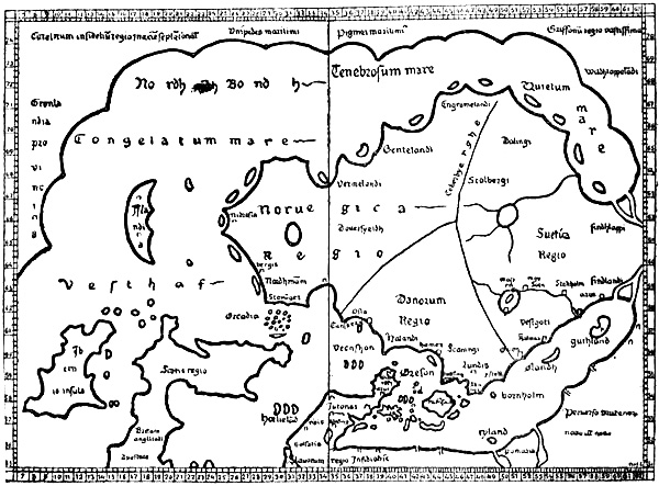
The Nancy map. A copy, of 1427, of Claudius Clavus’s first map of the North. The lines of latitude and longitude are omitted for the sake of clearness
CLAUDIUS CLAVUS
Claudius Claussön Swart, born 1388 Clavus’s maps
The credit of having introduced the name of Greenland, with the ancient Norsemen’s geographical ideas about the extreme North, into cartography belongs, so far as is known, to the Dane Claudius Claussön Swart, usually called in Latin Claudius Clavus (sometimes also Nicolaus Niger). He was born in Funen, travelled about Europe, and, as shown by Storm [1891, pp. 17, f.], was probably the “Nicolaus Gothus” who is mentioned at Rome in January 1424, and who is reported to have there given out that he had seen a copy of Livy in the monastery of Sorö, near Roskilde (which was probably a romance on his part). We are told that he was a man of acute intelligence, but a rover and unsteady. His subsequent history is unknown. As a supplement to Ptolemy’s Geography, which just at that time (1409) was becoming known in Western Europe in a Latin translation, he made, probably in Italy, two maps of the North, with accompanying descriptions. The maps must have been drawn either by himself or with his help. They are the first maps known in Western Europe which are furnished, after the model of Ptolemy (or Marinus), with lines of latitude and longitude,[243] and they thus mark the beginning of a more scientific cartography and geography in Western Europe.[244]
His first map (the Nancy map) must have been drawn between the years 1413 and 1427, probably between 1424 and 1427; but it can never have been widely known, as it has exercised no noticeable influence on the cartography of the succeeding period. The French cardinal Filastre (ob. 1428), who was staying in Rome in 1427, became acquainted with it there, and made a reduced copy of it, which, together with a copy of the accompanying text, he had bound up with his copy of the Latin translation of Ptolemy’s Geography with maps. This work was not rediscovered at Nancy until 1835, when it was published; the map is therefore usually called the Nancy map. Clavus’s second map, which seems to have been drawn later than that just mentioned, has on the other hand had considerable influence on the cartographical representation of the northern regions through a period of two centuries.
A copy of the later map was first brought to light by Nordenskiöld at Warsaw in 1889 [1889, p. xxx.]; since then several copies have been rescued from oblivion, while the text accompanying the map was accidentally discovered in 1900 by Dr. A. A. Björnbo in a mediæval MS. at Vienna [Björnbo and Petersen, 1904]. The original map is lost; but except as regards details of no great consequence there can now be no doubt as to what it was like.
The reproductions (pp. 248 and 251) will give an idea of the representation of the North on the two maps. As far as Ptolemy’s map extended (cf. vol. i. pp. 118, f.), it will be seen that its coast-lines and islands are almost slavishly adhered to on both maps. To this the Nancy map adds a Scandinavia, with Iceland, the east coast of Greenland, and a northern land connection between the latter and Russia. On the later map Scandinavia has been given a somewhat altered form, and Greenland has a west coast. The Nancy map has few names, many more being mentioned in the text, especially in Denmark. Even as regards Denmark they are evidently to a great extent taken from an older itinerary like that of Bruges [“Itinéraire Brugeois,” cf. Storm, 1891, p. 19]. Some of the names on the map, like “bergis,” “nidrosia,” etc., may be taken from older compass-charts; both texts have the northern form “Bergen.” Headlands, bays and islands (on the coasts of Norway, Iceland and Greenland), for which he had no names (and which moreover are due to the free imagination of the draughtsman), have been designated in the Nancy text by Latin numerals (“Primum,” “Secundum,” etc.), or are simply named after each other (in Iceland), a sure sign that Clavus neither knew nor had heard anything about these coasts.
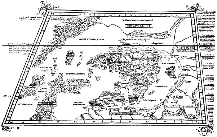
Copy, of about 1467, of Claudius Clavus’s later map. The copy was executed by Nicolaus Germanus. Owing to the map being transferred to the latter’s trapezoidal projection, with converging meridians, Greenland, for instance, has been given a very oblique appearance
Mystification in Clavus’s geographical names
On his later map Clavus has made up for the want of names in an astonishing way. On some of the coasts he has continued to use Latin numerals for bays, etc., but side by side with this on the shores of the Baltic and in Sweden he has used Danish numerals, such as, “Förste aa fluuii ostia” (First river, river-mouth), “Anden aa” (Second river) ..., etc. The southerners, who did not understand Danish, of course regarded these as names, and subjected them to all sorts of corruptions. Matters became worse when in Gotland and Norway he used as the names of headlands and rivers the words of a meaningless rigmarole: “Enarene,” “apocane,” “uithu,” “wultu,” “segh,” “sarlecrogh,” etc. (evidently corresponding to children’s rigmaroles like “Anniken, fanniken, fiken, foken,” etc.)[245] In Iceland he used the names of the runic characters for headlands and rivers; but most remarkable of all are his names in Greenland, alternately for headlands and the mouths of rivers(!). If, as shown by Björnbo and Petersen, these are read continuously from the most northern headland on the east coast round the south of the country, the following verse in the dialect of Funen is the result:
“Thær boer eeynh manh secundum [== ij ?][246] eyn Gronelandsz aa, ooc Spieldebedh mundhe hanyd heyde; meer hawer han aff nidefildh, een hanh hawer flesk hinth feyde. Nordh um driuer sandhin naa new new.” (There lives a man (in ?) a Greenland river, and Spieldebedh is his name; he has more vermin (?) than he has fat bacon, etc.)
The verse, as pointed out by Axel Olrik, is evidently an imitation or travesty of the folk-songs, and, as Karl Aubert has shown,[247] its prototype must certainly have been the first verse of the same folk-song that is now known in Sweden by the name of “Kung Speleman”:
“Dher bodde een kjempe vid Helsingborg, Kung Speleman månde han heta, Visst hade han mera boda sölf, Än andra flesket dhet feta. Uren drifver noran, och hafvet sunnan för noran.” (There lived a giant by Helsingborg, King Fiddler was his name. Sure he had greater store of silver Than others of fat bacon, etc.)
This method of fabricating geographical names adopted by Clavus recalls the designation of the notes in the mediæval scale, for which the words of a Latin hymn were used, and it seems likely that this is what he has imitated. But his mystification, with all these strange names which no one in Southern Europe understood, and which in course of time underwent many corruptions, has caused a good deal of trouble; many intelligent men have racked their brains to discover learned etymological interpretations of their origin, until Björnbo’s lucky find of the later text of Clavus solved the riddle.
Different views of Clavus’s maps and their origin
Björnbo and Petersen, who by their valuable work on Claudius Clavus with a reproduction of this text have the credit of throwing light on the relation between his first and second maps, have put forward the view that Clavus must have made his first map (the Nancy map) with its Latin text in Italy; but curiously enough they think he entirely rejected the Italian compass-charts as unsuitable for the representation of the North, and constructed his delineation of the northern regions independently of them, as an addition to Ptolemy’s coast-lines, simply from information he had derived from northern sources. After this we are to suppose that, in order to extend his geographical knowledge, he went back to Denmark; and since the authors place reliance on Clavus’s assertion (in his later text) that he had seen the places himself, they even credit him with having made a voyage of geographical exploration, first to Norway (Trondhjem) and then to Greenland. And then he is supposed to have drawn his later map, and written the text for it (in Latin), in the North.
I have come to an entirely different conclusion. His older map must be based, in my opinion, not only on Ptolemy, but to a great extent on Italian maps. His later map and text, I consider, show beyond doubt that he cannot have been either in Norway or Greenland, and I cannot find a single statement in the Vienna text, or any coast-line in his later map, which shows that he was outside Italy in the period between the two works. Doubtless the delineation of Denmark, especially Sealand, is more detailed in the second map; but the additions do not disclose any more local knowledge than might be attributed to Clavus as a native of Funen before his first map was drawn, even though he had not then ventured to change the form of Ptolemy’s Scandia, which to him, of course, became Sealand. After this first attempt, however, he may have gained courage to launch out further with his knowledge. He may also have discovered a few fresh pieces of information, in the papal archives, for instance. Besides this, he may, of course, have received oral communications from people from the northern countries; but even of this I am unable to find sure signs. In consideration of the imaginative tendencies shown by Clavus in his distribution of names, and to some extent in the coast-lines on his map, which perhaps may also have asserted themselves in his statement that he had seen a complete MS. of Livy in Sorö monastery,[248] we shall scarcely be insulting him if we believe his statements (in two passages of the Vienna text) that he himself had seen Pygmies from a land in the North, and Karelians in Greenland, to be rhetorical phrases, calculated to strengthen the reader’s confidence, and to mean at the outside that he had seen something about these people in older authorities.
After having heard my reasons, Björnbo and Petersen have in all essentials come round to my views. In particular they agree with me that Clavus cannot have been in Greenland, but that the delineation of that country on his later map is based on the Medicean map of the world, which will be mentioned later. I therefore consider it superfluous to combat any further here the reasons given in their work for their former view.
Claudius Clavus’s task must have been to supplement the newly discovered atlas of Ptolemy by what he knew of the North; and to this end his maps were drawn, either by himself or by a professional draughtsman in Italy from his instructions. The text was prepared after each of the maps, as a description of it; and the latitudes and longitudes are taken from the map [cf. Björnbo and Petersen, 1904, p. 130]. With the superstitious respect of the period for older learned authorities in general, and for Ptolemy in particular, he did not venture to alter the latter’s coast-lines or latitudes as far as they extended; even in the Danish islands he has done so with hesitation, thus Sealand in his first sketch [the Nancy map] has still the same form as Scandia in Ptolemy, etc. He then added to the latter’s coast-lines what he knew or could get together from other quarters.
Sources and genesis of the Nancy map
His first map [the Nancy map] may presuppose the following sources, besides Ptolemy’s various maps of Northern Europe; Pietro Vesconte’s mappamundi (circa 1320) in Marino Sanudo’s work,[249] and the anonymous mappamundi, now preserved in the so-called Medicean Marine Atlas, of 1351, at Florence.[250] In addition to these, either the Bruges itinerary itself [Itinéraire Brugeois, cf. Storm, 1891, p. 19], or one of its earlier sources. Possibly he also had, in part at all events, a tract [in Icelandic ?] that is included in the fourth part of the “Rymbegla” [1780]; that he also knew of the Icelandic sailing directions, as assumed by Björnbo and Petersen, I regard as less certain, although not impossible; perhaps it would be safer to suppose that he may have seen some statements from Ivan Bárdsson’s description of Greenland, in an itinerary, for instance. I have not been able to find any certain indication of his having been acquainted with the Icelandic geography mentioned on p. 237; perhaps he may rather have known of the land connection between Greenland and Russia from some tale or other, or from a legendary saga;[251] from the same source (or from Ivar Bárdsson’s description ?) may also be derived the name Nordbotn (cf. p. 171, note 1), which is not known in the Icelandic geography, but which seems most probably to be a legendary form. Certain names, such as those of the bishops’ sees in Norway and Iceland, Clavus may easily have found in the papal archives in Rome.
In the first place, exactly following Ptolemy, the draughtsman has marked Ireland with the islands around it and six Hebrides to the north-east, Scotland with the island of Dumna and the archipelago “Orcadia” to the north (the island of Ocitis a little farther east), and the south coast of Thule farther north; next Jutland with its small islands round about, and with the large island of Scandia, which, of course, became Sealand (he has added Funen and a number of other islands); finally the coast of Germany and Sarmatia eastwards to 63° N. lat., and with the same number of river-mouths as in Ptolemy. As this coast does not extend nearly so far to the east as does the Baltic on the compass-charts, it resulted that Clavus’s Baltic became much shorter than that of the charts, and its shape had to be altered to suit Ptolemy’s coast-line. Then, at its northern end, the draughtsman has placed possibly Pietro Vesconte’s Scandinavian peninsula, going out towards the west (see the two maps, pp. 223, 224); but as he saw Norway on the compass-charts extending west as far as to the north of Scotland, where on Ptolemy’s map he found Thule, it was natural that he should take the latter to be the southern point of Norway, and he was obliged to move Vesconte’s peninsula farther to the west. Its south coast may have been drawn with the Medici map, or a similar one, as model. As the southern coast of the Baltic was moved far to the south, after Ptolemy, and Jutland was given a different and smaller form than on the Medici map, besides a marked inclination to the east, and as Skåne had to be near Sealand (Scandia), the draughtsman was obliged to move the peninsula corresponding to Skåne about five degrees to the south. The south coast of the peninsula on the north of Scotland on the Medici map (see pp. 236, 260) corresponded very nearly to the south coast of Thule (with an east-south-easterly direction) on Ptolemy’s map; it lay in an almost corresponding latitude, but on account of the puzzling prolongation of Scotland to the east on Ptolemy’s map, it had to be moved a good fifteen degrees of longitude to the east. Thule was thus united to Norway[252] and its south coast was given exactly the same shape as the south coast of the peninsula in question, with three arched bays (the broadest on the east) and a projecting point towards the south-east. The coast between this promontory and Skåne may then have been drawn with the same number of four large bays as on the Medici map: a deeper one farthest west, then a broad peninsula, next two wide, open bays, with a narrow peninsula between them, and finally a smaller bay opposite Sealand. The “Halandi” of the Nancy map is thus brought to the corresponding place with the “Alolanda” of the Medici map (p. 236).[253]
Thus far it may be fairly easy to compare the maps; but then Norway according to most of the compass-charts ought not to have any considerable farther extension to the west, while on the other hand Northern ideas demanded a Greenland in the far west, as well as a land in the north between that and Russia. With the latter the westernmost tongue of land in Norway on the Medicean mappamundi[254] agrees remarkably well. The southern point of Clavus’s Greenland has also the same length in proportion to the west coast of Ireland, and about the same breadth, as on this map. There was also an extensive mass of land in the north. According to various representations, such as those of Vesconte’s mappamundi, Saxo’s description (cf. p. 223), and others, there should be a gulf on the north side of the Scandinavian Peninsula. According to representations like that of the Lambert map at Ghent (cf. p. 188), this arm of the sea had the same form as that on the south side of Scandinavia, and there should only be a narrow isthmus between these two arms of the sea, connecting the peninsula with the mainland (cf. Saxo). On the Nancy map, too, the north coast of Scandinavia is drawn almost exactly like the south coast, with the same number of promontories and bays, which correspond very nearly even in their shape. In this way Clavus’s “Nordhindh Bondh” [Norðrbotn], also called “Tenebrosum mare” [i.e., the dark sea] or “Quietum mare” [the motionless sea], may have originated. This remarkable bay is connected on his map with the Baltic by a canal (which is also mentioned in the Vienna text). By this means Scandinavia really becomes an island. Clavus cannot have acquired such an idea from any known source, although, as already mentioned, Saxo says that it is nearly an island (p. 223); but similar conceptions seem to have arisen in Italy (cf. above on Pietro Vesconte’s mappamundi, p. 223).
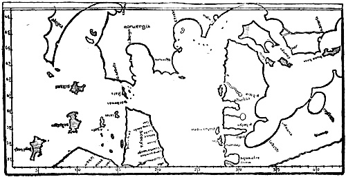
Scandinavia on the map of Europe in the Medici Atlas (of 1351). The scales of latitude and longitude are here added from Ptolemy’s maps. The network of compass-lines is omitted
The south coast of Norway [with “Stauanger”] and the southern point of Greenland retained on Clavus’s map the same relation of latitude, a difference of 1½°, as the corresponding localities on the Medici map, with very nearly the same degrees of latitude as on the latter, if we there employ a scale of latitude calculated upon this map’s representation of Spain (the Straits of Gibraltar) and France (Brittany), and use Ptolemy’s latitudes for these countries. This has been done in the reproduction of the Medicean mappamundi on p. 236.[255] The scale of longitude is calculated in the same proportion to the latitude as in Ptolemy. In some tract like that included in the fourth part of the “Rymbegla” [1780, p. 466] Clavus may have found that Bergen lay in latitude 60° and so placed the town on the west coast of Norway in this latitude according to his own scale (on the right-hand side of the Nancy map, see p. 474). In relation to the south coast of Norway Bergen was thus brought ¾° farther south than “c. bergis” on the Medici map (above). Calculated according to Ptolemy’s scale of latitude (on the left-hand side of the Nancy map), Bergen was consequently placed in Clavus’s text in 64°, while the southern point of Greenland is placed in 63° 15′,[256] a difference in latitude of 45′ (in the Vienna text the difference is 35′), while in reality it is 38′; a remarkable accidental agreement. According to Clavus’s own scale of latitude on the right-hand side of the Nancy map, we get the following latitudes: Bergen 60°, the southern point of Greenland 59° 15′, Stavanger 58° 30′. In reality the latitudes of these places are: 60° 24′, 59° 46′, and 58° 58′. This agreement is remarkable, as a displacement of the scale of latitude half a degree to the north on the Nancy map would give very nearly correct latitudes.[257] The mutual relation between the latitudes of the three places may, as we have seen, be explained from the Medici map, but hardly from a possible acquaintance with the Icelandic sailing directions; for according to these Bergen and the southern point of Greenland would be placed in the same latitude, since we are told that from Bergen the course was “due west to Hvarf in Greenland.”[258] The Medici map may also give a natural explanation of places like Bergen and the southern point of Greenland having been given by Clavus a latitude so much too northerly (even in the Nancy map), and of the southern point of Greenland having only half a degree more westerly longitude than the west coast of Ireland.[259]
Iceland lay, according to the Bruges itinerary, midway between Norway and Greenland, precisely as on the Nancy map. Between Norway and Iceland, according to the same itinerary, lay “Fareö” [Færö], and the fabulous island “Femöe,” “where only women are born and never men.”
After speaking of the “third headland” in 71° on the east coast of Greenland, the Nancy text goes on:
“But from this headland an immense country extends eastward as far as Russia. And in its [i.e., the country’s] northern parts dwell the infidel Karelians (‘Careli infideles’), whose territory (‘regio’) extends to the north pole (‘sub polo septentrionalis’) towards the Seres[260] of the east, wherefore the pole [‘polus’ == the arctic circle ?], which to us is in the north, is to them in the south in 66°.”
It is probable, as suggested by Björnbo and Petersen, that these “Careli infideles” are identical with those who are found almost in the same place, in the ocean to the north of Norway, on one of the maps in Marino Sanudo’s work (in the Paris MS., see above, p. 225), and who on other maps belonging to that work are placed on the mainland to the north-east of Scandinavia. As pointed out by Storm, “Kareli” are also mentioned together with Greenland and “Mare Gronlandicum” in the Bruges itinerary.
Björnbo and Petersen maintain that Claudius Clavus has here consciously put forward a new and revolutionary view which was a complete break with the cosmogony of the whole of the Middle Ages, since according to the latter the disc of the earth was entirely surrounded by sea to the south of the North Pole, as represented on the wheel-maps. I think this is attributing to Clavus rather too much original thought, of which his maps and text do not otherwise give evidence. It is, of course, correct that the idea of land, and inhabited land, too, at the North Pole, or to the north of the Arctic Circle, did not agree with the general learned conception of the Middle Ages; but the same idea had already been clearly enough expressed in Norwegian-Icelandic literature. Even the Historia Norwegiæ has inhabited land beyond the sea in the north, and the Icelandic legendary sagas and Saxo have it too. In addition to these, the tract included in the “Rymbegla” says distinctly (see above, p. 239) that this land in the opinion of some lies under the pole-star (cf. Clavus’s expression: “sub polo septentrionalis”). The fact that the continent on the Medicean map of the world extended boundlessly on the north into the unknown (whereas Africa ended in a peninsula on the south) must have confirmed Clavus in the view that the land reached to the pole. To this was added, what perhaps weighed most with him, the fact that such a view did not conflict with Ptolemy, whose continent also had no limit on the north.
On the connecting land in the north is written, on the Nancy map: “Unipedes maritimi,” “Pigmei maritimi,” “Griffonii regio vastissima,” and “Wildhlappelandi.” As these names are not mentioned in Clavus’s text, it is uncertain whether the fabulous creatures may not be to some extent additions for which he is not responsible.
After the map was drawn, with its bays and headlands, and the coast of Scandinavia provided with a suitable number of islands, Claudius Clavus set himself to describe it; where he had no names from earlier sources, he numbered the headlands, bays and islands, “Primum,” “Secundum,” etc.
A remarkable thing about the Nancy map is that it has two divisions of latitude: one according to Ptolemy on the left-hand side of the map, and another according to Clavus himself, on a scale four degrees lower, on the right-hand side. According to the latter, Roskilde would have a longest day of seventeen hours (through a transposition the Nancy map gives seventeen hours thirty minutes), which, as pointed out by Björnbo [1910, p. 96], exactly agrees with what Clavus may have learnt from a Roskilde calendar (“Liber daticus Roskildensis”) of 1274. Björnbo has also remarked that Bergen is given a remarkably correct latitude, 60° (the correct one is 60° 24′), and thinks it possible that there may have been a Bergen calendar which Clavus has used. But a more likely source, unnoticed by Björnbo, is to be found, as mentioned on p. 260, in the “Rymbegla” tract, where the latitude of Bergen is given as 60°. It is true that the same tract gives the latitude of Trondhjem (Nidaros) as 64°, which does not agree with the Nancy map, where there is a difference of only 2° between Bergis and Nidrosia. Even though it is probable that Clavus was acquainted with some such tract, with which his statement as to land at the North Pole also agrees, it may have been a somewhat different version from that which found its way into the “Rymbegla,” and perhaps the latitude of Trondhjem was not mentioned there. On the other hand, he may have found, there or elsewhere, the latitude of Stavanger given, 1½° farther south than Bergen (?).
If we assume that Clavus, even in the construction of his first map, made use of the Medicean map of the world, and that his Greenland is the most westerly peninsula of the latter’s Norway, it will seem strange that he did not also draw the west coast of that peninsula, which would naturally become the west coast of Greenland. It is true that the Nancy map is only a copy, but as the west coast of Greenland is not mentioned in the copy of Clavus’s text either, we are bound to believe that he did not include it. The margin on the western side of Clavus’s first map was evidently determined by that of Ptolemy’s map of the British Isles, and follows precisely the same meridian. Thus there was no room for the Medici map’s peninsula corresponding to Clavus’s Greenland. As already stated, it is difficult to get away from the belief that the Medici map was used for the east coast of Greenland, the south coast of Norway, etc.; the resemblances are too great, and otherwise inexplicable (cf. p. 261, note 3).
Clavus’s later map and text, and their genesis
After the first map was drawn, Clavus may have made further cartographical studies in Italy, and may thus have become acquainted with other compass-charts, especially those of the Dalorto type. At the same time he may have obtained a new and more accurate determination of the latitude of Trondhjem, probably by the length of its longest day. As Trondhjem was an archbishopric, it is not unlikely that he found such a piece of information in the papal archives at Rome. He may then naturally have wished to bring his map more into agreement with his new knowledge, and this may have led to his later map, which is now known to us through several somewhat varying copies. To this he then wrote a new text (the Vienna text), which in all important points resembles the former, but has various additions and alterations. The later map has not the double scale of latitude on any of the copies known, but curiously enough only Ptolemy’s degrees. Besides a more accurate delineation of Jutland and the Danish islands, especially Sealand, Bornholm and Gotland are drawn in closer resemblance to the Medici map; the south coast of Scandinavia has been altered to agree more with compass-charts of the Catalan type. In particular the south coast of Norway has been given the four characteristic promontories (as on the Dalorto map of 1339, and on the Modena map, etc.; cf. the reproductions, pp. 226, 231), and Bergen (“Bergis”) has been placed at the head of the westernmost of the three bays thus formed, which is also a peculiarity of the maps of this type (the Catalan chart of 1375 has five promontories with four bays, cf. Nordenskiöld, 1896, Pl. XI.). The other two diocesan towns, Stavanger and Hamar, are placed at the heads of the other two bays to the east, and Stavanger has thus lost the remarkably correct position in relation to Bergen and the south point of Greenland which it had on the older map. Trondhjem has been placed at the extremity of the westernmost promontory, possibly because there had been found a more correct determination of the latitude of the town, which was to be fitted into Ptolemy’s graduation; thereby the shape of Norway has become still narrower and farther removed from reality.
From the “lac scarsa” (Lake Skara, i.e., Vener) with its river is derived the great lake “Vona” (Vener) in the centre of Scandinavia on all the copies of Clavus’s later map, from which the river “Vona” (also mentioned in the Vienna text) runs into the deep bay by “Aslo” (Oslo) and the island of “Tunsberg.” A connection, especially with Dalorto’s map of 1339, seems again to be implied by Clavus’s statement in the Vienna text that on Lister Ness “white falcons are caught” (“Liste promontorium, ubi capiuntur falcones albi”). On Dalorto’s map there is a picture of a white falcon on the headland to the west of that which Clavus has made into Lister, and the words “hic sunt girfalcos” (here are hunting falcons). That Clavus has moved the hawks to a headland farther east is of small importance. Either he may have taken his hawks from Dalorto’s or a similar map, or else they are derived from an older common source.
Through the alteration of the south coast of Norway, it became necessary to separate it from Thule, which again became an island as originally in Ptolemy; but on the copies of the map it has in addition the name “Bellandiar,” which may be a corruption of Hetlandia (Shetland). The north-west coast of Norway has also been given a form which agrees better with the compass-charts, although it has a much more east-north-easterly direction than even on the Modena map; but this was, of course, necessary to make room for the sea “Nordhenbodnen” (Nordbotn). That the compass-charts might lead to something resembling Clavus’s last form of Scandinavia, and especially of the south coast of Norway, is shown by the map of Europe in Andrea Bianco’s atlas of 1436, which must have been drawn without knowledge of Clavus’s work. If on this map we move the coast of the Baltic farther south and Skåne also, which would be necessitated by a better knowledge of Denmark (and by the alteration of the map following Ptolemy), and draw the coast-line of Norway towards the east-north-east from the south-western promontory (instead of making it go in a northerly direction), we shall get a Scandinavia of very similar type to that in Clavus’s later map.
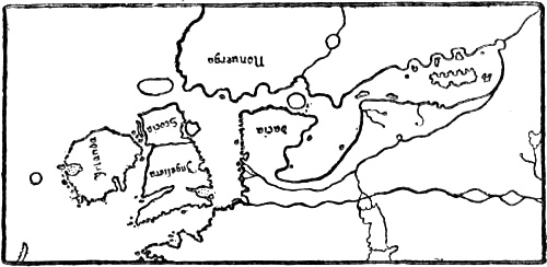
The north-western portion of the map of Europe in Andrea Bianco’s atlas of 1436. The compass-lines are omitted
Björnbo and Petersen have maintained in their monograph that Clavus must have been in Norway before he drew this map, and that amongst other things his remarkably correct latitude for Trondhjem must be due to his own observation of the length of the day at the summer solstice. Storm [1889, p. 140] seems also to have supposed that Clavus may really have been in Norway. To me it appears that his map and text are conclusive evidence against his ever having been there; for a man who had sailed to Trondhjem along the coast of Norway could not possibly have produced a cartographical representation of the country so entirely at variance with reality as Clavus has done, however ignorant we may suppose him. The fact in itself that “Trunthheim” (Trondhjem) or “Nedrosia” is placed at the extremity of the south side of the south-western promontory of the country is extraordinary. If he had come there asleep he could not have got any such idea; and for a man who had sailed in through the long channel of the Trondhjem fjord up to the town it is incredible. It is equally incredible that a man who had sailed along the coast from Stavanger and Bergen to Trondhjem could place the latter town in a latitude 10′ to the south of Bergen, and only 10′ to the north of Stavanger. We are not justified in attributing to Clavus such an entire lack of power of observation, especially if we are to suppose him capable of determining with remarkable accuracy the length of the longest day at Trondhjem. That Trondhjem is placed to the west of Bergen and Stavanger, that the Dovrefjeld is called a high promontory, while on the Nancy map it was inland, that Hamar (“Amerensis”) is put on the sea-coast, etc., all shows the same want of knowledge of the country and its configuration. The names he may have taken from an itinerary or other sources, and, as already suggested, it is not unlikely that he may have found in the papal archives a fairly correct statement of the latitude (or length of the longest day) of Trondhjem, which was an archbishop’s see. That the towns he gives are just those that are the heads of dioceses is perhaps an indication of a connection with the Vatican.
Clavus tells us further that
“Norway has eighteen islands, which in winter are always connected with the mainland, and are seldom separated from it, unless the summer is very warm,” and that “‘Tyle’ [Thule] is a part of Norway and is not reckoned as an island, although it is separated from the land by a channel or strait, for the ice connects it with the land for eight or nine months, and therefore it is reckoned as mainland. The same applies to the sea ‘Nordhinbodnen’ [Nordbotn], which separates ‘Wildlappenland’ from ‘Vermenlandh’[261] and ‘Findland’ by a long strait, since the countries are united by almost eternal ice.”
This discloses an extraordinary lack of knowledge of Northern conditions. Such a connection of the islands with the mainland by ice occurs, of course, nowhere on the whole outer coast of Norway from Færder to the Murman Coast. On the other hand, the Gulf of Bothnia and the Åland archipelago are frozen over for a long time in winter, and it might be supposed that Clavus had heard reports of this. But I have not been able to discover any source from which he may have derived these fables. Most probably they are embellishments of the same kind as the eighteen islands of Norway, that form an arbitrary decoration of the coast-line of his map, a circumstance which does not hinder him from describing them as real. Clavus has used the ice as a transition between the representation of his older map, where Thule was part of the mainland, and that of the later one, where it was made into an island.
At the northernmost limit of Norway, between two places called “Ynesegh” and “Mestebrodh,” Clavus connected the Polar Sea (“Nordhinbodhn”) by a narrow channel with the Gotland Sea [the Baltic], and a little farther north, in 67°, he says that
“the uttermost limit is marked with a crucifix, so that Christians shall not venture without the king’s permission to penetrate farther, even with a great company.” “And from this place westwards over a very great extent of land dwell first Wildlappmanni [Wild Lapps, i.e., Mountain Lapps, Reindeer Lapps ? cf. vol. i. p. 227], people leading a perfectly savage life and covered with hair, as they are depicted; and they pay yearly tribute to the king. And after them, farther to the west, are the little Pygmies, a cubit high, whom I have seen after they were taken at sea in a little hide-boat, which is now hanging in the cathedral at Nidaros; there is likewise a long vessel of hides, which was also once taken with such Pygmies in it.”
Two things are to be remarked about this assertion that he himself had seen these Pygmies (one might suppose in Norway): (1) if he had really seen a captive Eskimo brought to Norway (by whom ?), he could hardly have been ignorant that this remarkable native was from Greenland, and not from a fabulous northern land. And (2), how could he then give their height as no more than a cubit, like the Pygmies of myth? It appears to me that in one’s zeal to defend Clavus, one would thus have to attribute to him two serious falsehoods, instead of a more innocent rhetorical phrase about having seen this, that, and the other.
Clavus’s statement about the Pygmies’ small hide-boats, and the long hide-boat, that hung in Trondhjem cathedral, is, however, of great interest from the fact that this is the first mention in literature of the two forms of Eskimo boat: the kayak and the women’s boat (“umiak”). Perhaps he got this from the same unknown source (in the Vatican ?) in which he found the statement of the latitude of Trondhjem (?). In the fact that the Wild Lapps are mentioned first, and after them the Pygmies, Clavus’s text again bears a great resemblance to the anonymous letter to Pope Nicholas V. (of about 1450). In the northernmost regions (to the north-west of Norway) this letter mentions [cf. Storm, 1899, p. 9]
“the forests of Gronolonde, where there are monsters of human aspect who have hairy limbs, and who are called wild men.”... “And as one goes west towards the mountains of these countries, there dwell Pygmies,” etc. (cf. above, p. 86).
Michael Beheim also mentions “Wild lapen,” who live in the forests to the north of Norway, and who carry on a dumb barter of furs with the merchants, like that described by the Arab authors as taking place in the country north of Wîsu (cf. p. 144), and he goes on to speak of the Skrælings, three spans high, etc. (cf. above, p. 85). Beheim’s statement differs from Clavus’s text, and this again from the letter to Nicholas V., so that one cannot be derived from the other. It is therefore most probable, as suggested already (p. 86), that they have all drawn from some older source, and it may be supposed that this was Nicholas of Lynn. We have seen that there are other points in Clavus that lead one’s thoughts in the same direction.
Clavus proceeds:
“The peninsula of the island of Greenland stretches down from land on the north which is inaccessible or unknown on account of ice. Nevertheless, as I have seen, the infidel Karelians daily come to Greenland in great armies (bands of warriors, ‘cum copioso exercitu’), and that without doubt from the other side of the North Pole. Therefore the ocean does not wash the limit of the continent under the Pole [Arctic Circle ?] itself, as all ancient authors have asserted; and therefore the noble English knight, John Mandevil, did not lie when he said that he had sailed from the Indian Seres [i.e., China ?] to an island in Norway.”
If we compare this with the “Rymbegla” tract already mentioned [1780, p. 466], we see that these are much the same ideas as there expressed. We read there
“that it is the report of the same men that the sea is full of eternal ice to the north of us and under the pole star, where the arms of the Outer Ocean meet....”
When it is there stated that
“those shores [under the pole star] hinder the ring of the ocean from coming together [i.e., round the earth]” ... and “that one can go on foot ... from Greenland to Norway” [cf. above, p. 239],
this is evidently something similar to what Clavus says; but the latter’s words as to the voyage which he attributes to Mandeville from the Indian Seres to Norway being more probable because there is land at the North Pole are somewhat incomprehensible.
John Mandeville’s book about a voyage through many lands to the far east and China dates from between 1357 and 1371, and is put together from various accounts of voyages, with the addition of all kinds of fables. Mandeville does not himself claim to have made any such voyage from China to Norway; on the other hand, he has much to say, in chapter xvii., about the possibility of sailing round the world, which he declares to be practicable, and if ships were sent out to explore the world, one could sail round the world, both above and below. He says that when he was young he heard of a man who set out from England to explore the world, and who went past India and the islands beyond it where there are more than five thousand islands, and so far did he travel over sea and land that he finally came to an island where he heard them calling to the ox at the plough in his own language, as they did in his own country. This island afterwards proved to be in Norway.[262]
Clavus’s assertion that he himself saw (“ut uidi”) Karelians in Greenland is impossible. As it is expressly stated that there was land at the North Pole, and as it is not mentioned that these Karelians had hide-boats like the Pygmies, the meaning must be that their armies came marching by the land route, which, of course, is an impossibility, which, if he had been in Greenland, would make him a worse romancer than if we suppose his “ut uidi” to mean that he had seen something of the sort stated in a narrative; but even this may be doubtful. In the Bruges itinerary [cf. Storm, 1891, p. 20] or some similar older authority, which we know he may have used, he may have seen “Kareli” beyond Greenland spoken of as “in truth a populus monstrosus.” We have already said that on the maps accompanying Marino Sanudo’s work he may have seen “Kareli infideles” marked on the mainland to the north-east of Norway, or even on an island out in the northern sea, and he would then naturally have connected the Karelians of the itinerary with these Karelians north of Norway. If we add to this that on the Medicean map of the world he saw the mass of the continent extending from Scandinavia and the peninsula corresponding to Greenland, northwards into the unknown, and that in the “Rymbegla” tract he saw mention of land at the North Pole—then, indeed, his whole statement seems to admit of a perfectly natural explanation.
His lack of knowledge of the conditions in Greenland appears again in his speaking of Pygmies and Karelians as two different peoples, one apparently on the sea, and the other marching in armies on land; and in his mentioning hide-boats as something peculiar to the former in the fabulous northern country, while he does not say that the Karelians in Greenland had boats or went to sea. If he had only spoken to people who had been in Greenland, he could hardly have avoided hearing of the Skrælings who come to meet every traveller in their hide-boats.
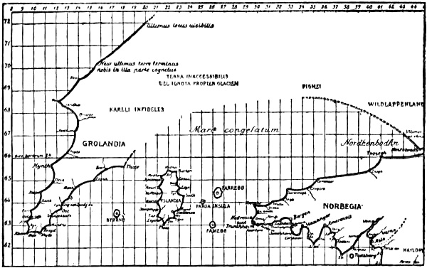
Map constructed by Dr. Björnbo after Clavus’s later description (the Vienna text). (Björnbo and Petersen, 1904, Pl. II.)
Clavus’s west coast of Greenland taken directly from the Medici map
It is an important difference between Clavus’s first and second maps (and also between his first and second texts) that on the latter Greenland is given a west coast. Its form bears an altogether striking resemblance to the west coast of the corresponding peninsula on the Medicean mappamundi, so that there can be no doubt that this coast is copied from it.[263] This is notably the case if we confine ourselves to Björnbo and Petersen’s reconstruction of the coast after the text of Clavus, from which it appears plainly enough that there are the same number of bays as on the Medici map; they are closest together near the southern point of the country; then come two larger bays to the north, then a very broad bay, longer than the two others together, and then a straighter coast-line to the north of that (cf. p. 236). The east coast of Greenland has in part been provided with corresponding bays, although this coast is almost straight on the Medici map; but this answers to the north coast of Scandinavia on the Nancy map having very nearly the same indentations as the south coast. In taking the Medici map as the foundation of Clavus’s Greenland coast we also have a natural explanation of the relation between his distribution of names on the east coast and the west. In his later text it is striking that his description of the east coast of Greenland does not reach farther than to his “Thær promontorium” in 65° 35′, while the description of the west coast goes as far north as 72°. This might seem to be connected with real local knowledge, since the latitude 65° 35′ on the east coast agrees in a remarkable way with the latitude of Cape Dan, 65° 32′, where the coast turns in a more northerly direction. To the north of this the coast is usually blocked with ice, and this place has therefore frequently been given as the northern limit of the known east coast, and probably it was there that the Icelanders first arrived off the land on their voyage westward to the Greenland settlements. But this is one of those accidental coincidences that sometimes occur, and that warn us to be careful not to draw too many conclusions from evidence of this nature.[264] We find the explanation in the Medici map (p. 236), where the east coast of the peninsula corresponding to Greenland does not go farther north than to about the same latitude as the promontory on the south side of the broad bay already referred to on the west coast, which promontory Clavus calls “Hynth” [“Hyrch”]; it lies in 65° 40′. As Clavus’s coast from this point of the east coast northward had no map to depend on, he did not venture to go farther in his description this time, though in the Nancy text he goes to 71° with his northernmost cape.
The Medicean map of the world gives us at the same time a simple explanation of Clavus’s designations for the two most northerly points on the west coast of Greenland. If we confine ourselves to the scale of latitude for the Medici map, which, as stated above (p. 259), we have found by using Ptolemy’s latitudes for more southern places on the map (Gibraltar and Brittany), and which is inserted in the left-hand margin of the reproduction, p. 236, we shall find the following: just at the spot of which Clavus declares: “New, the uttermost limit of the land which we know on this side, lies in 70° 10′,”[265] the heavy colouring of the land on the Medici map comes to an end (judging from the photograph in Ongania, Pl. V.). Farther to the north extends the coast of the lightly coloured mass of land; but just at this point, in 72°, where Clavus has his “ultimus locus uisibilis” [last point visible][266] this coast-line disappears into the oblique frame which cuts off the upper left-hand corner of the map. The agreement is here so exact and so complete that it would be difficult to find any way out of it.
The position of Iceland
Björnbo and Petersen have asserted that Iceland, on the later map and in the Vienna text, has been given a position more in agreement with the sailing directions than on the Nancy map. I cannot see the necessity for this supposition, as it has almost exactly the same position in relation to the southern point of Greenland and to Norway in both works; the chief difference is merely that the longitude of all three countries is made 3° farther east in the later work (and the latitude of the southern points of Iceland and Greenland is put somewhat farther south), and that the east coast of Greenland has a more oblique north-eastward direction than the corresponding north-east coast on the Medici map, with the direction of which the Nancy map agrees fairly well. In this way it is brought nearer to Iceland; but that this should be due to a knowledge of the sailing directions seems very uncertain, and is not disclosed, so far as I can see, elsewhere in the later work. The only things I have found which might possibly point to northern authorities having been consulted since the production of the Nancy work, are the accurate latitude of Trondhjem, already referred to, and the island of “Byörnö” between Iceland and Greenland. The latter might be the Gunnbjörnskerries (or Gunnbjarnar-eyar) mentioned, amongst other places, in Ivar Bárdsson’s description of Greenland; but the abbreviation of the name is curious. Perhaps the island may be due to some oral communication, or an erroneous recollection of something the author may have heard of in Denmark in his youth.
Clavus’s merits
On the whole we shall be compelled after all to detract considerably from Claudius Clavus’s reputation as a Northern traveller and cartographer. His journey did not extend farther north than the Danish islands, and perhaps Skåne. On the other hand, he was in Italy, where he drew his maps or had them drawn, and where he also found his most important authorities. His chief merit as a cartographer is that he is the first we know of to have adopted Ptolemy’s methods, and that he gave the name of Greenland to the westernmost tongue of land in Norway on the Medicean mappamundi, and altered this a good deal with the help of other compass-charts and Vesconte’s mappamundi, to make it agree better with the ideas of the North which he may have acquired to some extent in his youth through legendary tales, and later through Saxo and other writers.
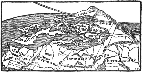
North-western portion of Nicolaus Germanus’s first revision of Ptolemy’s map of the world (after 1466). (J. Fischer, 1902, Pl. I.)
Clavus’s influence on later cartography Nicolaus Germanus, circa 1460-1470
Claudius Clavus’s later map of the North exercised for a long period a decisive influence on the representation of Scandinavia and to some extent of Greenland. This was chiefly due to the two well-known cartographers, Nicolaus Germanus and Henricus Martellus.[267] The former must have become acquainted with Clavus’s map soon after 1460, and included copies of it in the splendid MSS. of Ptolemy’s Geography which proceeded from his workshop at Florence. In these copies, of which several are known (cf. p. 251), he has redrawn Clavus’s map in the trapezoidal projection invented by himself, whereby his Greenland has been given a more oblique position than the Greenland of the original map and the corresponding peninsula on the Medici map. He also introduced this Greenland into his map of the world [cf. J. Fischer, 1902, Pl. I., III.; Björnbo, 1910, p. 136]; but, in order to make it agree better with the learned mediæval view of the earth’s disc surrounded by ocean, he surrounded it by sea on the north, so that it came to form a long and narrow tongue of land projecting from northern Russia, instead of the northern mass of land extending to the North Pole according to Clavus. But this long peninsula does not seem to have entirely satisfied this priest’s erudite ideas of the continent, and on later maps (which were printed after his death in the Ulm editions of Ptolemy of 1482 and 1486) he shortened it so much that it became a rounded peninsula to the north of Norway, with the name “Engronelant,”[268] and at the same time he moved Iceland out into the ocean to the north-west. This apparently quite arbitrary alteration may perhaps be due to a desire to bring the map as far as possible into agreement with the learned dogma of the continent [cf. Björnbo, 1910, pp. 141, ff.]; but older conceptions of Greenland may also have contributed towards it [cf. J. Fischer, 1902, pp. 87, ff.]. We have already seen that Adam of Bremen regarded Greenland as an island “farther out in the ocean opposite the mountains of Suedia” (see vol i. p. 194), and in his additions to the copy of Ptolemy, Cardinal Filastre (before 1427) states that Greenland lay to the north of Norway; we find the same view in the letter of 1448 from Pope Nicholas V. (see above, p. 113).[269] It is also somewhat remarkable that on the Genoese mappamundi of 1447 (or 1457) there occurs a peninsula north of Scandinavia just at the place where Clavus’s Greenland should begin (see p. 287).[270] On Fra Mauro’s mappamundi (1457-59) there are several peninsulas to the north of Scandinavia, some of which proceed from Russia (see p. 285).
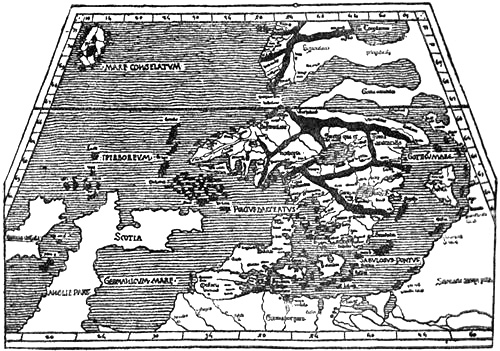
Map of the North by Nicolaus Germanus (before 1482), after Claudius Clavus, but with Greenland transferred to the north of Norway
Henricus Martellus, circa 1490
The cartographer Henricus Martellus, who succeeded Nicolaus Germanus, again adopted Clavus’s form of Greenland, wholly or in part, on his maps dating from about 1490.
In this way there arose on the maps of the close of the Middle Ages two types of the North: one with Greenland in a comparatively correct position to the west of Iceland, though far too near Europe and connected therewith, and another type with “Engronelant” as a peninsula to the north of Norway. The latter remained for a long time the usual one in all editions of Ptolemy, in other cartographical works and on many globes. After the rediscovery of Greenland we even get sometimes two delineations of this country on the same map, one to the north of Norway and the other in its right place in the west.
Illa verde
Greenland seems to have been given a wholly different form on a Catalan compass-chart from Majorca, of the close of the fifteenth century, where in the Atlantic to the west of Ireland and south-west of Iceland [“Fixlanda”] there is an island called “Illa verde” [the green isle]. It seems, as assumed by Storm [1893, p. 81], that the name must be a translation of Greenland, which is called in the Historia Norwegiæ “Viridis terra.” The representation of Iceland [“Fixlanda”] on this map is incomparably better than on all earlier maps, and gives proof of new information having come from thence. As the place-names point to an English source, it is possible that the cartographer may have received information from Bristol, which city was engaged in the Iceland trade and fisheries, and his island, “Illa verde,” may be due to an echo of reports about the forgotten Greenland in the west. It is worth remarking that the island is connected with the Irish mythical “Illa de brazil,” which lay to the west of Ireland and which appears in this map twice over in its typical round form (cf. above, p. 228).[271] If we remember that this happy isle is in reality the Insulæ Fortunatæ, and that in the Historia Norwegiæ (see above, p. 1) it is said that Greenland [“Viridis terra”] nearly touches the African Islands (i.e., Insulæ Fortunatæ), then we possibly have an explanation of this juxtaposition. But as it is said in the same passage that Greenland forms the western end of Europe, we cannot suppose that the cartographer was acquainted with this work. The probability is, no doubt, that Greenland [Illa verde] together with Brazil or the Insulæ Fortunatæ had become transformed into mythical islands out in the ocean.
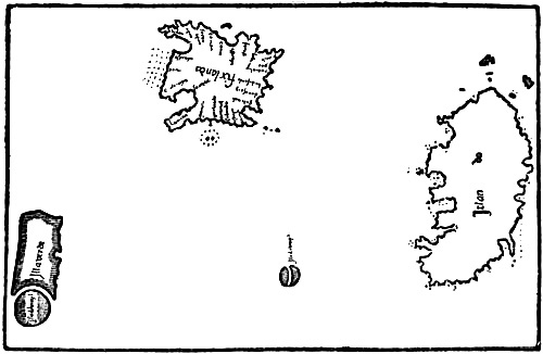
Part of a Catalan compass-chart of the fifteenth century, preserved at Milan. (Nordenskiöld, 1892, Pl. 5)
On another compass-chart, bound up in a Paris MS. of Ptolemy of the latter part of the fifteenth century, a similar island (or peninsula ?), with the same round island to the south of it, is seen to project southwards from the northern border of the chart out into the Atlantic, and a little farther east than the Insulæ Fortunatæ. On the island is written: “Insula uiridis, de qua fit mentio in geographia” [the green island, of which mention is made in the geography].[272] We do not know what geographical work may here be meant; Björnbo suggests that it might be the lost work of Nicholas of Lynn, who again may have used the Historia Norwegiæ. It is striking that the island, besides being connected with a round island like Brazil, but without a name, is placed on this map near the Insulæ Fortunatæ.
This “green island,” which thus is probably a remnant of old Greenland, occurs again in various forms and in various places on many sixteenth-century maps.
Lascaris’s journey to Norway and Iceland, fifteenth century
It is not surprising that information about the northern lands made its appearance also on the maps of this time, as we know that the North was visited more frequently, and sometimes by eminent southerners, from the year 1248, when the well-known Matthew Paris, who, amongst other things, drew a map of England remarkable for his time, visited Norway. Rather is it strange that the direct knowledge thus obtained did not leave more definite traces. Early in the fifteenth century (some year between 1397 and 1448) a Byzantine, Cananos Lascaris, travelled in the North and wrote about it (in Greek). He mentions amongst other things that in Bergen, the capital of Norway (“Bergen Vagen”), money was not used in trading [this must have been due to scarcity of coin]; but in Stockolmo, the capital of Sweden, they had money of alloyed silver. Bergen had a month of daylight from June 24 to July 25. He also says that he himself went to the land of the Ichthyophagi (fish-eaters), “Islanta,” from “Inglenia,” and stayed there for twenty-four days. The people were strong and powerfully built, they lived only on fish, and they had a summer day of six months [cf. Lampros, 1881].
Fifteenth-century maps of the world
It would take us too far here to attempt a mention of all the fifteenth-century maps which have a different representation of the North; but perhaps some of the mappemundi in wheel-form, which were still current at this time, ought to be referred to. We saw that on Vesconte’s map of the world accompanying Marino Sanudo’s work the coast-lines of the compass-charts in the Mediterranean, etc., had already been introduced. On the Modena map (p. 231) this has also been carried out as regards the North. In the fifteenth century we have various wheel-maps, of which some seem to be more antiquated. Lo Bianco’s round mappamundi, in his atlas of 1436, is connected with the compass-charts of that time. Johannes Leardus’s round mappamundi, in many editions of 1448 and earlier,[273] likewise shows a strong affinity to the compass-charts, although there is little detail in the delineation of the North. The same is the case with the anonymous round mappamundi in a codex in the Library of St. Mark at Venice [cf. Kretschmer, 1892, atlas, Pl. III., No. 13], but this map has also points of similarity to Vesconte’s mappamundi in Sanudo’s work, and, amongst other things, it has the same mountain-chain along the north coast of the continent, and the same form of the Baltic.
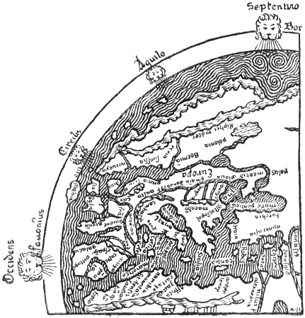
Europe on the mappamundi in the Geneva MS. of Sallust of about 1450. (The south should be at the top)
The round mappamundi in a MS. of Mela of 1417 at Rheims[274] is, on the whole, of a very antiquated type, but its image of the North seems more modern, and it has the same mountain-chain along the north coast of the continent as Vesconte’s map. The “Sallust” map at Geneva, of about 1450, is also antiquated, but its Baltic resembles the compass-charts, and the two mountain ridges, one along the north coast of the continent, the other parallel with it in the interior, strongly recall Vesconte’s map of the world. On the other hand, the connection by water between the Baltic and Mæotis (the Sea of Azov) is evidently derived from an earlier age (cf. p. 199). Out in the ocean to the north-west and west of Norway lie four islands. Björnbo supposes [1910, p. 75] that the two more northerly of these may correspond to Adam of Bremen’s Greenland and Wineland, but this must be very uncertain.[275]
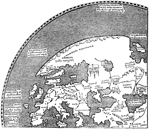
North-western portion of Andreas Walsperger’s mappamundi (of 1448). Most of the names are omitted. (The south should be at the top)
Walsperger’s map of 1448
A curious delineation of the North is found on the round mappamundi which was drawn at Constance in 1448 by the Benedictine monk Andreas Walsperger of Salzburg [cf. Kretschmer, 1891a]. The map is in most respects imperfect and antiquated, but shows also more recent, particularly German, influence.
The Mediterranean and the Baltic are disproportionately large, and the mass of land between them has been contracted. There are many mediæval mythical conceptions, and items showing possible influence by Adam of Bremen [cf. Miller, iii. 1895, p. 147]. Thus in northern Asia we have “Cenocephali” and Cannibals [“Andropophagi”], bearded women, Gog, Magog, etc. In Norway we read: “Here demons often show themselves in human shape and render service to men, and they are called trolls.” Claudius Clavus also speaks of trolls in Norway. In the northern ocean to the north-west of Norway is written: “In this great sea there is no sailing on account of magnets.” This is evidently the widely distributed mediæval myth of the magnet-rock, which attracted all ships with iron in them; in Germany it occurs in the legend of Duke Ernst’s wanderings in the Liver Sea, and it is doubtless derived from the Arabian Nights. On the mainland to the north-east of Norway we read that “here under the North Pole the land is uninhabitable on account of the excessive cold which produces a condition of continual frost....” In the extreme north of the ocean, near the Pole, is written: “Hell is in the heart or belly of the earth according to the opinion of the learned.”
“Palus meotidis” [the Sea of Azov] is marked as a lake due east of the Baltic. Along the north coast of Europe (and Norway) is indicated a ridge of mountains, somewhat similar to that in the Sanudo-Vesconte maps of the world. The delineation of Denmark (“dacia,” with “koppenhan” and “londoma,” i.e., Lund), the straight south coast of the Baltic, and a long-shaped island called “Suecia” (with “Stocholm” and “ipsala”) on the north, remind us a good deal of Edrisi’s map (p. 203), and also somewhat of the Cottoniana (vol. i. p. 183). To the north of the island of Suecia “the very great kingdom of Norway [‘Norwegie’]” projects to the west as a long peninsula bounding the Baltic, with “brondolch” [Bornholm ?] and “nydrosia metropolis” [the capital Nidaros] as towns on its south coast, and with the land of “Yslandia” [Iceland] and the town of “Pergen” [Bergen] on its extreme promontory.
The Borgia map, after 1410
Another peculiar type of the round mappamundi is the so-called Borgia map of the fifteenth century (after 1410). Its representation of Europe, with the Mediterranean on the southern side of the earth’s disc, is very imperfect and far removed from reality. The same is the case with its delineation of the North, but curiously enough its Scandinavia, which is different from that of the compass-charts, and in which Skåne forms a peninsula on the south, to the east of Denmark, has a greater resemblance to reality than that of other maps of this time. This map, too, has a chain of mountains along the north coast of the continent, as in the Vesconte maps [see Nordenskiöld, 1897, Pl. XXXIX.].
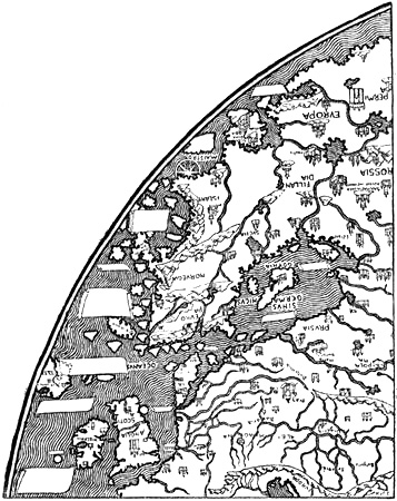
North-western portion of Fra Mauro’s mappamundi (of 1457-59), preserved at Venice. The legends and most of the names are omitted. (The south should be at the top)
Fra Mauro’s map, 1458
The best known fifteenth-century map of the world is that of Fra Mauro (1457-59), which is also drawn in wheel-form and is preserved at Venice. The coast-lines are taken to a great extent from the compass-charts, but a great deal of new matter has been added. As regards Norway, this consists of information from Querini’s voyage in 1432, as well as from other sources which are unknown to us; this is indicated by, amongst other things, an inscription on the sea to the north of Russia [“Permia”], which relates that a short time before two Catalan ships had sailed thither [cf. Vangensten, 1910]. On this map the Scandinavian Peninsula has been given a more reasonable extension to the north; but the west coast is very imaginatively supplied with peninsulas and islands, while the ocean outside is full of fabulous islands and contains many legends.
Denmark [“Datia”] has been made into an island (which is also called “Isola islandia”), and the Baltic [“Sinus germanicus”] has been widened into an inland sea with islands. In its northern part is a note that on this sea the use of the compass is unknown [cf. Vangensten, 1910]. Could this inscription be due to a misunderstanding like that on the Walsperger map in the ocean to the north-west of Norway, that it could not be navigated on account of magnets (cf. p. 283)? There is no hint of the name of Greenland on this map; on the other hand, Iceland appears in three or four different places: besides Denmark, as mentioned above, there is in northern Norway or Finland a peninsula named “Islant,” “where wicked people dwell, who are not Christians”; also a large island, “Ixilandia,” north-west of Ireland, and finally an intricate peninsula in the middle of Norway called “Isola di giaza” [i.e., the island of ice]. On the north of Norway or Finland a peninsula projects into the Polar Sea with the name of “Scandinabia.” The map does not contribute anything new of importance about the North, but points to a few fresh pieces of information about Norway, which are not to be traced in the older compass-charts; thus Bergen comes nearly in its right place on the west coast, and Marstrand appears to the east of Christiania fjord.
Genoese mappamundi, 1447
A picture of the North of a wholly different type is given on the elliptical Genoese mappamundi [of 1447 or 1457], which is still more fantastic than any of those hitherto mentioned. The Scandinavian Peninsula has a very long extension to the west, and ends in a promontory projecting northwards. To the north of this Scandinavia there is another fantastic peninsula where Lelewel thinks he can read the name “Grinland,” which is probably due to a misunderstanding, since, as pointed out by Björnbo [1910, p. 80], the name cannot be seen on the much-damaged original, or on Ongania’s photographic reproduction [Fischer-Ongania, Pl. X.]. Many imaginary islands are scattered about in the sea round these peninsulas.
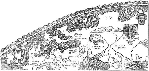
Northern Europe on the Genoese mappamundi of 1447 or 1457
Globes of the fifteenth century Behaim’s globe, 1492
Towards the close of the fifteenth century the discovery was made of representing the surface of the earth, with land and sea, on globes. It was evidently the efforts of Toscanelli that led to the general adoption of this mode of representation, which had been used by the Greeks at an early time (cf. vol. i. p. 78); in 1474 he announced that his idea of the western route to India could best be shown on a sphere. Columbus seems to have taken a globe with him on his voyage of 1492, according to his own words in the ship’s log. The oldest known terrestrial globe that is preserved was made in 1492 by the German Martin Behaim (born at Nuremberg in 1459).[276] He spent much time in Portugal, and also in the Azores, after making a distinguished marriage with a native of those islands, a sister-in-law of Gaspar Corte-Real’s sister. But it was during a visit to his native town (1490-93) that he constructed his globe. The sources of Behaim’s representation of the North were principally Nicolaus Germanus’s mappamundi in the Ulm editions of Ptolemy, of 1482 and 1486, where Greenland is placed to the north of Norway, and Marco Polo’s travels, which speak of the northern regions of Asia. Besides these a name like “tlant Venmarck” (the land of Finmark), for instance, points to a use of the same older authority as in the anonymous letter to Pope Nicholas V., of about 1450, where in the existing French translation there is mention of “lieux champestres de Venmarche” [the plains of Finmark].[277] Thus we are here again led to the lost work of Nicholas of Lynn, “Inventio fortunata” (1360), as the possible source. That it really was this work that was used seems also to result from the fact that the countries about the North Pole on Behaim’s globe bear a remarkable resemblance to Ruysch’s map of 1508, where this note is given at the North Pole:
“In the book ‘De Inventione fortunata’ it may be read that there is high mountain of magnetic stone, 33 German miles in circumference. This is surrounded by the flowing ‘mare sugenum,’ which pours out water like a vessel through openings below. Around it are four islands, of which two are inhabited. Extensive desolate mountains surround these islands for 24 days’ journey, where there is no human habitation.”
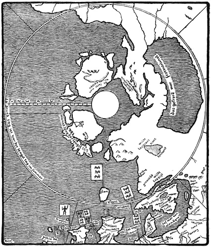
Northernmost Europe and the north polar regions on Behaim’s globe, 1492
What is new in Behaim’s picture of the North is chiefly this circle of land and islands around the North Pole, which he evidently took from Nicholas of Lynn, and which is not represented on any older map known to us. It consists of a continuous mass of land proceeding from his Greenland-Lapland to the north of Scandinavia, and extending eastward nearly to the opposite side of the Pole, where the Arctic Ocean (“das gefroren mer septentrional”) to the north of the continent becomes an enclosed sea. On the other side of the Pole are two large islands and a number of smaller ones. On one of the large islands is a picture of an archer in a long dress attacking a polar bear (which may be connected with myths about Amazons ?), and on the other side is written: “Hie fecht man weisen valken” [here they catch white falcons]. It might be supposed that this was derived from statements about Scandinavia or Iceland (cf. e.g., the legends of the compass-charts); but, as assumed by Ravenstein [1908, p. 92] and Björnbo [1910, p. 156], it is more likely to come from Marco Polo’s travels, where the Arctic coast of Siberia is spoken of. The many correct names, in a German form, in Martin Behaim’s Scandinavian North point to the possibility of his also having received oral information, though they may equally well be derived from older German maps.
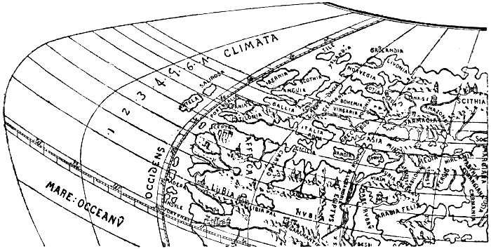
A portion of the Laon globe of 1493. (After d’Avezac.)
Laon globe, 1493
Almost contemporary with Behaim’s globe is the so-called Laon globe of 1493, which was accidentally discovered in a curiosity shop at Laon some years ago. It gives a wholly different representation of the North, more in agreement with the usual maps of the world of the Nicolaus Germanus type, with sea at the pole round the north of the continent, which terminates approximately at the Arctic Circle. The Scandinavian Peninsula (called “Norvegia”) has a form somewhat resembling this type; but to the north of it “Gronlandia” appears as an island, with a land called Livonia projecting northward on the east, and two islands, Yslandia and Tile, on the west. Nothing is known of the origin of the Laon globe, or of the sources of its representation of the North.
Such were the geographical ideas of the North at the close of the Middle Ages, when the period of the great discoveries was at hand; they were vague and obscure, and the mists had settled once more over large regions which had been formerly known; but out in the mists lay mythical islands and countries in the north and west.