Chapter I · (continued 5)
Reading edition
Jacob Roggewein, the Dutch Admiral, was more than any other navigator, willing to give himself the credit of making new discoveries, as the following extracts from the Journal of his expedition will evince. 'We looked for Hawkins's Maiden Land, but could not find it; but we discovered an Island 200 leagues in circuit, in latitude 52° S, about 200 leagues distant to the East of the coast of South America, which we named Belgia Austral.' That is as much as to say, Admiral Roggewein could not find Hawkins's Maiden Land; but he discovered land on the same spot, which he named Belgia Austral. Afterwards, proceeding in the same disposition, the Journal relates, 'We directed our course from Juan Fernandez towards Davis's Land, but to the great astonishment of the Admiral (Roggewein) it was not seen. I think we either missed it, or that there is no such land. We went on towards the West, and on the anniversary of the Resurrection of our Saviour, we came in sight of an Island. We named it Paaschen or Oster Eylandt (i. e. Easter Island).'
Paaschen or Easter Island according to modern charts and observations, is nearly 690 leagues distant from Copiapo, which is in the same parallel on the Continent of America. The statement of Davis and Wafer makes the distance only 512 leagues, which is a difference of 178 leagues. It is not probable that Davis could have had good information of the longitudes of the Galapagos Islands and Copiapo; but with every allowance, so large an error as 178 leagues in a run of 600 leagues might be thought incredible, if its possibility had not been demonstrated by a much greater being made by the same persons in this same homeward passage; as will be related. In the latitude and appearance of the land, the descriptions of Davis and Wafer are correct, Easter Island being a mountainous land, which will make partitions in the distant prospect and appear like a number of Islands.
Roggewein's claim to Paaschen or Easter Island as a new discovery has had countenance and support from geographers, some of the first eminence, but has been made a subject of jealous contest, and not of impartial investigation. If Roggewein discovered an Island farther to the West of the American coast than Davis's Land, it must follow that Davis's land lies between his discovery and the Continent; but that part of the South Sea has been so much explored, that if any high land had existed between Easter Island and the American coast, it could not have escaped being known. There is not the least improbability that ships, in making a passage from the Galapagos Isles through the South East trade-wind, shall come into the neighbourhood of Easter Island.
Edward Davis has generally been thought a native of England, but according to Lussan, and nothing appears to the contrary, he was a native of Holland. The majority of the Buccaneers in the ship, however, were British. How far to that source may be traced the disposition to refuse the Buccaneers the credit of the discovery, and how much national partialities have contributed to the dispute, may be judged from this circumstance, that Easter Island being Davis's Land has never been doubted by British geographers, and has been questioned only by those of other nations.
The merit of the discovery is nothing, for the Buccaneers were not in search of land, but came without design in sight of it, and would not look at what they had accidentally found. And whether the discovery is to be attributed to Edward Davis or to his crew, ought to be esteemed of little concern to the nations of which they were natives, seeing the discoverers were men outlawed, and whose acts were disowned by the governments of their countries.
Passing from considerations of claims to consideration of the fact;—there is not the smallest plea for questioning, nor has any one questioned the truth of the Buccaneers having discovered a high Island West of the American coast, in or near the latitude of 27° S. If different from Easter Island, it must be supposed to be situated between that and the Continent. But however much it has been insisted or argued that Easter Island is not Davis's Land, no chart has yet pretended to shew two separate Islands, one for Edward Davis's discovery, and one for Roggewein's. The one Island known has been in constant requisition for double duty; and must continue so until another Island of the same description shall be found.
1687. At the Island Juan Fernandez. Davis arrived at Juan Fernandez 'at the latter end of the year,' and careened there. Since the Buccaneers were last at the Island, the Spaniards had put dogs on shore, for the purpose of killing the goats. Many, however, found places among precipices, where the dogs could not get at them, and the Buccaneers shot as many as served for their daily consumption. Here again, five men of Davis's crew, who had gamed away their money, 'and were unwilling to return out of these seas as poor as they came in,' determined on staying at Juan Fernandez, to take the chance of some other buccaneer ship, or privateer, touching at the Island. A canoe, arms, ammunition, and various implements were given to them, with a stock of maize for planting, and some for their immediate subsistence; and each of these gentlemen had a negro attendant landed with him.
From Juan Fernandez, Davis sailed to the Islands Mocha and Santa Maria, near the Continent, where he expected to have procured provisions, but he found both those Islands deserted and laid waste, the Spaniards having obliged the inhabitants to remove, that the Buccaneers might not obtain supply there. The season was advanced, therefore without expending more time in searching for provisions, they bent their course Southward. They passed round Cape Horne without seeing land, but fell in with many Islands of ice, and ran so far Eastward before they ventured to steer a Northerly course, that afterwards, when, in the parallel of the River de la Plata, they steered Westward to make the American coast, which they believed to be only one hundred leagues distant, they sailed 'four hundred and fifty leagues to the West in the same latitude,' before they came in sight of land; whence many began to apprehend they were still in the South Sea[64], and this belief would have gained ground, if a flight of locusts had not alighted on the ship, which a strong flurry of wind had blown off from the American coast.
1688. Davis sails to the West Indies. They arrived in the West Indies in the spring of the year 1688, at a time when a proclamation had recently been issued, offering the King's pardon to all Buccaneers who would quit that way of life, and claim the benefit of the proclamation.
It was not the least of fortune's favours to this crew of Buccaneers, that they should find it in their power, without any care or forethought of their own, to terminate a long course of piratical adventures in quietness and security. Edward Davis was afterwards in England, as appears by the notice given of his discovery by William Dampier, who mentions him always with peculiar respect. Though a Buccaneer, he was a man of much sterling worth; being an excellent Commander, courageous, never rash, and endued in a superior degree with prudence, moderation, and steadiness; qualities in which the Buccaneers generally have been most deficient. His character is not stained with acts of cruelty; on the contrary, wherever he commanded, he restrained the ferocity of his companions. It is no small testimony of his abilities that the whole of the Buccaneers in the South Sea during his time, in every enterprise wherein he bore part, voluntarily placed themselves under his guidance, and paid him obedience as their leader; and no symptom occurs of their having at any time wavered in this respect, or shewn inclination to set up a rival authority. It may almost be said, that the only matter in which they were not capricious was their confidence in his management; and in it they found their advantage, if not their preservation.
CHAP. XVIII.
Adventures of Swan and Townley on the Coast of New Spain, until their Separation.
Swan and Townley. The South Sea adventures of the buccaneer Chief Davis being brought to a conclusion, the next related will be those of Swan and his crew in the Cygnet, they being the first of the Buccaneers who after the battle in the Bay of Panama left the South Sea. William Dampier who was in Swan's ship, kept a Journal of their proceedings, which is published, and the manuscript also has been preserved.
1685. August. Swan and Townley, the reader may recollect, were left by Edward Davis in the harbour of Ria Lexa, in the latter part of August 1685, and had agreed to keep company together Westward towards the entrance of the Gulf of California.
Bad Water, and Unhealthiness of Ria Lexa. They remained at Ria Lexa some days longer to take in fresh water, 'such as it was,' and they experienced from it the same bad effects which it had on Davis's men; for, joined to the unwholesomeness of the place, it produced a malignant fever, by which several were carried off.
September. On the Coast of New Spain. On September the 3d, they put to sea, four sail in company, i. e. the Cygnet, Townley's ship, and two tenders; the total of the crews being 340 men.
Tornadoes. The season was not favourable for getting Westward along this coast. Westerly winds were prevalent, and scarcely a day passed without one or two violent tornadoes, which were accompanied with frightful flashes of lightning, and claps of thunder, 'the like,' says Dampier, 'I did never meet with before nor since.' These tornadoes generally came out of the NE, very fierce, and did not last long. When the tornado was passed, the wind again settled Westward. On account of these storms, Swan and Townley kept a large offing; but towards the end of the month, the weather became settled. On the 24th, Townley, and 106 men in nine canoes, went on Westward, whilst the ships lay by two days with furled sails, to give them time to get well forward, by which they would come the more unexpectedly upon any place along the coast.
October. Townley proceeded, without finding harbour or inlet, to the Bay of Tecuantepeque, where putting ashore at a sandy beach, the canoes were all overset by the surf, one man drowned, and some muskets lost. Townley however drew the canoes up dry, and marched into the country; but notwithstanding that they had not discovered any inlet on the coast, they found the country intersected with great creeks not fordable, and were forced to return to their canoes. A body of Spaniards and Indians came to reconnoitre them, from the town of Tecuantepeque, to seek which place was the chief purpose of the Buccaneers when they landed. 'The Spanish books,' says Dampier, 'mention a large river there, but whether it was run away at this time, or rather that Captain Townley and his men were shortsighted, I know not; but they did not find it.'
October the 2d, the canoes returned to the ships. The wind was fresh and fair from the ENE, and they sailed Westward, keeping within short distance of the shore, but found neither harbour nor opening. They had soundings all the way, the depth being 21 fathoms, a coarse sandy bottom, at eight miles distance from the land. Island Tangola. Having run about 20 leagues along the coast, they came to a small high Island called Tangola, on which they found wood and water; and near it, good anchorage. 'This Island is about a league distant from the main, which is pretty high, and savannah land by the sea; but within land it is higher and woody.'—— Guatulco. El Buffadore, a spouting Rock. 'We coasted a league farther, and came to Guatulco, in latitude 15° 30′, which is one of the best ports in this Kingdom of Mexico. Near a mile from the mouth of the harbour, on the East side, is a little Island close by the main-land. On the West side of the mouth of the harbour, is a great hollow rock, which by the continual working of the sea in and out, makes a great noise, and may be heard a great way; every surge that comes in, forces the water out at a little hole at the top, as out of a pipe, from whence it flies out just like the blowing of a whale, to which the Spaniards liken it, and call it El Buffadore. Even at the calmest seasons, the beating of the sea makes the waterspout out at the hole, so that this is always a good mark to find the harbour of Guatulco by. The Harbour of Guatulco. The harbour runs in NW, is about three miles deep, and one mile broad. The West side of the harbour is the best for small ships to ride in: any where else you are open to SW winds, which often blow here. There is clean ground any where, and good gradual soundings from 16 to 6 fathoms: it is bounded by a smooth sandy shore, good for landing; and at the bottom of the harbour is a fine brook of fresh water running into the sea. The country is extraordinary pleasant and delightful to behold at a distance[65].'
There appeared to be so few inhabitants at this part of the coast, that the Buccaneers were not afraid to land their sick. A party of men went Eastward to seek for houses and inhabitants, and at a league distance from Guatulco they found a river, named by the Spaniards El Capalita, which had a swift current, and was deep at the entrance. They took a few Indians prisoners, but learnt nothing of the country from them. Vinello, or Vanilla, a Plant. On the 6th, Townley with 140 men marched fourteen miles inland, and in all that way found only one small Indian village, the inhabitants of which cultivated and cured a plant called Vinello, which grows on a vine, and is used to perfume chocolate, and sometimes tobacco.
The 10th, the canoes were sent Westward; and on the 12th, the ships followed, the crews being well recovered of the Ria Lexa fever. 'The coast (from Guatulco) lies along West and a little Southerly for 20 or 30 leagues[66].' Island Sacrificio. On account of a current which set Eastward, they anchored near a small green Island named Sacrificio, about a league to the West of Guatulco, and half a mile from the main. In the channel between, was five or six fathoms depth, and the tide ran there very swift.
Port de Angeles. They advanced Westward; but slowly. The canoes were again overset in attempting to land near Port de Angeles, at a place where cattle were seen feeding, and another man was drowned. Dampier says, 'We were at this time abreast of Port de Angeles, but those who had gone in the canoes did not know it, because the Spaniards describe it to be as good a harbour as Guatulco. It is a broad open bay with two or three rocks at the West side. There is good anchorage all over the bay in depth from 30 to 12 fathoms, but you are open to all winds till you come into 12 fathoms, and then you are sheltered from the WSW, which is here the common trade-wind. Here always is a great swell, and landing is bad. The place of landing is close by the West side, behind a few rocks. Latitude 15° N. The tide rises about five feet. The land round Port de Angeles is pretty high, the earth sandy and yellow, in some places red.' The Buccaneers landed at Port de Angeles, and supplied themselves with cattle, hogs, poultry, maize, and salt; and a large party of them remained feasting three days at a farm-house. The 27th, they sailed on Westward.
Some of their canoes in seeking Port de Angeles had been as far Westward as Acapulco. In their way back, they found a river, into which they went, and filled fresh water. Afterwards, they entered a lagune or lake of salt water, where fishermen had cured, and stored up fish, of which the Buccaneers took away a quantity.
Adventure in a Lagune. On the evening of the 27th, Swan and Townley anchored in 16 fathoms depth, near a small rocky Island, six leagues Westward of Port de Angeles, and about half a mile distant from the main land. The next day they sailed on, and in the night of the 28th, being abreast the lagune above mentioned, a canoe manned with twelve men was sent to bring off more of the fish. The entrance into the lagune was not more than pistol-shot wide, and on each side were rocks, high enough and convenient to skreen or conceal men. The Spaniards having more expectation of this second visit than they had of the first, a party of them, provided with muskets, took station behind these rocks. They waited patiently till the canoe of the Buccaneers was fairly within the lagune, and then fired their volley, and wounded five men. The buccaneer crew were not a little surprised, yet returned the fire; but not daring to repass the narrow entrance, they rowed to the middle of the lagune, where they lay out of the reach of shot. There was no other passage out but the one by which they had entered, which besides being so narrow was a quarter of a mile in length, and it was too desperate an undertaking to attempt to repass it. Not knowing what else to do, they lay still two whole days and three nights in hopes of relief from the ships.
It was not an uncommon circumstance among the Buccaneers, for parties sent away on any particular design, to undertake some new adventure; the long absence of the canoe therefore created little surprise in the ships, which lay off at sea waiting without solicitude for her return; till Townley's ship happening to stand nearer to the shore than the rest, heard muskets fired in the lagune. He then sent a strong party in his canoes, which obliged the Spaniards to retreat from the rocks, and leave the passage free for the hitherto penned-up Buccaneers. Dampier gives the latitude of this lagune, 'about 16° 40′ N.'
November. Alcatraz Rock. White Cliffs. River to the West of the Cliffs. They coasted on Westward, with fair weather, and a current setting to the West. On November the 2d, they passed a rock called by the Spaniards the Alcatraz (Pelican.) 'Five or six miles to the West of the rock are seven or eight white cliffs, which are remarkable, because there are none other so white and so thick together on all the coast. A dangerous shoal lies SbW from these cliffs, four or five miles off at sea. Two leagues to the West of these cliffs is a pretty large river, which forms a small Island at its mouth. The channel on the East side is shoal and sandy; the West channel is deep enough for canoes to enter.' The Spaniards had raised a breastwork on the banks of this channel, and they made a show of resisting the Buccaneers; but seeing they were determined on landing, they quitted the place; on which Dampier honestly remarks, 'One chief reason why the Spaniards are so frequently routed by us, though much our superiors in number, is, their want of fire-arms; for they have but few unless near their large garrisons.'
Snook, a Fish. A large quantity of salt intended for salting the fish caught in the lagune, was taken here. Dampier says, 'The fish in these lagunes were of a kind called Snooks, which are neither sea-fish nor fresh-water fish; it is about a foot long, round, and as thick as the small of a man's leg, has a pretty long head, whitish scales, and is good meat.'
November 7th. High Land of Acapulco. A Mulatto whom they took prisoner told them that a ship of twenty guns had lately arrived at Acapulco from Lima. Townley and his crew had long been dissatisfied with their ship; and in hopes of getting a better, they stood towards the harbour of Acapulco. On the 7th, they made the high land over Acapulco, 'which is remarkable by a round hill standing between two other hills, both higher, the Westernmost of which is the biggest and the highest, and has two hillocks like two paps at the top.' Dampier gives the latitude of Acapulco 17° N[67].
This was not near the usual time either of the departure or of the arrival of the Manila ships, and except at those times, Acapulco is almost deserted on account of the situation being unhealthy. Acapulco is described hot, unwholesome, pestered with gnats, and having nothing good but the harbour. Merchants depart from it as soon as they have transacted their business. Townley accordingly expected to bring off the Lima ship quietly, and with little trouble. In the evening of the 7th, the ships being then so far from land that they could not be descried, Townley with 140 men departed in twelve canoes for the harbour of Acapulco. They did not reach Port Marques till the second night; and on the third night they rowed softly and unperceived by the Spaniards into Acapulco Harbour. They found the Lima ship moored close to the castle, and, after reconnoitring, thought it would not be in their power to bring her off; so they paddled back quietly out of the harbour, and returned to their ships, tired and disappointed.
Sandy Beach, West of Acapulco. Hill of Petaplan. Westward from the Port of Acapulco, they passed a sandy bay or beach above twenty leagues in length, the sea all the way beating with such force on the shore that a boat could not approach with safety. 'There was clean anchoring ground at a mile or two from the shore. At the West end of this Bay, in 17° 30′ N, is the Hill of Petaplan, which is a round point stretching out into the sea, and at a distance seems an Island[68].' This was reckoned twenty-five leagues from Acapulco. A little to the West of the hill are several round white rocks. They sailed within the rocks, having 11 fathoms depth, and anchored on the NW side of the hill. Their Mosquito men took here some small turtle and small jew-fish.
They landed, and at an Indian village took a Mulatto woman and her children, whom they carried on board. They learnt from her that a caravan drawn by mules was going with flour and other goods to Acapulco, but that the carrier had stopped on the road from apprehension of the Buccaneers.
Chequetan. The ships weighed their anchors, and ran about two leagues farther Westward, to a place called Chequetan, which Dampier thus describes: 'A mile and a half from the shore is a small Key (or Island) and within it is a very good harbour, where ships may careen: here is also a small river of fresh water, and wood enough.'
14th. Estapa. On the 14th, in the morning, about a hundred Buccaneers set off in search of the carrier, taking the woman prisoner for a guide. They landed a league to the West of Chequetan, at a place called Estapa, and their conductress led them through a wood, by the side of a river, about a league, which brought them to a savannah full of cattle; and here at a farm-house the carrier and his mules were lodged. He had 40 packs of flour, some chocolate, small cheeses, and earthenware. The eatables, with the addition of eighteen beeves which they killed, the Buccaneers laid on the backs of above fifty mules which were at hand, and drove them to their boats. A present of clothes was made to the woman, and she, with two of her children, were set at liberty; but the other child, a boy seven or eight years old, Swan kept, against the earnest intreaties of the mother. Dampier says, 'Captain Swan promised her to make much of him, and was as good as his word. He proved afterwards a fine boy for wit, courage, and dexterity.'
21st. Hill of Thelupan. They proceeded Westward along the coast, which was high land full of ragged hills, but with pleasant and fruitful vallies between. The 25th, they were abreast a hill, 'which towered above his fellows, and was divided in the top, making two small parts. It is in latitude 18° 8′ N. The Spaniards mention a town called Thelupan near this hill.'
The 26th, the Captains Swan and Townley went in the canoes with 200 men, to seek the city of Colima, which was reported to be a rich place: but their search was fruitless. They rowed 20 leagues along shore, and found no good place for landing; neither did they see house or inhabitant, although they passed by a fine valley, called the Valley of Maguella, except that towards the end of their expedition, they saw a horseman, who they supposed had been stationed as a sentinel, for he rode off immediately on their appearance. They landed with difficulty, and followed the track of the horse on the sand, but lost it in the woods.
28th. Volcano of Colima. Valley of Colima. On the 28th, they saw the Volcano of Colima, which is in about 18° 36′ N latitude, five or six leagues from the sea, and appears with two sharp points, from each of which issued flames or smoke. The Valley of Colima is ten or twelve leagues wide by the sea: it abounds in cacao-gardens, fields of corn, and plantain walks. The coast is a sandy shore, on which the waves beat with violence. Eastward of the Valley the land is woody. A river ran here into the sea, with a shoal or bar at its entrance, which boats could not pass. On the West side of the river was savannah land.
December. Salagua. December the 1st, they were near the Port of Salagua, which Dampier reckoned in latitude 18° 52′ N. He says, 'it is only a pretty deep bay, divided in the middle with a rocky point, which makes, as it were, two harbours[69]. Ships may ride secure in either, but the West harbour is the best: the depth of water is 10 or 12 fathom, and a brook of fresh water runs into the sea there.'
Report of a great City named Oarrah. Two hundred Buccaneers landed at Salagua, and finding a broad road which led inland, they followed it about four leagues, over a dry stony country, much overgrown with short wood, without seeing habitation or inhabitant; but in their return, they met and took prisoners two Mulattoes, who informed them that the road they had been travelling led to a great city called Oarrah, which was distant as far as a horse will travel in four days; and that there was no place of consequence nearer. The same prisoner said the Manila ship was daily expected to stop at this part of the coast to land passengers; for that the arrival of the ships at Acapulco from the Philippines commonly happened about Christmas, and scarcely ever more than eight or ten days before or after.
Swan and Townley sailed on for Cape Corrientes. Many among the crews were at this time taken ill with a fever and ague, which left the patients dropsical. Dampier says, the dropsy is a disease very common on this coast. He was one of the sufferers, and continued ill a long time; and several died of it.
The Land near Cape Corrientes. Coronada Hills. Cape Corrientes. The coast Southward of Cape Corrientes, is of moderate height, and full of white cliffs. The inland country is high and barren, with sharp peaked hills. Northward of this rugged land, is a chain of mountains which terminates Eastward with a high steep mountain, which has three sharp peaks and resembles a crown; and is therefore called by the Spaniards Coronada. On the 11th they came in sight of Cape Corrientes. When the Cape bore NbW, the Coronada mountain bore ENE[70].
On arriving off Cape Corrientes, the buccaneer vessels spread, for the advantage of enlarging their lookout, the Cygnet taking the outer station at about ten leagues distance from the Cape. Provisions however soon became scarce, on which account Townley's tender and some of the canoes were sent to the land to seek a supply. The canoes rowed up along shore against a Northerly wind to the Bay de Vanderas; but the bark could not get round Cape Corrientes. 18th. On the 18th, Townley complained he wanted fresh water, whereupon the ships quitted their station near the Cape, and sailed to some small Islands called the Keys of Chametly, which are situated to the SE of Cape Corrientes, to take in fresh water.
The descriptions of the coast of New Spain given by Dampier, in his account of his voyage with the Buccaneers, contain many particulars of importance which are not to be found in any other publication. Dampier's manuscript and the printed Narrative frequently differ, and it is sometimes apparent that the difference is not the effect of inadvertence, or mistake in the press, but that it was intended as a correction from a reconsideration of the subject. Keys or Islands of Chametly. The printed Narrative says at this part, 'These Keys or Islands of Chametly are about 16 or 18 leagues to the Eastward of Cape Corrientes. They are small, low, woody, and environed with rocks. There are five of them lying in the form of a half moon, not a mile from the shore of the main, and between them and the main land is very good riding secure from any wind[71].' In the manuscript it is said, 'the Islands Chametly make a secure port. They lie eight or nine leagues from Port Navidad.'
It is necessary to explain that Dampier, in describing his navigation along the coast of New Spain, uses the terms Eastward and Westward, not according to the precise meaning of the words, but to signify being more or less advanced along the coast from the Bay of Panama. By Westward, he invariably means more advanced towards the Gulf of California; by Eastward, the contrary.
Form a convenient Port. The ships entered within the Chametly Islands by the channel at the SE end, and anchored in five fathoms depth, on a bottom of clean sand. They found there good fresh water and wood, and caught plenty of rock-fish with hook and line. No inhabitants were seen, but there were huts, made for the temporary convenience of fishermen who occasionally went there to fish for the inhabitants of the city of La Purificacion. These Islands, forming a commodious port affording fresh water and other conveniencies, from the smallness of their size are not made visible in the Spanish charts of the coast of New Spain in present use[72]. Whilst the ships watered at the Keys or Isles of Chametly, a party was sent to forage on the main land, whence they carried off about 40 bushels of maize.
On the 22d, they left the Keys of Chametly, and returned to their cruising station off Cape Corrientes, where they were rejoined by the canoes which had been to the Bay de Vanderas. Thirty-seven men had landed there from the canoes, who went three miles into the country, where they encountered a body of Spaniards, consisting both of horse and foot. The Buccaneers took benefit of a small wood for shelter against the attack of the horse, yet the Spaniards rode in among them; but the Spanish Captain and some of their foremost men being killed, the rest retreated. Four of the Buccaneers were killed, and two desperately wounded. The Spanish infantry were more numerous than the horse, but they did not join in the attack, because they were armed only with lances and swords; 'nevertheless,' says Dampier, 'if they had come in, they would certainly have destroyed all our men.' The Buccaneers conveyed their two wounded men to the water side on horses, one of which, when they arrived at their canoes, they killed and drest; not daring to venture into the savannah for a bullock, though they saw many grazing.
1686. January. Bay de Vanderas. Swan and Townley preserved their station off Cape Corrientes only till the 1st of January, 1686, when their crews became impatient for fresh meat, and they stood into the Bay de Vanderas, to hunt for beef. The depth of water in this Bay is very great, and the ships were obliged to anchor in 60 fathoms.
Valley of Vanderas. 'The Valley of Vanderas is about three leagues wide, with a sandy bay against the sea, and smooth landing. In the midst of this bay (or beach) is a fine river, into which boats may enter; but it is brackish at the latter part of the dry season, which is in March, and part of April. The Valley is enriched with fruitful savannahs, mixed with groves of trees fit for any use; and fruit-trees grow wild in such plenty as if nature designed this place only for a garden. The savannahs are full of fat bulls and cows, and horses; but no house was in sight.'
Here they remained hunting beeves, till the 7th of the month. Two hundred and forty men landed every day, sixty of whom were stationed as a guard, whilst the rest pursued the cattle; the Spaniards all the time appearing in large companies on the nearest hills. The Buccaneers killed and salted meat sufficient to serve them two months, which expended all their salt. Whilst they were thus occupied in the pleasant valley of Vanderas, the galeon from Manila sailed past Cape Corrientes, and pursued her course in safety to Acapulco. This they learnt afterwards from prisoners; but it was by no means unexpected: on the contrary, they were in general so fully persuaded it would be the consequence of their going into the Bay de Vanderas, that they gave up all intention of cruising for her afterwards.
Swan and Townley part company. The main object for which Townley had gone thus far Northward being disposed of, he and his crew resolved to return Southward. Some Darien Indians had remained to this time with Swan: they were now committed to the care of Townley, and the two ships broke off consortship, and parted company.
CHAP. XIX.
The Cygnet and her Crew on the Coast of Nueva Galicia, and at the Tres Marias Islands.
1686. January. Coast of Nuevo Galicia. Swan and his crew determined before they quitted the American coast, to visit some Spanish towns farther North, in the neighbourhood of rich mines, where they hoped to find good plunder, and to increase their stock of provisions for the passage across the Pacific to India.
Point Ponteque. January the 7th, the Cygnet and her tender sailed from the Valley of Vanderas, and before night, passed Point Ponteque, the Northern point of the Vanderas Bay. Point Ponteque is high, round, rocky, and barren: at a distance it makes like an Island. Dampier reckoned it 10 leagues distant, in a direction N 20° W, from Cape Corrientes; the variation of the compass observed near the Cape being 4° 28′ Easterly[73].
A league West from Point Ponteque are two small barren Islands, round which lie scattered several high, sharp, white rocks. The Cygnet passed on the East side of the two Islands, the channel between them and Point Ponteque appearing clear of danger. 'The sea-coast beyond Point Ponteque runs in NE, all ragged land, and afterwards out again NNW, making many ragged points, with small sandy bays between. The land by the sea is low and woody; but the inland country is full of high, sharp, rugged, and barren hills.'
Along this coast they had light sea and land breezes, and fair weather. They anchored every evening, and got under sail in the morning with the land-wind. January 14th. White Rock, 21° 51′ N. On the 14th, they had sight of a small white rock, which had resemblance to a ship under sail. Dampier gives its latitude 21° 51′ N, and its distance from Cape Corrientes 34 leagues. It is three leagues from the main, with depth in the channel, near the Island, twelve or fourteen fathoms.
15th. 16th. The 15th, at noon, the latitude was 22° 11′ N. The coast here lay in a NNW direction. The 16th, they steered 'NNW as the land runs.' At noon the latitude was 22° 41′ N. The coast was sandy and shelving, with soundings at six fathoms depth a league distant. The sea set heavy on the shore. They caught here many cat-fish.
20th. Chametlan Isles, 23° 11′ N. On the 20th, they anchored a league to the East of a small groupe of Isles, named the Chametlan Isles, after the name of the District or Captainship (Alcaldia mayor) in the province of Culiacan, opposite to which they are situated. Dampier calls them the Isles of Chametly, 'different from the Isles or Keys of Chametly at which we had before anchored. These are six small Islands in latitude 23° 11′ N, about three leagues distant from the main-land[74], where a salt lake has its outlet into the sea. Their meridian distance from Cape Corrientes is 23 leagues [West.] The coast here, and for about ten leagues before coming abreast these Islands, lies NW and SE.'
The Penguin Fruit. On the Chametlan Isles they found guanoes, and seals; and a fruit of a sharp pleasant taste, by Dampier called the Penguin fruit, 'of a kind which grows so abundantly in the Bay of Campeachy that there is no passing for their high prickly leaves.'
Rio de Sal, and Salt-water Lagune, 23° 30′ N. In the main-land, six or seven leagues NNW from the Isles of Chametlan, is a narrow opening into a lagune, with depth of water sufficient for boats to enter. This lagune extends along the back of the sea-beach about 12 leagues, and makes many low Mangrove Islands. The latitude given of the entrance above-mentioned is 23° 30′ N, and it is called by the Spaniards Rio de Sal.
Half a degree Northward of Rio de Sal was said to be the River Culiacan, with a rich Spanish town of the same name. Swan went with the canoes in search of it, and followed the coast 30 leagues from abreast the Chametlan Isles, without finding any river to the North of the Rio de Sal. All the coast was low and sandy, and the sea beat high on the shore. 30th. The ships did not go farther within the Gulf than to 23° 45′ N, in which latitude, on the 30th, they anchored in eight fathoms depth, three miles distant from the main-land; the meridian distance from Cape Corrientes being 34 leagues West, by Dampier's reckoning.
The Mexican, a copious Language. In their return Southward, Swan with the canoes, entered the Rio de Sal Lagune, and at an estancian on the Western side, they took the owner prisoner. They found in his house a few bushels of maize; but the cattle had been driven out of their reach. Dampier relates, 'The old Spanish gentleman who was taken at the Estancian near the Rio de Sal was a very intelligent person. He had been a great traveller in the kingdom of Mexico, and spoke the Mexican language very well. He said it is a copious language, and much esteemed by the Spanish gentry in those parts, and of great use all over the kingdom; and that many Indian languages had some dependency on it.'
Mazatlan. The town of Mazatlan was within 5 leagues of the NE part of the lagune, and Swan with 150 men went thither. The inhabitants wounded some of the Buccaneers with arrows, but could make no effectual resistance. There were rich mines near Mazatlan, and the Spaniards of Compostella, which is the chief town in this district, kept slaves at work in them. The Buccaneers however found no gold here, but carried off some Indian corn.
February 2d. Rosario, an Indian Town. February the 2d, the canoes went to an Indian town called Rosario, situated on the banks of a river and nine miles within its entrance. 'Rosario was a fine little town of 60 or 70 houses, with a good church.' The river produced gold, and mines were in the neighbourhood; but here, as at Mazatlan, they got no other booty than Indian corn, of which they conveyed to their ships between 80 and 90 bushels.
3d. River Rosario, 22° 51′ N. Sugar-loaf Hill. Caput Cavalli. On the 3d, the ships anchored near the River Rosario in seven fathoms oozy ground, a league from the shore; the latitude of the entrance of the river 22° 51′ N. A small distance within the coast and bearing NEbN from the ship, was a round hill like a sugar-loaf; and North Westward of that hill, was another 'pretty long hill,' called Caput Cavalli, or the Horse's Head.
8th. On the 8th, the canoes were sent to search for a river named the Oleta, which was understood to lie in latitude 22° 27′ N; but the weather proving foggy they could not find it.
11th. Maxentelbo Rock. Hill of Xalisco. On the 11th, they anchored abreast the South point of the entrance of a river called the River de Santiago, in seven fathoms soft oozy bottom, about two miles from the shore; a high white rock, called Maxentelbo, bore from their anchorage WNW, distant about three leagues, and a high hill in the country, with a saddle or bending, called the Hill Xalisco, bore SE. River of Santiago, 22° 15′ N. 'The River St. Iago is in latitude 22° 15′ N, the entrance lies East and West with the Rock Maxentelbo. It is one of the principal rivers on this coast: there is ten feet water on the bar at low-water; but how much the tide rises and falls, was not observed. The mouth of the river is nearly half a mile broad, with very smooth entering. Within the entrance it widens, for three or four rivers meet there, and issue all out together. The water is brackish a great way up; but fresh water is to be had by digging two or three feet deep in a sandy bay just at the mouth of the river. Northward of the entrance, and NEbE from Maxentelbo, is a round white rock.'
'Between the latitudes 22° 41′ and 22° 10′ N, which includes the River de Santiago, the coast lies NNW and SSE[75].'
No inhabitants were seen near the entrance of the River St. Iago, but the country had a fruitful appearance, and Swan sent seventy men in four canoes up the river, to seek for some town or village. After two days spent in examining different creeks and rivers, they came to a field of maize which was nearly ripe, and immediately began to gather; but whilst they were loading the canoes, they saw an Indian, whom they caught, and from him they learnt that at four leagues distance from them was a town named Sta Pecaque. With this information they returned to the ship; and the same evening, Swan with eight canoes and 140 men, set off for Sta Pecaque, taking the Indian for a guide. This was on the 15th of the month.
16th. They rowed during the night about five leagues up the river, and at six o'clock in the morning, landed at a place where it was about a pistol-shot wide, with pretty high banks on each side, the country plain and even. Twenty men were left with the canoes, and Swan with the rest marched towards the town, by a road which led partly through woodland, and partly through savannas well stocked with cattle. They arrived at the town by ten in the forenoon, and entered without opposition, the inhabitants having quitted it on their approach.
Town of Sta Pecaque. The town of Santa Pecaque was small, regularly built after the Spanish mode, with a Parade in the middle, and balconies to the houses which fronted the parade. It had two churches. The inhabitants were mostly Spaniards, and their principal occupation was husbandry. It is distant from Compostella about 21 leagues. Compostella itself was at that time reckoned not to contain more than seventy white families, which made about one-eighth part of its inhabitants.
There were large storehouses, with maize, salt-fish, salt, and sugar, at Santa Pecaque, provisions being kept there for the subsistence of some hundreds of slaves who worked in silver mines not far distant. The chief purpose for which the Cygnet had come so far North on this coast was to get provisions, and here was more than sufficient to supply her wants. For transporting it to their canoes, Swan divided the men into two parties, which it was agreed should go alternately, one party constantly to remain to guard the stores in the town. The afternoon of the first day was passed in taking rest and refreshment, and in collecting horses. 17th. The next morning, fifty-seven men, with a number of horses laden with maize, each man also carrying a small quantity, set out for the canoes, to which they arrived, and safely deposited their burthens. The Spaniards had given some disturbance to the men who guarded the canoes, and had wounded one, on which account they were reinforced with seven men from the carrying party; and in the afternoon, the fifty returned to Santa Pecaque. Only one trip was made in the course of the day.
18th. On the morning of the 18th, the party which had guarded the town the day before, took their turn for carrying. They loaded 24 horses, and every man had his burthen. This day they took a prisoner, who told them, that nearly a thousand men, of all colours, Spaniards, Indians, Negroes, and Mulattoes, were assembled at the town of Santiago, which was only three leagues distant from Santa Pecaque. This information made Captain Swan of opinion, that separating his men was attended with much danger; and he determined that the next morning he would quit the town with the whole party. In the mean time he employed his men to catch as many horses as they could, that when they departed they might carry off a good load.
February 19th. On the 19th, Swan called his men out early, and gave order to prepare for marching; but the greater number refused to alter the mode they had first adopted, and said they would not abandon the town until all the provision in it was conveyed to the canoes. Swan was forced to acquiesce, and to allow one-half of the company to go as before. They had fifty-four horses laden; Swan advised them to tie the horses one to another, and the men to keep in two bodies, twenty-five before, and the same number behind. His directions however were not followed: 'the men would go their own way, every man leading his horse.' The Spaniards had before observed their careless manner of marching, and had prepared their plan of attack for this morning, making choice of the ground they thought most for their advantage, and placing men there in ambush. The Buccaneer convoy had not been gone above a quarter of an hour when those who kept guard in the town, heard the report of guns. Captain Swan called on them to march out to the assistance of their companions; but some even then opposed him, and spoke with contempt of the danger and their enemies, till two horses, saddled, with holsters, and without riders, came galloping into the town frightened, and one had at its side a carabine newly discharged. Buccaneers defeated and slain by the Spaniards. On this additional sign that some event had taken place which it imported them to know, Swan immediately marched out of the town, and all his men followed him. When they came to the place where the engagement had happened, they beheld their companions that had gone forth from the town that morning, every man lying dead in the road, stripped, and so mangled that scarcely any one could be known. This was the most severe defeat the Buccaneers suffered in all their South Sea enterprises.
The party living very little exceeded the number of those who lay dead before them, yet the Spaniards made no endeavour to interrupt their retreat, either in their march to the canoes, or in their falling down the river, but kept at a distance. 'It is probable,' says Dampier, 'the Spaniards did not cut off so many of our men without loss of many of their own. We lost this day fifty-four Englishmen and nine blacks; and among the slain was my ingenious friend Mr. Ringrose, who wrote that part of the History of the Buccaneers which relates to Captain Sharp. He had engaged in this voyage as supercargo of Captain Swan's ship.'—'Captain Swan had been forewarned by his astrologer of the great danger they were in; and several of the men who went in the first party had opposed the division of their force: some of them foreboded their misfortune, and heard as they lay down in the church in the night, grievous groanings which kept them from sleeping[76].'
Swan and his surviving crew were discouraged from attempting any thing more on the coast of New Galicia, although they had laid up but a small stock of provisions. On the 21st, they sailed from the River of St. Jago for the South Cape of California, where it was their intention to careen the ship; but the wind had settled in the NW quarter, and after struggling against it a fortnight, on the 7th of March, they anchored in a bay at the East end of the middle of the Tres Marias Islands, in eight fathoms clean sand. March. At the Middle Island of the Tres Marias. The next day, they took a birth within a quarter of a mile of the shore; the outer points of the bay bearing ENE and SSW.
None of the Tres Marias Islands were inhabited. Swan named the one at which he had anchored, Prince George's Island. Dampier describes them of moderate height, and the Westernmost Island to be the largest of the three. 'The soil is stony and dry, producing much of a shrubby kind of wood, troublesome to pass; but in some parts grow plenty of straight large cedars. A Root used as Food. The sea-shore is sandy, and there, a green prickly plant grows, whose leaves are much like the penguin leaf; the root is like the root of the Sempervive, but larger, and when baked in an oven is reckoned good to eat. The Indians of California are said to have great part of their subsistence from these roots. We baked some, but none of us greatly cared for them. They taste exactly like the roots of our English Burdock boiled.'
At this Island were guanoes, raccoons, rabbits, pigeons, doves, fish, turtle, and seal. They careened here, and made a division of the store of provisions, two-thirds to the Cygnet and one-third to the Tender, 'there being one hundred eaters in the ship, and fifty on board the tender.' The maize they had saved measured 120 bushels.
A Dropsy cured by a Sand Bath. Dampier relates the following anecdote of himself at this place. 'I had been a long time sick of a dropsy, a distemper whereof many of our men died; so here I was laid and covered all but my head in the hot sand. I endured it near half an hour, and then was taken out. I sweated exceedingly while I was in the sand, and I believe it did me much good, for I grew well soon after.'
This was the dry season, and they could not find here a sufficient supply of fresh water, which made it necessary for them to return to the Continent. Before sailing, Swan landed a number of prisoners, Spaniards and Indians, which would have been necessary on many accounts besides that of the scantiness of provisions, if it had been his design to have proceeded forthwith Westward for the East Indies; but as he was going again to the American coast, which was close at hand, the turning his prisoners ashore on a desolate Island, appears to have been in revenge for the disastrous defeat sustained at Sta Pecaque, and for the Spaniards having given no quarter on that occasion.
Bay of Vanderas. They sailed on the 26th, and two days after, anchored in the Bay of Vanderas near the river at the bottom of the bay; but the water of this river was now brackish. Search was made along the South shore of the bay, and two or three leagues towards Cape Corrientes, a small brook of good fresh water was found; and good anchorage near to a small round Island which lies half a mile from the main, and about four leagues NEastward of the Cape. Just within this Island they brought the ships to anchor, in 25 fathoms depth, the brook bearing from them E-1⁄2N half a mile distant, and Point Ponteque NWbN six leagues.
The Mosquito men struck here nine or ten jew-fish, the heads and finny pieces of which served for present consumption, and the rest was salted for sea-store. The maize and salted fish composed the whole of their stock of eatables for their passage across the Pacific, and at a very straitened allowance would scarcely be sufficient to hold out sixty days.
CHAP. XX.
The Cygnet. Her Passage across the Pacific Ocean. At the Ladrones. At Mindanao.
1686. March. The Cygnet quits the American Coast. March the 31st, they sailed from the American coast, steering at first SW, and afterwards more Westerly till they were in latitude 13° N, in which parallel they kept. 'The kettle was boiled but once a day,' says Dampier, 'and there was no occasion to call the men to victuals. All hands came up to see the Quarter-master share it, and he had need to be exact. We had two dogs and two cats on board, and they likewise had a small allowance given them, and they waited with as much eagerness to see it shared as we did.' Large flight of Birds. Lat. 13° N. Long. 180°. In this passage they saw neither fish nor fowl of any kind, except at one time, when by Dampier's reckoning they were 4975 miles West from Cape Corrientes, and then, numbers of the sea-birds called boobies were flying near the ships, which were supposed to come from some rocks not far distant. Their longitude at this time may be estimated at about 180 degrees from the meridian of Greenwich[77].
May 21st. Fortunately, they had a fresh trade-wind, and made great runs every day. 'On May the 20th, which,' says Dampier, 'we begin to call the 21st, we were in latitude 12° 50′ N, and steering West. Shoals and Breakers SbW-1⁄2W 10 or 11 leagues from the S end of Guahan. Bank de Santa Rosa. At two p. m. the bark tender being two leagues ahead of the Cygnet, came into shoal water, and those on board plainly saw rocks under her, but no land was in sight. They hauled on a wind to the Southward, and hove the lead, and found but four fathoms water. They saw breakers to the Westward. They then wore round, and got their starboard tacks on board and stood Northward. The Cygnet in getting up to the bark, ran over a shoal bank, where the bottom was seen, and fish among the rocks; but the ship ran past it before we could heave the lead. Both vessels stood to the Northward, keeping upon a wind, and sailed directly North, having the wind at ENE, till five in the afternoon, having at that time run eight miles and increased our latitude so many minutes. We then saw the Island Guam [Guahan] bearing NNE, distant from us about eight leagues, which gives the latitude of the Island (its South end) 13° 20′ N. We did not observe the variation of the compass at Guam. At Cape Corrientes we found it 4° 28′ Easterly, and an observation we made when we had gone about a third of the passage, shewed it to be the same. I am inclined to think it was less at Guam[78].'
The shoal above mentioned is called by the Spaniards the Banco de Santa Rosa, and the part over which the Cygnet passed, according to the extract from Dampier, is about SbW-1⁄2W from the South end of Guahan, distant ten or eleven leagues.
At Guahan. An hour before midnight, they anchored on the West side of Guahan, a mile from the shore. The Spaniards had here a small Fort, and a garrison of thirty soldiers; but the Spanish Governor resided at another part of the Island. As the ships anchored, a Spanish priest in a canoe went on board, believing them to be Spaniards from Acapulco. He was treated with civility, but detained as a kind of hostage, to facilitate any negociation necessary for obtaining provisions; and Swan sent a present to the Spanish Governor by the Indians of the canoe.
No difficulty was experienced on this head. Both Spaniards, and the few natives seen here, were glad to dispose of their provisions to so good a market as the buccaneer ships. Dampier conjectured the number of the natives at this time on Guahan not to exceed a hundred. In the last insurrection, which was a short time before Eaton stopped at the Ladrones, the natives, finding they could not prevail against the Spaniards, destroyed their plantations, and went to other Islands. 'Those of the natives who remained in Guahan,' says Dampier, 'if they were not actually concerned in that broil, their hearts were bent against the Spaniards; for they offered to carry us to the Fort and assist us to conquer the Island.'
Whilst Swan lay at Guahan, the Spanish Acapulco ship came in sight of the Island. The Governor immediately sent off notice to her of the Buccaneer ships being in the road, on which she altered her course towards the South, and by so doing got among the shoals, where she struck off her rudder, and did not get clear for three days. The natives at Guahan told the Buccaneers that the Acapulco ship was in sight of the Island, 'which,' says Dampier, 'put our men in a great heat to go out after her, but Captain Swan persuaded them out of that humour.'
Flying Proe, or Sailing Canoe. Dampier praises the ingenuity of the natives of the Ladrone Islands, and particularly in the construction of their sailing canoes, or, as they are sometimes called, their flying proes, of which he has given the following description. 'Their Proe or Sailing Canoe is sharp at both ends; the bottom is of one piece of good substance neatly hollowed, and is about 28 feet long; the under, or keel part is made round, but inclining to a wedge; the upper part is almost flat, having a very gentle hollow, and is about a foot broad: from hence, both sides of the boat are carried up to about five feet high with narrow plank, and each end of the boat turns up round very prettily. But what is very singular, one side of the boat is made perpendicular like a wall, while the other side is rounding as other vessels are, with a pretty full belly. The dried husks of the cocoa-nuts serve for oakum. At the middle of the vessel the breadth aloft is four or five feet, or more, according to the length of the boat. The mast stands exactly in the middle, with a long yard that peeps up and down like a ship's mizen yard; one end of it reaches down to the head of the boat, where it is placed in a notch made purposely to keep it fast: the other end hangs over the stern. To this yard the sail is fastened, and at the foot of the sail is another small yard to keep the sail out square, or to roll the sail upon when it blows hard; for it serves instead of a reef to take up the sail to what degree they please. Along the belly side of the boat, parallel with it, at about seven feet distance, lies another boat or canoe very small, being a log of very light wood, almost as long as the great boat, but not above a foot and a half wide at the upper part, and sharp like a wedge at each end. The little boat is fixed firm to the other by two bamboos placed across the great boat, one near each end, and its use is to keep the great boat upright from oversetting. They keep the flat side of the great boat against the wind, and the belly side, consequently, with its little boat, is upon the lee[79]. The vessel has a head at each end so as to be able to sail with either foremost: they need not tack as our vessels do, but when they ply to windward and are minded to make a board the other way, they only alter the setting of the sail by shifting the end of the yard, and they take the broad paddle with which they steer instead of a rudder, to the other end of the vessel. I have been particular in describing these their sailing canoes, because I believe they sail the best of any boats in the world. I tried the swiftness of one of them with our log: we had twelve knots on our reel, and she ran it all out before the half-minute glass was half out. I believe she would run 24 miles in an hour. It was very pleasant to see the little boat running so swift by the other's side. I was told that one of these proes being sent express from Guahan to Manila, [a distance above 480 leagues] performed the voyage in four days.'
Bread Fruit. Dampier has described the Bread-fruit, which is among the productions of the Ladrone Islands. He had never seen nor heard of it any where but at these Islands. Provisions were obtained in such plenty at Guahan, that in the two vessels they salted above fifty hogs for sea use. The friar was released, with presents in return for his good offices, and to compensate for his confinement.
June. June the 2d, they sailed from Guahan for the Island Mindanao. The weather was uncertain: 'the Westerly winds were not as yet in strength, and the Easterly winds commonly over-mastered them and brought the ships on their way to Mindanao.'
Eastern side of Mindanao, and the Island St. John. There is much difference between the manuscript Journal of Dampier and the published Narrative, concerning the geography of the East side of Mindanao. The Manuscript says, 'We arrived off Mindanao the 21st day of June; but being come in with the land, knew not what part of the Island the city was in, therefore we run down to the Northward, between Mindanao and St. John, and came to an anchor in a bay which lieth in six degrees North latitude.'
In the printed Narrative it is said, 'The 21st day of June, we arrived at the Island St. John, which is on the East side of Mindanao, and distant from it 3 or 4 leagues. It is in latitude about 7° or 8° North. This Island is in length about 38 leagues, stretching NNW and SSE, and is in breadth about 24 leagues in the middle of the Island. The Northernmost end is broader, and the Southern narrower. This Island is of good height, and is full of small hills. The land at the SE end (where I was ashore) is of a black fat mould; and the whole Island seems to partake of the same, by the vast number of large trees that it produceth, for it looks all over like one great grove. As we were passing by the SE end, we saw a canoe of the natives under the shore, and one of our boats went after to have spoken with her, but she ran to the shore, and the people leaving her, fled to the woods. We saw no more people here, nor sign of inhabitant at this end. When we came aboard our ship again, we steered away for the Island Mindanao, which was fair in sight of us, it being about 10 leagues distant from this part of St. John's. The 22d day, we came within a league of the East side of Mindanao, and having the wind at SE, we steered towards the North end, keeping on the East side till we came into the latitude of 7° 40′ N, and there we anchored in a small bay, a mile from the shore, in 10 fathoms, rocky foul ground; Mindanao being guarded on the East side by St. John's Island, we might as reasonably have expected to find the harbour and city on this side as any where else; but coming into the latitude in which we judged the city might be, we found no canoes or people that indicated a city or place of trade being near at hand, though we coasted within a league of the shore[80].'
This difference between the manuscript and printed Journal cannot well be accounted for. The most remarkable particular of disagreement is in the latitude of the bay wherein they anchored. At this bay they had communication with the inhabitants, and learnt that the Mindanao City was to the Westward. They could not prevail on any Mindanao man to pilot them; the next day, however, they weighed anchor, and sailed back Southward, till they came to a part they supposed to be the SE end of Mindanao, and saw two small Islands about three leagues distant from it.
Sarangan and Candigar. There is reason to believe that the two small Islands here noticed were Sarangan and Candigar; according to which, Dampier's Island St. John will be the land named Cape San Augustin in the present charts. And hence arises a doubt whether the land of Cape San Augustin is not an Island separate from Mindanao. Dampier's navigation between them does not appear to have been far enough to the Northward to ascertain whether he was in a Strait or a Gulf.
July. Harbour or Sound on the South Coast of Mindanao. The wind blew constant and fresh from the Westward, and it took them till the 4th of July to get into a harbour or sound a few leagues to the NW from the two small Islands. This harbour or sound ran deep into the land; at the entrance it is only two miles across, but within it is three leagues wide, with seven fathoms depth, and there is good depth for shipping four or five leagues up, but with some rocky foul ground. On the East side of this Bay are small rivers and brooks of fresh water. The country on the West side was uncultivated land, woody, and well stocked with wild deer, which had been used to live there unmolested, no people inhabiting on that side of the bay. Near the shore was a border of savanna or meadow land which abounded in long grass. Dampier says, 'the adjacent woods are a covert for the deer in the heat of the day; but mornings and evenings they feed in the open plains, as thick as in our parks in England. I never saw any where such plenty of wild deer. We found no hindrance to our killing as many as we pleased, and the crews of both the ships were fed with venison all the time we remained here.'
They quitted this commodious Port on the 12th; the weather had become moderate, and they proceeded Westward for the River and City of Mindanao. The Southern part of the Island appeared better peopled than the Eastern part; they passed many fishing boats, 'and now and then a small village.'
River of Mindanao. On the 18th, they anchored before the River of Mindanao, in 15 fathoms depth, the bottom hard sand, about two miles distant from the shore, and three or four miles from a small Island which was without them to the Southward. The river is small, and had not more than ten or eleven feet depth over the bar at spring tides. Dampier gives the latitude of the entrance 6° 22′ N.
City of Mindanao. The buccaneer ships on anchoring saluted with seven guns, under English colours, and the salute was returned with three guns from the shore. 'The City of Mindanao is about two miles from the sea. It is a mile long, of no great breadth, winding with the banks of the river, on the right hand going up, yet it has many houses on the opposite side of the river.' The houses were built upon posts, and at this time, as also during a great part of the succeeding month, the weather was rainy, and 'the city seemed to stand as in a pond, so that there was no passing from one house to another but in canoes.'
The Island Mindanao was divided into a number of small states. The port at which the Cygnet and her tender now anchored, with a large district of country adjacent, was under the dominion of a Sultan or Prince, who appears to have been one of the most powerful in the Island. The Spaniards had not established their dominion over all the Philippine Islands, and the inhabitants of this place were more apprehensive of the Hollanders than of any other Europeans; and on that account expressed some discontent when they understood the Cygnet was not come for the purpose of making a settlement. On the afternoon of their arrival, Swan sent an officer with a present to the Sultan, consisting of scarlet cloth, gold lace, a scymitar, and a pair of pistols; and likewise a present to another great man who was called the General, of scarlet cloth and three yards of silver lace. The next day, Captain Swan went on shore and was admitted to an audience in form. The Sultan shewed him two letters from English merchants, expressing their wishes to establish a factory at Mindanao, to do which he said the English should be welcome. A few days after this audience, the Cygnet and tender went into the river, the former being lightened first to get her over the bar. Here, similar to the custom in the ports of China, an officer belonging to the Sultan went on board and measured the ships.
Voyagers or travellers who visit strange countries, generally find, or think, it necessary to be wary and circumspect: mercantile voyagers are on the watch for occasions of profit, and the inquisitiveness of men of observation will be regarded with suspicion; all which, however familiarity of manners may be assumed, keeps cordiality at a distance, and causes them to continue strangers. The present visitors were differently circumstanced and of different character: their pursuits at Mindanao were neither to profit by trade nor to make observation. Long confined with pockets full of money which they were impatient to exchange for enjoyment, with minds little troubled by considerations of economy, they at once entered into familiar intercourse with the natives, who were gained almost as much by the freedom of their manners as by their presents, and with whom they immediately became intimates and inmates. The same happened to Drake and his companions, when, returning enriched with spoil from the South Sea, they stopped at the Island Java; and we read no instance of Europeans arriving at such sociable and friendly intercourse with any of the natives of India, as they became with the people of Java during the short time they remained there, except in the similarly circumstanced, instance of the crew of the Cygnet among the Mindanayans.
By the length of their stay at Mindanao, Dampier was enabled to enter largely into descriptions of the natives, and of the country, and he has related many entertaining particulars concerning them. Those only in which the Buccaneers were interested will be noticed here.
The Buccaneers were at first prodigal in their gifts. When any of them went on shore, they were welcomed and invited to the houses, and were courted to form particular attachments. Among many nations of the East a custom has been found to prevail, according to which, a stranger is expected to choose some individual native to be his friend or comrade; and a connexion so formed, and confirmed with presents, is regarded, if not as sacred, with such high respect, that it is held most dishonourable to break it. The visitor is at all times afterwards welcome to his comrade's house. The tayoship, with the ceremony of exchanging names, among the South Sea islanders, is a bond of fellowship of the same nature. The people of Mindanao enlarged and refined upon this custom, and allowed to the stranger a pagally, or platonic friend of the other sex. The wives of the richest men may be chosen, and she is permitted to converse with her pagally in public. 'In a short time,' says Dampier, 'several of our men, such as had good clothes and store of gold, had a comrade or two, and as many pagallies.' Some of the crew hired, and some purchased, houses, in which they lived with their comrades and pagallies, and with a train of servants, as long as their means held out. 'Many of our Squires,' continues Dampier, 'were in no long time eased of the trouble of counting their money. This created a division of the crew into two parties, that is to say, of those who had money, and those who had none. As the latter party increased, they became dissatisfied and unruly for want of action, and continually urged the Captain to go to sea; which not being speedily complied with, they sold the ship's stores and the merchants' goods to procure arrack.' Those whose money held out, were not without their troubles. The Mindanayans were a people deadly in their resentments. Whilst the Cygnet lay at Mindanao, sixteen Buccaneers were buried, most of whom, Dampier says, died by poison. 'The people of Mindanao are expert at poisoning, and will do it upon small occasions. Nor did our men want for giving offence either by rogueries, or by familiarities with their women, even before their husbands' faces. They have poisons which are slow and lingering; for some who were poisoned at Mindanao, did not die till many months after.'
Towards the end of the year they began to make preparation for sailing. It was then discovered that the bottom of the tender was eaten through by worms in such a manner that she would scarcely swim longer in port, and could not possibly be made fit for sea. The Cygnet was protected by a sheathing which covered her bottom, the worms not being able to penetrate farther than to the hair which was between the sheathing and the main plank.
January, 1687. In the beginning of January (1687), the Cygnet was removed to without the bar of the river. Whilst she lay there, and when Captain Swan was on shore, his Journal was accidentally left out, and thereby liable to the inspection of the crew, some of whom had the curiosity to look in it, and found there the misconduct of several individuals on board, noted down in a manner that seemed to threaten an after-reckoning. This discovery increased the discontents against Swan to such a degree, that when he heard of it he did not dare to trust himself on board, and the discontented party took advantage of his absence and got the ship under sail. Captain Swan sent on board Mr. Harthope, one of the Supercargoes, to see if he could effect a reconciliation. The principal mutineers shewed to Mr. Harthope the Captain's Journal, 'and repeated to him all his ill actions, and they desired that he would take the command of the ship; but he refused, and desired them to tarry a little longer whilst he went on shore and communed with the Captain, and he did not question but all differences would be reconciled. They said they would wait till two o'clock; but at four o'clock, Mr. Harthope not having returned, and no boat being seen coming from the shore, they made sail and put to sea with the ship, leaving their Commander and 36 of the crew at Mindanao.' Dampier was among those who went in the ship; but he disclaims having had any share in the mutiny.
CHAP. XXI.
The Cygnet departs from Mindanao. At the Ponghou Isles. At the Five Islands. Dampier's Account of the Five Islands. They are named the Bashee Islands.
1687. January. South Coast of Mindanao. It was on the 14th of January the Cygnet sailed from before the River Mindanao. The crew chose one John Reed, a Jamaica man, for their Captain. They steered Westward along the coast of the South side of the Island, 'which here tends WbS, the land of a good height, with high hills in the country.' The 15th, they were abreast a town named Chambongo [in the charts Samboangan] which Dampier reckoned to be 30 leagues distant from the River of Mindanao. The Spaniards had formerly a fort there, and it is said to be a good harbour. 'At the distance of two or three leagues from the coast, are many small low Islands or Keys; and two or three leagues to the Southward of these Keys is a long Island stretching NE and SW about twelve leagues[81].'
Among the Philippine Islands. When they were past the SW part of Mindanao, they sailed Northward towards Manila, plundering the country vessels that came in their way. What was seen here of the coasts is noticed slightly and with uncertainty. They met two Mindanao vessels laden with silks and calicoes; and near Manila they took some Spanish vessels, one of which had a cargo of rice.
March. Pulo Condore. From the Philippine Islands they went to the Island Pulo Condore, where two of the men who had been poisoned at Mindanao, died. 'They were opened by the surgeon, in compliance with their dying request, and their livers were found black, light, and dry, like pieces of cork.'
In the China Seas. From Pulo Condore they went cruising to the Gulf of Siam, and to different parts of the China Seas. What their success was, Dampier did not think proper to tell, for it would not admit of being palliated under the term Buccaneering. Among their better projects and contrivances, one, which could only have been undertaken by men confident in their own seamanship and dexterity, was to search at the Prata Island and Shoal, for treasure which had been wrecked there, the recovery of which no one had ever before ventured to attempt. In pursuit of this scheme, they unluckily fell too far to leeward, and were unable to beat up against the wind.
July. Ponghou Isles. The Five Islands. In July they went to the Ponghou Islands, expecting to find there a port which would be a safe retreat. On the 20th of that month, they anchored at one of the Islands, where they found a large town, and a Tartar garrison. This was not a place where they could rest with ease and security. Having the wind at SW, they again got under sail, and directed their course to look for some Islands which in the charts were laid down between Formosa and Luconia, without any name, but marked with the figure 5 to denote their number. These Buccaneers, or rather pirates, had no other information concerning the Five Islands than seeing them on the charts, and hoped to find them without inhabitants.
Dampier's account of the Five Islands would lose in many respects if given in any other than his own words, which therefore are here transcribed.
Dampier's Description of the Five Islands. 'August the 6th, We made the Islands; the wind was at South, and we fetched in with the Westernmost, which is the largest, on which we saw goats, but could not get anchor-ground, therefore we stood over to others about three leagues from this, and the next forenoon anchored in a small Bay on the East side of the Easternmost Island in fifteen fathoms, a cable's length from the shore; and before our sails were furled we had a hundred small boats aboard, with three, four, and some with six men in them. August 7th. There were three large towns on the shore within the distance of a league. Most of our people being aloft (for we had been forced to turn in close with all sail abroad, and when we anchored, furled all at once) and our deck being soon full of Indian natives, we were at first alarmed, and began to get our small-arms ready; but they were very quiet, only they picked up such old iron as they found upon our deck. At last, one of our men perceived one of them taking an iron pin out of a gun-carriage, and laid hold of him, upon which he bawled out, and the rest leaped into their boats or overboard, and they all made away for the shore. But when we perceived their fright, we made much of him we had in hold, and gave him a small piece of iron, with which we let him go, and he immediately leaped overboard and swam to his consorts, who hovered near the ship to see the issue. Some of the boats came presently aboard again, and they were always afterward very honest and civil. We presently after this, sent our canoe on shore, and they made the crew welcome with a drink they call Bashee, and they sold us some hogs. We bought a fat goat for an old iron hoop, a hog of 70 or 80 lbs. weight for two or three pounds of iron, and their bashee drink and roots for old nails or bullets. Their hogs were very sweet, but many were meazled. We filled fresh water here at a curious brook close by the ship.
'We lay here till the 12th, when we weighed to seek for a better anchoring place. We plied to windward, and passed between the South end of this Island and the North end of another Island South of this. These Islands were both full of inhabitants, but there was no good riding. We stopped a tide under the Southern Island. The tide runs there very strong, the flood to the North, and it rises and falls eight feet. It was the 15th day of the month before we found a place we might anchor at and careen, which was at another Island not so big as either of the former.
Map of the Bashee Islands. Larger.
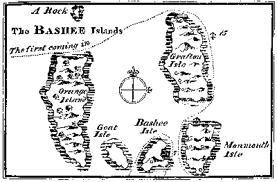
'We anchored near the North East part of this smaller Island, against a small sandy bay, in seven fathoms clean hard sand, a quarter of a mile from the shore. We presently set up a tent on shore, and every day some of us went to the towns of the natives, and were kindly entertained by them. Their boats also came on board to traffic with us every day; so that besides provision for present use, we bought and salted 70 or 80 good fat hogs, and laid up a good stock of potatoes and yams.
Names given to the Islands. Orange Island. 'These Islands lie in 20° 20′ N.[82] As they are laid down in the charts marked only with a figure of 5, we gave them what names we pleased. The Dutchmen who were among us named the Westernmost, which is the largest, the Prince of Orange's Island. It is seven or eight leagues long, about two leagues wide, and lies almost North and South. Orange Island was not inhabited. It is high land, flat and even at the top, with steep cliffs against the sea; for which reason we could not go ashore there, as we did on all the rest.
Grafton Island. 'The Island where we first anchored, we called the Duke of Grafton's Isle, having married my wife out of his Dutchess's family, and leaving her at Arlington House at my going abroad. Grafton Isle is about four leagues long, stretching North and South, and one and a half wide.
Monmouth Island. 'The other great Island our seamen called the Duke of Monmouth's Island. It is about three leagues long, and a league wide.
Goat Island. Bashee Island. The Drink called Bashee. 'The two smaller Islands, which lie between Monmouth, and the South end of Orange Island; the Westernmost, which is the smallest, we called Goat Island, from the number of goats we saw there. The Easternmost, at which we careened, our men unanimously called Bashee Island, because of the plentiful quantity of that liquor which we drank there every day. This drink called Bashee, the natives make with the juice of the sugar-cane, to which they put some small black berries. It is well boiled, and then put into great jars, in which it stands three or four days to ferment. Then it settles clear, and is presently fit to drink. This is an excellent liquor, strong, and I believe wholesome, and much like our English beer both in colour and taste. Our men drank briskly of it during several weeks, and were frequently drunk with it, and never sick in consequence. The whole group named the Bashee Islands. The natives sold it to us very cheap, and from the plentiful use of it, our men called all these Islands the Bashee Islands.
Rocks or small Islands North of the Five Islands. 'To the Northward of the Five Islands are two high rocks.' [These rocks are not inserted in Dampier's manuscript Chart, and only one of them in the published Chart; whence is to be inferred, that the other was beyond the limit of the Chart.]
Natives described. 'These Islanders are short, squat, people, generally round visaged with thick eyebrows; their eyes of a hazel colour, small, yet bigger than those of the Chinese; they have short low noses, their teeth white; their hair black, thick, and lank, which they wear short: their skins are of a dark copper colour. They wear neither hat, cap, nor turban to keep off the sun. The men had a cloth about their waist, and the women wore short cotton petticoats which reached below the knee. These people had iron; but whence it came we knew not. The boats they build are much after the fashion of our Deal yawls, but smaller, and every man has a boat, which he builds himself. They have also large boats, which will carry 40 or 50 men each.
'They are neat and cleanly in their persons, and are withal the quietest and civilest people I ever met with. I could never perceive them to be angry one with another. I have admired to see 20 or 30 boats aboard our ship at a time, all quiet and endeavouring to help each other on occasion; and if cross accidents happened, they caused no noise nor appearance of distaste. When any of us came to their houses, they would entertain us with such things as their houses or plantations would afford; and if they had no bashee at home, would buy of their neighbours, and sit down and drink freely with us; yet neither then nor sober could I ever perceive them to be out of humour.
'I never observed them to worship any thing; they had no idols; neither did I perceive that one man was of greater power than another: they seemed to be all equal, only every man ruling in his own house, and children respecting and honouring their parents. Yet it is probable they have some law or custom by which they are governed; for whilst we lay here, we saw a young man buried alive in the earth, and it was for theft, as far as we could understand from them. There was a great deep hole dug, and abundance of people came to the place to take their last farewell of him. One woman particularly made great lamentations, and took off the condemned person's ear-rings. We supposed her to be his mother. After he had taken leave of her, and some others, he was put into the pit, and covered over with earth. He did not struggle, but yielded very quietly to his punishment, and they crammed the earth close upon him, and stifled him.
Situations of their Towns. Monmouth and Grafton Isles are very hilly with steep precipices; and whether from fear of pirates, of foreign enemies, or factions among their own clans, their towns and villages are built on the most steep and inaccessible of these precipices, and on the sides of rocky hills; so that in some of their towns, three or four rows of houses stand one above another, in places so steep that they go up to the first row with a ladder, and in the same manner ascend to every street upwards. Grafton and Monmouth Islands are very thick set with these hills and towns. Bashee Islands. The two small Islands are flat and even, except that on Bashee Island there is one steep craggy hill. The reason why Orange Island has no inhabitants, though the largest and as fertile as any of these Islands, I take to be, because it is level and exposed to attack; and for the same reason, Goat Island, being low and even, hath no inhabitants. We saw no houses built on any open plain ground. Their houses are but small and low, the roofs about eight feet high.
The vallies are well watered with brooks of fresh water. The fruits of these Islands are plantains, bananas, pine-apples, pumpkins, yams and other roots, and sugar-canes, which last they use mostly for their bashee drink. Here are plenty of goats, and hogs; and but a few fowls. They had no grain of any kind.
September. 26th. 'On the 26th of September, our ship was driven to sea, by a strong gale at NbW, which made her drag her anchors. Six of the crew were on shore, who could not get on board. The weather continued stormy till the 29th. October. The 1st of October, we recovered the anchorage from which we had been driven, and immediately the natives brought on board our six seamen, who related that after the ship was out of sight, the natives were more kind to them than they had been before, and tried to persuade them to cut their hair short, as was the custom among themselves, offering to each of them if they would, a young woman to wife, a piece of land, and utensils fit for a planter. These offers were declined, but the natives were not the less kind; on which account we made them a present of three whole bars of iron.'
Two days after this reciprocation of kindness, the Buccaneers bid farewell to these friendly Islanders.
CHAP. XXII.
The Cygnet. At the Philippines, Celebes, and Timor. On the Coast of New Holland. End of the Cygnet.
1687. October. From the Bashee Islands, the Cygnet steered at first SSW, with the wind at West, and on that course passed 'close to the Eastward of certain small Islands that lie just by the North end of the Island Luconia.'
Island near the SE end of Mindanao. Candigar. They went on Southward by the East of the Philippine Islands. On the 14th, they were near a small low woody Island, which Dampier reckoned to lie East 20 leagues from the SE end of Mindanao. The 16th, they anchored between the small Islands Candigar and Sarangan; but afterwards found at the NW end of the Eastern of the two Islands, a good and convenient small cove, into which they went, and careened the ship. They heard here that Captain Swan and those of the crew left with him, were still at the City of Mindanao.
December. 27th. Near the SW end of Timor. The Cygnet and her restless crew continued wandering about the Eastern Seas, among the Philippine Islands, to Celebes, and to Timor. December the 27th, steering a Southerly course, they passed by the West side of Rotte, and by another small Island, near the SW end of Timor. Dampier says, 'Being now clear of all the Islands, and having the wind at West and WbN, we steered away SSW,[83] intending to touch at New Holland, to see what that country would afford us.'
The wind blew fresh, and kept them under low sail; sometimes with only their courses set, and sometimes with reefed topsails. 31st. The 31st at noon, their latitude was 13° 20′ S. About ten o'clock at night, they tacked and stood to the Northward for fear of a shoal, which their charts laid down in the track they were sailing, and in latitude 13° 50′ S. 1688. January. Low Island and Shoal, SbW from the West end of Timor. At three in the morning, they tacked again and stood SbW and SSW. As soon as it was light, they perceived a low Island and shoal right ahead. This shoal, by their reckoning, is in latitude 13° 50′, and lies SbW from the West end of Timor.[84] 'It is a small spit of sand appearing just above the water's edge, with several rocks about it eight or ten feet high above water. It lies in a triangular form, each side in extent about a league and a half. We could not weather it, so bore away round the East end, and stood again to the Southward, passing close by it and sounding, but found no ground. NW Coast of New Holland. This shoal is laid down in our drafts not above 16 or 20 leagues from New Holland; but we ran afterwards 60 leagues making a course due South, before we fell in with the coast of New Holland, which we did on January the 4th, in latitude 16° 50′ S.' Dampier remarks here, that unless they were set Westward by a current, the coast of New Holland must have been laid down too far Westward in the charts; but he thought it not probable that they were deceived by currents, because the tides on that part of the coast were found very regular; the flood setting towards the NE.
In a Bay on the NW Coast of New Holland. The coast here was low and level, with sand-banks. The Cygnet sailed along the shore NEbE 12 leagues, when she came to a point of land, with an Island so near it that she could not pass between. A league before coming to this point, that is to say, Westward of the point, was a shoal which ran out from the main-land a league. Beyond the point, the coast ran East, and East Southerly, making a deep bay with many Islands in it. On the 5th, they anchored in this bay, about two miles from the shore, in 29 fathoms. The 6th, they ran nearer in and anchored about four miles Eastward of the point before mentioned, and a mile distant from the nearest shore, in 18 fathoms depth, the bottom clean sand.